




No CrossRef data available.
RECONSTRUCTING AGRICULTURAL SELF-SUFFICIENCY AT CHUNCHUCMIL, YUCATAN, MEXICO
Published online by Cambridge University Press: 28 March 2006
Abstract
The Pakbeh Regional Economy Program is studying the vexing questions of economic life among the ancient Maya in northwestern Yucatan, Mexico. The region constitutes an ideal laboratory in which to investigate these questions, as it has very limited agricultural potential and fewer options for intensification than are found in the southern and central lowlands, yet many times more people lived here during the Classic period than can eke out a living today, and it has abundant evidence of market trade. Because crop yields in outfields are very low, and known intensification techniques are possibly incapable of sufficient yield enhancement, we anticipated that it would be an easy task to demonstrate that this population was dependent on imports of food and other necessities of life from beyond the region and therefore had a complex exchange economy. Twelve years later, we report on how wrong we were. We are still struggling with an evaluation of agricultural insufficiency. We explore the many and varied lines of evidence we have pursued and the confounding factors inherent in them, including problems with reconstructing ancient population size, equating contemporary and historical crop yields and farming practices, as well as ancient with modern environmental conditions, and hypothesizing potential forms of agricultural intensification, including intensive fertilization and other yield enhancement techniques, and reliance on alternative crops. The best that we can say at this juncture is that using contemporary production and consumption standards, the most conservative population estimates, and the most liberal estimates of available land in the surrounding region, we can conclude only that regional agricultural self-sufficiency remains unlikely but not proved. What initially seemed like an archaeological “no-brainer” has required us to delve into the realm of archaeological epistemology that we would like to share with our colleagues.
Information
- Type
- Research Article
- Information
- Copyright
- © 2005 Cambridge University Press
The Pakbeh Regional Economy Program (formerly the Chunchucmil Regional Economy Program) started in 1993 to investigate a paradox of economic life among the Classic-period Maya of northwestern Yucatan, Mexico (Figure 1). This region historically has been among the poorest agricultural regions in the Maya Lowlands, yet it appears to have supported one of the densest lowland Classic Maya populations (Beach 1998a; Magnoni 1995; Vlcek et al. 1978). Chunchucmil is an extraordinarily large site situated in an area with thin, stony—or no—soils (Isphording and Wilson 1973; Beach 1998a) and serious annual rainfall deficits. The mystery deepens with the general—but not entirely uncontested—consensus among Maya archaeologists that lowland Classic Maya regional polities depended largely on agricultural resources and that they were self-sufficient in food production, not least because their “tumpline economies” and lack of urban economic opportunities precluded exchange in bulk staples and other necessities of life (e.g., Drennan 1984a, 1984b; Sanders and Webster 1988), Andrew Sluyter (1993) notwithstanding. Given what initially seemed like insurmountable problems in provisioning Chunchucmil on local agricultural resources, this oddly situated city seemed to be an ideal test case for the examination of Lowland Maya urban economies in general. If it could be shown here that local agricultural resources were insufficient, then the city must have been subsidized by regional, and perhaps even extraregional, resources, and this would, of course, open the door to investigating ancient Maya urban economics at other sites.

The Chunchucmil Economic Region in northwestern Yucatan and selected natural and anthropogenic landscape features.
We are trying to resolve the problem by using a two-pronged interdisciplinary approach that evaluates environmental limitations and artifactual and architectural evidence for trade and manufacturing. We thought that the easier part would be testing the hypothesis of agricultural self-sufficiency by determining the environmental limitations imposed on agricultural productivity. If we could demonstrate that the region was not agriculturally self-sufficient, then the ancient Maya urban population must have obtained food subsidies from outside the region either through redistribution (i.e., tribute or taxes) or by means of market exchange (see Dahlin et al. 1998). The second, and more difficult, part would then be to evaluate the archaeological evidence for trade and manufacturing. We report here on our progress and problems in testing the first of these suppositions. As we will show, the deeper we penetrated the problem of agricultural self-sufficiency in this most ideal research situation, the more complicated our task became.
BACKGROUND
A brief look at the history of thought on ancient Maya urban economics suggests why our problems proliferated. The problem of ancient Lowland Maya subsistence has been a major theme in Maya archaeology, geography, and ecology for the last 30 years (e.g., Cowgill 1962; Dunning and Beach 2000; Fedick 1996; Flannery 1982; Harrison and Turner 1978; Netting 1977; Pohl 1985; Turner and Harrison 1983). It was a relatively simple and straightforward issue before that, because Mayanists dealt with only a few variables that were embedded in what is called the “myth of the milpa” (Hammond 1978): For centuries, Maya cities tended to be small and/or they contained few permanent residents (e.g., Vogt 1964), and rural settlements were widely dispersed on an undifferentiated landscape to accommodate the practice of long fallow swidden of maize (Morley 1946). Most of these studies assumed that ancient farming systems were as primitive as contemporary and historic ones and that environmental variables, especially having to do with soils and climate, were not significantly different in the prehistoric past.
In the late 1960s, however, settlement-pattern studies showed that ancient urban and regional populations far exceeded carrying capacity of long fallow swidden (e.g., Andrews 1965; Dunning and Beach 2000; Folan, Fletcher, and Kintz 1983a, 1983b; Haviland 1965). Indeed, ancient population levels throughout the Maya Lowlands are now widely believed to have been several times what they are today (Culbert and Rice 1990). When scholars realized that the modern and historic Maya had little incentive to farm intensively, given their much smaller modern populations than those at the demographic peak of the Late Classic period and during the initial phases of the Spanish Conquest, ethnographic and ethnohistoric analogies lost much of their utility. The use of ethnographic analogy and agronomic studies have become even more restricted recently because modern milperos (subsistence farmers) in the region now use petrochemical fertilizers, herbicides, and pesticides, and many of them, perhaps most, are abandoning subsistence farming altogether in favor of jobs in Cancun and Mérida and purchasing cheap maize and beans at government-subsidized village stores (Diconsa). Moreover, many regional paleoecological reconstructions are challenging how far we can extrapolate modern environmental variables onto the past (e.g., Beach 1998a; Brenner, Hodell, Curtis, Rosenmeier, Anselmetti, and Ariztegui 2003; Brenner, Leyden, Curtis, Medina Gonzalez, and Dahlin 2000; Curtis et al.1996; Dahlin 1983, 1987; Deevey et al.1979; Dunning 1992; Folan et al.1983b; Gunn and Adams 1981; Hodell et al. 1995; Leyden et al.1996; Olson 1968; Whitmore et al.1996).
Ester Boserup's (1965) notion that agricultural intensification tends to result from population pressures seemed to have saved the day, at least momentarily. Indeed, not only was there growing evidence of environmental heterogeneity (Sanders 1977; Turner 1978), but also that this “managed mosaic” (Fedick 1996) of microenvironments was filled with local agricultural-intensification practices (raised fields in karstic wetlands and terracing on hill slopes; see, e.g., Beach and Dunning 1995; Fedick 1996; Harrison and Turner 1978; Jacob 1996; Siemens and Puleston 1972; Turner 1974, 1978; Wilken 1971). But the population-pressure argument was not always supported by the data. For example, some studies found intensified farming in places that showed no evidence of population pressures (e.g., Antoine et al. 1982; Pohl et al. 1990; Pope et al. 1996), and other studies found that some places lacked intensification techniques where population pressures were probably extreme (Dahlin and Dahlin 1994; Pope and Dahlin 1989, 1993). Similarly, many studies introduced the possibility of alternative food crops (Bronson 1966; Puleston 1968, 1982). What is more, while recovery and analytical techniques improved generally in archaeology (e.g., flotation and pollen, phytolithic, chemical, and other micro- and macroscopic analyses [e.g., Cook et al. 2006; Lentz 1991, 1999; McKillop 1994; Miksicek 1983, 1990; Miksicek et al. 1991; Turner and Miksicek 1984]), preservation of organic remains is notoriously bad in tropical lowlands. Some of the most likely means of intensifying agricultural potentials (see, e.g., Wilken 1971), like polycultural gardening and tapado (see later), use biotic architecture and general farm implements that are almost totally invisible in the archaeological record.
Many important concepts that archaeologists routinely relied on, moreover, “carrying capacity” and “sustainability,” have been refined and found to be hugely elastic and dependent on virtually unknowable measurements. Carrying-capacity problems are legion, including estimating population sizes, sizes of agricultural sustaining areas, specifying ancient farming and other food-getting technologies, and quantifying normative levels of work effort and differential levels of food consumption across all social strata. Problems with calculating population estimates are well known and include contemporaneity of habitation, guess-estimates of average family size, and distinguishing between dwelling structures and ancillary buildings, to name a few (Bequelin and Michelet 1994; Rice and Culbert 1990). Despite the fact that calculating sustainability is also fraught with problems, overpopulation or environmental mismanagement has often been invoked as the deux ex machina of the Maya Collapse in the ninth and tenth centuries (e.g., Abrams and Rue 1988; Morley 1946; Santley et al. 1986; Willey and Shimkin 1973). Whether some sites stepped over the edge of the abyss and suffered the consequences in the ninth and tenth centuries, or they routinely supplemented urban food supplies through market exchange long before that, remains to be seen.
While the advances of the past 30 years can only be considered valuable, they have had the effect of exploding the number and complexity of the variables to be considered, some of which are not amenable to statistical manipulation because many key concepts have turned out to be heuristic and fuzzy. As a result of this explosion in the number and complexity of qualitative variables that make up an ancient subsistence system, many hypotheses are only weakly verifiable. Thus, it has become extremely difficult to confirm archaeologically almost any hypothesis about how urban Maya populations fed themselves. Arguments tend to rely on convergence of evidence—usually weak evidence—and to the extent that such arguments are accretive and cumulative, reports on ancient subsistence systems read more like “interim” or “progress” reports than a conclusive statement of fact. Regardless of these difficulties, the question of how the Maya made a living is the most fundamental building block in how they organized themselves economically, politically, socially, and ideologically. Therefore, we believe that the study of ancient Maya agriculture will remain a primary focus in Maya archaeology. It is in this spirit that we present our results and thinking processes on the question of how Chunchucmil fed itself.
We begin by presenting best estimates of Chunchucmil's Classic-period peak population and its distribution across the landscape. We then estimate how much land would be required to sustain this population on the basis of contemporary maize-production and maize-consumption figures to construct a first approximation model of a sustainable subsistence system. We use the complex of Chapalote-Nal-Tel maize varieties (and implicitly beans) as the main staple because it is well suited to the Maya Lowlands; it is so heavily favored in contemporary and historic accounts; it has been found virtually everywhere preservation conditions permit and systematic archaeobotanical surveys have been conducted (Lentz 1999:4); it occupies an important place in Classic-period iconography; and its grinding stones, or metates, are ubiquitous in domestic contexts at Chunchucmil. We then summarize how salient properties of the natural environment limit the intensity with which maize can be produced here; we consider soils and water-management strategies and, to a lesser degree, pest, disease, and weed control. Finally, we explore some potential intensification strategies, as well as some less well-known staple and economic crops that were potentially available to the Classic Maya and that might have expanded the productive limits and carrying capacity of the Chunchucmil region (also see Folan, Gunn, Eaton, and Patch 1983; Lentz 1999; Lundell 1938; Marcus 1982). We hasten to add that the extremely thin soils of the region—even in most middens—preclude the preservation of most organic materials, including phytoliths, pollen and bone, and the 100% bioturbation of the soils would not allow dating of these fossils even if they were preserved.
Population Estimates and Settlement Patterns
Boundary walls and streets still circumscribe and meander around residential groups at Chunchucmil, giving eloquent testimony to the fact that the city was an integrated and contemporaneous unit without significant disturbance after abandonment (Figure 2). This pattern can be dated to the late Early Classic–early Late Classic periods (a.d. 400–700, or what we call the Middle Classic period; see Varela 1998; Varela and Braswell 2003), based on ceramic and architectural dating of 36 of the hundreds of currently mapped residential groups.

Central Chunchucmil. Note the density of residential groups defined by albarradas (stone fences) and streets, and the central marketplace.
David Vlcek et al. (1978) reported an extraordinary settlement density, but our more recent detailed mapping has shown his estimates to be conservative. These data will be reported on in detail elsewhere, but a preliminary summary here will be useful (Hutson et al. 2006). By the end of the 2004 field season, we had mapped a total of 7.3 km2 of the central area of the site, including 1 km2 defined as the site center or urban core. For this paper, we have calculated population estimates based on house-mound counts within a 1.84 km2 sample area, which we feel is representative of the central 11 km2. Aerial and ground reconnaissance indicate a small drop in structural density in a 10 km2 urban zone beyond the extremely dense, central 11 km2; because settlement within this 10 km2 band is still densely urban, we feel it is appropriate to make an educated guess at its resident population. We have done so by conservatively and preliminarily cutting in half the number of structures and residents in the central 11 km2.
We discounted obviously nonresidential structures in our structure counts (e.g., temple pyramids, small ritual platforms in the center of patios, ballcourt, and so on) and ancillary buildings in house lots (e.g., storage buildings, kitchens). Moreover, we have used correction factors (Table 1) in an attempt to eliminate structures known, or suspected, to be later, such as some platform groups that appear to be Late Terminal Classic in date or other non-contemporaneous structures with the site's main occupation. After the application of these conservative correction factors, residential structural density in our sample area amounted to 530 to 595 structures/km2 (Table 1). Using an average family size of five persons (a commonly used factor in the Maya area; see, e.g., Bequelin and Michelet 1994; Rice and Culbert 1990), these numbers result in a population density of between 2,650 and 2,975 persons/km2 within the inner 11 km2 and 1,325 and 1,487 persons/km2 in the outer 10 km2. Thus, the total estimated population, is between 29,150 and 32,725 within the central 11 km2 (2,650 × 11 = 29,150 and 2,975 × 11 = 32,725) and between 13,250 and 14,870 in the outer 10 km2 sample area (1,325 × 10 = 13,250 and 1,487 × 10 = 14,870), for a total within the 21 km2 provisional area of the city of between 42,400 and 47,600 people. It should be noted that the site is a lot larger than 21 km2, but we have no way of quantifying it now. However, using analyses of aerial photographs, Landsat 7 satellite images, and limited ground surveys, we are beginning to recognize residential peripheries that might encompass yet another 29–49 km2 (Mazeau and Hixson 2005).
Structure Density At Chunchucmil

Land Required for Agricultural Self-Sufficiency
Regardless of the final population estimates, our preliminary figures of 42,400–47,600 people are sufficient to suggest that regional agricultural self-sufficiency using contemporary maize-production and maize-consumption figures is problematic. As a consequence of the poor precipitation and soil conditions (see later), average milpa production today in the Chunchucmil region is very low—about .25 metric tons/ha without the use of fertilizer and up to 1 metric ton/ha in an ideal year (see Beach 1998a). These yield estimates are in basic agreement with those from Komchen (without fertilizers), which also has deficient soils and rainfall (Shuman 1974). Here yields are said to be about .25 metric tons in a good year, and in mediocre years yields can be as low as .1m ton/ha (Shuman 1974:158). To put these yield estimates in perspective, we offer the following comparisons: average world yield equals 4.6 metric tons/ha (Pinstrup-Andersen 1994); yields near Lamanai in northern Belize with deeper soils and plentiful rainfall equals 1.7–.8 metric tons, depending on how long milpas were worked (Arnason et al. 1982); two-year average yields in Xocen, Quintana Roo, also with deeper soils and plentiful rain but with moderate use of fertilizer is less than 1 metric ton/ha (Terán and Rasmussen 1994); and yields in the Piste region near the center of the northern peninsula, with deeper soils and more precipitation, was about.75 metric ton/ha (Steggerda 1941).
Under subsistence conditions, a Maya family of five consumes a little more than a metric ton of maize per year at Piste and Komchen (Shuman 1974; Steggerda 1941). Based on long fallow swidden agriculture yields of .1–1 ton/ha, this family's annual food requirements, therefore, are between 1 ha and 10 ha actually under production, which leaves precious little margin of safety. With an average solar size of 4,233 m2, or .42 ha, available to residents in the 21 km2 core and residential districts, only a tiny fraction of a household's maize requirements could be produced, and this does not include the spaces occupied by buildings and nonagricultural activity areas estimated by Thomas Killion (1992) at 60%. With a population of 8,480–9,520 families (42,400–47,600 persons divided by an average family size of five persons), urban Chunchucmil would have needed a total of 8,480–95,200 ha, or 84.8–195.2 km2 of maize under production in outfields in any given year. However, fields can only be used for about two years without significant yield declines due to soil-nutrient depletion and weed competition (Beach 1998b). They are left fallow for 10–12 years, though fallow times have recently shortened with the advent of chemical inputs. Using chemical inputs and assuming contemporary indigenous 10–12 year fallow practices, then the 8,480–9,520 families within the 21 km2 sample area would have needed a total of 424–1,171 km2 of cultivable land available to them (Table 2).
Preliminary High and Low Estimates of Land Required to Sustain Chunchucmil's Urban Population Based on Long Fallow

Whether that amount of land was available in the region is problematic. First, Chunchucmil is bounded by an agriculturally unproductive savanna that fingers toward it to the west; Oxkintok's sustaining area, which begins fewer than 16 km to the east-southeast (Misión Arqueológica de España en México 1987–1990); and Siho's sustaining area 16 km to the south (Dunning and Andrews 1994). The savanna to the west is inundated up to a meter deep in some places during the growing season, and this prohibits the cultivation of staple food crops. A few narrow fossil beach ridges (ca. 1–1.5 m high) known locally as tzekeles present few and relatively tiny viable planting and habitation surfaces here. Moreover, there are no vestiges of wetland agriculture in the freshwater swamps immediately to the west of the savanna. We have therefore excluded all wetlands from our estimate of the agriculturally productive land in what we had initially defined as the Chunchucmil Economic Region or sustaining area (see Dahlin and Ardren 2002). We currently estimate the maximum extent of the surrounding arable land at about 1,600 km2, but a considerable overlap with Oxkintok's and Siho's sustaining areas is contained within that 1,600 km2 area using a Thiessen polygon as a guide to drawing site boundaries. Therefore, we do not know the precise size of Chunchucmil's sustaining area, but it must be significantly less than 1,600 km2. It is clear, even at this juncture, that only the high-end estimate using the shortest fallow cycle and the highest yields can accommodate even our lowest population estimate.
Second, our Classic-period population estimates leave out the 29–45 km2 of the residential periphery. It seems plausible to us that not even the 10 year fallow cycle that is common today could have sustained the entire population within the combined urban core, residential zone, and periphery, and for reasons stated later, the fallow cycle could not be shortened much beyond 10 years.
Third, with virtually no land pressures exerted by extremely low population densities today relative to those projected for Chunchucmil's population climax, contemporary farmers have more options and can be selective about where they place their milpas. For example, they can avoid planting on large portions of the land covered by limestone pavement and the very thinnest soils, and they can plant in the deep, fertile soils developed over the last 1,300 or so years on abandoned Classic-period building slopes. Therefore, productivity of milpas strategically placed to maximize fertility and soil depths today greatly exaggerates Classic-period productivity.
It should be clear from the foregoing that the nature of the science makes any estimates of population and production broad. However, our estimates are based on the most conservative demographic and production figures. While these estimates are far from conclusive, they are sufficient at this stage to sustain the hypothesis of agricultural insufficiency based on contemporary milpa practices. They also compel us to examine factors that would influence strategies of agricultural intensification.
NATURAL LIMITS ON MAIZE PRODUCTION
The landscape conditions discussed here directly affect growing conditions for all cultivars, but since maize is the heavy favorite, it will receive more attention.
Precipitation
Successful cultivation of maize requires a minimum of about 500 mm of rainfall during its growing period (Wellhausen 1957). A total of 640–900 mm is available in the study area in an average growing season, but a high percentage of that is lost in karstic seepage through the permeable limestone bedrock and in evapotranspiration, resulting in a mean annual water-budget deficit of 600–700 mm (Instituto Nacional de Estadística, Geografía e Informática 1983; Luzzadder-Beach 2000). Also, a high percentage of the rainfall occurs between May and September, which limits production to one crop per year.
The convectional precipitation regime is advected by southeasterly trade winds bringing moisture in from the Caribbean Sea westward across the peninsula. Satellite imagery thus reveals that the western and northern portions of the peninsula are in the rain shadow of the eastern peninsula, which depletes rain clouds increasingly as they move westward (Williams 1976). Thus, the Chunchucmil Economic Region receives less benefit from the southeasterlies than regions to the east and south.
Just as important as the amount of rainfall are its regularity and predictability, which affect clearing and burning, seed germination and maturation, and harvesting of crops. It is well known that precipitation on the northern peninsula is unpredictable in its occurrence because of highly localized convectional thunderstorms, droughts, and hurricanes. Some years have three to four times more rain than other years (Lundell 1934), and modern figures show variations by as much as 30% from the long-term average (Instituto Nacional de Estadística, Geografía e Informática 1981). Some of this variability is due to hurricanes, which recur on average every eight to nine years. However, the ethnohistoric and historic literature is full of references to drought (see Gill 2000 for the most complete discussion of droughts). Particularly troublesome in some years is a long, often devastating canicular drought in the middle of the growing season that exaggerates year-to-year variability and growing conditions. Paleoecological indications in lake-core sediments 30 km north of Chunchucmil reflect essentially the same climatic conditions throughout the Classic period (Brenner et al. 2000; Leyden et al. 1996). Particularly sensitive lake-core data from the eastern side of the peninsula show frequent and enormous fluctuations in precipitation (Curtis et al. 1996). Thus, rainfall amounts and variability today—and in the past—are difficult for maize. Moreover, we might expect the extreme aridity of the region might select against some of the more hydric and mesic cultivars used by the more southerly Maya and select for cultivars that can withstand prolonged drought. As we will see later, only a few of the latter cultivars have been seriously entertained as staple foods.
Maize yields could still have been bountiful with enough irrigation, but two of the most serious factors limiting settlement on the northern plains are water accessibility and quality. There are no rivers or lakes in the region, and rainwater percolates rapidly down through the top 2–4 m of porous, fractured bedrock to a mounded water table. Ironically, too much water hampers crops in places where clay plugs limestone pores and water ponds up for several weeks after large storms, which are frequent during the growing season.
Geomorphic Features
The region is a remarkably flat karstic plain wedged between the Sierrita de Ticul on the east and broad savanna and coastal swamp/estuary zones to the west (Figure 1). A cap rock, about 1 m thick, covers a fractured and extremely porous Quaternary and Pliocene limestone, which is laced with veins and pockets of sascab (a soft, crumbly limestone) (Dunning et al. 1998; Perry et al. 2003). Bedrock outcrops, or uitzes, pockmark the landscape to the north, east, and south of the site and increase in micro-elevation from west (ca. 1 m) to east (ca. 3 m). These uitzes are highly fractured and contain relatively deep pockets of richer, more water-conserving soils (see later).
Depressions, or dolines, are fairly common, although cenotes open to the water table are exceedingly rare in most of the study area. Instead, the landscape is dotted with shallow (ca. 1–3 m deep) rejolladas, or dry solution features. The rejolladas, as well as sascaberas, contain rich organic soils but are generally too small to provide much in the way of bulk staples.
Natural drains measuring just a few centimeters in diameter are common. While they are visible only on bare limestone pavements, they are probably much more numerous. Although large expanses of ground support puddles and even ponds for some time after rains, unseen drains conduct an unknown, but probably voluminous, quantity of surface water down to the water table. Larger (ca. 1–1.6 m in diameter and perhaps as deep as 90 cm) swallow holes collect some rainwater for weeks after heavy rains. They look deceptively like wells or cisterns. They, like the drains, would have provided deep, moist soils for trees such as ramon or brosimum alicastrum.
Hydrology
Water accessibility and quality are two serious factors limiting settlement on the northern plains. There are no rivers or lakes in the region, and natural and easily accessible water sources are rare on the cultivable portion of the region, although they are quite common in the uncultivable savanna (see later). Two reservoirs about 250 m apart are located in the epicenter, but they are clearly too small and their waters too ephemeral, even at the height of the wet season today, to have been secure sources of potable water, much less sources for pot irrigation. Chultunes, or cisterns, that are so common elsewhere in the northern Maya Lowlands (Matheny 1971; McAnany 1995) are unknown. We have found a total of 20 modern and ancient Maya wells, using informants within about a 5 km radius of the site center, and four wells beyond that. We excavated three wells in or near the site center (Dahlin and Jones 1998). In addition to the two reservoirs in the epicenter, four wells are known in the civic or communal spaces; the rest occur within residential units.
With a land-surface gradient from sea level at the coast to Chunchucmil about 27 km to the east less than 20 cm/km (Perry et al. 1989, 1995, 2003), the water table is quite high—some 2–3 m—and not much deeper elsewhere in the immediate vicinity (Luzzadder-Beach 2000). Wells are easy to dig in the soft limestone under the cap rock (Ringle and Andrews 1988); in fact, they are much easier to dig than chultunes (see Matheny 1971). The depth to the water table might also have been lessened by locating wells in rejollada floors, large natural drains or sascaberas (gravel or sascab quarries dug just under the cap rock into the walls of rejolladas). However, we have not seen evidence of wells in rejolladas floors and natural drains, of which three of the latter were excavated. Sascaberas sometimes retain a few centimeters of rainwater for weeks after large storms, but the availability of these waters is too unreliable during normal years, let alone during the common drought years. Moreover, only about 25% of households had sascaberas. Nevertheless, sascaberas were obviously of great importance to ancient Maya families insofar as all of them so far observed are walled off from public access by dry-laid stone walls or albarradas (Magnoni 1995). In almost all cases, the undermined cap rock has collapsed, which presented a formidable risk factor in antiquity and has deterred us from further testing. One villager in Chunchucmil Pueblo, however, found a well at the bottom of collapse debris in an ancient Maya sascabera. Today he uses it to pump water to a fine huerta (orchard) as well as for his family's potable water.
There probably were more wells than are currently accessible, since some wells may be obscured by collapse debris and others deliberately covered to prevent children or livestock from falling in them. Nevertheless, after having mapped 7.3 km2 in great detail and paying considerable attention to water accessibility, we remain perplexed by the paucity of water sources, given the high precipitation deficits in the region and the high population estimates.
One possible solution to the dilemma may rest on developing a sea-level curve on the nearby shores of the Gulf of Mexico. Rainwater percolates down to a mound of freshwater that floats on a deep bed of salt water (Back and Hanshaw 1976; Luzzadder-Beach 2000; Perry et al. 2003). This freshwater mantle is well connected to the Gulf of Mexico via caverns inasmuch as fluctuating water levels in wells have been observed throughout the day and night. This articulation of the aquifer with the Gulf of Mexico means, in turn, that depth to the water table at any point on the landscape will fluctuate with sea-level changes.
The question of sea-level changes is potentially an important one. Karen Walker and her colleagues (Walker 2000a, 2000b; Walker et al. 1994) have found evidence from Florida of rising levels from about 60 cm below pmsl (present mean sea level) circa 1050 and 50 b.c. By about a.d. 250–500, sea level began to crest at perhaps as much as 137 cm above pmsl. This was followed by an interval of falling sea levels to about 60 cm below pmsl between circa a.d. 500 and 750. W.F. Tanner (1992) and F.W. Stapor and colleagues (1991) both report another rise in sea level and transgressions in the Gulf of Mexico in the ninth–eleventh centuries. We are compiling evidence that the Florida sea-level changes approximate in time, direction, and magnitude those recorded on the coasts of the Yucatan Peninsula (also see Dahlin et al. 1998; McKillop 1995). We do not want to argue the applicability of these proxy data here other than to say that they probably result from the same eustatic processes and that the depth of ancient wells in near-coastal areas such as Chunchucmil should mark the prevailing sea stand at the time each was dug.
Water in some of Chunchucmil's ancient wells is currently up to about 140 cm deep; other wells have only about 40 cm of water; and still others have no water in them at all. In all cases, however, there is invariably a small ledge about 40 cm above the floor. This ledge was very convenient to sit on during our well excavations in 1998 and probably was used in the same fashion by the original well digger. No doubt the ledge was kept to help tip vessels while they were being filled; about 40–50 cm of water below the ledge is more than ample for submerging and filling water vessels, and it would be almost impossible to dig much farther without drowning. The elevation of the top of the ledge should therefore reflect the height of the water table. Thus, we believe that those wells with more than 100–110 cm of water above the ledge were dug when the water table was up to 1m below pmsl, while those with a water line very near the ledge were dug when sea level approximated pmsl, and those wells with no water were dug when the water table was higher than pmsl.
Suffice it so say here that high sea stands of this magnitude would force large inland transgressions of the swamp/estuary zones and perhaps the savanna on this exceedingly low and flat coastal plain and this in turn would mean a considerable encroachment on arable land. Conversely, more cultivable land might have been available during periods of low sea stands as these wetlands retreated. The magnitudes of expansions and contractions of cultivable land might well have been significant at particular points in Chunchucmil's land-use history. This possibility obviously deserves more research. Also deserving of more hydrological research is the fact that access points to groundwater currently appear to be too thinly distributed among Chunchucmil's households and outfields to have provided much irrigation, despite the region's marginal precipitation.
Soils
Between 25% and 50% of the ground surface lacks any soil at all, as noted over the years by Bishop Landa (Tozzer 1941:181) to modern commentators (Beach 1998a; Isphording and Wilson 1973; Perry et al. 2003). Where soils do exist in this environment, they are often skeletal, a fact that restricts nutrient uptake and soil-moisture capacity. These soils are often underlain by dense petrocalcic layers, which provoke localized soil flooding and hinder the development of young crops during wet periods. At least 30% of the rest of the landscape is covered by thin, reddish brown, and dense clay soils locally called kancabs (Paleustalfs, Haplustolls, and Haplustalfs in U.S. Department of Agriculture [USDA] terms). Thus, 55% to 80% of the present-day landscape has thin to no soil.
The remainder of the landscape is covered by thicker, more fertile, black, moisture-conserving clay loam, or boxluums (Calciustolls and Haplustolls in USDA terms), that develop on ancient Maya architecture, in fractured cobble and gravel limestone, on uitzes (among the most preferred sites for cultivation for farmers today), and in rejolladas. The young boxluums on mounds and plazas would not have been available to the ancient Maya. Although more boxluum soils are distributed around the site than in the rest of the karst plain, we are uncertain of the proportion that naturally occurs in bedrock fractures and rejolladas, as opposed to that formed over the past 1,000 years on abandoned Maya architecture. But with 55% to 80% of the landscape covered either by limestone pavement or thin kancab soils, the boxluum pockets on broken and pockmarked terrain might have been a pull factor for settlement and a permanent economic advantage to the descendants of the original pioneers.
There is no reason to think these conditions did not prevail in antiquity because the landscape could not have eroded away, as was suggested about this region in the past (cf. Conservation Foundation 1954; Robles Ramos 1950). Unlike the central Maya Lowlands, where steep slopes led to significant soil erosion in the Preclassic through Classic periods, and the Maya developed conservation mostly in the Late Classic (Beach, Luzzadder-Beach, Dunning, and Scarborough 2003; Beach, Dunning, Luzzadder-Beach, Cook, and Lohse 2006; Beach, Luzzadder-Beach, Dunning, Hageman, and Lohse 2002), the Chunchucmil plains are too flat (far less than 1° slopes on average) for much soil erosion by runoff, and the high clay content and vegetative cover preclude much wind erosion. These fundamental factors that make erosion unlikely here are attested by the very small amounts of eroded sediments in local depressions and in the Cenote San Jose Chulchaca core 30 km to the north (Brenner et al. 2000; Leyden et al. 1996).
It is natural weathering and nutrient removal by crops that are the major soil-fertility losses in this landscape. Organic matter, base saturation, cation-exchange capacity, calcium, magnesium, sodium, iron, and nitrogen are generally at healthy levels, but the essential nutrients of phosphorous, potassium, and zinc are variable but generally low (Beach 1998a). Removal of harvested crops from the field substantially diminishes soil nutrients, and soil manipulation can lead to the decomposition of organic matter, a storehouse of essential nutrients. Milpa production in the Maya Lowlands and elsewhere in the tropics is always challenged by weed (and pest) encroachment, especially after the first year of cropping. Indeed, most recent evidence indicates that weed accumulation and the mounting labor required for weeding are the primary causes for abandonment (Beach 1998b; Kellman and Tackaberry 1997:217).
In the lowlands of Belize, John T. Arnason and colleagues have provided a number of baseline studies of plant, soil, and nutrient interactions in shifting cultivation (Arnason et al. 1982; Brubacher et al. 1989; Lambert et al. 1991). They conclude that yield declines were due to weed competition for light and water because by the third year of cropping, weeds had more of all macronutrients than corn. Milpa weeds increased annually, holding more and more nutrients in each year of cropping (Arnason et al. 1982; Brubacher et al. 1989). Fallow leads to the succession of woody plants and trees over herbaceous weeds and diminishes the number of weed seeds over time (weed seeds can stay viable for more than 45 years). Thus, the most important role of fallow is controlling weeds. Lambert and Arnason (1989) found that a two-year cropping cycle with slash and burn was the most efficient use of nutrients and weed competition. The differences between the sites in these studies support the contention by Pedro Sanchez (1976) that milpa abandonment occurs on poor soils because of reduced nutrients but that it occurs on rich soils due to weed competition for light and water (also see Dahlin 1987).
Based on milpa agriculture in Yucatan, sustainable cropping requires either a minimum of 10–12 years of fallow to restore adequate levels of phosphorous, the minimum fallow period practiced by contemporary traditional farmers today (Shuman 1974)—or mulching. Nitrogen is sufficient at most study sites in the region except in deeply buried soils that are removed from the organic cycling and increases by nitrogen fixation in the common leguminous vegetation of the region, to say nothing of the restorative effects of inter-cropping with nitrogen-fixing legumes. Thus, phosphorus values limit the fallow cycle to not less than 10–12 years and impose the strictest limit on agricultural intensification.
Finally, we note that fluctuations in the water table due to changing sea levels may have influenced the amount of arable land that was available, as they have a tremendous potential for expanding and contracting the savanna zone on this exceedingly low and flat landscape. These expansions and contractions in turn make more agricultural land available during periods of low water, such a during the Late Classic period, and less land for cultivation during high0water intervals, such as, perhaps, during the Early Classic period.
POTENTIAL INTENSIFICATION STRATEGIES AND ALTERNATIVE CROPS
Since soils are already thin and their organic matter is prone to decomposition and some compaction without the maintenance of vegetative cover, careful crop-intensification techniques would be necessary to guard against declines in organic matter and soil structure. These, along with the shortage of land, deficient rainfall, sparseness and thinness of the soils, and easily exhausted phosphorous are the most important limitations for agriculture. Intensification strategies concentrate on using space more efficiently; improving water management; increasing the depth, fertility, and moisture-holding capacity of the soil using perishable materials; and perhaps using more nutritious and productive alternative crops than we are accustomed to recognizing.
Maximizing Ground Space
Scott Hutson and colleagues (2006) selected a sample of 75 residential groups that were completely bounded by albarradas to give an idea of the range and median of solar (yard) size and therefore the amount of land potentially available for outdoor activity areas, including kitchen gardens, urban orchards, and infields. After subtracting the surface area of architecture, solar sizes were seen to range from .075 ha to .75 ha, with a median of .253 ha. Solar size does not correlate with distance to site center, but it does correlate with volume of stone architecture and floor area, both measures of group size. Thus, the more populated residential groups had more potential planting surface, but there were, of course, more mouths to feed. Settlement density and small solar sizes precluded sufficient maize production in Chunchucmil's urban area by a wide margin. However, solares might have allowed some intensive gardening or seedbed cultivation, particularly if all available ground space had been maximized and protected. That they were protected is demonstrated by the sharp definition of solares, gardens, orchards, and infields by albarradas and callejuelas, or streets.
A well-known space-saving intensification technique is polycultural gardening, which attempts to maximize precious land surfaces by distributing crops vertically rather than horizontally (Atran 1993; Barrera 1980; Barrera et al. 1977; Folan et al. 1983a; Killion 1992; Nations and Nigh 1980; Stuart 1993). Such systems include some combination of root crops, such as jicama (Pachyrhizus erosus [L] Urb.), yucca (Manioc esculenta), cocoyam (Xanthosoma sp.), and sweet potato (Ipomoea batatas [L] Lam.) in the subsoil; ground-hugging herbs, vegetables and shrubs in lower stories; shade-tolerant tree species in middle stories (e.g., balche, lonchocarpus); and larger trees in upper stories (e.g., ramon) and dominants (e.g., Folan et al. 1983; Wiseman 1978). These systems combine the strengths and weaknesses of different crops on the same plot to fix nitrogen, conserve soil moisture, distribute sunlight, and minimize pests. Polycultural gardening has received a good deal of agroecological research, which has brought many intensification techniques of this kind to light that were fully within the capacity of the ancient Maya to use (e.g., Gómez-Pompa 1987; Hernandez 1980; Reyes and Sanchez 1990; Terán and Rasmussen 1994; Varguez Pasos 1981; Vargas et al. 1985; Zizumbo Villareal and Colunga García-Marín 1993; Zizumbo Villareal et al. 1992).
Staple polycultural crops, however, tend to be nuts, grains, or roots. Polycultural gardening is best practiced in regions with greater rainfall and deeper soils than are generally found at Chunchucmil, and it is not well developed in the region today (however, see Ortega et al. 1993). Moreover, polycultural gardening is difficult to demonstrate archaeologically because its efficacy is due to judicious use of biotic architecture, which does not preserve well in the archaeological record. Recent pollen evidence at Cobá (Leyden et al. 1998), nevertheless, demonstrates the process of removing maize fields from Cobá's site center during the site's demographic peak in the Late Classic period, a process that can be interpreted as an attempt to maximize the efficiency of urban land use for habitation and associated gardens and orchards.
Ambiguous evidence for arboriculture in Chunchucmil's residential district lies in occasional piles of rough stone, about 3 m in diameter. These stone circles, or “chich mounds,” may be the remnants of “tree foundations” intended to conserve moisture; they are at least superficially similar to walls erected around large trees for that purpose in Yucatan today (Kepecs and Boucher 1996). Rejolladas and sascaberas provide other opportunities for arboriculture. Arturo Gómez-Pompa and colleagues (1990) and Susan Kepecs and Sylviane Boucher (1996) make a good case for growing cacao (Theobroma cacao) in the much larger and more ubiquitous rejolladas, cenotes, and sascaberas along the northern coast, and William Folan (1978:84) reports that the contemporary Maya around Coba intensively garden these features today. In fact, within Chunchucmil, both rejolladas and sascaberas are confined to private yards and are protected from public access by albarradas. Finally, large natural drain holes in solares might have served as “tree planters.” We excavated three such units that had a diameter of about 1 m. Two of the drains contained very little cultural material, a finding that we feel is consistent with their use as tree planters inasmuch as a tree trunk would have blocked the orifice from being used as a midden. The third drain contained abundant cultural material, but it was located at the back of a house that stood on top of a meter-high platform; it is possible that cultural material below such an artifact-rich environment (perhaps a midden) tumbled into the drain sometime after a tree ceased to occupy it. Thus, these features—chich mounds, rejolladas, sascaberas, and natural drains—no doubt provided important economic products for those households fortunate enough to have them.
The most likely candidate for a staple arboricultural crop and alternative to maize is, of course, ramon, even though Chunchucmil lies beyond Dennis Puleston's (1968) zone where ramon thrives due to the aridity and thin to nonexistent soils. This broad-crown canopy tree produces a highly nutritious and storable nut that we know was eaten at least during times of famine (e.g., Alcorn 1984; Atran 1993; Lentz 1993; Puleston 1968, 1982; Tozzer 1941). Fossil pollen record its presence almost throughout the Holocene here (Leyden et al. 1996), and today ramon trees grow in reasonably well-developed regional second growth (mature stands of forest being exceedingly rare), but they appear to be relatively stunted. Tree crops such as ramon can thrive in shallow soils, when they can tap into deeper water sources. They may not achieve the height, maturity, and productivity as in the well-watered south, or along the Paseo Montejo in Mérida, where these large, memorable trees are heavily irrigated. But this requirement does not eliminate ramon from the small list of potentially important food supplements because mature economic trees are almost certainly capable of sending down taproots through the fractured limestone to offset water shortage, or they could be planted in the natural drains that dot the landscape.
Puleston (1982:361) cites one ramon study stating that in better-watered areas of Yucatan and Campeche, a single large tree can produce up to 60 kg of edible seed annually, and in these same areas where ramon leaves provide valuable forage materials for cattle and horses, a spacing of 100–125 trees/ha can be maintained. This spacing would allow some under-story cropping and produce between 5,700 and 10,100 kg of edible seed/ha, which is far in excess of the annual basic subsistence needs of a family of six. With a median of.253 ha, however, most solares at Chunchucmil are too small to contain more than 20–25 broadly crowned trees without shading out many highly valued herbaceous comestibles and nursery crops that require a great deal of sunlight. Nor does it allow for the stunting of all subtropical and tropical tree species in this dry zone of northwestern Yucatan. Nevertheless, under these most optimistic conditions, ramon groves of this size might produce about 1,200–1,500kg/year. Consumption figures are not available for ramon, but if we assume for the sake of argument that ramon and maize are of approximately the same nutritional value (see Puleston 1968, 1982) and that a family of five can subsist on a little more than a metric ton of maize per annum, then it is possible for that same family to subsist totally on a diet of home-grown ramon. Chich mounds, rejolladas, sascaberas, and natural drains no doubt did provide important economic products for those households fortunate enough to have them. Given the prevailing thin soils and generally deficient rainfall over most of the urban landscape, the small size of most solares, and the fact that chich mounds, rejolladas, sascaberas, and natural drains are few in number, and generally small in size, it seems unlikely that ramon could have provided much in the way of bulk food staples.
There are other reasons to speculate that ramon served only as a dietary supplement rather than as a broadly relied on staple at Chunchucmil. First, its botanical remains have never been found at any site other than Cobá (Lentz 1999:13). Second, ethnohistorical analogy does not favor heavy reliance on kitchen gardens for basic staple production. Javier Caballero (1992) writes that only about 11% of the average domestic calorie intake is produced in kitchen gardens. Despite the fact that the historic and modern Maya value their orchards highly, polycultural gardens are normally limited to market products (Herrera 1994:26) and nutritional and dietary supplements, medicinal herbs, and plants used as ornamentals and ritual objects rather than bulk staples such as ramon (Caballero 1992). Third, ramon, as is well known, is, and historically was, held in very low regard as a food stuff (Puleston 1968). Thus, while we can probably eliminate ramon as a food staple for most of Chunchucmil's population, we cannot eliminate it as a food supplement.
Water Management
Pot irrigation remains the most promising water-management practice, given the high water table and the ease of well digging through the soft limestone bedrock. As we suggested earlier, excavation of wells would have been made even easier on sascabera floors, but sascaberas are found in only about a quarter of the residential units we have mapped thus far. Rellojadas also would have lowered the ground surface to make the water table more accessible in wells, and this would have increased the opportunities to pot irrigate urban gardens. Given the difficulty in finding wells on the ground surface and on rejollada and sascabera floors, it is even possible that well water, like sascab (Dahlin and Ardren 2002), was commodified and sold or bartered to neighbors to pot irrigate their gardens. Be that as it may, it seems unlikely that pot irrigation was widely practiced in milpas outside the city, where many wells and huge amounts of labor to dig, maintain, and use them would be needed. Local informants have not reported the existence of wells outside the city on karstic plains to the north, east, and south. However, wells—some modern—abound in the savanna to the west, especially next to tzekeles, where the water table is just centimeters below the ground surface and crops on these micro-topographic highs can be pot irrigated. Alternatively, apiaries are often associated with these water sources; indeed, the abundance of apiaries here is unparalleled.
Water-quality studies revealed that potability for domestic use and consumption is limited by the concentrations of nitrate (N), sulfate (SO4), and chloride (Cl). Mean Cl levels of 188 mg/l (milligrams/liter) place Chunchucmil's ground-water quality in the “increasing problems” category of toxicity from root absorption (Luzzadder-Beach 2000; Luzzadder-Beach et al. 1986). This means that tree or woody crops are more vulnerable to root absorption toxicity than are annual crops, but high levels of salinity, and total dissolved solids (TDS) limit field crops, as well. TDS and salinity bear close linear relationships to the field measure Electrical Conductivity (EC, measured here as microsiemens or μ). Chunchucmil's ground water EC averaged 1,174 μS, but individual wells ranged from 310 to 3,100 μS (Luzzadder-Beach 2000), which can translate to a 0% to 35% reduction in maize yields due to root absorption and salinity, depending on the individual water source's EC (Luzzadder-Beach et al. 1986, California Department of Water Resources 1978) .
Analysis of ground-water chemistry produced two rather surprising results. First, water quality in terms of N is relatively good in the region, despite numerous point sources for pollution (e.g., corrals and human settlement), probably due to rapid flushing of the aquifer (Luzzadder-Beach 2000). But second, high Cl values may be restrictive with respect to agriculture. Cl values above 142 mg/l indicate increasing problems with root absorption by tree crops, and values above 106 mg/l mean increasing problems with foliar absorption in annual field crops (California Department of Water Resources 1978; Luzzadder-Beach et al. 1986). Fourteen wells showed Cl concentrations exceeding these values. It is not yet known how restrictive these high Cl values are with respect to the kinds of crops the ancient Maya were probably cultivating, but they could be consequential when added to the limitations imposed by soil chemistry and climate.
In sum, while serious rainfall deficits would seem at first glance to present serious limitations to agricultural productivity, pot irrigation from nearby wells could be used in dooryard cropping systems, and tree species with tap roots capable of penetrating the water table might also thrive. But we do not know how ground water's high salinity may negatively affect productivity of annuals and tree crops.
Soil-Fertility Management
Soil organic matter is subject to rapid tropical decomposition and rapid cycling. Burning and harvesting crop plants remove soil nutrients that must then be renewed. The soil nutrients that normally pose the most important limitations to agricultural productivity are phosphorus and nitrogen. Unfortunately for us, there are no direct means of measuring Classic Maya additions of soil organic matter and nitrogen (but see later). Nitrogen replacement was, and is, not a serious problem with fallowing and crop rotation because the low deciduous forest that covers the region has a high percentage of endemic, nitrogen-fixing legumes. In fact, second-growth seres have up to 90% of such species (Flores and Espejel Carvajal 1994:70).
Improving nitrogen can also be done by green manuring or clipping a legume cover crop in milpas and gardens and adding it as mulch. This is essentially the same idea as the underreported but widespread method of mulching called “tapado.” Tapado is the practice of interplanting a green cover crop, usually a legume that will fix nitrogen, add some phosphorous, protect the soil from erosion, ameliorate soil structure and water movement, enhance fertility, and suppress weeds and perhaps pests (Reyes and Sanchez 1990; Thurston et al. 1994). The cover crop is periodically clipped and composted in situ. Agronomists at CINVESTAV (Centro de Investigaciones y de Estudios Avanzados) are currently experimenting with tapado, but the efficacy of this strategy is not clear thus far.
Phosphorus replacement is the single most limiting factor. We can estimate ancient additions of phosphorus by means of phosphate fractionation (e.g., Beach 1998a; Eidt 1985; Lillios 1992). A relative high Fraction 2 to Fraction 1 can indicate phosphate enrichment in the past. Fraction 1 is the most soluble fraction, a nonoccluded fraction bound with iron and aluminum. Fraction 2 measures phosphorus occluded within iron oxides, and hydrous oxides resists weathering, and persists for very long periods of time. At Residential Chunchucmil, likely ancient soils have low Fraction 1 compared with Fraction 2 in an infield, a soil buried under a sacbe, a small sink, and a sascabera. High fractionation ratios elsewhere (Table 3) may indicate that Chunchucmil's soils experienced some kind of ancient phosphorous enrichment. Likewise, the five lowest ratios all occur on what are likely sediments deposited since the Late Classic period and not fertilized by ancient Maya farmers.
Phosphate Fractionation of Chunchucmil Soils (partly based on Beach 1998a)

These findings are very different from the P-fractionations (N = 10) from Sayil (Dunning 1992), where the total phosphorous mean is 538. 9 mg kg-1 (milligrams per kilogram), and the ratio of Fraction 2 to Fraction 1 is .082. The same figures for Chunchucmil are a total phosphorous mean of 340.1mg kg-1, and the mean ratio of Fraction 2 to Fraction 1 is 2.8. Compared with those at Sayil, even the modern used soils with the lowest phosphorous values at Chunchucmil still have high phosphorous-fractionation ratios (.94–1.39), which may be remnants of less intensive historical fertilization or the byproduct of mixing with a highly fertilized ancient landscape.
There are a variety of ways in which the Maya could have improved phosphorus in the soil: mulching with household wastes, composting, and importing soils and organic matter from wetlands and/or burnt sascab. Collection of household wastes might have provided a bit more nitrogen to dooryard gardens, but again, nitrogen is not a serious problem. Night soil and other household wastes were no doubt collected, processed, and spread on gardens, although the quantity would not have made a dramatic difference. Regardless of how effective waste fertilization was in infields (see Bull et al. 1999), the sheer size of milpas and their distance from habitations clearly limited the use of waste and organic-matter fertilization in outfields.
Another possibility is the importation of quarried soils. Villagers today quarry soils on their hunting forays into the savanna to provide a base for specific garden plants, often flowers. These trips to the savanna can result in up to 400 kg (ca. .3–.4 m3) of savanna soils per year, but there is no limit, of course, if a household wanted to build up the soil in raised beds. This practice is in fact done on a larger scale by the modern residents of both Cobá and Chan Kom (Folan 1978; Redfield and Villa Rojas 1934:46). So far, we have tried to distinguish ancient raised beds in domestic contexts on the basis of surface survey and soil chemical tests, but we will soon make more quantifiable distinctions through excavation and further tests of soil chemistry and biomarkers (e.g., aquatic or amphibious snails) of imported savanna or estuary soils.
Organic matter rich in phosphorus might also have been composted and imported from the swamp estuary or savanna zones. This compost might then have been spread on beds. Indeed, we observed a number of rock alignments in solares that originally could have contained about 200–500 m2 raised beds. We estimate that each bed would have required at least 10–20 cm deep mixture of organic matter with soil. Using these figures, each raised bed would require from 20 m3 to 100 m3, or about 10–70 metric tons, of transported organic sediment. A conservative estimate of 20–40 kg for how much a person could carry to build the beds means that it would require 250 to 1,750 trips to build the beds over a number of years and at least 25 trips per year to replenish decomposed organic matter. Since current farmers travel five or more kilometers with heavier loads of wood and soil on almost a regular basis, ancient Maya farmers could have maintained raised beds in this zone from imported organic matter. Certainly, over a period of years farmers would have had to walk farther and farther for their soil imports or actively cultivated organic matter (Beach 1998a; Palacios-Mayorga et al. 2003).
Another possibility that will continue to confound our estimates of sustainable productivity in solares for some time to come is the possible importation of periphyton (Fedick 2003; Fedick et al. 2000; Morrison and Cozatl-Manzano 2003; Palacios-Mayorga et al. 2003). These algal mats are said to be rich in phosphates, nitrogen, organic matter, and cation-exchange capacity. They are ubiquitous in seasonal and perennial wetlands and are easily transportable after drying into cakes. Beth A. Morrison and Roberto Cozatl-Manzano (2003) found small freshwater snails within higher-drier settings in the Yalahau region of northern Quintana Roo, implying the gathering of periphyton for soil enrichment, and today trucks haul large quantities of periphyton to fertilize gardens. We are nevertheless struck by the fact that milperos and dooryard gardeners outside of this zone are totally ignorant of its benefits even though they have lived intimately with it for generations.
The fairly common alignments of stones that are now flush with the ground surface in residential units could have been retaining walls for raised beds; still other raised beds might have been built of wattle or other perishable materials and are now unrecognizable. Their proximity to sascaberas and wells in solares would have greatly facilitated pot irrigation. Raised beds are often used today as nurseries to control germination and boost the vigor of seedlings and saplings before transplanting to outfields. With significant improvements in the depth of soils, raised beds could contribute significantly to cultivation. In fact, some local farmers do grow root crops in raised beds in their kitchen gardens today, but the roots mainly add variety to the diet. Based on the number of sascaberas and wells recorded so far in residential units, however, only about a quarter of all households could have had pot-irrigated nurseries.
If some form of mulching of Classic-period gardens is likely, fertilization of outfields seems much more difficult except for green manuring and fallowing. If fallow cycles in milpas were reduced much beyond ten years, sustainable cultivation would absolutely necessitate the importation and application of phosphorous and other essential nutrients. If indeed the ancient Maya were able to use all the intensification techniques discussed, then they may have been able to sustain their families based on much smaller outfields, as have, for example, rural societies in Asia. It should be clear from the figures given earlier, however, that the amount of labor seems staggering; we also have no ethnohistorical precedent and only a glimmer of archaeological evidence.
Alternative Crops Not Previously Considered
An alternative means of achieving agricultural self-sufficiency might entail xerophytic cultivars that Mesoamerican foragers and incipient cultivators used widely as basic foodstuffs—acacia, guaje, nopal, and agave (Flannery 1986). These highly productive xerophytic plants are native to northwestern Yucatan (Flores and Espejel Carvajal 1994:63–65) and are better adapted to the prevailing climatic and edaphic conditions than the more popular—and more problematic—cultivars such as maize and beans. Perhaps of some relevance is the fact that some of the earliest densely settled agricultural communities on the northern plains were located near the inner margins of the savanna (Garza Tarazona de Gonzalez and Kurjack 1981:19–20), where these highly productive forage foods are most abundant. Of course, these ecotones also would have provided early Maya farmers with access to both land and marine resources.
Acacia, or mesquite (Propsopis spp.), and guaje (Leucaena spp.) are rich in protein and carbohydrates. They are legumes, so they fix nitrogen in the soil. Both trees are found in abundance in the savanna and in secondary growth, including fallowing fields.
The genus Agave includes 136 species, of which seven or eight have been widely used for food and fiber (see Parsons and Parsons 1990). One species of Agave, also called henequen, maguey, sisal, yucca, or century plant (Agave fourcroydes), is well suited to the semi-aridity and thin soils of northwestern Yucatan and is remarkably productive in the face of the storms, droughts, and pests that ravage maize. Indeed, the commercial crop henequen virtually blanketed northwestern Yucatan in the “henequen zone” until recently; its fiber for making twine and rope has been Yucatan's most important commercial export.
Agave pulquero (as well as henequen) may have a long history in Yucatan, since its Mayan name, “Ki,” is also the term for wine (Clemency Coggins, personal communication 1997). In fact, almost every part of the agave plant—its edible leaves, hearts, inflorescences, and sap or aguamiel—can be eaten fresh, prepared in a variety of ways (e.g., in roasting pits or in roasting piles on top of the ground surface) or dehydrated for storage. The flesh is very sweet and tastes something like baked yams (Schneider et al. 1996), but because it is fibrous, it must be heavily masticated leaving a fibrous quid. The flesh and even the blossoms (Schneider et al. 1996) can be dehydrated, ground into a flour, stored for a matter of months, and then made into a bread. We have no figures on the caloric and nutritional values of roasted agave flesh. The leaves can be harvested at any time without endangering the mature plant. The plant also supports a worm or grub that is edible when roasted and salted. In the highlands, agave products are eaten most often just before harvests when stores of maize are lowest. In addition to being drunk directly as a sweet refreshing drink, the aguamiel can be fermented into pulque (and, of course, recently distilled into tequila), let to sour into vinegar, heated to convert into loaves of crystallized sugar that can then be stored or traded, and made into medicinal preparations (for ointment and/or poultice for wounds and snake bites). It is important to note that, depending on how the henequen leaves are processed for agualmiel, the fibers can be used to make a variety of cordage products afterward (Colunga García-Marín 2003).
Sustained aguamiel production can occur only by harvesting mature plants (eight to 25 years old). Therefore, most agave plants will be unproductive in any given year and will occupy a good deal of planting space. Nevertheless, Susan Evans (1992:110) estimates that in Cihuatecpan in the Mexican highlands, a 1.6 ha plot of agave intercropped with maize and consumed in the form of aguamiel produces enough calories to sustain a family of five or six persons at the subsistence level for a whole year. Moreover, David Lentz and colleagues (1996) report a Classic-period infield and/or garden that was densely planted with agave at the volcanic ash buried site of Cerén, El Salvador, and Landa (Tozzer 1941) reported its cultivation in house gardens in sixteenth-century Yucatan (also see Colunga García-Marín 2003).
The fact that there is no intensive use of Agave pulquero in Yucatan today or historically is curious, but Yucatan is not unique in this respect. Jeffrey Parsons and Mary Parsons (1990:269) note in highland Mexico that “the flesh, sap, and fiber of the maguey plant have been prepared, distributed, and consumed in a variety of ways that have either disappeared completely from the modern scene, or have been very substantially modified relative to their prehispanic analogs” (see also Evans 1992). The kinds of tools used to process agave are not terribly distinctive from ordinary domestic tools (Parsons and Parsons 1990) except, perhaps, if ceramic vessels were used to ferment pulque and roasting pits if the flesh was prepared for roasting. However, artifactual evidence of agave's use in cordage products might include larger than normal spindle whorls (Parsons and Parsons 1990). Perhaps the best chances of recognizing agave production is in microscopic wear patterns on stone tools and in plant residues. Agave leaves contain oxalate and phosphate crystals that act to store and retain water molecules, and these elongated crystals might be recognizable both in soils where the fibers were processed and on tools.
Finally, the cactus nopal (Opuntia spp.) is potentially important because it occupies a niche that most other plant life avoids: the extremely thin soils around patches of limestone pavement. Nopal has very little nutritional value, but the fruit (tuna) is relatively high in sugar, vitamin C, and many of the B vitamins (Borrego E. and Burgos V. 1986). The tuna is eaten raw or cooked. It is often made into a candy, preserve, or syrup that can be fermented into colonche, a mild narcotic drink. Tuna “cheese” was made from the ground pulp of the fruit seed. Nopal has several medicinal uses, including as an anti-inflammatory (in the form of a poultice) and in the management of non-insulin-dependent diabetes mellitus.
It seems unlikely that the ancient Maya in the Chunchucmil region used acacia, guaje, agave, and nopal as primary food staples. The questions are: How much did the the Maya rely on them? And could they have fully compensated for chronic shortfalls in maize? We have no ready answers.
Other Rock Alignments
Finally, rock alignments have just been discovered in parts of the seasonally inundated savanna to the west of Chunchucmil (Hixson 2004). They resemble rock alignments found in similar wetlands of the Holbox Fracture Zone, northern Quintana Roo (Fedick 2003; Fedick et al. 2000). According to Scott Fedick, such rock alignments may have supported some sort of subsistence activities—for example, “to control the movement of soil … [for the] cultivation of domestic crops or the encouragement of edible or economically useful wetland resources” (Fedick et al. 2000), but, like Fedick and his colleagues, we cannot specify what those activities were. The alignments may have increased the frequency and areas of ephemeral stagnant pools, which would foster the development of soils, periphyton, and reed and insect colonies, as well as attract game. It cannot be ruled out, however, that the rock alignments functioned as narrow causeways for foot traffic across the inundated savanna—to provide access to wild wetland resources such as ramon stands, wild game, palm, reeds, edible insects, as well as to small milpas located on distant tzekeles and, eventually, to the headwaters of canals leading to the coast. We remain open to the possibility that these rock alignments served both functions, just as canalized fields provide for both transportation and water management at other Maya sites. Additional studies are under way.
SUMMARY AND DISCUSSION
The problem of ancient Maya subsistence has no simple and straightforward answers. Although hypotheses abound, we cannot point to a single case where there is a consensus on how a Lowland Maya site fed itself. Needless to say, we on the Pakbeh Regional Economy Program are in this same unenviable position of indeterminacy. We understood some of the difficulties in doing this kind of research from the very beginning; we did not anticipate other difficulties. For example, we understood that our purview would have to be broad, long-term, and expensive, allowing for the likelihood that the subsistence economy was mixed, with some dependence on maize, roots, ramon, and other nutritional supplements from hunting, gathering, and dooryard gardening, and perhaps from critical imports of fish, shellfish, and marine mammals. We also understood that even to attempt to resolve some of the most important issues, the research would have to be empirically driven, flexible, and open to new ideas. And many of those new directions (many of them blind alleys) would demand new scientific expertise in a well-coordinated, multifaceted, and interdisciplinary research program. However, we had the hubris to think that the serious moisture deficits and thin soil base at Chunchucmil would simplify matters for us. But as elsewhere, the number of new lines of inquiry burgeoned beyond expectation, and each new fact presented yet more new lines of evidence that we had to pursue. To be sure, population levels can be shown to have been high and agricultural productivity within the region demonstrably low. Moreover, the host of natural limiting factors was expectable: a climate that allows only one crop per year; either too much or too little water supply making agriculture risky; skeletal soils; deficits in soil-phosphorus replacement, and so on. Other limitations were novel—for example, potential groundwater toxicity for young plants (thus limiting the effectiveness of pot irrigation) and possibly fluctuations in the amount of cultivable land due to sea-level changes. The sum of these limiting factors cast doubt on the hypothesis that this population was agriculturally self-sustaining.
Human ingenuity in coping with such limits is remarkable, however, and there were intensification options. As dry as the region is, polycultural gardening could have been practiced in solares to maximize ground space. The landscape has a high water table that is easily reached by the taproots of large, economic trees such as ramon. Not only would sascaberas and rejolladas have conserved soil moisture, but wells dug in floors would have allowed easy pot irrigation of infield and garden crops. The region is blanketed with a thin and easily exhausted soil mantle, yet the soil base in dooryard gardens might have been improved by constructing raised beds and nurseries or using traditional approaches to improving soil fertility (e.g., green manuring, fertilizing with household wastes, rock mulching, and importing of fertile soils from wetlands). There also remains the possibility of nontraditional approaches that might have been long since forgotten, such as using periphyton and wetland rock alignments. And still to be considered are a variety of ill-considered alternative crops.
We are finding out that many key aspects of these important variables are qualitative, forcing us to make “educated guesses” about their relative contributions to the total subsistence system rather than measuring them. Given the enormous elasticity of most of the variables we must deal with, we cannot expect a great deal of precision in our answers.
If we have learned anything over the past 12 years, it is that most of the known or hypothesized intensification techniques are limited to solares and infields. Some of these intensification techniques probably could not have boosted production in solares by more than a very few percentage points; others, such as pot irrigation of gardens, nurseries, and orchards would have had a greater impact on productivity. It is nevertheless difficult, given the size of solares, to envision such gardens, nurseries, and orchards providing the bulk of food requirements. It is equally difficult to envision intensification techniques that could have elevated maize yields significantly in outfields, even though a laborious agricultural self-sufficiency is possible at the low end of our population estimates for the region and at the high end of our outfield maize-production estimates. As things stand now, however, Chunchucmil would have suffered severe food deficits within the middle to high ranges of our population estimates and the middle to low ranges of food production. Therefore, we can say unequivocally that this population was perched precariously on the edge of disaster for centuries; it somehow managed its subsistence affairs better than that; or it provided for itself through trade or tribute coming from a larger surrounding macro-region for reasons that have nothing to do with regional agricultural potential.
Needless to say, our cautionary tale will be far from popular among environmental archaeologists and those who wish for more precision. But the question of how the Maya sustained themselves is an important one and will not go away. Therefore, we must continue to refine our methods and incorporate or develop new lines of evidence. We, for example, have embarked on a program of residue analyses of artifacts (grinding and cutting implements and interior vessel surfaces), architectural features such as floors and walls, and surface and buried soils from potential activity areas in solares, infields, wells, and rejolladas. The residues include starches, fatty acids, chemical elements, and fossil-plant remains. These efforts have recently paid off in the form of a marketplace (Figure 2), which was identified by extraordinarily high phosphate values and rows of the remains of market stalls (Dahlin 2003; Dahlin et al. 2006); the high phosphate values signal the processing, vending, and wastage of organic materials. This discovery should not be interpreted as total reliance on imported food stuffs, however, for it seems to be a rather small area, given the relative enormity of Chunchucmil's urban and surrounding populations.
When financial resources permit, we will also begin a major program of burial excavations to recover more human skeletal remains for chemical and stable isotopic analyses (carbon, nitrogen, oxygen, and strontium) and analyses of skeletal and dental pathologies to assess overall nutritional and health status (see Mansell et al. 2002; White 1999; Whittington and Reed 1997). For rather than the truth shining through with a few stunning demonstrations of fact, it will no doubt emerge slowly out of a diverse array of independent lines of evidence.
RESUMEN
Este artículo hace referencia a una de las preguntas básicas, pero más difíciles que concierne a la antigua cultura de las Tierras Bajas Mayas: ¿Cómo se alimentaban las grandes poblaciones urbanas? Chunchucmil, en el noroeste de Yucatan, México, parece ser el laboratorio ideal para investigar dicha pregunta. Esto se debe a que la región circundante tiene un limitado potencial agrícola y sin embargo, tenía mucha más gente de la que ahora vive allí. Por esto pensamos que debido a que las cosechas son tan bajas podía ser fácil demostrar que la antigua población dependía de la importación de comida y de otros productos necesarios. Esta hipótesis fue reforzada por la alta concentración de residuos orgánicos encontrada en el área de mercado, la que da testimonio acerca del procesamiento de comida, su venta y los deshechos. Sin embargo, la dependencia en este pequeño mercado todavía tiene que ser demostrada.
A pesar de haber seleccionado una investigación simple para examinar esta pregunta (una población urbana extraordinariamente alta para la cantidad de tierra agrícola disponible), confesamos que después de 12 años de intensa investigación todavía estamos luchando por responderla. En primer lugar, ofrecemos una breve historia del pensamiento acerca de la economía de subsistencia de los antiguos Mayas para así identificar algunas áreas con problemas conceptuales y empíricos. A lo largo de más de 30 años hemos heredado una gran cantidad de complejas variables y muchas de ellas no son receptivas a la manipulación estadística, por lo que solo llevan a una verificación débil. Después examinamos cómo algunas de las variables más relevantes pueden emplearse en la investigación de Chunchucmil. Nuestro intento más reciente por reconstruir la antigua población del sitio, nos ha brindado un rango conservador de entre 42,400 a 47,000 personas habitando en 21 km2, que es la máxima extensión de la ciudad. Sin embargo, este rango no considera a la población rural que también fue densa. Asumiendo que tenían una dieta predominantemente de maíz y utilizando los resultados químicos, en conjunto con las prácticas de barbecho de 10 a 12 años de los indígenas contemporáneos, esta población necesitó un mínimo de de tierra cultivable de entre 424 a 1,171 km2.
Es problemático saber si esta cantidad de tierra estaba disponible o no en la región. Hoy día las restricciones naturales en la producción del maíz incluyen: déficit en la precipitación pluvial, la cantidad y calidad de las tierras elevadas durante la época de crecimiento y la disponibilidad de agua subterránea para su manejo. Las limitaciones epistemológicas incluyen el problema de equiparar las cosechas contemporáneas y prácticas agrícolas con las cosechas prehistóricas y la reconstrucción confiable de las antiguas condiciones ambientales, donde la preservación de materiales orgánicos era pobre. Algunas formas de intensificación agrícola, que pensamos fueron practicadas bajo mayores presiones demográficas que ahora, tales como la maximización del espacio de tierra con jardinización policultural, técnicas de manejo de agua como la irrigación con vasijas, o el manejo de la fertilización de la tierra con fertilizantes y el reemplazo de suelo a gran escala, eran poco viables o, probablemente no habrían incrementado las cosechas significativamente. Existe poca información para evaluar el potencial de algunos cultivos alternativos como las legumbres arbóreas, es decir la acacia y el guaje y, las plantas xerofíticas como el agave y el nopal. Después de 12 años de investigación intensa, lo que podemos decir es que utilizando las estimaciones de población más conservadoras y las estimaciones más liberales de tierra disponible en la región circundante, es que esta población: (1) por siglos se ubicó de forma precaria en el eje del desastre; (2) de alguna forma manejo sus asuntos de subsistencia mucho mejor que eso; o (3) proveyó para sí misma a través del intercambio o del tributo que venía de lejos. No es necesario decir, que aún con el panorama más sencillo, el demostrar la auto-suficiencia agrícola prehistórica es una tarea difícil.
References
REFERENCES
Abrams, Elliot M., and
David J. Rue
1988
The Causes and Consequences of Deforestation among the Prehistoric
Maya.
Human Ecology
16:377–395.CrossRefGoogle Scholar
Andrews IV, E. Wyllys
1965
Progress Report on the 1960–1964 Field Seasons, National
Geographic Society–Tulane University Dzibilchaltun Program. Middle
American Research Institute, Publication 31, pp.
23–67.
Tulane University,
New Orleans.Google Scholar
Antoine, Pierre P.,
Richard L. Skarie, and
Paul R. Bloom
1982
The Origin of Raised Fields near San Antonio, Belize: An
Alternative Hypothesis. In
Maya Subsistence: Studies in Memory of Dennis E. Puleston,
edited by
Kent V. Flannery, pp.
227–236.
New York:
Academic Press.CrossRefGoogle Scholar
Arnason, John T.,
John D. Lambert,
J. Gale,
J. Cal, and
H. Vernon
1982
Decline of Soil Fertility Due to Intensification of Land Use by
Shifting Agriculturists in Belize, Central America.
Agro-Ecosystems
8:27–37.CrossRefGoogle Scholar
Atran, Scott
1993
Itza Maya Tropical Agro-Forestry.
Current Anthropology
34:633–700.CrossRefGoogle Scholar
Back, William S., and
B. B. Hanshaw
1976
Hydrochemistry of the Northern Yucatán Peninsula. In
Carbonate Rocks and Hydrogeology of the Yucatán Peninsula,
Mexico, edited by
A.E. Weidie and
W.C. Ward, pp.
211–243.
New Orleans Geological Society,
New Orleans.Google Scholar
Barrera Rubio, Alfredo
1980
Sobre la unidad de habitación tradicional campesina y el
manejo de recursos bióticos en el area maya
yucatánense. Biótica
5(3):
115–129.Google Scholar
Barrera Rubio, Alfredo,
Arturo Gómez-Pompa, and
C. Vazquez-Yanez
1977
El manejo de las selvas por los Mayas: Sus implicaciones
silvícolas y agrícolas.
Biótica
2(2):78–96.Google Scholar
Beach, Timothy
1998a
Soil Constraints on Northwest Yucatán: Pedo-archaeology and
Maya Subsistence at Chunchucmil.
Geoarchaeology
13:759–791.3.0.CO;2-B>CrossRefGoogle Scholar
Beach, Timothy
1998b
Soil Catenas, Tropical Deforestation, and Ancient and Contemporary
Soil Erosion in the Petén, Guatemala.
Physical Geography
19:378–405.CrossRefGoogle Scholar
Beach, Timothy, and
Nicholas P. Dunning
1995
Ancient Maya Terracing and Modern Conservation in the Peten Rain
Forest of Guatemala.
Journal of Soil and Water Conservation
50:138–145.Google Scholar
Beach, Timothy,
Sheryl Luzzadder-Beach,
Nicholas P. Dunning, and
Vernon Scarborough
2003
Depression Soils in the Lowland Tropics of Northwestern Belize:
Anthropogenic and Natural Origins. In
Lowland Maya Area: Three Millennia at the Human–Wildland
Interface, edited by
Arturo Gomez-Pompa,
M. Allen,
Scott Fedick, and
Juan J. Jiménez-Osornio, pp.
139–174.
Haworth Press,
Binghamton, NY.Google Scholar
Beach, Timothy,
Nicholas P. Dunning,
Sheryl Luzzadder-Beach,
Jon C. Lohse, and
Duncan Cook
2006
Ancient Maya Impacts on Soils and Soil Erosion in the Central Maya
Lowlands.
Catena.CrossRefGoogle Scholar
Beach, Timothy,
Sheryl Luzzadder-Beach,
Nicholas P. Dunning,
Jon Hageman, and
Jon C. Lohse
2002
Upland Agriculture in the Maya Lowlands: Ancient Conservation in
Northwestern Belize.
Geographical Review
92(3):372–397.CrossRefGoogle Scholar
Bequelin, Pierre, and
Dominique Michelet
1994
Demografía en la zona puuc: El recurso del
método.
Latin American Antiquity
5(4):289–311.CrossRefGoogle Scholar
Borrego E., Fernando, and
Noe Burgos V.
1986
El Nopal.
Universidad Autónoma Agraria Antonio Narro Buenavista,
Saltillo, Coahuila, Mexico.Google Scholar
Brenner, Mark,
Barbara W. Leyden,
Jason H. Curtis,
Roger M. Medina Gonzalez, and
Bruce H. Dahlin
2000
Un registro de 8,000 anos del paleoclima del noroeste de Yucatan,
Mexico.
Revista de la Universidad Autonoma de Yucatan
15(213):52–65.Google Scholar
Brenner, Mark,
David A. Hodell,
Jason H. Curtis,
Michael F. Rosenmeier,
Flavio S. Anselmetti, and
Daniel Ariztegui
2003
Paleolimnological Approaches for Inferring Past Climate Change in
the Maya Region: Recent Advances and Methodological Limitations.
In
The Lowland Maya Area: Three Millennia at the Human–Wildland
Interface, edited by
Arturo Gomez-Pompa,
M. Allen,
Scott Fedick, and
Juan J. Jiménez-Osornio, pp.
45–76.
Food Products Press,
New York.Google Scholar
Bronson, Bennett
1966
Roots and the Subsistence of the Ancient Maya.
Southwestern Journal of Anthropology
22:251–279.CrossRefGoogle Scholar
Brubacher, D.,
John T. Arnason, and
John D. Lambert
1989
Woody Species and Nutrient Accumulation during the Fallow Period of
Milpa Farming in Belize, Central America.
Plant and Soil
114:165–172.CrossRefGoogle Scholar
Bull, I.,
I. Simpson,
P. van Bergen, and
P. Evershed
1999
Muck “n” Molecules: Organic Geochemical Methods for
Detecting Ancient Manuring.
Antiquity
73:
86–96.CrossRefGoogle Scholar
Caballero, Javier
1992
Maya Homegardens: Past, Present and Future.
Etnoecológica
1:35–53.Google Scholar
California Department of Water Resources
1978
Water Quality Course Manual: Introduction to Water Quality.
California State Department of Water Resources,
Sacramento.
DWR no. 6079.Google Scholar
Colunga García-Marín,
Patricia
2003
The Domestication of Henequen (Agave fourcroydes
Lem.). In
The Lowland Maya Area: Three Millennia at the Human–Wildland
Interface, edited by
Arturo Gomez-Pompa,
M. Allen,
Scott Fedick, and
Juan J. Jiménez-Osornio, pp.
439–446.
Food Products Press,
New York.Google Scholar
Conservation Foundation
1954
Soil Erosion Survey of Latin America. In collaboration with the Food
and Agricultural Organization of the United Nations.Google Scholar
Cook, Duncan,
Brigitte Kovacevich,
Timothy Beach, and
Ronald Bishop
2006
Deciphering the Inorganic Geochemical Record of Ancient Human
Activity using ICP-MS: Two Examples from Late Classic Soil Floors at
Cancuen, Guatemala.
Journal of Archaeological Science.CrossRefGoogle Scholar
Cowgill, Ursula M.
1962
An Agricultural Study of the Southern Maya Lowlands.
American Anthropologist
64:273–286.CrossRefGoogle Scholar
Culbert, T. Patrick, and
Don. S. Rice (editors)
1990
Precolumbian Population History in the Maya Lowlands.
University of New Mexico Press,
Albuquerque.Google Scholar
Curtis, Jason H.,
David A. Hodell, and
Mark Brenner
1996
Climate Variability on the Yucatán Peninsula (Mexico) during
the Last 3,500 Years and Implications for Maya Cultural Evolution.
Quaternary Research
46:37–47.CrossRefGoogle Scholar
Dahlin, Bruce H.
1983
Climate and Prehistory on the Yucatán Peninsula.
Climatic Change
5:245–263.CrossRefGoogle Scholar
Dahlin, Bruce H.
1987
Reconstructing Ancient Maya Adaptive Patterns on the Northern Plains
of Yucatán, Mexico: 1986 Interim Report. Sociology/Anthropology
Department, Howard University, Washington, DC.Google Scholar
Dahlin, Bruce H.
2003
Chunchucmil: A Complex Economy in Northwestern Yucatan.
Mexicon
25:129–138.Google Scholar
Dahlin, Bruce H., and
Traci Ardren
2002
Modes of Exchange and Regional Patterns: Chunchucmil,
Yucatan. In
Ancient Maya Political Economies, edited by
Marilyn A. Masson and
David A. Freidel, pp.
249–284.
AltaMira,
Walnut Creek, CA.Google Scholar
Dahlin, Bruce H., and
Andrea Dahlin
1994
Platforms in the Akalche at El Mirador, Peten, Guatemala, and Their
Implications.
Journal of Field Archaeology
9(4):1–35.Google Scholar
Dahlin, Bruce H., and
John Jones
1998
Preliminary Paleoecological Studies at Chunchucmil.
Paper presented at the 63rd Annual Meeting of the Society for
American Archaeology,
Seattle.Google Scholar
Dahlin, Bruce H.,
Christopher T. Jensen,
Richard E. Terry,
David R. Wright, and
Timothy Beach
2006
In Search of an Ancient Maya Marketplace.
Latin American Antiquity.Google Scholar
Dahlin, Bruce H.,
Anthony P. Andrews,
Timothy Beach,
Clara Bezanilla,
Patrice Farrell,
Sheryl Luzzadder-Beach, and
Valerie McCormick
1998
Canbalam in Context: A Report on a Peripatetic Coastal Site in
Northwest Campeche, Mexico.
Ancient Mesoamerica
9:1–15.CrossRefGoogle Scholar
Deevey, Edward S.,
Don S. Rice,
Prudence Rice,
Hague H. Vaughan,
Mark Brenner, and
Michael S. Flannery
1979
Mayan Urbanism: Impact on a Tropical Karst Environment.
Science
206:298–306.CrossRefGoogle ScholarPubMed
Drennan, Robert D.
1984a
Long Distance Movement of Goods in the Mesoamerican Formative and
Classic.
American Antiquity
49(1):27–43.CrossRefGoogle Scholar
Drennan, Robert D.
1984b
Long Distance Transport Costs in Pre-Hispanic Mesoamerica.
American Anthropologist
86:105–112.CrossRefGoogle Scholar
Dunning, Nicholas P.
1992
Lords of the Hills: Maya Settlement in the Puuc Region,
Yucatán, Mexico.
Monographs in World Archaeology No. 15.
Prehistory Press,
Madison, WI.Google Scholar
Dunning, Nicholas P., and
George F. Andrews
1994
Ancient Maya Architecture and Urbanism at Siho and the Western Puuc
Region, Mexico.
Mexicon
16(3):53–61.Google Scholar
Dunning, Nicholas P., and
Timothy Beach
2000
Stability and Instability in Pre-Hispanic Maya Landscapes.
In
Imperfect Balance: Landscape Transformations in the Precolumbian
Americas, edited by
D. Lentz, pp.
179–202.
Columbia University Press,
New York.CrossRefGoogle Scholar
Dunning, Nicholas P.,
Timothy Beach,
Patrice Farrell, and
Sheryl Luzzadder-Beach
1998
Prehispanic Agrosystems and Adaptive Regions in the Maya
Lowlands.
Culture and Agriculture
20:87–101.CrossRefGoogle Scholar
Eidt, Robert C.
1985
Theoretical and Practical Considerations in the Analysis of
Anthrosols. In
Archaeological Geology, edited by
George Rapp, Jr. and
John A. Gifford, pp.
155–190.
Yale University Press,
New Haven, CT.Google Scholar
Evans, Susan T.
1992
The Productivity of Maguey Terrace Agriculture in Central Mexico
during the Aztec Period. In
Gardens of Prehistory: The Archaeology of Settlement Agriculture in
Greater Mesoamerica, edited by
Thomas W. Killion, pp.
92–116.
University of Alabama Press,
Tuscaloosa.Google Scholar
Fedick, Scott L.
1996
The Managed Mosaic: Ancient Maya Agriculture and Resource
Use.
University of Utah Press,
Salt Lake City.Google Scholar
Fedick, Scott L.
2003
Archaeological Evidence for Ancient and Historic Resource Use
Associated with the El Eden Wetland, Northern Quintana Roo, Mexico.
In
The Lowland Maya Area: Three Millennia at the Human–Wildland
Interface, edited by
Arturo Gomez-Pompa,
M. Allen,
Scott Fedick, and
Juan J. Jiménez-Osornio, pp.
339–360.
Food Products Press,
New York.Google Scholar
Fedick, Scott L.,
Bethany A. Morrison,
Bente J. Anderson,
Sylviane Boucher,
Jorge Ceja Acosta, and
Jennifer P. Mathews
2000
Wetland Manipulation in the Yalahau Region of the Northern Maya
Lowlands.
Journal of Field Archaeology
27:131–152.Google Scholar
Flannery, Kent V.
1982
Maya Subsistence: Studies in Memory of Dennis E. Puleston.
Academic Press,
New York.Google Scholar
Flannery, Kent V.
1986
Guila Naquitz: Archaic Foraging and Early Agriculture in Oaxaca,
Mexico.
Academic Press,
Orlando.Google Scholar
Flores, José S., and
Ileana Espejel Carvajal
1994
Tipos de Vegetación de la Península de Yucatán.
Etnoflora Yucatánense, Fascículo 3. Universidad
Autónoma de Yucatán/Sostenibilidad Maya,
Mérida.Google Scholar
Folan, William J.
1978
Cobá, Quintana Roo, Mexico: An Analysis of a Prehispanic and
Contemporary Source of Sascab.
American Antiquity
43:79–85.CrossRefGoogle Scholar
Folan, William J.,
Lorraine A. Fletcher, and
Ellen R. Kintz
1983a
Fruit, Fiber, Bark and Resin: Social Organization of a Maya Urban
Center.
Science
204:679–701.Google Scholar
Folan, William J.,
Lorraine A. Fletcher, and
Ellen R. Kintz
1983b
Cobá: A Classic Maya Metropolis.
Academic Press,
New York.Google Scholar
Folan, William J.,
Joel Gunn,
Jack D. Eaton, and
Robert W. Patch
1983
Paleoclimatological Patterning in Southern Mesoamerica.
Journal of Field Archaeology
10:453–467.Google Scholar
Garza Tarazona de Gonzalez, Sylvia, and
Edward B. Kurjack
1981
El medio ambiente y los asentamientos mayas en epoca
prehispánica. In
Memoria del Congreso Interno 1979: Mérida,
México.
Centro Regional del Sureste,
Instituto Nacional de Antropología e Historia,
Mérida.Google Scholar
Gill, Richardson B.
2000
The Great Maya Droughts.
University of New Mexico Press,
Albuquerque.Google Scholar
Gómez-Pompa, Arturo,
José S. Flores, and
Mario Aliphat F.
1990
The Sacred Cacao Groves of the Maya.
Latin American Antiquity
1(3):247–257.CrossRefGoogle Scholar
Gunn, Joel, and
Richard E.W. Adams
1981
Climate Change, Culture, and Civilization in North America.
World Archaeology
13:87–100.CrossRefGoogle Scholar
Hammond, Norman
1978
The Myth of the Milpa: Agricultural Expansion in the Maya
Lowlands. In
Pre-Hispanic Maya Agriculture, edited by
Peter D. Harrison and
B.L. Turner II, pp.
23–34.
University of New Mexico Press,
Albuquerque.Google Scholar
Harrison, Peter D., and
B.L. Turner II (editors)
1978
Prehispanic Maya Agriculture.
Albuquerque:
University of New Mexico Press.Google Scholar
Haviland, William
1965
Prehistoric Settlement at Tikal, Guatemala.
Expedition
7(3):14–23.Google Scholar
Hernandez X, Efrain
1980
Seminario sobre producción agrícola en
Yucatán.
Gobierno de Yucatán,
Secretaria de Programación y Presupuesto de Agricultura y
Recursos Hidráulicos (SPPSARH), Colegio de Postgraduados en
Chapingo, Yucatán, Mérida.Google Scholar
Herrera Castro, Natividad D.
1994
Los huertos familiares mayas en el oriente de Yucatán.
Etnoflora Yucatánense, Fascículo 9. Universidad
Autónoma de Yucatán/Sostenibilidad Maya,
Mérida.Google Scholar
Hixson, David
2004
Preliminary Report of the 2002 Regional Settlement Pattern
Survey. In
The Pakbeh Regional Economy Program: Report of the 2002 Field
Season, edited by
Bruce H. Dahlin and
Daniel Mazeau, pp.
16–23.
Howard University,
Washington, DC.Google Scholar
Hodell, David A.,
Jason H. Curtis, and
Mark Brenner
1995
Possible Role of Climate in the Collapse of Classic Maya
Civilization.
Nature
375:391–394.CrossRefGoogle Scholar
Hutson, Scott R.,
Aline Magnoni,
Daniel E. Mazeau, and
Travis Stanton
2006
The Archaeology of Urban Houselots at Chunchucmil, Yucatán,
Mexico. In
Lifeways in the Northern Lowlands: New Approaches to Maya
Archaeology, edited by
Jennifer Mathews and
Beth Morrison.
University of Arizona Press,
Tucson.Google Scholar
Instituto Nacional de Estadística, Geografía e
Informática
1981
Carta de precipitatión total anual, 1:1,000,000.
Mexico City.Google Scholar
Instituto Nacional de Estadística,
Geografía e Informática
1983
Carta de evapotranspiration y deficit de agua.
Mexico City.Google Scholar
Isphording, Wayne C., and
Eugene M. Wilson
1973
Weathering Processes and Physical Subdivisions of Northern
Yucatán.
Proceedings of the Association of American Geographers
5:117–121.Google Scholar
Jacob, John S.
1996
Archaeological Pedology in the Maya Lowlands. In
Pedological Perspectives in Archaeological Research, edited
by
M. Collins.
Soil Science Society of America,
Madison.Google Scholar
Kellman, Martin, and
Roseann Tackaberry
1997
Tropical Environments: The Functioning and Management of Tropical
Ecosystems.
Routledge,
New York.CrossRefGoogle Scholar
Kepecs, Susan M., and
Sylviane Boucher
1996
The Prehispanic Cultivation of Rejolladas and Stonelands: New
Evidence from Northeast Yucatán. In
The Managed Mosaic: Ancient Maya Agriculture and Resource Use,
edited by
Scott L. Fedick, pp.
69–91.
University of Utah Press,
Salt Lake City.Google Scholar
Killion, Thomas W.
1992
Residential Ethnoarchaeology and Ancient Site Structure:
Contemporary Farming and Prehistoric Settlement Agriculture at
Matacapán, Veracruz, Mexico. In
Gardens in Prehistory, edited by
Thomas W. Killion, pp.
119–149.
University of Alabama Press,
Tuscaloosa.Google Scholar
Lambert, John D., and
John T. Arnason.
1989
Role of Weeds in Nutrient Cycling in the Cropping Phase of Milpa
Agriculture in Belize, Central America. In
Mineral Nutrients in Tropical Forest and Savanna Ecosystems,
edited by
J. Proctor, pp.
301–313.
Blackwell Scientific,
New York.Google Scholar
Lambert, John D.,
D. Brubacher, and
John T. Arnason
1991
Nutrient Mobility in a Shifting Cultivation System, Belize, Central
America. In
Agroecology: Researching the Ecological Basis for Sustainable
Agriculture, edited by
Steven R. Gliessman, pp.
122–129.
Springer-Verlag,
New York.Google Scholar
Lentz, David L.
1991
Maya Diets of the Rich and Poor: Paleoethnobotanical Evidence from
Copan.
Latin American Antiquity
2:269–287.CrossRefGoogle Scholar
Lentz, David L.
1993
Medicinal and Other Economic Plants of the Maya of Honduras.
Economic Botany
47:358–370.CrossRefGoogle Scholar
Lentz, David L.
1999
Plant Resources of the Ancient Maya: The Paleoethnobotanical
Evidence. In
Reconstructing Ancient Maya Diet, edited by
Christina D. White, pp.
3–18.
University of Utah Press,
Salt Lake City.Google Scholar
Lentz, David L.,
Marilyn P. Beaudry-Corbett,
M.L. Reyna de Aguilar, and
L. Kaplan
1996
Foodstuff, Forests, Fields, and Shelter: A Paleoethnobotanical
Analysis of Vessel Contents from the Cerén Site, El
Salvador.
Latin American Antiquity
7(3):247–262.CrossRefGoogle Scholar
Leyden, Barbara,
Mark Brenner, and
Bruce H. Dahlin
1998
Cultural and Climatic History of Cobá, a Lowland Maya City in
Quintana Roo, Mexico.
Quaternary Research
49:111–122.CrossRefGoogle Scholar
Leyden, Barbara,
Mark Brenner,
Jason H. Curtis,
Dolores Piperno,
Tom Whitmore, and
Bruce H. Dahlin
1996
A Record of Long- and Short-Term Climatic Variation from Northwest
Yucatán: Cenote San José Chulchaca. In
The Managed Mosaic: Ancient Maya Agriculture and Resource Use,
edited by
Scott L. Fedick, pp.
30–52.
University of Utah Press,
Salt Lake City.Google Scholar
Lillios, Katina T.
1992
Phosphate Fractionation of Soils at Agroal, Portugal.
American Antiquity
57(3):495–506.CrossRefGoogle Scholar
Lundell, Cyrus L.
1934
Preliminary Sketch of the Phytogeography of the Yucatán
Peninsula.
Contributions to American Archaeology, No. 12. Carnegie
Institution of Washington Publication 436.
Washington,
DC.Google Scholar
Lundell, Cyrus L.
1938
Plants Probably Utilized by the Old Empire Maya of Peten and
Adjacent Lowlands.
Papers of the Michigan Academy of Sciences, Arts, and Letters
24:37–56.Google Scholar
Luzzadder-Beach, Sheryl
2000
Water Resources of the Chunchucmil Maya.
Geographical Review
90(4):493–510.CrossRefGoogle Scholar
Luzzadder-Beach, Sheryl,
Robert F. Clawson, and
Lee R. Gibson
1986
Surprise Valley Ground Water Basin Water Quality Study.
California State Department of Water Resources,
Sacramento.Google Scholar
Magnoni, Aline
1995
Albarradas at Chunchucmil and in the Northern Maya Area.
Bachelor's thesis, Institute of Archaeology, University College
London.Google Scholar
Mansell, Eugenia Brown,
Robert H. Tykot,
David Freidel,
Traci Ardren, and
Bruce H. Dahlin
2002
Stable Isotope Analysis of Human Bones from the Northern Yucatan
Peninsula Sites of Yaxuna and Chunchucmil.
Paper presented at the Annual Meetings of the Society for American
Archaeology,
Denver.Google Scholar
Marcus, Joyce
1982
The Plant World of the Sixteenth- and Seventeenth-Century Lowland
Maya. In
Maya Subsistence: Studies in Memory of Dennis E. Puleston,
edited by
Kent V. Flannery, pp.
239–274.
Academic Press,
New York.CrossRefGoogle Scholar
Matheny, Ray T.
1971
Modern Chultun Construction in Western Campeche, Mexico.
American Antiquity
36:473–475.CrossRefGoogle Scholar
Mazeau, Daniel E., and
David R. Hixson
2005
Reconocimiento regional en los aldededores del centro urbano de
Chunchucmil.
Paper presented at the 2d Congreso Internacional de Cultura
Maya,
Mérida, Yucatan.Google Scholar
McAnany, Patricia
1995
Living with the Ancestors: Kinship and Kingship in Ancient Maya
Society.
University of Texas Press,
Austin.Google Scholar
McKillop, Heather
1994
Ancient Maya Tree Cropping: A Viable Subsistence Adaptation for the
Island Maya.
Ancient Mesoamerica
5:129–140.CrossRefGoogle Scholar
McKillop, Heather
1995
Underwater Archaeology, Salt Production, and Coastal Maya Trade at
Stingray Lagoon, Belize.
Latin American Antiquity
6(3):214–228.CrossRefGoogle Scholar
Miksicek, Charles. H.
1983
Macrofloral Remains of the Pulltrouser Area: Settlements and
Fields. In
Pulltrouser Swamp: Ancient Maya Habitat, Agriculture, and Settlement
in Northern Belize, edited by
B.L. Turner II and
Peter D. Harrison, pp.
94–104.
University of Texas Press,
Austin.CrossRefGoogle Scholar
Miksicek, Charles. H.
1990
Early Wetland Agriculture in the Maya Lowlands: Clues from
Preserved Plant Remains. In
Ancient Maya Wetland Agriculture: Excavations on Albion Island,
Northern Belize, edited by
Mary Pohl, pp.
295–312.
Westview Press,
Boulder, CO.Google Scholar
Miksicek, Charles H.,
Elizabeth. S. Wing, and
Sylvia J. Scudder
1991
The Ecology and Economy of Cuello. In
Cuello: An Early Maya Community in Belize, edited by
Norman Hammond, pp.
70–84.
Harvard University Press,
Cambridge, MA.Google Scholar
Misión Arqueológica de España en
México
1987–1993
Proyecto Oxkintok,
4 vols.
Ministerio de Asuntos Exteriores,
Madrid.Google Scholar
Morrison, Beth A., and
Roberto Cozatl-Manzano
2003
Initial Evidence for Use of Periphyton as an Agricultural
Fertilizer by the Ancient Maya Associated with the El Eden Wetland,
Northern Quintana Roo, Mexico. In
The Lowland Maya Area: Three Millennia at the Human–Wildland
Interface, edited by
Arturo Gomez-Pompa,
M. Allen,
Scott Fedick, and
Juan J. Jiménez-Osornio, pp.
401–414.
Food Products Press,
New York.Google Scholar
Nations, James D., and
Ronald B. Nigh
1980
The Evolutionary Potential of Lacandon Maya Sustained-Yield Tropical
Forest Agriculture.
Journal of Anthropological Research
36(1):1–30.Google Scholar
Netting, Robert M.
1977
Maya Subsistence: Mythologies, Analogies, and Possibilities.
In
The Origins of Maya Civilization, edited by
Richard E.W. Adams, pp.
299–334.
University of New Mexico Press,
Albuquerque.Google Scholar
Nobel, Park S.
1988
Environmental Biology of Agaves and Cacti.
Cambridge University Press,
New York.Google Scholar
Olson, Gerald
1968
A Soil Survey of Tikal. Department of Agronomy, Cornell University,
Ithaca, New York.Google Scholar
Ortega, Luis M.,
Sergio Avendaño,
Arturo Gómez-Pompa, and
Edilberto Ucan Ek
1993
Los Solares de Chunchucmil, Yucatán, México.
Biótica nueva epoca
1:37–51.Google Scholar
Palacios-Mayorga, Ana Luisa Anaya,
Eleazar Gonzalez-Velazquez,
Lazaro Huerta-Arcos, and
Arturo Gomez-Pompa
2003
Periphyton as a Potential Biofertilizer in Intensive Agriculture of
the Ancient Maya. In
The Lowland Maya Area: Three Millennia at the Human–Wildland
Interface, edited by
Arturo Gomez-Pompa,
M. Allen,
Scott Fedick, and
Juan J. Jiménez-Osornio, pp.
401–414.
Food Products Press,
New York.Google Scholar
Parsons, Jeffrey R., and
Mary H. Parsons
1990
Maguey Utilization in Highland Central Mexico: An Archaeological
Ethnography.
Anthropological Papers of the Museum of Anthropology No.
82.
University of Michigan,
Ann Arbor.CrossRefGoogle Scholar
Perry, Eugene,
Guadalupe Velazquez-Oliman, and
Richard A. Socki
2003
Hydrogeology of the Yucatan Peninsula. In
The Lowland Maya Area: Three Millennia at the Human–Wildland
Interface, edited by
Arturo Gomez-Pompa,
M. Allen,
Scott Fedick, and
Juan J. Jiménez-Osornio, pp.
115–138.
Food Products Press,
New York.Google Scholar
Perry, Eugene,
Luis Marín,
Jana McClain, and
Guadalupe Velazquez
1995
Ring of Cenotes (Sinkholes), Northwest Yucatán, Mexico: Its
Hydrogeologic Characteristics and Possible Association with the Chichxulub
Impact Crater.
Geology
23(1):17–20.2.3.CO;2>CrossRefGoogle Scholar
Perry, Eugene,
Jennifer Swift,
Jose Gamboa,
Andrew Reeve,
Robert Sanborn,
Luis Marín, and
Miguel Villasuso
1989
Geologic and Environmental Aspects of Surface Cementation, North
Coast, Yucatán, Mexico.
Geology
17:818–821.2.3.CO;2>CrossRefGoogle Scholar
Pinstrup-Andersen, Per
1994
World Food Trends and Future Food Security.
International Food Policy Research Institute,
Washington, DC.Google Scholar
Pohl, Mary (editor)
1985
Prehistoric Lowland Maya Environment and Subsistence Economy.
Papers of the Peabody Museum of Archaeology and Ethnology, Vol.
77.
Harvard University,
Cambridge, MA.Google Scholar
Pohl, Mary D.,
Paul R. Bloom, and
Kevin O. Pope
1990
Interpretation of Wetland Farming in Northern Belize: Excavations
at San Antonio, Rio Hondo. In
Ancient Maya Wetland Agriculture: Excavations on Albion Island,
Northern Belize, edited by
Mary D. Pohl, pp.
187–254.
Westview Press,
Boulder, CO.Google Scholar
Pope, Kevin O., and
Bruce H. Dahlin
1989
Ancient Maya Wetland Agriculture: New Insights from Ecological and
Remote Sensing Research.
Journal of Field Archaeology
16:87–106.Google Scholar
Pope, Kevin O., and
Bruce H. Dahlin
1993
Radar Detection and Ecology of Ancient Maya Canal
Systems—Reply to Adams et al.
Journal of Field Archaeology
20:379–383.CrossRefGoogle Scholar
Pope, Kevin O.,
Mary D. Pohl, and
John S. Jacob
1996
Formation of Ancient Maya Wetland Fields: Natural and Anthropogenic
Processes. In
The Managed Mosaic: Ancient Maya Agriculture and Resource Use,
edited by
Scott L. Fedick, pp.
165–176.
University of Utah Press,
Salt Lake City.Google Scholar
Puleston, Dennis P.
1968
Brosimum Alicastrum as a Subsistence Alternative for the Classic
Maya of the Central Southern Lowlands.
Unpublished master's thesis,
Department of Anthropology, University of Pennsylvania.
University Microfilms (no. M-3977), Ann Arbor, MI.Google Scholar
Puleston, Dennis P.
1982
The Role of Ramón in Maya Subsistence. In
Maya Subsistence: Studies in Memory of Dennis E. Puleston,
edited by
Kent V. Flannery, pp.
353–366.
Academic Press,
New York.Google Scholar
Redfield, Robert, and
Alfonso Villa Rojas
1934
Chan Kom: A Maya Village.
Carnegie Institution of Washington Publication 448.
Washington,
DC.Google Scholar
Reyes G., Dario, and
Marco A. Sanchez G.
1990
Guía para el uso continuo del terreno para producir
maíz asociado en la milpa.
Secretaria de Agricultura y Hidráulicos (SARH),
Mexico City.Google Scholar
Rice, Don S., and
T. Patrick Culbert
1990
Historical Contexts for Population Reconstruction in the Maya
Lowlands. In
Precolumbian Population History in the Maya Lowlands, edited
by
T. Patrick Culbert and
Don S. Rice, pp.
1–36.
University of New Mexico Press,
Albuquerque.Google Scholar
Ringle, William M., and
E. Wyllys Andrews V
1988
Formative Residences at Komchen, Yucatán, Mexico. In
Household and Community in the Mesoamerican Past, edited by
Richard R. Wilk and
Wendy Ashmore, pp.
171–198.
University of New Mexico Press,
Albuquerque.Google Scholar
Robles Ramos, R.
1950
Apuntes sobre la morfología de Yucatán.
Boletín de la Sociedad Mexicana de Geografía y
Estadística
69:27–106.Google Scholar
Sanchez, Pedro A.
1976
Properties and Management of Soils in the Tropics.
John Wiley and Sons,
New York.Google Scholar
Sanders, William T.
1977
Environmental Heterogeneity and the Evolution of Lowland Maya
Civilization. In
The Origins of Maya Civilization, edited by
Richard E.W. Adams, pp.
287–297.
University of New Mexico Press,
Albuquerque.Google Scholar
Sanders, William T., and
David Webster
1988
The Mesoamerican Urban Tradition.
American Anthropologist
90:521–546.CrossRefGoogle Scholar
Santley, Robert S.,
Thomas W. Killion, and
Mark T. Lycett
1986
On the Maya Collapse.
Journal of Anthropological Research
42:123–159.CrossRefGoogle Scholar
Schneider, Joan S.,
Elizabeth J. Lawlor, and
Deborah L. Dozier
1996
Roasting Pits and Agave in the Mojave Desert: Archaeological,
Ethnobotanical, and Ethnographic Data.
The 1996 Desert Research Symposium, San Bernardino County Museum
Association, 43:29–34.Google Scholar
Shuman, Malcolm
1974
The Town Where Luck Fell: The Economics of Life in a Henequén
Zone Pueblo.
Unpublished Ph.D. dissertation,
Anthropology Department, Tulane University,
New Orleans.Google Scholar
Siemens, Alfred H., and
Dennis E. Puleston
1972
Ridged Fields and Associated Features in Southern Campeche: New
Perspectives on the Lowland Maya.
American Antiquity
37:228–239.CrossRefGoogle Scholar
Sluyter, Andrew
1993
Long Distance Staple Transport in Western Mesoamerica: Insight
through Quantitative Modeling.
Ancient Mesoamerica
4(2):193–200.CrossRefGoogle Scholar
Stapor, F.W.,
T.D. Mathews, and
F.E. Lindforskearns
1991
Barrier Island Progradation and Holocene Sea-Level History in
Southwest Florida.
Journal of Coastal Research
7:815–838.Google Scholar
Steggerda, Morris
1941
Maya Indians of Yucatán.
Carnegie Institution of Washington Publication 531,
Washington, DC.Google Scholar
Stuart, James W.
1993
Contribution of Dooryard Gardens to Contemporary Yucatecan Maya
Subsistence.
Biótica nueva epoca
1:53–61.Google Scholar
Tanner, W.F.
1992
Late Holocene Sea-Level Changes from Grain-Size Data: Evidence from
the Gulf of Mexico.
The Holocene
2:249–254.CrossRefGoogle Scholar
Terán, Silvia, and
Christian H. Rasmussen
1994
La milpa de los Mayas: La agricultura de los Mayas
prehispánicos y actuales en el noreste de Yucatán.
Copyrights,
Terán and Rasmussen/DANIDA.Google Scholar
Thurston, H. David,
Margaret Smith,
George Abawi, and
Steve Kearl
1994
Tapado: Slash/Mulch: How Farmers Use It and What Researchers
Know about It.
Cornell International Institute for Food,
Agriculture and Development, Ithaca, NY.Google Scholar
Tozzer, Alfred M.
1941
Landa's Relación de los Cosas de Yucatán.
Papers of the Peabody Museum of Archaeology and Ethnology, Vol.
18.
Harvard University,
Cambridge, MA.Google Scholar
Turner II, B.L.
1974
Prehistoric Intensive Agriculture in the Mayan Lowlands.
Science
185:118–124.CrossRefGoogle ScholarPubMed
Turner II, B.L.
1978
Ancient Agricultural Land Use in the Central Maya Lowlands.
In
Pre-Hispanic Maya Agriculture, edited by
Peter D. Harrison and
B.L. Turner II, pp.
163–184.
University of New Mexico Press,
Albuquerque.Google Scholar
Turner II, B.L., and
Peter D. Harrison
1983
Pulltrouser Swamp: Ancient Maya Habitat, Agriculture, and Settlement
in Northern Belize.
University of Texas Press,
Austin.CrossRefGoogle Scholar
Turner II, B.L., and
Charles H. Miksicek
1984
Economic Plant Species Associated with Prehistoric Agriculture in
the Maya Lowlands.
Economic Botany
38:179–193.CrossRefGoogle Scholar
Varela Torrecilla, Carmen
1998
El clasico medio en el noroccidente de Yucatán.
Paris Monographs in American Archaeology No. 2. BAR International
Series 739.
British Archaeological Reports,
Oxford.Google Scholar
Varela Torrecilla, Carmen, and
Geoffrey E. Braswell
2003
Teotihuacan and Oxkintok: New Perspectives from Yucatan. In
The Maya and Teotihuacan: Reinterpreting Early Classic
Interaction, edited by
Geoffrey Braswell, pp.
249–271.
University of Texas Press,
Austin.Google Scholar
Vargas, Ernesto,
Patricia Santillán, and
Marta Vilalta C.
1985
Apuntes para el análisis del patrón de asentamiento de
Tulum.
Estudios de Cultura Maya
16:55–83.Google Scholar
Varguez Pasos, Luis A.
1981
La milpa entre los Maya de Yucatán.
Departamento de Estudios sobre Cultura Regional,
Universidad de Yucatán, Mérida.Google Scholar
Vlcek, David,
Sylvia Garza de Gonzales, and
Edward B. Kurjack
1978
Contemporary Farming and Ancient Maya Settlements: Some
Disconcerting Evidence. In
Prehispanic Maya Agriculture, edited by
Peter D. Harrison and
B.L Turner II, pp.
211–233.
University of New Mexico Press,
Albuquerque.Google Scholar
Vogt, Evon
1964
Some Implications of Zinacantán Social Structure for the
Study of the Ancient Maya.
Actas, 35th International Congress of Americanists
1:307–319.Google Scholar
Walker, Karen J.
2000a
The Material Culture of Precolumbian Fishing: Artifacts and Fish
Remains from Coastal Southwest Florida.
Southeastern Archaeology
19(1):24–45.Google Scholar
Walker, Karen J.
2000b
A Cooling Episode in Southwest Florida during the Sixth and Seventh
Centuries A.D. In
The Years without Summer: Tracing A.D. 536 and Its Aftermath,
edited by
J. Gunn, pp.
199–127.
BAR International Series 872.
British Archaeological Reports,
Oxford.Google Scholar
Walker, Karen J.,
F.W. Stapor, Jr., and
William Marquardt
1994
Episodic Sea Levels and Human Occupation at Southwest Florida's
Wightman Site.
Florida Anthropologist
47(2):161–179.Google Scholar
Wellhausen, E.J.
1957
Races of Maize in Central America.
National Research Council, Publication No. 511.
National Academy of Sciences.Google Scholar
White, Christine D. (editor)
1999
Reconstructing Ancient Maya Diet.
University of Utah Press,
Salt Lake City.Google Scholar
Whitmore, Thomas J.,
Mark Brenner,
Jason H. Curtis,
Bruce H. Dahlin, and
Barbara W. Leyden
1996
Holocene Climate and Human Influences on Lakes of the Yucatán
Peninsula, Mexico: An Interdisciplinary, Paleolimnological
Approach.
Holocene
6(3):273–287.CrossRefGoogle Scholar
Whittington, Stephen L., and
David M. Reed (editors)
1997
Bones of the Maya: Studies of Ancient Skeletons.
Smithsonian Institution Press,
Washington, DC.Google Scholar
Wilken, Gene C.
1971
Food-Producing Systems Available to the Ancient Maya.
American Antiquity
36:432–448.CrossRefGoogle Scholar
Willey, Gordon R., and
Dimitri Shimkin
1973
The Maya Collapse: A Summary View. In
The Classic Maya Collapse, edited by
T. Patrick Culbert, pp.
457–502.
University of New Mexico Press,
Albuquerque.Google Scholar
Williams Jr., Aaron
1976
The Interpretation of Rainfall Patterns in Northern Yucatán
Utilizing Meteorological Satellite Imagery.
Proceedings of the Association of American Geographers
5:15–19.Google Scholar
Wiseman, Frederick M.
1978
Agricultural and Historical Ecology of the Maya Lowlands.
In
Pre-Hispanic Maya Agriculture, edited by
Peter D. Harrison and
B.L. Turner II, pp.
23–34.
University of New Mexico Press,
Albuquerque.Google Scholar
Zizumbo Villareal, David, and
Patricia Colunga
García-Marín
1993
Tecnología agrícola tradicional, conservación
de recursos naturales y desarrollo sustentable. In
Cultura y manejo sustentable de los recursos naturales,
vol. 1, edited by
E. Leff and
J. Carabias, pp.
165–201.
Centro de Investigaciones Interdisciplinarias en Humanidades,
Universidad Autónoma de México,
Mexico City.Google Scholar
Zizumbo Villareal, David,
Christian H. Rasmussen,
Luis M. Arias Reyes, and
Silvia Terán Contreras
1992
La modernización de la milpa en Yucatán: Utopía
o realidad.
Centro de Investigación Científica de
Yucatán,
Mérida.Google Scholar
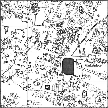
Central Chunchucmil. Note the density of residential groups defined by albarradas (stone fences) and streets, and the central marketplace.
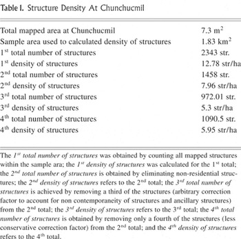
Structure Density At Chunchucmil
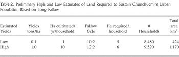
Preliminary High and Low Estimates of Land Required to Sustain Chunchucmil's Urban Population Based on Long Fallow

Phosphate Fractionation of Chunchucmil Soils (partly based on Beach 1998a)
 You have
Access