

The discovery of the hoard
In July of 2009 a metal detectorist, Mr Terry Herbert, made a startling discovery in a field in Staffordshire. The Staffordshire Hoard, as it came to be known, aroused international interest following the coroner’s inquest in September 2009 at which the discovery was first made known to the media. This short paper does not seek to tell the comprehensive story of the hoard; rather it seeks to outline the circumstances of the discovery and recovery of the hoard and to summarize its historical context.
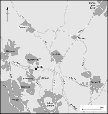
The findspot (fig 1) – adjoining the A5 Watling Street Roman road, approximately 3.5km to the west of Wall (the Roman settlement of Letocetum) – is now common knowledge. Positioned on the north-western spur of a ridge visible from the road within farmland that has been intermittently ploughed and laid to a variety of crops, at the time of the discovery the findspot was laid to horse pasture. Mr Herbert had obtained written permission to be on the land and had agreed in advance (again in writing) with the landowner that any financial reward gained from objects found would be divided equally.
Site location. Drawing: Nigel Dodds, © Birmingham Archaeology

After finding several gold objects on Sunday 5 July 2009, the finder told the landowner of his discovery and continued to detect in the area for another five days. During this time he recovered approximately 500 items, ranging in size from the cheek-piece of a helmet, a folded cross and numerous sword pommels, down to small strips of gold weighing less than one gramme. The finder correctly determined that the material was not coming from a surviving feature but was instead lying within the plough soil and sometimes on the surface. Duncan Slarke, the Portable Antiquities Scheme (PAS) officer for Staffordshire, was informed and he and the Principal Archaeologist agreed that this represented a significant hoard of Anglo-Saxon material. A meeting was therefore arranged at Birmingham Museum and Art Gallery (where the finds were being stored) to discuss an appropriate strategy.
The Methodology
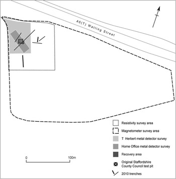
At this meeting, with Bill Klemperer, FSA, and Lisa Moffett of English Heritage present, it was determined that further exploratory work was required and it was agreed that Stephen Dean, Principal Archaeologist of Staffordshire County Council and a colleague, Ian Wykes, would undertake the excavation of a 1×1m test pit to identify whether further material was present and attempt to locate any associated archaeological features (fig 2). While this excavation was carried out, and with the permission of the landowner, the finder continued to detect the field and recovered several further impressive items. During the initial excavation a further one hundred items of gold, gold inlaid with garnets and of silver gilt were recovered from this one test pit alone, albeit the objects were small enough that all one hundred could fit into a small bag. Each find was individually bagged and its position recorded using a Global Positioning System.
The site: areas investigated. Drawing: Nigel Dodds, © Birmingham Archaeology

The excavation proved that further gold artefacts were present, all recovered from the topsoil (no artefacts were recovered from the subsoil) and that no features had been identified. It also became clear that there was minimal plough damage to the material and it seems that the artefacts had only been scattered from their deposition spot at the time of the last plough (autumn 2008). If so, it was considered that any feature associated with it may have been destroyed during that ploughing.
Birmingham Archaeology was commissioned to continue the work the following day, with the Principal Archaeologist continuing to monitor the work closely. After the initial test-pit excavation, a strategy was developed to investigate the field and recover remaining elements of the hoard in as systematic manner as possible. Staffordshire County Council prepared a Project Design for the investigation. English Heritage and Staffordshire County Council agreed to fund this work, with the Council funding on-site security during the night, because the threat from nighthawking was considered to be great on a highly visible site within a field bounded by roads on three sides, including the A5 Watling Street.
A total of 152sq m was hand-excavated. Each square metre was excavated by hand in spits, and the spoil repeatedly scanned with a metal detector, and sorted by hand, to maximize finds recovery. A magnetometer survey was undertaken during the hoard recovery to provide details of the archaeological context. The survey, comprising 5.3ha in extent, was undertaken using a Ferex 4.032 magnetometer. A selection of pit-type magnetometer anomalies were tested by hand-excavation. Outside the area excavated, systematic metal-detector surveys were undertaken, followed by hand-excavation of all potential signal locations.
The second stage of fieldwork, undertaken in March 2010,Footnote 1 was intended to provide an understanding of the immediate landscape context of the hoard. This fieldwork comprised a 1ha resistivity survey followed by trial-trenching and test-pitting to test the resistivity anomalies encountered. A line of test pits was also excavated across the natural ridge, to examine the topsoil and subsoil profile. All the excavated soil was scanned with a metal detector.
The Results
Careful hand-excavation in 1m squares resulted in the recovery of a total of approximately 800 objects, most of gold.Footnote 2 A few features, or possible features, were identified. None contained any datable finds, and none could be stratigraphically related to the hoard. The main excavated feature was a possible ditch (1007), aligned north west–south east, recorded in the extreme south-western corner of the excavated area. The ditch was cut to an irregular profile, and measured a maximum of 1.5m in width and 0.4m in depth. The ditch fills were orange-red sand-silt (1006) sealed by brown silt-sand (1005). The other excavated features comprised two possible post-holes (1016 and 1012) and a gully (1015 and 1013). The gully cut through backfilled feature 1007 and into the subsoil. The magnetometer survey demonstrated that the plough soil was heavily scarred by ploughing, aligned both east–west and north–south. The plough soil measured an average of 0.28m in depth.
Preliminary finds distribution plots have been prepared, based on provisional object identifications provided by Dr Kevin Leahy, FSA. Excluding the objects recovered from intact soil blocks (excavated at Birmingham Museum and Art Gallery), an area measuring 5m by 3m centred on the original discovery contained up to nineteen objects per square metre. Outside this area the artefact distributions were reduced, although not uniformly. By weight, the largest artefact collections were again located towards the original findspot. Outside this concentration the density was generally reduced, although a number of ‘hot spots’ were recorded. Interestingly, a number of the heavier items are located outside the centre of the hoard, either as a result of original placement or of being ‘dragged’ from their original location by ploughing. Overall, the smaller items may have remained where they were placed originally. The effect of ploughing in both east–west and north–south directions would be to enlarge the hoard scatter, in particular by ‘movement’ of the larger objects. The extent of the hoard scatter (90sq m) clearly refutes the suggestion that the hoard was buried only very recently, as may the suggested differential movement of smaller/lighter objects, as opposed to larger/heavier objects.
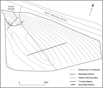
The main magnetometer anomaly was a curvilinear feature located towards the crest of the ridge, measuring 55m in length and 0.8–1.8m in width (fig 3). A feature mainly aligned north west–south east was also recorded, which correlates with a historic field boundary. Other, possible pit-type responses were also recorded. A possible anomaly aligned south west–north east corresponded, in part, with a slight ridge, visible as an above-ground earthwork.
The site: topography, trial trench locations and simplified plan of the main features. Drawing: Nigel Dodds, © Birmingham Archaeology

The main feature recorded in the March 2010 resistivity survey (fig 3) was a curvilinear anomaly, first recorded in the magnetometer survey. Trial-trenching revealed that this anomaly was a clay-filled feature, probably of natural origin. Trenches cut to the north east of the natural ridge revealed two palisade trenches cut to an irregular profile, aligned north east–south west and north west–south east. Neither contained any datable finds. Also recorded was a re-cut field boundary ditch. The other resistivity anomalies tested by trenching were found to correspond with variations in the natural subsoil.
Careful hand-sorting of the hand-excavated spoil, and repeated scanning of all machine and hand-dug spoil with a metal detector, failed to recover any finds, other than objects of recent date from these features.
Discussion
As suggested by the preliminary test-pit excavation, the hoard finds were located either within the topsoil or at the topsoil/subsoil interface. None of the features or possible features found during the recovery phase or the second fieldwork phase contained any datable finds. Originally the items were most probably placed in a pit dug in the ground, which has been totally ploughed out over time. Although comparatively little evidence of plough damage has been recorded, the recorded distribution suggests ploughing east–west and north–south has dragged many of the objects from their original location.
The curvilinear magnetometer and resistivity anomaly was recorded for a maximum length of 60m. It appeared to follow the orientation of the natural ridge. The other distinct magnetometer anomaly is the field boundary, aligned south east–north west and recorded in nineteenth-century OS mapping. Historic mapping shows this feature approximately following the brow of the natural ridge before curving to the north towards the northern field boundary adjoining Watling Street. It is possible that this change in direction could indicate that the field boundary was diverted from its course along the brow of the ridge in order to respect an existing feature, such as a belt of distinctive natural vegetation overlying the clay-filled feature of natural origin defined by the curvilinear magnetometer and resistivity anomaly.
Dr Ben Gearey has suggested that such a change in vegetation could have formed a prominent landscape feature, in particular because it followed the crest of the natural ridge. The placement of the hoard atop the north-western (lower) spur of the natural ridge suggests that a location adjoining Watling Street, in the proximity of this possible change in vegetation, was more important in the choice of burial site for the hoard, rather than burial on the higher land towards the south-eastern spur of the natural ridge.
Two conflicting interpretations of the hoard and its context have been suggested. One proposed that the hoard was buried hurriedly, with a view to recovery by individuals who did not survive to reclaim their treasure (heavier sword blades had already been removed before this). In this hypothesis, the topographic location of the hoard was chosen to facilitate its rediscovery. In the alternative hypothesis, the hoard is interpreted as an offering, in which case the topographic location may have held a symbolic meaning.
The two gullies excavated in March 2010 are difficult features to interpret in the absence of a chronological context. Although they were located in close proximity to the hoard, it may be significant that they were sited slightly downslope of the natural ridge, which could have provided protection from westerly winds. This location could suggest that the two palisade trenches formed part of a farmstead of either pre- or post-Roman date. The northernmost palisade trench was respected by the line of the curvilinear, north-western end of the historic field boundary.
The Metalwork
Most of the material found, initially over 1,600 objects, was of gold or silver alloy and represented what appear to be battle goods in a damaged state, including parts of possible decorative helmets, the remains of swords and decorative mounts, the blades of the swords and knives having been removed. Many of the objects had been damaged, possibly when collected following battle. A number of decorative gold mounts had held precious stones – probably garnets – which had been removed, although smaller items of delicate garnet cloisonné were intact. Other items were decorated with extremely fine filigree. Several crosses had been crumpled or folded; these included one large cross, one certain pendant cross, another smaller one and a possible cross arm with inscription.Footnote 3 There were no items of female apparel but also none of the military strap fittings that are common as male grave goods. The crosses, and perhaps the five small gold snakes found within the hoard (some with pins fitted), may have been worn or carried into battle as talismans. More than fifty blocks of earth were also recovered and these proved to contain further fragments of gold and silver, bringing the total number of pieces recovered to 3,940.Footnote 4
Precise dating of the objects is still uncertain but they fall within a date range from the mid-sixth to the early eighth century ad. Some of the artefacts bear a close resemblance in style to objects found at the Sutton Hoo burial site in Suffolk, which yielded graves and grave-goods that fell within the date range 550–650.Footnote 5 By the mid-seventh century, gold coinage was becoming debased, giving it a silvery tinge, and some of the items show this characteristic and so may have been derived from such a source, but the original sources of the gold, as for the garnets, has yet to be positively identified.Footnote 6 Other similarities to the Sutton Hoo material include the stylized animals that adorn some of the objects – animals resembling dogs bite the legs of others before them on a gold hilt plate; two eagles holding fish in their talons may have decorated a shield; others seem to have been on the cheek-piece of a helmet; one item seems to depict a horse – as well as the warriors depicted on a fragment of silver press fletched plate from a helmet.Footnote 7
The historical framework
The nature of the hoard and the reason for its burial at this location still remain uncertain. Whereas first impressions might suggest rapid burial beside the main Watling Street thoroughfare by those fleeing a military encounter, the nature of the material itself raises other possibilities. The objects, including about ninety-four richly decorated sword pommels, represent a careful selection that gives the impression that this is a ‘trophy hoard’ that may represent items collected over a period of time, rather than in a single battle.
There were several significant battles in the period when large numbers of aristocratic warriors would have been present. At this time the kingdom of Mercia was asserting its supremacy and waging war, particularly with the kingdom of Northumbria. Its pagan prince, Penda, later to become the ruler of Mercia, was aggressively extending his frontiers to the north, east and south, with notable battles at Hatfield Chase in Yorkshire (where, in 633, in alliance with Cadwallon of Gwynedd, Penda killed the Northumbrian king, Edwin) and another in 642 at Maserfelth, near Oswestry (where, in alliance this time with Cynddylan, prince of Powys, he killed Edwin’s successor, Oswald), and many others. Bede says he also killed the leaders of the East Angles in c 635,Footnote 8 in the form of the retired king Sigeberht and his successor, Ecgric, descendants of Raedwald, who some believe was buried at Sutton Hoo. Penda was either killed or fatally wounded by the Northumbrian king Oswiu at the battle of Winwaed (not identified) in 655. There was further conflict between Northumbria and Penda’s successors in Mercia later in the seventh century.
Welsh poetic sources also refer to further battles at about this time, one of which is said to have taken place in the Lichfield area. The Marwnad Cynddylan tells of a raid upon Caer Lwytgoed by the men of Powys under a leader called Morfael, in which they took ‘extreme booty’:
Maured gymined mawr ysgafael
y rhag Caer Luitcoed neus dug moriael
Pymtheccant muhyn a phum gwriael
pedwar vgeinmeirch a seirch cychafael
The greatness of swordplay – great booty –
before Lichfield Morfael took it:
fifteen-hundred head of cattle and five? …
eighty horses, and harnesses ?besides.Footnote 9
This poem has traditionally been interpreted as an attack by the men of Powys on monks established in the vicinity of Lichfield.Footnote 10 Letocetum (*leito-, Welsh llwyd) was the name of the small Roman town and fort at Wall. Both it and Lwytcoed (PrWelsh *Luitged or Letged) mean ‘the grey wood’, while in the eighth century Lichfield is called Anliccitfelda and Lyccidfelth, ‘the open land at or called Lyccid’.Footnote 11 The name Lwytgoed may have referred to the district – perhaps as a forest name applied to an extensive area of woodland stretching from Wall to Lichfield.Footnote 12 The identification of Caer Lwytgoed appears to contain the PrWelsh cair element, suggesting a defensive wall or rampart, and it is for this reason that some have identified this with what remained of Roman Letocetum at Wall, and why several scholars have suggested that the monks were actually located there, rather than at Lichfield, perhaps as a surviving Christian community. There is evidence for Christianity here in the late Romano-British period in the form of a chi-rho symbol found on a bronze bowl and a stone fragment with a carved cross,Footnote 13 but the site of the monastery remains unknown and nothing has been found archaeologically to site it at Wall.
Until recently, very little was known about settlement at Lichfield before the days of Chad, and the Life of Bishop Wilfrid simply refers to the site of the bishopric being established at a locus (‘place’) in 669.Footnote 14 The recent discovery of a substantial sub-Roman building (destroyed by fire) within Lichfield town, however, and later Grubenhäuser above (also destroyed by fire), indicate pre-Chad settlement on the site. A new church was built at Lichfield on the present cathedral site in the late seventh/early eighth century and Chad’s remains incorporated within it. As for the perpetrators of the attack, Rowland has suggested that the men of Powys were actually supporting Cadwallon of Gwynedd and Penda against a Northumbrian enemy. She argues that the monks referred to were serving the religious needs of a Northumbrian army.Footnote 15
Although the items found in the hoard appear to be both military and masculine, Brooks has made the alternative suggestion that the hoard represented items collected as tribute – although their damaged state may conflict with this suggestion.Footnote 16 Nothing, however, clarifies the reason for their deposition, nor their deposition in this particular place. An interesting comparison may be made with events recorded in the Old English poem Beowulf, thought to have been composed in Mercia. This describes the ritual deposit of golden objects taken from a barrow protected by a dragon and buried with the Anglo-Saxon leader after he had been fatally wounded by the dragon:
Hi on beorg dydon beg ond siglu,
eall swylce hyrsta, swylce on horde ær
niðhedige men genumen hæfdon;
forleton eorla gestreon eorðan healdan,
gold on greote, þær hit nu gen lifað
eldum swa unnyt swa hit æror wæs.
In the barrow they placed rings and brooches,
all such trappings as men disposed to strife
had earlier taken from the hoard;
they let the earth keep the warriors’ treasure,
gold in the dust, where it still remains now,
as useless to men as it was before.Footnote 17
Leslie Webster has also commented upon the narrative of Beowulf being ‘led by the need to consign the ill-gotten treasure back to earth’.Footnote 18 In the case of Beowulf, the treasure was made up of grave goods stolen from a barrow: ‘gold, which in the end, brought grief’.Footnote 19 Although the findspot was a ridge top, no surviving barrow was present in this case; nor was there evidence of burial or of ritual. No archaeological feature explains the choice of this particular spot and no pagan shrine is known in the area. The place-names Wednesbury and Wednesfield seem to attest to a Wōden cult lingering in the area of the South Staffordshire Plateau and the presence of a heathen temple further along Watling Street to the east is suggested by the place-name Weeford, incorporating Old English weoh ‘pagan temple’ with ‘ford’ (but the ford cannot have been crossed by Watling Street).Footnote 20 Although many such centres occupied hill-top positions, no place-name evidence exists that draws attention to this particular findspot.
The wider landscape context
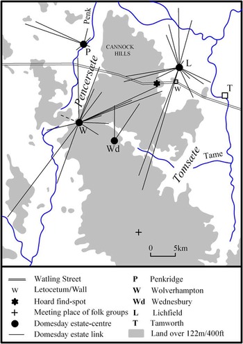
The hoard was located on the brow of a natural ridge adjoining Watling Street in Ogley Hay. Watling Street was the main thoroughfare through this area, although Roman Ryknield Street also ran from the south to join Watling Street at Wall.Footnote 21 Fieldwork in Hammerwich has suggested that this section of Watling Street remained in use into the Anglo-Saxon and medieval periods.Footnote 22 Indeed, Watling Street is likely to have been the most obvious feature in this locality, for place-name and documentary evidence all suggest that this was a sparsely populated region of woodland and heathland in the early medieval period. High land ran from north to south, linking the Cannock Hills to the Birmingham Plateau. The high land appears to have divided two major territories – that of the Tomsæte, established in the Tame valley to the east, and the Pencersæte, established in the valley of the River Penk. These groups are recorded in a mid-ninth-century Worcestershire charter of Alvechurch and Cofton Hackett, in which their lands are said to have met on the Birmingham Plateau to the south of the later county boundary (fig 4).Footnote 23 The ribbon of high land was obviously a marginal zone but this environment is likely to have provided valuable wood and timber resources and wood pasture for domestic livestock. Wood pasture was especially valuable in the early medieval period, with acorns providing forage for herds of swine in the autumn. Indeed, swinefolds are recorded on the boundaries of both Wednesfield and Ogley Hay in the spurious foundation charter of Wolverhampton minster (see below).
Folk groups and linked estates in south Staffordshire. Drawing: D Hooke

Estate linkages recorded in the Domesday Book clearly show estate centres holding dependent vills to the west and east of the high land in this region, estates that probably began as holdings of seasonal pasture in this marginal zone. To the east, Lichfield had become the centre of a late seventh-century bishopric, not far distant from the Roman centre of Wall. Its dependencies spread westwards into this region to include ‘the two Hammerwiches’ and Wyrley. To the west lay two estate centres: the royal vill of Wednesbury with links northwards to Bloxwich and Shelfield, and Wolverhampton, where a minster had been (?re-)established by Wulfrun in 994. The estates of the minster often lay at a considerable distance and in this region included Ocgintun/Ogintune (Ogley) and Hilton, almost interlocking with the Lichfield estates. It seems that the northern boundary of the Hwiccan kingdom may have been pushed northwards in the early medieval period, after which the royal centre of Bromsgrove was also able to claim dependent holdings on the Birmingham Plateau to the north of the earlier line.Footnote 24 The date at which estate boundaries became stable in this area is not known but would appear to pre-date Domesday Book; an Old English boundary clause of Ocgintun is attached to the spurious alleged foundation charter of Wolverhampton minster.Footnote 25 The compilers of this charter may have made use of genuine sets of pre-Conquest bounds that were in their possession when the charter was forged. In Domesday Book Lichfield’s holdings in this area (Packington, the two Hammerwiches, Stychbrook, Norton (Canes), Wyrley and Rowley), together with Wolverhampton’s holding at Ogley, were all described as ‘waste’, probably implying that they had already been taken into Cannock Forest.
Routeways linked the dependent vills to their home estates and one of these ran from Wolverhampton directly to Watling Street close to the hoard location site.Footnote 26 It ran through Wednesfield as the alde stret (‘old street’), the use of the Old English term stræ¯t suggesting a road of some importance; however, it seems that this same route was known simply as the Hunten stye (‘hunter’s path’) by the time it reached Pelsall. Another route appears to have crossed Watling Street to the west of the junction of these two routeways to run south-eastwards to the Ryknield Street (the later ‘Chester Road’, now the A452) but in later times another north-west–south-east road also crossed Watling Street further to the east. If this had been an early route it may have left the site spot in a kind of ‘no man’s land’ on the waste. Another hillock beside the Watling Street, other than that on which the hoard was found, attracted attention in the late seventeenth century. This was ‘Knaves Castle’, first recorded c 1308.Footnote 27 It was a low, tumulus-like mound, just over 1km to the west of the findspot (although the Ogley Hay Inclosure map of 1838 shows a square moated feature).Footnote 28 Traditionally, it was associated with travellers crossing the heath and may have been renowned as a spot used by highwaymen and thieves, but when road widening was carried out in 1971, no sign of any barrow ditch was found and it was concluded that the feature was probably natural.Footnote 29 If it is indeed derived from OE hlaw (‘tumulus’), the name Catteslowe, recorded in the bounds of the hay of Ogley in 1300, later Catshill, may suggest the presence of a former tumulus beside the Old Chester Road, perhaps even one associated with Anglo-Saxon burial.Footnote 30
Habitative place-names recorded before 1086 are clearly concentrated in the riverine corridors of the Tame, with a thinner scatter over the high land, while lēah-type names indicative of a wood pasture environment are more frequent over the high land. Areas apparently empty of early names, such as the Cannock Hills, do not conflict with this distribution but merely indicate that settlement names of any kind were relatively few in such an undeveloped area. The names of Wednesbury and Wednesfield, referring to the god ‘Wōden’, may indicate an area of lingering pagan belief in the south of the area (the Mercian king Penda remained staunchly pagan until his death in 655). It may be a coincidence that two settlements in the vicinity of the findspot were the Lichfield dependencies of the ‘two Hammerwiches’, names derived from OE hamor with wīc (‘the hammer working or trading place’),Footnote 31 and while wīc does not necessarily indicate a centre of importance (numerous ‘cheese’ and ‘herding’ wīcs, for example, seem to have been little more than places at which some specialized function was carried out), it does in this instance seem to indicate an association with metal working. While there have been other finds of metalwork in the district, including a gold and garnet pendant found within the parish in 2004 and a copper-alloy object found in the same field as the hoard, there is no known direct link to the hoard itself and the site does not appear to represent a ‘productive site’ in the sense of a rural area of market activity. The nature of the material found in the hoard suggests a far more specialized assemblage – the material was no casual accumulation. Moreover, the number and range of objects suggest an elite association rather than a productive site. The only other similar wīc site noted in south Staffordshire is another Lichfield dependency to the south: Smethwick ‘the smith’s wīc’, also recorded in 1086 (no Anglo-Saxon metalwork has, however, been found here). The smiths of Hammerwich may have made use of the quantities of charcoal available in this area. The majority of the wīcs in south Staffordshire and north Worcestershire can be identified as dependent settlements attached, often at a considerable distance, to an estate centre: Hammerwich and Smethwick to Lichfield; Bloxwich to Wednesbury; Eswich (?Ashwood) to Wolverhampton; Wightwick to Tettenhall, and Willingewic and Chadwick to Bromsgrove.
The nature of the landscape in this region changed little in the later medieval period. The Ogintune of the Wolverhampton charter was almost always referred to merely as Ogley, and it was an extra-parochial area that remained a ‘hay’ of Cannock Forest throughout the medieval period. Forest records confirm a typical ‘forest’ landscape of open heathland interspersed with woods: in 1235 the wood of Ogley was described as ‘well kept in respect of oak’. There were the usual presentments at the forest courts for the illegal felling of trees here, occasional illegal encroachments and many for the illegal poaching of venison, sometimes by the foresters themselves.Footnote 32 The hays were the last remnants of the forest which, when it had ceased to function as a royal hunting ground, passed to various manorial lords. By the seventeenth century, lodges and warrens had been established in many places but large areas, including the entire extra-parochial area of Ogley Hay and a large sector of Hammerwich parish, remained unenclosed until the middle of the nineteenth century. Throughout history, therefore, development was sparse over much of the area, something which no doubt helped to preserve the hoard site from earlier destruction.
Conclusion
The Staffordshire Hoard site lay beside a major thoroughfare within the heart of Mercia, a kingdom that was coming to the fore in the seventh century. It lay in a region of high marginal land dividing two major territories. It also lay close to a boundary dividing the dependent holdings of different estate centres. We do not know whether the liminal character of the site is significant; more likely to have been influential on the choice of the site was its proximity to the Roman Watling Street. Further artefact research, in tandem with study of the landscape context, should provide a better understanding of this unparalleled Anglo-Saxon gold hoard. Whatever the final interpretation of the hoard is, it will undoubtedly rewrite our knowledge of Mercian history.
ABBREVIATIONS AND BIBLIOGRAPHY
- Abbreviations
- NLWNational Library of Wales, Aberystwyth
- SROStafford Record Office
- Manuscript sources
- NLW, ms 4973
- SRO, Q/RDc/90 (Ogley Hay Inclosure Plan and Award 1838)