


1. INTRODUCTION
Uneven deployment and high rates of failure characterise policy implementation in developing economies (Hirschman Reference Hirschman1963). This is typically the case in the construction of physical and social infrastructure (Williams Reference Williams2017), but redistributive policies might also suffer from uneven deployment, poor targeting and incompleteness (Bardhan and Mookherjee Reference Bardhan and Mookherjee2010; Brown et al. Reference Brown, Ravallion and Van De Walle2018).
Many developing economies are largely agrarian, where the main policies for redistribution are land reform and interventions in land and rural labour markets. Land reform has a long history of failure and partial implementation (Albertus Reference Albertus2015). Firstly, land re-distribution can cause an authoritarian reaction typically leading to democratic breakdowns or civil war (Luebbert Reference Luebbert1991; Acemoglu and Robinson Reference Acemoglu and Robinson2006). Secondly, powerful landlords can block or delay reform (Albertus and Kaplan Reference Albertus and Kaplan2012; Finkel et al. Reference Finkel, Gehlbach and Olsen2015; Albertus et al. Reference Albertus, Brambor and Ceneviva2016). Thirdly, reformers may have inadequate and incomplete technical and statistical information on the working of the rural economy and limited administrative capacities (Hirschman Reference Hirschman1963; Scott Reference Scott1998). Finally, in contexts with some level of separation of executive and judicial powers, judicial protection of property rights can slow down reform (Albertus Reference Albertus2015; Domenech and Herreros Reference Domenech and Herreros2018).
However, in some cases, uneven and slow deployment of land reform can be overcome by local, bottom-up forces. ‘Reform from below’ can incorporate the organised local peasantry, even in a very disorganised fashion, substituting for homogeneous, top-down policy designs (Lipton, Reference Lipton2009, pp.60-62). Typically, local collective action can be a source of information for poorly informed, low capacity states not knowing where and how to deploy land reform adapted to local conditions (González and Vial Reference González and Vial2019). In addition, locally organised peasants can resist powerful landlords, contributing to deploy reform where the state is weak (Lipton, Reference Lipton2009, p. 62, Finkel et al., Reference Finkel, Gehlbach and Olsen2015). Competing social movements can also accelerate reform for strategic reasons by distributing private goods such as jobs or land to their members (Domenech Reference Domenech2013; Percoco, Reference Percoco2017). Finally, local militancy can force the state to accelerate redistribution to avert costly social conflict (Acemoglu and Robinson Reference Acemoglu and Robinson2006; López-Uribe Reference López-Uribe2019).
All in all, although collective peasant action can accelerate land reform, it is highly possible that ‘reform from below’ increases the heterogeneity of policy implementation. In contexts in which policy deployment depends on local organisational capacities, policy implementation can also vary spatially and will not be fully targeted to all eligible, potential beneficiaries. Structural conditions –– inequality, poverty, etc.–– might be similar across one region, but there could be large variations in local collective action that could increase spatial variation in redistributive intensity.
In this paper, we study land reform in 1930s Spain as a case of discretionary deployment of land reform in the context of a still predominantly agrarian and semi-industrialised country with limited levels of state capacity. We focus on the case of Extremadura because, although there were sizeable spatial differences, land invasions accelerated land reform in 1932-1933 and later in 1936, which meant that Extremadura was the only region in Spain in which land reform was seriously implemented in the 1930s. The traditional historical literature, by concentrating on the unfairness of land ownership patterns and the poverty of landless workers, sees land invasions as an only natural decision of poor, desperate masses of landless workers (Tuñón de Lara Reference Tuñón De Lara1985, p. 176; Riesco Reference Riesco2006, p. 300, p. 303; Espinosa Reference Espinosa2007, p. 125). Those landless peasants could on their own execute land reform despite the strong opposition of landowners was even believed at the highest levels of the Republican-Socialist government.Footnote 1
Despite these views, our assessment of land reform deployment in Extremadura re-balances the explanation of fast land reform in the region to stress its interaction with the top-down, overarching policy objectives of Republican governments. We downplay somehow the role of local unions and local conflict in accelerating land reform. In particular, we find that temporary settlements closely tracked the local stock of expropriable area and the presence of farms owned by Grandes de España, the most important aristocratic families in Spain whose special status had been abolished by the Republican government. Although temporary settlements followed localised collective action, they were quickly transformed into a programmatic policy to accelerate land reform to meet complementary objectives. In this sense, we do not find 1933 settlements were qualitatively different from the allegedly more revolutionary land invasions of 1936. We argue that programmatic policies aimed at settling as many peasants as possible on abundant land were as important as local collective action in the province of Badajoz and more important than local collective action in that of Cáceres.
In relation to the existing historiography, our argument re-balances the main explanatory factors explaining quick land reform in the south-west of Spain in favour of greater importance of programmatic, top-down objectives. Although spontaneous land invasions no doubt were part and parcel of land reform, settlements followed relatively simple, universalistic rules of temporary expropriating land to settle as many peasants as possible in municipalities with abundant expropriable land.Footnote 2
We, therefore, stress the programmatic concerns of the Republican-Socialist coalition over purely local factors when explaining land invasions in Extremadura. From the point of view of the government, the dual fight against rural poverty and Grandee families stemmed from the need to stabilise the young Republic. There had been a serious military coup in August 1932 and there were several Anarchist riots in various parts of the country (e.g. in the case of Andalusia, see Macarro, Reference Macarro2000). A first objective was mitigating rural poverty to moderate landless peasants’ revolutionary preferences, which the government thought were quickly veering towards Anarchism and Communism. A second objective was the political battle against Grandee Aristocracy, a cohesive and powerful group opposing democracy and the Republic. These objectives were particularly complementary in Extremadura, the area of Spain in which Grandees owned most land. In other provinces, the landholdings of Grandeza were vastly overestimated (Fraser Reference Fraser1979, p. 514). All in all, rather than agreeing with the historiography that poor, landless rural masses radicalised an originally moderate land reform in Extremadura, we stress exactly the opposite: Republican governments radicalised land reform to stabilise the Republic.
The paper is organised as follows. In section 2, we provide some historical background, introduce land reform in Republican Spain and the importance of ‘temporary’ settlements under the decree of intensification of cultivation. In section 3, we document the high degree of variation in the more discretionary measure of temporary settlements, as well as some of its potential drivers. In section 4, we systematically analyse its correlates and provide some interpretations. In section 5, we discuss the diffusion of the short-lived settlements of March-July 1936. Section 6 presents some conclusions.
2. LAND REFORM IN 1930S SPAIN and TEMPORARY LAND SEIZURES
In 1930, agriculture was still an important sector in Spain's economy, employing about half of the gainfully employed. Because some parts of the country had a very unequal distribution of land ownership, landlessness and rural poverty were a widespread phenomenon. Many landless peasants were rural labourers underemployed for long stretches of time, or tenants with little bargaining power. As a result, although there had been serious improvements in the access to ownership, in 1930 Spain still had about a million landless rural labourers, out of almost 4 million gainfully occupied in the sector (Carmona et al., Reference Carmona, Rosés and Simpson2019, p. 676).
Given widespread rural poverty and inequality, many interwar democracies enshrined the «social» uses of land and other assets in new constitutions and changed property rights legislation accordingly. In 1930s Spain, the very first of such attempts are found immediately after the regime change on 14 April 1931. The provisional Republican government issued decrees suspending the eviction of tenants (29 April 1931) and giving local authorities major intervention powers in local rural labour and tenancy markets (11 July 1931—reducción de rentas) or imposing upon landowners minimum levels of agricultural employment (8 May 1931- laboreo forzoso). The government also legislated on region-specific rural contracts (foros in Galicia).
In September 1932, parliament passed an ambitious land reform law, which targeted the highly unequal distribution of land in the provinces south of Madrid, especially in south-western Spain. The law established maximum size thresholds for farms, above which land was to be expropriated and given to landless peasants. There were other important criteria such as the expropriation of lands that had been leased for 12 years of more or were inefficiently cultivated or not irrigated. Expropriated owners were to receive compensations equivalent to the cadastral value of land, except for cases in which they belonged to important aristocratic lineages, the so-called Grandes de España. The involvement of several of these noblemen in a failed coup in August 1932 provided the government with the political muscle (and legal basis) to include expropriation without compensation of an easily targeted group of large landowners just before passing the law.
The consensus in the historical literature since Malefakis (Reference Malefakis1970) is that land reform was a failure, as only a small proportion of lands were expropriated and given to landless peasants. Because Spanish reformers had only a superficial knowledge of land ownership patterns in the countryside, they were under the illusion that they could settle a large share of the landless on the expropriated lands of the Grandeza. However, land ownership patterns were far more complex than expected and the costs of expropriating lands much higher than anticipated. Not only did non-Grandeza owners need to be compensated, but long-term tenants managing the farms of large owners and then sub-letting them to smaller tenants were also eligible for compensation. Implementing such a formidable reform agenda was entrusted to a newly founded body, the Land Reform Institute (IRA in its Spanish acronym), whose administrative capacity had to be built from scratch. Finally, the outcome of the November 1933 general election shifted policy to the right, especially after October 1934, weakening the political will to deploy land reform.
Given the glacial pace of reform, other measures took pre-eminence. This was especially the case of the so-called decrees of intensification, aimed at exploiting more intensively lands in land-abundant regions with extensive methods of production, long fallow cycles and mixed uses of land (husbandry, forests and the like). This was especially to be deployed in Extremadura, and more hesitantly in municipalities in the provinces of Salamanca, Toledo and Ciudad Real in Castile, and some Andalusian provinces (first several municipalities in Cádiz and Seville, and in 1936 in municipalities in the uplands of Córdoba). This formula entailed the temporary seizure of land and the payment of monthly rent to the owners of the land based on the cadastral value of confiscated land. Intensification plans were to be drawn up for municipalities with an acute unemployment crisis and were deployed in principle with the assistance of the IRA. The decree also allowed peasants from one municipality to settle in other municipalities. The decree of intensification of cultivation was passed on 23 October 1932. Initially, circumscribed to the province of Badajoz only, in early November the decree was extended to the provinces of Málaga, Sevilla, Granada, Cádiz and Cáceres. Given their nature, the measures of the decree of intensification of cultivation allowed authorities to by-pass administrative, legal and financial obstacles to full land reform as originally envisaged.
In mid-November 1932, Luis Peña Novo became the Prefect of the whole region of Extremadura, with one of his mandates being the deployment of the decree of intensification of cultivation (Gaceta de Madrid, 342, 7 December 1932). He met, however, the stern opposition of landowners, who claimed that the intensification of cultivation endangered livestock farming in Extremadura. As a result, the governmental sanctioning of settlement plans based on petitions from municipalities was suspended and more rigorous controls by the Ministry of Agriculture were imposed.
The contracts of these temporary seizures and settlements were written to expire on the 30 September 1934 (Riesco Reference Riesco, Robledo and López2009). With a Rightist but reformist Minister of Agriculture, the Giménez Fernández law of 21 December 1934 rolled over the contracts until 31 July 1935. After this date, yunteros were technically evicted, although it is impossible to know the extent of evictions, the qualitative (probably biased) evidence suggests that thousands were evicted.Footnote 3 When the Popular Front won the February 1936 election one of the main objectives was to accelerate land reform. The Popular Front Minister of Agriculture Ruiz Funes passed a decree reinstating the settlements of yunteros (Gaceta de Madrid, 65, 5 March 1936, pp. 1849-1850). In late March 1936, a much wider wave of land invasions by yunteros swept Badajoz and Cáceres.
Most of the lands invaded in Extremadura were already cultivated in 4-year-long rotations. In Cáceres, the Bulletin of the IRA mentioned, in April 1936, what sort of lands were invaded in the first flush of invasions (probably March). According to this source, at the time 71,439 ha were given to yunteros in Cáceres. Of those, about 50,000 were lands already used for cultivation (hojas de labor) and the rest, around 21,500 ha, were lands whose use had to be shifted from pasture/husbandry to agriculture. This was a tiny proportion of the more than a million hectares devoted to pasture and other uses in Cáceres (BIRA, 46, p. 353).
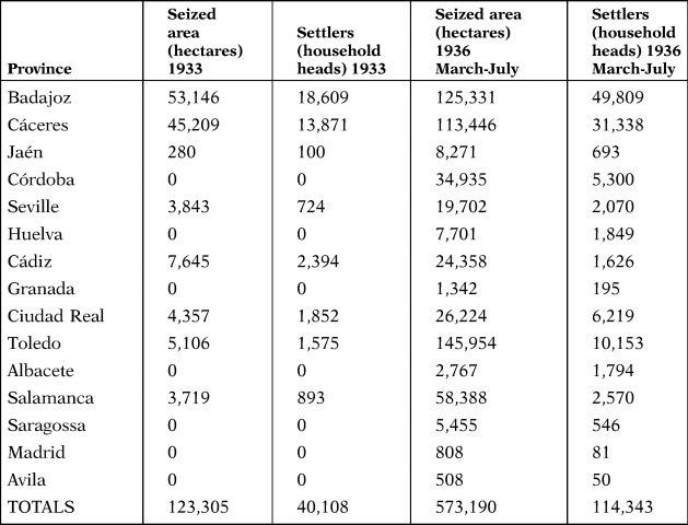
Table 1 shows how temporary settlements were a partial solution to the problem of landlessness. According to estimates by Carmona et al. (Reference Carmona, Rosés and Simpson2019, p. 676), Spain had around 570,000 landless peasants in the provinces affected by land reform (and slightly below 1 million overall in Spain). In the 1933 land occupations, only 7 per cent of the landless in reform-provinces were temporarily settled. This ratio reached 20 per cent in 1936 in reform-affected provinces. In the provinces with more settlers, in Badajoz and Cáceres, close to 65 per cent of the Peasant Census was settled in 1936: in Badajoz, 49,809 household heads out of 78,513 eligible household heads, in Cáceres, 31,338 out of 49,830.
AREA SEIZED AND SETTLED PEASANTS, INTENSIFICATION OF CULTIVATION DECREES, 1933 AND 1936

Source: Adapted from Malefakis (Reference Malefakis1970), p. 242 (Table 30), p. 378 (Table 37).
We can only approximate the depth of the intervention in relation to farms affected by land reform. In Badajoz, farms above 250 ha covered 861,602 ha (Carrión, Reference Carrión1975, p. 186), and there were 667,348 ha of lands affected by agrarian reform included in the Registry of Expropriable Property (Robledo Reference Robledo and González De Molina2014, p. 91). In Badajoz, therefore, less than 8 per cent of the area covered by farms affected by land reform was temporarily seized in 1933. The percentage seized increased to 20 per cent in 1936. The same calculation carried out for Cáceres gives 9 per cent in 1933 and 23 per cent in 1936. In the rest of the provinces, the percentage of seized lands relative to the pool of lands affected by land reform was below 10 per cent in 1936.
Did settlements vary in intensity? A way of approaching the intensive margin of settlements is to consider the number of settled peasants relative to the local census of landless peasants, combining information on the number of settlers in each municipality with data on the number classified as rural labourers, tenants and owners of small plots according to the Peasant Census (Censo de Campesinos, Brel and González, Reference Brel, González, Dios, Infante and Torijano2013). This was a census carried out by local unions and the local council and sent to the Institute of Agrarian Reform. The census was first drawn up in 1933 and was later corrected until 1935 or 1936. There are two serious problems when using this census. First, it was compiled around the time of settlements and later amended in many municipalities. Second, about 25 per cent of municipalities in Extremadura did not assemble a peasant census at all. There are no obvious reasons for this. Municipalities with no Peasant Census were not smaller, not less populous, or more isolated municipalities. For example, political participation in the 1931, 1933 and 1936 general elections was roughly similar in both groups of municipalities (with and without Peasant Census). However, although using the Peasant Census is problematic, it is the only source we have for information on social structure in the countryside at the local level.
There are some extreme values when looking at the targeting of the eligible poor, mostly landless peasants. In 1936, 14 out of 237 municipalities with settlements reported a ratio of settled to eligible above 1, in some cases as high as 4.2. For municipalities having settled to eligible ratios below or equal to 1, the average targeting was 0.44 in 1933 and 0.49 in 1936. However, these numbers might be biased downwards by the inclusion of some municipalities whose rural poor were settled in other municipalities.
Critics of 1930s land reform have argued that allotted lands were insufficient to sustain a family. Various estimates suggest that in the climatic and soil conditions of southern Spain, only farms around 10 ha or more could sustain a family (López Ontiveros and Mata Olmo Reference López Ontiveros and Mata Olmo1993, p. 145; Carmona and Simpson Reference Carmona and Simpson2017, p. 8). In 1933, average plot sizes in occupied lands were below 3 ha in Badajoz and Cáceres. In the municipalities having settlements sanctioned by prefect Peña Novo, less than 2 ha were given on average to settlers (N = 63). This is less than half the estimated plot sizes for settlers in Córdoba, around 5.5 ha, which were considered too small by the IRA experts deployed in the province (López Ontiveros and Mata Olmo Reference López Ontiveros and Mata Olmo1993, p. 90).
Some high-quality studies provide some scattered evidence on the operation of settlements. López Ontiveros and Mata Olmo (Reference López Ontiveros and Mata Olmo1993) argued average plot sizes in the settlements of Córdoba were too small (around 7-8 ha) to solve the chronic problem of excess labour supply (López Ontiveros and Mata Olmo Reference López Ontiveros and Mata Olmo1993, pp. 146-147). Sígler (Reference Sígler2000) provides a very detailed and, by and large, negative account of the operation of temporary settlements in Espera (Cádiz), on three farms covering 1,620 ha expropriated from Grandeza (Sígler Reference Sígler2000, pp. 85-87; BIRA 16, p. 60; BIRA, 21, p. 174-175). Ruiz-Castillo (Reference Ruiz-Castillo1972), a civil servant of the IRA, provided an optimistic but very impressionistic account of their operation there (Ruiz-Castillo Reference Ruiz-Castillo1972, pp. 125-126). Carmona and Simpson (Reference Carmona and Simpson2015a) discuss the settlement of «La Pulgosa» in the province of Badajoz arguing that the small farm sizes and difficulties in intensifying production in most plots frustrated the expectations of alleviating poverty, especially because farms were too small to guarantee full employment throughout the year (Carmona and Simpson Reference Carmona and Simpson2015a, p. 28, see also Carmona and Simpson Reference Carmona and Simpson2016).
What sort of land was given to settlers? According to the IRA, around 70 per cent was fallow land that belonged to the 4-year rotations and that had probably been prepared by other yunteros or by the settlers themselves. Only 30 per cent was land not ready for immediate cultivation that probably had previous uses, generally, grass lands with trees that could be extensively used for pasture (BIRA, 46, p. 353).AQ: Please check and confirm the edit made to the sentence ‘…with trees that could be extensively used for pasture’ is appropriate. Given that not much land was redistributed and that pastoral activities were very land-intensive, the share of land used to graze animals or exploit forest resources (wood, cork, acorns) that shifted to more land-intensive agricultural activities was actually very small. According to the IRA in the broader seizures of April 1936, only 21,439 ha in Extremadura were new agricultural lands previously devoted to alternative uses. The total area of land under various uses other than agriculture was 1,082,870 ha. Therefore, the IRA was shifting less than 2 per cent of lands with pastoral and forest uses towards more labour-intensive agriculture (BIRA, 46, p. 353). Most of the land given to Extremadura's settlers consisted of plots in the 4-year-long rotations that could readily be planted (a more detailed explanation in Carmona and Simpson, Reference Carmona and Simpson2016, pp. 137-138).
Another crucial variable is the amount of financial support per settler, which adds a further dimension to the deployment of the policy. For example, the loans disbursed before April 1933 varied between 0 and 722 pesetas in the municipalities having settlement plans approved up to April 1933 (N = 135). In the 55 municipalities receiving a loan before April 1933, the average loan per settled family was 163 pesetas, but this varied from 18.19 to 723. Given this variation, we will explore the role of disbursed loans.
In this study, we use local information on temporary land seizures, number of settlers and loans published in the monthly Bulletins of the Institute of Agrarian Reform in 1933 and 1936. This source summarises IRA settlement plans in each municipality (Expedientes de intensificación de cultivos) and has been widely accepted and used by social and economic historians of agrarian reform. The plans generally included the farms that were to be expropriated, the number of peasants to be settled, and the loans earmarked for each settlement plan (BIRA, 1933, 16, pp. 52-58). There is no evidence of loans for several municipalities with settlement plans. This is especially the case of 13 of the 16 municipalities in Cáceres with IRA settlement plans (BIRA, 16, p. 54) or the municipalities with settlement plans directly sanctioned by the Prefect General of Extremadura (BIRA, 16, p. 58-59). The 1936 Bulletins give information for areas seized and numbers of settlers in 1936 (BIRA, 45, pp. 214-226; BIRA 46, pp. 341-348; BIRA 47, pp. 507-13; BIRA, 48, pp. 748-758, BIRA 49, pp. 123-127), but information on loans is absent. The IRA, however, had a large budget for this end; 33 million pesetas were earmarked to cover the fixed and variable costs of the settlements, to which several other contingency funds totalling 43 million pesetas were added. The total budget for the support of settlers was therefore 76 million pesetas (BIRA, 43, pp. 25-27).
In addition, the April 1933 Bulletin gave information on loans disbursed to either local peasant unions or local councils up to the 31 March 1933 (BIRA, 16, pp. 60-61). These included loans to 97 settlement communities (managed by unions or local councils) totalling almost 4 million pesetas (the total budget of the Ministry of Agriculture, Industry and Trade, in charge of deploying the reform, was 113 million pesetas, Comín and Díaz, Reference Comín, Díaz, Carreras and Tafunell2005, p. 934). Of the 97 plans receiving rapid financial support, 53 were in the province of Badajoz, with loans totalling 2.5 million pesetas, while only 74,000 pesetas were granted to three settlement communities in Cáceres.
Furthermore, the Bulletin also gave a brief description of the operation of settlements, circumscribed in most cases to the province of Badajoz. The report detailed how 57 municipalities (out of the 168 municipalities of the province) had settlement plans involving a total of 18,943 settlers and the seizure of 53,035 ha of land, with an average of 3 ha given to each family (the unit here is one household head). The IRA calculated that settlers in Badajoz needed 10,234,509 pesetas, (514 pesetas per household head or 193 pesetas per hectare), which were to be given in three instalments (BIRA, 16, p. 62).Footnote 4 In total 43 out of 57 municipalities had received early relief loans in March and April.
The description suggests the timing of implementation was crucial because settlement plans needed to start before the planting season. In particular, 500 ha had settlements postponed because the plan had arrived too late for planting. For the remaining lands, the IRA probably painted an excessively rosy picture of the uses of land on the seized farms, suggesting fallow land was used to plant chickpeas or watermelons. According to this source, 8,000 ha of chickpeas were planted, along with maize, melons and watermelons. The last two were not profitable but contributed to the fertilisation of soils in preparation for the next year's wheat crop (BIRA, 16, p. 63).
Finally, we also have information on the timing of approval of settlement plans (the day on which the settlement plan was passed), which we consider a proxy of the day on which the IRA elevated the settlement plan to the council of ministers (El Socialista gave the exact day on which the council of ministers approved the plan). The timing of the settlement plan provides extra variation that can help us understand some of the drivers of heterogeneity in local land reform deployment.
3. WHAT EXPLAINS THE INTENSIFICATION OF CULTIVATION PLANS OF 1932-1933?
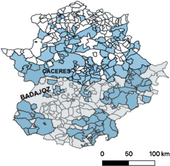
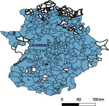
In this section, we analyse the spatial variation in 1932-1933 temporary settlement plans under the intensification of cultivation decrees. Badajoz had all of its settlement plans organised as expedientes de intensificación de cultivos elevated by the IRA to the government and later to Parliament, whereas Cáceres combined cases prepared by the IRA and those started by the general Prefect of Extremadura, Luis Peña Novo. In addition, we will also look at other dimensions of policy deployment by investigating the timing of approval of settlement plans and the disbursement of loans to settlers through local peasant unions. Figure 1 displays the spatial variation in temporary settlements in the two provinces.
MUNICIPALITIES WITH SETTLEMENTS BY MARCH-APRIL 1933.
Note: This map displays municipalities affected by IRA settlement plans in darker grey. Municipalities in the province of Badajoz are presented in light grey and municipalities in the provinces of Cáceres in white. We have also labelled the two capital cities of the provinces.
Sources: BIRA, 16: 40-70; Riesco (Reference Riesco2005), pp. 478-9.

We iterate several models and evaluate their ability to predict the spatial variation, timing and intensity of settlements. We split the sample in the two provinces because the decision was sequential. The government first targeted Badajoz for settlements, and then these policies were extended to Cáceres. In addition, we split the settlements in Cáceres into the ones elevated by the IRA and those ordered by Prefect Peña Novo.
We start with the impact of local collective action in accelerating reform, with the main hypothesis, in this case, being that local organisation and conflict drive land reform. To capture this effect we include various measures of local peasants’ collective action before the deployment of reform: a dummy variable taking value 1 if the municipality reported a peasant union in the union census published in October 1931 (Gaceta de Madrid, 293, 20 October 1931, pp. 426-427) and counts of recorded invasion events, petty theft and episodes of violence with the Guardia Civil and other police forces also before the deployment of reform.Footnote 5 These variables are obviously measured without much precision; major clashes such as that which took place in Castilblanco (Badajoz) on 31 December 1931, ending with the lynching of four agents of the Guardia Civil, are lumped together with minor events. This is also the case with invasions, for which we have no information on the size of the event (number of trespassers and area seized), nor regarding duration.
We add a series of controls to check for the possibility that collective peasant action responds endogenously to settlement plans. This would not be incompatible with the hypothesis that local collective action matters for the deployment of land reform, as collective action during reform deployment would typically be correlated with previous collective action. We, therefore, expand the right-hand side variables with contemporaneous union presence, invasions, petty theft and violence during the period in which intensification of cultivation was deployed. Obviously, the interpretation of coefficients on proxies of contemporaneous reform is not causal. We want however to assess whether the coefficients on pre-reform indicators of collective action are robust to the inclusion of indicators of peasant collective action that are contemporaneous to the deployment of land reform.
The third set of effects captures the administrative deployment of the 1932 law of land reform and related spatial spillovers. We consider first expropriations of farms owned by Grandee aristocrats. In the case of Grandeza-owned lands, according to the land reform law of September 1932, expropriations took place without compensation, meaning Grandeza-owned farms were therefore first targeted for quick land reform. To capture effects related to expropriations of Grandeza land, we use the total amount of Grandeza land owned by Grandees in each municipality (Suplemento BIRA 1934, p. 34, p. 135).
Furthermore, we add the total area included in the Registry of Expropriable Property in each municipality.Footnote 6 We quite naturally expect more expropriable land to increase the probability of settlements. We deduct from this figure the amount of Grandeza-owned land to separate the effects of expropriations of Grandeza and non-Grandeza farms.
Finally, we add judicial district (‘distrito judicial’ or judicial district was the administrative unit below the province) to capture other spatial effects, in case policy deployment followed a spatial sequence.
We include a series of controls to the regressions. Population in 1930 in each municipality is taken from the Population Census and the variable is logged to smooth its distribution. Population both captures the higher probability of having settlers in more populous municipalities, as well as the effects of unobserved variables that are positively correlated with population, access to information, access to markets, or spillovers from collective action in other sectors of larger, more diversified municipalities. All in all, we expect all these factors to affect the probability of settlements positively. Therefore, the coefficient of population should also be positive. We also add an extra dummy variable taking value 1 when the municipality was the head of the judicial district, which we assume captures more information and greater access to markets.
Our first model is a linear probability model in which the dependent variable takes value 1 when there were settlement plans approved for the municipality in the period 1932-1933 and 0 otherwise. Because logit or probit models complicate the interpretation of coefficients unnecessarily, we opt for a linear probability model.
We estimate first a model with direct impacts of pre-reform collective action (equation [1]). We assess its robustness adding controls related to contemporaneous, endogenous mobilisation to see whether the coefficients are robust to the inclusion of contemporary measurements of collective action (equation [2]). Finally, a third model includes the effect of broader objectives of land reform on settlements, especially in relation to the presence of Grandee-owned farms (equation [3]).
 $$ \eqalign \hskip-37pt{ Y_{i, t} = \alpha _1 + \beta _1\cdot {\rm Collection}\;{\rm Actio}{\rm n}_{i, t-1} + \theta _1\cdot X_i + {\rm erro}{\rm r}_i$$
 $$\eqalign{Y_{i, t} = & \,\alpha _2 + \beta _2\cdot {\rm Collection}\;{\rm Actio}{\rm n}_{i, t-1} + \gamma _2\cdot {\rm Collection}\;{\rm Actio}{\rm n}_{i, t} \cr & \;\quad + \theta _2\cdot X_i + {\rm erro}{\rm r}_i} $$
 $$\eqalign { \hskip -0.1pc Y_{i, t} = &\alpha _3 + \beta _3\cdot {\rm Collection}\;{\rm Actio}{\rm n}_{i, t-1} + \gamma _3\cdot {\rm Collection}\;{\rm Actio}{\rm n}_{i, t} \cr & \quad + \delta _3\cdot ( {\rm Policy} \;{\rm Spillovers}\;{\rm and}\; {\rm Spatial} \;{\rm Effects}) _j \cr & \quad + \theta _3\cdot X_i + {\rm erro}{\rm r}_i} $$
where i is the municipality and t is the first period of settlements 1932-1933. Collective Actioni,t−1 includes several proxies for collective peasant action before the passing of the law of intensification of cultivation in November 1932. These include a dummy variable taking value 1 if there were peasant unions registered in the municipality (in October 1931), counts of land invasions (‘roturaciones de fincas’ in the language of the time), counts of recorded cases of petty theft (‘robos’ and ‘hurtos’ in the language of the time) and evidence of violent clashes. β 1 is the vector of coefficients on the collective action variables. Although the proxies for collective action are correlated, we will show that separating the effects of the four variables lends more credibility to the mechanism we think was important when explaining settlements.
Still in equation [1], Xi includes the series of observable characteristics of the municipality, including the natural log Population Size, and a dummy taking value 1 if the municipality is the head of its judicial district.
In equation [2], we add the contemporaneous collective action and conflict effects captured by the Collective Actioni,t−1 variables. These are local peasant unions in the Peasant Census and the number of invasions, petty theft cases and violent clashes in the period going from early November 1932 to the 1 May 1933. We use this model to rule out effects of local collective peasant action that have to do with feedback loops between policy deployment and local organisation and conflicts.
Finally, in equation [3] we add the policy effects and the spatial effects. We include the total surface (in hectares) included in the Registry of Expropriable Property (Registry Area), distinguishing between Grandeza and non-Grandeza land. In some cases, a municipality did not appear in the Registry. We assign 0 to all municipalities that did not report farms included in the Registry of Expropriable Property. This was especially the case of the province of Cáceres, which did not complete the Cadastre until the 1940s. We code a variable taking value 1 for municipalities with no cadastral information and 0 for those having the Cadastre completed before 1933.
To take into account the schedule of expropriations of Grandeza land, we code a dummy variable taking value 1 for municipalities having land owned by Grandee families expropriated before the 31 March 1934 and 0 otherwise. As previously mentioned, this variable captures the impact of contemporaneous expropriations of Grandeza-owned farms on temporary settlements. We code a second dummy taking value 1 if the municipality had expropriations of Grandeza-owned land between April and September 1934 (we interpret this variable as the meaning absence of expropriations).
3.1. Settlements in the Province of Badajoz
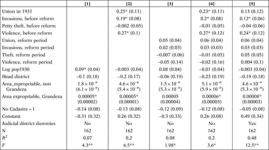
In Table 2, we display the main regressions on the determinants of the probability of having a settlement plan in Badajoz. Summary statistics and the table of correlations can be found in Appendix A.2 (online). Column [1] presents the coefficients obtained by simply regressing the settlement dummy variable on observed characteristics of municipalities: population, area included in the Registry of Expropriable Property (Grandeza-owned land and non-Grandeza-owned land), whether the municipality is the head municipality of the judicial district, the dummy for the existence of cadastral information. In column [2], we add the effects of previous collective action. In column [3] we look at the effects of contemporaneous collective action in isolation. In columns [4], we display coefficients of a model combining previous and contemporaneous collective action. In column [5], we add dummies for each judicial district to capture unobserved variables that could cluster at this administrative level.
DETERMINANTS OF SETTLEMENTS IN 1933 (EXTENSIVE MARGIN), BADAJOZ PROVINCE
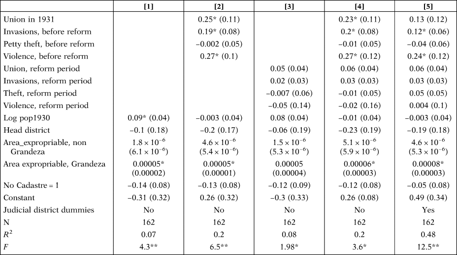
Notes: This table displays coefficients from linear probability regressions with the dependent variable taking value 1 if the municipality is reported to have a settlement approved and 0 otherwise. ‘Union 1931’ is a dummy variable taking value 1 if there was a peasant union registered in the municipality by October 1931. ‘Invasions, before reform’ is the number of invasions reported in the municipality from April 1931 to early November 1932. ‘Petty theft, before reform’ is the number of petty theft events reported in the municipality, from April 1931 to early November 1932. ‘Violence, before reform’ is the number of violent clashes reported in the municipality, from April 1931 to early November 1932. The next four variables are proxies for collective action that is contemporaneous to the deployment of intensification. ‘Union, reform period’ is the number of local peasant unions or comunidades reported in the Peasant Census 1933. ‘Invasions, reform period’ is the number of invasions between 3November 1932 and 31 May 1933. ‘Theft, reform period’ is the number of petty theft cases from 3 November 1932 to 31 May 1931. ‘Violent, reform period’ is the number of violent clashes in the same period. ‘Log pop1930’ is the natural logarithm of the municipality's population in 1930. ‘Head District’ is a dummy variable taking value 1 if the municipality is the head city in the judicial district and 0 otherwise. ‘Area expropriable, non Grandeza’ is the area in hectares included in the Registry of Expropriable Property that does not belong to Grandee aristocracy. ‘Area expropriable, Grandeza’ is the total area of farms owned by Grandeza, ‘No Cadastre = 1’ is a dummy variable taking value 1 if Carrión (1975 [1932]) does not report Cadastral data for the municipality, meaning most probably that the Cadastre had not been completed for the municipality.
Robust standard errors in parentheses. * denotes P < 0.05; ** denotes P < 0.01.
The regressions using the observations from the province of Badajoz show how, in this case, settlements approved by the IRA tracked previous collective action. The explanatory power of the models is reasonable. In column [1] with only the observable characteristics of municipalities, we get an R-squared of 0.07. With the full set of variables, collective action and spatial effects in column [5], we explain almost half of the variation. Dummy variables for the judicial districts alone concentrate almost half of the explanatory power of the model (once they are included the R-squared of the regressions goes from 0.2 to 0.48).
In columns [2], [4] and [5] there are positive effects of union presence in 1931. These positive coefficients are robust to the inclusion of contemporaneous collective action and the regional dummies. In some cases, in [2] and [4], the effect is positive, larg, and statistically significant. Presence of a union in 1931 is associated with an increase in the probability of settlements from 13 to 25 probability points.
We also get some robust coefficients for invasions and violence before reform. Invasion counts before reform obtain consistent, large and positive coefficients between 12 and 20 probability points for each extra invasion. Although our method does not allow us to reject the hypothesis of spurious correlation, this is no doubt a potentially large effect. In addition, violent clashes also increased the probability of having settlements approved by the IRA, with a robust, positive and large coefficient. A violent event potentially increases the probability of settlements by 25 probability points.
In columns [3] and [4] we see how settlement plans were not associated with contemporaneous collective action. In addition, petty theft cases before reform obtain a consistent negative coefficient (not statistically significant).
In our view, these coefficients can help us single out some mechanisms of collective action on conflict and discard others. There are three potential mechanisms. Firstly, a weak state capacity hypothesis in which policy can only be deployed effectively in areas with strong grass-roots organisations (state capacity mechanism). For example, local collective action pushes reform when the state is weak, that is peasants invade lands in anticipation of settlements. Secondly, poorly informed reformers rely on signals of distress to prioritise some municipalities over others (informational mechanism). Thirdly, reformers accelerate reform where local conflict is intense (public order mechanism).
The large coefficient on union presence suggests settlements were strongly correlated with previously existing local organisational capacities, therefore we cannot reject the weak state capacity hypothesis in which the state relies on local peasant unions to deploy reform.Footnote 7
The robust coefficient on invasions might suggest that the IRA simply certified existing illegal settlements, reinforcing the weak state capacity hypothesis. There are two caveats to this view. Firstly, the coefficient on contemporaneous invasions (‘Invasions, reform period’) is positive but very small (even in specifications in which we exclude previous invasions). Secondly, qualitative evidence suggests that illegal settlements were often repressed by the Guardia Civil. Unfortunately, we can only use the experience of some municipalities in the province of Cáceres. For example, on the 27 January 1933 landless peasants invaded several farms in Coria, Valdemoral and Arroyo del Puerco (now Arroyo de la Luz). The report stated that peasants stopped all work and voluntarily left the farms when the Guardia Civil appeared at the farm. Similarly, the Guardia Civil also interrupted a 50-strong invasion in Casas de Don Gómez (ABC 27 January 1933, p. 23).
Another possibility is that land invasions played an informational role, which is not incompatible with the weak state capacity mechanism. Invasions before the decrees of intensification might have reflected the existence of a large pool of unemployed workers, perhaps invading lands following the decree of laboreo forzoso in the autumn of 1931 (compulsory cultivation). In these cases, groups of unemployed peasants entering farms to perform unsolicited tasks were sometimes denounced as trespassers. These invasions perhaps sent stress signals to reformers, who were more willing to accelerate settlement plans in these municipalities.
We obtain a positive, large coefficient on the variable on violent clashes. This is consistent with the existence of important conflicts in Badajoz during this period which had strong impacts on public opinion: Castilblanco in December 1931, Montemolín and Salvaleón during the celebration of Labour Day in 1932. A robust, positive coefficient on the count of violent events before the passing of land reform could be compatible both with the informational mechanism (more violence, more local stress, therefore, more settlements) and the public order mechanism—settlements could be used to moderate radicalised peasants.
A second set of effects have to do with spillovers between land reform deployment (the Land Reform Law of 1932) and temporary settlements. We capture these effects with two continuous variables. The first is the amount of expropriable land that is not owned by Grandeza in the Registry of Expropriable Property. The second is the amount of Grandeza (expropriable) land in each municipality. The first variable, non-Grandeza expropriable land, commands generally positive, as expected, but not significant coefficients. However, the amount of Grandeza land obtains positive, large and robust coefficients. A one-standard deviation increase in the area of Grandeza-owned land increases the baseline probability by 13 probability points, equivalent to a marginal effect of 30 per cent. Although the area of Grandee-owned land in the municipalities is positively correlated with total expropriable area (the correlation coefficient is 0.37), the robust coefficient on total Grandee-owned land reflects the fact that the IRA was probably targeting Grandee-owned farms in this case. The weighted average of the total area temporarily expropriated for settlers in each municipality (weighted by total expropriable area) is 0.26, meaning only a quarter of all land affected by land reform was temporarily expropriated. This number reflects the fact that settlers occupied only one of the plots in the 4-year crop rotation traditionally used in Extremadura. The weighted average of the ratio of Grandeza-owned area to total expropriable area was 0.07 (weighted by total expropriable area in the municipality), meaning extra land not owned by Grandeza was needed to settle peasants. Yet the presence of quickly and cheaply expropriable land owned by Grandeza aristocrats initially drove settlements.
Other variables do not obtain large and significant coefficients. All contemporaneous measures of collective action fail to deliver significant coefficients (and the point estimates are small). The coefficient on the log of Population in 1930 changes sign in many specifications. The ‘Head of district’ dummy obtains large, negative coefficients, against expectations. Perhaps multicollinearity with other explanatory variables can explain the negative, counterintuitive coefficient. The head of district dummy has a positive correlation with Invasions and Violence, which command large positive coefficients. The main municipality in each district also typically had more presence than Grandeza and Grandeza presence also commands positive and large coefficients. Because we are looking at the extensive margin and the dependent variable has an upper bound of 1, perhaps the negative coefficient is understandable.
Some of the judicial district dummies turn out to have strong, statistically significant coefficients. As mentioned above, these dummies alone have quite a lot of explanatory power. It could well be the case that these regional dummies are closely correlated with observed and unobserved characteristics of the municipalities included in them. We control for a lot of observable variables in the regressions and it is unlikely that so many unobserved characteristics cluster by judicial district. For example, it could be the case that unobserved, more optimal conditions for the family farming cluster by judicial districts. If this were the case, we can expect more invasions in these locations with better conditions for family farming. However, collinearity with judicial districts dummies should reduce the size and statistical significance of the coefficients on the counts of invasions. However, when these dummies are introduced into the regression, the coefficients on violence and invasions before reform do not shrink. There is some reduction in the effect of ‘Peasant Union in 1931’. Perhaps it is not too adventurous to argue that the signs of the effects of judicial district dummies simply reflect the targeting of certain areas for the quick deployment of cultivation intensification.
In our view, the coefficients indicate a multi-causal model of settlement diffusion based on bottom-up and top-down forces. Union presence and pre-existing conflicts attracted reforms. We have argued that our regressions are consistent with the three potential mechanisms related to weak state capacity, informational signalling and public order concerns, with our evidence being consistent with all three (which in fact are not mutually exclusive). However, the explanatory power of local collective action is limited. When we expand our explanatory models to include interactions with broader land reform objectives, we see how settlements were mostly driven by the quick, low-cost expropriations of Grandeza property. In this context, the urgent relief policy of settling landless, poor and underemployed peasants was consistent with the broader political objectives of implementing land reform and weakening or punishing the Grandee aristocracy. In this context, land reform deployment followed broadly programmatic lines.
3.2. Settlements in Cáceres
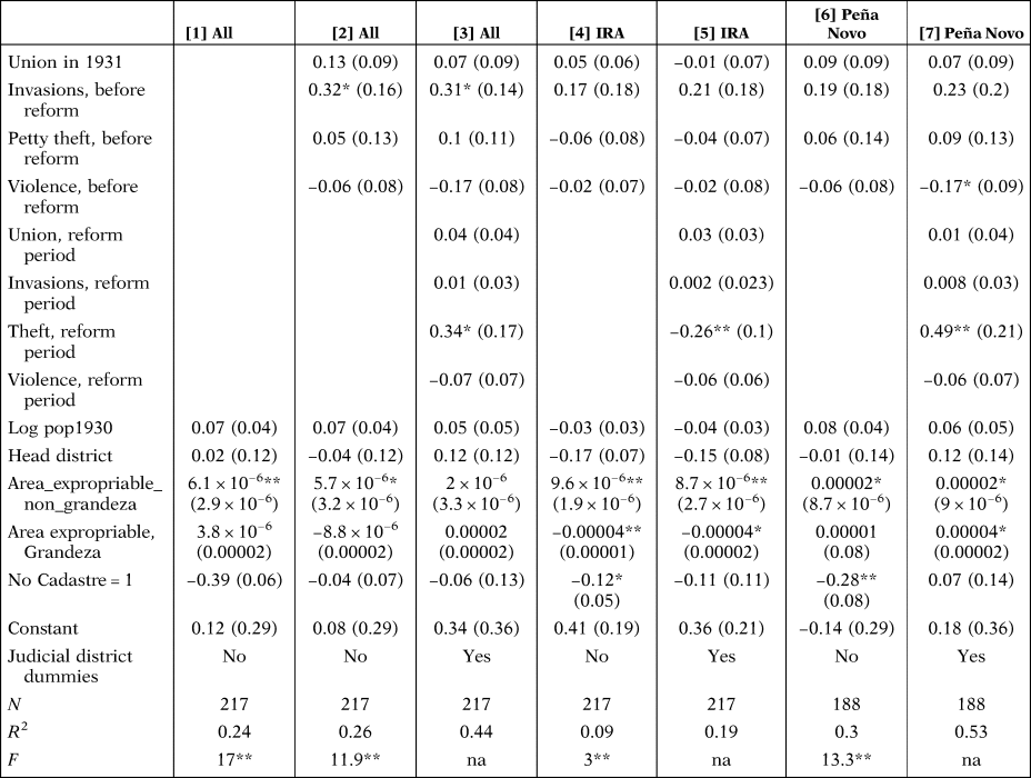
Next, we turn to Cáceres to understand the determinants of reform in the province. In Table 3, we present several variants of equations [2] and [3] applied to municipalities in Cáceres, also taking into account the different types of intervention. For reasons of space, we have moved some specifications to Appendix A.3 (online). In columns [1], [2] and [3] of Table 3, we display linear probability regressions in which the dependent is a dummy variable taking value 1 if the municipality reported any kind of settlement in 1933 and 0 otherwise. In columns [4], [5], the dependent variable is a dummy variable taking value 1 if the municipality was reported as having settlements managed by the IRA and 0 otherwise. In columns [6] and [7], the dependent variable is a dummy variable taking value 1 if the municipality was selected by prefect Peña Novo to have settlements and 0 otherwise. In these last regressions, we exclude from the municipalities in the province of Cáceres those already having a settlement managed by the IRA.
DETERMINANTS OF SETTLEMENTS IN 1933 (EXTENSIVE MARGIN), CÁCERES PROVINCE
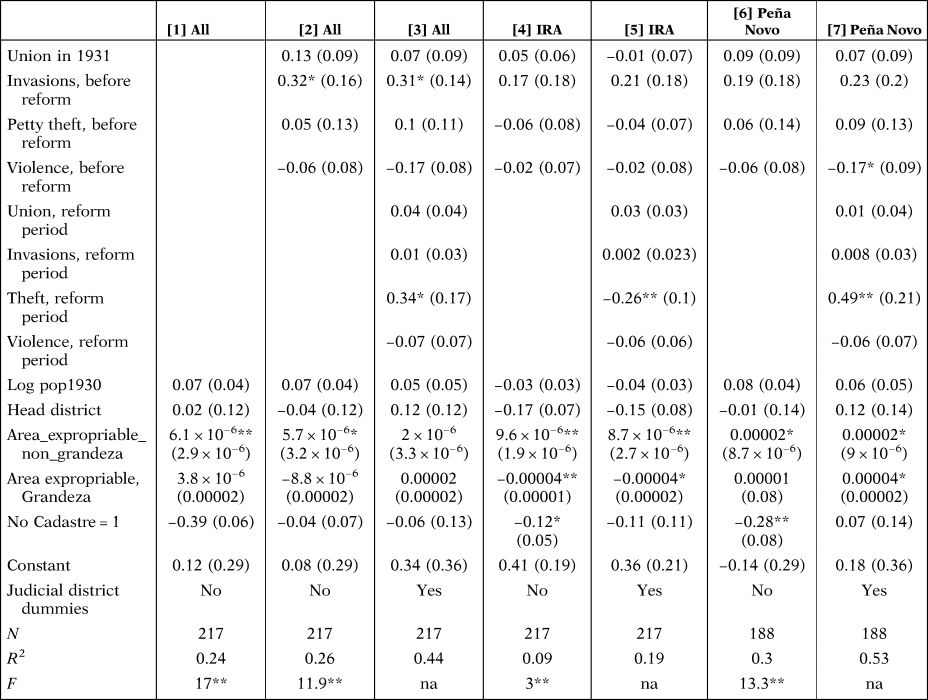
Notes: This table displays coefficients from linear probability regressions with the dependent variable taking value 1 if the municipality is reported to have a settlement approved and 0 otherwise. ‘Union 1931’ is a dummy variable taking value 1 if there was a peasant union registered in the municipality by October 1931. ‘Invasions, before reform’ is the number of invasions reported in the municipality from April 1931 to early November 1932. ‘Petty theft, before reform’ is the number of petty theft events reported in the municipality, from April 1931 to early November 1932. ‘Violence, before reform’ is the number of violent clashes reported in the municipality, from April 1931 to early November 1932. The next four variables are proxies for collective action that is contemporaneous to the deployment of intensification. ‘Union, reform period’ is the number of local peasant unions or comunidades reported in the Peasant Census 1933. ‘Invasions, reform period’ is the number of invasions between 3 November 1932 and 31 May 1933. ‘Theft, reform period’ is the number of petty theft cases from 3 November 1932 to 31 May 1931. ‘Violent, reform period’ is the number of violent clashes in the same period. ‘Log pop1930’ is the natural logarithm of the municipality's population in 1930. ‘Head District’ is a dummy variable taking value 1 if the municipality is the head city in the judicial district and 0 otherwise. ‘Area expropriable’ is the area in hectares included in the Registry of Expropriable Property, this does not measure directly expropriable land but is the total area of farms affected by land reform. ‘No Cadastre = 1’ is a dummy variable taking value 1 if Carrión (1975 [1932]) does not report Cadastral data for the municipality, meaning most probably that the Cadastre had not been completed for the municipality.
Robust standard errors in parentheses. *, denotes P < 0.05 ** denotes P < 0.01.
We start by considering the coefficients on the collective action variables. Compared with the case of Badajoz, we only see a large, positive impact of previous invasions on settlements. There is no contemporaneous effect of invasions, with contemporaneous invasions giving positive, but very small coefficients. As in the case of Badajoz, we speculate that the positive influence of previous land invasions on settlements is related to the decree of laboreo forzoso (compulsory cultivation). Under this system, peasants started unsolicited work on farms with the expectation of receiving a salary. It is probable that these events were labelled as ‘land invasions’. As in Badajoz, perhaps this channel can be characterised as invasions sending signals of demand for settlements, rather than meaning the IRA was simply certifying existing settlements (i.e. peasants implementing land reform, rather than the IRA). Certainly, contemporaneous invasions existed, but these are only weakly correlated with settlements in Cáceres in 1933.
In these regressions, union presence is less important than in Badajoz, with much smaller, positive coefficients, not statistically significant for both previous and contemporaneous peasant union presence. There were more municipalities with a registered peasant union in Cáceres, so union presence might have been a less crucial factor driving settlements. Also differing from the Badajoz case, violence commands negative, not statistically significant coefficients across all specifications. Previous petty theft obtains sometimes negative and sometimes fairly small positive coefficients and large and statistically significant coefficients in the case of contemporaneous petty theft cases. However, in this last case, IRA settlements are very negatively correlated with petty theft cases, and Peña Novo settlements positively correlated with contemporaneous petty theft. In the Peña Novo settlements, perhaps because they were perceived by landowners as less legitimate than IRA-run settlements, denunciations of petty theft occurred very often.
Across regressions, expropriable area is the most consistent determinant of settlements, both in the IRA and Peña Novo cases. Both Grandeza-owned expropriable land and non-Grandeza area receive positive coefficients, although only non-Grandeza land obtains statistically significant coefficients. Because the variable is skewed, we log the variable to see whether the results are driven by extreme values of area. However, there is no evidence that this is the case.
As in the case of Badajoz, the coefficients on expropriable area are large. A one-standard deviation in expropriable area (non-Grandeza) from the mean expropriable area with the rest of variables at their mean increases the probability of IRA settlements by 10 probability points, which is almost double the baseline probability. The effect is not statistically significant when we add the region dummies, but this is in part driven by large municipalities tending to cluster together, most probably because of geographic conditions (no natural barriers and the like). The capacity to settle as many landless peasants as possible in municipalities with very abundant land is a large explanatory factor in settlements.
Looking at the determinants of Peña Novo's settlement plans, there is now a stronger effect of Grandee presence, with a positive and statistically significant effect in some specifications. However, 22 per cent of municipalities chosen by Peña Novo to deploy settlement plans had Grandee-owned lands.
As in the case of Badajoz, the judicial district dummies absorb part of the spatial variation of the dependent variable. Because the Cadastre had not yet been completed in municipalities clustering in the North of the province, there is some multicollinearity between Cadastre absence and judicial district dummies. The dummy ‘Absence of Cadastre’ obtains negative coefficients, independent of whether the settlements were IRA-led or Peña Novo's.
The conclusions we derive from the close study of the spatial variation of settlements in 1932 and 1933 in both provinces is that expressions of local peasants’ distress such as invasions and violence were, in some localised cases, drivers of settlements. The same applies to our coefficients on proxies for local collective action. However, local, bottom-up pressures have limited explanatory power. An expanded explanatory model of spatial variation should include interactions of intensification of cultivation with the land reform of 1932, especially in relation to the objective of settling as many peasants as possible in municipalities with abundant land and with the expropriations without compensation of lands owned by Grandee noble families.
3.3. Intensive Margin of Land Reform. Timing and Loans to Settler Communities
In Appendix A.4. (online), we present the coefficients using the intensive margin of land reform. Firstly, the timing of approval of settlements is examined using a duration model to analyse whether settlements were deployed faster in municipalities with previous invasions. Perhaps an option for the future is to consider a variation of the event study analysis of settlements such as that found in González and Vial (Reference González and Vial2019). Preliminary coefficients of our parametric, duration model can be found in Table A4.1 and in Appendix A.4 (online). The explanatory power of the model is quite low, 0.17, in the case of Badajoz and 0.12 in the case of Cáceres. Collective action and conflict did not have an effect on the timing of temporary settlements. In addition, there is no evidence that loans disbursed to local unions (comunidades) closely followed local conflict and collective organisation. We do not find these results alter the results obtained from Tables 2 and 3 showing the preponderance of top-down, programmatic objectives driving land reform. We, therefore, display the coefficients of regressions with loans and timing of land reform as dependent variables in the Appendix (online).
In addition, we look at the variation in the loans disbursed per settler in Table A.4.2 in Appendix A.4 (online). According to our hypothesis, perhaps an interesting margin to analyse in municipalities with settlements is the speed at which funds were channelled to settlers. We have the amounts of the loans disbursed until 31 March 1933 in each municipality and calculate the ratio of loans disbursed per settler in municipalities having settlements. Total loans disbursed per household head had large variations. The average loan received per settler in Badajoz is 165 pesetas, but the standard deviation is 148 pesetas.
After analysing the variation in loans disbursed per settler, we hypothesise that settlers received more loans in municipalities with greater collective action and more conflict. For this reason, we regress loans disbursed per settler before the 31 March 1933 against the same variables in models [1], [2] and [3]. In Table A.4.2 (online), we can see that collective action did not affect this margin of the policy.
4. THE 1936 LAND OCCUPATIONS
The 1936 land invasions were larger and more comprehensive than those in 1932-1933. They were also considered more revolutionary. In March 1936, the main Socialist peasant union spoke about the «impatience and lack of self-control of the starved masses» forcing the Popular Front to accelerate land reform, especially speeding up the passing of the Yunteros decree of 3 March 1936 and the decree on the social use of farms (decreto de fincas de utilidad social) of 20 March (Gaceta de Madrid, 5 March 1936, pp. 1849-1850). Although anchored in what was the quite regressive land reform law of 1935, this decree represented a very substantive break with previous legislation. Article 2 of the law gave full powers to the IRA director to accelerate settlements using temporary occupations of land.Footnote 8
The result was a wave of occupations in most municipalities in the two provinces most affected by the yunteros decree and the decree on the social uses of land. At dawn on the 25 March, «between 30,000 and 60,000 peasants» occupied the lands in Extremadura according to various sources used by Sergio Riesco (Riesco Reference Riesco2006, p. 303), while Tuñón de Lara gives a figure of 30,000 or lower (Tuñón de Lara Reference Tuñón De Lara1985, p. 176).
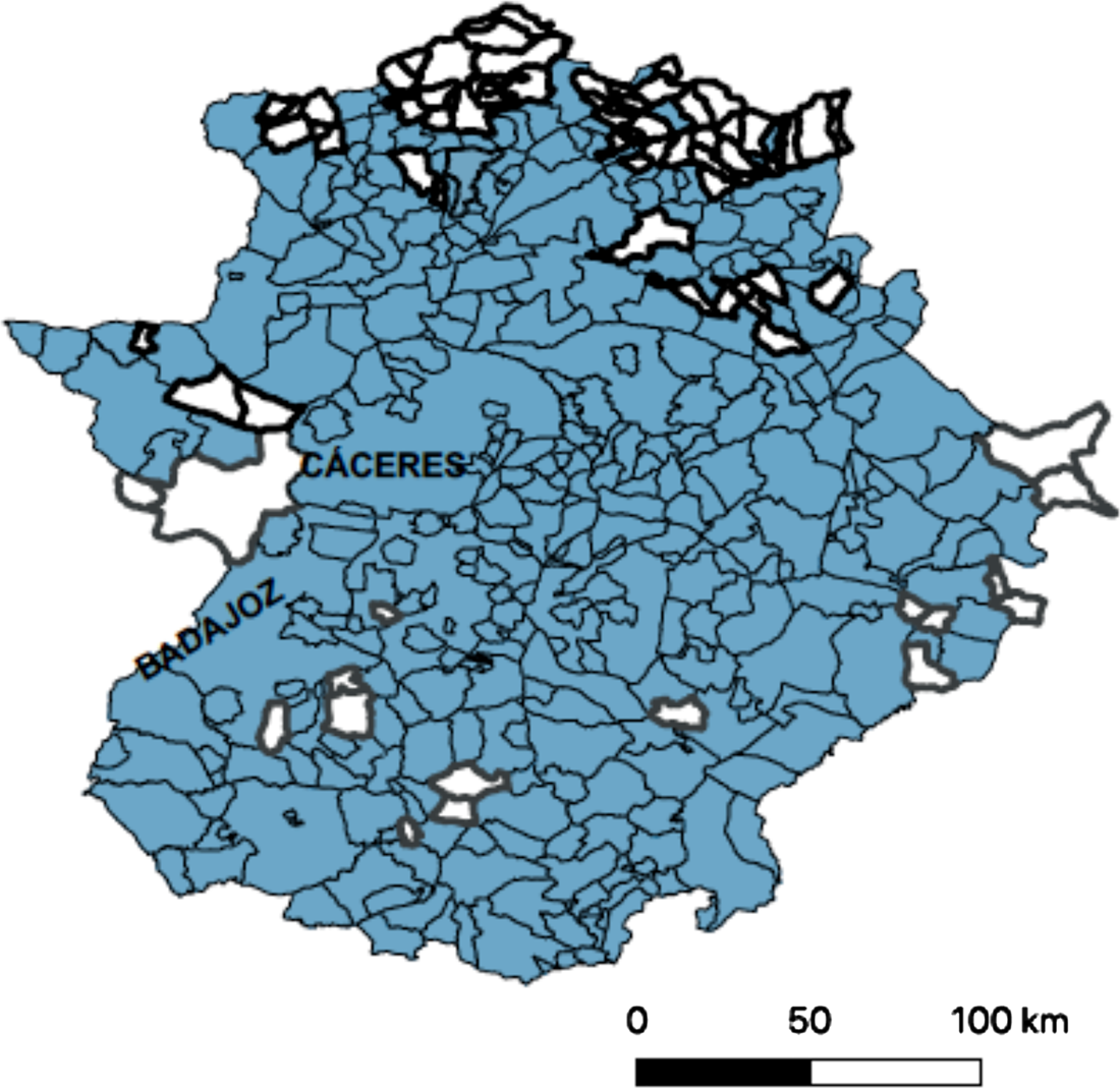
The bulk of settlements took place in March 1936, with some extra municipalities added in Cáceres in April, June and July 1936. In part, the urgency of invading lands on 25 March had to do with the need to start planting in earnest, as the period to plant summer cereals was about to end. According to the IRA, there were more than 80,000 settled household heads in Badajoz and Cáceres in 1936 (see Table 2). Given that there were about 30,000 settlers in the 1932-1933 wave, who had been evicted at the end of the summer of 1935, it means there were 50,000 settlers who could not have participated in previous invasions. In Figure 2, we show a map of the municipalities with settlements: brighter ones are those in which there were no settlements. Mostly they cluster in the north of the province of Cáceres. In Badajoz, the 17 municipalities with no settlements in 1936 did not report settlements in 1933 either, with only one exception (Alburquerque). Regarding this latter location, we could not find a clear explanation in the literature, although there was much legal discussion about the use of wastelands of Alburquerque (baldíos) and even a law passed on the 27 March 1935 (Lleó Reference Lleó1932; Gaceta de Madrid, 90, 31 March 1935, pp. 2532-2533).
LAND OCCUPATIONS AND SETTLEMENTS IN 1936. DARKER MUNICIPALITIES ARE MUNICIPALITIES WITHOUT SETTLEMENTS.
Note: Darker municipalities are municipalities with no settlements. Municipalities in Badajoz are in light grey and municipalities in Cáceres in white. We have also labelled the two capitals of each province
Sources: BIRA, 46, pp. 336-410; BIRA, 47, pp. 507-514; BIRA, 48, pp. 748-758; BIRA, 48, pp. 123-128.
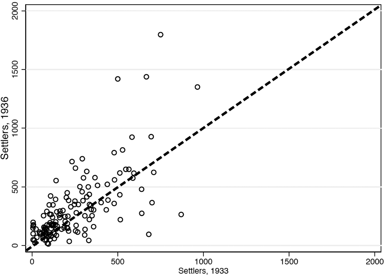
How different were 1936 land seizures from those of 1933? We can take the fraction of settled relative to the number of eligible household heads as a proxy for intensity. The intensity of land occupations was not higher in 1936 than in 1932-33. Among municipalities having settlements in 1936, the average fraction of settled household heads to eligible household heads was 0.57 (standard error, 0.02, N = 237) in 1936. This ratio was 0.62 in 1933 (standard error 0.05, N = 113).Footnote 9 However, in municipalities having settlements in both years, there was an increase in the number of settlers. For example, in Badajoz the number of settlers increased from 335 on average in 1933 (standard error 28.9) to 474 in 1936 (standard error 49.3). Even in this group, there was substantial heterogeneity. As is apparent from Figure 3, we can see there was a general increase in the number of settlers in 1936 relative to the number of settlers in 1933, but many municipalities also had fewer settlers. The most plausible explanation is that the variation around the fitted line reflects large movements of settlers among different municipalities, rather than changes within each municipality (mobilizing more or fewer peasants in the same municipality in 1933 compared with 1936). This prob`ably Typo explains the increase in the number of settlers in 1936 compared with those in 1933. In 1933, perhaps only the most suitable locations with abundant land had settlers. In 1936, the IRA attempted to settle most landless families. The increase of settlers simply reflects the movement of settlers from less ideal locations (not having settlements in 1933, because expropriable land was not abundant) to the most suitable locations.
SETTLERS IN 1933 AND 1936 IN EXTREMADURA.
Note: This figure shows a scatter plot of settlers in 1933 and settlers in 1936 in municipalities having settlements in both years. A 45 line is added in this graph. Each circle is a municipality-observation. The horizontal axis is the number of settlers in 1933 according to BIRA and Riesco (Reference Riesco2005). The vertical axis is the number of settlers in 1936 according to BIRA 46, 47, 48. N = 105
Sources: BIRA, 16, 46, 47. Riesco (Reference Riesco2005).

In addition, we can look at the fraction of land included in the Registry of Expropriable Property that was temporarily seized in 1933 and in 1936. Because outliers in very small municipalities distort the mean, we restrict the sample eliminating the observations with fractions of expropriated to expropriable land above 1. When we do so, the average rate of seized to expropriable land was 0.28 (standard error 0.019) in 1936 and 0.17 (standard error 0.018) in 1933. The average number of hectares seized by the municipality in 1933 was 602 (standard error 50.9) in 1933 and 656 ha in 1936 (standard error 72.3). In municipalities having lands seized in 1933 and 1936, hectares seized went up considerably from 656 in 1933 to 867 ha in 1936 (standard error 72.2).
The described patterns of settlements are too structured to square with a de-centralised, spontaneous wave of land invasions. We can further prove this point by looking at average plot size in 1933 and 1936 (the ratio between area expropriated and the number of settlers) in municipalities with settlements in 1933 and 1936. We divide the hectares seized in each municipality by the number of settlers as a proxy of average plot size given to settled families in each municipality and we calculate for municipalities having settlements in 1933 and in 1936 the ratio of plot size in 1936 divided by plot size in 1933 as a measure of average change in plot size between 1933 and 1936.
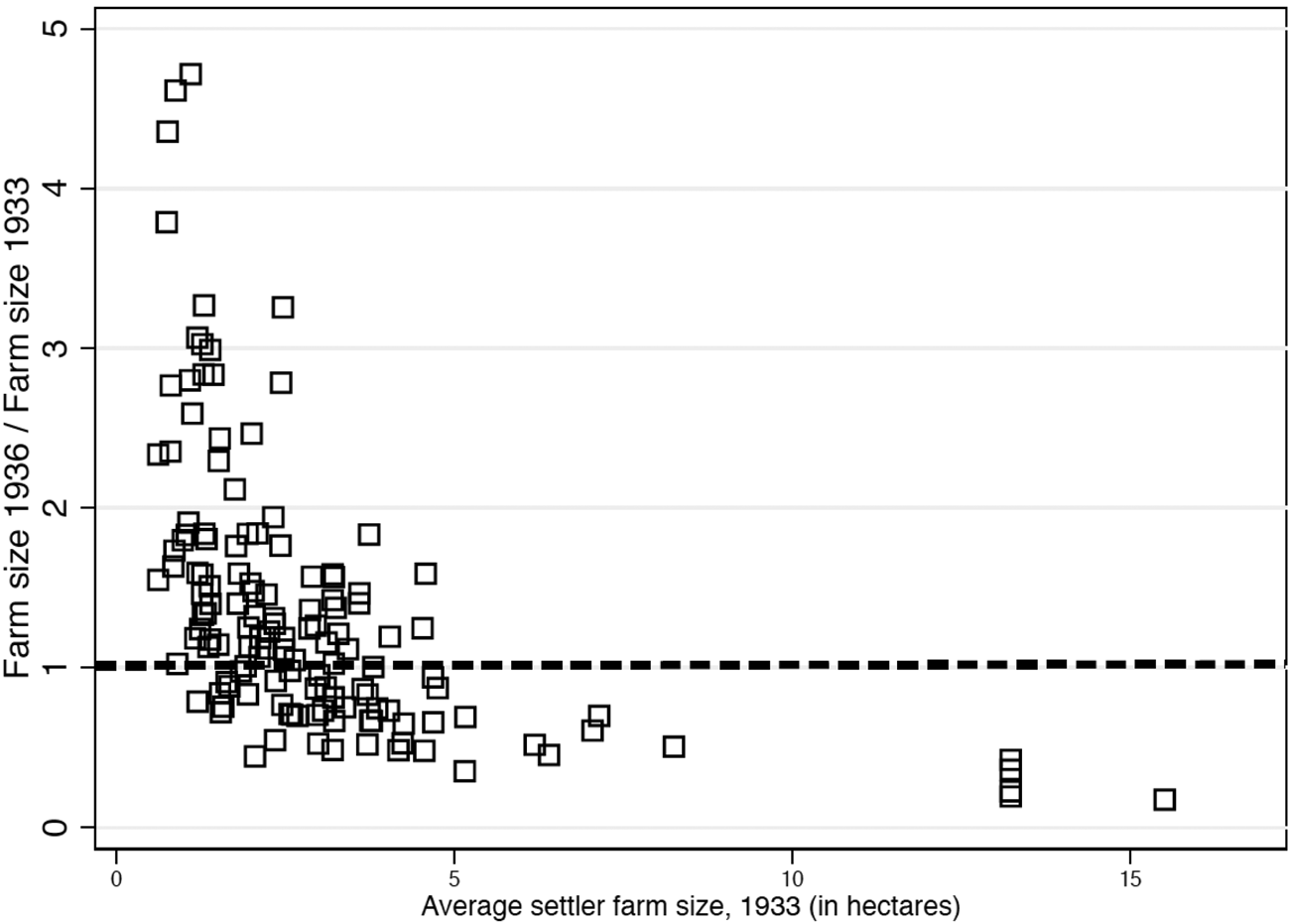
Typically plot sizes increased by around 30-40 per cent in 1936 compared with 1933 (average ratio is 1.4, when we exclude one outlier ratio above 20). We plot changes in farm size ratios in 1933 and 1936 against settler farm size in 1933. As is apparent in Figure 4, there is a very strong, negative correlation between increases in average settler farm size in 1936 relative to 1933 with average farm size in 1933. Municipalities with abundant expropriable land for settlers in 1933 (and therefore large farm sizes in 1933) get considerable reductions in allotted plot size in 1936 relative to 1933 (below 1, observations below the dashed line). In contrast, municipalities having small plot sizes in 1933 got the largest increases in plot size in 1936. This strongly suggests the existence of substantial re-shuffling of settlers between populations closely connected to the abundance of land. As in the case of proxies of land reform intensity, the variation in plot size is difficult to square with a de-centralised pattern of settlement. In addition, Figure 4 also indicates the existence of movements of settlers from one municipality to another rather than new participants crowding some municipalities. If the latter were the case, we could explain declines in average plot size in the most land abundant municipalities, but not the changes in municipalities with less land. In our view, the pattern of settlements in 1936 strongly suggests the existence of a relatively well-enforced, centralised rule of settlement that in our view can only be explained by strong top-down control of the pattern of settlements.
CHANGE IN AVERAGE SETTLER FARM SIZE BETWEEN 1936 AND 1933 AND AVERAGE SETTLER FARM SIZE IN THE MUNICIPALITY IN 1933.
Note: This figure displays a scatter plot of average plot size in each municipality in 1933 (horizontal axis) and the change in plot size in 1936 relative to 1933. N = 139 municipalities.
Sources: BIRA, 16, 46, 47. Riesco (Reference Riesco2005).

5. CONCLUSIONS
What lessons can we draw from the Extremadura experience to understand land reform implementation in developing economies? The Spanish case, especially in the regional case-study of Extremadura, has been considered a case of organised peasants driving land reform, which could mean Extremadura is a case in which popular collective action drove redistribution.
Contrary to this view, our study shows land reform in Extremadura quickly mutated from an uneven, short-term response to spontaneous bouts of rural conflict to a centralised, programmatic redistributive policy deployed by a medium-capacity state. The spatial deployment of land reform, therefore, combined the governmental reaction to signals of peasant distress with programmatic characteristics associated with classic land reform objectives. Spanish reformers seemed to have been particularly effective in deploying land reform quickly in two provinces, while Grandeza aristocracy proved to be powerless to resist land seizures and settlements. This suggests the existence of a relatively well-functioning state capable of deploying very controversial policies in specific parts of the territory.
Therefore, our case study indicates a middling level of institutional development and state capacity in 1930s Spain, away from the ‘weak state’ framework that characterises the study of policy implementation in developing economies (especially in the case of land reform; see Finkel and Gehlbach, Reference Finkel and Gehlbachforthcoming). Although without doubt spurred by pockets of rural conflict and organised peasant collective action, the Republican state could quickly deploy land reform, temporarily suspending property rights protection in specific areas of the country along programmatic lines, which meant 50,000 settlers who had not participated in previous invasions could be mobilised in 1936 (out of a total of slightly above 80,000 settlers). In this context, there were reinforcing feedback loops between state intervention and peasant collective action, which amplified the mobilisation of the poor far beyond purely structural factors (Domenech Reference Domenech2013).
Finally, at the risk of overstretching the conclusions of what is a quite exploratory paper, we think several of our results can help place Spain's land reform differently in the comparative history of land reforms. In an excellent comparative analysis of 20th-century land reforms, Michael Albertus considered Spain as the only case in which land redistribution followed Acemoglu and Robinson's (Reference Acemoglu and Robinson2006) model predictions of political transitions (Albertus Reference Albertus2015, p. 276). In this model, elites accept democracy and limited redistribution only under a serious threat of revolution (Acemoglu and Robinson Reference Acemoglu and Robinson2006).
We argue, however, that Spain is much closer to a case of land reform deployment with elite splits and weak protection of property rights. Although Spanish peasants had a long history of collective action, it can be argued that high levels of peasant organisation were by no means universal in the area studied, meaning land redistribution did not follow the strength of local peasant collective action. Instead, results presented here are consistent with a relatively powerful executive power, facing temporarily politically isolated landed elites, especially in the case of the aristocratic landowners. The 1931 election completely disbanded the highly disorganised monarchist and conservative parties (Ziblatt Reference Ziblatt2017, pp. 344-353). In 1936, the re-organisation of Leftist parties in the Popular Front also delivered a solid majority in favour of land redistribution. In the absence of institutional vetoes and counter-balancing powers, large, cohesive majorities could push decidedly in favour of redistribution or reverse redistribution if the governing coalition opposed it. The result was massive policy shifts after major electoral changes. With Leftist, pro-redistributive majorities in 1931 and 1936, landowners could only protect their assets by supporting military coups aimed at forcefully changing the composition of ruling elites. Leftist parties organised a coup in October 1934 to oust a Rightist coalition. Our study of land reform deployment is consistent with recent revisionist views on the causes of democratic breakdown in 1930s Spain which stress the role of intra-elite competition, drastic ruling elite turnover and large policy shifts (Colomer Reference Colomer and Colomer2004; Lapuente and Rothstein Reference Lapuente and Rothstein2014; La Parra-Pérez Reference La Parra-Pérez2019a, Reference La Parra-Pérez2019b).
Supplementary material
The supplementary material for this article can be found at https://doi.org/10.1017/S0212610920000087.
ACKNOWLEDGEMENTS
We thank the valuable comments and suggestions from editors and anonymous referees, especially the Chief Editor and three anonymous referees at this journal. All errors and omissions are ours only.
Pablo Martinelli thanks the financial support from Spain's Ministry of Science, Innovation and Universities under project HAR2016-76814-C2-1-P.