

Introduction: Paths That Cross Time
On May 10, 1797, the Governor of the Captaincy of Pará, in Portuguese America, wrote to a Secretary of State in Portugal. He informed him that the residents of Pará’s capital were compelled to wait more than a year to receive a response to the correspondence they had dispatched to Pernambuco’s capital, Recife. That was if there were no accidents along the way, which were very common in this governor’s experience.Footnote 1 However, a significant transformation would occur just a decade later, when a vassal of the Portuguese Crown residing in the city of Rio de Janeiro encountered a markedly different situation: the advent of maritime and inland mail services, operating with remarkable regularity, marked by an unprecedented frequency of departures, with over seventy destinations being reached almost daily. At the turn of the century, political life was changing, and the times and spaces of communication were transforming.
The present article examines a variety of legal and administrative documents, letters, almanacs, and newspapers, with a focus on the establishment and evolution of a space-time structure created by the postal network in Portuguese America. The argument is that postal services underwent an expansion in terms of geography, diversification of territories connected to the network, intensification of the frequency of their flows, and acceleration of the pace of postal circulation. This process integrated a broader space-time compression; that is, an acceleration in time communications through the shrinking of distances. This space-time compression is linked to a revolutionary context in which political communication has become increasingly urgent. In the case of the Portuguese empire, the throne’s migration to America gave rise to a set of reforms that led to the acceleration of postal communications.
Although it is not a new area of study, the connections between empires and communication systems in the modern era have recently attracted the attention of important researchers.Footnote 2 An example of this is the dossier assembled by Léonard Laborie and Heidi Tworek, in which the authors relate postal networks, from the sixteenth to the twentieth centuries, with processes of globalization.Footnote 3 These efforts are complemented by historians specializing in the Spanish American Mail, including Nelson Fernando González Martínez, José Araneda Riquelme, Sylvia Sellers-García, and Milagros Belén Blanco; those focusing on the Portuguese and Luso-American Mail, such as Margarida Sobral Neto and Mayra Guapindaia; and scholars devoted to the Brazilian Mail, such as Pérola Castro. Collectively, these researchers have renewed the study of the political, social, economic, and cultural history of modern Ibero-American postal communications.Footnote 4
This article seeks to provide a contribution to these efforts by offering a new perspective on the history of the Luso-American postal service. It attempts to evaluate the structure of the postal network in its spatiotemporal dimensions. Taking into account issues raised by Reinhart Koselleck, Milton Santos, Yrjö Kaukiainen, and Hartmut Rosa, I consider that the modern experience of time is characterized by the progressive dissociation between “spaces of experience” and “horizons of expectation”; that the perception of the simultaneity of distant events depends on information transmission techniques; that the development of regular postal systems accelerated the transmission of information; and that the experience of modernization is an experience of acceleration.Footnote 5
This historical framework encourages an investigation into the influence of postal communications on social experiences of space and time. Furthermore, it highlights a new way of grounding the understanding of the modern time experience, linking it to a modern spatial experience. If the former is described as increasingly faster, the latter indicates a developing tendency towards interconnectedness; that is, the growth of networks and communication density, leading to topological spaces.
The first half of this article focus on the initial phase of the Luso-American postal network after its consolidation in 1800. The first network’s morphology was reconstructed through analysis of political communication among the institutions and agents responsible for its creation: the prince regent of Portugal, one of his ministers, the governors of the captaincies, and the local treasury units (Juntas de Fazenda). While I have already discussed part of this dialogue in a separate article, I will emphasize the network’s geographical aspects at its first stage. The aim is to provide sufficient elements for a diachronic approach.Footnote 6
The second half is dedicated to the analysis of the reforms that took place from 1808 onwards, after the center of the Portuguese empire was settled in Rio de Janeiro to escape Napoleonic forces. Along with the drastic changes that followed this event, the postal network was further expanded; the opening of Luso-American ports to other states led to an increase in maritime communications; new methods of connecting territories were required to establish government institutions; and the ongoing war was a factor that deepened the urgency for faster communications. In summary, the government’s need to respond to a rapidly changing world, facing the effects of the Napoleonic wars in the Ibero-American and Atlantic spaces, caused a structural crisis in the forms of legitimization and exercise of political power, threatening territorial sovereignty. This crisis provided the foundation for the compression of space-time.Footnote 7
To demonstrate this topological shift in communication, I will compare three variables. First, the geographical distribution of post offices and mail lines. The argument is that after 1808, both increased in number, covering wider areas. Second, alongside the restructuring of Rio de Janeiro as the new center of the empire, the emphasis on internal communication increased, leading to changes in network connectivity. Third, the space-time compression was achieved by shortening distances and accelerating the frequency of postal flows. All three variables were mapped with different methods of digital cartography. Furthermore, an important observation needs to be made at this stage: the acceleration was not due to technological innovations; that is, there was no technical improvement in postal services at the time. Therefore, the explanation for the phenomenon of acceleration lies elsewhere: in the social organization of human circulation.
Following Pimenta’s definition, I consider that any notion, conception, representation, concept, or concrete action that a society carries out in space and is based on time constitutes a space-time.Footnote 8 It is a particular set of spatial practices and representations of space that shape social experiences of a relative space.Footnote 9 The 60 days that sailors calculated to cross the Atlantic from Pará to Lisbon, or the three months from Lisbon to Rio de Janeiro, are examples of temporal distances. The fact that every 15 days one messenger would be sent from the Minas Gerais captaincy to Rio de Janeiro, or that every month another one would be sent from Rio to São Paulo’s captaincy, is an example of regularity. Temporal distance and regularity constitute two different types of social space-time. Under the prerogative of enhancing territorial integration of the Portuguese empire, as evidenced, for example, in the writings of D. Rodrigo de Sousa Coutinho, the Luso-American postal system was built upon the temporalization of a network space.Footnote 10 For this reason, I consider that it created a new topology of time.
1. Origins of the Postal Network in Portuguese America
The final years of the eighteenth century were not peaceful for the rulers of the Portuguese empire. Mining in the American colonies had been declining since the mid-century, and reform policies had been drawn up to regenerate the kingdom’s economy. During the eighteenth century, the Portuguese occupation of America moved farther inland, its agricultural production diversified, administrative frontiers were redrawn, and the free and enslaved populations grew. The Luso-American colonies became increasingly important for the empire’s economy.
In the meantime, competition among European empires escalated to encompass the struggle for dominance over the American colonies. On the one hand, the Portuguese monarchy was striving to renew the sources of economic exploitation in America; on the other hand, the territorial integrity of its colonies was under threat. This was the context in which the Secretary of State for the Navy and Overseas, D. Rodrigo de Sousa Coutinho, was charged with establishing a postal system in Portuguese America in 1796.Footnote 11
Until then, at sea, epistolary flows throughout the empire took place on commercial or official vessels, with irregular periodicity, rhythm, and itinerary. On land, occasional travelers, merchants, drovers, cattlemen, servants, private messengers, and enslaved people, among other social categories, carried a large part of the correspondence.Footnote 12 At the end of the eighteenth century, however, Coutinho recognized the danger of entrusting these establishments, such as the Post Office, to private individuals. For him, the fact that Benjamin Franklin, former postmaster of the British colonies in America, had been deeply involved in the United States’ independence was clear evidence of the power of communications.Footnote 13
With the assistance of colonial authorities, Coutinho outlined the first postal network of Portuguese America. It was based on a new spatial paradigm that changed the geography of political and economic communications. The geography of this communication network contributed to the integration of different scales of the empire: the “regional” became more articulated with “Luso-American” and “imperial” scales.Footnote 14 Established in 1798 and consolidated in 1800, this network had a specific feature that sought to meet the expectations of many contemporaries: it had to make communications faster, more regular, and more frequent. For this reason, the foundations of this postal service were designed through notions of time and conceptions of space; that is, space-time.Footnote 15
A Portuguese dictionary published at the beginning of the nineteenth century defined the word “caminho” (path) not only as “lugar por onde se anda” (the place where one walks), but also as the “distância de um sítio a outro determinada pelo tempo” (distance from one place to another determined by time). A feature commonly attributed to the postal system by colonial authorities highlighted its ability to “estreitar” (strengthen) ties among the inhabitants of a state. This verb, however, was defined not only by the reduction of space, but also by the possibility of “estreitar-se a distância do tempo” (narrowing the time distance).Footnote 16
The semantics of these words—together with others such as “prontidão” (readiness), “regularidade” (regularity), “aproximar” (to approach), and “brevidade” (brevity)—reveal how specific dimensions of the Portuguese social experience of space were fundamentally entangled with time. Words that were widely used to talk about the Post Office and to highlight its singularity in relation to previous forms of communication were often conceptualized through words such as “incerteza” (uncertainty), “insegurança” (insecurity), and “interrupção” (interruption).Footnote 17 I consider, therefore, that there are specific notions of space, such as “proximity” and “distance,” that can be better experienced over time, and that a new semantics of communication conditioned the forging of the postal network in Portuguese America.Footnote 18
From a conceptual perspective, it is through the linguistic apprehension of this temporal experience of space that the concrete organization of the postal network acquired its space-time feature.Footnote 19 On the one hand, its construction presumed the handling of notions and conceptions of this nature, hence the use of words with space-time meanings. On the other hand, once territorialized, the network amplified the daily actions of this type and changed the social practices of communication, rendering them more temporalized. In other words, the maintenance of a socially constructed space always requires collective thought and action; in this sense, the postal network could become a topology of time.Footnote 20
With a few exceptions, the period from 1800 to 1807 witnessed relative stability within the Luso-American postal system. As expected of an emerging institution, unforeseen events and circumstantial factors made it impossible for the Portuguese to achieve the ideal they had envisioned. Whether on land or at sea, letter carriers were not always able to accommodate the time distance stipulated by postal administrations, nor did they always have the means to prevent postal packages from being broken into. Sometimes it was challenging to meet the required regularity. In a sense, it was still a world that offered many reasons to expect delays. However, the construction of this postal network was carried out precisely to meet a new social, commercial, and political demand to reduce the uncertainty and slowness of communication, as a tool to face revolutionary times. Nevertheless, the effects of this policy were felt by large swaths of society, as the state sought to ensure that all correspondence, whether official, commercial, or personal, was sent through the post office.Footnote 21
2. Luso-American Postal Network (1800–1807)
Placed throughout the Luso-American captaincies and in Portuguese Angola, the postal system established the gravitational poles and regular flows that stitched together large parts of the empire. But, like any social construction of space, it was marked by asymmetries (Figure 1).Footnote 22
Post Office in Portuguese America in 1800.
Source: Thomáz Fortunato, “Temporalización del espacio,” 34.

Figure 1 Long description
The map illustrates the postal system in Portuguese America in 1800, displaying post office infrastructure and postal connections. Black dots represent post office locations, while lines indicate postal routes. The map covers parts of South America and Africa, showing connections between these regions. The postal connections are divided into northern and southern routes, with different line styles representing each. The map highlights the gravitational poles and regular flows that stitched together large parts of the empire, marked by asymmetries.
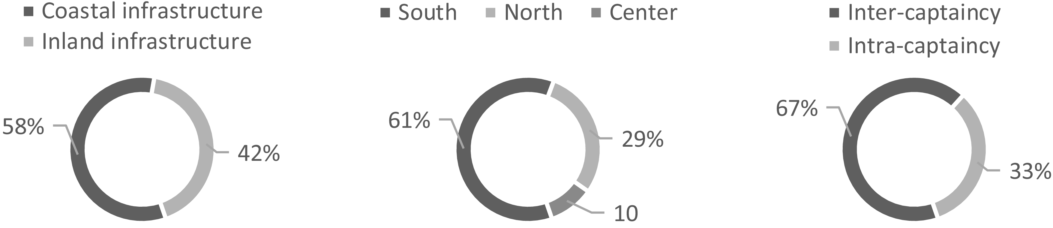
The coastal infrastructure formed a backbone linking maritime communications with the continent’s interior. The capitals of Rio de Janeiro and Pará were its main vertebrae: they formed a “betweenness centrality”; that is, not only did the “degree” of connections make them essential nodes in the network, but also they were key locations for connecting larger parts of the postal space.Footnote 23 There were around 31 post offices and 39 postal lines; more than half of the offices (18, or 58%) were on the coast, and a smaller part (13, or 42%) were inland. The southern region had the most significant number of post offices (19, or 61%), followed by the north (9, or 29%) and the center (3, or 10%). On the continent, the most essential connections were those between different captaincies, as only a third of the postal lines (13 or 33%) linked different regions of the same captaincy (Graph 1). The territorial integration was more intensive at the Luso-American and imperial levels.
Postal System Morphology of Portuguese America in 1800.
Source: see appendix.

In the Atlantic Ocean, as part of the whole Portuguese postal system, the vast majority of correspondence was transported by commercial vessels.Footnote 24 Between 1798 and 1807, their main destinations were the ports of Bahia, Pernambuco, Rio de Janeiro, Maranhão, Pará, Paraíba, Rio Grande de São Pedro, and São Paulo.Footnote 25 By cross-referencing Guapindaia’s data on packet boats with newspapers’ maritime notices, it can be seen that, in the Atlantic, the trade’s geography was fundamental to the postal network. Although the postal network contributed to reinforcing territorial integration at Luso-American and imperial levels, its connectivity was highly asymmetrical, and Lisbon was clearly the central node where the system converged (Figure 2).Footnote 26
Postal Connectivity of Portuguese America in 1800—Macro-Regions.
Source: Thomáz Fortunato, Topologias do tempo, 190.

Figure 2 Long description
A horizontal dot plot representing the postal connectivity of Portuguese America in 1800. The plot features various regions and locations connected to Lisbon, which is the largest node. Each circle’s diameter indicates the number of connections (degree centrality) for that location. Notable locations include Rio de Janeiro, São Paulo, Bahia, and several islands such as Ilha da Madeira and Ilha Graciosa. Connections between these locations are depicted with lines. The plot highlights the central role of Lisbon in the postal network, with numerous connections radiating from it to other regions.
As long as written communication was based upon human travel, an aspect of this postal culture was the consciousness of a time lag.Footnote 27 In practical terms, this meant that when a Governor of Bahia received a letter from Lisbon, he knew that it had been sent about a month previously. When a Secretary of State in Portugal received news from Bahia, he knew that the information had been forwarded at least three months earlier. This long-distance dialogue, therefore, would only be completed, in the best-case scenario, after more than four months. The Governor of Mato Grosso, in contrast, had very different space-time conditions: he had to wait approximately ten months to complete this dialogue with Lisbon.Footnote 28
The city of Lisbon was between 34 and 42 days’ sail from Salvador, not much different from the ports of Vitória, in Espírito Santo, and Rio de Janeiro. From Lisbon, if the correspondence had been sent to Vila Rica, Minas Gerais, the metropolitan letters would have taken about 45 days to reach their destination. If their addressees were based in Vila Boa, Goiás, another 49 days would have been added to the journey. To reach Vila Bela, Mato Grosso, the letters from Lisbon would have had to cross at least 155 days in the whole journey.
If, instead of entering the interior, letters from Portugal went from Rio de Janeiro to the city of São Paulo, they would be in the hands of their recipients in 38 days; in 47 days, they could reach Desterro, Santa Catarina; and in 57 days, they could reach the capital of Rio Grande de São Pedro. To reach the north—the capitals of Pernambuco, Paraíba, and Rio Grande do Norte—letters from Lisbon would take between 30 and 41 days, sometimes 50. To reach the ports of Ceará, Piauí and Maranhão, sailors would travel around 45 or 55 days; to Belém, Pará, between 55 and 65 days, from which point they could enter the Amazon River and continue to the town of Barcelos, Rio Negro’s capital, making the letters from Portugal travel for a total of 95 days (Figure 3).
Lisbon at the Postal Time Topology—1807.
Source: Thomáz Fortunato, Topologias do tempo, 204–205.

Figure 3 Long description
A scatter plot displays geodesic locations marked with filled circles, spacetime locations with open circles, and points of reference with gray circles. Displacement vectors are represented by lines connecting these points. The map includes parts of South America, Africa, and Europe, with a grid overlay. The plot illustrates the spatial and temporal relationships between these locations, showing how geodesic and spacetime positions differ. The vectors indicate the direction and magnitude of displacement. The dataset appears to cover a wide geographical area, with clusters of points and vectors concentrated in certain regions. All values are approximated.
The position occupied by Lisbon in the postal time topology is built on these space-time data. By replacing the Euclidean distances with time distances, one can represent time topology in cartographical space.Footnote 29 All the political-administrative centers on the coast leaned towards Lisbon, which in turn moved away from the captaincies of Goiás, Mato Grosso, and Rio Negro. In general terms, a contraction of the Atlantic Ocean and a dilation of Portuguese America occurred. Although this was the case for Lisbon, when considering the time topology of every capital in Portuguese America, we can identify four distinct space-time zones that represent the main trends in space-time communication (Table 1).
Approximate Temporal Distances of Postal Communications in Portuguese Empire (1807)

Table 1 Long description
A table with five columns and sixteen rows, including headers. The columns are labeled ‘DESTINATION’, ‘Rio de Janeiro’, ‘Recife’, ‘Belém’, and ‘Vila Bela’. The ‘DESTINATION’ column lists various locations such as Lisbon, Salvador, Rio de Janeiro, and others. The other columns show the average days it took for postal communications to travel from these origins to the destinations. For example, from Rio de Janeiro, it took 95 days to reach Lisbon, 3 days to reach Salvador, 0 days to reach Rio de Janeiro itself, and so on. Each row provides the average days for each origin-destination pair.
Source: see appendix.
From the perspective of individuals based in these capitals, the space-time structure entails a different set of distances. Hence, the shape of the time topology underlying the communication space shifts in each case. If we take Rio de Janeiro as the place of origin of a mail dispatch, then Angola and Lisbon are very close, as well as the coastal cities between Rio Grande de São Pedro and Rio Grande do Norte, the point from which the obstacles of navigation force the sailors to make a long detour around the Atlantic Ocean, distancing Rio de Janeiro from the Ceará, Piauí, Maranhão and Belém captaincies.Footnote 30 Crossing the interior lands also required a substantial amount of time. To give an idea of the social significance of this distance, at that time, sailing from Macau, China, to Rio de Janeiro took about 148 days. This means that China, on the other side of the world, could be closer to Rio than Barcelos, Rio Negro’s capital in Portuguese America (Figure 4).
Rio de Janeiro at the Postal Time Topology—1807.
Source: Thomáz Fortunato, Topologias do tempo, 211.

Figure 4 Long description
A scatter plot displays geodesic locations marked with black circles, spacetime locations with open circles, and a point of reference with a gray circle. Displacement vectors are represented by arrows connecting these points. The plot is overlaid on a map of parts of South America and Africa, with lines indicating geodesic paths. The data points show varying distances and connections, reflecting the spatial and temporal relationships from the perspective of Rio de Janeiro in 1807. Clusters and patterns indicate closer proximity to certain regions like Angola and Lisbon, while other areas, such as coastal cities and interior lands, show greater distances and navigational challenges. All values are approximated.
If the point of reference is Recife, Pernambuco, then the space-time curvature takes another shape. As in Rio’s case, Lisbon, Angola, and the southern ports are closer than the continent’s interior. Nevertheless, the time distance to western coastal cities is not very long (Figure 5).
Pernambuco at the Postal Time Topology—1807.
Source: Thomáz Fortunato, Topologias do tempo, 222.

Figure 5 Long description
A scatter plot illustrating the relationship between geodesic and spacetimes locations with displacement vectors across a map of South America and parts of Africa and Europe. The plot features numerous data points marked by black circles representing geodesic locations, white circles for spacetimes locations, and grey circles for points of reference. Displacement vectors are depicted as arrows connecting these points. The x-axis and y-axis represent geographical coordinates, with values estimated based on the map’s grid. Clusters of data points are visible along the eastern coast of South America, particularly around Recife, Pernambuco, and extending towards Africa and Europe. The plot shows a notable curvature in the displacement vectors, indicating varying time distances between locations. Western coastal cities in South America appear closer in time distance to Recife than the continent’s interior. The overall trend suggests a complex spatial-temporal relationship, with some outliers and gaps in the data distribution. All values are approximated.
A third shape of the space-time fabric arises when we take Belém as a point of reference. In this case, Pará’s capital is far from almost all of the other cities in Portuguese America, except São Luís and Vila Boa, followed by Lisbon across the Atlantic Ocean (Figure 6).
Pará at the Postal Time Topology—1807.
Source: Thomáz Fortunato, Topologias do tempo, 227.

Figure 6 Long description
A scatter plot showing geodesic and spacetime locations of cities in Portuguese America. The plot features numerous data points connected by lines, representing displacement vectors. Geodesic locations are marked with black circles, spacetime locations with open circles, and a point of reference with a gray circle. The plot includes a grid overlay and lines connecting various points, indicating relationships between cities. The data points are spread across the map, with some clustering near certain regions. The x-axis and y-axis represent geographical coordinates, with values indicating actual locations. The plot highlights the spatial and temporal relationships between cities, showing how they are connected across the space-time fabric. All values are approximated.
The fourth shape that the space-time net acquires arises when we adopt the perspective of someone based in Vila Bela, Mato Grosso. In this case, Rio Negro and Goiás are the two closest captaincies, and Lisbon is practically half a year away (Figure 7).Footnote 31
Mato Grosso at the Postal Time Topology—1807.
Source: Thomáz Fortunato, Topologias do tempo, 216.

Figure 7 Long description
A scatter plot illustrates the geodesic and spacetime locations with displacement vectors in South America. The plot features a grid overlay with multiple lines representing different paths and vectors. Black circles mark geodesic locations, while open circles indicate spacetime locations. A gray circle represents the point of reference. The displacement vectors are shown as arrows pointing in various directions. The plot captures the spatial and temporal relationships between different locations, highlighting the distances and directions of movement. The dataset appears to focus on the year 1807, with a specific emphasis on Mato Grosso. The overall trend shows a complex network of connections and movements across the region. All values are approximated.
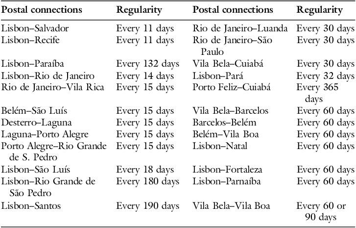
But what would this space-time represent for society and political institutions if the postal system were not able to maintain them? For this time topology to become a structure of social and political life, it needs to be relatively regular. It is through the stabilization of this speed that space-time crystallizes into a time topology, capable of shifting the rhythm of daily life. This is the meaning highlighted by Osterhammel when he claimed that “temporal regularity is necessary to experience acceleration.”Footnote 32 This was also true for the Luso-Americans living at the turn of the eighteenth to the nineteenth century. As one of them noted, “Regularidade é e foi sempre a maior vantagem do Correio” (Regularity is and always has been the Post Office’s greatest advantage) (Table 2).Footnote 33
Post Office Approximate Regularity (Portuguese Empire, 1800–1807)

Table 2 Long description
A table with two columns each titled Postal connections and Regularity. The table lists various postal connections and their regularity in days. The first column includes connections such as Lisbon-Salvador, Lisbon-Recife, Lisbon-Paraíba, Lisbon-Rio de Janeiro, and Rio de Janeiro-Vila Rica, with regularities ranging from every 11 days to every 190 days. The second column includes connections such as Rio de Janeiro-Luanda, Rio de Janeiro-São Paulo, Vila Bela-Cuiabá, Lisbon-Pará, and Porto Feliz-Cuiabá, with regularities ranging from every 30 days to every 365 days.
Source: see appendix.
Bahia, Pernambuco, and Rio de Janeiro were the most frequent points of connection between Lisbon and the American colonies. In a sense, commercial geography projected itself onto postal maritime geography. That is, postal communication served not only political imperatives but also commercial interests.Footnote 34 The inhabitants of Rio de Janeiro were more frequently connected to Vila Rica, Angola, and São Paulo. In the north, São Luís’s primary postal connection was with Pará; those of Natal, Fortaleza, and Parnaíba were with Lisbon. In the south, the mail went more frequently from Desterro to Laguna, and from there to Porto Alegre, from where it went more regularly to Rio Grande de São Pedro’s capital. In the center, Vila Bela is connected to Cuiabá every month, to Barcelos every two months, and to Goiás every 60 or 90 days. Between Barcelos and Belém, a messenger would leave every two months, the same frequency as the postal connection between the capitals of Pará and Goiás. While commercial shipping was fundamental to postal exchanges in the Atlantic Ocean, in Portuguese America, despite the use of preexisting routes, the postal service brought about a greater transformation in the system of information transmission.
3. Postal Reforms
The establishment of the Luso-American postal system took place during the turbulent period at the beginning of the nineteenth century. In 1807, competition among European empires intensified and reached a critical point. The war between France and Great Britain had resumed in 1803. While Napoleon was expanding his domain across Europe, the British were subjected to a trade blockage policy in 1806, which increased demand for access to Ibero-American colonial markets. As a result, Portugal and Spain gained geopolitical prominence.
Portugal’s sovereignty was threatened on two fronts. On the one hand, allied with the Spanish, the French posed a threat to the Peninsular territory. On the other hand, the Luso-American domains were at risk, as the British were conducting offensives across much of Spanish America. On November 26, 1807, the Royal Family fled to Portuguese America after confirmation that French troops had crossed Portugal’s borders through Spain.
Having crossed the Atlantic Ocean and settled in Rio de Janeiro, the prince regent, D. João, initiated a wide range of reforms. The goal was to establish the institutional framework for government and state administration on American soil. Rio de Janeiro rapidly emerged as the new gravitational pole for territorial integration, and the postal network had to meet the new demand for administrative documents and political communication. Consequently, the process of territorial integration would serve to strengthen imperial integration.Footnote 35
In 1808, the “Regulamento provisional da Administração Geral do Correio desta Corte e Província do Rio de Janeiro” (Provisional Regulation of the General Administration of the Post Office of this Court and Province of Rio de Janeiro) was published. Although it did not mark the administrative centralization of postal services, it improved interinstitutional state communications.Footnote 36 This regulation not only increased staffing at the Rio de Janeiro post office but also designated an officer to handle letters between the Royal Court, the Secretariats of State, and the Courts of Justice. In the following years, administrative departments hired their own couriers.Footnote 37
The construction of political and administrative infrastructure was directly linked to these post offices. Gouvêa argues that the “empire of writing” was characterized by the need to create records and send correspondence to facilitate the exchange of information.Footnote 38 Interinstitutional couriers had such political importance that communication between Lisbon and Rio de Janeiro was disrupted during the French occupation of Portugal. As reported by Gazeta de Lisboa, an important newspaper, the last vessel to set sail from Portugal carrying letters to Portuguese America left on November 10, 1807. It was not until September 1808—one month after the British offensive against the French on Portuguese soil—that the newspaper once again began announcing ships carrying mail to the Americas.Footnote 39
With France’s retreat, D. João sought to reorganize Portugal’s government from a distance. On January 2, 1809, he established new duties and powers for the Kingdom’s governors. He established a new postal line between Rio de Janeiro and Lisbon in June 1809, which would depart once or twice a month. After a year, another newspaper, Gazeta do Rio de Janeiro, announced that a Maritime Courier would travel to Lisbon on the first day of every month.Footnote 40
While communications between Rio de Janeiro and Portugal had experienced interruptions, resumptions, and acceleration since 1808, the connections with Great Britain had only expanded. The opening of Luso-American ports led to a new supply of merchant ships suitable for transporting correspondence.Footnote 41 In 1810, the trade treaties confirmed the practice of a monthly postal ship sailing from Falmouth to Rio de Janeiro, passing through Madeira Island.Footnote 42
Internally, the Luso-American government was promoting territorial integration. Roads were being opened or improved, territorial occupation was expanding, and knowledge of topography and hydrography was increasing.Footnote 43 As a part of this effort, in May 1808, Luiz Thomaz de Navarro sent the Prince Regent his “Plano econômico e provisional para o estabelecimento do Correio desta Corte para a Cidade da Bahia” (Economic and Provisional Plan for the Establishment of a Post Office from this Court to the City of Bahia).Footnote 44 He aimed to speed up and standardize communication between Rio de Janeiro and Bahia, connecting many towns and villages along the way. These projects were designed to achieve a balance between the interests of the central government, the provincial elites, and the merchants. In the following years, this tendency would grow: the postal network would be considered from a space-time perspective, and the ambition for speed would become more intense.
The invention of a new social artifact supports this claim. The postal calendars, also known as “postal departure maps,” were published in newspapers and almanacs. They provided information on the days, hours, and routes of the postal network in Rio de Janeiro. They aimed to inform the inhabitants of the space-time structure of postal services.Footnote 45 However, these “departure maps” were often accompanied by news, chronologies, and festive calendars. Linked to the establishment of the Royal Press in Rio de Janeiro, these documents were part of a wider process of expanding the circulation and expectation of news in Portuguese America. Together, they accelerated the perception of time.Footnote 46 The concern with space-time in the “departure maps” is evident in the 1808 postal projects of Baltazar da Silva Lisboa and Joaquim Theotonio Segurado. After consideration, the latter was implemented in 1809, resulting in a space-time compression between Rio de Janeiro and Belém, reducing the travel time from 132 to 70 days.Footnote 47
The space-time compression, though, was not a linear process, and it had its limits. In 1811, for example, the Governor of Goiás mentioned problems with postal regularity. According to him, the Minas Gerais courier was often late, causing problems for many postal connections and slowing communication. At times, letters from Rio arrived at Vila Boa only after five or six months, which meant that Lisbon, across the Atlantic Ocean, was equally distant or even closer.Footnote 48 Nevertheless, the expansion of the postal network primarily shortened distances. The cases of complaint attest to the importance of the speed and regularity of communication in political matters.
In the north, the governor of Bahia established new postal connections in 1811 with Rio de Janeiro, Maranhão, and Sergipe. The following year, the governor of Ceará established mail lines within the captaincy and to Piauí, Maranhão, Pará, Rio Grande do Norte, Paraíba, Pernambuco, Bahia, and Rio de Janeiro. In 1813, postal connections between Maranhão and Bahia were established.Footnote 49
In the south, that same year, Thomaz José Fernandes was tasked with establishing new postal communications between the Court and the captaincies of São Paulo, Santa Catarina, and Rio Grande de São Pedro, connecting urban centers along the way. Shortly afterwards, José Pedro César was appointed by the São Paulo government to assist him. In 1817, he became the administrator of the São Paulo and Rio Grande de São Pedro post offices. At the same time, after turning Brazil into a kingdom in 1815, D. João’s government established a military postal line restricted to state correspondence.Footnote 50
Crowned King in 1818, and having to deal with the growing claims from Peninsular Portuguese for his return to Europe, King João VI made a new postal connection between Brazil and Portugal every 40 days. In 1820, internal postal lines were also set up between Rio de Janeiro and Nova Friburgo.Footnote 51
This postal expansion did not go unnoticed by observers such as Hipólito José da Costa, editor of Correio Braziliense, and John Luccock, an English merchant. The latter even stated that the post office had expanded its network to reach all parts of Brazil, enabling remote villages to communicate with one another easily and safely.Footnote 52 Luís Gonçalves dos Santos, a member of the clergy in Brazil, also noted this expansion of the network. With acclamatory rhetoric, he associated the origins of civilization with communications. According to him, communication was essential for trade to thrive, industry to grow, the arts to be improved, scientific knowledge to be extended, social bonds to be strengthened, and the nation to be united. This was why Santos celebrated the reforms that had been taking place since 1808. At the beginning of the 1820s, according to him, one could see
established the regular internal communication with the city of São Paulo, Vila Rica, São João d’El-Rei, Sabará, Vila do Príncipe, and Vila Boa de Goiás, as well as with the town of São Salvador de Campos, and the town of Vitória, in the captaincy of Espírito Santo; and along the northern coast as far as Bahia, we saw with admiration that this same communication extends inland from Goiás to Mato Grosso, Pará, and Maranhão by the new roads, which by order of His Royal Highness have been opened through the interior hinterlands of this continent to its extremities … the establishment of new post offices in the interior of the captaincy of Ceará between its main towns; and abroad with the adjoining captaincies of Pernambuco, Rio Grande do Norte, Maranhão, and Piauí, and even with Bahia, and through the latter with the Court of Rio de Janeiro; which is so often difficult and almost impossible by sea. From this active circulation and frequent correspondence of people, which will increase and extend more and more, there will certainly be great and wide-ranging benefits.Footnote 53
This perception associated the postal network with concepts of “society,” “politics,” “economy,” “culture,” and even “civilization.” Although this discourse was defending a political project during a structural crisis, the postal network acquired a new geography, making the empire more interconnected, precisely at a time when the integrity of the monarchy was seen as severely threatened.
4. Space-time Compression (1808–1820)
These reforms significantly changed postal space. The network was expanded and diversified, and the postal flows became faster and more frequent (Figure 8).Footnote 54
Post Office in Portuguese America in 1820.
Source: Thomáz Fortunato, Topologias do tempo, 276.

Figure 8 Long description
The map illustrates the post office infrastructure and postal connections in Portuguese America in 1820. Black dots represent post office locations, while lines indicate postal routes. The map covers South America, parts of Africa, and Europe, highlighting the extensive network connecting these regions. The postal connections are divided into northern and southern routes, with different line styles used to distinguish them. The map provides a visual representation of the postal system’s reach and connectivity during that period.
In 1820, Portuguese America had around 49 post offices and 57 postal lines. An internalization occurred, as more than half of the post offices (31, or 63%) were inland, while the smallest number (18, or 37%) was on the coast. The southern region continued to account for the majority of post offices (29, or 59%), followed by the north (17, or 35%) and the center (3, or 6%). Postal internalization occurred to varying degrees across regions, but, in both areas, it accounted for the majority of post offices (in the north, out of 17, 9 or 53%; in the south, out of 29, 19 or 65%). The importance of internal captaincy connections increased, as they made up just over half of mail lines (29 or 51%) (Graph 2).
Postal System Morphology in 1820.
Source: see appendix.

This points to the fact that the imperial presence became more local; that is, its capillarity increased. Not only were “regional,” “Luso-American,” and “imperial” scales interconnected by the postal network after 1808, but also the “local” level was integrated; that is, the connections within the captaincies.
Between 1808 and 1820, the leading destinations for vessels carrying letters from Rio de Janeiro to other regions of Brazil were Rio Grande de São Pedro, Santa Catarina, Bahia, and Pernambuco. Lisbon, Angola, Benguela, Mozambique, and Montevideo were also essential destinations.Footnote 55 Observing the new geometry of postal connections, the construction of Rio de Janeiro’s centrality is eloquent (Figure 9).
Postal Connectivity of Portuguese America in 1820—Macro-Regions.
Source: Thomáz Fortunato, Topologias do tempo, 287.

Figure 9 Long description
A scatter plot illustrating the postal connectivity of Portuguese America in 1820, focusing on macro-regions. The plot features Rio de Janeiro as the central node, with numerous connections radiating outwards. Key destinations include Rio Grande de So Pedro, Santa Catarina, Bahia, and Pernambuco, all of which are prominently connected to Rio de Janeiro. Other significant destinations such as Lisbon, Angola, Benguela, Mozambique, and Montevideo are also depicted. The diameter of each node represents the number of connections (degree centrality), with larger nodes indicating more connections. Connections are shown as lines between nodes, illustrating the network of postal routes. The plot highlights the central role of Rio de Janeiro in the postal network during this period.
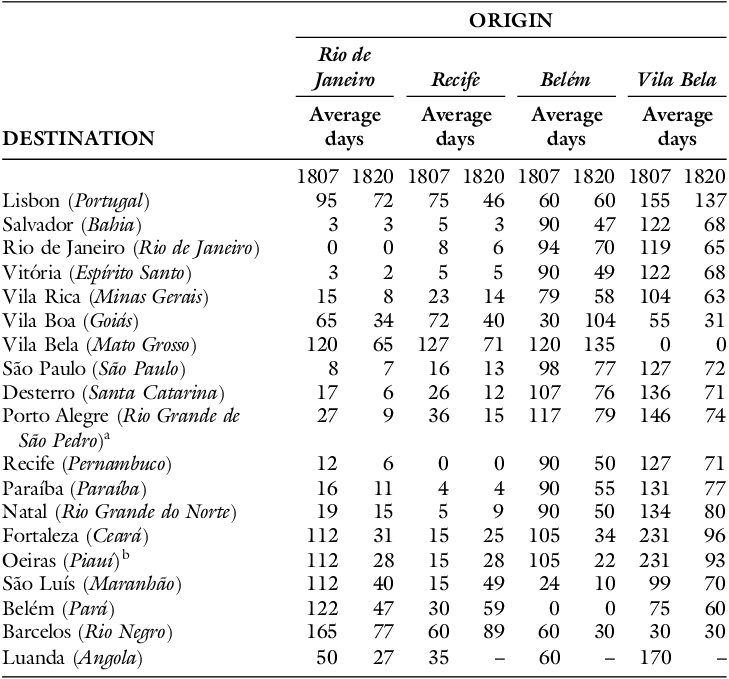
Not only did the network increase the number of connections, diversify its spatiality, and expand its capillarity, but it also moved towards the continent’s interior. It also amplified its asymmetries. That is, the centrality of Rio de Janeiro was relatively higher than Lisbon’s centrality in previous years. Not only did postal system connectivity change, but temporal distances were also shortened (Table 3).
Approximate Temporal Distances of Postal Communications in Portuguese Empire (1807–1820)

Table 3 Long description
The table presents the average days of postal communications between various cities in the Portuguese Empire for the years 1807 and 1820. The table has 16 rows and 8 columns. The columns are labeled with the origin cities: Rio de Janeiro, Recife, Belém, and Vila Bela, each with two sub-columns for the years 1807 and 1820. The rows are labeled with the destination cities. Each cell contains the average days it took for postal communications to travel from the origin to the destination. Row 1: Lisbon (Portugal), Average days: Rio de Janeiro 95, 72; Recife 75, 46; Belém 60, 60; Vila Bela 155, 137. Row 2: Salvador (Bahia), Average days: Rio de Janeiro 3, 3; Recife 5, 3; Belém 90, 47; Vila Bela 122, 68. Row 3: Rio de Janeiro (Rio de Janeiro), Average days: Rio de Janeiro 0, 0; Recife 8, 6; Belém 94, 70; Vila Bela 119, 65. Row 4: Vitória (Espírito Santo), Average days: Rio de Janeiro 3, 2; Recife 5, 5; Belém 90, 49; Vila Bela 122, 68. Row 5: Vila Rica (Minas Gerais), Average days: Rio de Janeiro 15, 8; Recife 23, 14; Belém 79, 58; Vila Bela 104, 63. Row 6: Vila Boa (Goiás), Average days: Rio de Janeiro 65, 34; Recife 72, 40; Belém 30, 104; Vila Bela 55, 31. Row 7: Vila Bela (Mato Grosso), Average days: Rio de Janeiro 120, 65; Recife 127, 71; Belém 120, 135; Vila Bela 0, 0. Row 8: São Paulo (São Paulo), Average days: Rio de Janeiro 8, 7; Recife 16, 13; Belém 98, 77; Vila Bela 127, 72. Row 9: Desterro (Santa Catarina), Average days: Rio de Janeiro 17, 6; Recife 26, 12; Belém 107, 76; Vila Bela 136, 71. Row 10: Porto Alegre (Rio Grande de São Pedro), Average days: Rio de Janeiro 27, 9; Recife 36, 15; Belém 117, 79; Vila Bela 146, 74. Row 11: Recife (Pernambuco), Average days: Rio de Janeiro 12, 6; Recife 0, 0; Belém 90, 50; Vila Bela 127, 71. Row 12: Paraíba (Paraíba), Average days: Rio de Janeiro 16, 11; Recife 4, 4; Belém 90, 55; Vila Bela 131, 77. Row 13: Natal (Rio Grande do Norte), Average days: Rio de Janeiro 19, 15; Recife 5, 9; Belém 90, 50; Vila Bela 134, 80. Row 14: Fortaleza (Ceará), Average days: Rio de Janeiro 112, 31; Recife 15, 25; Belém 105, 34; Vila Bela 231, 96. Row 15: Ociras (Piauí), Average days: Rio de Janeiro 112, 28; Recife 15, 28; Belém 105, 22; Vila Bela 231, 93. Row 16: São Luís (Maranhão), Average days: Rio de Janeiro 112, 40; Recife 15, 49; Belém 24, 10; Vila Bela 99, 70. Row 17: Belém (Pará), Average days: Rio de Janeiro 122, 47; Recife 30, 59; Belém 0, 0; Vila Bela 75, 60. Row 18: Barcelos (Rio Negro), Average days: Rio de Janeiro 165, 77; Recife 60, 89; Belém 60, 30; Vila Bela 30, 30. Row 19: Luanda (Angola), Average days: Rio de Janeiro 50, 27; Recife 35, 60; Belém 60, 170.
Source: see appendix.
Due to this acceleration, the shape of the time topology structure shifted. The space-time compressions were aligned with the state’s policy of increasing communication networks to respond to a rapidly changing world. By speeding up postal circulation and shortening distances, the empire’s administrators were creating new conditions for cohesion and territorial integration between the monarchy’s domains. It was a question of building a new time topology of communication, compatible with a state policy that aimed to react at the same pace as historical events, which seemed to be accelerating at an unprecedented rate.Footnote 56
A milestone in the debates on the territorial cohesion of Portuguese America was Brazil’s elevation to the status of a kingdom, united with Portugal and the Algarves, in December 1815, after the end of the Napoleonic Wars and at a period of reshaping international relations. This decision transformed Brazil into a political entity with more precise territorial boundaries and a more defined political center. Although it frustrated the Portuguese in Europe, this decision sought to avoid a fate similar to the collapse of the Spanish empire in America. The expansion of the postal network was seen as a tool for promoting territorial cohesion.Footnote 57 Although this space-time compression was not caused entirely by the post office, the postal system was one of its major driving forces.
Rio de Janeiro became more interconnected with the world, and the opportunities for maritime communications increased. However, significant changes were occurring inside Portuguese America. Rio became closer to all Luso-American capitals. For instance, before the postal reforms, Belém was 122 days away, a similar time distance to China. In 1820, this space-time was shortened to 47 days, almost three times faster (Figure 10).Footnote 58
Rio de Janeiro at the Postal Time Topology—1820.
Source: Thomáz Fortunato, Topologias do tempo, 301–302.

Figure 10 Long description
A scatter plot displays geodesic locations marked with black dots, spacetime locations with open circles, and a point of reference with a gray circle. Displacement vectors are represented by arrows connecting these points. The plot covers a geographical area, likely representing maritime communication routes. The x-axis and y-axis represent geographical coordinates, with values estimated. Clusters of points and vectors indicate increased connectivity and reduced travel times between locations. The overall trend shows a significant reduction in travel time between specific points, such as Rio de Janeiro and Belm, from 122 days to 47 days. All values are approximated.
Something slightly different occurred in Recife. Although Pernambuco’s capital got closer to almost all of the other cities, it moved away from Rio Grande do Norte, Ceará, Piauí, Maranhão, Pará, and Rio Negro. This was caused by the deactivation of the northern maritime postal line after 1808. In other words, the regular postal service between Recife and the western captaincies became terrestrial, thereby decreasing the speed of communication (Figure 11).
Pernambuco at the Postal Time Topology—1820.
Source: Thomáz Fortunato, Topologias do tempo, 315.

Figure 11 Long description
A scatter plot illustrating geodesic and spacetime locations with displacement vectors. The plot features numerous data points marked by black circles and one gray circle, representing a point of reference. Arrows indicate displacement vectors originating from these points. The x-axis and y-axis represent geographical coordinates, with values estimated. Clusters and patterns are visible, showing the movement and displacement of locations over time. The overall trend indicates varying degrees of proximity and distance between locations. All values are approximated.
Belém also became closer to almost all other captaincies’ capitals, except Goiás and Mato Grosso. This was due to the fact that, after the reforms, the postal itinerary between Pará and the southern cities changed. Pará and Goiás were no longer directly connected; the letters had to go through Minas Gerais or Rio de Janeiro, taking a longer detour to reach their destination (Figure 12).
Para at the Postal Time Topology—1820.
Source: Thomáz Fortunato, Topologias do tempo, 324.

Figure 12 Long description
A scatter plot illustrates the postal routes and changes in Brazil during 1820. The plot features numerous data points representing geodesic locations (solid circles) and spacetime locations (open circles), with a point of reference (gray circle) and displacement vectors (arrows) indicating changes in postal routes. The x-axis represents longitude, and the y-axis represents latitude. The plot shows clusters of data points along the eastern coast of Brazil, with notable changes in routes connecting Par and other southern cities. After reforms, the postal itinerary between Par and Gois is no longer direct; letters now go through Minas Gerais or Rio de Janeiro, taking a longer detour. The plot highlights the impact of these reforms on the postal network, with a clear shift in the connectivity of various regions. All values are approximated.
Finally, Mato Grosso became closer to all of the other cities in Portuguese America. The most important change was that, when Lisbon was the imperial capital, political authorities had to wait at least five months for letters sent to be delivered to their destination; when Rio de Janeiro became the capital, this wait time fell to 65 days (Figure 13).
Mato Grosso at the Postal Time Topology—1820.
Source: Thomáz Fortunato, Topologias do tempo, 328.

Figure 13 Long description
A scatter plot displays geodesic locations marked with black dots, spacetime locations with open circles, and a point of reference with a gray circle. Displacement vectors are represented by arrows. The plot covers parts of South America, North America, and Europe. The x-axis and y-axis represent geographical coordinates. Clusters of data points are visible along the eastern coast of South America and in the northeastern part of North America. The plot shows the relationship between different locations and their displacement vectors over time. All values are approximated.
Combined with the shortening of distances, the improvement of postal regularity shaped the conditions for a new space-time structure. In June 1809, D. João ordered a postal connection between Rio de Janeiro and Lisbon every two months, or if there were enough vessels, every month. In 1810, sea mail between the new seat of the Crown and Great Britain was made official, as part of the trade agreements, with a British liner leaving Falmouth every month. During this same period, the Mercúrio and Boaventura sea couriers, which regularly connected Lisbon and Rio, operated at an average interval of one and a half months. Shortly afterwards, the 40-day interval for this postal route was set. The number of commercial vessels carrying mail increased with the opening of the ports, and, according to the advertisements in the Gazeta do Rio de Janeiro, between 1809 and 1820, the monthly average of ships carrying letters from the port of Rio de Janeiro was seventeen.Footnote 59
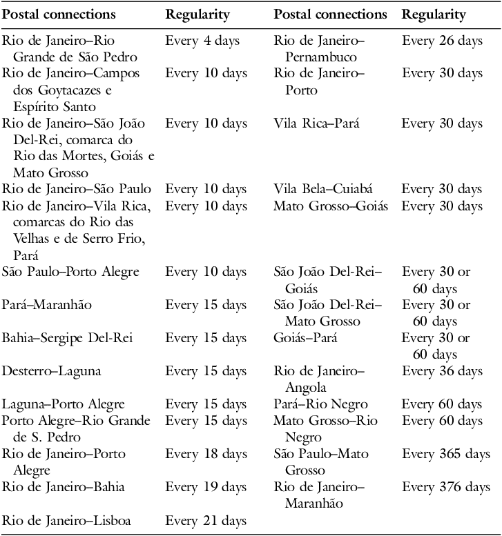
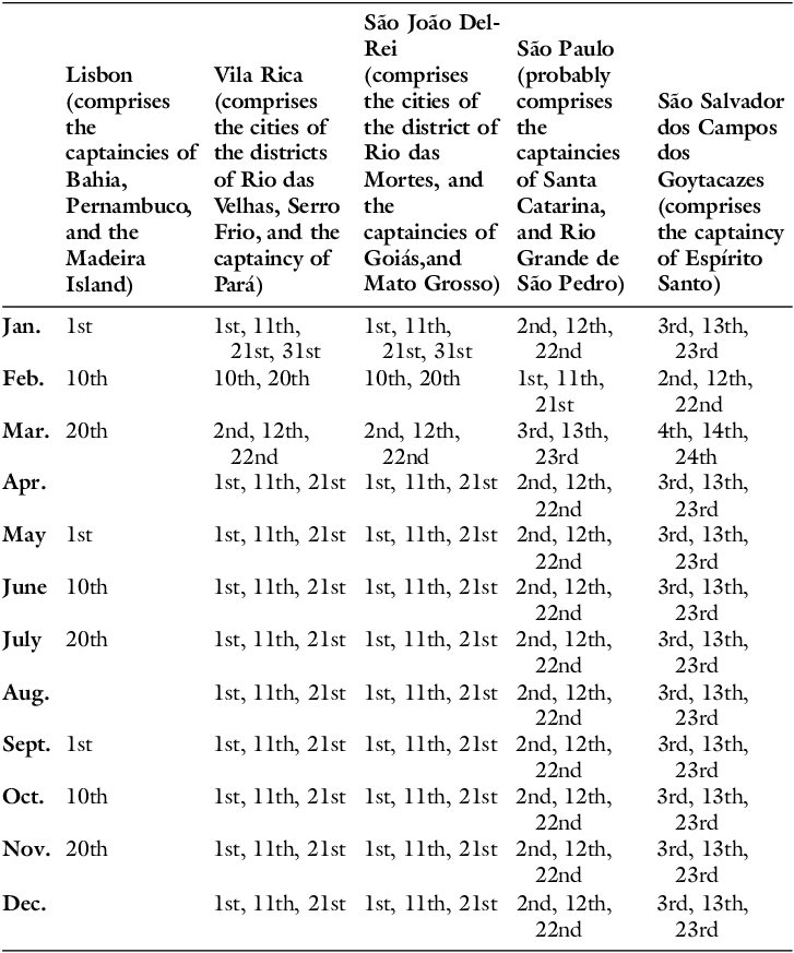
On land, the postal calendars grew in number and detail. In 1809, the dispatch of correspondence from the Royal Court to the City of São Paulo ceased to be monthly. It began to take place every two weeks, the exact interval for the connections between Rio and Goytacazes. The bimonthly frequency of the Royal Court’s communication with Minas Gerais became weekly, and then stabilized at 10 days. In 1810, postal flows between Minas Gerais, Goiás, Mato Grosso, and Pará became monthly, and at most every two months. That same year, mail from the Court to São Paulo and Campos was accelerated again to a 10-day interval, and, simultaneously, new destinations were added to the post line. In 1811, Salvador’s couriers left every month for Rio de Janeiro and Maranhão, and every two weeks a courier was dispatched to Sergipe and its surroundings. In 1816, mail from São Paulo to Rio Grande de São Pedro began to be sent every 10 days, coinciding with the new frequency of mail departures from the Royal Court to multiple destinations (Tables 4 and 5). Comparing the data from Tables 2, 4, and 5, it can be seen that postal communications had increased.Footnote 60
Post Office Approximate Regularity (c. 1810–1820)a

Table 4 Long description
The table presents postal connections and their regularity between various locations. It has two sections, each with two columns: Postal connections and Regularity. The first section lists connections and their regularity as follows: Rio de Janeiro-Rio Grande de So Pedro every 4 days, Rio de Janeiro-Campos dos Goytacazes and Espirito Santo every 10 days, Rio de Janeiro-So Joao Del-Rei, comarca do Rio das Mortes, Goias and Mato Grosso every 10 days, Rio de Janeiro-So Paulo every 10 days, Rio de Janeiro-Vila Rica, comarcas do Rio das Velhas and de Serro Frio, Para every 10 days, So Paulo-Porto Alegre every 10 days, Para-Maranhao every 15 days, Bahia-Sergipe Del-Rei every 15 days, Desterro-Laguna every 15 days, Laguna-Porto Alegre every 15 days, Porto Alegre-Rio Grande de S. Pedro every 15 days, Rio de Janeiro-Porto Alegre every 18 days, Rio de Janeiro-Bahia every 19 days, Rio de Janeiro-Lisboa every 21 days. The second section lists connections and their regularity as follows: Rio de Janeiro-Pernambuco every 26 days, Rio de Janeiro-Porto every 30 days, Vila Rica-Par every 30 days, Vila Bela-Cuiaba every 30 days, Mato Grosso-Goias every 30 days, So Joao Del-Rei-Goias every 30 or 60 days, So Joao Del-Rei-Mato Grosso every 30 or 60 days, Goias-Par every 30 or 60 days, Rio de Janeiro-Angola every 36 days, Rio de Janeiro-Maranhao every 376 days, Para-Rio Negro every 60 days, Mato Grosso-Rio Negro every 60 days, So Paulo-Mato Grosso every 365 days.
Source: see appendix.
Rio de Janeiro’s Postal Calendar (1810–1820)

Table 5 Long description
The table presents the postal calendar for various regions in Brazil from 1810 to 1820. It includes the following columns: Lisbon, Vila Rica, Sao Joao Del-Rei, Sao Paulo, and Sao Salvador dos Campos. Each column lists specific dates when postal services were available. The table has 12 rows, each representing a month from January to December. Each row lists the dates when postal services were available for each region. For example, in January, Lisbon had postal services on the 1st, Vila Rica on the 1st, 11th, 21st, and 31st, Sao Joao Del-Rei on the 1st, 11th, 21st, and 31st, Sao Paulo on the 2nd, 12th, and 22nd, and Sao Salvador dos Campos on the 3rd, 13th, and 23rd.
Source: see appendix.
An individual based in Rio de Janeiro around January 1811 would witness, for example, the departure of mail on the 1st, 2nd, 3rd, 11th, 12th, 13th, 21st, 22nd, 23rd, and 31st days of the month. On the 1st, he would see three different departures, on the 11th, 21st, and 31st days, two different departures to more than twenty different destinations. If the movement of commercial vessels was average, it could still count around seventeen ships, capable of transporting correspondence, leaving on different dates and destined for almost fifty different places. The Luso-American postal space had gained not only in speed, regularity, and frequency, but also in diversity. The postal network thickened its coverage and strengthened integration between different territorial scales. This certainly broadened the horizon of information available to people at the time, tying together postal geography with new imagined spaces that were increasingly global.Footnote 61
Final Remarks: Time, Politics, Communication, and the Crossing of a Distance
In the midst of the political conflicts in Europe, the Portuguese monarchy decided to establish a new system of regular long-distance communication with its American colonies. After all, by the end of the eighteenth century, preserving them had become an unavoidable issue for Portugal’s economic and geopolitical sustainability. Like any empire with vast territorial possessions, the circulation of writing played a pivotal role in the government and administration of the state. In response to tensions in the colonial world, the regularity, frequency, and speed of communication became essential factors in the empire’s politics. Through them, parts of the monarchy were more connected. The Luso-American postal network strengthened territorial integration at the “local,” “regional,” “Luso-American,” and “imperial” scales.
Following the transfer of the metropolis to Portuguese America, the postal network was used to build Rio de Janeiro’s centrality. Along with the empire’s gravitational shift, a new postal geography was constructed. The expansion of the network, the shortening of distances, the intensification of connection frequencies, and the diversification of destinations were encouraged by political and commercial demands. These efforts were undertaken to address the challenges posed by the accelerating pace of global change, which imposed significant demands on rulers and economic agents.
In the first decades of the nineteenth century, the slowness and uncertainty of communications became synonymous with weaknesses in state sovereignty and obstacles to economic development. For this reason, speeding up the crossing of distances, reducing the wait times between postal dispatch, and expanding the places covered by the communications network were different facets of the same process: space-time compression was structured through a new time topology of communications, and the postal system was one of its main factors.
The acceleration produced was not the result of technological innovations, but rather of new ways of organizing the information flow. This process contributed to the transformation of economic, political, and social units in Portuguese America, whose plural geography of overlapping and dynamic spaces, shaped by conflicts and harmonies, was partially articulated by the postal network. Furthermore, it also constitutes a means of diagnosing a concrete acceleration of historical time, intrinsically tied to the social perception of acceleration, but rooted in preindustrial spatial communication networks.
Historical data suggests that this phenomenon was not restricted to Brazil. Political revolutions tend to enhance changes in human relations with time, but also with space, insofar as the acceleration of time and the shortening of space seem to be two effects that shape different revolutionary experiences. In Guatemala and the Río de la Plata, the Bourbon Reforms of the eighteenth century accelerated postal communications. In Chile, letters that used to arrive from Madrid every two years began to come four times a year. In the United States, in 1789, a letter sent from Maine to Georgia would take 40 days; in 1810, the interval was reduced to 27 days; and in 1839, it took only 12 days. This was also the case with Brazil’s independence revolution: the postal infrastructure that served the territorial integration of the Portuguese empire between 1800 and 1820 conditioned the space-time of the crisis that culminated in the political rupture of 1822; that is, the regularity in an accelerated space-time—grounded in a network space—shaped the conditions in which the independence revolution occurred.Footnote 62
While under the authority of the Portuguese monarchy, the postal service helped to consolidate the colonial empire. The geography of these reforms and the structure of the postal network were reciprocally conditioned. However, as the fissures of that state widened, reaching a critical point in 1820, different groups disputed the postal geography to the point that its morphology became a factor in the dynamics of the Independence Wars. During the conflicts that unfolded after the Porto Revolution and the opening of the Lisbon Courts, tensions between the political authorities of the monarchy intensified, fragmenting the exercise of power among regional actors, the Lisbon Courts, and the Rio de Janeiro Court.Footnote 63
By combining these examples and connecting them to the broader transformations that the Western World was experiencing at the turn of the eighteenth and nineteenth centuries, we can reframe the chronology and the geography of the world’s shrinking process.Footnote 64 Although the history of humankind has witnessed many specific cases of accelerated communication, the Age of Revolutions transformed acceleration into a fundamental characteristic of an increasing number of economic, social, political, and cultural processes.Footnote 65 In this period, short-term events were able to modify important long-term structures, which in turn conditioned the very emergence of these events.Footnote 66 One of these structures was the space-time fabric of communications, and, in consequence, other historical dimensions linked to it. In this sense, the space-time compression enabled by the postal network can be considered part of the globalization of an accelerated time, one of its foundations being the shortening of distances.Footnote 67
For these reasons, the history of postal communications offers a perspective for research on the social experience of time and space. The history of space-time compressions is also part of the rise of a modern temporality. Suppose modern time leads to a divergence between “space of experience” and “horizon of expectation,” as Koselleck defines it. In that case, a topology of time that allows a greater quantity of news, letters, and documents to move regularly faster to an increasing number of different places, then time acceleration must have its spatial counterpart.Footnote 68
This space-time network structure increases the synchronicity between events and their representation as news, thereby making available a larger, more geographically diverse, and more recent volume of experiences that are being interpreted as signs of a temporal acceleration. As part of this process, the spatial scales of social experiences are becoming more comprehensive, plural, and interconnected. This represents a new way of grounding the understanding of the modern experience of time, interweaving it with a modern experience of space, which points to a growing tendency towards interconnectedness that fosters the globalization of the modern experience of time.
Crisis and revolution appear in the consciousness of historical subjects not only as the loss of the operability of the forms of reproduction of social life, fostering a sense of acceleration toward the future,Footnote 69 but also as a dissonance between the space-time of communications and the time of politics. For this reason, the history of time acceleration has its complement in the rise of a topological space, as the bending of space-time, materialized in the postal network, consists in the forging of a new space tied to the experience of a new time.
These conclusions about the history of the postal network revise and refine our understanding of Brazilian politics in the late eighteenth and early nineteenth centuries in three significant ways. First, they demonstrate the importance of communications infrastructure in shaping the government of a changing political body. Second, they highlight how the development of the postal network was linked to the expansion of the state’s territorial control. Third, they underscore the importance of the postal network for disseminating information and promoting political stability. In other words, the postal network served to mediate the dialectics between state, nation, and territory amid the modernization of their means of exercising authority. This process led to the emergence of a novel spatiotemporal fabric that is intrinsically tied to the postal network.
Appendix
Graph 1 sources: D. Rodrigo de Sousa Coutinho (April 24, 1799), “Do Secretário de Estado sobre a Comunicação desta Capitania com a de Mato Grosso e Goyazes,” D. Rodrigo de Sousa Coutinho (January 8, 1800), “Do dito Secretário de Estado sobre o General não consentir sair embarcação alguma do porto desta capital sem levar as malas do correio etc.,” Documentos Interessantes para a História e Costumes de São Paulo 89 (São Paulo: Arquivo do Estado de São Paulo, 1967), 152, 201–202; Antônio Manoel de Mello Castro e Mendonça (February 22, 1800), “Para o dito Secretário de Estado sobre remeter por cópia e seus documentos o ofício que dirige à Junta da Fazenda a Sua Alteza, dando conta do estabelecimento do Correio, rendimento, etc.,” Documentos Interessantes para a História e Costumes de São Paulo 29 (São Paulo: Arquivo do Estado de São Paulo, 1967), 198–199; Antônio Manoel de Mello Castro e Mendonça (November 15, 1800), “Para o Secretário de Estado participando o modo com que executou o Aviso de 24 de abril relativo aos correios,” Documentos Interessantes para a História e Costumes de São Paulo 30 (São Paulo: Arquivo do Estado de São Paulo, 1967), 7–8; Antônio Manoel de Mello Castro e Mendonça (January 13, 1799), “Para o excelentíssimo Vice-rei do Estado,” Antônio Manoel de Mello Castro e Mendonça (September 24, 1800), “Para o mesmo general,” Conde de Resende (February 7, 1799), “Do Excelentíssimo Vice-rei do Estado” Documentos Interessantes para a História e Costumes de São Paulo 39 (São Paulo: Arquivo do Estado de São Paulo, 1967), 14–16, 41–45, 166–167; “Alvará e Instruções de janeiro e fevereiro de 1798 para o estabelecimento dos correios,” Arquivo Nacional, BR RJANRIO COD. 0. 67, v. 23; D. Rodrigo de Sousa Coutinho (December 1, 1800), “Aviso a D. Fernando José de Portugal,” Arquivo Nacional, BR RJANRIO COD. 0. 67, v. 26; D. João (July 8, 1800), “Instruções para D. Fernando José de Portugal,” Arquivo Nacional, BR RJANRIO 86. COD. 0. 67, v. 25; D. Rodrigo de Sousa Coutinho (September 27, 1796), “Circular aos governadores da América,” Arquivo Nacional, BR RJANRIO COD. 0. 67, v. 21; D. Miguel Antônio de Melo (December 7, 1798), “Instruções para o estabelecimento de correios em Angola,” Arquivo Nacional, BR RJANRIO D9, Cx. 746, Pct. 01; João Carlos Corrêa Lemos (November 11, 1798), “Ofício sobre os correios de Desterro, Laguna, Rio São Francisco etc.,” Arquivo Nacional, BR RJANRIO D9, Cx. 486, Pct. 03; Conde de Resende (August 11, 1798), “Ofício para Bernardo José de Lorena,” Biblioteca Nacional, BNRJ I-26, 31, 080; D. Rodrigo de Sousa Coutinho (July 31, 1799), “Ofício para Francisco de Sousa Coutinho acusando as informações referentes às riquezas naturais da Bahia, Pernambuco e Ceará etc.,” Biblioteca Nacional, BNRJ I-28, 28, 033; Caetano Pinto de Miranda Montenegro (March 8, 1799), “Ofício para D. Rodrigo de Sousa Coutinho com anexos,” Arquivo Histórico Ultramarino, AHU_ACL_CU_010, Cx. 36, doc. 1844; Conde de Resende (September 13, 1798), “Ofício para D. Rodrigo de Sousa Coutinho,” Arquivo Histórico Ultramarino, AHU_ACL_CU_017, Cx. 166, doc. 12341; Conde de Resende (May 27, 1799), “Ofício para D. Rodrigo de Sousa Coutinho,” Arquivo Histórico Ultramarino, AHU_ACL_CU_017, Cx. 171, doc. 12691; Antônio Januário do Vale (November 29, 1799), “Ofício para D. Rodrigo de Sousa Coutinho,” Arquivo Histórico Ultramarino, AHU_ACL_CU_017, Cx. 177, doc. 13021; Antônio Januário do Vale (December 17, 1799), “Ofício para D. Rodrigo de Sousa Coutinho,” Arquivo Histórico Ultramarino, AHU_ACL_CU_017, Cx. 178, doc. 13058; Conde de Resende (November 19, 1798), “Ofício para D. Rodrigo de Sousa Coutinho,” Arquivo Histórico Ultramarino, AHU_ACL_CU_017, Cx. 168, doc. 12474; Conde de Resende (May 30, 1799), “Ofício para D. Rodrigo de Sousa Coutinho,” Arquivo Histórico Ultramarino, AHU_ACL_CU_017, Cx. 171, doc. 12713; Conde de Resende (December 15, 1799), “Ofício para D. Rodrigo de Sousa Coutinho,” Arquivo Histórico Ultramarino, AHU_ACL_CU_017, Cx. 178, doc. 13051; Conde de Resende (September 27, 1799), “Ofício para D. Rodrigo de Sousa Coutinho,” Arquivo Histórico Ultramarino, AHU_ACL_CU_017, Cx. 175, doc. 12891; Bernardo José de Lorena (August 22, 1798), “Ofício para D. Rodrigo de Sousa Coutinho,” Arquivo Histórico Ultramarino, AHU_ACL_CU_011, Cx. 145, doc. 26; Fernando José de Portugal (December 23, 1797), “Ofício para D. Rodrigo de Sousa Coutinho,” Arquivo Histórico Ultramarino, AHU_ACL_CU_005, Cx. 90, doc. 17551; Fernando José de Portugal (April 30, 1798), “Ofício para D. Rodrigo de Sousa Coutinho,” Arquivo Histórico Ultramarino, AHU_ACL_CU_005, Cx. 93, doc. 18259; Fernando José de Portugal (June 3, 1798), “Ofício para D. Rodrigo de Sousa Coutinho,” Arquivo Histórico Ultramarino, AHU_ACL_CU_005, Cx. 94, doc. 18336; Fernando José de Portugal (September 11, 1798), “Ofício para D. Rodrigo de Sousa Coutinho,” Arquivo Histórico Ultramarino, AHU_ACL_CU_005, Cx. 94, doc. 18375; Fernando José de Portugal (July 22, 1799), “Ofício para D. Rodrigo de Sousa Coutinho (anexos),” Arquivo Histórico Ultramarino, AHU_ACL_CU_005, Cx. 96, doc. 18732; Fernando José de Portugal (March 20, 1798), “Ofício para D. Rodrigo de Sousa Coutinho,” Arquivo Histórico Ultramarino, AHU_ACL_CU_005, Cx. 93, doc. 18151; Antônio de Melo Castro e Mendonça (August 3, 1798), “Ofício para D. Rodrigo de Sousa Coutinho,” Arquivo Histórico Ultramarino, AHU_ACL_CU_023-01, Cx. 44, doc. 3507; Antônio Manuel de Melo Castro e Mendonça (January 31, 1799), “Ofício para D. Rodrigo de Sousa Coutinho,” Arquivo Histórico Ultramarino, AHU_ACL_CU_023-01, Cx. 47, doc. 3641; Antônio de Melo Castro e Mendonça (January 28, 1800), “Ofício para D. Rdrigo de Sousa Coutinho,” Arquivo Histórico Ultramarino, AHU_ACL_CU_023-01, Cx. 49, doc. 3861; Antônio Manuel de Melo Castro e Mendonça (February 7, 1799), “Ofício para o conde de Resende,” Arquivo Histórico Ultramarino, AHU_ACL_CU_023-01, Cx. 49, doc. 3888; Francisco de Sousa Coutinho (May 10, 1797), “Ofício para D. Rodrigo de Sousa Coutinho,” Arquivo Histórico Ultramarino, AHU_ACL_CU_013, Cx. 109, doc. 8578; Thomaz José de Melo (April 17, 1798), “Ofício para D. Rodrigo de Sousa Coutinho,” Arquivo Histórico Ultramarino, AHU_ACL_CU_015, Cx. 201, doc. 13761; Thomaz José de Melo (August 8, 1798), “Ofício para D. Rodrigo de Sousa Coutinho,” Arquivo Histórico Ultramarino, AHU_ACL_CU_015, Cx. 203, doc. 13858; Thomaz José de Melo (August 8, 1798), “Ofício para D. Rodrigo de Sousa Coutinho,” Arquivo Histórico Ultramarino, AHU_ACL_CU_015, Cx. 203, doc. 13857; Maximiano Francisco Duarte (February 9, 1799), “Ofício para D. Rodrigo de Sousa Coutinho,” Arquivo Histórico Ultramarino, AHU_ACL_CU_015, Cx. 206, doc. 14039; Junta Governativa de Pernambuco (July 31, 1799), “Ofício para D. Rodrigo de Sousa Coutinho,” Arquivo Histórico Ultramarino, AHU_ACL_CU_015, Cx. 209, doc. 14190; Fernando Antônio de Noronha (May 6, 1798), “Ofício para D. Rodrigo de Sousa Coutinho,” Arquivo Histórico Ultramarino, AHU_ACL_CU_009, Cx. 98, doc. 7929; Caetano da Silva Sanches (August 17, 1798), “Ofício para D. Rodrigo de Sousa Coutinho,” Arquivo Histórico Ultramarino, AHU_ACL_CU_003, Cx. 30, doc. 2477; Thomaz José de Melo (July 12, 1797), “Carta à Rainha D. Maria I,” Arquivo Histórico Ultramarino, AHU_ACL_CU_015, Cx. 197, doc. 13571; Conde de Resende (November 30, 1798), “Ofício para D. Rodrigo de Sousa Coutinho,” Arquivo Histórico Ultramarino, AHU_ACL_CU_017, Cx. 168, doc. 12484; Fernando José de Portugal (August 23, 1800), “Ofício para D. Rodrigo de Sousa Coutinho,” Arquivo Histórico Ultramarino, AHU_ACL_CU_005, Cx. 107, doc. 20816; Fernando José de Portugal (June 23, 1800), “Ofício para D. Rodrigo de Sousa Coutinho,” Arquivo Histórico Ultramarino, AHU_ACL_CU_005, Cx. 106, doc. 20724; Fernando José de Portugal (June 4, 1800), “Ofício para D. Rodrigo de Sousa Coutinho,” Arquivo Histórico Ultramarino, AHU_ACL_CU_005, Cx. 106, doc. 20599; D. João (July 7, 1800), “Instruções para o governador de São Paulo,” Arquivo Histórico Ultramarino, AHU_ACL_CU_023-01, Cx. 48, doc. 3825; Antônio Manuel de Melo Castro e Mendonça (September 24, 1800), “Ofício para D. Rodrigo de Sousa Coutinho,” Arquivo Histórico Ultramarino, AHU_ACL_CU_023, Cx. 16, doc. 786; Almanaque Geral do Império do Brasil (Rio de Janeiro: Tipografia Comercial Fluminense, 1838), 167.
Table 1 sources: D. Fernando José de Portugal (April 30, 1798), “Ofício para D. Rodrigo de Sousa Coutinho,” Arquivo Histórico Ultramarino, AHU_ACL_CU_005, Cx. 93, doc. 18259; D. Fernando José de Portugal (June 3, 1798), “Ofício para D. Rodrigo de Sousa Coutinho,” Arquivo Histórico Ultramarino, AHU_ACL_CU_005, Cx. 94, doc. 18336; D. Francisco Maurício de Sousa Coutinho (May 10, 1797), “Ofício D. Rodrigo de Sousa Coutinho”; Pedro Duarte da Silva (August 2, 1799), “Ofício para D. Rodrigo de Sousa Coutinho,” Arquivo Histórico Ultramarino, AHU_ACL_015, Cx. 209, doc. 14205; D. Tomás José de Melo (October 20, 1798), “Ofício para D. Rodrigo de Sousa Coutinho,” Arquivo Histórico Ultramarino, AHU_ACL_CU_015, cx. 204, doc. 13969; Junta Governativa da capitania de Pernambuco (July 31, 1799), “Ofício para D. Rodrigo de Sousa Coutinho,” Arquivo Histórico Ultramarino, AHU_ACL_CU_015, Cx. 209, doc. 14190; Comandante do Correio Boa Ventura (November 17, 1802),“Ofício para D. João Rodrigues de Sá e Melo,” Arquivo Histórico Ultramarino, AHU_ACL_CU_017, Cx. 123, doc. 9486; Comandante do Correio Paquete Real (December 20, 1801), “Ofício para D. João Rodrigues de Sá e Melo,” Arquivo Histórico Ultramarino, AHU_ACL_CU_003, Cx. 33, doc. 2728; “Conta corrente dos correios marítimos do ano de 1800” (January 16, 1800), Arquivo Nacional, BR RJANRIO 0. 0. 0634053; Bernardo José de Lorena (August 22, 1798), “Ofício para D. Rodrigo de Sousa Coutinho,” Arquivo Histórico Ultramarino, AHU_ACL_CU_011, Cx. 145, doc. 26; D. Fernando José de Portugal (April 30, 1798), “Ofício para D. Rodrigo de Sousa Coutinho”; John Mawe, Viagens ao interior do Brasil (Belo Horizonte, São Paulo: Itatiaia, Edusp, 1978); “Manda estabelecer um Correio regular entre as Províncias de S. Pedro do Rio Grande e de S. Paulo,” Coleção das Leis do Brasil: Cartas de Lei, Alvarás, Decretos e Cartas Régias de 1817 (Rio de Janeiro: Imprensa Nacional, 1890), 61–65; Junta Governativa da capitania de Pernambuco (July 31, 1799), “Ofício para D. Rodrigo de Sousa Coutinho”; Comandante do Correio Boa Ventura (November 17, 1802), “Ofício para D. João Rodrigues de Sá e Melo”; Silvana A. de Godoy, “Itu e Araritaguaba na rota das monções (1781–1838),” Anais do V Congresso Brasileiro de História Econômica da Associação Brasileira de Pesquisadores em História Econômica (Belo Horizonte: ABPHE, 2003), 22.
Table 2 sources: Francisco Maurício de Sousa Coutinho (May 10, 1797), “Ofício para D. Rodrigo de Sousa Coutinho”; Bernardo José de Lorena (August 22, 1798), “Ofício para D. Rodrigo de Sousa Coutinho”; D. Miguel Antônio de Melo (December 7, 1798), “Bando e instruções para o estabelecimento dos correios no Reino de Angola,” Arquivo Nacional, BR RJANRIO D9, Cx. 746, Pct. 01; “Alvará para o estabelecimento dos correios na América” (January 20, 1798), Arquivo Nacional, BR RJANRIO COD. 0. 67, v. 23; Caetano Pinto de Miranda Montenegro (March 8, 1799), “Ofício para D. Rodrigo de Sousa Coutinho”; Almanaque Geral do Império do Brasil, 167; “Parecer sobre o estabelecimento do correio na Ilha de Santa Catarina” (July 3, 1798), Arquivo Nacional, BR RJANRIO D9, Cx. 486, Pct. 03; Documentos Interessantes para a História e Costumes de São Paulo 33 (São Paulo: Typographia do Diário Oficial, 1901), 75–76; Silvana Godoy, “Itu e Araritaguaba na rota das monções (1718–1838),” Anais do V Congresso Brasileiro de História Econômica, 1-25; Manoel de Figueiredo (October 4, 1801), “Ofício para D. Rodrigo de Sousa Coutinho,” Arquivo Nacional, BR RJANRIO COD. 67, v. 28; Caetano Pinto de Miranda Montenegro (March 8, 1799), “Ofício para D. Rodrigo de Sousa Coutinho,” Arquivo Histórico Ultramarino, AHU_ACL_CU_010, Cx. 36, doc. 1844; Conde de Resende (August 11, 1798), “Ordem para Bernardo José de Lorena,” Biblioteca Nacional, BNRJ I-26, 31, 080; Bernardo José de Lorena (August 22, 1798), “Ofício para D. Rodrigo de Sousa Coutinho”; Conde de Resende (May 27, 1799), “Ofício para D. Rodrigo de Sousa Coutinho,” Arquivo Histórico Ultramarino, AHU_ACL_CU_017, Cx. 171, doc. 12691. There is a more detailed version in Thomáz Fortunato, Topologias do tempo.
Graph 2 sources: “Decisão sobre os correios da Capitania de Minas Gerais,” 10–15; “Aprova o estabelecimento de Correios entre as principais vilas da Capitania do Ceará e a de Pernambuco,” 40; “Manda que o estabelecimento do Correio da Província do Ceará passe a ficar debaixo da jurisdição e fiscalização da Real Junta da Fazenda como mais um ramo da Renda Real,” Coleção de Leis do Brasil. Decisões de 1820 (Rio de Janeiro: Imprensa Nacional, 1889), 44–45; “Manda estabelecer correios entre as diversas províncias deste Reino,” 26; Almanaque Geral do Império do Brasil, 167; “Nomeia o administrador do Correio estabelecido entre as províncias de S. Pedro do Rio Grande do Sul e de S. Paulo,” “Manda estabelecer um Correio regular entre as Províncias de S. Pedro do Rio Grande e de S. Paulo,” 60–65; “Manda executar o Regulamento para o estabelecimento de um correio entre esta corte e a colônia dos suíços do Morro-Queimado,” 4–8; Comandante do Corpo da Marinha de Guerra (June 3, 1809), “Ofício para o governador do Reino e secretário da Marinha e Ultramar”; “Decisão sobre os correios da Capitania de Minas Gerais,” 10–15; “Ratifica a convenção entre o Príncipe Regente de Portugal e El Rei do Reino Unido da Grã-Bretanha,” 73–76; O Patriota 2 (August 1813), 66–69; “Manda estabelecer o Correio Militar para o Rio Grande do Sul,” 81; “Estabelece correios marítimos entre esta Corte, e os principais portos deste Continente com os do Reino de Portugal e Ilha da Madeira,” 26; “Parecer sobre o estabelecimento do correio na Ilha de Santa Catarina” (July 3, 1798); Almanaque Geral do Império do Brasil, 167.
Table 3 sources: “Visita do ouro a dois brigues” (September 28, 1809), Arquivo Nacional, AHU_ACL_CU_017, Cx. 255, doc. 17429; “Visita do ouro no correio marítimo Boaventura” (April 8, 1811), Arquivo Nacional AHU_ACL_CU_017, Cx. 261, doc. 17911; Conde das Galveas (February 2, 1811), “Lista de avisos do secretário de Estado da Marinha e Ultramar,” Arquivo Histórico Ultramarino, AHU_ACL_CU_003, Cx. 41, doc. 3280; Conde das Galveas (April 7, 1811), “Lista de avisos do secretário de Estado da Marinha e Ultramar,” Arquivo Histórico Ultramarino, AHU_ACL_CU_003, Cx. 41, doc. 3283; Pedro Duarte da Silva (May 4, 1815), “Ofício para D. Miguel Pereira Forjaz Coutinho,” Arquivo Nacional, AHU_ACL_CU_003, Cx. 42, doc. 3361; “Visita do ouro em charrua” (March 20, 1819), Arquivo Nacional, AHU_ACL_CU_017, Cx. 281, doc. 19712; José Vicente Caldeira de Casal Ribeiro (April 26, 1819), “Ofício para D. Miguel Pereira Forjaz Coutinho,” Arquivo Nacional, AHU_ACL_CU_003, Cx. 43, doc. 3487; José Vicente Caldeira de Casal Ribeiro (July 12, 1819), “Ofício para D. Miguel Pereira Forjaz Coutinho,” Arquivo Nacional, AHU_ACL_CU_003, Cx. 43, doc. 3503; John Mawe, Travels in the Interior of Brazil (London: Printed for Longman, Hurst, Rees, Orme, and Brown Paternoster-Row, 1812); Lenira Martinho and Riva Gorenstein, Negociantes e Caixeiros na sociedade da Independência (Rio de Janeiro: Secretaria Municipal de Cultura, Turismo e Esportes, 1993), 170–186; Thomáz Fortunato, Topologias do tempo, 299–300; Luiz Thomaz de Navarro, “Plano econômico e provisional,” 464–468; Auguste de Saint-Hilaire, Viagem ao Espírito Santo e Rio Doce (Belo Horizonte, São Paulo: Itatiaia, Edusp, 1974), 115–116; Auguste de Saint-Hilaire, Viagem à Província de São Paulo e resumo, 309–310; “Regulamento e instruções práticas para o estabelecimento do Correio entre a Corte e a nova Colônia dos Suíços” (January 3, 1820), Biblioteca Nacional, BNRJ 01,03,001 n. 187; “Manda executar o Regulamento para o estabelecimento de um correio entre esta corte e a colônia dos suíços do Morro-Queimado,” 4–8; Gazeta do Rio de Janeiro (April 8, 1820); “Termos de arrematação que fazem o tenente coronel José Vidal de Barbosa e o guarda mor José Caetano de Gouveia” (December 2, 1809), Biblioteca Nacional, BNRJ I-09,12,004 n. 3; Príncipe Regente D. João (November 26, 1809), “Ordem determinando os horários de partida dos correios”; “Mapa das vilas, arraiais, capelas e fazendas que há na estrada que vai de Vila Rica até o registro de Santa Maria da capitania de Goiás, e suas distâncias para passarem os correios da corte para a cidade do Pará, vindo do Rio de Janeiro até Vila Rica pelo correio ordinário e regressarem da cidade do Pará para a Corte” (March 30, 1809), Arquivo Nacional, BR RJANRIO AA. IJJ9-493; Fernando Delgado Freire de Castilho (December 29, 1810), “Ofício para o Conde de Aguiar,” Arquivo Nacional, BR RJANRIO AA. IJJ9-493; Manoel Jacinto Nogueira da Gama (January 27, 1809), “Ofício para o Conde de Linhares,” Arquivo Nacional, BR RJANRIO AA. IJJ9-493; D. Francisco de Assiz Mascarenhas (August 4, 1809), “Recaptulação das ordens do Conde de Aguiar,” Arquivo Nacional, BR RJANRIO AA. IJJ9-493; D. Francisco de Assiz Mascarenhas (June 20, 1808), “Ofício para D. Rodrigo de Sousa Coutinho,” Arquivo Nacional, BR RJANRIO AA. IJJ9-493; “Escalas de dois caminhos da Cidade do Rio de Janeiro ao Pará pela capitania de Goiás” (s.d.), Arquivo Nacional, BR RJANRIO AA. IJJ9-493; Joaquim Theotonio Segurado (June 17, 1808), “Ofício para D. Francisco de Assiz Mascarenhas,” Arquivo Nacional, BR RJANRIO AA. IJJ9-493; D. Francisco de Assiz Mascarenhas (October 22, 1808), “Ofício para D. Rodrigo de Sousa Coutinho,” Arquivo Nacional, BR RJANRIO AA. IJJ9-493; “Decisão Sobre os correios da Capitania de Minas Gerais,” 10–15; Atlas Digital da América Lusa [https://lhs.unb.br/atlas/Mapa_Digital]; Lenora Barbo and Rômulo Ribeiro, “Os itinerários da rede de caminhos de Vila Boa de Goiás no século XVIII,” Atas do VI Simpósio Luso-Brasileiro de Cartografia Histórica (Braga: Universidade do Porto, 2015), 437–450; Conde de Aguiar (April, 1811), “Ordens a Junta de Arrecadação e Administração da Real Fazenda”; Bernardo José de Lorena (August 22, 1798), “Ofício para D. Rodrigo de Sousa Coutinho”; “Roteiro das capitanias do Pará e Maranhão, Piauí, Pernambuco e Bahia, pelos caminhos e rios centrais,” Revista do Instituto Histórico Geográfico Brasileiro 8 (1846), 538–539; Joaquim Theotônio Segurado (June, 1808), “Plano de correios para conectar o Rio de Janeiro ao Pará”; According to Segurado, the speed of Tocantins River was of 20 or 25 leagues a day on the ways up, and 8 leagues a day on the way down. J. B. von Spix and K. F. P. von Martius, Viagem pelo Brasil 1817–1820, vol. 2 (São Paulo, Belo Horizonte: Edusp, Itatiaia, 1981), 108; “Roteiro das capitanias do Pará,” 538–539. In 1832, Alcide D’Orbigny records 15 to 20 days to go from Porto Real to Belém do Pará see: Alcide D’Orbigny, Viagem pitoresca através do Brasil (Belo Horizonte, São Paulo: Itatiaia, Edusp, 1976), 113–114; Gazeta do Rio de Janeiro (May 29, 1809); Francisco Maurício de Sousa Coutinho (May 10, 1797), “Ofício para D. Rodrigo de Sousa Coutinho”; D. Diogo de Sousa (May 7, 1800), “Ofício para D. Francisco Maurício de Sousa Coutinho,” Arquivo do Instituto de Estudos Brasileiros, Alberto Lamego’s collection, Cx. 29, Cod. 17–18; Rafael Silva, A capitania do Siará Grande nas dinâmicas do Império português: política sesmarial, guerra justa e formação de uma elite conquistadora (1679–1720) (PhD diss., Universidade Federal do Ceará, 2016), 52; J. B. von Spix and K. F. P. von Martius, Viagem pelo Brasil, 199–218, 227–239, 247–267; D. Fernando José de Portugal (April 30, 1798), “Ofício para D. Rodrigo de Sousa Coutinho”; “Roteiro das capitanias do Pará e Maranhão, Piauí, Pernambuco e Bahia, pelos caminhos e rios centrais,” 538; Francisco Maurício de Sousa Coutinho (May 10, 1797), “Ofício para D. Rodrigo de Sousa Coutinho”; Junta Governativa da capitania de Pernambuco (July 31, 1799), “Ofício para D. Rodrigo de Sousa Coutinho”; Gazeta do Rio de Janeiro (December 9, 1812); Mayra Guapindaia, O Controle do Fluxo, 218–219; Cícero Antônio de Almeida, “Fontes para a História do Correio no Brasil entre 1798 e 1843. As correspondências pré-filatélicas do Museu Histórico Nacional,” Anais do Museu Histórico Nacional 27 (1995), 126; Danuzio Gil Bernardino da Silva (ed.), Os Diários de Langsdorff: São Paulo 26 de agosto de 1825 a 22 de novembro de 1826, vol. 2 (Campinas, Rio de Janeiro: Associação Internacional de Estudos Langsdorff, Fiocruz, 1997), 63; Luís D’Alincourt, Memória sobre a viagem, 33; “Manda estabelecer um Correio regular entre as Províncias de S. Pedro do Rio Grande e de S. Paulo,” 61–65; “Visita do ouro em charrua” (March 20, 1819); D. Diogo de Sousa (June 2, 1801), “Ofício para Bernardo Manuel de Vasconcelos,” Arquivo do Instituto de Estudos Brasileiros, Alberto Lamego’s collection, Cod. 17.4.13, manuscript 624; Felipe Alberto Patroni Martins Maciel Parente, A viagem de Patroni pelas províncias brasileiras de Ceará, Rio de S. Francisco, Bahia, Minas Geraes, e Rio de Janeiro nos annos de 1829, e 1830 (Lisboa: Typ. Lisboense, 1851), 1–9. Note that, in 1807, the towns of Rio Grande de São Pedro and Parnaíba were included, rather than Porto Alegre and Oeiras.
Table 4 sources: “Mapa dos dias das partidas dos correios de terra para São Paulo, Campos e Minas”; Fernando José de Portugal e Castro (July 18, 1808), “Ordem para a contratação de Félix Celestino da Mota,” Biblioteca Nacional, BNRJ I-26,25,006; Conde de Aguiar (November 26, 1809), “Ordem para a Junta Real da Fazenda de Minas Gerais”; Príncipe regente D. João (November 26, 1809), “Ordem determinando os horários de partida dos correios,” Biblioteca Nacional, BNRJ I-9,11,21; “Processo do requerimento de José Inácio Nogueira da gama e José Vidal de Barbosa” (December 23, 1822; March 17, 1823), Biblioteca Nacional, BNRJ I-25,33,047; José Soares dos Reis (December 12, 1809), “Ofício para José Vital Barbosa,” Biblioteca Nacional, BNRJ I-09,12,004, n. 1–4; “Provisão de D. João para Junta da Real Fazenda de Minas Gerais” (December 9, 1809), Biblioteca Nacional, BNRJ I-09,12,004, n. 1–4; “Condição da arrematação da mala de correio” (December 9, 1809), Biblioteca Nacional, BNRJ I-09,12,004, n. 1–4; “Tabela dos dias de partida do correio interior”; “Decisão sobre os correios da Capitania de Minas Gerais,” 10–15; Conde de Aguiar (April, 1811), “Ordens da Junta da Real Fazenda”; Almanaque do Rio de Janeiro para o Ano de 1817, 9–10; “Almanaque da Corte do Rio de Janeiro para o ano de 1811,” 205; Semanário Cívico 17 (June 21, 1821); “Manda estabelecer um Correio regular entre as Províncias de S. Pedro do Rio Grande e de S. Paulo,” 61–65; Thomáz Fortunato, Topologias do tempo, 334–335; “Regulamento e instruções práticas para o estabelecimento do Correio entre a Corte e a nova Colônia dos Suíços” (January 3, 1820). In addition, the ads of the Gazeta do Rio de Janeiro divided by 138 months of the period between January 1809 and June 1820 were used, transforming the announced trips into approximate regularity. Between the regularity of the rules and that recorded by the ads, the smallest interval was always chosen: for example, in 1818 there is talk of a packet every 40 days from Rio de Janeiro to Lisbon, but the 198 trips over 138 months result in a monthly average of 1.43 which, converted into a denominator of 30 days, amounts to 20.9; that is, more or less one trip every 21 days. When information about connections was not available, the data from the previous period was kept. There is a more detailed version in Thomáz Fortunato, Topologias do tempo.
Table 5 sources: “Almanaque da Corte do Rio de Janeiro para o ano de 1811,” 205; Almanaque do Rio de Janeiro para o Ano de 1817, 9–10; “Regulamento e instruções práticas para o estabelecimento do Correio entre a Corte e a nova Colônia dos Suíços”; “Manda executar o Regulamento para o estabelecimento de um correio entre esta corte e a colônia dos suíços do Morro-Queimado,” 4–8; Gazeta do Rio de Janeiro, 8 abr. 1820.
Thomáz Fortunato is a Ph.D. candidate in history at the University of São Paulo in Brazil. He is currently a researcher at the Laboratório de Estudos sobre o Brasil e o Sistema Mundial, affiliated with the Global History Network at Harvard University, and a member of the Temporalidad and Territorio y Soberanía groups, both of which are part of the Iberconceptos network. In 2026, he will publish the book Topologias do tempo: a formação da rede dos correios no Brasil (1796-1829) (São Paulo: Hucitec).