1. INTRODUCTION
The purpose of the Automatic Identification System (AIS) is the improvement of maritime safety and the efficiency of navigation, safety of life at sea and the protection of the marine environment (IALA, 2003). In contrast to passive systems like radar, each ship needs to transmit information about itself continuously. Vessels automatically exchange their Global Navigation Satellite System (GNSS) position, heading, speed, and unique ship identification number. The data is gathered at a receiver and can be used to feed a graphical display showing nearby ships. The device can be accessed by the ship's captain as an aid for safe navigation.
The system was standardised and developed in the 1990s and became mandatory for all new ships, passenger ships, tankers over 300 Gross Tonnes (GT) engaged in international traffic in 2004. In 2008, it was extended to cargo ships of 500 GT or more on international voyages (IMO, 2002). There are two different types of transceivers available: Class A for mandatory equipment and Class B for smaller ships that can apply AIS by choice. The AIS system operates on two reserved channels in the maritime Very High Frequency (VHF) band. Currently, about 60 000 ships are equipped with AIS Class A devices globally. Reception of VHF signals requires line-of-sight. Due to the curvature of the earth, the line-of-sight for ship-to-ship communications is typically 40–60 km, depending on the antenna height. The same limit applies to receivers on land, used by e.g., port authorities for Vessel Traffic Services (VTS). There is a high demand for global coverage to enable surveillance, environmental protection, anti-piracy, and other applications.
In order to overcome the limitation to coastal areas, work has been done to develop AIS receivers for satellites (Wahl and Høye, Reference Wahl and Høye2003; Wahl et al., Reference Wahl, Høye, Lyngvi and Narheim2005; Carson-Jackson, Reference Carson-Jackson2012). Although omnidirectional antennas are being used on board, signal power is high enough to allow AIS signal reception for orbits up to 1 000 km altitude (Eriksen et al., Reference Eriksen, Høye, Narheim and Meland2006). However, space-based AIS faces other problems compared with terrestrial AIS receivers.
The AIS signal design is based on Self-Organised Time-Division Multiple-Access (SOTDMA), representing a self-organised system between neighbouring AIS-ship-systems regarding the usage of time slots for information transmission. Therefore, individual AIS cells are formed, seen from each ship. At an altitude of 650 km the field of view of a satellite is roughly 5000 km in diameter. Therefore the satellite's footprint covers numerous SOTDMA organisation areas. Ships in different cells cannot see each other, and thus, they do not organise time slot assignments among each other. This results in packet collisions, especially in areas with high ship density. Furthermore with only a few satellites the ship-satellite contact is limited to once or twice a day (Cervera et al., Reference Cervera, Ginesi and Eckstein2011). It has been discovered that space-based AIS is feasible for areas with low ship density. However, regarding highly populated European waters with about 6 200 AIS equipped vessels, the ship detection probability could drop towards zero. One way to address this problem is adapting the AIS specification to prepare AIS systems for reception from space (Høye et al., Reference Høye, Eriksen, Meland and Narheim2008). This resulted in an easy-to-implement Long-Range AIS (LR-AIS) with its own two VHF channels defined at the International Telecommunication Union (ITU) World Radio Conference 2012. The total number of bits per message has been compressed to allow increased propagation delays and the transmission interval is set to 180 s (ITU-R M.1371-4, 2010). The probability of overlapping LR-AIS is significantly reduced when seen at the satellite. Nevertheless, even with a large footprint of 5 000 km diameter the chance of detecting a LR-AIS signal of one ship over a possible 4–5 transmissions per orbital period is very low. This does not take into account any self-shadowing by the ship itself or limited transmission power when ship and satellite are arranged one above the other due to the already deployed antennae. Future AIS satellites with smaller footprints to reduce the viewing of interfering SOTDMA cells will also suffer from these low transmission intervals. As an example, the recently (June 2014) launched AIS satellite AISat-1 of the German Aerospace Center is equipped with a 4·2 m long high-gain helix antenna providing a focused footprint of about 700 km (Clazzer et al., Reference Clazzer, Munari, Plass and Suhr2014a). Furthermore, no new advanced random access schemes tailored to AIS satellite reception have yet been introduced (Clazzer et al., Reference Clazzer, Munari, Berioli and Lazaro Blasco2014b). Therefore the future VHF Data Exchange (VDE) link could introduce more advanced signal designs for ship monitoring (CEPT, 2013). Remaining with the current system, interference mitigation could be used to improve the detection rates (Prevost et al., Reference Prevost, Coulon, Bonacci, LeMaitre, Millerioux and Tourneret2012; Burzigotti et al., Reference Burzigotti, Ginesi and Colavolpe2010) and also algorithms to infer the possible route from incomplete satellite AIS data (Changqing, Reference Changqing and Xiaoqian2013) are envisaged.
Another approach for global monitoring of ships via the AIS system could be the usage of airliners already in operation (Plass and Hermenier, Reference Plass and Hermenier2014). These aircraft move all over the globe in known patterns and regularity. Due to the lower flight altitude than satellites, the overall footprint is reduced by orders of magnitude, increasing the detection probability. Furthermore, the general footprint of airliners could be several hundred kilometres in diameter, significantly smaller than a satellite footprint. Therefore AIS detection by airliners could have a higher chance of success for AIS signal reception and easier signal processing of less overlaid AIS signals. Thus receiving AIS signals on an aircraft could close the gap between coast-based AIS signal tracking and the successful satellite AIS tracking in more remote areas achieving an overall global ship monitoring. Since aircraft are already deployed with VHF antennas, they could also be used for AIS signal detection reducing additional high costs of system implementation on the aircraft. Therefore AIS-equipped airliners could be an opportunity to complement satellite AIS. A system combining both could feature global coverage together with reliable detection in shipping hot spots and offer high timeliness of data.
Single usage of aircraft for AIS detections in coastal areas for Search And Rescue (SAR) purposes or national coast guards is known (Ou and Zhu, Reference Ou and Zhu2008). Work concerning the comparison of satellite received AIS signals with airborne received AIS signals has also been published (EU PASTA MARE Project, 2010b).
In this paper a flight trial campaign is the basis for airborne received AIS signals. These are collected via a data grabber. Then, they are analysed and also compared with ground-based terrestrial received AIS information. The goal is the evaluation of detection probability and coverage analyses by AIS aircraft reception at cruising altitude. This paper merges the results of Plass et al. (Reference Plass, Poehlmann, Dammann and Gentner2014) and Plass and Hermenier (Reference Plass and Hermenier2014) and extends them to:
• A comparison with the new and comprehensive terrestrial AIS ground network data of the German Federal Waterways and Shipping Administration;
• A new evaluation of the global ship detection probability using the measured aircraft footprint.
The paper is organised as follows. First, the measurement campaign via flight trials is illustrated. Then, the receiver design is described. Finally, AIS signals collected during the flight trial at an altitude between 8 500 and 10 000 m are analysed and compared with a terrestrial AIS ground network. Finally, a global analysis of the possible ship detection probability via airliners for AIS is given.
2. AIRCRAFT MEASUREMENT CAMPAIGN
The data to be analysed was gathered by the German Aerospace Center (DLR) during an aircraft measurement campaign in summer 2013. The signal was received via an aircraft's experimental VHF antenna below the fuselage and then fed to an Ettus Research USRP N210 data grabber connected to a notebook computer. The aircraft's current Global Positioning System (GPS) position was recorded in parallel. Both AIS channels were recorded at once with a sampling frequency of 200 kHz and centre frequency in between (162 MHz).
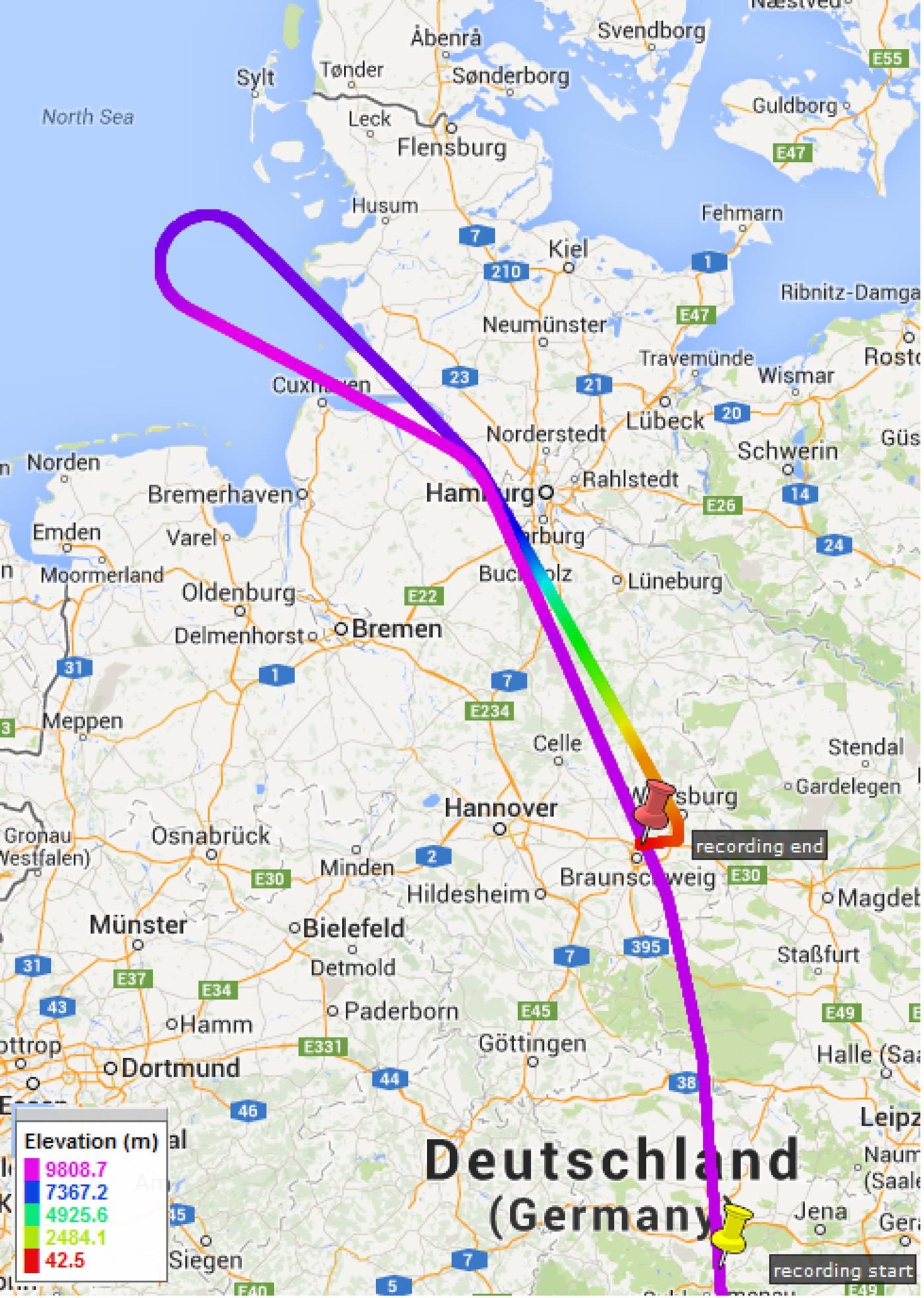
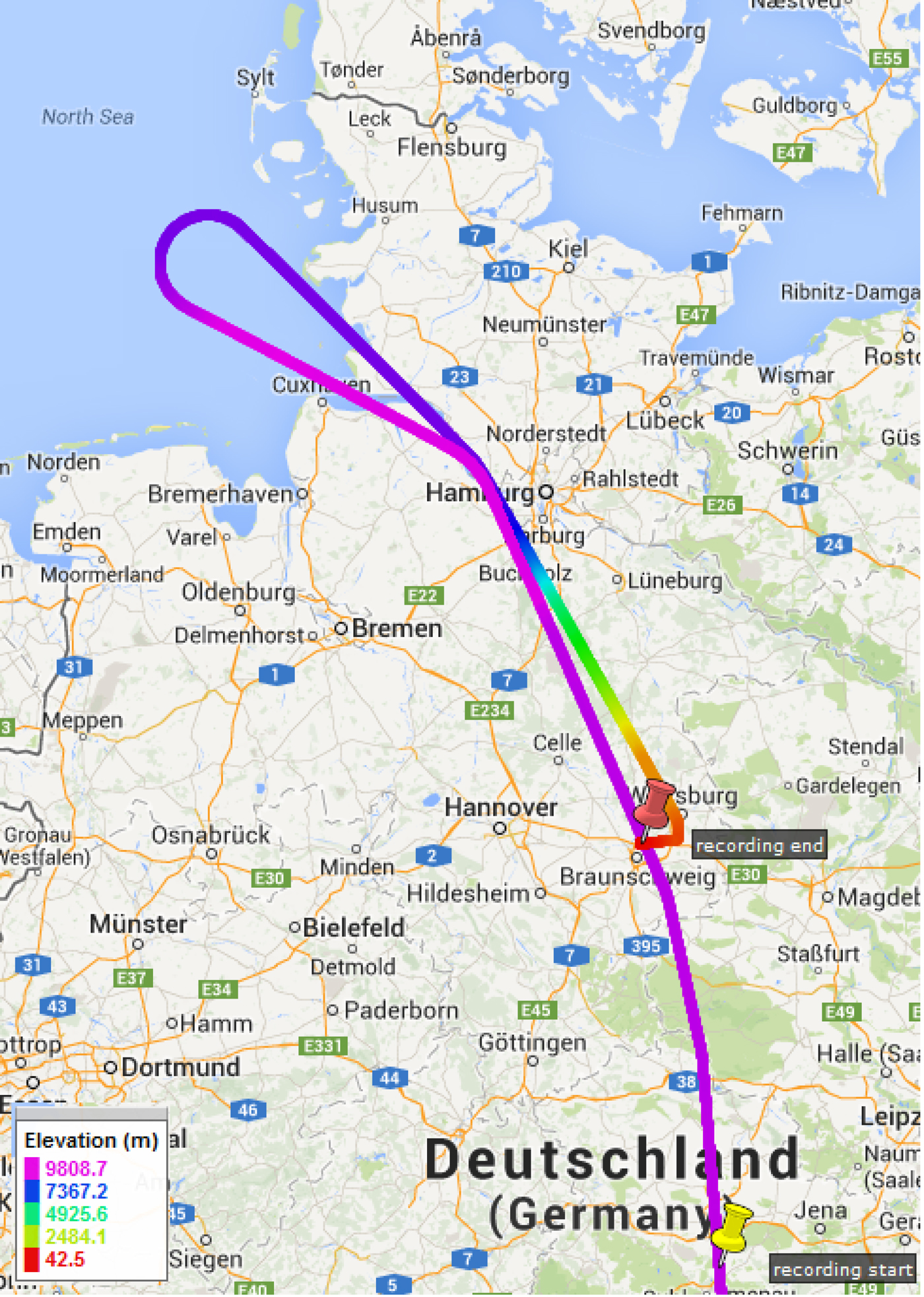
Figure 1 shows the flight path above Germany. The aircraft started in Southern Germany, passed near Hamburg, headed to the North Sea with turnaround above Helgoland, then went back over Germany and finally landed near Braunschweig/Brunswick. The altitude was between Flight Level (FL) 280 and FL 330 (8 500 m – 10 000 m). About 46 minutes of data were recorded before the approach for landing and are the focus of the analyses within this paper. Areas with low ship density in the interior of Germany were covered as well as high-density areas such as the ports of Hamburg and Bremerhaven, and the coastal regions of the North Sea.
Flight route with indicated different altitudes.
3. SYSTEM AND RECEIVER DESCRIPTION
AIS uses two VHF channels which are at 161·975 MHz and 162·025 MHz with a channel spacing of 25 kHz. AIS devices receive both channels at the same time and transmit on both channels alternately. To be independent of a base station that coordinates access to the channel, a SOTDMA scheme is used (ITU-R M.1371-4, 2010). The users within range organise themselves to use different time slots to avoid collisions. Every station builds up a slot map to keep track of slots that are used by other stations. Based on this scheme they select a free slot for their own transmissions. Each ship reports its position periodically for different vessels speeds. Gaussian Minimum-Shift Keying (GMSK) is used as modulation together with non-return-to-zero inverted (NRZI) encoding.
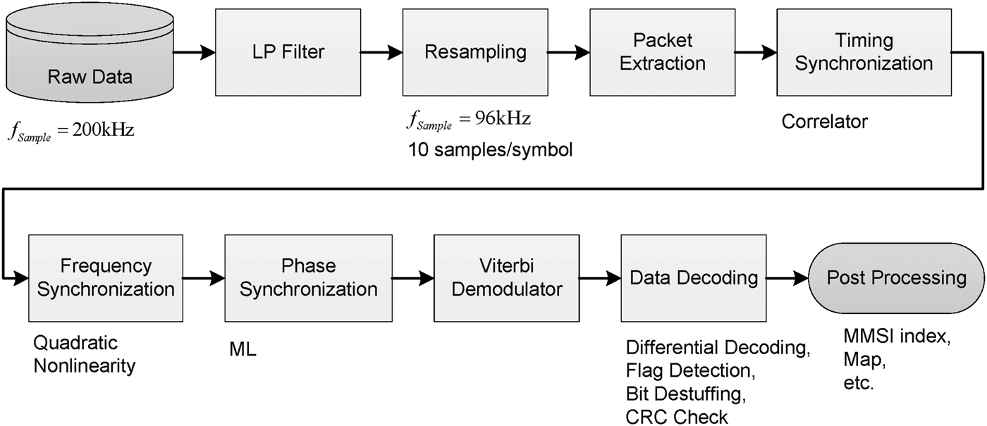
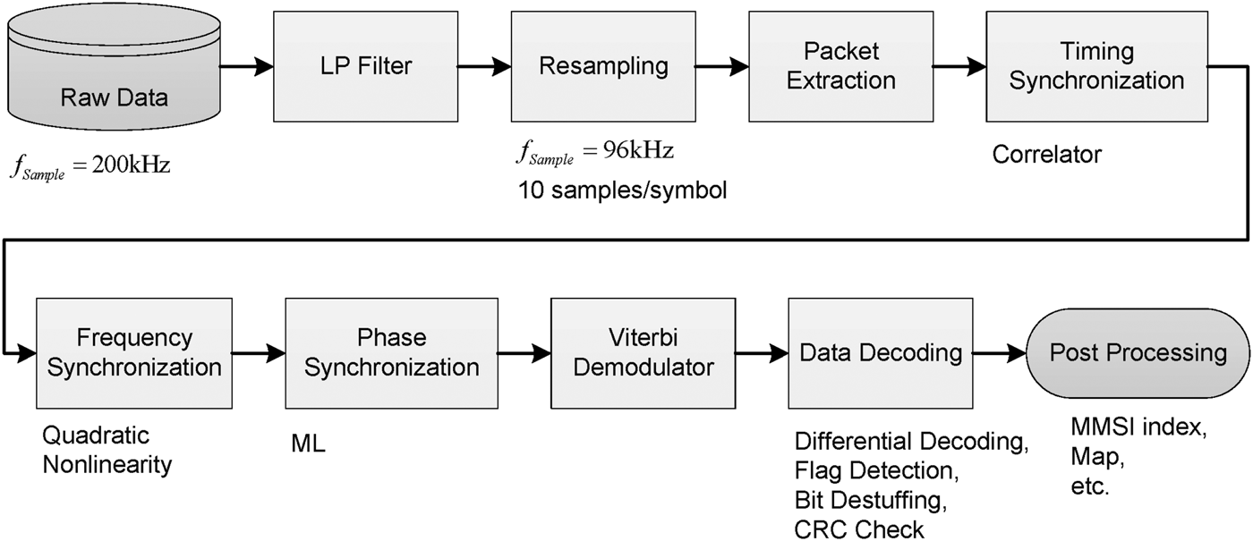
As shown in Figure 2, the receiver processes the raw data and extracts the AIS information. Both AIS channels were recorded simultaneously with a sampling frequency of 200 kHz. To begin with the channels are separated and the signal is then fed to a low-pass filter with cut-off frequency 10·6 kHz. The next step is resampling the signal in order to get an integer oversampling factor of ten, which results in a new sampling frequency of 96 kHz. The signal is then separated into packets exceeding a Signal-to-Noise Ratio (SNR) threshold of 0 dB. For each packet delay, carrier frequency offset, and phase offset are estimated and compensated. Therefore, the receiver features combined estimation of delay and frequency offset for timing synchronisation. Frequency synchronisation is improved by a second non data-aided estimation based on a Quadratic Non-Linearity (QNL) estimator (Morelli and Mengali, Reference Morelli and Mengali1998). The phase offset is also compensated using a non-data-aided approach described in Mengali and D'Andrea (Reference Mengali and D'Andrea1997). Next coherent Viterbi demodulation is performed (Anderson et al., Reference Anderson, Aulin and Sundberg1986). After differential decoding, the payload is extracted with the help of a High-level Data Link Control (HDLC) protocol (ISO, 1993). After performing bit de-stuffing, the payload is separated in a data and Cyclic Redundancy Check (CRC). Finally, if the checksum matches, the message data containing ship Identity (ID), position, etc. is stored into a database. More details of the implemented receiver can be found in Poehlmann (Reference Poehlmann2014) and Plass et al. (Reference Plass, Poehlmann, Dammann and Gentner2014).
Architecture of implemented software receiver.
In order to evaluate the true signal quality, a SNR estimator based on the Maximum-Likelihood (ML) estimation theory is implemented. In this way the Signal-to-Interference-plus-Noise Ratio (SINR) can be estimated. A data-aided approach is taken: The received preamble of each packet is compared to an undistorted reference preamble. In Pauluzzi and Beaulieu (Reference Pauluzzi and Beaulieu2000) this approach was found to fit for Additive White Gaussian Noise (AWGN) channels. Due to the existing line-of-sight between ship and aircraft this ML estimation method fits to aircraft AIS receivers under the assumption of perfect synchronisation.
For a typical aircraft speed of 840 km/h and a maximum ship speed of 48 knots the maximum Doppler (plane and ship moving in the opposite direction) is 139 Hz. It was verified that the frequency stability of the used receiver hardware is better than 30 Hz. Nevertheless, the data analyses showed a larger range of the received Doppler [−700 Hz, +700 Hz] at the aircraft. This confirms the results in Bouny et al. (Reference Bouny, LeMaitre and Millerioux2012) and the existing specification (ITU-R M.1371-4, 2010) requires the frequency stability of the transmitter to be better than 500 Hz. This range is apparently being covered by AIS transceivers on the market.
AIS transmitters available on the market do not only have a certain carrier frequency offset, which is compensated here, but they also generate phase noise. Another drawback is that transmitters often have a modulation index which differs from the given value 0·5 (Bouny et al., Reference Bouny, LeMaitre and Millerioux2012). The performance of the Viterbi demodulator is affected by that. For the original usage scenario of ship-to-ship communication the link margins are so high that simple non-coherent demodulation can be applied and these effects are negligible. However, this makes the design of an optimum AIS receiver for satellite or aircraft, which involves low SNR, quite challenging. One way to deal with that would be to estimate the modulation index and adapt the receiver accordingly. That part is not taken into account in the current receiver architecture.
4. ANALYSIS OF RECORDED DATA
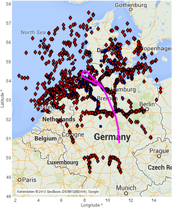
The whole length of the analysed data records is about 46 minutes. Figure 3 shows the flight path in purple together with ship positions from all AIS signals that have been received during that time. The red diamond markers represent the moving ships' final positions, the blue squares moored ships. Position reports received earlier are indicated with smaller red or blue markers. The large reception radius is evident. The aircraft flying over Germany could see ships near the Dutch coast as well as ships around Copenhagen. Several inland waterways are covered as well as parts of the North Sea and Baltic Sea. Areas with dense shipping traffic such as Hamburg and the river Elbe, Bremen, Bremerhaven, and Kiel are included, too.
All detected ships on flight route within 46 minute data records.

4.1. Packet Statistics and Message Types
The packet statistics in Table 1 reveal a high number of detected packets. The percentage of error-free packets is only 29%. This is a first indication that a lot of packet collisions have happened. With a total of almost 179 000 received packets, a good overview of the typical AIS communication traffic can be obtained. As indicated in Plass et al. (Reference Plass, Poehlmann, Dammann and Gentner2014), with about 78% by far most of the packets are normal scheduled position reports. The second biggest percentage of 16% is position reports that were sent in response to interrogations from other vessels.
Statistics of 46 min recorded data during measurement campaign.

4.2. Coverage Area
When obstructions and atmospheric effects are neglected, the aircraft coverage area is determined by assuming line-of-sight propagation conditions. The theoretical coverage area by an assumed aircraft altitude of 10 km and ship antenna height of 10 m has a radius of 368 km (Plass et al., Reference Plass, Poehlmann, Dammann and Gentner2014).
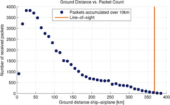
Since most of the packets received were position reports and the GPS position of the aircraft was tracked, the hypothetical coverage area can be compared to the actual one. For that, the ground distance between ships and the aircraft, projected on ground, has been calculated. We can see from Figure 4 that the theoretical radius is actually reached, but only a few packets were received at that distance. In fact, the packet count drops drastically with increasing distance. Reasons for that are packet collisions in combination with path loss. When a packet from nearby collides with one from far away, which is maybe 10–20 dB weaker, the first packet survives. It is worth noting that the number of detected packets also drops for low distances. This is caused by the antenna pattern, which tends to zero for the corresponding directions. Also for satellite AIS, the centre of the footprint has a low detection probability.
Number of AIS packets received with correct CRC from a certain distance.

4.3. Comparison with Terrestrial AIS Data
Within the work of Plass et al. (Reference Plass, Poehlmann, Dammann and Gentner2014) a limited preliminary terrestrial AIS test bed was used for comparison. This was deployed in the surroundings of Bremerhaven on the North Sea. We now show an evaluation of the detected aircraft AIS data with a full set of terrestrial AIS data provided by the German Federal Waterways and Shipping Administration over the whole country's territory. The data set used does not include inland waterways.
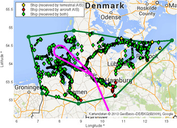
For comparison with the aircraft AIS, a time window of 32 minutes has been chosen in which the whole area is within the aircraft's reception radius. Figure 5 shows the area covered by the ground-based AIS receivers. The polygon was constructed taking into account the outer ships to define the reception radius of the terrestrial AIS. Within Figure 5 three types of detected ships are specified: Ships detected only by terrestrial AIS in yellow; ships detected only by aircraft AIS in red; and ships detected by both systems in green.
Comparison of terrestrial and aircraft detected AIS data.

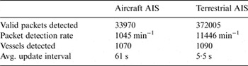
Looking at Table 2, we see that the terrestrial AIS has received about ten times more packets and detected only 20 more vessels out of about 1 000. All values are with regard to the defined area. The map in Figure 5 reveals that most ships were detected by both systems. There are, however, ships that were detected by only one of the systems. 41 ships were detected by aircraft exclusively due to the missing data of the inland waterways of the terrestrial data set. The aircraft on the other hand could also not detect all ships. 21 ships were only detected by the terrestrial AIS system in the outer coverage regions of the aircraft's footprint in the Eastern part of Germany's Baltic Sea. Consequently, the closer the ship is to the aircraft the higher the detection probability. The detection probability depends on the distance between ship and aircraft, see also Figure 4. Assuming the terrestrial AIS as reference the aircraft AIS would provide a packet detection probability of 15%. Even with the used simple receiver design without any multi-user interference cancellation, an averaged updated interval of 61 s can be achieved which gives a feasible tracking and surveillance rate.
Comparison of aircraft and terrestrial AIS.

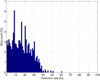
Figure 6 shows the distribution of detection rates versus the percentage of all ships. There are some individual ships with a detection rate of more than 35% but not more than 60%. Nevertheless, there is no significant distribution decrease or gain over the different detection rates.
Distribution of the detection rate versus ship count.

5. AIS AIRLINER INFRASTRUCTURE
In Plass and Hermenier (Reference Plass and Hermenier2014), the idea of using regular commercial aircraft in operations for a global monitoring of ships was introduced. Within this section a closer look is taken at the identified aircraft footprint of the previous section. A pessimistic assumption was made in Plass and Hermenier (Reference Plass and Hermenier2014) with regards to the area covered area by aircraft's footprint being around 200 km in diameter in an open sea scenario. This size of footprint could hold in mainland scenarios influenced by the terrain impact as shown in Plass et al. (Reference Plass, Berioli, Hermenier, Liva and Munari2013). Also the flight measurement campaign confirms the assumption of a footprint with radius between 170–180 km on the mainland due to the underlying terrain grade. Focusing on the starting point of the flight measurement campaign, Figure 2 shows detection of ships on inland waterways in the area of Nuremberg (north of Munich), approximately 170–180 km away from the aircraft's position. Nevertheless, ships are not detected in the area of Regensburg (out of range, more than 180 km) on the already navigable Danube (east of Nuremberg) in contrast to ships detected already on the North Sea close to Cuxhaven more than 300 km away.
The newly validated footprint radius of about 370 km directly raises the questions: How large is the overlap of both traffic systems now? And how often can a ship see an aircraft flying over it averaged over one day?
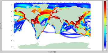
Figure 7 shows the simulated global coverage density at sea. Inland waterways, the Great Lakes, Caspian Sea, and the Black Sea, etc. are not considered here. The coverage intensity of each evaluated square area (1° by 1°) over 24 hours is represented as the number of contacts within this time period. Therefore 100% represents 120 contacts over the day due to a 12-min snapshot frequency. Yellowish and reddish colour represents more than 70 contacts per day with potential ships in these areas. Even light bluish coloured areas have more than 10 contacts per day. For comparison, a global coverage figure for the pessimistic footprint of 200 km diameter is given in the second figure of Plass and Hermenier (Reference Plass and Hermenier2014).
Airliners coverage on oceans of all commercial flights during 24 hours on 21 May 21, 2007 with an aircraft footprint of about 370 km radius. Colour represents the number of contacts per day with potential ships in these areas.

The problem for an evaluation of global coverage rates between ship and airline traffic is the non-existing global real time ship patterns. Global coverage could be given by satellite AIS. However, verification of successful AIS detection via satellite is not so easy to do (Brusch et al., Reference Brusch, Lehner, Fritz, Soccorsi, Soloviev and van Schie2011; Zhi, Reference Zhi, Kefeng, Xiangwei, Huanxin and Shilin2014). In Greidanus et al. (Reference Greidanus, Alvarez, Eriksen, Argentieri, Cokacar, Pesaresi, Falchetti, Nappo, Mazzarella and Alessandrini2013), a detection probability including satellite AIS and Long-Range Identification and Tracking (LRIT) were only 50% compared by radar survey. Within these evaluations, we take advantage of freely available global data from several global satellite AIS detection sets of ship patterns by the EU PASTA MARE Project (2010a). Also in these data, the satellite AIS system used could detect about 1/3 of the AIS equipped ships. Therefore the ship patterns were weighted by a factor reaching the total worldwide number of 60 000 assumed ships.
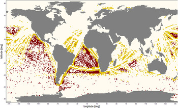
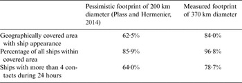
Geographically, the airliners globally cover 84% of areas with ship appearance (only 62·5% with the pessimistic footprint (Plass and Hermenier, Reference Plass and Hermenier2014)). In contrast to the geographical distribution, the overall AIS detection probability by airliners is now an astonishing 96·8% (only 85·9% with the pessimistic footprint (Plass and Hermenier, Reference Plass and Hermenier2014)). The likelihood of possible AIS detection by revisits of airliners is very high (at least once a day for this evaluation). Even 78·7% of the overflown areas have actually more than four contacts per day. These figures are summarised in Table 3. Also Figure 8 shows the difference of geographical detection coverage for the pessimistic and measured footprint. The yellow areas identify the additional coverage areas by having the measured 370 km radius footprint compared to the pessimistic 200 km radius. The brown areas denote areas not covered by airliners.
Additional airliners' coverage by having a footprint of about 370 km radius compared to 200 km coloured in yellow and non-covered shipping areas.

Airliner potential global coverage for AIS detection.

However satellite and airliner AIS are complementary as the regions not covered by the airliners are perfectly covered by satellite AIS.
6. DISCUSSION
AIS data are beneficial or even required in the following areas: vessel tracking / monitoring; traffic pattern monitoring; notice of arrival / pre-arrival notification; ship reporting; port state control; environmental protection; search and rescue; anti-piracy applications. Requirement for sufficient usage by major applications is a location update of at least every three hours (Cervera et al., Reference Cervera, Ginesi and Eckstein2011).
Studies show the need for 5–10 Low Earth Orbit (LEO) satellites at an altitude of 600 km to guarantee a target probability of ship detection of about 80–90% (Cervera et al., Reference Cervera, Ginesi and Eckstein2011; te Hennepe et al., Reference te Hennepe, Rinaldo, Ginesi, Tobehn, Wieser, Olsen, Helleren, Challamel and Storesund2010). Recently, the largest satellite AIS provider launched its fifth AIS satellite (exactEarth, 2013). The proposed concept of AIS detection airliner infrastructure could be used as a complementary system. Due to large airline alliances such as OneWorld or Star Alliance, global coverage with a high number of vessel contacts per day could be guaranteed - even a large airline (e.g., United Airlines, Lufthansa, or Air France) could cover large global areas with its own network with several ship contacts per day. Furthermore, as shown in the evaluation of the flight trials reported in this paper, the applied simple receiver design used here successfully detected all ships within its coverage area including a reasonable detection rate of 60 seconds on average. Beneficially, fewer overlapped AIS signals are within the smaller footprint of an aircraft. Furthermore, assuming the measured footprint of about 370 km, even the less frequent aircraft routes around the West African Coast and from the Cape of Good Hope to Asia are adequately covered, see Figure 8.
Finally, for a larger coverage and higher detection probability several integrative systems with different data sources are proposed or already exist. For example, overall situation awareness is increased by using detection data from AIS, Inmarsat and the Chinese BeiDou navigation satellite system (Yang, Reference Yang, Hu, Tu and Geng2012). Other multi-source approaches can be found in Greidanus et al. (Reference Greidanus, Alvarez, Eriksen, Argentieri, Cokacar, Pesaresi, Falchetti, Nappo, Mazzarella and Alessandrini2013) and Zhi (Reference Zhi, Kefeng, Xiangwei, Huanxin and Shilin2014). Additionally, all collected data could be fed into an Internet AIS (Filjar et al., Reference Filjar, Desic, Pokrajac and Cubic2005), providing global data to all users.
7. CONCLUSIONS
Within this paper a flight measurement campaign collecting AIS signals at higher altitudes was analysed. The fundamental idea is the usage of airliners gathering AIS data on a global scale. Although the described receiver architecture does not carry out interference mitigation, all ships were detected compared to terrestrial based AIS reception within the range of the aircraft's signal reception.
It has been shown that a line-of-sight model is a good approximation of the actual coverage area of an aircraft in terms of AIS reception which results in a coverage footprint of about 370 km radius. However, the detection probability depends on the distance between ship and aircraft. Terrestrial AIS features a higher position update rate, but is limited to coastal areas. The update rate of 60 seconds on average for aircraft AIS is still high enough for surveillance and allows tracking with reasonable accuracy.
In total, this work showed more than a 96% AIS detection probability by airliners and about 78% of the overflown areas have more than four contacts per day on a global scale. This is an increase of more than 10% compared to the theoretical pessimistic 200 km radius footprint assumption. AIS detection via airliners can close the gap of global ship monitoring between coastal and satellite systems in an easy to implement way on aircraft.
ACKNOWLEDGEMENTS
We would like to thank German Federal Waterways and Shipping Administration providing the terrestrial AIS data base.
FINANCIAL SUPPORT
The research leading to these results has been carried out under the framework of the project ‘R&D for the maritime safety and security and corresponding real time services’. The project started in January 2013 and is led by the Program Coordination Defence and Security Research within the German Aerospace Center (DLR).