Introduction
Greenland is one of the few colonies of a European state that through a referendum decided to become an integral and semi-autonomous part of its former ruler, in this case the Kingdom of Denmark. The act of 2009 gave Greenland the right to self rule. Greenland additionally secured the right to have a referendum to decide one day whether or not to leave the Kingdom of Denmark as an independent sovereign state. There has for many years been a desire for full independence, but in order for this to come about it was generally realised that full financial independence from Denmark would be necessary. The lively debate in Greenland at present indicates that now that independence has taken centre stage a discussion of the present political and future possible geopolitical position of Greenland might be of general interest.
This paper is an update of an earlier paper in this journal (Taagholt Reference Taagholt1982), which is now firmly outdated. We begin here with a brief history of Greenland in order to throw into perspective the profound changes and lively debate which now characterise Greenland society. Greenland appears to be at a turning point.
Beginnings
The Inuit immigration to Greenland took place in several waves; each wave being terminated by deteriorating conditions which caused successive hunting societies to collapse, only to be replaced by a new immigration from Canada as conditions improved.
There were three main waves of so-called Palaeo-eskimo cultures: the Independence culture which arrived about 4000 years ago, and the Saqqaq and the Dorset cultures. The latter seems to have died out around 900 AD, being replaced by the Neoeskimo Thule culture, which arrived about 1100 AD.
When the Scandinavian Norse settled in southern Greenland about 980 AD, they observed traces of an earlier Inuit culture and soon came into conflict with the Thule people who were arriving at this time and rapidly spreading over the whole country. Climatic deterioration during the Little Ice Age clearly favoured the hunting Thule people over the Nordic farmers. People of the Thule culture still occupy Greenland, although they have experienced considerable mixture with Europeans through the centuries. This mixture is least in East and North Greenland (Tunu and Avannaa), with consequences noted below. In spite of the harsh conditions, the hunting culture has survived through many centuries only to succumb to modern western influences since World War II. Small pockets of hunters still survive, often with the help of subsidies, but most hunting today is of a part-time or recreational nature. History seems to show that the huge coastline of Greenland, totalling several thousand kilometres can support a hunting society comprising no more than 10,000 to 15,000 persons (perhaps a quarter of the modern population). Hunter access to firearms and fast speedboats has had a detrimental effect on the fauna (Hansen Reference Hansen2002) and this number could probably not be sustained under present conditions.
The Danish colonisation
An increased demand in the 18th century for whale oil (train oil) brought the European whalers from the north Atlantic (Spitsbergen) towards Greenlandic waters, mainly the Labrador Sea and Baffin Bay. This increased contact between the Inuit and the Europeans brought hitherto unknown diseases to the Inuit, who lacked natural immunity and many succumbed. It also saw the first mixtures with European blood.
With the Danish/Norwegian missionary Hans Egede's arrival in Greenland in 1721 the Danish colonisation of west Greenland started. The Royal Greenland Trade Department, KGH (a monopoly), established trading stations, known as ‘colonies’, where blubber (rendered for train oil), seal, walrus and reindeer skins and walrus and narwhal ivory were traded for consumer goods such as rifles, ammunition, coffee, tea and sugar, as well as provisions which were needed during periods of bad hunting. With the introduction of Christianity fights and vendettas, a marked feature of pre-colonial life, effectively ended, as did the reported tradition for old, burdensome people to commit suicide.
Colonisation and Christianisation also started a new tendency which still continues today. People began to concentrate at the colonial centres, attracted by the church and opportunities to trade. Previously society was essentially based on the nomadic family unit which could easily move to new hunting sites when the hunting conditions deteriorated. The more centralised and static distribution of population lacked this ability and was thus less consistent with the hunting life. The church took the initiative to start schools and, surprisingly, around 1800, relatively more Greenlanders were able to read and write than people in Denmark. Nevertheless, the old colonial status of Greenland based on a hunting economy, ruled over by Danish functionaries, was little changed right up to World War II, but after this completely new forms of subsistence would have to be found. It has to be admitted that colonial Greenland was a subsistence society with considerable charitable input.
The polar Eskimos in the Thule district of North Greenland (Avanaa), maybe around 60 persons, met Europeans for the first time when visited by John Ross in 1818. Later came the whalers. A major event was when Robert Peary arrived in the district, giving the hunters access to modern facilities such as firearms. Peary argued strongly that the USA should take over Greenland, and during the negotiations between Denmark and USA in 1916–1917, concerning the Danish sale of the Virgin Islands, the USA claimed that the deal should also include Greenland. This was in accordance with the Monroe doctrine from 1823, which stated that the USA would not accept European intervention in the Americas. Denmark refused, arguing that, although Greenland is geographically part of North America, it is politically part of Europe. The USA became the first nation to acknowledge Danish sovereignty over the whole of Greenland.
Contrary to this, Norway, which had ruled Greenland from the 10th century became part of Denmark in 1397, now reasserted its claims and occupied part of East Greenland (Tunu) in 1931. This conflict was presented before the International Court in the Hague in 1933, which ultimately granted Denmark sovereignty over all of Greenland.
The population of northeast Greenland was always very sparse, and had only been contacted by white explorers once. In 1823 twelve Inuit were observed, representing a group of maybe a total of 200–300 people. However, these people ran away from the Europeans when startled by a gunshot and the group either perished or emigrated, so the coastline all the way from Ammassalik via Peary Land to Thule district, extending over several thousand kilometres, was subsequently uninhabited until establishment of a settlement in 1925, now known as Ittoqqottoormiit (Scoresbysund). Apart from a few weather stations and Danish military posts, most of it is still uninhabited and for the most part makes up the world's largest national park.
Political security
Hans Egede's missionary work started the Danish colonisation of Greenland. Even if this had not happened, Greenland would not have been isolated from the rest of the world. Whalers from several European countries frequently visited Greenland and after 1800 several foreign expeditions passed Greenland on their explorations of the far north. If Denmark had not been present, Canada (earlier a British dominion) or the USA (as recommended by Peary) would possibly have taken over control of their huge geographic neighbour with a tiny population, which spreads over a vast 2 million square kilometres land area.
The security conditions during colonial times were rather simple as Denmark up to World War II maintained a mercantile isolation policy, so that in practice Greenland and its population were protected from contact with the outside world. It was essentially a closed territory and Denmark, while running a trade monopoly, argued this was best for the people.
Due to technological developments and its geographical position, Greenland's situation during World War II became strategically important. In accordance with the Danish governor of Greenland (now isolated due to the occupation of Denmark itself by the Germans), the USA assumed the defence of Greenland and established several military bases and a number of important meteorological stations. Cryolite, unique to Greenland and important for aluminium production, was suddenly strategically important with the huge aluminium demand for aircraft production. The sale of cryolite to the USA and Canada financed Greenlandic society and even paid for Danish embassies in the free world such as UK, Australia, Canada and USA. The war meant an opening up of the Greenlandic society and the Greenlanders got access to goods from the USA. For instance, until the outbreak of war the traditional Inuit train oil lamp (usually made of soapstone) was still the only source of lighting, heating and cooking for the indigenous people but was now replaced by kerosene appliances and later still by bottle gas and electricity. Wartime also brought the first stirrings of consumerism as many new products appeared.
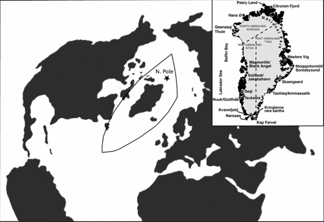
During the cold war Greenland, which lies between the two superpowers, was of supreme importance, as can only really be appreciated using maps with a polar projection (Fig. 1). For example, submarines from the former Soviet Union equipped with SS-N-8 SLMB missiles, which have a range of approximately 4,000 nautical miles, would be able to reach any target inside the NATO countries from any location inside the area shown around Greenland.
Greenland occupies a key position between Europe, north America and Asia as seen on a polar projection. Delineated: area of threat to NATO countries by submarines from the former Soviet Union (Bach and Taagholt, Reference Bach and Taagholt1982). Inset: place names mentioned in text.

From colony to self government
Conditions changed enormously during the World War period. Military personnel and materials entered the country introducing the population to new experiences. Some even worked on the bases and learnt English. But when the war ended Greenland was still a closed colony of Denmark. This could clearly not continue.
Developments during the war had resulted in an opening to the wider world and the population had a natural wish for access to all the technological achievements they had learnt of during the war. In 1953 the political status of Greenland was changed from a colony to an integral part of the kingdom of Denmark. By unanimous agreement between the Danish and Greenlandic politicians a massive development programme was established, which in just one generation changed society. Politically, Greenland was now set on a road to home rule in 1979 and further devolution in 2009, although Denmark still manages finances and about 30 additional fields of responsibility, among them foreign policy, defence, surveillance, search and rescue, the police and judicial system and several international obligations such as ICAO and WMO services. It should also be noted that the Greenland self rule is at present dependent on subsidies from Denmark (3,4 billion DKK/year) and other sources. This subsidy works out at about 62,000 DKK per person probably making Greenland the most subsidised nation on earth.
‘Hjemmestyre’ (or Home-Rule) of 1979 gave the Greenland Government responsibility in the fields of education (including technical education), social services, labour, radio, the library and other cultural services and from 1981, planning, museum and conservation matters, lawmaking regarding commercial fishery, hunting and trapping based on a yearly transfer of a block grant at about 3,400 million DKK.
The ‘Selvstyre’ (or Self-Rule) bill of 2009 allowed the government to take over further fields of responsibility (for example police and the judiciary) although no specific timing was set due to the complicated nature of the hand-over. Ulitimately Greenland would have to cover all its own expenses. Additionally there was provision for Greenland to leave the Kingdom of Denmark to become its own sovereign state.
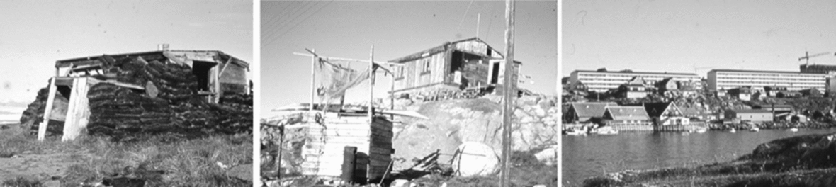
With Denmark's membership of the EU in 1973, Greenland was also incorporated in spite of a massive opposition to the idea in Greenland. When Greenland gained home rule in 1979, a referendum was held in which 52% voted to leave the union, primarily on the basis of the fisheries and this became a reality in 1985 with Greenland having OLT status within the EU. Nevertheless, this is a road which seems to lead to the ultimate establishment of an independent nation (Fig. 2). Note that Greenland is, until now, the only country to exit the EU.
The progression from turf huts via primitive wooden houses to modern concrete apartment blocks (photo: Taagholt)
Today, the primary occupation is fishery, which was founded on an abundance of cod during the warming period of the 30s, when seals, the traditional target of the hunters, decreased in number. Subsequently, a massive decline in cod about 1980 meant that the fishery today is mainly based upon shrimps and Greenland halibut. The lonely dinghy or small fishing boat is today disappearing in favour of large expensive trawlers equipped with fish processing and freezer facilities, producing products ready for export. Indeed, these ships may normally not access habours in Greenland. The green movement has led to a collapse in the price of sealskins and thousands of such skins, bought at subsidised prices, are now stockpiled and have proved impossible to sell, although a possible buyer might be China. At the time of writing this is still a serious problem. Conservationists (the most famous being Brigitte Bardot) claimed that seal populations were threatened and denounced sealing as inhumane. This might have been true of industrialised sealing, conducted by countries such as Norway and Canada, but is certainly not true for traditional Inuit hunters who lived by seal hunting, taking comparatively small numbers of animals. The domestic artisan industry producing tourist souvenirs based upon bone or ivory from narwhal, sperm whale or other the arctic animals was similarly hit by UN export restrictions as a conservation measure. Native artisans use such materials largely for tourist souvenirs and volumes used are low.
Accordingly there exists a high demand for new activities to boost Greenland's economy. At present, the tourist industry is the second largest earner but is largely in the hands of outside interests. Although several mines have operated in the past, none is at present open.
Demographic changes are also important. At present, the population decreases by a few hundred each year, largely due to emigration of the young for education and as job-seekers. At the same time the proportion of old people is rising, as is public expenditure. Greenland's leaders are surprisingly optimistic that any financial shortfall can be met by mineral exploitation and legislation has been introduced to facilitate both exploration and exploitation of minerals and hydrocarbons. Is this realistic?
Greenland's minerals
For some years the only mining activity in Greenland was the gold mine at Nalunaq [Greenlandic meaning: ‘place that is hard to find’] and the extraction of olivine at Seqi, but these operations closed in 2013 and 2010 respectively. No mining takes place in the country at present. However, the Aappaluttoq ruby and sapphire mine is reported to be about to open at the time of writing (July 2015) as is the exploitation of anorthosite for use in glass fibre production by the Canadian firm of Hudson Resources Limited.
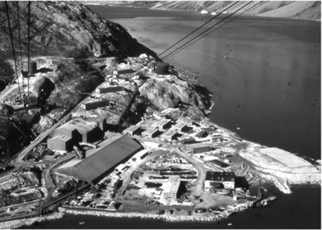
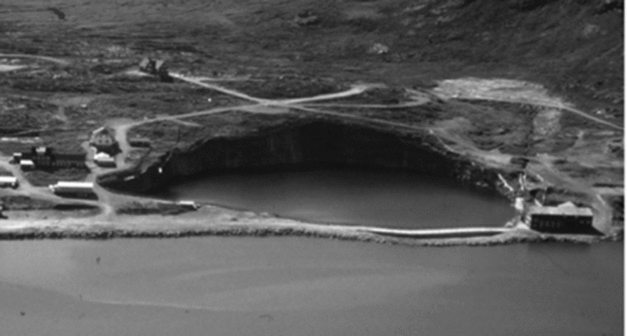
One of the last successful mines was the Black Angel Mine for zinc, lead and silver at Maamorilik (Fig. 3). This gave the Greenland society throughout the period 1972–1989 an average of about DKK 55 million per year. Such a figure has to be seen in relation to the yearly financial support from Denmark which amounts to around DKK 3,400 million per year, as noted above: the block grant. Many large mines will therefore be required to form an economic basis for the country should the Danish contribution be terminated. At the same time, the sensitive arctic environment must be protected and measures taken to protect the fishing industry.
The Black Angel Mine: former mining facilities at Maarmorilik (now largely demolished and the area landscaped). The cables in the foreground extend up to the mine portal at about 700m on a cliff face. (photo: Taagholt)
There are high expectations for the discovery and commercial exploitation of minerals, including oil and natural gas. Politicians speak about income from new activities such as an iron mine at Isukasia in the fjord complex of Nuuk/Godthaab, aluminium production based upon hydroelectric power, mining of rare earth elements and uranium from two locations near Narssaq, molybdenum from Mesters Vig, East Greenland and zinc from northeast Greenland.
Greenland has deposits of many important minerals, and global warming, with a consequent extension of the shipping season, promises easier access to such deposits. A major advantage is that the Greenland Geological Survey (now the Geological Survey of Denmark and Greenland or GEUS) has mapped Greenland geology for many years. Consequently, the geological outlines of the country are now well documented, although specific economic surveys are not well developed. A recent suggestion for the establishment of a survey organisation in Greenland seems to be an unnecessary expense (Kirkegaard and Kielsen Reference Kirkegaard and Kielsen2014). This was thought important due to the remoteness of Greenland, but in view of the speed of present-day communications it is a poor argument. Even in the late 1980s, Platinova's operations at Skaergaard in East Greenland (Tunu) could rely on the return of assay results from Toronto within a week.
Although the sparse vegetation makes it easier to find and evaluate mineral deposits, the cost of establishing a mine in Greenland is very high due to the harsh climate and lack of infrastructure. Thus, it requires much capital expenditure for works such as harbours, roads, power supply, housing etc. Additionally there is a lack of local workers and salaries for any local workers employed are as high as in Denmark, or much higher than in Asia or Africa. Recently the prices of raw materials have decreased due to the global financial crisis and the availability of cheap shale gas in the USA, causing 25 to 40% drop in oil prices. Consequently, no further oil investigations will be conducted during 2015, due to extremely high cost of Arctic off-shore drilling combined with low prices and environmental concern.
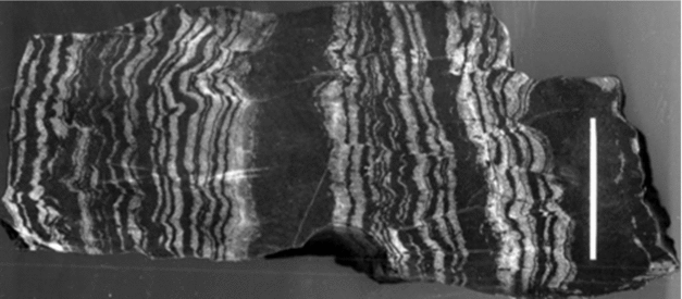
The Danish cryolite company, Øresund A/S, had for many years investigated the feasibility of exploiting the iron deposit at Isukasia, inland from Nuuk, but the company concluded that mining could not be established on an economically justifiable basis (Fig. 4). During recent years the company London Mining has held a concession on the deposit and have made plans for the establishment of mining facilities. However, London Mining is now insolvent and the concession has been taken over by a large Chinese mining company: General Nice Development Limited. Possible construction work might involve around 3000 workers, not available in Greenland, but imported from China. These developments have been highly controversial, from both social and strategic viewpoints. It is not clear whether China wishes to exploit the concession or just wants to exclude other companies. Nevertheless, it is clear that China has increasing interests in the Arctic in general, and Chinese industries have an insatiable need for raw materials. Even in the light of the current economic crash, China's long term interest in the Arctic is likely to sustain the quest for Arctic resources. For China it might be of interest just to have a presence in the Arctic, thus gaining desired Chinese influence in Arctic matters. For example, China has status as an observer on the Arctic Council and has built a large embassy in Reykjavik as well as a research station in Svalbard. At the university in Shanghai, China has established an institute for polar studies, arguing that resources in the Arctic regions, like those in Antarctica, ought to belong to all of mankind and not just to the five Arctic nations. This would seriously upset the Arctic nations. Moreover, the protocol in Antarctica forbids exploitation of natural resources. There has been a widely expressed concern that China's interest in Greenland's resources reflects a desire to gain strategic control of the area. However, many of the companies involved are private Chinese companies and Boersma and Foley (Reference Boersma and Foley2014), in a careful analyses of the situation, reject this, arguing that Chinese companies are simply trying to ensure supplies of raw materials for their huge demand.
Sample of the ore from Isukasia. This is a banded ironstone from the earliest Precambrian, consisting of magnetite-rich bands alternating with quartz-rich bands. The origin of such banding has generated lively debate. Banded ironstones are the world's largest iron ore deposits. Scale is 5 cm. (photo: Brooks)
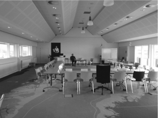
China, Japan and Korea, all showing interest in Arctic resources, were together with EU (the European Union) sceptical towards the former Danish Minister of Foreign Affairs, Per Stig Møller's initiative in 2008 at Jakobshavn/Ilulissat. Here, the five Arctic nations agreed upon the 2008 Ilulissat Declaration (Fig. 5), stating that problems or conflicts related to the high Arctic area should be solved only by diplomatic negotiations among the Arctic nations. The dissenting nations argued for an international control to be established similar to that of the Antarctic.
The conference hall at Hotel Arctic, Ilulissat, scene of the Ilulissat Declaration on future administration of the Arctic. Note that the carpet is a huge map of Greenland, possibly the largest, in existence. (photo: Taagholt)
Two commodities which are of special interest are uranium and rare earths. High-technology products such as mobile phones, magnets for wind turbines, etc. have led to a major and increasing demand for the rare earth elements. In recent years China has gained a virtual monopoly on the production and processing of rare earths (~97%) and it is feared that this will be used as an economic weapon as, it is suspected, has already happened with respect to Japan.
Greenland is generally thought to be well endowed with rare earth deposits (estimated to be 7 to 10% of known world supplies), which are viewed as a possible means to circumvent the Chinese monopoly threat. In particular, the EU has hoped to secure its own sources of raw materials and has signed an agreement to help Greenland develop its mining industry. However, there are two problems with this. Firstly China has the only know-how on processing rare earth elements, this having been abandoned by the west some years ago when rare earths were not of major interest. Thus any production from Greenland would have to be processed in China. The USA is attempting to resurrect its rare earth mining, but it is thought that about 15 years will be necessary to approach Chinese expertise in processing the ores. Thus, even non-Chinese deposits would still be effectively controlled by China.
The other problem comes from the fact that many rare earth deposits are associated with uranium (and thorium), which becomes an unavoidable by-product. Radioactive elements are subject to strict international regulations and there has been a controversy as to whether the Greenland or the Danish government should have the last say on this matter. However, the Greenland government has now relaxed the ban on mining of radioactive metals; deciding by a slim margin of 15 to 14 votes. The possibility of Greenland unilaterally exporting uranium ore (‘yellow cake’) has caused alarm in Denmark, which gave up its nuclear programme in the 70s.
In Greenland one observes an increasing concern related to possible environmental influence of future mining activity and especially popular opposition against extraction of uranium (although, as noted above this has now been defeated by a very slim margin). As uranium generally occurs associated with rare earths (the Kringlerne deposit in south Greenland is an exception) the mining of rare earths is problematic. Likewise, the Edinburgh company Cairn Energy experienced opposition from groups such as Greenpeace over drilling offshore west Greenland. There are therefore not only environmental but also technical and political problems including those against the export of uranium, which is under strong international restrictions.
There has recently been disquiet in Greenland about the way mineral resources are administered. Many see it as being in the hands of a small clique, which is unwilling to engage in public consultation (Nuttall Reference Nuttall2012). A case in point was the Isukasia project where local people felt brushed aside and there were public protests. Mining companies have a tendency to see Greenland as frontier territory and areas without settlement as undeveloped wasteland, although local people may enjoy a rich harvest from the area. The area of the Isukasia mine was described by an outside consultancy on the basis of short-term studies as ‘virgin territory’ and as it was uninhabited, development would lack social impact. It was also said to be an area of low biodiversity. In truth, local people value the area for its fishing, hunting (particularly caribou), berry harvesting and recreational resources.
The debate on Greenland's independence
The former president of Greenland Aleqa Hammond stated in 2014 that Greenland would leave the Kingdom of Denmark in her lifetime based upon the development of a rich mining industry in Greenland (Boersma and Foley Reference Boersma and Foley2014; Showstack Reference Showstack2014). This statement caused concern not only in Greenland and Denmark but also internationally. Economic independence would require some 20 new large scale mining projects to give enough yields to finance Greenland society and most experts would agree that the statement is extremely optimistic, indeed unrealistic. Hammond's aim of opening of three to five mines in the period to 2018 and two large oil fields within an interval of five years is regarded very unlikely by most experts, but an ambitious plan for the development of mineral resources has been set out, including the establishment of a Nuuk-based Greenland Geological Survey, which would presumably take over the tasks at present carried out by the Geological Survey of Denmark and Greenland (GEUS), which is located in Copenhagen. It was estimated that an income of over DKK 30 billion could be expected over a period of fifteen years from minerals and DKK 435 billion over 40 years from oil and gas (Kirkegaard and Kielsen Reference Kirkegaard and Kielsen2014).
Should Greenland be successful in finding a large source of mineral wealth, be it oil and gas or other commodities, viable independence would become a possibility. However, it would also increase the attraction for other nations to gain control of the country. In a situation in which the great powers like China are pushing forward and trying to have Arctic activities dependent on Chinese capital, and in which Russia shows increased ambitions in the Arctic, launching new nuclear submarines and planting the Russian flag on the sea floor of the Arctic Ocean, a military grab of the 4 million square kilometres sized Greenland area becomes increasingly less easy to rule out.
It is of course a natural wish for a former colony to be totally independent as a sovereign nation, and Aleqa Hammond's aim corresponds to this general feeling. But many in Greenland see problems such as decreasing living standards, increased burden of debt and limited work-force and recognise the difficulty of solving all the new responsibilities. Accordingly there is a need for objective information about not only the political and economical but also the geopolitical consequences of a referendum when the Greenlanders have to decide whether to embrace total independence as a sovereign state.
In Denmark and Greenland no strong debate has been seen about how other nations might react to Greenland as a weak independent sovereign state. An independent Greenland will find it difficult to meet international demands, including UN agreements. Maybe the USA with reference to the Monroe Doctrine of 1823 cannot accept the risk that other foreign nations take over the control of Greenland, if not with military force, but by economic superiority. At the least we would expect the USA to play an increasingly prominent role and Canada would certainly not sit on the side-lines.
From economic dependence on Denmark (and EU), Greenland could become dependent on China if large scale mining is based upon Chinese capital and includes many Chinese workers. However foreign capital is needed to assure the utilisation of Greenland's raw materials, so it is important for Greenland to establish a stable political development so investors from Europe as well as other counties from the western world have confidence in the country. Of possible relevance here was Greenland's withdrawal from the EU in 1985.
The present economic situation
As alreadt noted, the Greenland economy is strongly dependent on transfer from outside (Denmark and EU): at present amounting to a total of about DKK 4.7 billion or about 35 % of the national gross product. Since 2012 the economic situation in Greenland has been declining, with a yearly deficit expected to grow from DKK 90 million towards perhaps 1000 million during the coming years. The total population is slowly declining, the relative proportion of elderly is increasing, unemployment is high, and the education level needs much improvement.
Immigration of unskilled workers, at the time of devolution regarded as a thing of the past, has continued during recent years, although Greenland has a relatively high unemployment.
The fishing industry is mainly based upon shrimps, although the catch has decreased due to climatic changes. Cod numbers (the most important fish) increased during the period 1930–1980, until climate cooling diminished the catch. This has now improved but the growing number of cod threatens the shrimp fishery as shrimp larva are the most important item in the cod's diet. The catch of Greenland halibut has shown minor growth. There is a need for improved processing of the fish to take better advantage of the living fish resources but it seems unlikely that income from fishing can be significantly expanded.
The global financial crisis has led to a reduction in mineral exploration and at present no mining activity occurs after the recent closure of the Nalunaq gold mine in 2013. The number of tourist and tourist cruises has also been decreasing for the same reason, but may be expected to rebound in the coming years.
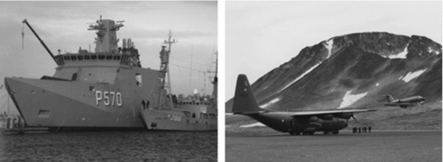
The Greenland self government's economy today has a relative large deficit, although it receives the previously named subsidies each year. In addition to this contribution Denmark still performs about 30 different fields of responsibilities as noted above. Not only the operational cost but also a demand for investment in material such as inspection ships, aircraft, etc. seems not to be a practicable burden for a possible independent Greenlandic nation. In addition Greenland does not have the needed manpower with specialised education to conduct specialised tasks. Even the military dog sledge patrol, Sirius, which covers the huge area from Scoresbysund via Peary Land to the Thule district has attracted only a very few Greenlandic volunteers. An independent Greenland might leave the huge sea around Greenland as a military gap (Fig. 6).
Danish inspection vehicles operation in Greenland. (from Steenfos and Taagholt Reference Steenfos and Taagholt2012)
If one compares Greenlandic society, counting about 57,000 inhabitants spread over 2 million square kilometres, with a typical Danish municipality having the same number of inhabitants, such a Danish location, although geographically tiny, would not be viable if it needed more than 20 schools, 3 high schools, 2 universities, 3 district hospitals, 13 airports, 10 ports etc., as do the people of Greenland due to their geographical distribution.
Mineral resources combined with potential hydroelectric power are expected to play an important role locally as well as internationally. Locally the wish is to establish an independent self-sustaining, multi-pronged economy not solely based on fishing. Internationally the economy would be sustained by the large deposits of iron as well as alloy materials such as chromium, molybdenum and nickel which are needed for advanced steel production. In addition, exploitation of deposits of more costly metals such as silver gold, platinum and palladium is envisaged. According to some Greenlandic politicians the potential offshore deposits of oil and gas, could make Greenland as rich as some of the middle-eastern states. The recent decrease in oil prices, the increased ecological and environmental concern and the high cost related to the exploitation of Arctic oil, have toned down these expectations. Nevertheless, the presently depressed hydrocarbon prices are generally expected to rise again in the not-too-distant future and the concerns of environmentalists will doubtless be overcome should offshore oil and gas fields be discovered.
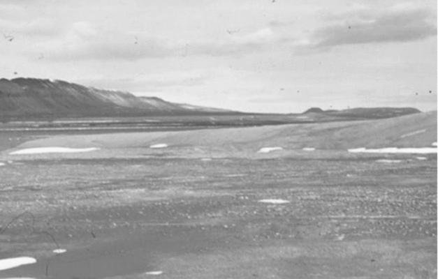
At present, evaluation is continuing for the iron mine at Isukasia, near Nuuk/Godthaab, mining of rare earth minerals (and uranium) at Narsaq (Kvanefjeld and Kringlerne deposits), zinc from Citronen Fjord, Peary Land (Fig. 7), aluminium production based upon hydroelectric power near Maniitsoq/Sukkertoppen and gold and platinum group metals at Skærgaard, East Greenland (Tunu).
Peary Land, which hosts the Citronen Fjord zinc deposit, a polar desert, with a very cold, very dry climate and nearly 5 months continual winter darkness (photo: Taagholt)
Several of the projects are based upon capital from China. However, the value of such resources has generally decreased during recent years owing to the worldwide economic crisis.
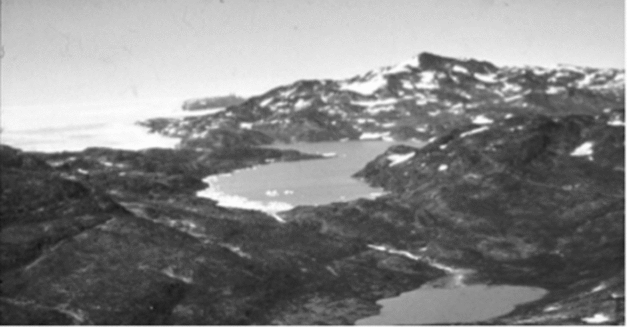
Melting from the inland ice gives a significant potential for hydroelectric power (Fig. 8) and in 1993, Greenland's first hydroelectric plant, 45 megawatts, went into operation. In recent years several hydroelectric plants have been established. Also, investigations have been carried out to find further industrial uses for the potentially massive hydroelectric resources of Greenland. Locating power-hungry industries for such products as aluminium or synthetic fertilizer in Greenland are under consideration and studies have been made of the possibilities of exporting electric current via cables carrying high-voltage direct current and exporting energy in the form of liquefied hydrogen.
Nordbosø in Johan Dahl land 25 km north of Narsarsuaq, 600 m over sea level, might form the basis for a production of energy totalling some 225 million kilowatt-hours per annum. Greenland has many such locations along the border of the ice sheet. (photo: Taagholt)
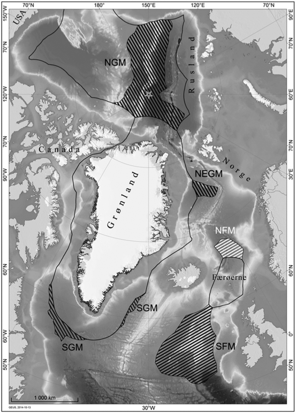
Areas claimed by the Kingdom of Denmark and Greenland submitted to the UN Convention on the Law of the Sea (shaded areas). The black lines show the limit of the exclusive economic zones of the adjacent states and areas in dispute are shown with diagonal shading. While the area north of Greenland is by far the largest area, other claims are shown (Anon. 2014; Marcussen and others Reference Marcussen, Mørk and Funck2015).
Reconciliation
The former president of Greenland Aleqa Hammond has established a reconciliation committee (reported by Reuters, 2 May 2014 and Torkild Kjærgaard at the University of Greenland in Godthaab/Nuuk, reported in Politiken (Copenhagen) 12 January 2014, ‘Greenland commission will probe Danish colonial abuses’) raising some debate both in Denmark but mainly in Greenland. Such a reconciliation committee is based on the well-known Truth and Reconciliation Committee based in Cape Town, which was designed to heal the divisions caused by the injustices of apartheid in South Africa.
Of course Denmark has made several errors in the colonial administration of Greenland, but while many other European countries have exploited their colonies, Denmark has not. During the past 300 years the Greenlander has been treated as a countryman, so the Dane has nothing to reconcile, nothing to regret. On the contrary Greenland is the only positive exception in relation the rest of the world. The Greenlander Finn Lynge stated: ‘Greenland has their descendent roots among the Inuit in Alaska and Canada but their family in Denmark’. Looking in the literature one finds statements from, for example, foreign explorers passing Greenland such as Sir George Nares, who wrote (Nares Reference Nares1878): ‘Since 1721, the year of Hans Egede's settlement at Godthaab in South Greenland, the Danes have consistently endeavoured to improve and ameliorate the condition of the Eskimo inhabitants of Greenland. Their efforts have been crowned with marked success’.
Maybe there is indeed a need for reconciliation in Greenland, but this would be an internal reconciliation. Danish speaking Greenlanders or even Greenlandic speaking Greenlanders with lighter skin and lack of Inuit characteristics, are frequently told that they are not really Greenlanders. Many young Greenlanders returning to Greenland after years of education at universities abroad are received home with some hostility: they are not regarded as ‘real’ Greenlanders because of their long absence from Greenlandic society. Some of them leave again in frustration, even though they are very much needed in Greenland. It is a threat to Greenlandic society that so many well qualified and well educated Greenlanders elect to leave their homeland. Emigration during the past 15 years amounts to about 10,000 persons (one-fifth of the total population). Another group of Greenlanders who feel discriminated against are those from the east coast (Tunu). They have always had a lower living standard than their west coast brothers, largely due to the greater logistic difficulties. Their dialect differs markedly from that of the west coast (Kitaa) and they commonly report being treated with scorn and derision and even discriminated against in the job market by west Greenlanders, who regard them as backward and strange in their behaviour. For further school education the children in Qaanaaq in North Greenland (Avannaa) have to go to West Greenland (Kitaa) for high school, but many leave the school and return to Qaanaaq complaining of bullying and spend their time playing ball games, because they do not want to be hunters. It seems that much of the unkindness to Greenlanders is the result of other Greenlanders behaviour. As noted above, Greenlanders also feel patronised by the authorities responsible for mining development. It thus seems that much of the intolerance experienced by Greenlanders is the result of other Greenlanders behaviour.
Today more than 85% of the population lives in towns, one-third lives in the capital Godthaab/Nuuk. Most of the population have Danish family relations, but about half of the population do not speak Danish fluently, although Danish is still the dominant administrative language. This of course leads to language problems. If Greenland one day becomes an independent nation all agree that a better education level is needed. Higher education at university level can only in be conducted in Danish or other foreign languages, so improved language skills are a priority.
Greenland's geopolitical position
Until World War II, Greenland was a very distant, isolated place attracting little international attention except for the frenzied searches for the northwest and northeast passages in the 18th and 19th centuries. During World War II Greenland suddenly gained a strategically important status and this continued unabated throughout the years of the cold war. Today there is a growing international interest in the Arctic fuelled by the endless search for resources and by global warming and climate change with the opening of the elusive northern sea routes and easier access to the Arctic resources.
The use of the northern sea route from the Bering Strait north of Siberia to the north Atlantic (traditionally known as the northeast passage) has increased during the past years. During 2012, 46 commercial ships passed this way, the number growing to 71 ships during 2013 including the first commercial container ship coming from China. It can be expected that, with global warming, the northwest passage through the Canadian archipelago will become open for regular navigation for part of the year. In October 2013, the Danish bulk carrier Nordic Orion completed the first-ever commercial transit of the northwest passage, although this was not repeated in 2014. If the passage does indeed become an international route, this will doubtless have sovereignty implications for Canada and increased traffic, mainly for cargo but also by tourist ships. Likewise, Greenlandic waters will require reinforced surveillance and search and rescue services. The prospect of increased activity in northern waters explains the efforts now being made to resolve territorial disputes as exemplified by the question of Hans Ø/Island in the Kennedy Canal [Dawes Reference Dawes1985; Politiken (Copenhagen) 29 November 2012; The Globe and Mail (Toronto) 29 November 2012].
Such developments increase the value of Greenlandic resources and open new possibilities for Arctic tourism, but additionally demand increased services related to weather- and ice-forecasting, inspections and environmental control, search and rescue and, to assure sovereignty, additional military power.
After the Danish ratification of the UN Convention on the Law of the Sea in December 2004, a Danish continental shelf project has been conducted for seismic and bathymetric data acquisition necessary for the documentation of the extended continental shelf in the high Arctic (Anon. 2014). The work was conducted using chartered vessels (mainly the Swedish ice-breaker Odin for three seasons, but also a Russian nuclear ice-breaker on one occasion) as Denmark does not have ships able to operate in the central Arctic Ocean.
The most recent Danish partial submission for the northern continental shelf of Greenland was presented in December 2014 to the Commission on the Limits of the Continental Shelf, where rights to the sea floor outside the 200 nautical miles economic zones will be apportioned.
The Danish claims for the right to the sea floor include two areas off the Faroe Islands, two areas off south Greenland, an area northeast of Greenland and the huge area across the polar sea from Greenland which includes the North Pole. However, in August 2015 Russia, not unexpectedly, presented overlapping claims for this last area (Laursen Reference Laursen2015). Britain and Ireland will certainly challenge the southernmost area. It may take 20–30 years before the final agreement is obtained.
A possible future independent Greenlandic nation would be unlikely to have sufficient manpower to manage all the daily duties, to maintain international requirements according to UN regulations and to fulfil all the diplomatic negotiations both with other countries and international organisations. It would thus be disadvantaged in important international discussions.
The present Greenlandic debate
The former president of Greenland, Kuupik Kleist, together with the geologist Professor Minik Rosing proposed in Politiken (Copenhagen 20 November 2012) that a working group of Danish and Greenlandic experts in industrial development, administration, business law and socio-economic conditions should evaluate the problematic status for the future of Greenland.
Accordingly, the question about economic independence was analysed in the report ‘To the benefit of Greenland’ published in the spring 2014 by the ‘Udvalg for samfundsgavnlig udnyttelse af Grønlands Naturressourcer’ [The Committee for Greenlandic mineral resources for the benefit of society] by Ilisimatursafik/University at Nuuk and the University of Copenhagen (Rosing and others Reference Rosing, Mosbech and Mortensen2014). The report concludes that utilisation of raw materials is important for Greenland's development, although it is seen as unrealistic that such activity can give sufficient yield for the Greenland economy to be wholly independent of economic support from Denmark. Additionally the report suggests that yields from the mining industry should be placed in a sovereign wealth fund and only the yearly yield from this fund be used in the annual Greenland budget. A worked-out mine is just that: a valueless empty hole in the ground (Fig. 10), while fishing may be sustainable for the indefinite future, continuing to yield money to be used in daily social life. Accordingly such money may count 20 times as much as money from mining, where only the yields from the trust ought to be used.
The exhausted mine at Ivittuut as it looks today after export of 3,700,000 tons cryolite and flooding by the sea. (photo: Taagholt)
This important report has formed the basis for a more realistic and less confrontational debate on the relations between Denmark and Greenland. Some Greenlandic politicians have stated that the question of independence is not especially relevant. Greenlanders want to be able to choose between dependency on Europe, the USA, and possibly Canada or on a continued cooperation with Denmark.
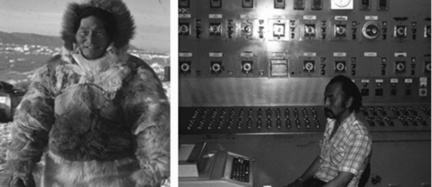
The rapid change from a hunting to an industrial society in just one generation has caused many problems. It is easy to understand that for an eminent hunter a job as technician, bus driver or worker at the fish factory seems daunting. But the Greenlander has adapted to modern technology to a high degree and technology today is an important part of the Greenlandic culture. For the new generation with increasing higher education (although too few at present) acceptance of massive change in society (Fig. 11) gives hope for the future and understanding of the problems related to the geopolitical situation.
Greenlanders today: the highly respected Arctic hunter and the well educated industrial worker. (photo: Taagholt)
Oddly enough, in spite of their hugely contrasting sizes (Scotland: 78,772 km2 Greenland: just over 2 million km2: the ice-free land in Greenland is approximately five times the area of Scotland, which is about 79,000km2) and populations (Scotland: 5.2 millions, Greenland: just over 56,000) there are many parallels to the Scottish independence question. Not least, this involves the question of natural resources and perceived grievances. In both cases the protagonists for independence claim vast natural resources which will fuel a vibrant and independent society. In the case of Scotland it appears these resources (largely North Sea oil and gas) are disappearing fast, while those of Greenland have yet to be found and exploited. Similarly troubles are blamed on others: in the case of Greenland, the Danes; in the case of Scotland, the English. Many doubt Scotland's viability as an independent state. How much more problematic for a state with the population of a small town spread over the world's largest island? The second author has noted a major change in the attitude of Danes over the last few decades. Whereas previously Danes were inordinately proud of their record in Greenland there has been an increasing tendency to regard the country as a burden, synonymous with drunkenness and expense to the tax-payer. Nevertheless there is still a strong desire among most Danes to keep Greenland within the kingdomFootnote 1.
According to the act of 2009 giving Greenland its self rule, Greenland additionally has the right to have a referendum to decide whether one day to leave the Kingdom of Denmark and become an independent state. The Danish people will of course accept the Greenland decision but they demand that the Greenland population be supplied with unbiased information about the consequences. As in all such cases the question is far from straightforward and may not have a rational outcome.
Acknowledgments
This paper has benefitted greatly from comments by a reviewer, Daniel Lufkin.