INTRODUCTION
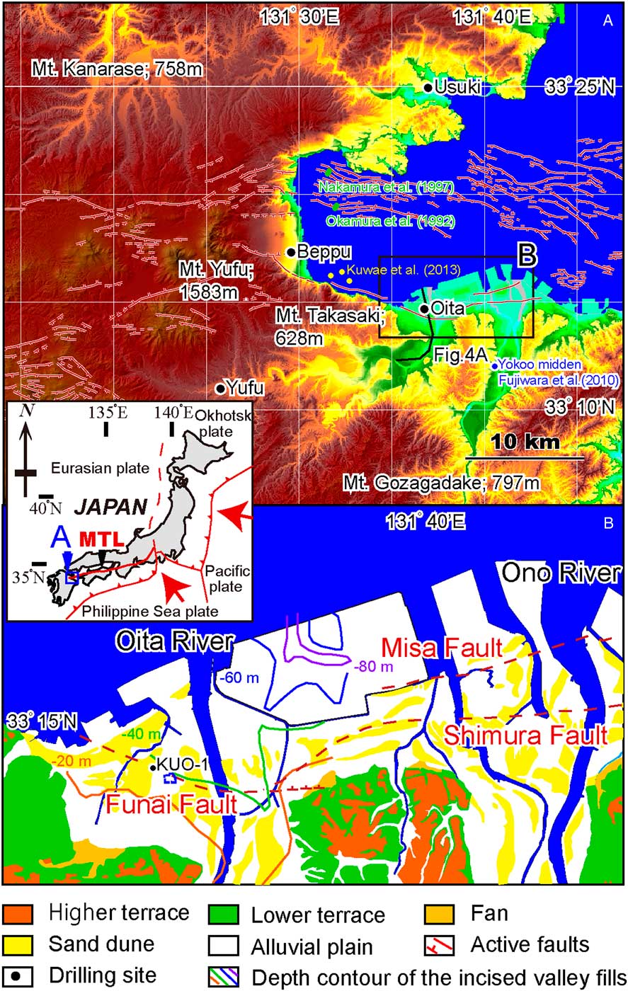
The Funai Fault, part of the Oita Plain–Yufuin Fault Zone, which consists of normal faults along the southern margin of Beppu Bay (Figure 1A), is located beneath the city of Oita, one of the most popular downtown areas on Kyushu island. The last paleoseismic event associated with the fault was determined to have occurred at 1540–2350 yr BP, based on the results of an arrayed drilling survey around Funai Castle (Chida et al. Reference Chida, Takemura, Matsuda, Shimazaki, Ikeda, Okamura, Mizuno, Matsuyama and Shuto2003). The slip rate during the last 7300 yr was also identified as 2.2–2.5 mm/yr (Chida et al. Reference Chida, Takemura, Matsuda, Shimazaki, Ikeda, Okamura, Mizuno, Matsuyama and Shuto2003) on the basis of vertical displacement of the Kikai-Akahoya tephra (Machida Reference Machida2002). The recurrence interval of paleoseismic events of this fault has not reported because it is difficult to identify the events from thick coastal sediments. However, recurrence intervals of the active submarine faults in the northwestern part of Beppu Bay were reported as 1800–2900 yr (Okamura et al. Reference Okamura, Shimazaki, Nakata, Chida, Miyatake, Maemoku, Tsutsumi, Nakamura, Yamaguchi and Ogawa1992; Nakamura et al. Reference Nakamura, Okamura, Shimazaki, Nakata, Chida, Suzuki, Okuno and Ikeda1997) (Figure 1B). The Ministry of Education, Culture, Sports, Science and Technology of Japan (2016) is performing studies on the recurrence intervals of paleoseismic events to facilitate long-term assessments of future seismic disasters. To obtain geological information pertaining to the Funai Fault, core KUO-1 was collected from the down-dropped side of the fault, and sedimentary facies, mollusk assemblages, and radiocarbon (14C) ages were determined. The 14C age offsets of shell and plant pairs were determined from the sediment core. Then the results were compared to values from Hakata Bay, the northern coast of Kyushu, (Nakanishi et al. Reference Nakanishi, Hong, Shimoyama, Sato, Park and Lee2017a), the Korean Peninsula (Nakanishi et al. Reference Nakanishi, Hong, Sung and Lim2013, Reference Nakanishi, Hong, Sung, Sung and Nakashima2015a, Reference Nakanishi, Hong, Sung, Nakashima, Nahm, Lim and Katsuki2017b), and the best-fit wiggle matching-based age/depth model from the deepest parts of the Beppu Bay (Kuwae et al. Reference Kuwae, Yamamoto, Ikehara, Irino, Takemura, Sagawa, Sakamoto, Ikehara and Takeoka2013).
(A) Topograpic map of the area around Beppu Bay (modified after Nakanishi et al. Reference Nakanishi, Takemura, Matsuyama, Saito and Katsuki2015b and Ministry of Education, Culture, Sports, Science and Technology of Japan 2016). Fault lines are based on the Headquarters for Earthquake Research Promotion (2005). (B) Geographic interpretation of the Oita area after the Geospatial Information Authority of Japan (2011) with fault lines (Okada et al. Reference Okada, Nakata, Chida and Une2001; Headquarters for Earthquake Research Promotion 2005). Depth contour lines of the incised valley fills are after Chida (Reference Chida1987). MTL is the Median Tectonic Line active fault system.

STUDY SITE
The Oita Plain–Yufuin Fault Zone occupies the western portion of the Median Tectonic Line active fault system (Okada Reference Okada1968; Tsutsumi and Okada Reference Tsutsumi and Okada1996), an arc-bisecting dextral fault system (Figure 1A). The Oita Plain, at the southern margin of Beppu Bay, was formed by two major rivers, the western Oita River and the eastern Ono River (Figure 1B), under the influence of the Oita Plain–Yufuin Fault Zone including the active Funai, Misa, and Shimura faults (Chida Reference Chida1987; Chida et al. Reference Chida, Takemura, Matsuda, Shimazaki, Ikeda, Okamura, Mizuno, Matsuyama and Shuto2003). Sediment core KUO-1 was obtained from the alluvial plain of the Oita River (33°14′33.9′′N, 131°36′26.6′′E; elevation +2.38 m) (Figure 1B). This drilling site was located on the subsidence side of the Funai Fault (Okada et al. Reference Okada, Nakata, Chida and Une2001; Headquarters for Earthquake Research Promotion 2005; Ministry of Education, Culture, Sports, Science and Technology of Japan 2016) at the boundary of the western sand dune region and the eastern alluvial plain (Geospatial Information Authority of Japan 2011) (Figure 1B). The coastal water around Beppu Bay is influenced by the warm Kuroshio Current, which originates from the southern sea. This bay has a water surface area of 475 km2 and a maximum water depth of ca. 70 m. The maximum tidal range is ca. 2.6 m. Volcanic rocks and sediments of the Pleistocene Epoch form the bedrock of the catchment, and no carbonate rocks are present around the bay.
METHODS
Sedimentological Analysis
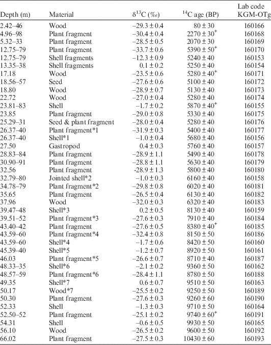
Sediment core with a length of 70 m was collected at 1.0-m intervals using a double-walled tube sampler. The recovery was almost 100%. The cores were split, described, and photographed; their lithologies, colors, sedimentary structures, textures, contract characteristics, fossil components, and grain sizes were described; and X-radiographs were taken from slab samples (5 cm wide × 25 cm long × 1 cm thick). To recognize non-visible changes in magnetic properties and grain sizes, initial magnetic susceptibility was measured by a Bartington MS2 magnetic susceptibility system. In addition, for improved understanding of sedimentary environments, mollusc assemblages were identified on the basis of the classification of Okutani (Reference Okutani2000). Plant and carbonate shell samples of good condition were collected from the core for accelerator mass spectrometry (AMS) 14C dating. The sampling depths are listed in Table 1, and the middle depths with lengths larger than 2 cm were used in this research study.
14C ages from core KUO-1. Errors are 1σ ranges. Materials with an asterisk (*1–7) are those used to measure the marine reseavoir age. 14C ages with a cross (+) were interpreted from reworked samples.

AMS 14C Dating
To establish a stratigraphically consistent chronology for core KUO-1 and to evaluate the marine reservoir effect, we used AMS dating to measure the 14C ages of 25 terrestrial macrofossils and 16 calcareous marine samples. Fragile samples such as twigs and thin bivalves as well as articulated shells of dominant species were selected as often as possible because they are less likely to have been reworked. Samples were washed repeatedly with an ultrasonic cleaner and then cleaned chemically using acid-alkali-acid or acid treatment to remove secondary contaminants. Samples of 14C-free wood and the IAEA C-1 reference material were treated using the same procedure for control measurements. The carbonate samples were powdered by mortar and pestle. The samples NIST OxII, IAEA C-7, and C-8 were combusted in an elemental analyzer, and the CO2 gas was purified cryogenically in a high-vacuum automatic preparation system (Hong et al. Reference Hong, Park, Kim, Woo, Kim, Choi and Kim2010a; Park et al. Reference Park, Hong, Woo, Choi, Kim and Kim2010) and then converted into graphite by reduction of Fe powder with hydrogen gas in a quartz tube. The 14C ages of the samples were measured with the standard samples at the AMS facility at the Korea Institute of Geosciences and Mineral Resources (KIGAM) (Hong et al. Reference Hong, Park, Sung, Woo, Kim, Choi and Kim2010b). The carbon isotopic fractionations were corrected by δ13C values, measured at the AMS facility. The 14C ages of the terrestrial samples were converted into calendar dates using IntCal13 (Reimer et al. Reference Reimer, Bard, Bayliss, Beck, Blackwell, Bronk Ramsey, Buck, Cheng, Edwards, Friedrich, Grootes, Guilderson, Haflidason, Hajdas, Hatté, Heaton, Hoffmann, Hogg, Hughen, Kaiser, Kromer, Manning, Niu, Reimer, Richards, Scott, Southon, Staff, Turney and van der Plicht2013) and CALIB 7.1 (Stuiver et al. Reference Stuiver, Reimer and Reimer2017).
RESULTS
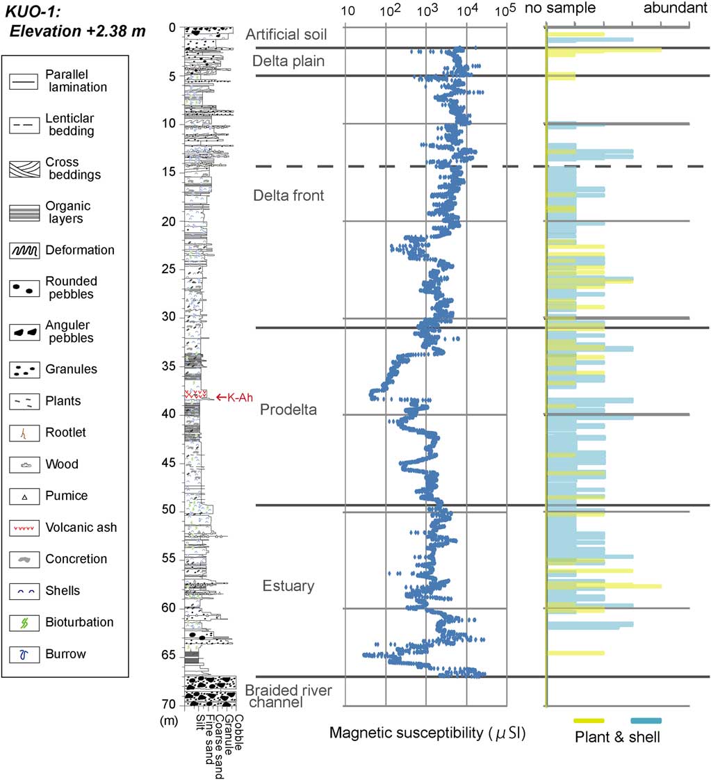
Based on our core analysis, six sedimentary facies were identified, namely braided river channel, estuary, prodelta, delta front, delta plain, and artificial soil, as illustrated in Figure 2. These lithofacies, along with remarks, depositional environments, and ages of the facies, are described below. The 14C ages are listed in Table 1, and an age/depth diagram is provided in Figure 3.
Sedimentary column, initial magnetic susceptibility, and relative amounts of plant material and shells of core KUO-1.

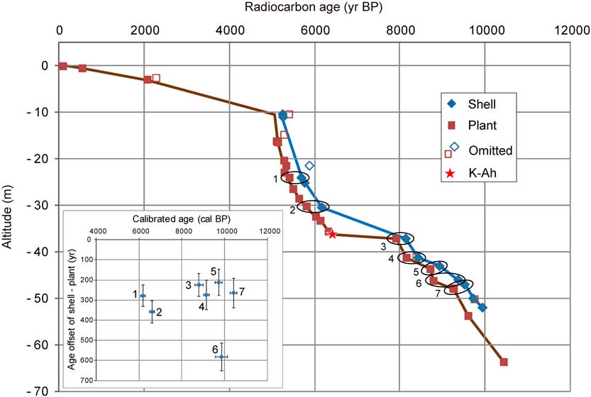
AMS 14C ages and offsets between shell and plant pairs from core KUO-1.

Braided River Facies (core depth of 66.95–70.00 m)
Description
This sediment consisted of alternating beds of sandy gravel layers with thicknesses of 30–120 cm and gravel-supported sand layers with thicknesses of 20–30 cm. The gravel clasts were subangular to subrounded, and the clast diameters were mainly from 5–180 mm. The matrix portion mainly consisted of a mixture of medium and coarse sand. No samples for 14C dating were found in this sediment.
Interpretation
We interpreted this sediment as braided river channel sediment because such alternating beds of sandy gravel and gravel-supported sand were commonly reported in bedload environments (Maill Reference Maill1977, Reference Maill1992). Similar layers of sandy gravel were previously reported from the Oita Plain by Chida (Reference Chida1987), and were interpreted as having formed in the last glacial period.
Estuary Facies (core depth of 49.08–66.95 m)
Description
This sediment consisted of alternating beds of sand/gravel and mud. Plant remains, peaty layers, burrows, and shells of intertidal species such as Moerella rutila, Mactra veneriformis, Meretnix lusoria, Batillaria zonalis, B. multiformis, Cerithidea cingulata, and Reticunassa festiva were commonly found throughout this sediment. 14C ages of five plant samples from 50.17–66.02 m depth were 9250–10,430 BP, and the ages of three shells from 49.35–54.31 m depth were 9510–9930 BP.
Interpretation
The combination of terrestrial plant remains, rootlets and peat, and intertidal burrows and mollusks indicates that this sediment formed in an environment with freshwater from a terrestrial source and saline water from a marine source, such as an estuary. The increase in plant detritus with decreasing depth indicates an upward shallowing of water depth associated with a change in sea level and/or transportation of sediments. The absence of rootlets in the upper part of this sediment implies that it was not deposited in an area shallower than an intertidal zone.
Prodelta Facies (core depth of 31.00–49.08 m)
Description
This sediment consisted of fine soft mud with shells and a few layers of fine sand. The concentration of plant fragments was higher toward the upper and lower portions. Subtidal species of mollusks such as Anodontia stearnsiana, Reticunassa multigranosa, Theora fragilis, and Echinocardium cordatum were found throughout this facies. Bioturbation, burrows, and concretions were also found throughout this sediment. A tephra horizon was identified by a high concentration of volcanic glass with bubble walls and small amounts of brown glass at a depth of 37.40–38.39 m. This was correlated with the widespread Kikai-Akahoya tephra (K-Ah: Machida Reference Machida2002). A medium sand layer with a thickness of 2 cm was identified at the base of the K-Ah. 14C ages of nine plant samples from 32.56–48.58 m depth were 5800–8780 BP, and the ages of five shells from 32.80–48.34 m depth were 6160–9360 BP.
Interpretation
The fine mud with a few terrestrial plant remains and abundant marine shells suggests that this sediment was deposited in a deeper water environment, such as an inner bay. The increase in plant detritus with decreasing depth indicates an upward shallowing of water depth associated with a change in sea level and/or transportation of sediments. The medium sand layer at the base of the K-Ah was identified as a tsunami deposit generated by pyroclastic flows of the K-Ah eruption (Maeno et al. Reference Maeno, Imamura and Taniguchi2006; Maeno and Imamura Reference Maeno and Imamura2007). This tsunami deposit was also reported at the Yokoo midden (Fujiwara et al. Reference Fujiwara, Machida and Shiochi2010), southwest of the drilling site (Figure 1A). Shells of open sea species, such as R. multigranosa, Zeuxis castus, and Niotha variegata, at a depth of 32.00–33.82 m imply currents from outside of the inner bay.
Delta Front Facies (core depth of 4.95–31.00 m)
Description
This upward-coarsening succession was characterized by thickly interlaminated to thinly interbedded very fine-to-fine sand and mud with shell fragments. This sediment consisted of two units: an upper unit of alternating beds of cross-lamated sand/gravel layers and mud layers from depths of 4.95–14.38 m, and a lower unit of parallel-laminated sand layers and mud layers from 14.38–31.00 m. Bioturbation, burrows, and concretions occurred throughout this sediment. Shells of intertidal species of mollusk such as M. lusoria and Umbonium moniliferum were recognized at the depth of 9.92–13.28 m. In addition, shells of intertidal species of mollusk, such as Pillucina pisidium and Nitidotellina hokkaidoensis, and intertidal and subtidal species, such as Fulvia mutica and E. cordatum, were recognized at the depth of 15.65–30.60 m. The 14C ages of 12 plant samples from 4.97–30.91 m depth were 6160–9360 BP, and the ages of five shells from 12.77–27.50 m depth were 5240–5760 BP.
Interpretation
The upward-coarsing trend is evidence of increasing discharge of coarser materials and increasing hydraulic intensity. The change in molluscan assemblages from subtidal to intertidal species indicates that the marine environment became shallower, probably as a result of river-mouth progradation. Thus, we concluded that this sediment formed in a delta front environment. The average accumulation rate was about 2.1 mm/yr. Shells of open sea species, such as Mactra nipponia and Pecten albicans, at a depth of 25.08–27.71 m imply currents from outside from the inner bay.
Delta Plain Facies (core depth of 2.37–4.95 m)
Description
This sediment could be divided into an upper unit of alternating beds of sandy mud and coarse sand and a lower unit of alternating beds of sand and gravel. No shells of marine to brackish species or burrows were found in this sediment. The 14C age of two plant fragments collected from a depth of 2.44–2.89 m was 90–540 BP.
Interpretation
We inferred that this sediment accumulated on a delta plain because it contains terrestrial plants but no shells of marine or brackish or burrows.
Embankment (core depth of 0.00–2.37 m)
Description
This sediment was divided into an upper and lower sandy gravel layer. A piece of pottery and a piece of brick were found at the upper part of this sediment.
Interpretation
We concluded that this sediment was an embankment formed by humans because of the artificial products in it and the land use history.
Accumulation Curves
Based on 41 14C ages from core KUO-1, two accumulation curves were constructed according to the ages of plant remains and shells, which were interpreted by the scattering pattern in an age/depth diagram and by stratigraphic interpretation (Figure 3). These curves were consistent with the eruption age of K-Ah of 7165–7303 cal BP (Smith et al. Reference Smith, Staff, Blockley, Bronk Ramsey, Nakagawa, Mark, Takemura and Danhara2013) and the depth of concentration of the volcanic glass (Figure 3). The age/depth diagram indicated that six (6/41=15%) samples should be ignored in the interpretation of accumulation curves and for marine reservoir effects. These samples included a plant fragment from a depth of 52.51 m that was 140 yr older than a wood fragment from a depth of 56.10 m, a plant fragment from a depth of 43.41 m that was 230 yr older than a plant fragment from 43.595 m, a shell from a depth of 23.82 m that was 470 yr older than a shell from 26.385 m, a plant fragment from a depth of 12.77 m and a wood fragment from a depth of 17.18 m that were 150–290 yr older than a seed from 18.565 m, and a plant fragment from a depth of 4.97 m that was 200 yr older than a plant fragment from a depth of 5.325 m. We determined that the samples, KGM-OTg 160191, 160185, 160155, 160170, 160171, and 160168, were reworked because no problems were found in the sample treatment and measurement procedures. These offsets are similar to previously reported values of 200–300 yr from plant samples in the Holocene sediments of Hakata Bay (Nakanishi et al. Reference Nakanishi, Hong, Shimoyama, Sato, Park and Lee2017a).
Marine Reservoir Effects
Eight offsets in 14C age between eight plant remain/shell pairs induced by the reservoir effect were interpreted from the same and adjacent horizons of core KUO-1 during 6000–11,000 cal BP (Figure 3). The calculated reservoir ages (R) ranged from 210±70 to 580±70 yr, and the total average value was 310±130 yr. The value from the estuary sediment was 260±70 yr (no. 7 in Figure 3), the average value from the prodelta sediment was 330±150 yr (n=5: nos. 2-6 in Figure 3), and the value from the delta front sediment was 270±50 yr (no. 1 in Figure 3). These results were consistent with previously determined values: 310±150 yr (n=33), within 60±140 to 800±150 yr, that was obtained from two cores of Hakata Bay during 2000–9000 cal BP (Nakanishi et al. Reference Nakanishi, Hong, Shimoyama, Sato, Park and Lee2017a). However, these average values and standard deviations were slightly smaller than the values from the Korean Peninsula, 380±190 yr (n=48) within 60±60 to 1000±60 yr that was determined from seven cores of the west and south coast during 100–8200 cal BP (Nakanishi et al. Reference Nakanishi, Hong, Sung and Lim2013, Reference Nakanishi, Hong, Sung, Sung and Nakashima2015a), and 450±230 yr (n=9) within 120±80 to 800±70 yr that was measured from a core of the east coast during 300–7300 cal BP (Nakanishi et al. Reference Nakanishi, Hong, Sung, Nakashima, Nahm, Lim and Katsuki2017b). The significant chronological increasing trend of the marine reservoir effect was not identified in the Oita area, nevertheless it was recognized in two cores of Hakata Bay during 7500–9000 cal BP (Nakanishi et al. Reference Nakanishi, Hong, Shimoyama, Sato, Park and Lee2017a) and four cores of the west and south coast of Korea during 3000–4000, 6500–7000, and 7500–8000 cal BP (Nakanishi et al. Reference Nakanishi, Hong, Sung and Lim2013, Reference Nakanishi, Hong, Sung, Sung and Nakashima2015a). On the other hand, these average values were approximately 100 yr larger than the values reported by Kuwae et al. (Reference Kuwae, Yamamoto, Ikehara, Irino, Takemura, Sagawa, Sakamoto, Ikehara and Takeoka2013), 0–330 yr, and the total average value of the best-fit wiggle matching-based age/depth model of 240–2500 cal BP of bay sediments from Beppu Bay of 180±100 yr.
Activity of the Funai Fault
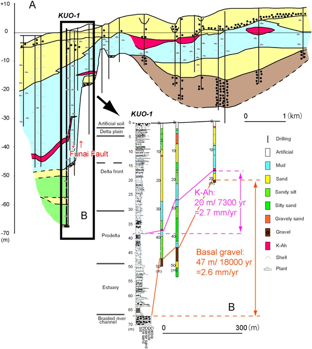
Two horizons of core KUO-1, the top of the braided river channel sediments and the base of the K-Ah tephra, were correlated with those in a drilling log obtained 300 m south of our drilling site on the uplifted side of the Funai Fault (Figure 4). The vertical offsets, 47 m/18,000 cal BP and 20 m/7300 cal BP, suggested a vertical component slip rate of 2.6–2.7 mm/yr. This slip rate was consistent with the previously determined value of 2.2–2.5 mm/yr reported by Chida et al. (Reference Chida, Takemura, Matsuda, Shimazaki, Ikeda, Okamura, Mizuno, Matsuyama and Shuto2003) based on the vertical displacement of the K-Ah tephra in a seismic cross-section and drilling logs along the Funai Fault. These slip rates were also consistent with the value (at least 1.4 mm/yr) from the subsidence side of Asamigawa Fault (Nakanishi et al. Reference Nakanishi, Takemura, Matsuyama, Saito and Katsuki2015b), western extension of Funai Fault. The accumulation curves within the prodelta sediments have two steps of slow to rapid accumulation periods during 8700 to 10,400 cal BP (Figure 3). The first step at the depth of 48.58 m is marked by a change in sedimentation rate from 3.4 mm/yr to 35.4 mm/yr. The other step at the depth of 43.595 m reflects a change from 4.4 mm/yr to 17.0 mm/yr. These significant steps might be associated with coseismic subsidence events caused by motion of the Funai Fault and interseismic periods. The recurrence interval of these events seems to be ca. 700 yr. This interval is clearly smaller than the interval of 1800–2900 yr from active submarine faults in the northwestern part of Beppu Bay (Okamura et al. Reference Okamura, Shimazaki, Nakata, Chida, Miyatake, Maemoku, Tsutsumi, Nakamura, Yamaguchi and Ogawa1992; Nakamura et al. Reference Nakamura, Okamura, Shimazaki, Nakata, Chida, Suzuki, Okuno and Ikeda1997) (Figure 1A). The difference might be associated with the paleoseismic segmentation of active faults in this area. On the other hand, there were changes in sedimentation rate caused by the lower accumulation rate of the prodelta sediment (5.4 mm/yr) compared to the rates of the estuary (13.4 mm/yr) and delta front (7.2 mm/yr). Similar changes in accumulation curves in transgressive sediments were also reported on the western margin of the Niigata Plain (Tanabe et al. Reference Tanabe, Nakanishi and Yasui2010), central Japan, around an active thrust with a 3 mm/yr vertical slip rate (Nakanishi et al. Reference Nakanishi, Miyachi, Tanabe, Urabe, Yasui and Wakabayashi2010). Additional analyses of 14C dates, diatom assemblages, and grain size will be needed to evaluate the abrupt changes in the trasgressive environments in the Oita area.
(A) Geologic and geographic cross-section along the Oita River. The location of the profile is indicated in Figure 1. The drill logs are based on Chida (Reference Chida1987) and Kunijiban. (B) Geologic cross-section across the Funai Fault and the vertical slip rate.

CONCLUSIONS
Six sedimentary facies, namely braided river channel, estuary, prodelta, delta front, delta plain, and artificial soil, were identified on the down-dropped side of the Funai Fault, in downtown area of the city of Oita. The vertical slip, calculated based on the displacements of the braided river channel sediments of the last glacial period and the base of the K-Ah tephra, was 2.6–2.7 mm/yr. Reservoir ages were determined from eight marine shell and terrestrial plant pairs in the sediments of the estuary, prodelta, and delta front facies, and the average value during 6180–10,410 cal BP was 310±130 14C yr, within 210±70 to 580±70 14C yr. This value is similar to values from Hakata Bay and the Korean Peninsula. These R values are associated with the warm Kuroshio and Tsushima Currents.
ACKNOWLEDGMENTS
The authors thank Dr. Gyujun Park and Mr. Jong-Geol Lee for their support in the AMS 14C measurement at KIGAM. This work was supported by the Comprehensive Research Project for the Beppu-Haneyama Fault Zone (East Part of the Oita Plain to Yufuin Fault Zone) of the Ministry of Education, Culture, Sports, Science and Technology of Japan.