

Violent conflict shapes societies and individuals. Recent ethnographic work on modern-day factional and ethnic conflict highlights the emergent local political orders and reconfigured social networks that arise in war zones (Arjona Reference Arjona2014; Lubkemann Reference Lubkemann2008; Wood Reference Wood2008), as well as the altered subjectivities, identities and modes of interaction produced by the threat of violence (Das Reference Das2008; Das et al. Reference Das, Kleinman, Ramphele and Reynolds2000; Green Reference Green1999; Malkki Reference Malkki1995; Whitehouse et al. Reference Whitehouse, McQuinn, Buhrmester and Swann2014). While these contemporary conflicts involve very different stakeholders and fault lines from the ancient contexts archaeologists study, the threat of violence in the past must also have shaped how people interpreted and enacted their roles in a social world, working through both material and intangible realms. For archaeologists, one aspect of that process is especially amenable to study: the making of defensive communities.
Defensive settlements have traditionally been viewed by archaeologists as evidence of conflict and warfare. While these sites are indeed built to protect their inhabitants from violent threat, they do much more than that. They simultaneously work as social constructions that create and reinforce certain ways of living. This paper considers the particular kind of communities produced by defensive relocation and nucleation, drawing on a general perspective that considers how communities are constructed, reproduced and negotiated (e.g., Birch Reference Birch and Birch2013a,b; Canuto & Yaeger Reference Canuto and Yaeger2000; Rautman Reference Rautman2014). To clarify, by ‘defensive settlements’ I here mean not specialized military installations or strategic outposts staffed by a few soldiers, but defensive villages or towns: settlements built with an eye to defence, fortified and/or located defensively because of a serious risk of attack, but with the full range of people and daily activities that one might expect in any village. Nevertheless, living in defensive settlements entails special issues of making and organizing community. In such places, fissioning or emigrating is far more perilous and population growth more desirable. Defensive interdependence places special demands on inhabitants to achieve mutual trust and solidarity. Because defensive responsibilities are so critical and so costly, free-riding is especially offensive, and deviance or suspected treachery is intolerable. Fortifications, where present, serve to demarcate the community starkly from the outer world, but they also put a premium on protected space, resulting in especially dense residential packing and potentially unequal protection among residents. Defensive communities are often places of rapid aggregation, meaning that they participate in the basic problems posed by nucleation itself, from social friction to sanitation. Aggregation also sets in motion special dynamics between founders, daughter families and latecomers. What approaches did the residents of defensive settlements take to these issues? How did people create communities that were both fortress and home?
Coalescence and defensive communities
An excellent starting point for considering these issues is Stephen Kowalewski's discussion of coalescence (Kowalewski Reference Kowalewski, Pluckhahn and Ethridge2006; Reference Kowalewski, Gregory and Wilcox2007; Reference Kowalewski and Birch2013). While this term was originally developed for native peoples of the southeastern United States who gathered into large settlements in the historic era (Ethridge & Hutson Reference Ethridge and Hudson2002), Kowalewski expands coalescence to a general phenomenon: the rapid aggregation of big new settlements in times of crisis, often after the collapse of a previous social order. As populations nucleated under pressure, they needed to establish consensual rules for living together, sometimes with the old ways of ordering society destroyed and discredited. Kowalewski (Reference Kowalewski, Gregory and Wilcox2007, 441) argues that coalescence produced similar patterns cross-culturally, including collective defence, the intensification of subsistence agriculture to support dense populations, community organization through lineage descent systems and corporate leadership or collective decision-making, although he does not explore these similarities in much depth. These transformations were ‘totalizing’ in that they affected all parts of social life and had long-lasting effects, precluding reversal to more dispersed patterns. Recently, Jennifer Birch's (Reference Birch2013b) edited volume extended this concept to examine multiple cases of rapid settlement aggregation, from the contact-era Huron to Iron Age Crete. Birch (Reference Birch and Birch2013a) particularly emphasizes the importance of the built environment in conditioning social relations in these new settlements.
By highlighting what Kowalewski (Reference Kowalewski, Gregory and Wilcox2007) calls ‘the work of making community’, the concept of coalescence points the way toward reconceptualizing the settlements produced by defensive relocation and nucleation, not just as communities, but as social experiments sometimes conducted under severe external pressure. Here, I highlight several questions about such defensive communities that might particularly merit our attention. Then I turn to a specific case from the late pre-Columbian Andes to explore these questions.
Defensive nucleation and scalar stress
Defensive communities are often places of relatively rapid aggregation. For instance, Birch and Williamson (Reference Birch, Williamson and Birch2013) outline the burst of Iroquoian nucleation from small dispersed villages to new fortified towns of 1500–2000 people, as warfare escalated in the middle fifteenth to early sixteenth centuries. Large defensive settlements shared with first cities, boom-towns and early villages of the Neolithic transition the basic problems posed by nucleation itself (Bandy & Fox Reference Bandy and Fox2010; Byrd Reference Byrd1994; Kuijt Reference Kuijt2000): sanitation and disease, pressure on local resources, the coordination of decisions among many people and new vexations of privacy, envy and difficult neighbours. But these pressures would have been intensified by a context of violent threat. At defensive communities there are major disincentives to fissioning and emigration. Ideally, such places must continue to attract migrants or foster high internal birth rates, because there is strength in numbers. (In addition, a larger population exponentially eases the burden of building and maintaining defenses: a circular defensive stockade that encloses four times the population is just twice as long, halving the labour burden on the inhabitants.) Finally, crowding is often exacerbated by the need to live packed on a naturally constrained defensive landform, or within fortifications whose ambit cannot be expanded without substantial costs.
Recent work on swift demographic expansion (e.g. Bandy Reference Bandy2004; Bandy & Fox Reference Bandy and Fox2010; Bocquet-Appel & Bar-Yosef Reference Bocquet-Appel and Bar-Yosef2008; Kuijt Reference Kuijt2000) highlights the need to generate practices, institutions and architectures that allow large numbers of people to live packed together at a greater scale and density than before, sometimes with socially diverse populations. Archaeologists have particularly argued that the ‘scalar stress’ of decision-making and conflict mediation in large populations might result in the rise of higher-level political and/or ritual integration (Adler Reference Adler, Lipe and Hegmon1989; Adler & Wilshusen Reference Adler and Wilshusen1990; Bandy Reference Bandy2004; Byrd Reference Byrd1994; Fletcher Reference Fletcher1995; Johnson Reference Johnson, Renfrew, Rowlands and Segraves-Whallon1982; Tuzin Reference Tuzin2001). There is clearly a broad positive relationship between population scale and political hierarchy (Carneiro Reference Carneiro1967; Fletcher Reference Fletcher1995; Lekson Reference Lekson1985), although the relationship is rather loose (Feinman Reference Feinman2011), and important exceptions spring to mind like Catalhöyük (Düring Reference Düring and Birch2013) and Jenne-jeno (McIntosh Reference McIntosh2005) that, in Birch's words (Reference Birch and Birch2013a, 2), ‘give the impression of being too large to be classified as villages but retain many aspects of social organization associated with segmentary village societies’. Alternatively, integration might be achieved through collective ceremony and public architecture, as Adler and Wilshusen (Reference Adler and Wilshusen1990) argue, pointing to the building of great kivas at moments of swift aggregation in prehistoric Southwestern pueblos, although such facilities are notably absent in some cases (e.g. Wallace & Lindeman Reference Wallace, Lindeman and Birch2013). It is an open question whether either ritual or political integration should be present at large defensive settlements. Is scalar stress experienced or managed in the same way when fission and emigration are so difficult? Nevertheless, daily life in a large, dense settlement must have entailed some minimum complement of shared attitudes and behaviours. In contemporary cities, some of these behaviours are top-down rules or laws, like driving on the right in the United States. But others are self-generated and nearly unconscious, forming a part of daily habitus: in crowded sidewalks and hallways, Americans walk on the right. What practices arose to mediate internal conflict and crowding in dense defensive communities?
Defensive solidarity and conformity
Defensive solidarity is of paramount importance at defensive communities, and this fact has implications for how social difference and political authority are handled. Where the threat was severe, I would suggest that there was often a significant deemphasis on individual status differentiation and wealth display.Footnote 1 Instead, one may detect corporate modes of organization and active processes of social levelling, for instance at some fortified settlements of Iron Age Europe (McCartney Reference McCartney2012; Sastre Reference Sastre2008; see Thurston Reference Thurston, Price and Feinman2010). Kowalewski (Reference Kowalewski, Pluckhahn and Ethridge2006) likewise argues that communal/corporate decision-making is a feature of coalescence, rather than centralized political hierarchies. This may partly result from the fact that defensive settlements often emerge after the collapse of centralized political systems, or on their outer fringes, and react against these hierarchical sociopolitical regimes. Recent perspectives on self-organization and anarchy, post-collapse developments and mountain peripheries (Angelbeck Reference Angelbeck2016; Boehm Reference Boehm, Beaver and Purrington1984; Fowles Reference Fowles and Pauketat2012; Galaty Reference Galaty and Ralph2013; Schwartz & Nichols Reference Schwartz and Nichols2006; Scott Reference Scott2009) pinpoint how, where hierarchical social orders have lost validity, people may invent forms of organization and legitimacy that not only de-emphasize permanent authority, but actively and consciously subvert it.
But in addition, levelling, conformity and identification with the corporate group are reinforced by the demands of defence, affecting how individual subjects understand their relation to society. Defensive interdependence entails strong identification with the community, as ‘us’ versus ‘them’ (Raffield et al. Reference Raffield, Greenlow, Price and Collard2016). Certainly, a context of threat furnishes powerful incentives for cooperative action such as the building of fortifications (Ikehara Reference Ikehara2016; Roscoe Reference Roscoe and Carballo2013). Defensive site plans in themselves reinforce solidarity: fortifications demarcate and define the social group of insiders versus outsiders (Kenzle Reference Kenzle1997), as do circular villages, which Rautman (Reference Rautman2016, 137) argues are the product of defensive aggregation, creating ‘a defined physical and social safe haven in an uncertain world’. Solidarity is also sustained by normative behaviours (Raffield et al. Reference Raffield, Greenlow, Price and Collard2016). Collective action theory (Blanton & Fargher Reference Blanton and Fargher2008; Carballo Reference Carballo2013; DeMarrais Reference DeMarrais2016) implies that defence might involve strong expectations governing the roles and responsibilities of group members, since collective defence is a critically important ‘public good’ for which free-riding cannot be tolerated. Indeed, solidarity and suspicion of difference are two sides of the same coin. McCartney (Reference McCartney2006), drawing on Ember and Ember's (Reference Ember and Ember1992) correlation between warfare and socialization for mistrust of non-kin (e.g. increased witchcraft accusations), highlights the potential for mistrust within defensive settlements, resulting in residential separation and internal barriers. So, in such places there may be both solidarity and suspicion, with mutual social monitoring and little tolerance for deviance from community norms. To what extent were conformity, separation and monitoring emphasized at ancient defensive communities? Did the demands of common defence favour forms of corporate sociality and group identification?
Internal differentiation: protection, priority and descent groups
Nevertheless, some forms of internal differentiation are also possible and even expected at defensive communities. Indeed, they are literally built in to the architectural fabric. Although some defensive site plans, such as circular villages with an internal plaza (Rautman Reference Rautman2016), ostensibly privilege no part of the resident population, others involve gradients of protection from the inner core to the outer fringes. Defensive settlements on hilltops or ridges, by their nature, contain more protected zones on the peak or the ridge-end and more vulnerable sides. At many fortified settlements, some residents lived outside the defences, either by design or as a side-effect of site growth or late, cost-conscious fortification of the inner core. While these residents could potentially take refuge from attack inside the walls, their homes and possessions were left vulnerable. For example, at villages in the Coast Salish area discussed by Angelbeck (Reference Angelbeck2016, 64), stockades enclosed plankhouses of high-class residents, leaving the dwellings of low-class families unprotected. Likewise, settlements with an inner citadel make a stark distinction between those living within and without the citadel walls.
Such inequalities of protection are typically related to the processes of aggregation and growth that create large defensive communities. These processes generate special, inherent inequalities between founding lineages, cadet branches and newcomers. Illuminating discussions of the colonization of frontiers and newly settled regions (Kopytoff Reference Kopytoff and Kopytoff1987; Schachner Reference Schachner2012; Van Gijseghem Reference Van Gijseghem2006) apply just as well to situations of settlement aggregation, highlighting the special advantages that founders enjoy: the debt relationships they accrue by attracting and sponsoring later migrants (kin and allies), the power to accept or reject new arrivals to their community, first claims to land and water and the general prerogative to define social rules and understandings. Founding families in defensive communities have, in addition, the right to claim especially well-defended house sites. Later immigrants may be welcomed, for they strengthen the group and bring potential external ties. Yet they may still be seen as second-class citizens, and—if they arrive after fortifications are built—possibly even free-riders. Latecomers who are themselves refugees from conflict may have lost family members and material and social resources, winding up as dependents at the bottom of the evolving social order.
In other words, the dynamic process of defensive aggregation highlights descent as critical to identity and interaction, echoing Kowalewski's prediction of corporate descent groups at coalescent settlements. This phenomenon is evident in well-researched defensive settlements such as Grasshopper Pueblo in Arizona, where separate room blocks were built and inhabited by local and migrant lineages (Riggs Reference Riggs2007), the latter consisting in part of refugees who were disproportionately women and children (Lowell Reference Lowell2007). Different, and sometimes unequal, corporate descent groups are visible in the household clusters or partitioned spaces of many large defensive towns in the archaeological and ethnographic record (e.g. DeCorse Reference DeCorse, Monroe and Ogundiran2012; Lau Reference Lau2010; Tuzin Reference Tuzin2001; Wallace & Lindeman Reference Wallace, Lindeman and Birch2013).
Other considerations: landscape, region and the built environment
This paper focuses, for brevity's sake, on issues at the scale of the settlement, but it bears mentioning that defensive communities also face unique problems in their larger setting. Even while nucleation requires aggressive production of food and other necessities, the threat of attack favours intensive exploitation of local resources as opposed to more extensive strategies (Fowles et al. Reference Fowles, Minc, Duwe and Hill2007; VanDerwarker & Wilson Reference VanDerwarker and Wilson2015). It may lead to reduced or highly managed long-distance travel, trade and long-distance periodic ceremony. In other words, when faced with danger in the regional environment, people typically place a heavier reliance on local resources and local social networks. Nevertheless, alliance or dependence relationships with other settlements may be critical (Arkush Reference Arkush2011). Finally, settlements with a major investment in defensive architecture have a special, public relationship with the land: they are prepared to make a stand and defend their land claim through violence. These defensive communities may engage in marking, history-making and practices of memory in the broader landscape as well as inside the settlement. Such processes must be left for another paper, but they are no less important.
In defensive settlements and in their larger landscape, the built environment was fundamental in defining and reproducing community (Birch Reference Birch and Birch2013a; see Rapoport Reference Rapoport1982; Smith Reference Smith2011). The strength and solidarity of fortified communities were symbolized through constructed defences. Kinship organization might be spatialized in the layout of settlements (Ensor Reference Ensor2013), difference minimized or accentuated (Rautman Reference Rautman2016). Architecture impeded certain kinds of contact and facilitated others, shaping the daily flow of movement and knowledge (Moore Reference Moore2003). Internal barriers reduced penetrability for attackers (Peregrine Reference Peregrine1993), but also evoked mistrust of non-kin (McCartney Reference McCartney2006). Public spaces, private compounds, entrances and walkways concretely channelled everyday social interaction (Acuto Reference Acuto, Acuto and Zarankin2008; Byrd Reference Byrd1994). These architectural choices built protection, difference, knowledge and privacy into the physical fabric of the settlement.
These, then, are some points for thinking about defensive settlements as communities:
• How did the dense populations at defensive settlements organize themselves through the spatial layout of the settlement and its day-to-day functioning? What was shared with neighbours and what was kept separate? What was private and what was known?
• How did people express social cohesion, social distinction, and political authority? What were the realms of difference and what were the realms of conformity?
• How did defensive settlements grow? What was the relationship between first settlers, daughter families and later immigrants?
• How were these developments related to a context of threat?
While these issues are germane to defensive settlements in many other regions, the remarkable architectural preservation of late Andean hilltop sites, rivalling the better-studied late pre-Columbian settlements of the American Southwest, makes them especially rewarding places for investigating the nature of defensive community.
Andean hillfort settlements in the Late Intermediate Period
Defensive and fortified settlements are present for much of the Andean sequence, but they were particularly common in the Late Intermediate Period (LIP, c. ad 1100–1450), especially in the central and southern highlands. The collapse of the previous Wari and Tiwanaku states at about ad 1000 ushered in a period of political instability that ended with the expansion of the Inca empire in the fifteenth century. Adverse climate conditions pertained in this period, especially at first (Binford et al. Reference Binford, Kolata, Brenner, Janusek, Seddon, Abbott and Curtis1997; Bird et al. Reference Bird, Abbott, Rodbell and Vuille2011; Vuille et al. Reference Vuille, Burns and Taylor2012), and there is evidence for major social upheaval and intense warfare in the highlands, with the highest rates of both defensive settlement and craniofacial trauma in the whole sequence (Arkush & Tung Reference Arkush and Tung2013). It was a time remembered later as one of fierce war (Guaman Poma Reference Guaman Poma de Ayala1980 [1615]; Julien Reference Julien2003). There is great regionalization of styles and very little regional political unification in the highlands. The time is also marked by the widespread adoption in the central and southern Andes of chullpas (above-ground funerary towers) and other mortuary forms that made ancestral graves visible and relatively accessible to the living, perhaps in part because of the importance of ancestral priority and marking or claiming territory (Hyslop Reference Hyslop1977; e.g. Mantha Reference Mantha2009).
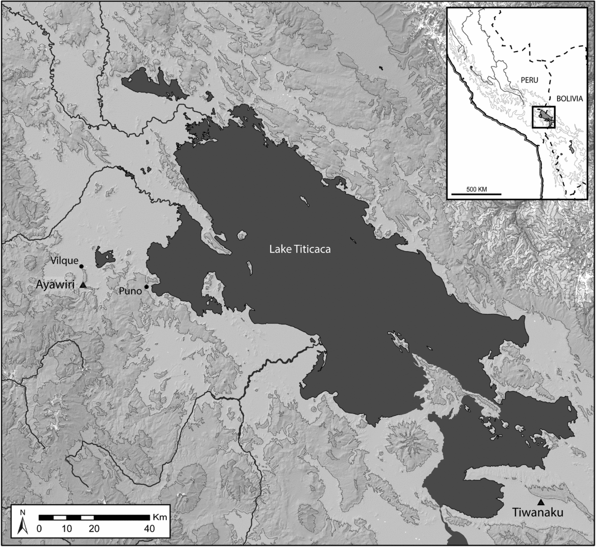
The Lake Titicaca Basin, the former heartland of Tiwanaku, exemplifies the transformations of the LIP. The region is a high-altitude, semi-arid alluvial plain with Lake Titicaca at the centre, surrounded by jutting hills and mountain ranges that step up to the Andean cordilleras to the east and west (Fig. 1). Agriculture depends on frost-resistant chenopods and tubers native to the area (e.g. quinoa, potatoes), while ample pasturage also supports large-scale herding of camelids (llamas and alpacas). In this region, a series of complex societies eventually culminated in the Tiwanaku state on the southern lake margin (Stanish Reference Stanish2003). After Tiwanaku collapsed c. ad 1000, most major settlements (including, eventually, the capital) were abandoned. In the first part of the LIP, small, ephemeral sites from the southern Titicaca basin are interpreted as the camps of mobile pastoralists (Janusek Reference Janusek, Vaughn, Ogburn and Conlee2004; Zovar Reference Zovar2012). In the northern and western basin, the early LIP is poorly understood, but the scarcity of sites securely dating to this time may suggest a hiatus of about 200 years during which settlement was relatively dispersed. We see the rapid emergence of hillfort society starting shortly before ad 1300 and lasting until the Inca conquest (Arkush Reference Arkush2011; Stanish Reference Stanish2003). While early colonial texts describe powerful native fiefdoms ruled by hereditary lineages of warlords (Arkush Reference Arkush2011; Julien Reference Julien1983), settlement patterns and the distribution of hillforts indicate much less political centralization than these texts imply (Arkush Reference Arkush2011; Frye & de la Vega Reference Frye, de la Vega, Stanish, Cohen and Aldenderfer2005; Stanish Reference Stanish2003; Stanish et al. Reference Stanish, de la Vega, Steadman, Chávez, Frye, Onofre, Seddon and Calisaya1997). In the post-collapse era, the material traditions associated with Tiwanaku religion and social hierarchy were also abandoned—palaces, platform-temple complexes, engraved monoliths, fine decorated ceramics and other prestigious goods—and material markers of authority and status were very limited.
The Titicaca basin, showing the location of Ayawiri.

Hillforts are present in the hundreds in the Titicaca basin in the LIP (Arkush Reference Arkush2011). They range from small hilltop outposts to large, permanently occupied, fortified towns that were the largest sites of their time and the seats of political authority, insofar as it existed (Arkush Reference Arkush2011; Stanish Reference Stanish2003). In this post-collapse era, the inhabitants of the large hillfort towns faced the challenge of coming up with new ways of organizing society: writing the rules of how to interact, worship, allocate wealth, bestow authority and cohere as defensive units.
Ayawiri (Machu Llaqta)
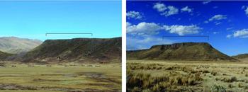
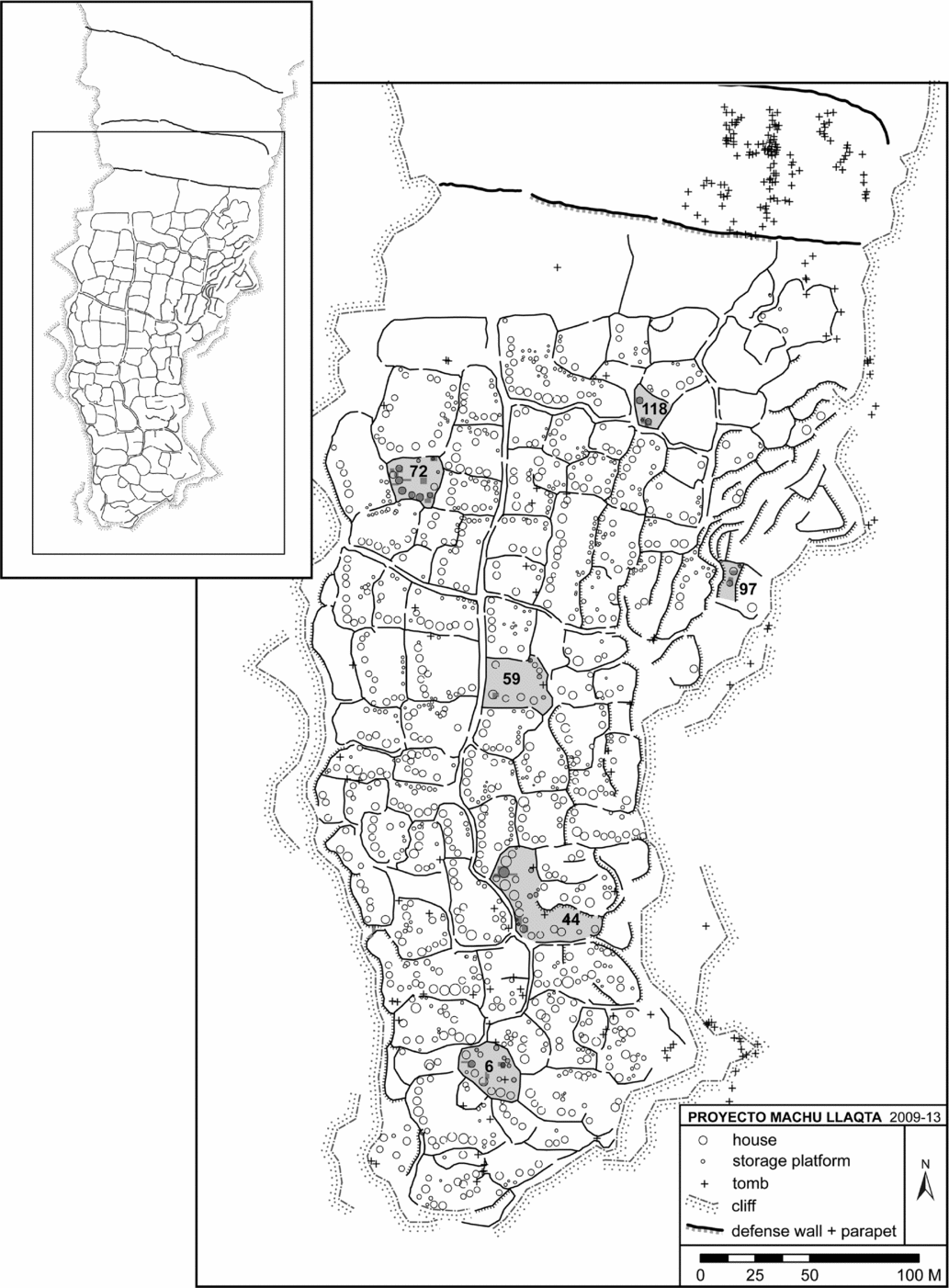
Ayawiri, also known as Machu Llaqta, is one of the biggest and architecturally densest of the Titicaca basin hillforts. It is located at 4150 m.a.s.l. on the southern tip of a high, flat mesa that extends south from the modern town of Vilque (Figs 2, 3). Cliffs surround the site except to the north, where there are three large defensive walls. The whole site, including the defensive walls, is 11 ha in size. Since the mesa is too high for cultivation, architecture remains well preserved on the surface. Most of the area inside the walls consists of separate walled compounds enclosing circular house foundations. Ayawiri has more than 660 houses crammed into 6 ha of residential occupation, and could have held up to 1000–2000 residents at its height. The residential area is divided by a walled, raised path on a south–north axis and several shorter paths. A large cemetery with about 125 cist tombs is located at the north end near the defensive walls, and there are additional tombs perched in the eastern cliff face. Several more clusters of tombs are located at the base of the hill on both the west and east sides; they are closer to Ayawiri than any other site, so it is logical to assume they were also used by Ayawiri's residents.
Views of Ayawiri from the east (left) and southwest (right).

Site map of Ayawiri. Shading shows compounds and units excavated.

From 2009 to 2013, Proyecto Machu Llaqta investigated Ayawiri and its local vicinity through detailed mapping, full-coverage survey and excavation (Arkush & Paredes Reference Arkush and Paredes2012a,Reference Arkush and Paredesb). Excavations in 2011 and 2012 focused on six residential compounds and two associated cemeteries (Fig. 3). The site is very shallow and intact house floors and use surfaces were reached within 30 cm of the modern ground level. Artefact assemblages left directly on the last living floors suggest a process of rapid abandonment without much depletion or scavenging (Arkush Reference Arkush2017). The site also has an early occupation in the Upper Formative (c. 500 bc–ad 400), followed by a very light Middle Horizon presence (c. ad 400–1000) and a possible hiatus. The architecture that is visible on the surface today corresponds with the maximum phase of use in the LIP, with radiocarbon dates in the range of cal. ad 1260–1500 (2 sigma); all of the present discussion concerns this occupation.
Organization within the compound
Walled residential compounds were the building blocks of the site and must have corresponded to meaningful social groups. Across the site they follow a basic plan. Their modularity and similarity say something both about social organization and about shared understandings of such organization.
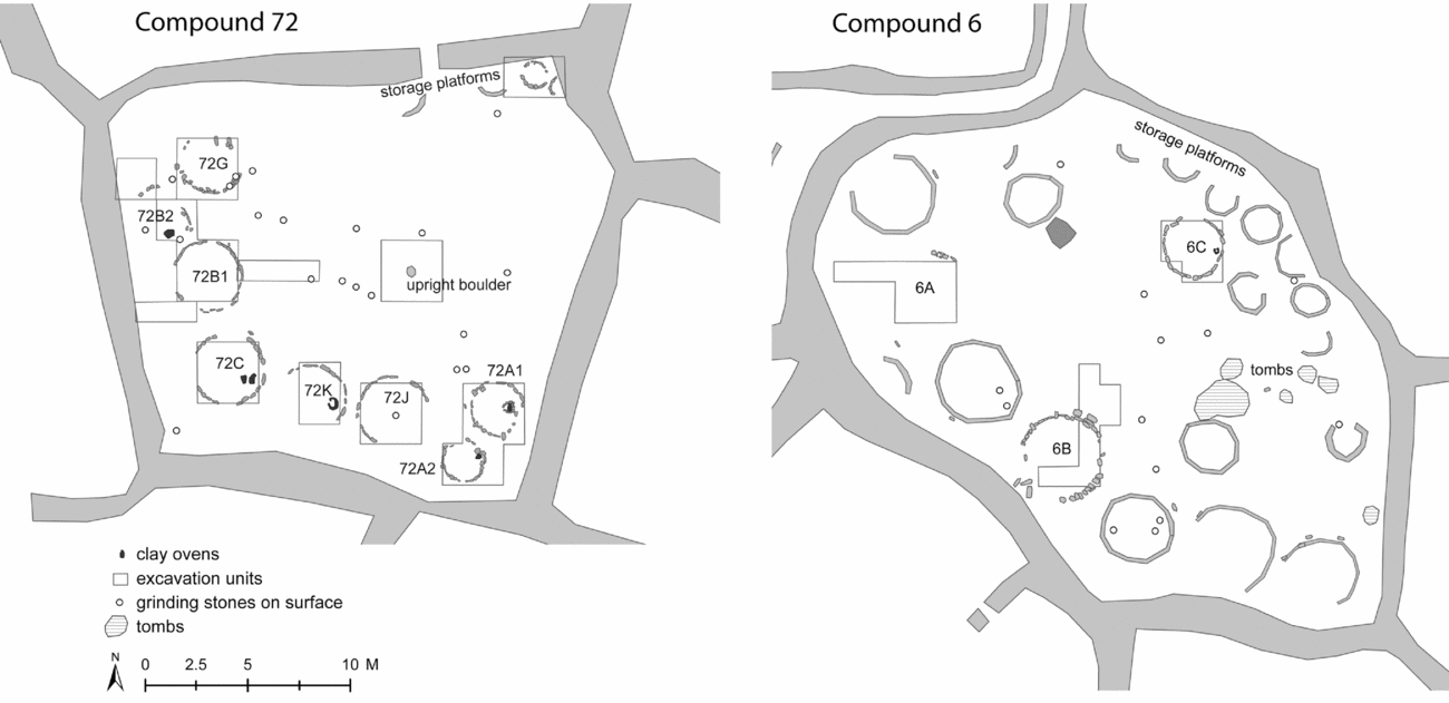
Compounds have an open central patio surrounded by structures lining the compound walls (Fig. 4). There are two basic kinds of structures. First, large circles of stone slabs are house foundations, with compacted use floors associated with artefacts. Compounds range from 1 to 19 houses in total, with most having 2–10 houses. Houses are usually placed on the south and west side of compounds, often on top of a low platform or rise of earth and rubble fill, with their entrances facing onto the patio. This placement is probably because the prevailing winds at the site come from the south and west (especially in the Andean winter, when they are stronger), so houses have their ‘backs’ to the wind and weather and were shielded by the compound wall. Second, there are small circular storage platforms less than 2 m in diameter, composed of a row of slabs retaining an inner fill of loose rock rubble, offering good drainage and perhaps some ventilation. Storage platforms may have been especially useful for storing potatoes and other tuber crops, which are more subject to rot than the other principal altiplano mainstay of chenopods (D. Browman pers. comm., 2016). They probably had a superstructure of reeds or thatch. Storage platforms are usually found on the north and east sides of compounds, where they are more exposed to wind.
Two of the residential compounds at Ayawiri.

The architecture leaves open a central patio area, which often has a number of grinding stones on the surface today. Patios in the middle of compounds are lightly compacted and have quite sparse artefacts, including occasional lithic debitage. Light midden areas can be found in exterior ‘toss zones’ just outside and to the side of house doorways, and deeper accumulations of midden were located behind houses and adjacent to the compound walls, in spots out of the way of daily traffic. Natural boulders are present in a number of compounds, and some have carved or pecked petroglyphs of curving or spiral motifs or parallel lines; in addition, smaller portable rocks with similar designs can be found on the surface of compounds (Arkush Reference Arkush and Strecker2016). Both kinds of carved rocks, when present, are usually found on the east side of the compound. While most of the tombs at Ayawiri are in special cemetery areas, a small number of cist tombs are found in residential compounds, as in Compound 6 (Fig. 4, right). These, too, are usually on the east side.
House structures within a single compound had distinct functions. Some houses had an oval or pear-shaped clay oven about 30–40 cm long, which could have supported a cooking pot (olla) while a fire burned in the chamber inside. These ‘kitchen’ houses are significantly smaller than houses without ovens, and they have significantly greater densities of ceramics, lithics and faunal bone from floor levels. They are consistently and significantly associated with grinding stones, flake tools and spindle whorls. Since both cooking and spinning are traditionally women's work in the Andean highlands (see Costin Reference Costin2016), the co-occurrence of ovens, spindle whorls, and other evidence of food preparation means kitchen houses may have been predominantly female work spaces. Houses without ovens are larger and often more carefully constructed. Their uses are less clear, partly because they were kept cleaner. High densities of carbonized chenopods lead Langlie (Reference Langlie2016) to suggest communal meals were eaten in them, a possibility reinforced by one large house (72B1) in which complete vessels and articulated camelid legs were left on the floor; nevertheless, the proportions of serving wares (bowls) are similar to kitchen houses. Among other activities, sleeping probably took place in the non-kitchen houses, which are more spacious and less clogged with artefacts.
Based on Andean ethnography, the compound residential architecture at Ayawiri can reasonably be interpreted as reflecting the presence of a kin group composed of one to perhaps three or four related nuclear families, each using between one and three structures on average (see Goldstein Reference Goldstein, Robin and Brumfiel2008; Nash Reference Nash2009; Weismantel Reference Weismantel1988). Compound 97 contained one kitchen house, one non-kitchen house and one storage structure, a minimal group that might pertain to one nuclear family. More commonly, there were several kitchen houses within a single residential compound, and they were interspersed among the non-kitchen houses, comprising slightly more than half of the houses in excavations (this is likely to be true across the whole site as well, based on the distribution of house sizes). Possibly, as in some ethnographic studies (e.g. Brush Reference Brush1977), one kitchen corresponded to one adult woman. Interacting in the common outdoor space and sharing access to the row of storage structures, perhaps eating some meals together, the members of the compound must have formed a tight-knit social unit, one that was probably economically autonomous to a large extent.
As compounds had a consistent spatial organization to them, so did houses themselves. House entrances face onto the patio, so they are most often on the north or east side of the house. In every kitchen house except one, the oven is located on the east or southeast side of the house. This is always on the left as one enters. (In fact, the one exception is an oven in the southwest of a house whose entrance faces southeast, meaning the oven is still on the left as one enters.) Someone could sit with the oven on her right and the house wall to her back, with daylight from the house entrance illuminating her work area. The placement of houses, entrances and ovens may have to do with the prevailing wind direction and the convenience of cooks, but they also would have set up normative expectations for how a kitchen house looked and felt. Spatial distributions of artefacts are also patterned. Ceramics, faunal bone and spindle whorls are especially frequent near the oven in kitchen houses. Lithic tools are more commonly located on the right side as one enters a kitchen house, although this pattern is not as consistent.
Thus, at the level of the site, the compound and the individual house, a consistent directional logic governed the placement of features and acts. While a good part of this logic was functional, it would have become routinized as a pervasive part of daily practice at Ayawiri (Bourdieu Reference Bourdieu1990). Inside a given house, the east or left side was likely to hold an oven, ceramics, spindle whorls and grinding stones, while other lithics and weapons and occasionally antler were on the west or right. The east and north sides of compounds held storage platforms for crops, and occasionally tombs or petroglyphs, while the south and west side held houses. In the site itself, clusters of tombs were located on the east side, above and just below the eastern cliff. Within the larger landscape, the east flank of Ayawiri's mesa had more productive terraces; the west, a river valley with better pasture; and farther distant to the east was Lake Titicaca, while to the west were the high mountains, whence came cold winds and stormy weather. It is tempting to connect these patterns to the work of anthropologist Therese Bouysse-Cassagne (Reference Bouysse-Cassagne, Murra, Wachtel and Revel1986), who drew on colonial-period documents from the Titicaca basin to propose a basic Aymara conceptual division between urqo (west, male, mountains), and uma (east, female, water). At any rate, it is clear that there were some basic shared understandings across the Ayawiri community about the proper spatial organization of people, things and actions.
Social differentiation, status, and priority
Status and wealth differences are present between the compounds at Ayawiri, although they are not very pronounced, a finding that is coherent with other studies of LIP social organization in the central and southern Andes. More precisely, there are several possible status and wealth indicators, but they do not all align with each other. Two main bodies of evidence speak to the question: surface architecture and excavations.
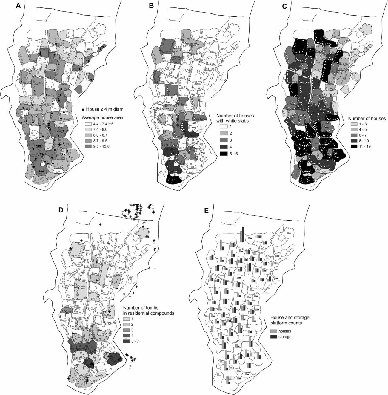
Although surface architecture is quite similar across the site,Footnote 2 it is possible to identify some differences. Unusually large houses are disproportionately clustered in the south-central part of the site (Fig. 5a). Houses that incorporate slabs of white limestone are significantly larger than other houses, and they are more often present in southern compounds and along the central path, both as an absolute and as a proportion (Fig. 5b). As discussed below, southern compounds tend to have more houses, implying larger families, in itself a potential source of inequality (Fig. 5c). Finally, most tombs are found in cemeteries outside the residential area, but those compounds with tombs inside are concentrated in the south-central part of the site (Fig. 5d). One cluster of tombs in the southeastern point of the site is especially remarkable: it includes the only chullpa within the site, and four unusually large and well cut slab-cist tombs.
Possible indices of social difference between compounds, based on surface architecture.

These possible indices of distinctiveness point to the southern part of the site, and to a lesser extent the compounds lining the central path, as possible higher-status areas, in contrast to most of the northern part of the site and the western and eastern peripheries. At the same time, as Figure 5 shows, aside from differences in the presence and kind of tombs, the indices of difference are not tightly concentrated and they are quite patchy within sectors.
Surprisingly, the southern compounds are not necessarily the compounds with the most storage capacity. In general, northern compounds have at least as many storage platforms in absolute terms, and more storage platforms per house (Fig. 5e). (This statement also holds true when capacity is computed as total storage platform area, to correct for differences in storage platform size.) These ratios between storage platform count (or area) and house count are also more consistent in the north, possibly suggesting more autonomous management of storage within northern compounds.
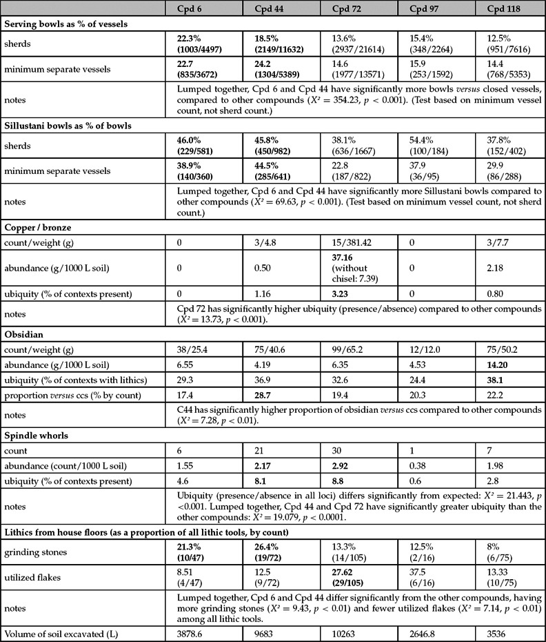
These findings are supplemented by evidence from the excavated compounds. Guided by the surface architecture, we expected Compounds 6 and 44, which are located in the southern third of the site and have several unusually large and well-built houses, to be high-status compounds (Figure 3). We expected Compounds 97 and 118, small compounds in the north with few houses, to be low in status, and Compound 72 to be of intermediate to low status. (Minimal excavations in Compound 59 did not provide enough information for comparison, so they are excluded from this discussion.) However, our excavation data paint a more complicated picture. First, there is great similarity overall across compounds in the domestic equipment present. All have very similar assemblages of ceramics, large numbers of grinding stones and other lithic tools, and spindle whorls, indicating that these separate residential groups participated in a common set of domestic activities. While analysis of the faunal data is ongoing, ample camelid remains in every excavated compound show that livestock was owned (or at least eaten) widely. Langlie's (Reference Langlie2016) research establishes that staple crops are very consistent and were dominated by large amounts of quinoa: families across the site had a similar plant diet.
Nevertheless, there are differences between compounds in the abundance and ubiquity of possible high-value items (summary data are given in Table 1 and will be discussed in greater depth in future publications). The best evidence supporting the interpretation of ‘elite’ status for Compounds 6 and 44 lies in the ceramic assemblage. The ratio of serving bowls (open vessels) to all closed or restricted vessel forms (cooking and storage vessels) is higher in Compounds 6 and 44 than in the other compounds. Compounds 6 and 44 also had higher proportions of decorated Sillustani bowls among their bowl assemblage, especially white-slipped varieties, which may have been an especially prestigious serving ware. Hence, these compounds may have been engaged more in special serving events. However, other artefacts are distributed in ways that do not strongly support the idea that Compounds 6 and 44 were ‘elite’. For example, Compound 72 has by far the most abundant metal (copper and bronze),Footnote 3 and it also has the only secure evidence of metal production recovered in excavations, consisting of a small amount of lead slag. (There is an informal copper mine just at the foot of the site, and it is likely that bronze was produced locally.) Compounds 72 and 118 had the highest abundance of other small ornaments and special finds, such as stone beads, fossils, polished stone nodules and small ceramic figurines, although these items are rare enough that the difference cannot be assessed with confidence. Access to obsidian was probably also limited, given that it must have been procured through long-distance networks: pXRF analysis of 14 samples of obsidian from Ayawiri shows that all derive from the Chivay source in the Colca valley, about 130 km away (N. Tripcevich pers. comm., 2012). Compound 118 had twice or more the abundance of obsidian in LIP levels compared to other compounds, while Compound 44 had the highest ratio of obsidian to other fine-grained flaking rock (cryptocrystalline silicates).
Possible indices of social difference between compounds, based on excavation evidence (secure LIP contexts only). Bold numbers signal values that trend higher.

Differences in the proportion and abundance of tools also indicate somewhat different emphases in occupational activities. Spinning whorls are found on house floors in all compounds, but they are most abundant and ubiquitous in Compounds 72 and 44 (see Table 1). These are also the only two compounds in which ceramic sherds had been repurposed into spindle whorls. While lithic tools are similar across compounds, the proportions vary; among other differences, house floor assemblages in Compounds 6 and 44 include proportionally more grinding stones, while in Compounds 72, 118 and 97 they include more flake tools.
In sum, the southern third of the site can be tentatively identified as a higher-status area. Yet perhaps the more interesting point is that it is so difficult to identify Ayawiri's ‘elites’ with confidence. The southern portion of the site, best represented by Compounds 6 and 44, had special claims to ancestral tombs, contained disproportionate numbers of large houses and special houses with white slabs, and used more fine serving wares. The northern portion of the site had accrued more staple wealth per house as indicated by storage capacity, and individual compounds in the north had access to metal (Compound 72) or obsidian (Compound 118) in amounts that rivalled or exceeded the southern compounds. Thus, it would be hard to argue that the high social rank more evident in the south involved significant wealth advantages. Or perhaps a better statement is that the inter-compound differences expressed at Ayawiri did not align along a single axis of ‘eliteness’. Finally, these differences are almost all clines, or gradations, rather than categorical distinctions. We have not identified any particular type of good, valuable, or structure that is exclusive or sumptuary, diacritically marking off ‘elites’, unless perhaps it was the right to have tombs within the residential compound. And this possible distinction brings us to the issue of ancestry and priority.
Site growth, first settlers and corporate neighbourhoods
Social distinctions at Ayawiri were probably related, at least in part, to priority in colonizing the site. Several lines of evidence indicate that the southern part of the site is the oldest in the LIP. Deeper LIP occupations and distinctly separate architectural phases were apparent in the excavations of the southern Compounds 6 and 44. Compound walls in the south are more heavily lichen-covered, and the largest individual lichen specimens are larger.Footnote 4 If we assume that the number of houses within a given compound was in part a result of the growth of the resident group over a few generations (see Lavallée & Julien Reference Lavallée and Julien1983, 110–14), it becomes significant that the compounds with the most houses are disproportionately found in the south-central part of the site (Fig. 5c). The compounds with the smallest populations of structures are in the far north and on the far west and east edges of the mesa, implying that these peripheral places were settled late. This hypothesis is supported by excavations in Compound 97 on the far eastern edge, showing the compound had unusually low artefact density and was apparently occupied only briefly. Priority in colonizing the site was probably related to other indications of status in south-central compounds. This is the most defensively located part of the site, virtually inaccessible except from the north, so it is not surprising that it would have been preferentially selected by first settlers who were relocating for defence.
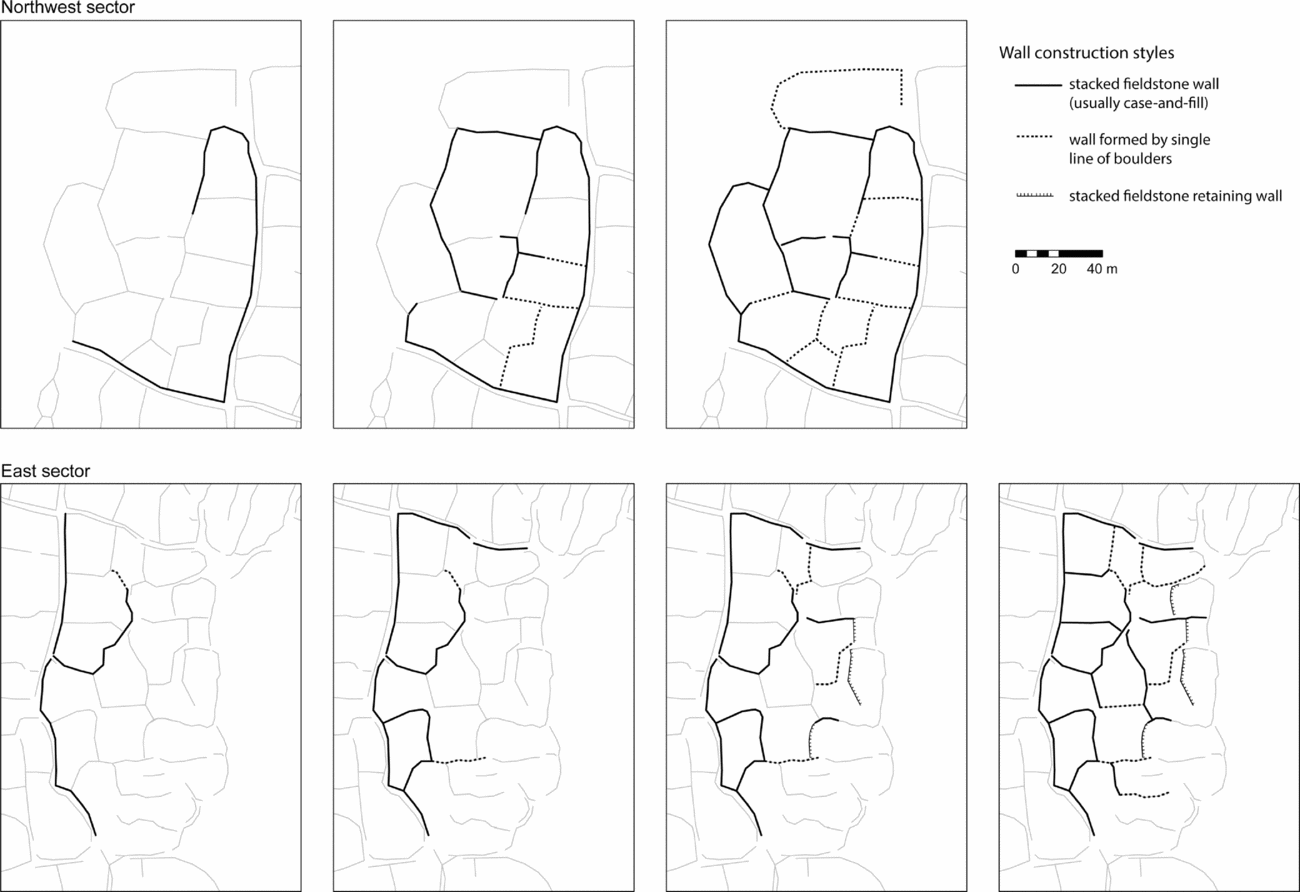
It is equally interesting that the division of the site into sectors was an integral part of the process of site growth. Compound wall abutments shed light on the growth of individual site sectors, although there is too much uncertainty to compile this evidence into an entire site sequence. Figure 6 shows the minimum distinct stages of compound construction in two sectors of the site.Footnote 5 We can identify a basic pattern to these sequences for the central and northern parts of the site. First, long walls were built to cut off large sectors, walls which defined the principal path and intersecting paths. Then, compounds were built inside these sectors, successively budding off from each other. Generally, early compounds in a sector were placed adjoining the long wall of the central causeway, while later compounds were on the edges. Finally, at some point some large compounds were divided, perhaps to separate descendant branches or split off private space for a daughter family. Although these construction sequences appear quite flexible and informal, it is also clear that Ayawiri residents organized themselves into corporate groups whose spaces were defined by walls before being colonized by particular families. In other words, while the site layout can be considered ‘self-organized’, it was organized at a higher level than its constituent compounds, demonstrating the cooperation of larger social groups who can be reasonably imagined as descent groups. These groups claimed or were given large chunks of the mesa-top that they then proceeded to colonize.
Minimum construction stages for the northwest and east sectors of Ayawiri, based on compound wall abutments. The boundary walls defining the sectors and walled paths were some of the first walls built in these portions of the site. Line-of-boulder walls are lower and more expedient than stacked fieldstone walls, and were sometimes used to subdivide large compounds.

When the site was fully colonized, divisions between sectors would have been reinforced by patterns of daily movement and interaction. There were two distinct kinds of circulation at the site: movement on the designated paths that form the site's arteries, and informal passage through neighbours’ compounds in order to get to the public paths. The paths are demarcated by side walls, and in most cases they are elevated by a metre or more of masonry and fill. Small steps give access up to the long central path from the compounds at either side, so using it entailed a physically experienced transition of stepping up and down. But site residents also passed directly from one compound into another through gaps in the compound walls. Because almost half of the residential compounds did not adjoin a path, their residents had to pass through their neighbours’ compounds to go anywhere. Given this fact, the choice to build any formal paths at all at Ayawiri is interesting. I would suggest that these paths, especially the central path, served as much to demarcate site sectors and constrain movement as to facilitate circulation. Dividing the site population into groups larger than the compound, the formal paths created a visibly and bodily experienced social logic of ‘neighbourhoods’, each consisting of about 10–20 domestic compounds. Within a given neighbourhood, people walked through each others’ compounds constantly; in other neighbourhoods, the domestic compounds were places they had no legitimate reason to be. Hence, the simple requirements of movement meant that daily social interaction was far more intense within the neighbourhood than beyond it.
While there are status differences between these distinct groups—evident in the differences between the oldest, southern part of the site and the rest—additional gradients of priority existed within them. The oldest compounds within a sector often sat adjacent to the central path, and the spaces on the far eastern and western edges were occupied last. Residents of some peripheral compounds would have had to pass through several other compounds in order to reach the central paths.
It may be relevant that sub-site corporate groups are also suggested by the fact that Ayawiri's inhabitants used several distinct cemeteries. Excavations conducted by Matthew Velasco show that tombs themselves usually contained multiple burials, including subadults and males and females of varying ages, suggesting that family organization governed the use of mortuary spaces (Velasco & Arkush Reference Velasco and Arkush2012). The mortuary placement of deceased community members seems consistent with the idea that social distinctions of descent, ancestry and kin group were probably more strongly marked at Ayawiri than elite/commoner distinctions or part-time occupational specialization.
Privacy and publicity
Residents at Ayawiri chose particular ways to manage the complications of living in close proximity to many neighbours. In general, these solutions do not appear to have taken the route of greater ritual, economic and political integration. Much daily activity was ‘private’ in the sense that it was segregated into walled residential compounds. Storage structures are all found in residential compounds; there is no centrally pooled storage. Food preparation took place inside compounds, and often inside houses, going by the oven features and associated artefacts. Petroglyphs and carved rocks are almost all located inside compounds. Small-scale offering deposits took place within compounds and often within houses. Our direct evidence is that rituals took place within compounds: while there is plenty of unmodified open space near the walls where gatherings could have occurred, there is no central plaza at Ayawiri and no public architecture at this site.
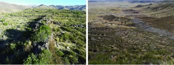
Nevertheless, much of social life would have been public knowledge; little was truly ‘private’ in the sense that it was shielded from others. Not only did neighbours frequently pass through the domestic space of other groups in their neighbourhood, but passers-by on elevated public paths could look down into the compounds to each side, especially those immediately adjoining (Fig. 7). There is, in fact, no practical reason for raising the paths at Ayawiri, beyond improved visibility. Walled paths at most other Titicaca basin hillforts are not raised. However, those hillforts are typically located on hill peaks and flanks on sloping terrain, so that the internal site visibility between domestic terraces is quite good. At Ayawiri, sprawling on a flat mesa with poor internal visibility, raising the street allowed views into domestic compounds that would otherwise have been secluded from public view.
The elevated central path offers views into adjacent compounds (left), while most of the agricultural terraces on Ayawiri's flanks (right) are visible from the site.

Indeed, there is little to suggest that Ayawiri's families wished, or were able, to keep secrets. Stored crops were kept in freestanding external structures that were visible and countable by others. Grinding stones are often found on the surface in the central patio (Fig. 4), so it is probable that some food preparation took place in the open. Tomb locations are marked on the surface, and most of them are located outside the residential sector in the main northern cemetery or in a handful of other cemeteries which are highly visible from the rest of the site, meaning that acts of interring bodies or making offerings to ancestors, if they were not already public events, would immediately have been public knowledge. Finally, terraced fields and water sources are easily visible from various ‘public’ places in the site (Fig. 7). There is no water on site, so the basic daily chore of going to get water and performing other tasks outside the site was fully observable. Ayawiri presents a panopticon-like environment of mutual social monitoring in which many important aspects of family life were exposed to public view, notwithstanding the careful demarcation of domestic space by compound walls. An environment of publicity, knowledge and gossip could have created the conditions for rigid social expectations that enmeshed all members of the community in the social roles expected for their gender, age and kin group. This combination of separation and scrutiny represents a particular way to handle the everyday friction of living in a large community. In an environment of external threat where suspicions could run high, neighbours may have needed to show they were fully committed to ‘our side’.
While these social facts pertained in general across the site, we may note that Ayawiri's residents would have had more knowledge about other families within their same neighbourhood, and that the residents of the oldest southern compounds again held a somewhat privileged position. Their compound walls are somewhat higher. They had to traverse the length of the site to reach the site exits or the northern cemetery, so they would more often have been the observers of other neighbourhoods, and less often the observed. This part of the site must have felt somewhat more private than the rest. And for Compound 6 and those few other compounds that had tombs within the residential compound, interactions with the dead could have taken place away from prying eyes.
Discussion
Around the world, defensive nucleation generated the pressing need to create new kinds of communities. The inhabitants built protection, descent and priority into the architecture of their settlements, making these places far more than defensive ‘containers’ of people. The people of Ayawiri arrived at particular solutions to building a defensive community, and they may offer lessons for thinking about processes of defensive coalescence in general. Let us outline the principles that informed community life—the way people at Ayawiri ‘walked on the right’.
Ayawiri's residents maintained both cohesion and separateness through a combination of principles. There was the careful demarcation of discrete, redundant small residential groups (extended families?) and larger sectors, probably reflecting a logic of descent. There was economic and ritual autonomy of those small residential groups, but also strong norms governing their doings. While archaeologists have sometimes suggested ritual integration as a way to mediate scalar stress (Adler Reference Adler, Lipe and Hegmon1989; Adler & Wilshusen Reference Adler and Wilshusen1990; Bandy Reference Bandy2004), at Ayawiri there is not much evidence for ritual integration at the level of the whole community. Perhaps the ‘need’ for integration was obviated by the defensive interdependence that tied all site residents together in a fortified unit. Instead, we see a pattern of conformity to community norms, which may have been accomplished in part through publicity—the social monitoring afforded by Ayawiri's layout and architecture. Privacy in the sense of self-sufficiency was carefully maintained, while still allowing neighbours to ensure that other kin groups or families, especially the newer arrivals, were behaving in accordance with the expectations of the community and could be counted on to fulfill their defensive responsibilities.
Status and wealth differences at this site are relatively subtle, as they often are at coalescent communities, according to Kowalewski. Nevertheless they were present, and they included—as, probably, at many fortified communities—gradations between more protected and less protected families. In the case of Ayawiri, this and several other status gradations appear to have been related to priority. Compounds in the southern part of the site were not different in kind, but they had more people, slightly nicer domestic architecture, some tombs within the compound, and some special tombs. It is plausible to imagine that these were families of respect and importance. The precedence of the first families at Ayawiri raises interesting general questions about how social inclusion works at defensive communities, questions that cannot be fully answered at this point. Who are considered full members? Who may share fully in public goods? How are rights and responsibilities allocated across a defensive community?
Given the importance of priority, ancestry and descent must have been critically important at Ayawiri, and everything about Ayawiri's architecture suggests that kinship was the central principle by which the site population organized itself. The most salient kin units were the extended family residing within the compound, and the larger corporate kin group within the neighbourhood, groups whose meaningfulness would have been reinforced every day in patterns of movement and interaction within Ayawiri's walls. Yet it is noteworthy that inequality within the neighbourhood could be as pronounced as inequality between neighbourhoods.
Conclusions: defensive communities in the late pre-Columbian Andes and beyond
How, then, does defence shape community? The patterns at Ayawiri represent one particular case of defensive coalescence, not the only outcome; other hillforts, even within the Titicaca Basin, arrived by choice or by chance at somewhat different results. Even geology played a role: flat mesas such as Ayawiri's are only present in the southwestern Titicaca basin, and hillforts farther north and east occupied the crest and adjacent slopes of rounded hills. In those cases, the residential units consisted not of walled compounds, but of wide domestic terraces stepping down the hill flank, affording somewhat different possibilities for site growth, division into sectors and other aspects of spatial organization (Arkush Reference Arkush2011; Frye & de la Vega Reference Frye, de la Vega, Stanish, Cohen and Aldenderfer2005). Visibility within the settlement is often better at these sites, perhaps explaining why their walled streets are not elevated. Moving beyond the Titicaca basin, there is substantial variation in settlement size and in the layout and architecture of large defensive settlements of the Andean highlands (see Guengerich Reference Guengerich2015). Especially interesting are variations in the way privacy and separation may have worked because of architectural choices in different regions (Acuto Reference Acuto, Acuto and Zarankin2008; DeMarrais Reference DeMarrais, D'Altroy and Hastorf2001; Guengerich Reference Guengerich2015; Mantha Reference Mantha2004; Nielsen Reference Nielsen2002). For instance, maze-like access routes that meandered among the high-walled house-patio groups of Xauxa hillfort settlements (DeMarrais Reference DeMarrais, D'Altroy and Hastorf2001) imply close familiarity with the settlement by those navigating it; these sites were not designed for outside visitors, nor did they permit as good knowledge of other site sectors as at Ayawiri, although knowledge might have been diffused ‘by invitation’ when families hosted others in small-scale feasting events. In Chachapoyas hilltop settlements (Guengerich Reference Guengerich2015), house doors were offset to impede visibility and houses carefully kept their walls separate, evincing a fastidious maintenance of a private internal sphere that contrasts with external display in house platforms and friezes. By contrast, in the nucleated towns of the far southern Andes in northwest Argentina (Acuto Reference Acuto, Acuto and Zarankin2008; Leoni & Acuto Reference Leoni, Acuto, Silverman and Isbell2008), elevated walkways and access routes that caused inhabitants to pass through each others’ compounds would have resulted in frequent, fluid interaction and mutual visibility, facilitating homogeneity and conformity even more than at Ayawiri (Acuto Reference Acuto, Acuto and Zarankin2008, 183–4).
Nevertheless, there were many fundamental similarities to large defensive settlements of the Andean highlands in the LIP, suggesting that there may have been a fairly coherent pattern to defensive coalescence in this world region. The biggest defensive settlements of the LIP are quite large sites—in many parts of the central and southern highlands, they are the largest up to that point in the sequence—yet they appear organic and largely unplanned, and usually have little in the way of civic/ceremonial architecture or centralized storage (Arkush Reference Arkush2011; Bauer & Kellett Reference Bauer and Kellett2010; Covey Reference Covey2008; DeMarrais Reference DeMarrais, D'Altroy and Hastorf2001; Frye Reference Frye and Stanish1997; Housse Reference Housse2012; Kohut Reference Kohut2016; Lavallée & Julien Reference Lavallée and Julien1983; Nielsen Reference Nielsen2002; Valdez & Vivanco Reference Valdez and Vivanco1994). Typically they are composed of aggregations of circular single-room houses clumped in patio or terrace groups that presumably corresponded to families (nuclear or extended), resulting in ‘disorganized’ layouts and circuitous access routes. Some large sites are additionally divided in larger sectors implying corporate or ‘segmentary’ organization (e.g. DeMarrais Reference DeMarrais, D'Altroy and Hastorf2001; Frye Reference Frye and Stanish1997; Lavallée & Julien Reference Lavallée and Julien1983, 109). Status and wealth differentiation in architecture and artefacts is usually moderate, and sometimes wholly absent (D'Altroy & Hastorf Reference D'Altroy and Hastorf2001; Guengerich Reference Guengerich2015; Housse Reference Housse2012; Lavallée & Julien Reference Lavallée and Julien1983; Leoni & Acuto Reference Leoni, Acuto, Silverman and Isbell2008; Wernke Reference Wernke2013). The subdued gradients of status that are present may have often been related to founding families and the process of site growth. Lavallée and Julien (Reference Lavallée and Julien1983, 114) consider how the construction and use of defensive hilltop settlements over several generations might have produced the patterns they document in Asto hillforts of southern Ayacucho, where the most central (and best defended) portions of these sites are the most densely occupied, with patio groups containing the most numerous houses, and hence probably the oldest-established families. Larger and nicer houses occupy the higher and more central places in many other large LIP settlements (Arkush Reference Arkush2011; DeMarrais Reference DeMarrais, D'Altroy and Hastorf2001; Guengerich Reference Guengerich2015), suggesting a consistent relationship between founding families, more protected spaces and higher status.
Living in defensive communities must have been a deeply transformative process for late Andean societies of the highlands, in ways that go far beyond the obvious concern with the threat of attack. At the time of colonial Spanish accounts, Andean people of the central and southern highland provinces had fiercely strong connections to corporate lineage ancestors worshipped as mummies, monoliths, or even natural features in the local geography (Isbell Reference Isbell1997; Salomon Reference Salomon and Dillehay1995). They had internal native political hierarchies to varying extents, but this hierarchy was either masked or really constrained (Nielsen Reference Nielsen, Gnecco and Langebaek2014; Platt Reference Platt, Bouysse-Cassagne, Harris, Platt and Cereceda1987) by principles of mutual interdependence and reciprocity, collective control of territory, strong identification and a sense of solidarity and responsibility to the corporate group or ayllu, and a rhetoric of leadership as service and redistribution. Nielsen (Reference Nielsen, Gnecco and Langebaek2014, 105) describes the situation as ‘hierarchies of [lineage] groups, not individuals’. It is worth considering whether the pervasive defensive coalescence in the highlands in late pre-Columbian times may have played a part in shaping patterns of sociality which have traditionally been imagined as quintessentially ‘Andean’ and projected much farther back into the past by archaeologists (Isbell Reference Isbell1995).
If this consideration of defensive communities raises more questions than it answers, that is in keeping with its intent as part of a broader effort by archaeologists to move beyond questions like, ‘is it a fort?’ or ‘was there war here?’ and towards a more holistic understanding of the multiple social realms in which threat and violence operate (e.g. Cameron Reference Cameron2011; Nielsen & Walker Reference Nielsen and Walker2009; VanDerwarker & Wilson Reference VanDerwarker and Wilson2015). To shift the needle on how we think about such sites is to problematize community-making at such places. Building defensive communities posed special problems of crowding, cooperation, trust, the integration of newcomers and options constricted by the threat of violence. The solutions to these problems had long-term social and political ramifications. Defensive architecture and location is only one aspect of defensive settlements—the most obvious one. Behind the walls lay the complicated social realm entailed by defensive nucleation, the norms, institutions and architectures that emerged as large numbers of people packed themselves together in sites like Ayawiri: sites that were social experiments under duress.