Introduction
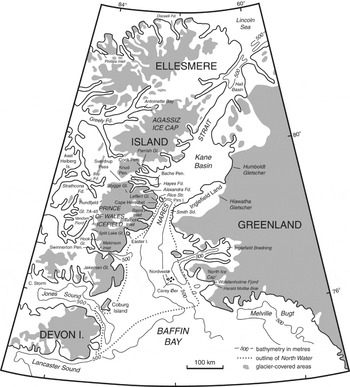
Much of east-central Ellesmere Island, in the Queen Elizabeth Islands, Canadian Arctic archipelago, is covered by the Prince of Wales Icefield. This icefield is the second largest of the ice caps on Ellesmere Island (Fig. 1). Sharp and others (Reference Sharp, Copland, Filbert, Burgess, Williamson and Casey2003), in their report on changes in Arctic glaciers over the 40 year period between 1959 and 1999, noted that the area of the Prince of Wales Icefield had diminished from 20500 km2 to 20337 km2, with a volume change of 63.3 km3 and a mean elevation change of 3.1 m. See also Dowdeswell (Reference Dowdeswell1995), Burgess and Sharp (Reference Burgess and Sharp2004) and Dowdeswell and others (Reference Dowdeswell, Benham, Gorman, Burgess and Sharp2004), for comparative data from the Devon Island Ice Cap, also Burgess and others (Reference Burgess, Sharp, Mair, Dowdeswell and Benham2005, Reference Burgess, Koerner, Demuth, Gray, Short, Cogley, Oerlemans and Tijm-Reijmer2008). The next year Abdalati and others (Reference Abdalati, Krabill, Frederick, Manizade, Martin, Sonntag, Swift, Thomas, Yungel and Koerner2004) reported an area of some 19325 km2. See also Mair and others (Reference Mair, Burgess, Sharp, Marshall, Cawkwell, Dowdeswell, Benham, Oerlemans and Tijm-Reijmer2008). Of all the ice caps on Ellesmere Island the Prince of Wales Icefield is the one which has the most contact with the sea, both the lobate edge of the ice cap itself, especially in the southeast near Easter Island (between Talbot Inlet and Makinson Inlet), and the numerous topographically controlled outlet glaciers, including Leffert Glacier (Figs. 1 and 2). As Koerner (Reference Koerner and Fisher2002) has pointed out, the subglacial bedrock topography plays a major role in the configuration of the Prince of Wales Icefield. The eastward flowing outlet glaciers, of which Leffert Glacier is the northernmost along the coast of Smith Sound, are situated between mountain ridges that are themselves covered wholly, or in part, by ice. On the 1967 edition of Canadian Topographic Map Sheets 39 F and 39E (Ekblaw Glacier, 1:250000; contour interval 500 feet; based on the 1959 aerial photography by the Royal Canadian Air Force) Leffert Glacier can be distinguished as a physiographic entity for at least 55 km westward from its front in Rosse Bay. On the north side of the glacier the mountain wall of gneisses (Frisch Reference Frisch1984, Reference Frisch1988) rises to elevations above 1000 m, whereas on the south side, to the west of ‘Leffert Nunatak’, the mountains are completely inundated by ice and snow. The fluctuations of this major outlet glacier provide a record for much of Holocene time. This paper summarises observations and radiocarbon age determinations on collections made over a period of more than three decades. It complements an earlier paper dealing with Holocene glacier fluctuations in southeastern Ellesmere Island, which included some data from the southern part of the Prince of Wales Icefield (Blake Reference Blake1981a). A selected list of age determinations from sites around the Prince of Wales Icefield was also given in Blake (Reference Blake2005).
Location map, northern Baffin Bay and Nares Strait, Ellesmere Island and Greenland.

LANDSAT image of Smith Sound and the Prince of Wales Icefield, 22 August 1974 (CCRS image E-1760-18010, spectral band 7). The black arrow indicates the position of ‘Leffert Lake I’; the dotted line across Leffert Glacier is 25 km from the terminus.

History of investigations
Observations on the fluctuations of Leffert Glacier are the subject of this report for several reasons. In the first place the northern half of Leffert Glacier (Leffertbræen in the Norwegian of the time) was included in the earliest topographic map, produced in 1898–1899 by Gunnar Isachsen during the period that the second Norwegian Arctic Expedition in Fram wintered nearby (Sverdrup Reference Sverdrup1903; Isachsen Reference Isachsen1907), and it is the only major east coast outlet glacier to appear on this map. Then, Leffert Glacier was included in the topographic map produced by John Wright and Richard Hamilton during a long journey by dog sledge from the advance base of the British Arctic Expedition, 1937–1938, at Etah, North-West Greenland. Although the main emphasis of their mapping, in April and May 1938, was to the south of Leffert Glacier (southward from the ice covered highlands along the north side of Baird Inlet; Figs. 1 and 2), they did add rough contour lines to Leffert Glacier for the first time (Wright Reference Wright1940; see also Wright Reference Wright1997). However, the frontal position of Leffert Glacier is indicated as being essentially the same as on Isachsen's map of 1898–1899.
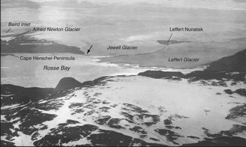
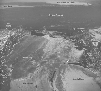
Secondly, the earliest aerial photographs of Ellesmere Island, taken by Jacob Gayer from an open cockpit Loening Amphibian biplane on 8 August 1925 during the MacMillan Arctic Expedition, included an oblique view of Leffert Glacier from a position over Pim Island (Fig. 3; see Byrd Reference Byrd1925, MacMillan Reference MacMillan1925). In this photograph a segment of the tongue of Leffert Glacier has disappeared along the north side, and the terminus has a much more intricate shape than is depicted on Isachsen's map. Also, the moraines along both sides of Jewell Glacier are seen here for the first time, as they are south of the area covered by Isachsen's mapping. Next, when trimetrogon aerial photography was carried out in the Queen Elizabeth Islands in July 1950 by the Royal Canadian Air Force (RCAF), an oblique, eastward view of the fronts of both Leffert Glacier and Jewell Glacier was obtained (Fig. 4), showing that significant retreat had occurred since the earlier mapping. Complete vertical aerial photographic coverage of the area was achieved in 1959, and by that time the terminus of Leffert Glacier was ~1.5 km west of its 1898–1899 position.
Oblique aerial view southwestward across Pim Island toward Leffert and Jewell glaciers by J. Gayer of the MacMillan Arctic Expedition, 8 August 1925. Photograph provided courtesy of the National Geographic Society, Washington, D.C. Note moraine at the front of Jewell Glacier (arrow), which is also indicated in Fig. 4 (from 1950), but which had become an island by the 1970’s. Leffert Glacier extends well seaward of the interlobate moraine leading from ‘Leffert Nunatak’.

Oblique aerial photograph (trimetrogon) eastward over the fronts of Leffert and Jewell glaciers, 15 June 1950; Royal Canadian Air Force, T-399R-162 from 20000 ft. (6096 m). Moraines in front of the north side of Leffert Glacier and at the front of Jewell Glacier are indicated by arrows. Courtesy National Air Photographic Library, Natural Resources Canada.

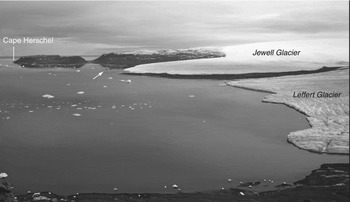
Thirdly, in 1972 Gerald Holdsworth, then with the Inland Waters Branch, Environment Canada, initiated glaciological studies of Leffert Glacier as part of a short lived programme of monitoring calving glaciers and measuring iceberg production in the Canadian high Arctic. His research, largely unpublished, included mass balance observations near the front of Leffert Glacier and on adjacent Jewell Glacier (at that time referred to as ‘Unnamed Glacier’) as well as measurements of motion and ice thickness near the front of Leffert Glacier. The discharge of Leffert Glacier was given as 7×10⁶ m3•a, and the thickness near the terminus was in the order of 60–100 m (Holdsworth and Müller Reference Holdsworth and Müller1976). Koerner (Reference Koerner, Williams and Ferrigno2002) cited an oral communication from Holdsworth as the source for the velocity figure of 40 m • a−1 (winter) that he gives for Leffert Glacier. In addition, tidal observations were made (a maximum range of 4.82 m was recorded at the northern tip of the Cape Herschel peninsula; Holdsworth Reference Holdsworth1977), and soundings were taken of Rosse Bay in front of Leffert Glacier. One of Holdsworth's survey points, at 331 m asl on the north side of Leffert Glacier, close to the terminus, has been used repeatedly by the present author for photography of the glacier front (Fig. 5).
View south from the survey point at 331 m asl near the front of Leffert Glacier, Note the morainic island (white arrow), which was at the glacier edge in 1950 (Fig. 4), in front of Jewell Glacier. W. Blake, Jr. 9 July 2009.

Finally, on 14 April 1973, the third phase of Fritz Müller's ‘North Water Project’ got underway (Müller and others Reference Müller, Ohmura and Braithwaite1974), an outgrowth of his earlier multi-faceted research on Axel Heiberg Island (see Müller Reference Müller and Müller1963, Reference Müller and Fletcher1966). The northernmost of the three meteorological stations that his group established to obtain data on the North Water Polynya was built on the north side of the Cape Herschel Peninsula, facing Rosse Bay, Pim Island and Leffert Glacier, although the original plan was to establish this base at Cairn Pynt on the Greenland side (Fig. 2). The Cape Herschel station was manned continuously between April 1973 and September 1974, was occupied for short summer periods from 1975 to 1979, and the automatic weather stations at this base and in the vicinity (the high plateau at Cape Herschel, northeastern Pim Island and Cape Isabella; Figs. 1 and 2) were maintained until 1980. A stake network was established on the lower reaches of Leffert Glacier and Jewell Glacier, and observations of accumulation and ablation were carried out for several years.
The Geological Survey of Canada's (GSC) ‘Cape Herschel Project’ was initiated by the author in 1977, the primary aims being to work out the glacial history and the pattern of Holocene emergence for east-central Ellesmere Island. Cape Herschel was chosen as a base because: 1) the presence of a well constructed house (plus a wooden out-building and two Parcoll huts), fuel, generators, and workshop facilities made coring (of lakes and ponds) and helicopter operations in the stormy spring weather vastly easier, and there was also a short landing strip suitable, at times, for Twin Otter aircraft; and 2) as a result of his glaciological investigations Koerner (Reference Koerner1977, Reference Koerner1979) had identified this segment of the Ellesmere Island coast as being of particular interest because of the pronounced asymmetry of the adjacent Prince of Wales Icefield, in which the ice on the east side of the ice cap is significantly thicker than that on the west. This difference was attributed by Koerner to the greater accumulation of snow on the east side because of the proximity of open water in Baffin Bay (that is the North Water Polynya), which acted as a moisture source. Koerner (Reference Koerner1977) showed, by radio-echo sounding, that ice depths of >800 m occur along the north-south central ridge of the Prince of Wales Icefield, and that Cadogan Glacier, a major east coast outlet glacier some 60 km to the southwest of Leffert Glacier, is also >800 m thick in places (see also Koerner Reference Koerner, Williams and Ferrigno2002).
The Cape Herschel station was occupied by GSC field parties for part of each spring or summer between 1977 and 1990. In addition, visits were made by the author every three years between 1998 and 2007, and then again in 2009, in conjunction with the continuing limnological and paleolimnological research being carried out by J.P. Smol, M.S.V. Douglas and their graduate students (Douglas and others Reference Douglas, Smol and Blake1994, Reference Douglas, Smol, Blake, Garneau and Alt2000; Smol and Douglas Reference Smol and Douglas2007a, Reference Smol and Douglas2007b).
Materials and methods
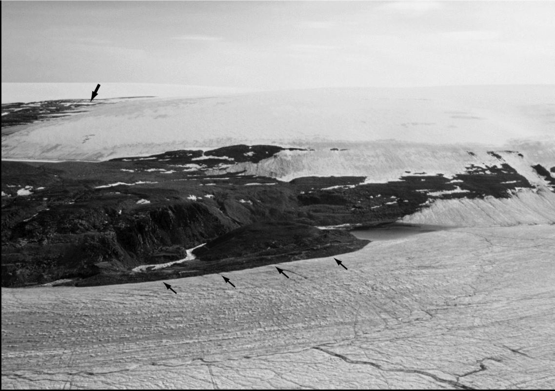
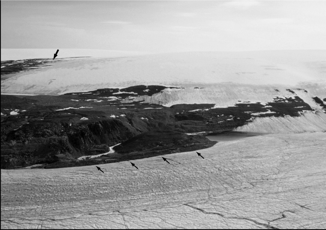
The first site to be visited along Leffert Glacier was an exposed rock knob, informally named ‘Leffert Nunatak’ (Figs. 3 and 6). This feature, situated between Leffert Glacier and a carapace ice dome to the south (part of the Prince of Wales Icefield), is at the up-glacier end of a multi-ridged lateral/medial moraine that extends some 6 km to the sea (Rosse Bay). The ice-cored moraine along the north side of ‘Leffert Nunatak’ was found to contain abundant marine bivalve shells as well as boulders with partial coverings of calcareous algae, also of marine origin. Several collections were made, at elevations between 165 m and 180 m. To the east of ‘Leffert Nunatak’ this moraine merges, in places, with another shell-laden moraine, at the margin of the adjacent Jewell Glacier.
Aerial view southward across Leffert Glacier at ‘Leffert Nunatak’, with lateral moraine composed of shelly till (4 small arrows) and a recently exposed area, completely ice-covered in 1959 when the comprehensive RCAF aerial photography was carried out, of huge lateral drainage channels (heavy arrow). W. Blake, Jr., 20 July 2004.
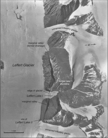
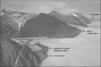
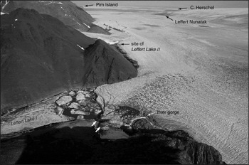
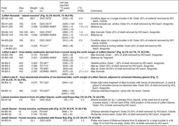
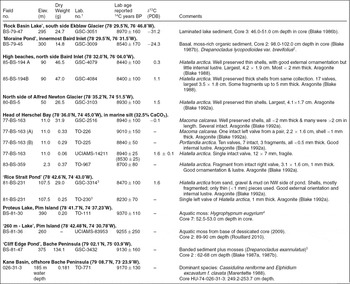
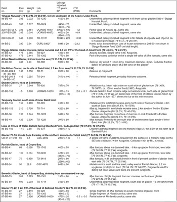
As part of the wide ranging limnological/paleolimnological research, which developed from the author's programme of coring ponds and lakes to gain chronological information (Blake Reference Blake1978, Reference Blake1981b, Reference Blake1982, Reference Blake1987a), a visit was made on 24 June 1983 to an ice-dammed lake (elevation ~405 m by altimetry) in a side valley along the northern margin of Leffert Glacier (Fig. 7). This lake, informally named ‘Leffert Lake I’, is close to 18 km west of the position of the glacier front in Rosse Bay, 19.5 km west of the outermost moraine island, as indicated on the 1967 topographic map (Ekblaw Glacier, 1:250 000; based on the vertical aerial photographs taken by the RCAF on 5 July 1959), and 13 km up-glacier from ‘Leffert Nunatak’. In 1983 the gentle ice ramp leading into the lake was covered, in part, by a veneer of sediment deposited by the ice-marginal river, which debouched from a tunnel at the up-glacier corner of the triangular shaped lake (Figs. 7 to 10). This sediment contained numerous fragments of marine bivalve shells plus a few barnacles, and shell fragments were also found embedded in stringers of sand, gravel and rock debris in the ice of the tunnel walls during pre-thaw visits in succeeding field seasons (see Fig. 2B in Blake Reference Blake1989). Radiocarbon age determinations on several thin shell fragments from the ice-ramp deposits, together with data on shells and calcareous algae from the lateral moraine at ‘Leffert Nunatak’, were published in preliminary reports (Blake Reference Blake1984, Reference Blake1989). Later, a much smaller, ephemeral, ice-dammed marginal lake on the north side of Leffert Glacier, ‘Leffert Lake II’ (Fig. 7), was visited, and marine shell fragments were collected from sediment below a former strandline of this lake at about 385 m asl. The radiocarbon age determinations from these three sites are listed in Table 1, together with age determinations from moraines near the fronts of both Leffert Glacier and Jewell Glacier. In addition, to provide a chronological framework for the early Holocene deglaciation and incursion of the sea, radiocarbon ages from Alfred Newton Glacier and Herschel Bay to the south, and from ‘Rice Strait Pond’, Pim Island and Bache Peninsula/Kane Basin to the north are included (Table 2). Ages on marine pelecypod shells from similar situations along other tidewater glaciers in east-central Ellesmere Island, to provide a comparison with Leffert Glacier, are listed in Table 3. Table 4 provides dating results from pre-Holocene terrestrial deposits on the west side of the Prince of Wales Icefield to compare with the ages of pre-Holocene marine shells in the vicinity of Leffert Glacier. Finally, Table 5 provides a comparison between radiocarbon ages on marine and terrestrial materials from within the same sedimentary unit (see Blake Reference Blake1979), showing that Arctic willow wood (Salix sp.; normalised to a δ13C value of −25.0‰) and Mya truncata shells (normalised to a δ13C value of 0.0‰) yield overlapping ages. Because the GSC radiocarbon age determinations on marine shells were normalised to a δ13C value of 0.0‰, as several leading laboratories working on Arctic materials did at the time (notably Copenhagen and Trondheim), a further correction would not seem to be necessary. See also comments in England and others (2006: 691) with regard to their use of radiocarbon years rather than calendar years.
Vertical aerial photograph of ‘Leffert Lake I’ showing the position of the lobe of Leffert Glacier extending into the lake on 19 June 1952. Note the major drainage valley parallel to, and north of, the northern margin of the glacier, as well as the down-glacier location of ‘Leffert Lake II’. Royal Canadian Air Force, T495 C-72 from 20000 ft (6096 m). Courtesy National Air Photographic Library, Natural Resources Canada.

Aerial view ENE along the northern margin of Leffert Glacier. Note the veneer of sediment on the up-glacier edge of the gently-sloping ramp which extends into ‘Leffert Lake I’. W. Blake, Jr., 24 June 1983.

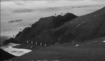
View southwestward at ‘Leffert Lake I’, Leffert Glacier and the mountain ridge covered by the Prince of Wales Icefield. The three notches along the mountain slope plus two notches on the ridge top above the outlet of the ice-marginal river entering the lake from a tunnel are interpreted as indicating former positions of the ice-marginal river. The change in tone on the slope in the foreground represents a former lake shoreline (white arrows), equivalent in elevation to the lowest of the three notches, ~ 45 m above lake level (at ca. 405 m asl) in 1989. W. Blake, Jr., 16 July 2001.

Aerial view eastward along Leffert Glacier, showing the changed state of the lobe entering ‘Leffert Lake I’. Numerous icebergs are floating in the lake, the ice has advanced so as to intersect the opposite shore (as indicated by two heavy white arrows in the foreground), and the river entering the lake from the up-glacier tunnel has incised a gorge several metres deep through the chaotically fractured and sediment-covered ice. A former marginal river channel toward the sea is indicated by two thin white arrows. W. Blake, Jr., 20 July 2004.

Radiocarbon ages from Leffert Glacier and Jewell Glacier

1 GSC Geological Survey of Canada. TO = IsoTrace Laboratory, University of Toronto. Stable isotope ratios from Environmental Isotope Laboratory (EIL) University of Waterloo, were obtained on a portion of the CO2 used for dating at IsoTrace Laboratory. UCIAMS = University of California Irvine Accelerator Mass Spectrometer.
2 BP = before present, where present is taken to be 1950. All original ages except TO-6397, in this table, were reported by both GSC and IsoTrace with a built-in correction of 410 years to δ13C = 0.0‰. Although calibrated ages were produced for most of the 14C ages listed in Table 1 to 3 and 5, here only the ages as reported by the laboratory are listed, and for any age on marine shells that was reported using a base of −25‰, the age corrected to a base of 0.0‰ has also been given. My reluctance to use calibrated ages is because a series of 14C ages on marine shells in two cores taken in northern Baffin Bay have yielded three different sets of calibrated ages in three different reports (compare Blake Reference Blake1998; Levac and others Reference Levac, de Vernal and Blake2001; Knudsen and others, Reference Knudsen, Stabell, Seidenkrantz, Eiríksson and Blake2008), the result of the calibrations being done by different people at different times, using different tables; see also Broecker (Reference Broecker2006) and England and others (Reference England, Atkinson, Bednarski, Dyke, Hodgson and Ó Cofaigh2006).
3 Age determinations published in Blake (Reference Blake1989).
4 Age determinations published in Blake (Reference Blake1998). To make TO-6397 consistent with all other GSC and TO determinations on marine shells listed here, the age given is corrected to δ13C = 0.0‰. All age determinations from the University of California, Irvine (UCIAMS) are normalised to a 13C value of −25.0‰. To make these results comparable to the GSC and TO ages given here, 410 years has to be subtracted from each result (see ages given in parentheses).
5 GSC-4259 is virtually identical in age to GSC-1916, 350 ± 50 14C years BP, on a sample of Astarte borealis collected alive by dredging (on 24 August 1898) in the nearby Rice Strait area; a second sample collected at the same time, of Balanus crenatus (plates), yielded a result of 240 ± 100 years (GSC-2672; Blake Reference Blake1975, Reference Blake1987b). Also, Nucula belloti from a recent (post-1950) push moraine on the north side of Ekblaw Glacier yielded an age of 395 ± 15 14C years (see Table 3).
Radiocarbon ages for the earliest Holocene, south and north of Leffert Glacier

1 See footnotes 1 and 2 to Table 1.
2 Personal communication from J.A. Janssens, 1980, following examination of several moss samples between 98 and 102 cm depth. Note that this age determination, carried out in the GSC's proportional counter, was based on a 4 cm-long core increment. Likewise the previously listed sample, from ‘Rock Basin Lake’, comprises a 5 cm-long increment. Had AMS dating been available, a 0.5 or 1.0 cm-thick slice of sediment could have been used. In both cases older ages undoubtedly would have resulted.
3 Note that a third determination from the ‘Rice Strait Pond’ site, on a single fragment of Balanus sp., yielded a result of 37 980 ± 390 14C years BP (UCIAMS-46866; δ13C = 1.2 ± 0.1). This shows that ‘old’ shells, derived from till or from pockets of pre-Holocene marine sediment, are also present in the vicinity.
4 Personal communication from J.A. Janssens, 1979, following examination of mosses at 49-50 cm depth (base) of BS-79-27 (Core 2) from same lake and same area in lake (unpublished Bryological Reports JJ258,JJ259, JJ286, JJ287 and JJ288).
5 Unpublished Bryological Report 482, by J.A. Janssens, 1982. The same comment made in footnote 2 applies here with regard to AMS dating of a smaller increment.
Radiocarbon ages from other outlet glaciers, east central Ellesmere Island

1 See footnotes 1 and 2 to Table 1. All age determinations from the University of California, Irvine (UCIAMS) are normalized to a δ13C value of -25.0‰. The same is true for TO-3419, TO-6924, TO-6929 and TO-6930. To make these ages comparable to GSC and early IsoTrace (TO) ages, 410 years have to be subtracted, as indicated.
2 CURL is the identifier for INSTAAR's Laboratory for AMS Radiocarbon Preparation and Research, University of Colorado at Boulder.
3 Collected by R.J.H. Richardson; identified by H. Jetté.
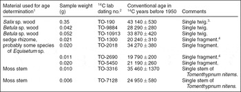
Radiocarbon age determinations on individual organic fragments from a single collection (83-BS-100), Glacier 7 A-45 site, west side of the Prince of Wales Icefield, Ellesmere Island (77°49.8’N, 81°45’W; ~ 140 m a.s.l.)

1 Determinations are as follows: Wood by R.J. Mott, Geological Survey of Canada (unpublished GSC Wood Identification Reports 83-4 & 84-19); wood (Betula), verified by C. Alix, then at Alaska Quaternary Center, Fairbanks, Alaska; sedges (Equisetaceae. . . ‘horsetail family’, unpublished GSC Plant Macrofossil Report 82-4) by J.V. Matthews, Jr., formerly GSC, now Ohana Productions, Hubley, Nova Scotia; mosses by J.A. Janssens, Lambda-Max Ecological Research, Minneapolis, Minnesota (unpublished Bryological Reports 479 and 1025).
2 Laboratory designation: TO = IsoTrace Laboratory, University of Toronto.
3 All material in this collection is from the uppermost organic layer beneath till and stratified sediments. The age was originally reported as 41910 ± 450 14C years (Blake, Reference Blake1988).
4 These two fragments came from the same stem, thus providing a good internal check on the ages.
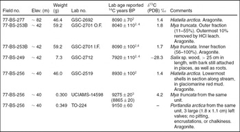
Radiocarbon age determinations, southern Swinnerton Peninsula (77°19.2’N, 82°01’W)1

1 See footnotes 1 and 2 to Table 1.
2 Age determinations published in Blake (Reference Blake1979). A separate, reworked piece of Salix sp. wood (77-BS-252) from this section, within the same massive stony silt unit containing shells (GSC-2701), yielded an age of 41 260 ± 380 years (TO-113); cf. results listed in Table 4 from Glacier 7 A-45, 57.5 km to the north.
3 All age determinations from the University of California, Irvine (UCIAMS) are calibrated to a δ13C value of −25.0‰. To make this age determination, on Mya truncata, comparable to the GSC and TO ages given here, 410 years has to be subtracted; the result is 8865 ± 20 years. This value overlaps with GSC-2519, 8930 ± 100 14C years, on Hiatella arctica from the same unit.
4 As explained in the original paper (Blake Reference Blake1979) the close agreement between terrestrial wood (Salix sp. calibrated to δ13C = −25‰) and marine shells (calibrated to δ13C = 0.0‰) suggests that further corrections to shells may not be necessary (compare Krog and Tauber Reference Krog and Tauber1974; Tauber Reference Tauber, Berger and Suess1979; Bennike and Kelly Reference Bennike and Kelly1987; Mörner and Funder Reference Mörner, Funder and Funder1990; and Rasmussen and Rahbek Reference Rasmussen, Rahbek, Grønow and Pind1996; also see Dyke and others Reference Dyke, McNeely, Southon, Andrews, Clague, England, Gagnon and Baldinger2003; England Reference England1999; England and others Reference England, Dyke and McNeely2003; England and others Reference England, Atkinson, Bednarski, Dyke, Hodgson and Ó Cofaigh2006; Mangerud Reference Mangerud1972; Mangerud and Gulliksen Reference Mangerud and Gulliksen1975; Mangerud and others Reference Mangerud, Bondevik, Gulliksen, Hufthammer and Høisæter2006). The reader is also referred to Table 6 in Blake (Reference Blake1975), which lists comparisons between marine pelecypods, marine gastropods, and both Picea sp. and Salix sp. driftwood (the Salix probably being of local origin) for a site on Bathurst Island, Nunavut. Again there is close agreement between the ages, calibrated as above.
Results and discussion
Radiocarbon age determinations, Leffert Glacier
The first age determinations from the moraine along ‘Leffert Nunatak’ (Fig. 7) were made in the GSC's proportional counters (Blake Reference Blake1984). Then, because 14C dating by accelerator mass spectrometry (AMS) had become feasible by the late 1970’s, the final dating in the original series from the moraine, as well as all determinations on individual shell fragments from the ice dammed lakes, were carried out at the IsoTrace AMS facility at the University of Toronto (Tables 1, 2 and 3). More recently additional 14C age determinations on individual shell fragments from both ‘Leffert Nunatak’ and ‘Leffert Lake I’ have been obtained from the AMS laboratory at the University of California, Irvine. These results show that the front of Leffert Glacier was an unknown distance west of ‘Leffert Lake I’ for over 2000 14C years, or close to 4000 14C years if the two ages from ‘Leffert Lake II’ are taken into account. The youngest dated shell fragment from ‘Leffert Lake I’ is 2390 ± 70 14C years old (TO-387), whereas the ages of the youngest shells from the moraine at ‘Leffert Nunatak’, are 2280 ± 140 14C years (GSC-3515) and 2260 ± 15 14C years (UCIAMS-46867). The latter result becomes 1850 ± 15 14C years when normalised to a δ13C value of 0.0‰ to make it compatible with the GSC results and the early results from IsoTrace. This age places a limit on the time of Leffert Glacier's latest readvance of ca. 1850 14C years ago, or as recently as 1540 to 1405 calendar years, close to the ages of shells in the medial moraine below Stygge Nunatak (compare Table 3; Blake and others Reference Blake, Douglas, Uutala, Smol and Janssens1993, Reference Blake, Douglas, Smol and Janssens1997), 62 km due west of ‘Leffert Lake I’ (Figs. 2, 11, and 12).
Aerial view westward at ‘Stygge Nunatak’, Stygge Glacier, and nearby unnamed glaciers debouching into Jokel Fiord. W. Blake, Jr. 27 May 1984.

Aerial view northeastward across ‘Stygge Nunatak’ toward the front of the adjacent glacier (unnamed) in Jokel Fiord (outlined by small arrows) some 6 km distant. The 1984 coring site in ‘Stygge Nunatak Pond’ is outlined by a circle. Sites in the col in the foreground, on the slope east of the pond and in the medial moraine below the nunatak from which marine shells were collected, are indicated (see Table 3). W. Blake, Jr. 27 May 1984.

The procedure of dating a single shell or shell fragment eliminates the possibility of mixing Holocene-aged shell material with the pre-Holocene shells that are also widespread in glacial deposits in the area (Blake Reference Blake1977a, Reference Blake1985, Reference Blake1986a, Reference Blake1992a, Reference Blake1992b, Reference Blake1993; England Reference England1998, Reference England1999; England and others Reference England, Smith and Evans2000, Reference England, Atkinson, Dyke, Evans and Zreda2004). Ice streams and valley glaciers moving down fiords, straits or across other water bodies and then impinging on land have invariably ploughed up marine shells and bottom sediment and plastered these materials onto the adjacent land masses, as noted first in the field area by Christie (Reference Christie1962, Reference Christie1967). For example, individual shell fragments of Astarte borealis and Mya truncata from the southern sector of the massive moraine fronting Jewell Glacier (Fig. 4), at ca. 90 m asl, have yielded ages of 31660 ± 270 (TO-924) and 42950 ± 740 14C years BP (TO-4245), respectively. Other examples, in addition to those on top of Cape Herschel (Blake Reference Blake1977a, Reference Blake1992b, Reference Blake1999), can be found at ‘Stygge Nunatak’ (Figs. 2 and 12) where single Astarte sp. fragments in till some 340 m asl have yielded ages of 19390 ± 220 14C years BP (TO‑1311) and 30620 ± 180 14C years BP (UCIAMS-46871). Also, at ‘Rice Strait Pond’ (Fig. 4), close to the front of Leffert Glacier, where abundant Holocene thin-walled bivalve shells occur (Blake Reference Blake1992a, Reference Blake1993; Table 2), a Balanus sp. fragment yielded an age of 37980 ± 390 14C years (UCIAMS-46866). These five age determinations on shells in till span a period of close to 20000 14C years. Support for the concept of ice free conditions over such a considerable period of time comes from a site on the west side of the Prince of Wales Icefield, adjacent to Glacier 7 A-45 (Fig. 1). There, determinations on individual pieces of wood, sedges and mosses range in age from 19790 ± 300 14C years (TO-2690) to 43140 ± 530 14C years (TO-190), as listed in Table 4 (see also Blake Reference Blake1992b, Reference Blake1996, Reference Blake1999; England and others Reference England, Smith and Evans2000). Of these age determinations on both marine shells and terrestrial organic materials, it is the youngest ones, in the 19000 to 20000 14C year age range, that provide a limiting date for the inception of the latest Wisconsinan glaciation.
‘Leffert Lakes I and II’
Perhaps the most interesting site along Leffert Glacier is the upper, ice-dammed lake, ‘Leffert Lake I’. Not only were marine shell fragments found in the sediment on the ice ramp, as well as fragments of wood and a dessicated ermine (not dated; identified by C.R. Harington, Canadian Museum of Nature, Ottawa), but strandlines around the lake basin indicate higher stands of water in the past. Also, when viewed from the opposite side of the lake, the mountain slope above the tunnel entering ‘Leffert Lake I’ can be seen to have three prominent notches (Fig. 9). These notches are interpreted as representing former positions of the ice marginal river that flows into the lake today, a river which alternates between tunnels in the ice and flow directly against the rock wall. The summit of the ridge above the southwest corner of the lake is at roughly 735 m asl, some 330 m above lake level as it was in the 1980’s. The lowest of the three notches was 45 m (by altimetry) above lake level in 1989, and the other two notches are estimated to be roughly 75 m and 150 m higher, respectively, so the three channels would thus be at approximate elevations of 450 m, 525 m, and 600 m.
One well preserved strandline around ‘Leffert Lake I’, which corresponds in elevation to the lowest of the three notches, is assumed to have formed relatively recently, perhaps when Leffert Glacier was at the advanced position recorded in 1898–1899 or possibly also in 1925 or 1938; that is, when the terminus was well east of the position it occupied in 1950. The two higher notches, for which no corresponding strandlines were noted, probably relate to the waning stages of ice earlier in Holocene time, perhaps as early as the time when Leffert Glacier was still connected to southward flowing ice moving from Rice Strait towards Elison Pass (Fig. 4). The same is true, as is shown in Fig. 9, for two additional notches that have been cut into the ridge crest where it rises to the west. These features presumably represent other, even earlier, phases of marginal river activity, when Leffert Glacier was considerably thicker than it is now. An east-west oriented dry valley, also interpreted as having been formed when the ice was thicker, is present on the mountain slope above and immediately to the west of Leffert Lake I, as well as eastward toward the sea from this lake (see Figs. 7, 9, and 10). In addition, lateral drainage channels exposed at the thin, feather edge of the carapace ice on the plateau between Jewell Glacier and Alfred Newton Glacier, as well as deep meltwater channels being exposed at present on the slope above, and south of, ‘Leffert Nunatak’ (Fig. 6), attest to the drainage of massive amounts of water eastward at much higher elevations than at present. When this occurred an enlarged Leffert Glacier probably extended southward through Elison Pass toward Herschel Bay, between the Cape Herschel Peninsula and the mainland of Johan Peninsula.
In contrast to ‘Leffert Lake I’, the much smaller and ephemeral ‘Leffert Lake II’ does not occupy a side valley, but is a narrow, east-west oriented lake along the glacier margin, at the junction of Leffert Glacier with an unnamed tributary glacier flowing from the upland ice cap to the north (Fig. 7). ‘Leffert Lake II’ drains periodically via a deeply incised river which develops at the junction between Leffert Glacier and the unnamed tributary glacier.
When ‘Leffert Lake I’ was revisited in 2004, it was found that the glacier had advanced into the lake, impinging on the opposite shore at one point (Fig. 10). The surface of the gently sloping, sediment covered ice ramp in front of the tunnel was disrupted into an extremely rough and crevassed surface, and the river now enters the lake via a gorge cut into this chaotic ice. A number of icebergs were floating in the lake as well. This minor readvance has taken place during the same period of time that the terminus of Leffert Glacier has continued to recede, albeit slowly.
Radiocarbon age determinations, other outlet glaciers
As a result of the discovery of transported marine shells along Leffert Glacier, a reconnaissance was made of the margins of other tidewater outlet glaciers draining the northern part of the Prince of Wales Icefield. These are Stygge, Alfred Newton, MacMillan, Ekblaw and Tanquary (Figs. 1 and 2). In addition, an unnamed expanded-foot glacier (7E-22), which dams the valley (and a lake) between Beitstad Glacier and the head of Beitstad Fiord (3 km to the northeast), was visited, and marine bivalves were sampled from the sediment pushed up in a frontal moraine as this glacier has advanced recently. Still further north the surface and margins of Benedict Glacier, a glacier draining to Sawyer Bay from the unnamed ice cap in the mountains to the north of Sverdrup Pass (Figs. 1 and 2) were investigated, as were the margins of Parrish Glacier, the southernmost tidewater glacier from the Agassiz Ice Cap. Age determinations for all of these sites are listed in Table 3.
Stygge Glacier, at the head of the Jokel Fiord/Hayes Fiord system, is unusual in that a mountain protrudes between this glacier and an adjacent unnamed outlet glacier some 5 km from the terminus of the latter in Jokel Fiord, as delineated on the 1:250000 Ekblaw Glacier map sheet (see Figs. 11 and 12). The southern peak, which is the highest at ~515 m, is made up of orthopyroxene granite, as is the bulk of the nunatak; the northern peak, however, which rises to ~400 m asl, has a cap of Palæozoic limestone (Frisch Reference Frisch1984, Reference Frisch1988). Both peaks exhibit clear evidence of overriding by ice – striae, grooves and erratic boulders. The intervening valley contains a subsaline pond, which has been the subject of considerable study (Blake and others Reference Blake, Douglas, Uutala, Smol and Janssens1993, Reference Blake, Douglas, Smol and Janssens1997; Paul Reference Paul2008; Paul and others Reference Paul, Douglas and Smol2010). Fragments of marine bivalve shells have been collected in the col ‘up-glacier’ (west) from the pond and from till overlying sculptured granite bedrock on the slope above the eastern end of the pond. As well, intact bivalve shells have been collected from the medial moraine below (northeast of) the nunatak, as summarised in Table 3. The differences in age between shells at the three sites suggests that several phases of retreat and readvance of Stygge Glacier and the unnamed glaciers nearby have occurred.
The single shell dated from above the eastern, down-glacier side of ‘Stygge Nunatak’, in till above the former pond outlet (in which striated bedrock is also exposed), yielded an age of 19340 ± 220 14C years (TO-1311). If this age is accepted at face value, it derives from a time, replicated at several other sites (Table 4) and immediately prior to the Late Wisconsinan build-up of ice, when Jokel Fiord extended an unknown distance to the west and southwest of the nunatak, which may well have been an island; see Benham and Dowdeswell (Reference Benham and Dowdeswell2003) for April 2000 radio-echo sounding data from the unnamed outlet glacier (from the Prince of Wales Icefield), which abuts Stygge Glacier to the east, both above and below the nunatak.
The till in the col facing west toward the upper reaches of the present day Stygge Glacier, at the opposite end of ‘Stygge Nunatak Pond’ from the site just described, yielded numerous tiny shell fragments; four have been dated, as listed in Table 3. One yielded an age of 30620 ± 180 14C years (UCIAMS-46871), but the other three were similar to one another: 4560 ± 10 (TO-1230), 4040 ± 70 (TO-6929) and 4240 ± 20 14C years (UCIAMS-46872), the latter two results converted to a δ13C value of 0.0‰. These three results indicate that innermost Jokel Fiord was open water by mid-Holocene time, and the build-up of ice that followed was powerful enough to carry marine shells upward more than 350 m, onto the western side of the mountain which is now ‘Stygge Nunatak’. Unlike the advance at the beginning of the Late Wisconsinan build up of ice, the mid-Holocene readvance apparently did not reach, or push across, the actual basin now occupied by ‘Stygge Nunatak Pond’, as the diatom stratigraphy in the permanently frozen ice encountered in coring the pond suggests that the ice has formed in situ as ‘intrasedimental segregation ice’ (Paul Reference Paul2008; Paul and others Reference Paul, Douglas and Smol2010) and is neither lake ice nor a remnant of glacier ice. Finally, the two individually dated pelecypod shells from the medial moraine down-glacier from ‘Stygge Nunatak’ yielded ages of 1850 ± 50 (TO-927) and 1770 ± 50 (TO-1302) 14C years BP, documenting a more recent and less extensive fluctuation of the glacier termini.
The most interesting, and in the author's view, unexpected, 14C-result from ‘Stygge Nunatak’ is one of 9345 ± 10 14C years (CURL-9362), obtained on humic acids at 298–301 cm depth in the longest core (84-BS-2; total length, 387 cm) of frozen sediments recovered by the author and colleagues from ‘Stygge Nunatak Pond’ in three seasons of coring (1981, 1982 and 1984). This result is of particular interest in that it is older than any other radiocarbon age from what was once the interior of the Prince of Wales Icefield, and it is close to the age of basal lake bottom moss at 52.5 to 53.0 cm depth (9390 ± 110 14C years; TO-111; Blake Reference Blake1987a) in Proteus Lake at 390 m asl on Pim Island, 90 km to the east on the coast of Smith Sound (Figs. 1 and 2). Another similar age of 9255 ± 25 14C years (UCIAMS-83953) on moss fragments in ‘260-m lake’ (unofficial name), also on Pim Island, is listed in Table 2 (see Rouillard Reference Rouillard2010). These lake bottom ages are supported by cosmogenic 36Cl ages on erratic boulders from Pim Island (Zreda and others Reference Zreda, England, Phillips, Elmore and Sharma1999). Assuming that the 9345 14C-year age from ‘Stygge Nunatak’ is correct, and it is worth noting that an age of 5510 ± 15 14C years (CURL-9370; Paul Reference Paul2008; Paul and others Reference Paul, Douglas and Smol2010) on humic acids at 44–45 cm depth in the same core overlaps with the age of 5440 ± 80 14C years (TO-3429) on washed-in terrestrial mosses at 43.5–45.0 cm depth (Blake and others Reference Blake1993, Reference Blake, Douglas, Smol and Janssens1997), this result indicates rapid thinning and drawdown of ice in early Holocene time at the head of the longest (~100 km) fiord system on the east-central coast of Ellesmere Island. Perhaps the very presence of the fiord provided a mechanism for rapid drawdown, by enhancing flow once the deglacial process had started.
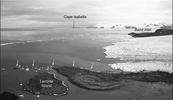
Immediately to the south of Leffert Glacier and Jewell Glacier is Alfred Newton Glacier, which commenced surging in 1981 (see Figs. 13 and 14; also Fig. 5 in Blake Reference Blake1992a). Well preserved Hiatella arctica shells at ~50 m asl and 0.5 km west of the front of the ice edge delta in the 1972 aerial photographs (see Fig. 12 in Blake Reference Blake1981a), yielded an age of 8930 ± 100 14C years BP (GSC-3103, Table 2). Some 5.5 km from the sea, along the north side, a willow twig in a dirt cone on the glacier yielded an age of 5930 ± 80 14C years (TO-388). These results show that the ice had receded and/or thinned significantly in early to mid-Holocene time. Westward of Alfred Newton Glacier, and debouching into the mouth of Baird Inlet, is MacMillan Glacier (Fig. 2). A bulk sample of Hiatella arctica shells, collected along its northern margin at 145 m asl and some 5 km from the terminus, yielded an age of 25700 ± 890 14C years (GSC-3897), but AMS dating of individual fragments of Balanus balanus and Macoma calcarea from the same site gave ages of 7640 ± 60 14C years (TO-71) and 7670 ± 100 14C years (TO-244), respectively (Blake Reference Blake1985, Reference Blake1986 a). For shells of Holocene age to occur now at least 70 m higher than they must have been when the organisms were alive, judging from the pattern of emergence at Cape Herschel (Blake Reference Blake1992a, Reference Blake1993) and the fact that shells in a raised beach at 90 m asl just west of MacMillan Glacier yielded ages of 8440 ± 100 14C years (GSC-4079) and 8400 ± 100 14C years (GSC-4084; Blake Reference Blake1988), shows that a significant basin exists beneath MacMillan Glacier.
View southwestward from the Cape Herschel plateau at the terminus of Alfred Newton Glacier before surging commenced. W. Blake, Jr., GSC-174120. 21 July 1977.
View southward along the coast of Smith Sound at the terminus of Alfred Newton Glacier from photo point, showing new moraines created (white arrows), since 1981, by the pushing-up of shallow-water sediments. W. Blake, Jr., 19 July 2004. The glacier front has retreated close to half a kilometre from the maximum achieved about 1984.

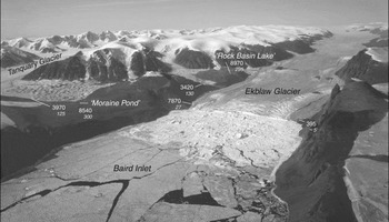
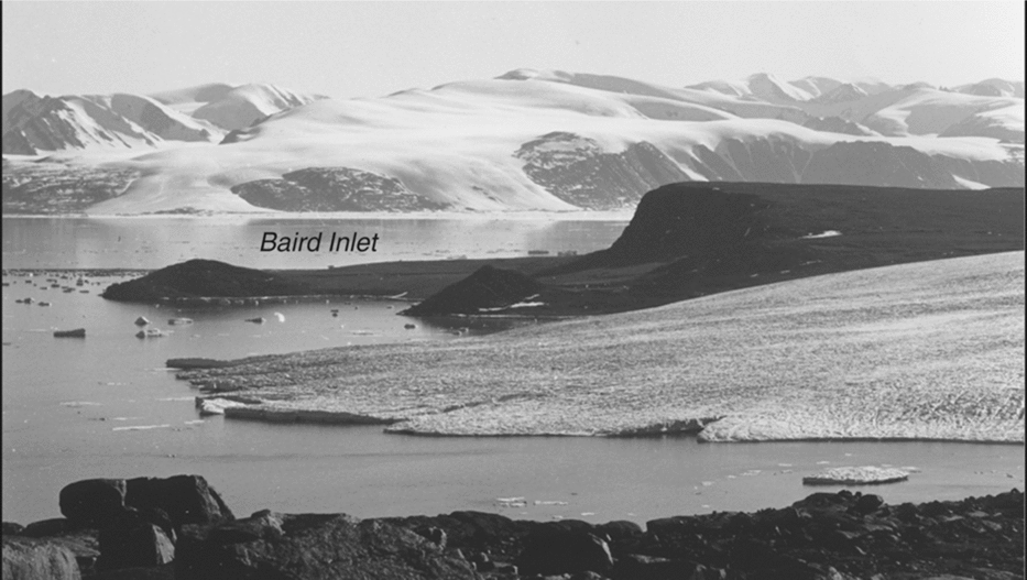
Ekblaw Glacier, at the head of Baird Inlet, is one of the outlet glaciers for which annual velocity fields have been quantified from speckle tracking by Short and Gray (Reference Short and Gray2005). For the year 2003 the width of Ekblaw Glacier at the terminus is given as 2.1 km, the centreline thickness there is 400 m, and the mean velocity at the terminus between 15 February and 11 March of that year was 350 m • a−1 (possibly underestimated by <30 m • a−1 owing to the tidal effect), even more rapid between 24 November and 18 December 2000. These velocities far exceed anything recorded for Leffert, Benedict or Parrish glaciers, and this activity is reflected in the broad belt (over a kilometre in length) of calved icebergs and bergy bits which characterises the innermost part of Baird Inlet (Figs. 15, 16). Short and Gray (Reference Short and Gray2005) further note that there was no change in the position of the terminus between 2000 and 2003, and the calving rate is estimated to be 0.29 ± 0.07 km3•a−1. However, between 1950, when the first set of aerial photographs was taken, and 1988, when an oblique aerial photograph (Fig. 16) was taken by the author, the terminus of Ekblaw Glacier advanced some 700 to 800 m. Thus the situation here is unlike Devon Island, where the major, east- flowing tidewater glaciers are reported to have retreated up to 1.3 km in the 40 year interval between 1959/1960 and 1999/2000 (Burgess and Sharp Reference Burgess and Sharp2004; see also Dowdeswell and others Reference Dowdeswell, Benham, Gorman, Burgess and Sharp2004). Hiatella arctica shells roughly 100 m behind the front (on 20 August 1987) of Ekblaw Glacier, along its southern side, yielded an age of 7870 ± 70 14C years (TO-926, Table 3), providing evidence that the terminus was further to the west in early Holocene time. ‘Rock Basin Lake’, situated at 295 m asl within a rock boss some 3 km west of the terminus of Ekblaw Glacier as it appeared on the 1967 topographic map (39 F & 39E, Ekblaw Glacier, 1:250000), and nearly 4 km west of the front of Ekblaw Glacier today, yielded an age of 8970 ± 160 14C years (GSC-3051) for the basal 5 cm of laminated sediments (Blake Reference Blake1981a, Reference Blake1986b, Reference Blake1987a; Hyvärinen and Blake Reference Hyvärinen and Blake1981; Smol Reference Smol1983; Hyvärinen Reference Hyvärinen1985). These ages are reinforced by dated basal moss-rich organic sediments 8540 ± 170 14C years old (GSC-3009) in a pond within a lateral moraine formed earlier by Ekblaw Glacier at an elevation of 300 m and roughly 5 km to the east of ‘Rock Basin Lake’ (see Figs. 15 and 16, plus Table 3). However, the necessity of using 5–6 cm thick increments for dating in a conventional counter means that the ages obtained for both sites represent minimum values for the time of deglaciation.
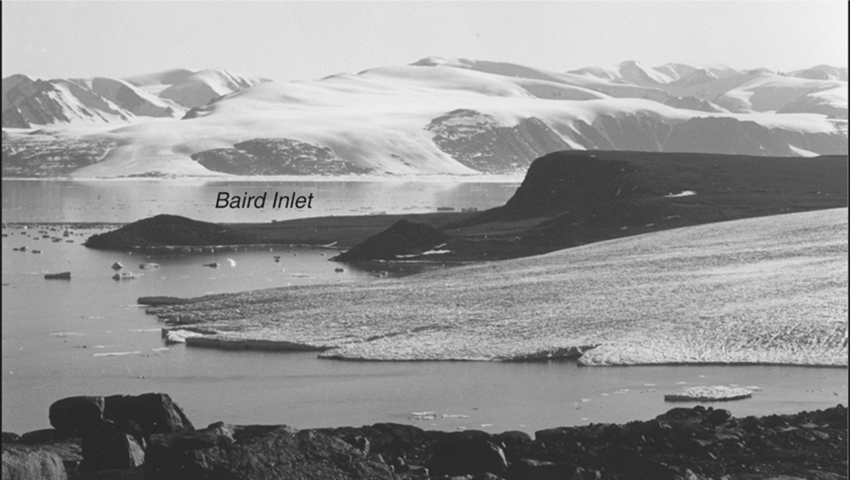
Oblique aerial photograph (trimetrogon) eastward over Baird Inlet, showing the front of Ekblaw Glacier as well as much of Tanquary Glacier. Numbers give ages, in radiocarbon years, of collections at the sites indicated; all are on marine shells except the 8540 number in centre, a basal sediment age from ‘Moraine Pond’. Numbers in italics give elevations (m) for collection sites. The dashed line east of the glacier front shows the approximate position of the terminus in July 1988 when Figure 16 was taken. Royal Canadian Air Force, T4O3R-59 from 20000 ft. (6096 m), 24 June 1950. Courtesy National Air Photographic Library, Natural Resources Canada.

Aerial view southwestward at the actively calving Ekblaw Glacier and innermost Baird Inlet, with coring sites indicated. Radiocarbon ages and elevations as in Fig. 15, plus ‘Rock Basin Lake’. W. Blake, Jr., GSC-204621E. 31 July 1988.

On the opposite side of the glacier terminus a single valve of Nucula belloti in a fresh, metre-high moraine ridge on bedrock, deposited by an advance of Ekblaw Glacier since the 1950 trimetrogon aerial photographs were taken (see Fig. 15), yielded an age of 805 ± 15 14C years (UCIAMS-14210). This result becomes 395 ± 15 14C years when normalised to a base of 0.0‰ to make it compatible with GSC and early IsoTrace age determinations. This age is close to that obtained on living Astarte borealis (380 ± 50 14C years; GSC-1916) dredged from Rice Strait by the second Norwegian Expedition in Fram in August 1898 (Blake Reference Blake1975, Reference Blake1987b), as well as to the age of shells (370 ± 80 14C years BP (GSC-4259; Table 1) obtained from a frontal moraine on the east side of Jewell Glacier.
The lateral moraine along the northern margin of Tanquary Glacier, a major outlet glacier on the south side of Baird Inlet, yielded bivalve shells at both sites visited. A third site was in morainal debris at the junction between the same lobe of Tanquary Glacier and an unnamed outlet glacier immediately to the west, and a fourth site was in outwash derived from both glaciers, and above Ekblaw Glacier (Figs. 15 and 16). On Wright's (Reference Wright1940) map from 1938 this unnamed glacier is shown as a tributary joining Ekblaw Glacier! Ages ranged from 3420 ± 50 14C years BP (TO-1228) to 7430 ± 80 14C years BP (TO-389), indicating that for at least 4000 14C years an embayment of the sea occupied parts of the area now covered by Tanquary Glacier (see Table 3). This embayment may have extended inland as much as 17 km from the position of the terminus as it appears on the 1:250000 topographic map sheet (39 F & 39E, Ekblaw Glacier, 1967; based on the 1959 RCAF aerial photography).
Some 35 km south of the front of Tanquary Glacier and 3.5 km southwest of Stanfield Point (Fig. 2), on the south side of Cadogan Inlet a large moraine has been built at the eastern edge of a lobe of the Prince of Wales Icefield (Glacier 7J-14). A valve of Chlamys islandica in this moraine gave an age of 3460 ± 110 14C years BP (TO-531; Blake Reference Blake1998). Close to 30 km further to the south, at 60 m asl in a large moraine of tidewater Glacier 7 K-59 near Cape Faraday (Fig. 2), a single valve of Astarte borealis collected in 1961 by R.L. Christie yielded an age of 2370 ± 140 14C years (GSC-2699; see Fig. 13 in Blake Reference Blake1981a), a nearly identical result to the youngest dated marine fauna from the sediments at ‘Leffert Lake I’.
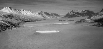
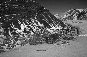
Parrish Glacier, some 20 km in length, is the southernmost outlet glacier from the Agassiz Ice Cap (Fig. 1). According to Williamson and others (Reference Williamson, Sharp, Dowdeswell and Benham2008), the centre line thickness in 2000 at its terminus was 175 m and at that point its surface velocity varied between 24 and 77 m • a−1 for various July to July intervals (1 or 2 years each, between 1999 and 2003). Some 2.5 km north of Parrish Glacier's terminus in Copes Bay, as measured on the Sawyer Bay map sheet (39G; 1:250 000, 1967, based on the 1959 aerial photography), a river enters from the east side, and Hiatella arctica shells 6490 ± 90 14C years old (GSC‑4876) are present in silt and fine sand overlain successively by till and coarse gravel in a now truncated delta at ~50 m asl (Blake Reference Blake1995). Further north there is a large ice-dammed lake (at approximately 73 m asl) on the west side of Parrish Glacier that is up to 4 km in length and 1.5 km in maximum width (Figs. 17 and 18). Aerial photographs show that this lake, informally named ‘Parrish Lake’, was considerably deeper in both 1959 and 1975 than it was at the time of our visit in 1989. Likewise the terminus of Parrish Glacier in May 1989 was ~2 km behind (north of) its position in August 1975. Bivalve shell fragments were found at the northeast corner of ‘Parrish Lake’, some 8 km north-northwest of the glacier terminus on the abovementioned map sheet, and ages of 4600 ± 70 14C years (TO-1742) and 3870 ± 70 14C years (TO-6930; both in Table 3) were obtained. The remaining sample, a fragment of Mya truncata in till on a bedrock bench (75 m asl) south of the 1989 position of the glacier front, yielded an age of 2560 ± 60 14C years (TO-3419). Thus, the front of this major outlet glacier, like Leffert Glacier, was behind its present position for some 4000 14C years, from 6500 to 2500 14C years BP. In this connection it is of interest to note that Lake Tuborg, created when an unnamed glacier on the north side of Agassiz Ice Cap advanced and dammed the head of Antoinette Bay (Fig. 1), came into being approximately 3000 14C years BP (Hattersley-Smith and Serson Reference Hattersley–Smith and Serson1964; Long Reference Long1967; Hattersley-Smith Reference Hattersley–Smith1969).
Aerial view northwestward towards the front of Parrish Glacier, at the head of Copes Bay. The site of marine pelecypods in till is indicated (with age and elevation as in Figs. 15 & 16), together with the up-glacier location in a tributary valley (black arrow) of the large ice dammed lake, informally named ‘Parrish Lake’ (Table 3). W. Blake, Jr., 29 May 1989.

Aerial view northward across the northeastern corner of ‘Parrish Lake’ (~73 m asl) at Parrish Glacier. Marine pelecypod shells over 4000 14C years old (Table 3) are present in the delta, as indicated by the white arrow. Note two groups of morainic hillocks (black and white arrows, circled in white) formed when Parrish Glacier formerly pushed further westward into the ice-dammed lake, some 8 km up-glacier from its terminus in Copes Bay. This morainic topography and the delta were submerged when RCAF aerial photographs were taken from 10 000 ft (3048 m) on 7 August 1975. W. Blake, Jr., 29 May 1989.

One other feature of Copes Bay deserves mention. Some 25 km to the southeast of the 1959 frontal position of Parrish Glacier, where Copes Bay widens to the south, a curved pattern in the sea ice and stranded icebergs on certain aerial photographs indicate the presence of a submerged moraine, like those described from Coburg Island and southeastern Ellesmere Island (Blake Reference Blake1977b, Reference Blake1995), and in the exact position at which a moraine should occur, according to Mercer's (Reference Mercer1961) classic study of Alaskan fiords. It seems likely that this moraine (water depths of 33–38 m versus >100 m in the narrower part of the bay to the north (Canadian Hydrographic Field Sheet No. 3882, 1975)) formed during a pause and/or readvance during general retreat prior to 6500 14C years ago, as no evidence was seen, in terms of remnants of lateral moraines at low elevations along the sides of Copes Bay, that the submerged feature formed during the readvance since 3000 14C years BP.
The two bivalve shell samples from Benedict Glacier were both collected from morainal debris on the glacier, as indicated in Table 3. This glacier, designated by Williamson and others (Reference Williamson, Sharp, Dowdeswell and Benham2008) as ‘Sawyer Bay glacier’, was reported to be 60 m thick at the centre line of the terminus (in 2000), with a surface velocity of 42 m • a−1 (10 July 1999 to 4 July 2003). The dating results show that 3400 to 3500 14C years ago, the front of this outlet glacier from an unnamed ice cap was more than 6 km west of the position indicated in the 1959 aerial photography (see 1:250000 map sheet 39G, Sawyer Bay, 1967). Both Benedict and Parrish glaciers exhibit morainal features which suggest that they have surged in the past (Copland and others Reference Copland, Sharp and Dowdeswell2003).
The third site on this map sheet, Glacier 7E-22, is an expanded foot glacier some 3 km up valley from the head of Beitstad Fiord. This glacier, which is the most northerly draining from the Prince of Wales Icefield into an east coast fiord, dams a 4 km long lake in the valley between Beitstad Glacier and the sea. Three bivalve fragments were dated, of three different species (Table 3), all from a push moraine at the northern corner of the glacier front. These results indicate that the ice dammed lake could not have existed some 4345 ± 20 (UCIAMS‑14600) to 4690 ± 60 (TO-920) 14C years ago, and the sea formerly must have extended several kms further up valley. These three age determinations also show that 14C ages on the infaunal species Portlandia arctica can yield reliable results, especially in areas of Precambrian bedrock with low CaCO3 content in the derived sediments, 5.42% in the case of the shell-rich till at this site (see England and others Reference England, Dyke and McNeely2003, Reference England, Atkinson, Dyke, Evans and Zreda2004; also Table 5 in the present paper).
Summary and discussion
The data presented here show that the termini of all tidewater outlet glaciers investigated in east central Ellesmere Island have undergone significant fluctuations during Holocene time. In Rosse Bay the front of Leffert Glacier, the glacier studied in most detail, was more than 20 km behind the position it occupied in 1898–1899 for a period of as much as several thousand 14C years. The progressive thinning which accompanied the retreat from the late Wisconsinan maximum is recorded in a series of notches excavated in a bedrock ridge along the north side of the glacier in the vicinity of ‘Leffert Lake I’. During a readvance or readvances since 1850 14C years ago, based on the youngest marine bivalve shell dated in a moraine at ‘Leffert Nunatak’, Leffert Glacier reached a position near to the southern entrance to Rice Strait (Fig. 4). By the time that the 1959 aerial photographs were taken, the terminus of Leffert Glacier had retreated approximately 1.5 km during the period of 60 years since it was first mapped by the second Norwegian Arctic Expedition in Fram (1898–1899). Today (2009) this terminus is situated approximately 1 km further to the west, although some readvance has occurred up-glacier at ‘Leffert Lake I’.
To the south, west and north of Leffert Glacier, similar histories have been recorded from several other tidewater outlet glaciers, especially with regard to significant thinning and frontal retreat in early to mid-Holocene time as a result of the spectacular warming in the early Holocene (Koerner and Fisher Reference Koerner and Fisher1990, Reference Koerner, Williams and Ferrigno2002; Fisher and others Reference Fisher, Koerner and Reeh1995; Bourgeois and others Reference Bourgeois, Koerner, Gayewski and Fisher2000; Koerner Reference Koerner2001; Fisher and Koerner Reference Fisher, Koerner, Mackay, Battarbee, Birks and Oldfield2003; Vinther and others, Reference Vinther, Buchard, Clausen, Dahl–Jensen, Johnsen, Fisher, Koerner, Raynaud, Lipenkov, Anderson, Blunier, Rasmussen, Steffensen and Svenson2009). Particularly notable in this regard are Tanquary Glacier in Baird Inlet, Stygge Glacier at the head of Jokel Fiord and, further to the north, Parrish Glacier, the southernmost outlet glacier from the Agassiz Ice Cap, which reaches the sea at the head of Copes Bay. The glacier fluctuations in east-central Ellesmere Island are similar to those in nearby North-West Greenland, as first reported by Koch (Reference Koch1928) and later followed up by numerous other researchers, for example see Wright (Reference Wright1939), Goldthwait (Reference Goldthwait1960), Davies and Krinsley (Reference Davies, Krinsley and Ward1962), Mock (Reference Mock1966), Kelly (Reference Kelly1980a, Reference Kelly1980b), Mörner and Funder (Reference Mörner, Funder and Funder1990), Weidick and others (Reference Weidick, Oerter, Reeh, Thomsen and Thorning1990), Bennike (Reference Bennike2002, Reference Bennike2008), Bennike and Björck (Reference Bennike and Björck2002), Dawes (Reference Dawes2006), and Dawes and van As (Reference Dawes and van As2010). A compilation of data from the whole of Greenland has been made by Kelly and Lowell (Reference Kelly and Lowell2009). To mention just three localities, Mörner and Funder (Reference Mörner, Funder and Funder1990) reported pelecypod shells with an age of 6980 ± 85 14C years (K-4785) on the surface of Harald Moltke Bræ, at the head of Wolstenholme Fjord (Fig. 1). Also, some of the earliest 14C ages from the entire Arctic were obtained from exposures near the terminus of this same outlet glacier; an age of 9880 ± 500 14C years (M-723) was reported for marine algae (seaweed), and the presence of marine bivalve shells ~9000 14C years old both above and below the seaweed zone was noted. (Crane and Griffin Reference Crane and Griffin1959; Goldthwait Reference Goldthwait1960; Kelly Reference Kelly1980b). Mörner and Funder (Reference Mörner, Funder and Funder1990) reported shells of Mya truncata and Hiatella arctica from this same site, with an age of 9040 ± 95 14C years (K-4784).
Next, along the northern margin of the nearly 100 km wide Humboldt Gletscher, to the northeast of Leffert Glacier across Kane Basin (Fig. 1), Bennike (Reference Bennike2002) has recorded Holocene bivalve shells in degraded lateral moraines at three sites up to nearly 10 km behind the present glacier terminus, with the site furthest inland containing the oldest Holocene fauna, Hiatella arctica shells that are 4330 ± 50 14C years old (AAR-5765). He suggests that the terminus of Humboldt Gletscher was as much as 25 km behind its present position for some 3000 14C years. And finally, in North-East Greenland, on the opposite side of the Greenland Ice Sheet, Weidick and others (Reference Weidick, Andreasen, Oerter and Reeh1994) and Bennike and Weidick (Reference Bennike and Weidick2001) reported on similar situations and histories to those described here for east-central Ellesmere Island.
Acknowledgements
The work described here would not have been possible without the generous logistical support of the Polar Continental Shelf Project, especially under Director G.D. Hobson. Excellent base camp facilities at Makinson Inlet in 1977, plus helicopter support which enabled me to visit Cape Herschel for the first time, were provided by T. Frisch, GSC. F. Müller and A. Ohmura, both of McGill University and E.T.H. Zürich, allowed me free access to the Cape Herschel base, with all its equipment, stores and fuel, especially after it became too expensive and time-consuming to operate from Switzerland. I also acknowledge the support of J.S. Scott, Director of the GSC's Terrain Sciences Division during most of the time that this research was being carried out. From 1998 to 2009 five additional trips to Cape Herschel have been made, courtesy of J.P. Smol, Queen's University, and M.S.V. Douglas, now at the University of Alberta. Both also funded AMS dating for the author. Funding by the S.M. Blair Family Foundation, in support of some of the pre-Holocene age determinations listed in Table 4, is acknowledged with thanks. Use of the 1925 aerial photograph by J. Gayer, MacMillan Arctic Expedition, was authorised by E.W. Snider, former head of the Committee for Research and Exploration, National Geographic Society, Washington, D.C. Capable assistance in the field was provided by many people. Those involved with the collections utilised here are: colleagues R.J.H. Richardson, T.W. Anderson, J.C. Bourgeois, R.L. Christie and F.M. Nixon; student assistants A. Baker, E.W. Blake, S.C.W. Blake, J. Bridgland, J.E. Dale, K. Eyvindson, L. Légère, K.A. Marentette, G. Parkin, K. Rolko and the late J.M. Szeicz; visiting scientists H. Hyvärinen (1979), S. Funder (1980), G.M. MacDonald and O. Salvigsen (both 1981). Support in Ottawa was provided by S. Parnham and K. Jensen (typing), T. Barry (preparation of all illustrations), R.J. Kelly and G. Lemieux (photographic prints), A. Roberts (determinations of shell mineralogy), R.J. Mott and H. Jetté (wood identification), J.V. Matthews, Jr. (plant macrofossils) and the late J.A. Lowdon, A. Telka, the late I.M. Robertson and R.N. McNeely (radiocarbon dating). J.A. Janssens, Lambda-Max Ecological Research, Minneapolis, identified mosses, and C. Alix, then at the Alaska Quaternary Center, Fair-banks, helped identify wood fragments. AMS 14C age determinations were carried out by R.P. Beukens (at the former IsoTrace Laboratory, University of Toronto) and J. Southon, (Keck CCAMS Facility, University of California, Irvine). D. Burgess, Glaciological Section, GSC Northern Canada, made numerous helpful comments as an internal reviewer. Two anonymous reviewers for the journal, plus A.P. Wolfe, University of Alberta, contributed valuable suggestions which helped to improve the manuscript.
This paper, GSC Contribution 20100146 and Contribution No. 72 from the Cape Herschel Project, is dedicated to the memory of six esteemed colleagues: geomorphologist John Mercer (1922–1987), with whom I first explored Arctic glaciers; glacial geologist John Fyles (1923–2005), who provided much support and advice at the GSC; glaciologist Fritz Müller (1926–1980), who had the foresight and drive to build the stations on Coburg Island, Carey Øer, and at Cape Herschel, all of which I have used as bases; geologist Bob Christie (1926–1999), partner in field seasons at Grise Fiord and Cape Herschel; glaciologist R.M. ‘Fritz’ Koerner (1933–2008) with whom I had stimulating discussions about Arctic glaciers; and geomorphologist Brian McCann (1935–2004), who contributed much during two seasons of field work at Cape Herschel.