

I. Introduction
In the first judgment in a maritime boundary case that delimited the continental shelf beyond 200 nautical miles (nm), the Dispute concerning delimitation of the maritime boundary between Bangladesh and Myanmar in the Bay of Bengal (Bay of Bengal Case),Footnote 1 the International Tribunal for the Law of the Sea (ITLOS) made references to agreements concerning the delimitation of the continental shelf beyond 200 nm (outer continental shelf)Footnote 2 that had been concluded before the case was heard.Footnote 3 This article focuses on these agreements and asks whether any trends exist in the practice of States. After a short outline of the main aspects of the legal framework, the State practice is described and analysed. The analysis is divided into four parts. First, the delimitation method used in these agreements is discussed. Second, the question is raised whether States have considered it necessary to delineate the limits between the outer continental shelf and the international seabed area (the Area)Footnote 4 before they engage in a boundary delimitation with a neighbouring state. Third, it is asked how the end point of the boundary line(s) (the terminus) has been defined in these agreements. The fourth section explores whether any rule of customary international law has yet emerged concerning the delimitation of the outer continental shelf. Some might view the analysis as superficial. In response it must be emphasised that the purpose of the analysis is not to explore every aspect of the agreements. The focus is on the big picture.
II. Outline of the Legal Framework
The term continental shelf does not have the same meaning in international law as in science. The continental shelf in the meaning of Article 76 of the United Nations Convention on the Law of the Sea (UNCLOS)Footnote 5 extends throughout the natural prolongation of the land territory to the outer edge of the continental margin or to a distance of 200 nm from the territorial sea baselines where the outer edge does not extend up to that distance.Footnote 6 The continental shelf ‘consists of the seabed and subsoil of the shelf, the slope and the rise’.Footnote 7 Article 76(4)(a) provides two methods to define the outer edge of the continental margin, the so-called Irish or Gardiner formula and the Hedberg formula,Footnote 8 while Article 76(5) introduces two constraints which limit the maximum extent of the continental shelf.Footnote 9 The procedure Article 76 establishes ‘is intended to result in permanent limits between the continental shelf and the sea-bed and ocean floor and subsoil thereof beyond the limits of national jurisdiction’.Footnote 10
The establishment of the outer continental shelf has two aspects, delineation and delimitation. In this context, the act of delineation refers to the drawing of a line between the continental shelf and the Area and is governed by Article 76 of UNCLOS. In the delineation process the Commission on the Limits of the Continental Shelf (CLCS or Commission) plays an important role in verifying whether coastal States’ submissions to the CLCS, which contain claims to the outer continental shelf and information supporting these claims, are in conformity with Article 76.Footnote 11 After examining a submission the Commission makes recommendations ‘to coastal States on matters related to the establishment of the outer limits of their continental shelf’.Footnote 12 If the coastal State accepts the recommendations and establishes the continental shelf on the basis of the recommendations the limits so established are ‘final and binding’.Footnote 13
In this context, delimitation refers to the establishment of the boundary between the continental shelf of adjacent or opposite coastal States and is governed by Article 83 of UNCLOS. According to UNCLOS it is for neighbouring States to delimit the maritime boundaries of their respective continental shelves.Footnote 14 The delimitation is supposed to be effected by agreement; if that is not possible within a reasonable time, resort shall be had to procedures provided for in the UNCLOS Part XV (dispute settlement).Footnote 15 The Convention provides that this process shall be guided by international law as defined in Article 38 of the Statute of the International Court of Justice.Footnote 16 The purpose of the delimitation is to achieve an equitable solution,Footnote 17 not to fulfil a specific technical criterion as in the CLCS procedure. It must be emphasized that UNCLOS creates a firewall between the delineation and delimitation of the outer continental shelf. Article 76(10) states that ‘[t]he provisions of this article are without prejudice to the question of delimitation of the continental shelf between States with opposite or adjacent coasts.’ Article 9 of Annex II elaborates Article 76(10) and declares that ‘[t]he actions of the Commission shall not prejudice matters relating to delimitation of boundaries between States with opposite or adjacent coasts.’
For the last decades international courts and tribunals have developed a three-stage delimitation method, the equidistance/relevant circumstances method, which was recently described as follows:
[A]t the first stage [the Tribunal] will construct a provisional equidistance line, based on the geography of the Parties’ coasts and mathematical calculations. Once the provisional equidistance line has been drawn, it will proceed to the second stage of the process, which consists of determining whether there are any relevant circumstances requiring adjustment of the provisional equidistance line; if so, it will make an adjustment that produces an equitable result. At the third and final stage in this process the Tribunal will check whether the line, as adjusted, results in any significant disproportion between the ratio of the respective coastal lengths and the ratio of the relevant maritime areas allocated to each Party.Footnote 18
The reason why equidistance is tried first is ‘not only because it is easy and objective and can be regarded, prima facie, as equitable because it divides the overlapping areas of the projections of the two coasts almost equally’.Footnote 19 The main reason is ‘because it reflects the legal ideas at the root of the title of States to maritime areas and expresses the modern conception of maritime delimitation’.Footnote 20 The second step, relevant circumstances, has ‘increasingly been attached to geographical considerations, with particular reference to the length and the configuration of the respective coastlines and their characterization as being opposite, adjacent or in some other relationship’.Footnote 21
In academic forums, it has been argued that geology and geomorphology could be a relevant factor in outer continental shelf delimitations.Footnote 22 The International Law Association's committee on legal issues of the outer limits of the continental shelf pointed out in 2002 that ‘the fact that the basis for entitlement to continental shelf and its delimitation are linked suggests that the process of delimitation may be different’ within and beyond 200 nm.Footnote 23 Moreover, ‘[e]ntitlement to the [Exclusive Economic Zone (EEZ)] and a continental shelf extending up to the 200 nautical mile limit is based on distance from the coast. This makes the distance criterion also an important consideration in the delimitation of these areas.’Footnote 24 However, ‘[d]istance does not play the same role in the establishment of entitlement over and the outer limit of the outer continental shelf. This may have an impact on the rules applicable to the delimitation of this part of the continental shelf.’Footnote 25 It must be noted that the ICJ ‘expressly held open … the possibility that … scientific natural prolongation arguments could be relevant for the delimitation of the outer continental shelf between neighboring States beyond the 200-nautical-mile zone’Footnote 26 in the Case Concerning the Continental Shelf between Libya and Malta. ITLOS has, on the other hand, rejected natural prolongation as a relevant circumstance in the Bay of Bengal Case since it held that natural prolongation was not an independent concept and ‘should be understood in light of the subsequent provisions of the article defining the continental shelf and the continental margin’, ie Article 76(3–4) which are geomorphological rather than geological in their emphasis.
States engaged in negotiations are not bound to follow the equidistance/relevant circumstances method although they often do so.Footnote 27 The primary aim is to achieve an equitable solution. Most maritime boundary delimitations have been concluded by negotiations through political channels without the involvement of third parties.Footnote 28 This applies to all maritime zones. The main reason for preferring negotiation over adjudication is that States engaged in negotiations are ‘able to take into account human and resource conditions that have been ignored in boundaries settled through adjudication or arbitration.’Footnote 29 This flexibility, to be able to take into account more variables, is the main difference between negotiations and adjudication in this area of law. One of the consequences of this flexibility is that States have in many instances agreed to delimit their maritime boundaries in a different manner than international courts and tribunals would have done.
III. State Practice
States have concluded at least 13 agreements and one agreed minutes that delimit the outer continental shelf. In addition, there exists a disagreement whether the boundary agreement between Uruguay and Argentina extends beyond 200 nm and it is not crystal clear whether Brazil's maritime boundaries with its neighbouring States extend to the outer continental shelf. Below the main aspects of these agreements are analysed. The analysis begins with the clearly concluded ones and ends with the more complex situations.
A. Gambia–Senegal 1975
The 1975 Agreement between the Gambia and the Republic of SenegalFootnote 30 establishes the northern and southern maritime boundaries of the two countries. The Agreement establishes an all-purpose boundary. The northern boundary line follows a parallel of latitude, as does the southern one, after a small curve.Footnote 31 The parties decided not to use the equidistance method to avoid a cut-off effect on the Gambian maritime areaFootnote 32 with the aim of achieving an equitable delimitation.Footnote 33 Resource considerations seem not to have affected the choice of delimitation method.Footnote 34 No terminus of the boundary lines is specified in the Agreement. Both parties have, however, expressed an understanding in their preliminary submissions to the CLCS that the boundaries extend to the continental shelf beyond 200 nm.Footnote 35 It seems that the idea behind this arrangement is that it is for the two States to define the terminus of the boundary line after they have made a submission and received recommendations from the CLCS.Footnote 36
B. Australia–Papua New Guinea 1978
The 1978 Treaty between Australia and the Independent State of Papua New Guinea Concerning Sovereignty and Maritime Boundaries in the Area between the Two Countries, Including the Area Known as Torres Strait, and Related MattersFootnote 37 is one of the more complex maritime boundary agreements that exist. It deals with four types of maritime boundaries and addresses various related issues.Footnote 38 It is a unique treaty in a very difficult geographical area. Most of the treaty has little relevance for the outer continental shelf. Nevertheless, ‘[i]n the Coral Sea, the seabed jurisdiction boundary line extends about 12 n.m. northeastward of the fisheries jurisdiction line which ends at 200 n.m. from the basepoints of the parties.’Footnote 39 The reason for this is apparently because of the geomorphological configuration of the area.Footnote 40 The boundary is connected with the 1988 Australia–Solomon Island boundary discussed below.
C. Australia–France 1982
The 1982 Agreement on Marine Delimitation between the Government of Australia and the Government of the French RepublicFootnote 41 draws two boundaries between Australian and French maritime zones in the southern Indian Ocean and the southwest Pacific Ocean. Both boundaries extend beyond 200 nm with regard to the continental shelf.
The boundary in the Indian Ocean is between the Kerguelen Islands, which belong to France, and the Heard and McDonald Islands, which belong to Australia. The boundary is 430 nm long and defined by eight terminal and turning points which are all equidistant from the nearest points of the opposite shores. The north-eastern segment of the boundary extends beyond 200 nm from the coasts of both countries, delimiting part of an outer continental shelf area known as the Kerguelen-Gaussberg Ridge.Footnote 42 The western terminus is 200 nm from the two territories, however, the eastern terminus is 240 nm from the territories, ie it extends beyond 200 nm from the parties’ coast.Footnote 43 Prescott has noted that, ‘[i]t seems likely that the negotiators decided to continue this boundary beyond the 200 n.m. limit in order to secure the entire available and clearly defined continental margin.’Footnote 44 Natural resources seem not to have influenced the maritime boundary lines.Footnote 45
The boundary in the south-west Pacific Ocean lies in the Coral Sea between New Caledonia (France) and Australia. The boundary is 1200 nm long, with 22 terminal or turning points. Approximately half of the boundary extends beyond 200 nm. The delimitation method is a partially modified equidistant line. According to Choon-ho Park, ‘[t]he equidistant line is supposed to have been “straightened” to improve the boundary for practical reasons but it is not clear exactly where and to what extent such “straightening” took place.’Footnote 46
The two parties agreed that the end points of the two boundaries may not be the outer limit of the continental shelf and that if a further extension of the boundaries is required, it shall be ‘extended by agreement between the two Governments in accordance with international law’.Footnote 47 According to Australia's submission to the CLCS ‘[t]here is a potential outstanding delimitation with France involving an extension of the Australia-France Delimitation Treaty boundary’ at its western end in the Indian Ocean and the eastern end in the South Pacific Ocean.Footnote 48
D. Ireland–United Kingdom 1988
The 1988 Agreement between the Government of the United Kingdom of Great Britain and Northern Ireland and the Government of the Republic of Ireland Concerning the Delimitation of Areas of the Continental Shelf between the Two CountriesFootnote 49 establishes two continental shelf boundaries that extend well beyond the 200 nm limit. The first runs between the opposite coasts of England/Wales and Ireland and faces the Irish and Celtic Seas. It is 502 nm long and has 94 defined points. The second runs between the opposite coasts of Scotland and Ireland, facing the north-east Atlantic into the Rockall Trough and Hatton-Rockall Plateau.Footnote 50 It is 634 nm with 38 defined points. It is clear that economic factors influenced the boundary lines. The Preamble of the Agreement states that the two parties wish ‘to open up further opportunities for their respective offshore petroleum and related industries by establishing boundaries between their respective parts of the continental shelf’.Footnote 51 Different criteria and methods were used in different sections of the lines. According to Anderson, ‘[t]he two sides adopted a pragmatic approach in order to achieve an equitable solution overall.’Footnote 52 The boundary lines ‘represent a negotiated solution to a dispute which had previously been destined for arbitration’.Footnote 53 He notes that the ‘[m]ethods considered included equidistance, modified equidistance and bisecting coastal fronts.’Footnote 54 The agreed lines are, however, ‘“stepped,” in the sense that they follow parallels of latitude and meridians of longitude. The lines also take account of the two governments’ compatible block systems as far as possible.’Footnote 55 The negotiated lines present a zigzag or stair-like pattern. Although not altogether an equidistance line, they do not depart far from such a line. Both boundaries stop at points that take account of UNCLOS Article 76 criteria.Footnote 56 Moreover, according to Article 4 of the Agreement, nothing therein ‘affects the position of either Government concerning the location of the outer edge of its continental margin’. In other words, the Parties reserve their position as to the outer edge of the continental margin.
E. Australia–Solomon Islands 1988
The 1988 Agreement between the Government of Solomon Islands and the Government of Australia Establishing Certain Sea and Sea-bed BoundariesFootnote 57 divides the 1979 Fishing Zone of Australia and the 1979 EEZ of the Solomon Islands and their continental shelf by a single (slightly modified) equidistant line drawn in the Coral Sea of the south-west Pacific Ocean. The line is approximately 150 nm long, with two terminal points and one turning point in between.Footnote 58 The boundary line is linked with two previously concluded boundaries. The east end is linked with the seabed line of the Australia–Papua New Guinea Torres Strait Agreement and the south end co-terminates with the north end of the 1982 Australia–France boundary line.Footnote 59
The east end of the boundary line is located beyond 200 nm from the nearest base points of Australia, Papua New Guinea and the Solomon Islands.Footnote 60 Economic considerations did not seem to affect the location of the boundary line. There are no known natural resources of economic value in the area.Footnote 61 Moreover, geological and geomorphological considerations seem not to have affected the location of the boundary line.
F. Trinidad and Tobago–Venezuela 1990
The 1990 Treaty between the Republic of Trinidad and Tobago and the Republic of Venezuela on the Delimitation of Marine and Submarine AreasFootnote 62 subsumes two previously concluded maritime boundary treaties between the two StatesFootnote 63 and develops the agreed boundaries further. The boundary line extends from ‘the potential tri-junction with Grenada in the Caribbean, thence across the Gulf of Paria and the Columbus Channel and finally to the outer edge of the continental margin in the open Atlantic’.Footnote 64 The boundary line is approximately 440 nm with 22 fixed points. With the 1990 Agreement the line is extended by 235 nm from the previous agreements with four new fixed points (19–22). The final eastern segment of the extended line goes beyond the 200 nm limit and proceeds on a constant bearing to a point the parties believe to approximate the outer limits of the continental shelf.Footnote 65
The line broadly resembles an equidistance line. However, compared to such a line the negotiated line favours Venezuela in its eastern portion.Footnote 66 Hydrocarbon and mineral resources influenced the extension of the maritime boundary, beyond 200 nm.Footnote 67 Terminal point 22, which is around 6 nm beyond 200 nm was decided on the basis of geological and geomorphological data.Footnote 68 It is clear that ‘the edge of the margin was calculated on the basis of the thickness of the sedimentary rocks as equal to 1 percent of the shortest distance from the slope, and whereby the potential extension of the boundary to a point close to the 350-n.m. limit … was virtually pre-empted by the parties.’Footnote 69 Moreover:
The extension of the line some 235 n.m. along a given azimuth towards a point approximately on the outer edge of the continental margin ‘which delimits the national jurisdiction of the Republic of Trinidad and Tobago and of the Republic of Venezuela and the International Seabed Area …’ may be considered a pioneer attitude on this particular issue as both parties reserved the right, in case of determining that the outer edge of the continental margin is located closer to 350 n.m. from their respective baselines, and further than their current position, to establish and negotiate their respective rights up to this outer edge in accordance with international law.Footnote 70
However, Trinidad and Tobago's submission to the CLCS states that ‘[i]t is now known that the current terminus falls appreciably short of the outer limit of the continental shelf.’Footnote 71 Consequently, ‘Trinidad and Tobago … acknowledges its obligations to the Bolivarian Republic of Venezuela under the 1990 Treaty and recognises as well that negotiation of the extension of the boundary line beyond the current terminus … awaits action by the CLCS so that further negotiation may proceed.’Footnote 72 It must be noted that this statement is quite interesting since the award in the Barbados/Trinidad and Tobago Case appears to mean that that the outer continental shelf part of the 1990 Trinidad and Tobago–Venezuela Agreement has ceased to have any practical effect because it seems that the tribunal found that Trinidad and Tobago has no continental shelf beyond 200 miles.Footnote 73 This, however, did not stop Trinidad and Tobago subsequently making a submission to the CLCS in which it appears to question the tribunal's decision.Footnote 74
G. USA–USSR 1990
The 1990 Agreement between The United States of America and The Union of Soviet Socialist Republics on the Maritime BoundaryFootnote 75 created the longest maritime boundary in the world. It is approximately 1,600 nm in length between the opposite States. In general, the boundary line follows one version or another of the line under the 1867 Convention by which Russia sold Alaska to the USA.Footnote 76 The negotiations took nine years and were highly political. Considerations of hydrocarbon resources and fisheries, were prominent in the negotiations.Footnote 77 The agreement delimits the continental shelf beyond 200 nm from the coasts of the parties in the Arctic and North Pacific Oceans and Bering and Chukchi Seas.Footnote 78 Some areas in the central Bering Sea are more than 300 nm from each coast.Footnote 79 The boundary line ‘extends from the Bering Strait north along a meridian through Chukchi Sea’ far into the Arctic Ocean ‘and southwestward from the Bering Strait through the Bering Sea to the 167° East meridian of longitude in the North Pacific Ocean’.Footnote 80 Colson has noted that ‘[t]he Russian submission to the Commission on the Limits of the Continental Shelf sets forth the Russian view that this meridian divides outer continental shelf jurisdiction as far as the North Pole. Whether the United States agrees that the outer continental shelf extends so far is not known.’Footnote 81 The USA however, seems to agree on the usage of the boundary line beyond 200 nm since it is ‘consistent with the mutual interests of Russia and the United States in stability and expectations, and with Article 9 of Annex II’ of UNCLOS.Footnote 82
H. Australia–Indonesia 1997
The 1997 Treaty between the Government of Australia and the Government of the Republic of Indonesia Establishing an Exclusive Economic Zone Boundary and Certain Seabed BoundariesFootnote 83 completes the maritime boundaries between Australia and Indonesia. Natural resources seem not to have influenced the precise location of the boundary lines.Footnote 84 Nevertheless, resource considerations were a driving force behind the conclusion of the treaty in general.Footnote 85 The treaty involves three boundaries. The extensions to a seabed boundary and a water column boundary in the western Timor Sea and a boundary dividing the water column and the seabed between Christmas Island and Java in the Indian Ocean.Footnote 86 The boundary in the western Timor Sea is of importance for the discussion of maritime boundaries beyond 200 nm. This is the only maritime boundary where a maritime zone of only one party to the agreement is extended beyond 200 nm where the relevant maritime area in the negotiations is narrower than 400 nm wide.
Prescott has pointed out that part of the western boundary (between points A79–A82) ‘seems to be unique in seabed boundary delimitation. It coincides with a line 60 n.m. seaward of the foot of the Australian continental slope and is derived from the application of Article 76(4)(a)(ii) of’ UNCLOS.Footnote 87 It is therefore obvious that geoscientific considerations have played a key role in the delimitation of this area. Prescott notes that:
An area of 1,800 sq. n.m. in the western part of this quadrilateral area of seabed lies more than 200 n.m. from the nearest Australian territory on Scott Reef. The question therefore arises whether Australia's claim to this seabed more than 200 n.m. from its nearest baseline must be submitted to the Commission on the Limits of the Continental Shelf in accordance with Article 76(8) of the 1982 Convention on the Law of the Sea. It appears to be the Australian view that this arrangement regarding an area which lies within 200 n.m. of Indonesia's baselines does not need to be submitted to the Commission. This view is possibly based on the opinion that the chief responsibility of the Commission is to protect the deep seabed area (The Area) from being diminished by unreasonable national claims and that the area under review is not part of The Area since it lies within 200 n.m. of Indonesia's baseline.Footnote 88
Australia did not include this area in its submission to the CLCS which implies that Prescott is right. Serdy has stated that ‘the reaction of the Australian Minister for Resources and Energy … suggests that the outer limits submitted by Australia were approved without significant or any alteration.’Footnote 89
I. Mexico–USA 2000
The 2000 Treaty between the Government of the United States of America and the Government of the United Mexican States on the Delimitation of the Continental Shelf in the Western Gulf of Mexico beyond 200 Nautical MilesFootnote 90 is the third maritime boundary treaty between Mexico and the USA. It is only devoted to the delimitation of the continental shelf beyond 200 nm in the so-called ‘doughnut hole’ area of the western Gulf of Mexico. Natural resources, especially hydrocarbons, were the driving force for concluding the treaty. It is the first maritime boundary treaty that focused only on the delimitation of the outer continental shelf. The coasts of the two countries are opposite each other where the boundary was delimited. The parties viewed this treaty as the continuation of their 1978 EEZ treaty,Footnote 91 which created two gaps in the Gulf of Mexico, an eastern gap and a western gap, which are beyond 200 nm from the baselines.Footnote 92 This treaty only addresses the western gap. It has been noted that ‘[i]n the early rounds of talks both sides presented evidence supporting the fact that the entire “western gap” was continental shelf under international law, specifically Article 76 of the LOS Convention.’Footnote 93 The boundary line in this gap is a 135 nm equidistance line which takes into account all territory including islands.Footnote 94 The same methodology as was used in the EEZ treaty is used in this treaty, ie the boundary is delimited based on an equidistance line measured from all points on the normal baseline, including islands.Footnote 95 Some of the same features that were factors in the equidistance line calculation in 1978 were also used in this delimitation. Because the negotiating parties deemed that no special circumstances existed, the equidistance line was seen as an equitable outcome.Footnote 96 It can be added that in 2007 Mexico made a submission to the CLCS regarding the same area as in the Agreement and used the negotiated boundary as its outer limit.Footnote 97 The CLCS accepted the submission and Mexico has subsequently established its outer continental shelf on the basis of the recommendations.Footnote 98
J. Australia–New Zealand 2004
The 2004 Treaty between the Government of Australia and the Government of New Zealand Establishing Certain Exclusive Economic Zone Boundaries and Continental Shelf BoundariesFootnote 99 establishes two boundaries between Australia and New Zealand in the Tasman Sea. The boundary delimits overlapping EEZs generated by Norfolk Island and Three Kings Islands and by Macquarie Island and Auckland and Campbell Islands. The majority of the boundary delimits, however, the continental shelf in the region extending from Lord Howe Rise to Three Kings Ridge in the north and, in the south, in the region between Macquarie, Auckland and Campbell Islands.Footnote 100 The impetus for completing the boundary line was the impending submission by the both countries to the CLCS.Footnote 101
The EEZ boundaries of the agreement were delimited on the basis of equidistance. Equidistance had, however, only a minor role in the delimitation of the outer continental shelf.Footnote 102 Economic considerations did not have a determinant role in the location of the boundary line.Footnote 103 On the other hand, geoscience played a crucial role in determining the line. In all the areas where the continental shelf beyond 200 nm was delimited ‘the boundaries drawn reflect agreement between the parties as to the entitlement of each to continental shelf beyond 200 n.m. under international law.’Footnote 104 Geomorphological factors were of high importance in deciding some portions of both boundaries. The northern line ‘westwards of the physical feature of the Three Kings Ridge reflected the more pronounced natural prolongation northward from New Zealand along the Three Kings Ridge when compared with Australia's eastward natural prolongation from Norfolk Island.’Footnote 105 Whereas ‘the southern line gives precedence to prolongation from New Zealand's South Island along the Macquarie Ridge over prolongation from Macquarie Island.’Footnote 106
The northern and southern terminus of both boundaries ‘are located at points that are either agreed by the two countries as being the outer limit of the continental shelf beyond 200 n.m. or, where there was no such agreement, at points slightly beyond the furthest possible extent of such continental shelf’.Footnote 107 It must be noted that ‘[i]t is understood that the termini could be adjusted at some future point to reflect the outcomes of both countries’ submissions to the CLCS.’Footnote 108
K. Agreed Minutes between Denmark (Faroe Islands), Iceland and Norway 2006
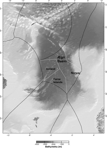
An interesting approach to the delimitation of the outer continental shelf is found in the trilateral Agreed Minutes on the Delimitation of the Continental Shelf beyond 200 Nautical Miles between the Faroe Islands, Iceland and Norway (Jan Mayen and mainland Norway) in the Southern Part of the Banana Hole of the Northeast Atlantic from 20 September 2006.Footnote 109 It has been noted that the agreement ‘is an outstanding example of foresight, cooperation, and innovation both legally and technically’.Footnote 110 The Agreed Minutes are not a treaty but a joint political statement. Although they are not a treaty its content should not be underestimated. They seem to be of a high level of significance. One indicator is the fact that the Agreed Minutes were signed by the ministers of foreign affairs of the three parties. An important factor in the making of the Agreed Minutes ‘was the desire to achieve a tripartitely negotiated solution of issues without giving rise to a number of complex legal issues’.Footnote 111 Consequently, no legal reasoning was formulated to justify the provisional boundary lines.Footnote 112 Another important factor was the previously determined maritime boundaries within 200 nm between the countries. No extensive knowledge of potential exploitable resources existed at the time of the negotiations.Footnote 113
The Agreed Minutes set out defined bilateral continental shelf boundaries beyond 200 nm between the opposite States and an agreed procedure for determining future delimitation lines in the southern part of the Banana Hole. The agreed boundary line has six fixed points which divide the area into three parts. Norway gets approximately half (55,528 km2) of the negotiated area and Iceland and Denmark (Faroe Islands) share the other half (56,000 km2).Footnote 114 Particular weight was not given to geological and geomorphological considerations with the exception that the parties assumed that the relevant area constituted a continuous continental shelf.Footnote 115
An important factor in the delimitation process seems to have been the fact that Norway has a two-sided inner continental shelf/EEZ opening to the area from continental Norway and Jan Mayen. It has been pointed out that ‘the resulting division of the delimitation area between the Parties played a role in the deliberations, in order to draw lines that would not lead to an inequitable result.’Footnote 116 However, ‘several of the resulting lines bear considerable resemblance to equidistance lines with adjustments, based on negotiations.’Footnote 117 Moreover, it seems as ‘previously concluded delimitation agreements for areas within 200 n.m. were not formally considered but may nevertheless in certain cases have provided inspiration for the assessment of what could constitute an equitable solution with regard to the delimitation beyond 200 n.m.’Footnote 118
The Agreed Minutes between Denmark (Faroe Islands), Iceland and Norway. Map prepared by ÍSOR – Iceland GeoSurvey

According to the Agreed Minutes, the three countries ‘wish to effect the delimitations of the continental shelf areas beyond 200 nautical miles from the baselines between’ the countries subject to the rights and obligations under UNCLOS.Footnote 119 The Agreed Minutes provide that ‘[t]his will be done taking into account, inter alia, the functions of’ the CLCS.Footnote 120 Moreover, the Agreed Minutes state:
If, after consideration of national data or other material by the Commission, it is ascertained that any part thereof belongs to ‘the Area’ … the coastal State(s) concerned will establish the outer limits of the continental shelf in accordance with Article 76(8) of the Convention, without this otherwise affecting [the boundary line].Footnote 121
This is an important provision in case the CLCS does not accept the parties’ claims to the entitlement of the continental shelf beyond 200 nm in the Banana Hole. Furthermore, the Agreed Minutes provide:
As soon as possible, and no later than three months after the States have concluded the procedure set out in Article 76(8) of the Convention, the States will meet with a view to simultaneously concluding three parallel bilateral agreements on the final determination of the boundary lines in accordance with these Agreed Minutes and their appendices … .Footnote 122
The Agreed Minutes do not state whether they are based on the assumption that the CLCS must give its recommendations before the outer limits of the continental shelf is delimited between the adjacent and opposite States or if this is a procedural method the three States agreed upon to delimit the boundary. Nonetheless, the Agreed Minutes are a good example of how States can cooperate to conclude outer continental shelf boundaries.
L. Kenya–Tanzania 2009
The 1976 Agreement between Kenya and the United Republic of TanzaniaFootnote 123 ‘establishes a territorial sea boundary between The Pemba Island (Tanzania) and the mainland of Kenya, which are opposite coasts, and then proceeds seaward to constitute an overall boundary line aimed at establishing “other areas of national jurisdiction” between the two states’.Footnote 124 The Agreement was concluded by exchange of notes. Natural resources (except fishing by indigenous fisherman) and geological and geomorphological considerations did not influence the actual location of the boundary line.Footnote 125
The boundary line consists of three turning points: A, B and C. The line seaward from point C is of interest for the continental shelf beyond 200 nm. It is a ‘line of latitude that neither approximates an equidistant line nor runs perpendicular to the general direction of the two nations’ coasts.’Footnote 126 According to the Agreement ‘[t]he eastward boundary from Point C … shall be the latitude extending eastwards to a point where it intersects the outermost limits of territorial water boundary or areas of national jurisdiction of two States.’Footnote 127 The 2009 Agreement between the United Republic of Tanzania and the Republic of Kenya on the Delimitation of the Maritime Boundary of the Exclusive Economic Zone and the Continental ShelfFootnote 128 states that ‘[t]his Agreement shall define the maritime boundary from the limits of the Territorial Waters as defined in the 1976 Maritime Boundary Agreement starting at Point C.’Footnote 129 According to Article 2 of the 2009 Agreement ‘[t]he Parties agree that the boundary line extends eastwards to a point where it intersects the outermost limits of the continental shelf and such other outermost limits of national jurisdiction as may be determined by international law.’ As with the 1975 Gambia–Senegal Agreement, it seems that the idea behind this arrangement is that it is the task of the two States to define the terminus of the boundary line after they have made their submissions to the CLCS and received the CLCS recommendations.
M. Barbados–France 2009
The 2009 Agreement between the Government of the French Republic and the Government of Barbados on the Delimitation of Maritime Areas between France and BarbadosFootnote 130 is a short and simple agreement. The agreement delimits the maritime area between Barbados and Guadeloupe and Martinique (France) in the Caribbean Sea. The agreement mainly concerns the delimitation of the EEZ. However, it provides that ‘[i]f the continental shelf of Barbados and that of France overlap beyond two hundred nautical miles’ the delimitation line is extended to a certain geographic coordinate.Footnote 131 The boundary line is an equidistance line between Martinique alone (not Guadeloupe) and Barbados.Footnote 132 No special circumstances were deemed to exist that justified modifications to the line.Footnote 133 No geological and geomorphological considerations influenced the outcome.Footnote 134 The agreement makes no explicit reference to the CLCS or to Article 76 of UNCLOS, although it mentions in its preamble ‘the rules and principles of international law’ in particular UNCLOS. Nevertheless, the CLCS will play an important role in this context since it is left to the Commission to verify whether the States are entitled to the continental shelf beyond 200 nm. Consequently, the terminus remains undefined.
N. Russia–Norway 2010
The 2010 Treaty between the Kingdom of Norway and the Russian Federation concerning Maritime Delimitation and Cooperation in the Barents Sea and the Arctic OceanFootnote 135 marked the end of a 40-year-old maritime boundary dispute between the parties. The treaty delimits an area that can be divided into three parts. The first begins ‘at the mouth of the Varangerfjord and extends to 200 nautical miles from the mainlands of Norway and Russia … The second area is in the middle of the Barents Sea beyond 200 miles (the Barents Sea Loophole) … The third area is in the northern Barents Sea’.Footnote 136 It is only in the second area and in a short section of the third area that an outer continental shelf boundary between the opposite coasts of the mainland of Norway and Svalbard and of Russia (Novaya Zemlya) was required.
The eight coordinate delimitation line is a single line within 200 nm. The continental shelf boundary extends beyond that limit where the parties’ shelf extends beyond 200 nm. It must be emphasized that Norway was in the unusual position that CLCS had accepted her claim to the area beyond 200 nm before the treaty was concludedFootnote 137 and the CLCS had indicated in its recommendations to Russia that a ratified maritime boundary agreement with Norway in the Barents Sea ‘would represent the outer limits of the continental shelf of the Russian Federation extending beyond 200 nautical miles in the Barents Sea’.Footnote 138
The treaty does not reveal much about the delimitation method except that the preamble makes reference to the provisions of UNCLOS. A joint statement made by the Russian President and the Norwegian Prime Minister a few months before the conclusion of the treaty reveals more.Footnote 139 According to the statement, delegations from the parties recommended ‘a delimitation line on the basis of international law in order to achieve an equitable solution’Footnote 140 and that the line should divide ‘the overall disputed area in two parts of approximately the same size’.Footnote 141 The only relevant factor mentioned is ‘the effect of major disparities in respective coastal lengths’.Footnote 142 The statement does not make reference to the median line, equidistance line or a bisector line. Nor does it make reference to economic factors, although they were an important underlying factor. Moreover, it is difficult to evaluate whether geological or geomorphological factors were applied.
O. Uruguay–Argentina 1973—an outer continental shelf boundary?
There is disagreement as to whether or not the extensive 1973 Agreement between the Government of Argentina and the Government of Uruguay Relating to the Delimitation of the River Plate and the Maritime Boundary between Argentina and UruguayFootnote 143 delimits the continental shelf beyond 200 nm. As its name indicates, the Agreement delimits the boundary between the two countries in the river Río de la Plata and establishes the maritime boundary between the parties, seaward of the closing line at the mouth of the river.Footnote 144 Article 70 of the Agreement provides that:
The lateral maritime boundary and the continental shelf boundary between the Oriental Republic of Uruguay and the Argentine Republic are defined by an equidistant line, determined by the adjacent coasts methods, which begins at the midpoint of the baseline consisting of an imaginary straight line that joins Punta del Este (Uruguay) and Punta Rasa del Cabo San Antonio (Argentina).
Jiménez de Aréchaga has pointed out that ‘[t]he outer limit of the boundary line, seaward of the closing line is not indicated. This is perhaps because the continental shelf in this area has a natural prolongation beyond 200 nautical miles … which would eventually be subject to the rules of delimitation with the area provided’ in Article 76(4–6) and Annex II of UNCLOS.Footnote 145 Uruguay's submission to the CLCS is silent on this issue. It only states that ‘[t]here exist, at present, no unresolved disputes over the maritime border with either of Uruguay's neighbouring countries, Argentina or Brazil.’Footnote 146 Nevertheless, one of the points that Uruguay uses in its submission (FP 01), the southernmost point of the submission is located 350 nm from the territorial sea baselines. According to Uruguay's submission, the point ‘is equidistant from Punta Médenos in Argentina … and Cabo Santa María in Uruguay … compliant with Article 70’ of the Treaty of the River Plate and its Maritime Front.Footnote 147 Hence it appears that Uruguay is of the opinion that the agreed boundary line extends to the outer continental shelf. Argentina, however, is clearly of the opinion that there exists no maritime boundary between the States beyond 200 nm. Argentina's submission to the CLCS states:
The boundary between the Argentine and Uruguayan continental shelves beyond the 200 nautical miles from the baselines is still to be demarcated … The abovementioned point FP 01 of the Uruguayan submission cannot be taken as a point of the maritime lateral boundary between the two countries since such boundary has not yet been demarcated in that sector, an operation which must necessarily be bilateral.Footnote 148
Consequently, Argentina requested the Commission to formulate its recommendations applying paragraph 4(a) of Annex I of its Rules of Procedure.Footnote 149 The submissions of the two States are currently pending before the CLCS. The question that arises here—and which is of general importance for maritime boundary delimitations—is whether a maritime boundary, which only defines a specific direction for the boundary line without indicating where the boundary terminates, extends automatically beyond 200 nm or whether the parties to a boundary agreement must explicitly state that it does so. In the Black Sea Case the ICJ noted that ‘[S]tate practice indicates that the use of a boundary agreed for the delimitation of one maritime zone to delimit another zone is effected by a new agreement.’Footnote 150 In the view of Anderson, ‘[t]he Court's approach appears to mean that pre-existing boundaries only continue to serve for the purposes for which they were originally intended, and that they are not automatically transformed into boundaries serving other purposes absent the agreement of the Parties.’Footnote 151 It could therefore be argued that in disputes such as that between Argentina and Uruguay, it will be essential to show whether the boundary agreement was or was not intended to delimit the entire continental shelf or not.
On the other hand, the dispute in the Black Sea Case was about the establishment of a single maritime boundary delimiting the continental shelf and EEZ within 200 nm.Footnote 152 The dispute between Argentina and Uruguay is different. It is only about the continental shelf. This fact creates a complexity as ‘there is in law only a single “continental shelf” rather than an inner continental shelf and a separate extended or outer continental shelf.’Footnote 153 It could therefore be argued that the dicta from the Black Sea Case is not applicable in disputes regarding the extent of boundary lines that only specify a direction for the continental shelf boundary without defining its point of termination. In the circumstances of Uruguay and Argentina, two arguments strengthen this view. First, Article 83(4) of UNCLOS provides that ‘[w]here there is an agreement in force between the States concerned, questions relating to the delimitation of the continental shelf shall be determined in accordance with the provisions of that agreement.’ Second, at the time the boundary agreement was concluded, the applicable legal regime made no distinction between broad and narrow continental shelves.Footnote 154 Consequently, the argument can be made that the agreed boundary line between Uruguay and Argentina extends beyond 200 nm.
P. Brazil and Neighbouring States
In its submission to the CLCS, Brazil noted that ‘it is not involved in any territorial dispute concerning maritime areas with another State.’Footnote 155 Brazil has concluded maritime boundaries agreements with its neighbours, French Guiana and Uruguay. The boundary line with French Guiana, which presumably is a single line, does not have a defined terminus.Footnote 156 The boundary with Uruguay, as agreed in the 1972 agreement neither has a defined terminus. It can, however, be assumed that it was not meant to extend beyond 200 nm since the boundary delimitation agreement between the parties stated that the boundary line extended ‘to the outside limit of the territorial sea of both countries’Footnote 157 which, according to their domestic legislation, ‘at the time the agreement was signed, was 200 n.m. for both states’.Footnote 158. Brazil seems to assume ‘that the extension of the continental shelf does not pose delimitation questions with neighbouring countries … and that it accepts that a seaward extension of the existing lateral delimitation will apply’.Footnote 159 In the case of Uruguay, this seems to be accurate since, as mentioned above, Uruguay's submission to the CLCS states that ‘[t]here exist, at present, no unresolved disputes over the maritime border with either of Uruguay's neighbouring countries, Argentina or Brazil.’Footnote 160 The situation is different in the case of French Guiana. French Guiana did not make a note verbale commenting on this aspect of Brazil's submission.Footnote 161 This could be seen as a verification of Brazil's position. On the other hand it must be kept in mind that ‘[t]he establishment of a permanent maritime boundary is a matter of grave importance and agreement is not easily to be presumed.’Footnote 162 Consequently, without any input from French Guiana it is difficult to assume that the maritime boundary between the two adjacent States should be seen as extending beyond 200 nm.
IV. Trends in State Practice
A. The Delimitation Method
Against this background, five assertions can be made about the State practice regarding the method used to locate the boundary line in the outer continental shelf. First, States have obviously utilized the flexibility inherent in negotiations when the delimitation method used to conclude the agreements was adopted. Second, some of the existing boundary agreements extend previously concluded boundary lines beyond 200 nm without a change in direction (1975 Gambia–Senegal Agreement; 2000 Mexico–USA Agreement; and the 2009 Kenya–Tanzania Agreement). Third, a few of the agreements which delimit the inner and outer continental shelf extend the inner line without a change of direction to the outer line (1982 Australia–France Agreement; 1988 Australia–Solomon Islands Agreement; 1990 Trinidad and Tobago–Venezuela Agreement; 1990 USA–USSR Agreement; 2009 Barbados–France Agreement). Fourth, it appears that geoscientific factors have played a role in five agreements (1978 Australia–Papua New Guinea Agreement; 1988 Ireland–UK Agreement; the 1990 Trinidad and Tobago–Venezuela Agreement; the 1997 Australia–Indonesia Agreement; and the 2004 Australia–New Zealand Agreement). Fifth, no delimitation method dominates. The equidistance line or a modified equidistance line has been used in five agreements (1982 Australia–France Agreement, 1988 Australia–Solomon Islands Agreement, 1990 Trinidad and Tobago–Venezuela Agreement; 2000 Mexico–USA Agreement, 2009 Barbados–France Agreement) whilst some have used other methods. Some follow lines of longitude or latitude (1975 Gambia–Senegal Agreement; 1990 USA–USSR Agreement) whilst a mixture of methods or considerations are used in other agreements (1978 Australia–Papua New Guinea Agreement; 1988 Ireland–UK Agreement; 1997 Australia–Indonesia Agreement; 2004 Australia–New Zealand Agreement; 2006 Faroe Islands, Iceland, Norway Agreed Minutes; 2009 Kenya–Tanzania Agreement; 2010 Russia–Norway Agreement).
B. Have States Waited for the Recommendations from the Commission on the Limits of the Continental Shelf?
Of the 14 clearly concluded maritime boundary agreements in which the outer continental shelf is delimited, 12 agreements have been concluded before one or both of the parties received recommendations from the CLCS. One agreement was concluded after both parties had received recommendations (the 2010 Russia-Norway Agreement) and one set of trilateral agreed minutes have been concluded (the 2006 Faroe Islands, Iceland, Norway Agreed Minutes), which provisionally delimits the outer continental shelf and creates a process involving submissions to the CLCS before the boundary is finally delimited. One of the agreements is rather unusual. As noted above, the 1997 Australia–Indonesia Agreement extends the continental shelf of Australia beyond 200 nm where the relevant maritime area in issue is less than 400 nm in width.
Eleven agreements that delimit the outer continental shelf, without any existing recommendations from the CLCS (or even before the CLCS was established) have been concluded after the provisions of UNCLOS on the continental shelf beyond 200 nm were finalized at the Third United Nations Conference on the Law of the Sea, involving 17 States, of which 15 are parties to UNCLOS. One agreement was concluded before UNCLOS itself was finalized (the 1978 Australia–Papua New Guinea). Third States have not protested this practice. It seems that States have tacitly accepted that the delimitation and delineation of the outer continental shelf are separate functions.Footnote 163 It could be argued that this fact needs to be taken into account when interpreting UNCLOSFootnote 164 which seems to be what ITLOS did in the Bay of Bengal Case:
The Tribunal observes that the exercise of its jurisdiction in the present case cannot be seen as an encroachment on the functions of the Commission, inasmuch as the settlement, through negotiations, of disputes between States regarding delimitation of the continental shelf beyond 200 nm is not seen as precluding examination by the Commission of the submissions made to it or hindering it from issuing appropriate recommendations.Footnote 165
The discussion above clearly shows that States that have engaged in the delimitation of the outer continental shelf, in general, have not waited for recommendations from CLCS before delimiting the boundary line beyond 200 nm. How States show that they are entitled to the continental shelf beyond 200 nm is a different, but related, question which will not be answered here.Footnote 166
C. Terminus
Four propositions can be made about the location of the terminus in the above agreements. First, three agreements leave the terminus of the boundary line undefined, ie they define a specific direction for the boundary line without defining where the boundary terminates. Neither the 1975 Gambia–Senegal Agreement nor the 2009 Agreement between the Governments define a terminus of the boundary line. This implies that the States plan to define the terminus after they have received recommendations from the CLCS. The 1990 USA–USSR Agreement extends the boundary line far into the Arctic along a meridian line. How the two States plan to define the terminus is unclear. Difficult questions arise in this instance given that the US is not a party to UNCLOS.Footnote 167 The 2009 Kenya–Tanzania Agreement states that the boundary line extends ‘to a point where it intersects the outermost limits of the continental shelf and such other outermost limits of national jurisdiction as may be determined by international law’.Footnote 168 This implies that the terminus will be defined after the States receive CLCS recommendations and there is a possible third-party factor that needs to be addressed. A similar approach, though more cautious, is taken in the 2009 Barbados–France Agreement which states that if the continental shelf of Barbados and that of France overlap beyond 200 nm, the delimitation line is extended to a certain geographical coordinate.Footnote 169 This implies that the boundary line will not be extended beyond 200 nm until positive CLCS recommendations have been received.
Second, four agreements—the 1982 Australia–France Agreement, the 1988 Ireland–UK Agreement, the 1990 Trinidad and Tobago–Venezuela Agreement and the 2004 Australia–New Zealand Agreement—define a terminus, but note that it can be adjusted in the future. The terminus in the 1990 Trinidad and Tobago–Venezuela Agreement needs to be relocated since it ‘falls appreciably short of the outer limit of the continental shelf’.Footnote 170
Third, two agreements, the 2000 Mexico–USA Agreement and the 2006 Faroe Islands, Iceland, Norway Agreed Minutes fill a gap or loophole between the parties. The former agreement did so without considerations regarding the CLCS; the latter, however, introduces a certain process that involves considerations regarding the CLCS.
Fourth, four agreements are not relevant in this context. The 1978 Australia–Papua New Guinea Agreement was concluded before the provisions on the outer continental shelf in UNCLOS were crystallized. The boundary line of the 1988 Australia–Solomon Islands Agreement is connected to other boundaries. The outer continental shelf part of two boundaries, the 2010 Russia–Norway Agreement and the 1997 Indonesia–Australia Agreement, is landward of the boundary terminus.
D. Customary International Law?
As is well known, ‘international custom, as evidence of a general practice accepted as law’ can be applied by the ICJ when deciding disputes.Footnote 171 The relevant acts must ‘amount to a settled practice’ and ‘be carried out in such a way, as to be evidence of a belief that this practice is rendered obligatory by the existence of a rule of law requiring it’.Footnote 172 One of the requirements in establishing state practice is to show that it has been applied constantly,Footnote 173 extensively and in a virtually uniform manner.Footnote 174 As discussed above, the delimitation method used in the existing outer continental shelf agreements has not been applied constantly and in a virtually uniform manner. The same can be said about the location of the terminus. Although the majority of States concluding an outer continental shelf boundary agreement have done so before making a submission to the CLCS or receiving its recommendations, some States have concluded an agreement after receiving the recommendations. This practice confirms that the delineation and delimitation procedures are separate processes, as stated in Article 76(10) and Article 9 of Annex II to UNCLOS and by ITLOS in the Bay of Bengal Case.Footnote 175 The practice is perhaps more important for the interpretation of the Convention than for the establishment of customary international law. For these reasons it seems that the general practice requirement needed to establish customary international law has not been fulfilled and consequently no special rules of customary international law have emerged that are especially applicable to outer continental shelf delimitations.
V. Conclusion
The analysis of the concluded boundary agreements that delimit the outer continental shelf seem to confirm that no delimitation method has been used in a virtually uniform manner in maritime boundary agreements that delimit the outer continental shelf. The same applies to the allocation of the terminus of the boundary line. On the other hand the majority of States that have concluded outer continental shelf boundary agreements have done so before making a submission to the CLCS or receiving its recommendations. This fact was not overlooked by ITLOS in the Bay of Bengal Case and seems to have been an important factor when the Tribunal held that it had jurisdiction in the case. Other factors of State practice in this field were not introduced in the litigation in Hamburg and consequently had no role.
It seems clear that no special rule of customary international law has evolved that is only applicable to outer continental shelf delimitations. In general, maritime boundary agreements involving the outer continental shelf are very similar to agreements that stop at the 200 nm limit. Nevertheless, it is likely that the boundary agreements discussed above do not go unnoticed by State officials and will influence future maritime boundary negotiations, hopefully providing stability, thereby contributing to the peaceful coexistence of States.