1. Introduction
One hundred years ago, W. B. Wright (Reference Wright1911) first described a well-developed raised rock shoreline across parts of the Scottish Inner Hebrides (Fig. 1). Wright described the feature as ‘preglacial’ in age in the sense of having been produced prior to the only apparent general glaciation of the area. These platform fragments of the Inner Hebrides are typically west-facing, between 200–600 m in width and backed by cliffs up to 90 m high. In many locations the platform surfaces are till-covered and ice-moulded, with the altitude of the platform-cliff junction (where it can be determined) typically between 18 m and 35 m OD (above ordnance datum). In some areas (e.g. Islay and Jura), the altitude of the cliff-platform junction varies by several metres over short distances (<2 km), this variation being attributed to Pleistocene tectonic deformation (Dawson, Reference Dawson, Gordon and Sutherland1993).
Areas of strandflat in the Scottish Hebrides (shaded white) together with known areas of high rock platform. Published altitudes of cliff-platform junctions (m OD) are also shown (based on A. G. Dawson, unpub. Ph.D. thesis, Univ. Edinburgh, Reference Dawson1979; Sissons, Reference Sissons1982). Generalized ice flow lines based on striae, ice-moulded landforms and alignment of glacially-overdeepened troughs (arrows) illustrate the preservation of areas of high rock platform ‘down-ice’ in lee of major rock ridges (cf. Sissons, Reference Sissons1967). Profile lines A–B and C–D are shown in detail in Figure 4.

For the Scottish Outer Hebrides, by contrast, it has always been assumed that there are no shorelines above present-day sea-level because of glacio-isostatic subsidence produced by forebulge collapse associated with deglaciation of the Scottish mainland. Whilst this may be true in respect of Lateglacial and Holocene sea levels, it cannot be true in respect of those raised rock platforms which form such conspicuous features in the landscape of the Outer Hebrides. Indeed, it is argued here that some of the most spectacular and finest examples of raised rock platforms in northern Europe occur across the islands of the Scottish Outer Hebrides at elevations up to 30 m OD. The possible ages and origins of these raised features are described here together with a re-interpretation of the origin of the high rock platform features of the Scottish Inner Hebrides as previously postulated by earlier authors.
2. Background
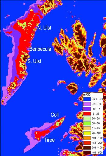
The islands of South Uist, Benbecula and North Uist in the Scottish Outer Hebrides mostly consist of extensive areas of raised rock platform 3–15 km in width and cut in Lewisian gneiss, which extend eastwards from the Atlantic coast as far as a belt of N-trending hills along the eastern margin of the island chain. These areas of platform are so extensive that they constitute nearly the entire landscape of these islands (Fig. 1). The platform surfaces are everywhere ice-moulded with topographic depressions mostly occupied by a myriad of small shallow lochs (lakes). Across inland areas, the platform surfaces are peat-covered and, in localized areas, mantled by a thin cover of glacial drift. Along the Atlantic margin of the island chain, the platform surfaces are covered by calcareous sand that forms the classic ‘machair’ landscape that is succeeded at the coast by vegetated coastal dunes. The detailed relief of this planar rock landscape reflects the strong influence of Pleistocene glaciation that has produced a multitude of roches moutonnées that, together, represent most of the visible bare rock surfaces.
The areas of planated rock also extend offshore. GIS mapping of bedrock surfaces with a surface slope of <0.3° point to the presence of several distinct rock surfaces separated by low rock steps (Fig. 2). Across South Uist, Benbecula and North Uist, the highest surface extends seaward from +25 m in the east to −6 m OD with an average surface seaward slope of 0.09°. Two lower surfaces with similar shallow surface slopes exist between −7 m and −19 m OD and from −20 m to −29 m OD (Fig. 2).
Map of surface slopes highlighting three different strandflat surfaces (red – highest; dark purple – middle; light purple – lowest) separated by low rock ‘steps’ characterized by slope values >0.3°.

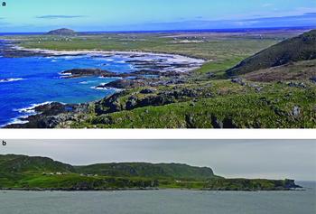
The highest of the three rock surfaces is the widest feature (up to 15 km wide in Benbecula) and extends seaward (westwards) from the base of a drift-mantled and ice-moulded inland cliff. Digital mapping of surface slope variations show that the highest platform extends across the intertidal zone to a depth offshore of −7 m OD where there is a well-defined c. 2 m high rock step to a lower (submerged) platform. Similar well-developed raised rock platforms in gneiss also occur in the islands of Tiree and Coll and in adjacent offshore areas (Fig. 3a). The entire landscape of Tiree is represented by very wide ice-moulded raised rock platforms that together cover an area of c. 80 km2. The gneiss platform surfaces continue eastwards onto the SW part of Coll where they end at an ice-moulded cliff-line (Fig. 1), possibly analogous to that marking the inland (eastward) limit of the platform surfaces in the Outer Hebrides.
(a) Strandflat on Tiree developed in Lewisian gneiss (see Fig. 1). The platform is everywhere ice-moulded and mantled by Holocene dunes, machair and raised beach gravels. At two locations, former gneiss ‘islands’ (middle distance and foreground) protrude above the platform surface (photo courtesy of J. Gordon). (b) High rock platform developed in Torridonian sandstone, western Colonsay, Scottish Inner Hebrides (see Fig. 1). Here the platform has been preserved from the effects of glacial erosion by a rock ridge. The feature is also till-covered (photo courtesy of J. Gordon).

Detailed descriptions of high rock platform fragments have been provided for many areas of the Scottish Inner Hebrides including Colonsay, Islay, Jura, western Mull, Skye and Rum (Wright, Reference Wright1911; McCann, Reference McCann, Bowen, Carter and Taylor1968; McCann & Richards, Reference McCann and Richards1969; Richards, Reference Richards1969; A. G. Dawson, unpub. Ph.D. thesis, Univ. Edinburgh, Reference Dawson1979; Fig. 3). McCann (Reference McCann, Bowen, Carter and Taylor1968) re-interpreted the ‘preglacial’ platform hypothesis of Wright (Reference Wright1911) and introduced the view that the features were classic ‘wave-cut platforms’ produced during Pleistocene interglacials and that the distribution of the features in the lee of major rock ridges points to their preservation from subsequent glacial erosion (e.g. Fig. 3b). An ‘interglacial’ hypothesis, however, is difficult to reconcile with the marine oxygen isotope record which points to relative sea level during the Pleistocene never having been stable for long enough to enable the production of wide shore platforms in the variety of resistant metamorphic rocks in which they are developed, a point also made by Le Coeur (Reference Le Coeur1988). A different interpretation was provided by Sissons (Reference Sissons1982) who argued that the features were produced rapidly through a combination of cold climate shore erosion and wave action mostly during the last (Devensian) glaciation, at a time when the western margin of the last Scottish ice sheet was located across the Scottish Inner Hebrides. Sissons (Reference Sissons1982) recognised that some high rock platform fragments may also have been cut by similar processes during earlier Pleistocene glacial periods prior to the Devensian. Part of his hypothesis was based on the recognition that widespread evidence exists from present-day high-latitude coastlines that cold climate coastal erosion of bedrock can take place rapidly through the combined action of frost-shattering and the removal of debris offshore by sea ice transport (A. G. Dawson, unpub. Ph.D. thesis, Univ. Edinburgh, Reference Dawson1979; Dawson, Reference Dawson1979; Dawson, Reference Dawson, Lowe, Gray and Robinson1980; Gray & Ivanovich, Reference Gray and Ivanovich1988).
The cold climate shore erosion hypothesis was also invoked by Dawson (Reference Dawson1994) to account for the wide platforms on Tiree and Coll (Fig. 3a). Dawson (Reference Dawson1994) considered the Tiree and Coll features a ‘strandflat’ similar to the well-known features that occur along the west coast of Norway and which are cut in a range of resistant rock types including phyllite, schistose limestone, quartzite, granite, gneiss and gabbro (Nansen, Reference Nansen1922; Holtedahl, Reference Holtedahl1929; Kranck, Reference Kranck1950; Moign, Reference Moign1974; Holtedahl, Reference Holtedahl1998; Corner, Reference Corner and Seppala2005).
No general agreement has ever been reached as to the mechanics of strandflat formation. The most widely-discussed processes of strandflat formation are summarized by Larsen & Holtedahl (Reference Larsen and Holtedahl1985) and include marine abrasion, subaerial weathering, glacial erosion, frost shattering and cold climate shore erosion. Holtedahl (Reference Holtedahl1929) and Dahl (Reference Dahl1947), for example, maintained that the strandflat was primarily formed by erosion accomplished by corrie (cirque) glaciers together with marine erosion accompanied by freeze-thaw effects. In contrast, Larsen & Holtedahl (Reference Larsen and Holtedahl1985) proposed that the strandflat was primarily the result of sea-ice erosion and frost-shattering during the Pleistocene with most surfaces being further modified by subsequent marine and glacial erosional processes. We argue here that the extensive platform surfaces of South Uist, Benbecula and North Uist represent the most conspicuous element of an extensive glaciated strandflat that occurs across western Scotland, and that the high rock platform of the Inner Hebrides described by previous authors represents part of the same feature.
3. Platform origin and age
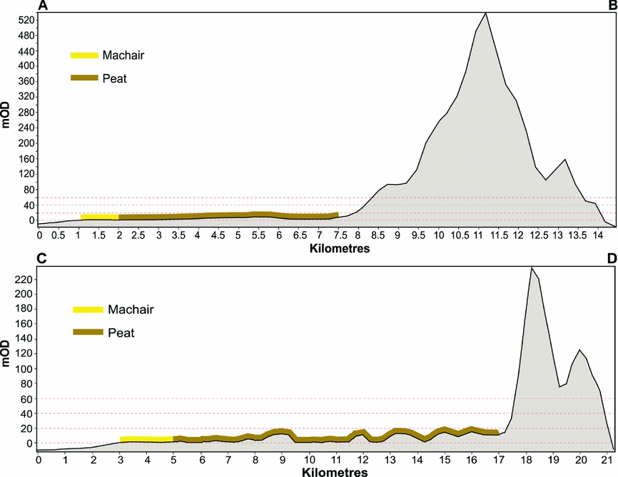
The exceptional widths of the strandflat surfaces always represented a key difficulty in every hypothesis of origin that has been proposed. The premise that the platforms were produced by wave erosion always encounters the difficulty that once a platform reached a critical width, wave action would be incapable of widening it further since the zone of wave breaking would be displaced offshore far from the cliff base (Trenhaile, Reference Trenhaile1983). Modelling of the Pleistocene evolution of shore platforms and erosional continental shelves has shown that wide (several km) rock platforms can be cut under conditions of rising or fall sea-level (Trenhaile Reference Trenhaile, Lakhan and Trenhaile1989, Reference Trenhaile2001). The modelled platform surfaces typically have seaward gradients of c. 1°, equivalent to a notional vertical difference of 100 m across a 7 km-wide platform. By contrast, the strandflat surfaces described here are characterized by surface slopes typically an order of magnitude lower than those modelled by Trenhaile (Reference Trenhaile, Lakhan and Trenhaile1989, Reference Trenhaile2001; Fig. 4). Furthermore, in areas where the strandflat is developed, the presence of ice-moulded and striated strandflat rock surfaces at present sea level demonstrates that wave erosion has been negligible over the last c. 2000 years during which relative sea level has been in the same approximate position (Jordan et al. Reference Jordan, Smith, Dawson and Dawson2010).
Strandflat cross-profiles for locations A–B and C–D (see Figure 1) also showing extent of peat and machair sand cover.

A possible candidate process for strandflat formation is linked to the relatively rapid cliff retreat rates associated with shoreline erosion under periglacial conditions (Jahn, Reference Jahn1961; Dawson, Reference Dawson, Lowe, Gray and Robinson1980; Rasmussen, Reference Rasmussen1981; Matthews et al. Reference Matthews, Dawson and Shakesby1986; Dawson et al. Reference Dawson, Matthews, Shakesby and Boardman1987; Aarseth & Fossen, Reference Aarseth and Fossen2004). Field measurement of shore platform fragments developed in metamorphic rocks along the margin of a glacier-dammed lake in Jotunheimen, southern Norway, pointed to an inferred cliff retreat rate of 26–44 mm yr−1 during the Little Ice Age (Matthews et al. Reference Matthews, Dawson and Shakesby1986). Similarly, Jahn (Reference Jahn1961) concluded that recent rates of bedrock cliff retreat in Spitsbergen are 25–50 mm yr−1 while from Norway and Scotland, shore platform fragments cut in a variety of metamorphic rock types during the Younger Dryas cold spell are estimated to have been associated with cliff retreat rates of c. 40–70 mm yr−1 (Jahn, Reference Jahn1961; Dawson, Reference Dawson, Lowe, Gray and Robinson1980; Rasmussen, Reference Rasmussen1981; Matthews et al. Reference Matthews, Dawson and Shakesby1986; Dawson et al. Reference Dawson, Matthews, Shakesby and Boardman1987). If these latter processes and rates of cliff retreat represent the most effective means of producing shore platforms, an area of strandflat c. 7 km in width would take at least 100000 years to be cut, provided relative sea level remained in the same approximate position throughout that period. The marine oxygen isotope record demonstrates that it is unlikely that such periods of prolonged stability of sea level could have occurred during the Pleistocene. Not only were such periods characterized by significant glacio-eustatic changes but rates of glacio-isostatic rebound were also considerable and have been characterized by significant spatial variability. We therefore find it hard to understand how such wide rock platforms could have been cut during the Pleistocene.
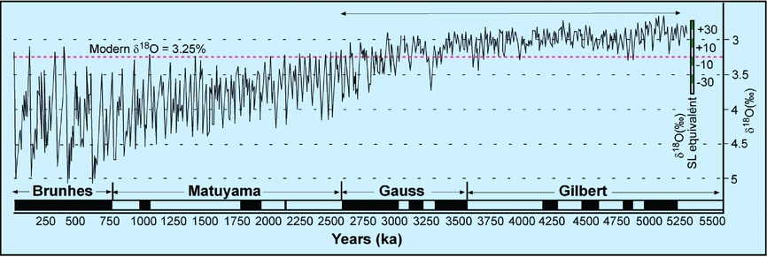
If we hypothesize that the Inner and Outer Hebrides platforms are of the same age, it is necessary to address the resulting constraint on the age of the Scottish strandflat; that it must be younger than the youngest rocks across which it is cut (the Tertiary basalt sheets of the islands of Skye, Mull and Rum). This would further support the case for a Pliocene (rather than an Eocene or Miocene) age for the strandflat, an argument which is further boosted by evidence of Tertiary global ocean volumes, as inferred by using the oxygen isotope record as a proxy for globally averaged sea levels. These would appear to have been very much higher throughout the Eocene prior to the initial growth of Antarctic ice, an interpretation supported by low (<2‰) marine oxygen isotope ratios for this time interval (Zachos et al. Reference Zachos, Dickens and Zeebe2008). Similarly, the oxygen isotope stratigraphy for the Oligocene and Miocene (values lower than 3‰) points to a similar conclusion (Zachos et al. Reference Zachos, Dickens and Zeebe2008). By contrast, global ocean volume starts to fall to levels closer to present during the Pliocene (cf. Larsen et al. Reference Larsen, Saunders, Clift, Beget, Wei and Spezzaferri1994; Raymo et al. Reference Raymo, Hearty, De Conto, O'Leary, Dowsett, Robinson and Mitrovica2009; Fig. 5). It is argued therefore, that global sea levels were too high during the Miocene, Oligocene and Eocene for the observed strandflat development to have taken place and, in conjunction with differential glacio-isostatic rebound patterns, never stable for long enough during the Pleistocene to enable platform production to occur.
Marine oxygen isotope stratigraphy for Pliocene and Pleistocene and inferred approximate equivalent sea level based on ice volume estimates (adapted from Raymo et al. Reference Raymo, Hearty, De Conto, O'Leary, Dowsett, Robinson and Mitrovica2009). The time interval c. 2.5–5.5 Ma (arrowed) is considered here as the optimum time interval for strandflat production and permitting an approximate glacio-eustatic sea-level range from +30 m to −30 m.

Accordingly, a Pliocene age for any Scottish strandflat is preferred since not only had global sea level lowered to an elevation at which strandflat formation was a realistic possibility (in Scotland below c. 30 m OD) but also marine planation at this time could have taken place relatively rapidly if the rock surfaces had already been subject to several million years of deep chemical weathering. Notably in Scotland, the widest areas of strandflat are everywhere developed in Lewisian gneiss, prompting the suggestion that the features were ‘pre-prepared’ by chemical weathering associated with the breakdown of feldspar minerals, a process analogous to the well-known chemical weathering hypothesis of tor formation (Eden & Green, Reference Eden and Green1971; A. M. Hall, unpub. Ph.D. thesis, Univ. St Andrews, 1983; Twidale et al. Reference Twidale, Bourne and Romani2005;). In this way, shore platforms could have been eroded and widened relatively quickly provided that relative sea level remained in the same approximate position for long enough.
An important conclusion arising from a preferred Pliocene age for the strandflat is that the platforms ought not to exhibit glacio-isostatic tilting since glacio-isostatic rebound over the last c. 10 ka of the present (Holocene) interglacial is nearly complete. In addition, one might envisage that individual platform fragments may have been subject to cycles of vertical glacio-isostatic deformation (uplift and downwarping) associated with the growth and decay of Pleistocene ice sheets together with localized vertical tectonic movements as have been postulated for the high rock platform fragments in Islay and Jura (Dawson, Reference Dawson, Gordon and Sutherland1993). The altitude of individual strandflat surfaces is also likely to have been additionally affected by long-term glacio-isostatic readjustment (uplift) caused by cumulative glacial erosion across Scotland during the Pleistocene together with loading (subsidence) of the continental shelf due to cycles of ice-marginal sedimentation. In addition, the morphology of individual platform surfaces has been shaped by successive episodes of glacial erosion during the Pleistocene. It is suggested here that spatial variations in the altitude of strandflat features across western Scotland are principally due to the above processes.
Wide marine planation surfaces of presumed Pliocene age also exist elsewhere in the world. Some have been directly attributed to formation during the Pliocene (e.g. the Citronelle Formation of southeastern USA; Isphording, Reference Isphording1970) while others are simply regarded as ‘preglacial’ features (e.g. the wide intertidal platforms of the Channel Isles and northern France; Coope et al. Reference Coope, Dickson, Jones and Keen1986). Whilst a detailed discussion of such features is outside the scope of this paper, it is important to recognise that marine planation surfaces equivalent in age to the strandflat may exist in lower latitudes.
4. Summary
This study presents a speculative hypothesis to explain the existence of extensive areas of potential strandflat across the Scottish Outer Hebrides. The strandflat hypothesis also provides an elegant explanation for the origin and age of the high rock platform fragments that occur throughout the Scottish Inner Hebrides. Our hypothesis challenges published interpretations that the high rock platform fragments are Pleistocene features, and proposes instead that these landforms are remnants of a formerly more extensive Pliocene strandflat surface(s) across western Scotland, the majority of which has been removed by Pleistocene glacial erosion. A key element of this interpretation is that those high rock platform fragments are nearly always located down-ice of major rock ridges and thus could have survived repeated episodes of Pleistocene glacial erosion.
Without exception, all extensive areas of strandflat in the Scottish Outer Hebrides are developed in gneiss and we suggest, by association, that these areas may have been subject to deep chemical weathering prior to platform production. The recognition that shore platforms can be produced rapidly in cold climate coastal environments raises the question: could such cold conditions have existed across northern Europe during the Pliocene sufficient to have produced strandflat surfaces by frost-related coastal processes as first envisaged and described by Nansen (Reference Nansen1922)? The answer is probably no, since the oldest ice-rafted detritus observed in North Atlantic marine cores dates to c. 2.8 Ma (Mangerud et al. Reference Mangerud, Gyllencreutz, Lohne, Svendsen, Ehlers, Gibbard and Hughes2011). This observation points to chemical weathering as an important precursor of platform production, although the role played by cold climate coastal processes in strandflat formation during the Pliocene cannot be entirely ruled out.
Acknowledgements
Brice Rea kindly commented on earlier drafts of this paper. Gratitude is also expressed to Cristina Gómez and Alison Sandison. The paper is a contribution to the Scottish Alliance for Geoscience, Environment and Society (SAGES) and NPP Coastadapt.