BERKSHIRE
(1) Caversham, Mapledurham Playing Fields (SU 6985 7563): a large D-shaped Roman enclosure was found on the eastern side of the site.Footnote 156 Inside the enclosure were a gully and two post-holes which produced Iron Age pottery. The enclosure ditches contained pottery dating from the first to second century. The presence of a Samian ware mortarium fragment suggests a date after c. a.d. 170, implying several phases of occupation and potential industrial activity. An evaluation in 1998 uncovered similar Roman features c. 250 m north-west of the site, and rectangular cropmarks suggest that this site could have been part of a substantial late Iron Age/Roman rural settlement.
(2) Lambourn, Collingridge Farm (SU 32886 78906): ditches, pits and post-holes were recorded. The remains were more concentrated in the northern higher area and are likely to represent parts of a multi-phased settlement, which is dated to a.d. 150–250 on the basis of pottery.Footnote 157
EAST SUSSEX
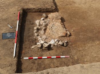
(1) Ringmer, Bridge Farm, Wellingham (TQ430 144): the base of the eastern road (to Pevensey) was partially extant for 10 m in the south-eastern corner of the trench and comprised hard-packed flint gravels and silty sand.Footnote 158 The edge of the road heading west could be traced via several post-holes adjacent to its north-eastern edge. One of the larger post-holes had a large fragment of German lava quern at its base, either a post pad or slipped packing. Other significant features in this area were large pits, some intercutting and many with areas of burnt clay and charcoal-rich layers suggesting multi-phase, high-temperature activity. In the eastern corner of the site, 850 disturbed plain tile tesserae were collected from an area adjacent to a deposit of fired clay within a surround of chalk and fire-cracked flint (fig. 26). The tesserae could be the remains of a floor or the result of nearby manufacture. A large pottery assemblage of 28,475 sherds appears to have a higher percentage of finewares than the areas excavated in previous years,Footnote 159 including Samian and colour-coated white wares. Metal artefacts include the remains of 18 fibulae, nine pins and nine finger-rings. Twenty-nine coins were recovered, most of which date from the second century.
Ringmer: deposit of fired clay with chalk and flint surround, view to south-west.

(2) Stone Cross, land at Uplands Farm, Rattle Road (TQ 62520 04260): Romano-British activity was found at the south of the siteFootnote 160 where two areas of salt-working were excavated, confirmed by fragments of briquetage. Two small smithing-hearth bottoms were recovered from the west of the site, which hint at possible metal-working. No evidence of settlement activity was encountered.
KENT
(1) Canterbury (Durovernum Cantiacorum): (a) Former HM Prison, Longport (TR 1569 5784): excavation within the former prison buildings revealed deep and extensive clay-quarry pits. Further work revealed a cremation burial of second- to third-century date, part of a cemetery situated against the road to Richborough.Footnote 161 Several large pits were also recorded.Footnote 162
ParaInd(b) Rhodaus town (TR 1490 5733): excavationFootnote 163 recorded a further 211 inhumation burials in an extensive cemetery immediately south-east of the town walls.Footnote 164 Preliminary results indicate that most of the burials date to a.d. 260–411, with some potentially dating to the mid-fifth century. The majority appear to have been contained within timber coffins, demarcated by stains from decomposed timbers and iron coffin nails. A small proportion of individuals was buried with personal items such as belt buckles, bracelets, necklaces, pins and shoes. A number of burials might be classified as ‘deviant’, exhibiting either decapitation, placement of objects in the mouth (including coins), placement face down or multiple burials within a single grave. Several animal burials might relate to associated funerary activities. A funerary shaft extended to a depth of 7.70 m; a potential organic (?leather) container was block-lifted for analysis and conservation.
ParaInd(c) 54 Northgate (TR 1518 5827): borehole samplingFootnote 165 recorded potential metallings of the road from Regulbium (Reculver), just 110 m north-east of the Northgate.
(2) Chatham, Rochester Airport, Maidstone Road (TQ 74560 63860): evaluation revealed features suggesting Romano-British structures with possible boundary ditches running between them.Footnote 166 A construction cut with a post-hole was associated with a robber cut containing a number of iron nails which had been bent when deliberately pulled out of wood. This indicates that the structure was at least partially timber framed, with a dwarf wall. A post-trench was recorded towards the south-west suggesting the presence of another structure in this area. Additionally, a high quantity of abraded Roman building material, including imbrices and tegulae, has been recovered from across the site from both contemporary and later deposits and features. A possible contemporary quarry pit was recorded to the north of the possible buildings.
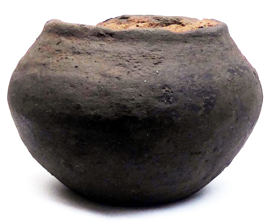
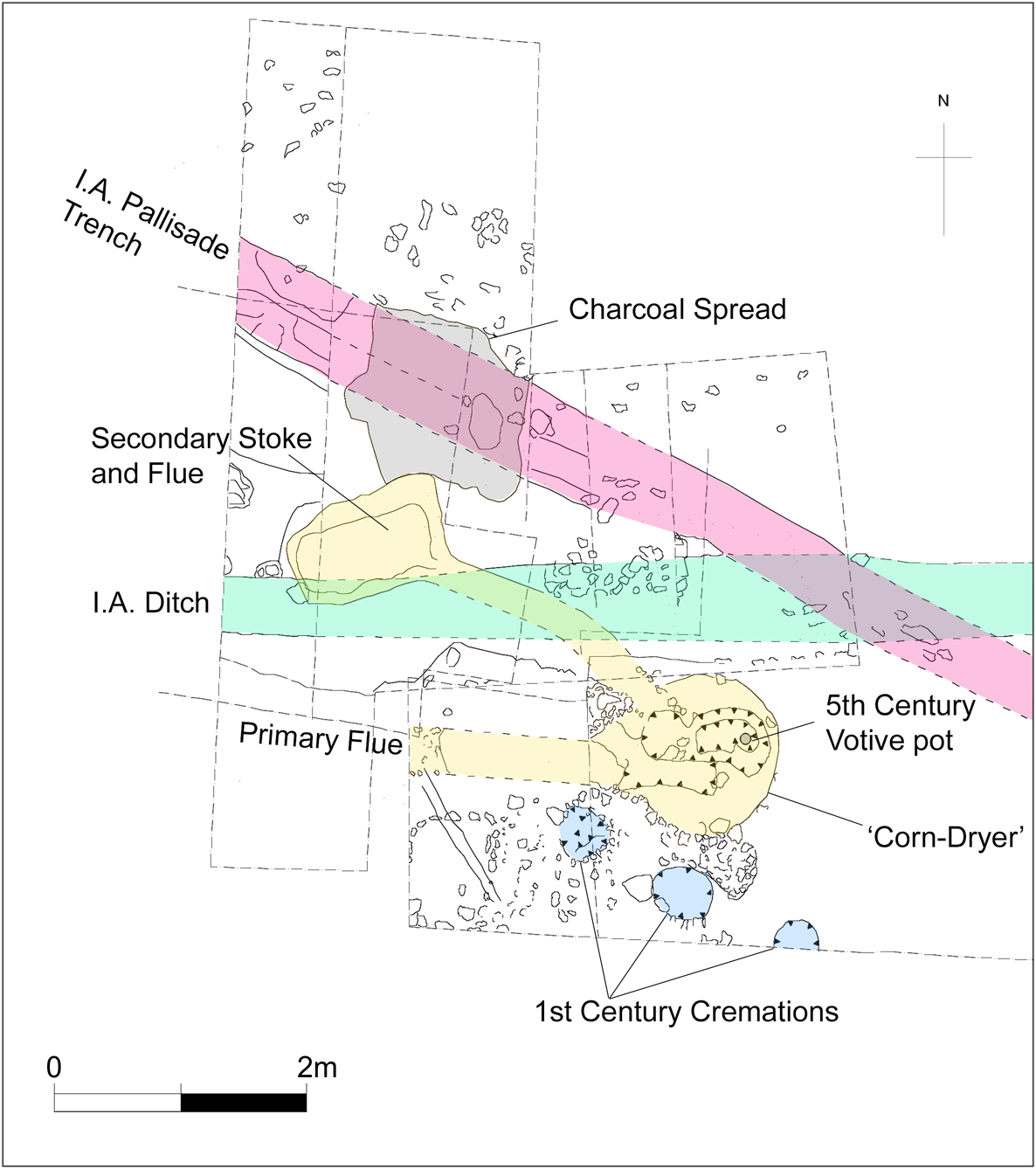
(3) East Farleigh, land at Gallants Farm, Lower Road (TQ 72850, 53550): a corn-dryer feature was found, with a fifth-century votive vessel deposit buried beneath the chamber (fig. 27) and with a second replacement flue.Footnote 167 Three first-century cremation burials were found with grave goods (fig. 28).
East Farleigh: fifth-century vessel used as a votive cessation deposit in a ‘corn-dryer’.

East Farleigh: partial trench plan showing features.

WEST SUSSEX
(1) Chichester, 4 Velyn Avenue (SU 86687 04695): a watching-brief revealed activity likely to represent part of the tail of the nearby amphitheatre earthworks. Six sherds of Dressel 20 amphorae and a fragment of a rotary quernstone were recovered and dated to the first to second century.Footnote 168
(2) Lancing, New Monks Farm (TQ 1904 0527): evaluation revealed a significant number of archaeological features, including ditches, gullies and pits. These features suggest activity during the Roman period, with the features in the western part of the site indicating the presence of a settlement.Footnote 169
SUPPLEMENTARY MATERIAL
For supplementary material for this article please visit https://doi.org/10.1017/S0068113X20000471