Introduction
The amount of data in agriculture is increasing rapidly. Farm Management Information Systems (FMIS) have been advocated and developed to help growers with this information. However, over the past decade the industry has seen a boom in data availability – manufacturers now routinely build data systems into machinery/equipment, production systems have increasing levels of internet connectivity and agro-tech solutions are proliferating. Additionally, more and more off-farm information is also becoming accessible to potentially assist with on-farm decision e.g. weather services, market information and external production records. Farmers are familiar with the farm fields, crop seasons, pests and the effect the environment has on the farm, most do not have the capital or the manpower to process all these new and emerging data. The level of information is now at a stage where growers increasingly rely on service providers to process and deliver information. This has created a shift in agronomic service provision that must now deliver on data mining and Big Agricultural Data analytics. This shift should simplify the amount of information that the grower has to interact with to make a decision, however it places more of a burden on service providers.
It can be expected that Precision Agriculture (PA) will continue to grow rapidly as data becomes cheaper to store and easier to transfer, making Big Ag Data more significant for farm service providers to provide quality services with relevant information for the farm managers. As data evolves, it is critical that the information systems also evolve to accommodate these new data. In the last few years, PA has seen rapid technological development introducing radical changes to the working environment, agriculture has entered a new era, where accessing relevant and timely data will improve the decision making for the farm manager. The basis for enhanced decision making relies on correct quality data, however the current situation in European farming is that most of the sources of data are dispersed, difficult and time consuming, minimizing the full potential of the data available; integrating spatial and temporal historic data, real time farm data, knowledge sources, statutory compliance, health and safety, environment guidelines, economic models, etc, into a coherent management information system expecting to remedy this situation (Fountas et al., Reference Fountas, Carli, Sørensen, Tsiropoulos, Cavalaris, Vatsanidou, Liakos, Canavari, Wiebensohn and Tisserye2015)
In this paper, issues with Precision Agriculture information management systems for service providers, as opposed to growers and FMIS, will be explicitly addressed. A new conceptual information system -Ag Service Provider Information System (ASPIS) - will be proposed that extends current FMIS capabilities. The proposed ASPIS will be discussed in the context of emerging Ag Data sets and the types and methods of delivery of Ag Data into service providers; the hardware and software needs to run this new model; and outline the types of services that need to be developed within the ASPIS for effective use.
Farm Management Information Systems
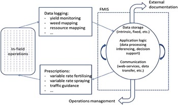
Farm Management Information Systems aim to provide relevant valuable farm information to support the making of management decisions on farm operations (Sørensen et al., Reference Sørensen, Pesonen, Bochtis, Vougioukas and Suomi2010). The first FMIS was introduced in the 1970 s, dealing with record keeping and operation planning consisting of four major components: data processing that seldom change, cropping season, daily farm operations and inventory data (Blackie, Reference Blackie1976). These early FMIS operated largely without spatial applications; the advance in PA Technologies and data connectivity in the 1990s and 2000s has created the need to design dedicated Precision Agriculture FMIS (Fig. 1) to cope with the increased amount of spatial data in modern agriculture (Nikkilä et al., Reference Nikkilä, Seilonen and Koskinen2010).
Schematic illustration of a Farm Management Information Systems. (Fountas et al., Reference Fountas, Carli, Sørensen, Tsiropoulos, Cavalaris, Vatsanidou, Liakos, Canavari, Wiebensohn and Tisserye2015).

FMIS to date have been characterized by:
-
∙ Mainly desktop Applications
-
∙ Providing service to one farm enterprise, the main data processing is in the local computer(s)
-
∙ Data processing and management is local with networks capabilities to download and transfer files
-
∙ The need to be updated regularly
-
∙ Data is not shared
-
∙ Data analysis is limited to the local machine and user capabilities
Ag Service Provider Information Systems
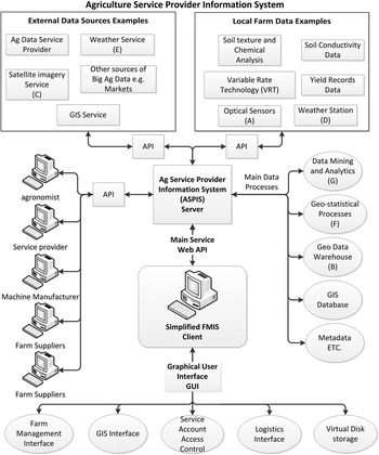
As the type and amount of data changes, the information systems to manage the data also need to change. Ag Service Providers Information Systems (ASPIS) is a new conceptual agricultural information system (Fig. 2) delivered as an internet web service, consisting of a Server(s) and
Schematic of a potential Ag Service Provider Information System.

simplified FMIS services delivered as a web application (Client). It is delivered from a server(s) and data centre to provide a variety of services to the farm industry, such as web-based farm data visualisation, data analytics, growing season modelling, field satellite images, localize field weather information, etc. In addition they can provide Big Ag Data analytics and services to Agriculture stakeholders to better serve the industry, including other agricultural service providers.
ASPIS are flexible and adaptable and should be capable of supplying multiple levels and types of services. There is no geographic restriction such that a well specified ASPIS could potentially deliver relevant services to small and medium farms worldwide. The possibility to service a number of different countries with locally specified services will overcome some of the distribution limitations common with FMIS because of language or culture differences. The service provider would be able to deliver a customized web interface determined by geographic area, country and determine the relevant information the local user needs. Delivering a farm management information service(s) via this ASPIS model could be a significant tool to help develop agriculture in countries where Precision Agriculture has been limited because of low availability in the local agriculture community. While FMIS are targeted only at the producer (end-user) grower, ASPIS could be developed to directly support producers or to indirectly support producers by providing support to other agricultural service providers, such as agronomists.
ASPIS are characterized by:
-
∙ ASPIS is distributed where the farm is a client of a Web service hosted in the internet
-
∙ Internet applications able to be displayed in PCs, tablet and mobile devices
-
∙ Data is distributed and storage method is transparent to users
-
∙ Data is stored remotely or locally
-
∙ Services can be delivered by demand or subscription
-
∙ Data is shared
-
∙ Geographic Information Systems are delivered as a service
-
∙ Data warehouses with big process capabilities to process, analyse and deliver Big Ag Data
FMIS versus ASPIS
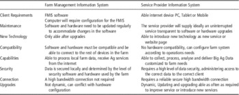
Figures 1 and 2 visually illustrate the conceptual differences in data sourcing, data analytics and decision processes between a traditional FMIS and an ASPIS. Table 1 summaries the key points of difference between the two systems.
A comparison of key functionality of Farm Management Information Systems versus Service Providers Information Systems

Ag Data delivery to the Grower
From the point of view of an Ag Service Provider, agricultural data comes from two sources:
-
∙ Data produced on the farm which is sent to the server to be stored, processed/analysed.
-
∙ Data that comes from external sources such as financial markets, environmental agencies, government departments and other agriculture stakeholders.
Big Data is a term to define datasets that are larger or more complex than traditional data; they may be analysed computationally to find patterns, trends and associations. Particular to Big Data in Agriculture we find for example; satellite images that are several megabytes in size, spatial data from on-the-go soil sensor with thousands of data collected in every survey or a weather station that collects multiple weather data every minute of the day creating 43.920 datasets per month.
The Ag service provider would be able to collect data produced by the farm devices to be stored, analysed and delivered in ways that the information is easy to understand and relevant to take decisions timely and efficiently. The application would be delivered in a web application with web pages to visualise and manage the farm information. The farm could benefit from the service in cases of damage or failure, for example if the farm’s weather station stops working, it would be very easy to get weather information from the ASPIS available from other stations in the same area, or if the N sensor fails the farm could use satellite imagery or a N fertilization VRT prescription map from satellite data.
AG Service Provider Information Systems would be able to collect all relevant Ag data to be delivered as services to the farm on a daily basis. The main purpose is to deliver high quality Ag data through an easy to use web site interface. This service would be highly dynamic and customized to the needs of the farm and its management, with feedback from the customers the web service could be updated. Web applications can be updated easier than desktop applications therefore able to provide a more dynamic and modular application.
Agricultural Data Connectivity
The Ag industry is taking advantage of the latest development in web services and mobile technology; most manufactures are using communication technology to support their customers, improve their services to farmers and in some cases increase sales and public relations. Application Programming Interfaces (APIs: In computer programming, an application programming interface (API) is a set of subroutine definitions, protocols, and tools for building software and applications.) permit third party users to potentially access these data and a key advantage to the ASPIS approach is flexibility in bringing disparate data sources together to make more informed decisions. Of course to be effective, the Ag Data Service Providers must provide and decide which APIs they will implement and offer. Similarly, it is also possible to use other web service platforms (e.g. RESTful Services or other HTTP base services: Representational state transfer (REST) or RESTful web services are one way of providing interoperability between computer systems on the Internet. REST-compliant web services allow requesting systems to access and manipulate textual representations of web resources using a uniform and predefined set of stateless operations.) to deliver data/information to the ASPIS and to the simplified FMIS interface, all with the aim of better decision-making (Pautasso, Reference Pautasso2013).
Data and information transmission is not restricted to downstream activities (internet →farm). On farm metrology is common and increasing, particularly with the potential to collect data using mobile technology and applications. This opens the possibility to collect data from the field and wirelessly transfer data to cloud services, agronomic services and stakeholders to manage the farm assets and fields, i.e. upstream data flow (farm→internet). This provides the ASPIS, and the operator(s) and users of the ASPIS, with a lot more potential power than a traditional FMIS. This will assume greater significance with the introduction of super-fast mobile broadband in rural areas and large area Wi-Fi networks that could cover entire production systems. When these are available, farm equipment and operations could be integrated into the Internet of (Agro) Things and management decisions driven through IoT infrastructure, of which the ASPIS will be an example key component. However, while IoT will facilitate an ASPIS approach, it is not mandatory for successful implementation. There is sufficient connectivity at the moment to implement an ASPIS platform
Agricultural Service Provider Information Systems Technical Requirements
There are technical as well as operational/management constraints on how an ASPIS could and should be implemented in the industry. The key issues are:
-
1. Internet Access: The service provider must deliver a reliable service with high bandwidth super-fast broadband able to support thousands of requests and high demands of data from GIS applications. The clients must have an able internet connection and web browser, rural bandwidth in Europe is variable dependent of the country and could be an obstacle for the delivery of the service across the continent. In the United Kingdom the coverage of high bandwidth has been improved in the last few years.
-
2. Scalability: Refers to the ability to handle growth in software or hardware without affecting the service quality or function when moved from a small operating system to a bigger one taking full advantage of the new capabilities. Today web server systems are highly scalable and designed to handle peak increase of internet requests per second.
-
3. High Availability: The ability to function continually for a desired length of time. It is measured against a 100% function or the five 9s (99.999%), much of the planning for high availability is around backup and maintenance of the system. For large internet services it is desirable for users to be unaware of backup, maintenance or other related issues providing a high level of service to all the clients.
-
4. Usability: The main issue of usability is to make the human user interface as intuitive as possible, simple to use and with minimal training necessary. It should supply a high level of support for the client and collect user’s feedback to fulfil and maintain an excellent level of service. It should support customization of the webpages for the user to choose the settings most suitable for them. The spatial display of data in the web GIS should be easy to understand and use, avoiding the use of complex equations or statistics; this could be displayed in a user friendly way if possible or translated to graphic interpretations of the data.
These technical requirements will limit delivery in many locations in the short-term. However, remarkable progress is being made in all of the areas above and it is easily foreseeable that rural enterprises in the near future will have the same level of connectivity as modern-day urban businesses.
Types of Services
In Figure 2 there are potential Service types indicated. These will include (but are not limited to) services that provide:
-
∙ Farm Management Interface: This would include all the services concerning management of the farm financially, also staffing, marketing, legislative, accounting, etc.
-
∙ Geographic Information System and Spatial Analytics Interface: This would be delivered as a GIS system where maps and spatial data will be visual.
-
∙ Account Management and Access control: This would deal with the management of the service provider account.
-
∙ Logistics Interface: This would manage the equipment, job schedule and status.
-
∙ Agronomic Management Interface: This would manage all the agronomic activities and status of the fields.
-
∙ Data storage and retrieval: This would operate as virtual hard disk for the use of the farm.
Case Study
A simple case study illustrating the power of the ASPIS is presented using variable-rate first nitrogen application in a cereal crop as an example agronomic service. [NB. The alpha characters in the following text link to Fig. 2] Early season scanning with an optical multi-spectral sensor during crop protection practise provides crop vigour [A] that is uploaded to the geodatabase [B] in the ASPIS. Satellite or other remote-sensing information may also be available to supplement this [C]. Local weather information is sourced from a telemetric on-farm weather station [D] to assess local conditions for operations and thermal crop time to date. This is supplemented with short range (15 day) forecasts from on-line weather systems [E]. This weather and crop information can be used to model phenological development [F] and for expected yield (production) given actual and predicted weather patterns. This information can then be linked spatially to other similar growers in the area to ‘benchmark’ production conditions [G]. Information on target markets for production can be assessed and market or production targets adjusted accordingly. This information are used to provide a spatial prescription map for nitrogen application to suit production targets. This will also include advice on timing of application and risks associated with misapplication based on current conditions and imminent weather conditions. The grower is able to review and iterate this suggested prescription map. This information can then be fed forward to the operator to perform the fertilisation. The ASPIS can also inform suppliers of input requirements and ensure that the grower has sufficient and timely access to inputs. The final decision and the actual application (which may differ) can be recorded, stored and shared with the relevant actors e.g. the grower’s agronomist, through the ASPIS. This firstly provides an auditing tool to ensure management is performed correctly but facilitates the use of historical management practices to inform decision making on subsequent management. All this can be done in real-time or near real-time. In addition, adjustments made by the grower can feedback to the ASPIS as a learning tool for future advice, either directly on farm or as diffuse information for other growers. For example, favourable seasonal weather conditions may dictate a shift from low to high quality production potential, but if everyone shifts then there is a risk of lower prices with oversupply. With sufficient regional/national information being collected, this risk could be modelled and/or factored into decision making using data analytics.
This is just one theoretical example of a potential service, but the advantages of a more integrated information can be clearly seen. It is a more robust system. In the case of failure of local devices such as the canopy optical sensor or weather station, the ASPIS could source a similar services such as satellite imagery or weather information from nearby or virtual weather stations in the area. Within a traditional FMIS, lost data will cause a failure of the system. It also opens many more possibilities for data analytics to inform management. A larger interoperable crop phenology database within the ASPIS will facilitate better crop modelling and remove some of the onus on individual growers to comprehensively populated databases to run models. Market and supply decisions can be made with informed industry activity fed in from multiple enterprises rather than on speculation.
Conclusions
Agricultural Service Provider Iinformation Systems could supply an array of services at different levels, for the farm they could supply excellent services incrementing the functionality and usability for the benefit of farm productivity, also could facilitate a more efficient farm management and customise services to the farm needs. The case study illustrates advantages of having information systems predominantly determined by Ag service providers integrating ‘big ag data’ and devolving potential decision systems to growers. There are however some inherent risks to this approach, especially for growers. The largest risk concerns the sharing of farm-specific data, as farm information is shared virtually on the internet and potentially used for a myriad of uses that are external to any one enterprise. This is a fundamental shift in data control away from the grower with near complete control on local desktop system, to data control by a third party (industry actor in a virtual, cloud environmental). Of course, any service that has concerns with sharing of information must have strict access controls and implement the latest internet security and encryption to protect the user’s data, however, the foremost question is really one of data access. Data is powerful, especially when aggregated, growers should be fully aware of how their data may be used in any service generated by the ASPIS and control of whether it is available or not; the farm management team should have full control over data access. This of course may affect how they can profit from access to other enterprise data.
Acknowledgements
This project was funded by Innovate UK through the Knowledge Transfer Partnership scheme.