

INTRODUCTION
As Assistant Chief of the United States Soil Conservation Service under Hugh Hammond Bennett, Walter C. Lowdermilk (1888–1974) gained worldwide recognition in the wake of the Dust Bowl of the mid-1930s as a leading evangelist of the gospel of soil conservation.Footnote 1 A decade earlier, while in China, Lowdermilk conducted field research on the influence of deforestation on streamflow and erosion that established his authority as one of the founders of the “scientific basis” of soil conservation.Footnote 2 “It was in China,” he later recalled, “that the full and fateful significance of soil erosion was first burned into my consciousness.”Footnote 3 In light of the “tragic scenes on a gigantic scale” that he witnessed there, Lowdermilk “resolved to run down the nature of soil erosion, which had proved to be the insidious enemy of civilization” and devoted his life to studying “ways to conserve the lands on which mankind depends.”Footnote 4
Lowdermilk was one in a cohort of American experts (including his colleague at the University of Nanking, John Lossing Buck) who ventured to China in the early twentieth century to impart the “universal truths” of agronomy, forestry, soil science, and agricultural economics.Footnote 5 This article examines collaborations between these American experts and their Chinese counterparts in the transmission and generation of knowledge about nature to show how, as Ian Tyrrell has observed, during the early twentieth century “the transnational context of American conservation was not European or Atlantic but global.”Footnote 6 Like the British naturalists studied by Fa-ti Fan and the Euro-American botanical explorers examined by Erik Mueggler, research that Lowdermilk and other American agricultural experts conducted in China depended heavily on Chinese co-workers, though the Chinese role has gone unrecognized in existing scholarship.Footnote 7 By focusing on two-way interactions between Chinese and foreign actors in efforts to explain, study, and represent China's environment, this article adds to recent historiography that has recast China's twentieth-century encounter with modern science as one of active appropriation, translation, and innovation rather than passive Chinese reception.Footnote 8
Lowdermilk's 1920s field studies in North China's Shanxi province depended upon knowledge, connections, and guidance provided by his student and colleague, Ren Chengtong (1898–1973), which enabled him to utilize local information networks and patronage systems. As a mediator in this Sino-foreign encounter, Ren Chengtong exemplified the type of “people in between” who, as historians of science have shown, keep knowledge flowing through networks of circulation and production that cross localities, regions, and nations.Footnote 9 Lowdermilk's field notebooks and his published and unpublished writings, when read alongside Ren's published articles, afford insight into the terms of their collaboration, how they gathered information and produced knowledge about deforestation and soil erosion, and the significance they attached to their research.
Local assistants have been so ubiquitous and essential in the field sciences that, as Jeremy Vetter writes, “Hardly any expedition, survey, station, or other enterprise could be effective without them.”Footnote 10 Ren fit into this category in certain ways, but he was not a typical local informant. Although he was a native of Shanxi and possessed direct knowledge of the field sites where he and Lowdermilk conducted their research, his training and education taught him to perceive environments in terms of scientific categories and methods. Framed in the typology devised by Robert E. Kohler, Ren combined the “cosmopolitan” knowledge of modern science with the “residential” ways of knowing characteristic of a locale's inhabitants.Footnote 11 By joining cosmopolitan expertise and residential knowledge in a single role, Ren made possible a mode of scientific practice that utilized in-depth local knowledge to buttress its claims. Yet unlike Lowdermilk, who drew upon field studies carried out in North China to validate what he viewed as universalizing scientific principles, Ren deployed the knowledge this research produced to pursue China's goal of national self-strengthening.
In addition to identifying field sites in Shanxi and giving Lowdermilk access to local connections, Ren was instrumental in securing official support for their fieldwork. Despite the political turbulence and fragmentation that prevailed in China during the 1920s, a strong connection existed, as it has in many other contexts, between field science and state power.Footnote 12 Yan Xishan, the warlord who controlled Shanxi province, backed their studies as part of his drive to improve management and control of woodlands and other natural resources that could be exploited for state-building and economic development. Lowdermilk and Ren's diagnosis of deforestation, soil erosion, and their consequences, in turn, replicated key elements of what Karl Jacoby terms the “degradation discourse” of early twentieth-century conservation: a rural populace engaged in unwise environmental practices that would result in ecological doom unless natural resources came under the oversight of scientifically trained experts employed by the modern administrative state.Footnote 13 Like other conservationists, Lowdermilk and Ren idealized scientific expertise, a rhetorical emphasis on the greater good, and the goal of making the environment productive with minimum waste.Footnote 14 These principles appealed to early twentieth-century Chinese elites like Ren and Yan Xishan precisely because, as Tyrrell observes of progressive-era conservation in the United States, the desire for efficiency went hand in hand with an “urge for a stronger state to compete on the international stage.”Footnote 15
STREAMFLOW STUDIES ON THE SLOPES OF SHANXI
Lowdermilk took an unexpected path to China. Upon graduating from the University of Arizona he won a Rhodes scholarship at Oxford in 1912, traveling between terms to study forestry in Germany. After participating in the Commission for Relief in Belgium during World War I, he returned to the United States and started a career in the Forest Service.Footnote 16 But in 1922, Lowdermilk became engaged to Inez Marks, a family acquaintance who had just returned from Methodist missionary work in China's Sichuan province, and she persuaded him to secure a position at the School of Agriculture and Forestry at the University of Nanking (Jinling daxue) so they could go to China together. Arriving in Nanjing only months after the North China famine of 1920–1921, Lowdermilk lent his forestry expertise to famine prevention programs backed by international relief funds under the university's management.Footnote 17 To this end, he set about conducting regional studies of “the relationships of forestry to floods and famines” and how tree planting and forest management programs could “contribute to the control of floods and to the industrial and economic improvement of the populations in regions of high famine hazard.”Footnote 18
Early in the century these questions had generated enormous controversy in the United States. Debates surrounding the Weeks Act of 1911, which empowered the federal government to purchase land to protect forests in the watersheds of navigable streams, centered on the effects of forest cover on streamflow. In pressing for its passage, members of the United States Forest Service (Lowdermilk's old employer) argued that deforestation radically affected runoff and streamflow, which increased the level and frequency of flooding, accelerated soil erosion, and decreased precipitation. The Act's opponents, especially in the Army Corps of Engineers, attacked foresters for their reliance on qualitative observation, noting that no experiments had quantitatively compared streamflow in forested and deforested watersheds.Footnote 19 Seeking to fill this lacuna and counter the engineers’ criticisms, from 1924–1926 Lowdermilk launched an experimental program to measure and compare absorption of rainwaters on inclined lands with and without forest cover. He and a team of Chinese colleagues and students from the University of Nanking obtained this quantitative data through field studies conducted in various Shanxi watersheds.Footnote 20
MOUNTAINS DRAINED DRY
In October 1926, Lowdermilk presented findings from this research in Tokyo at the Third Pan-Pacific Science Congress. Measurements from experimental plots showed that runoff from slopes that were denuded for cultivation greatly exceeded runoff from land with forest and shrub growth. Surface runoff of rainwater, he asserted, was “waste” in semi-arid regions (like North China) with moderate or low rainfall. Rapidly accumulating runoff produced “torrential flows of storm water” that cut deep gullies into hillsides and stripped land of “productive and absorptive soil layers.” Soil erosion on slopes “far above the normal, or above what would occur if the vegetative cover of the pre-human era had remained unmodified,” represented “the most outstanding feature of the physiographic processes at work.”Footnote 21
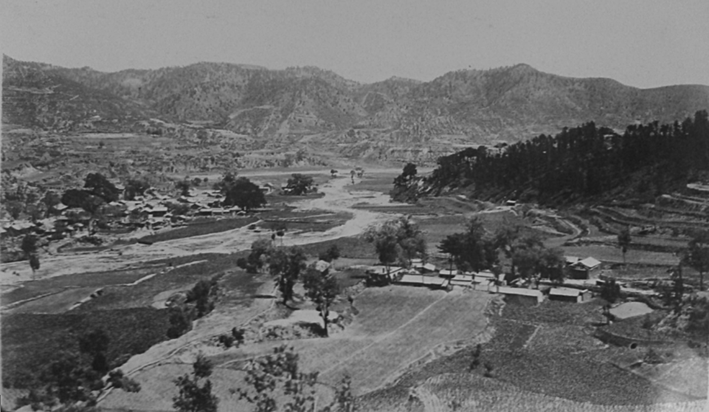
General view of Qinyuan study area, Province of Shanxi, China: “Showing the temple forest on the right and general denudation of forest vegetation elsewhere. Surficial run-off plots were located within the temple forest and on a homologous slope in the drainage shown in the left of the photograph.” Walter C. Lowdermilk Papers, Hoover Institution Archives, box 9.

Like the research of other early twentieth-century field scientists, that which Lowdermilk conducted with his Chinese colleagues created a “labscape” that brought elements of the laboratory—its instruments, experimental protocols, and quantitative precision—into the field.Footnote 22 Employing the “run-off plot method,” they set up specially designed sample plots on adjacent sites with contrasting levels of vegetation cover.Footnote 23 Rain that fell in the plots could only escape through an opening that led into a measuring device. Self-recording tipping buckets measured runoff volumes, and rain gauges determined the amount of rain that had fallen. The proportion of rainfall that escaped as surface runoff was determined for each storm, making it possible to systematically compare individual plots. Runoff measures from lands with equal gradients indicated that rainfall scarcely affected those with vegetation cover but created torrents on denuded slopes.Footnote 24
Lowdermilk's runoff studies produced knowledge based in place, inextricably tied to the slopes in Shanxi. But like other field scientists, his arguments attempted to achieve greater scope for the knowledge generated by making claims that moved to higher levels of territorial scale.Footnote 25 Even as his runoff plots produced quantitative data on the relationship between forests and streamflow, he interpreted these data based on historical assumptions and observations made during expeditions in Shanxi. Processes that had “been at work for centuries in destroying the former vegetation cover of the province,” Lowdermilk believed, were observable in all his field sites. Farmers had cleared forests to cultivate soils for food production, digging up “rich vegetable soil” to grow cereal and potato crops. Due to annual monsoons, precipitation in Shanxi was uneven, falling mostly in summer as short but intense thunderstorms. With land exposed to rainstorms, torrents removed soil, gravel, and boulders and transported them to the plains below, covering fertile valleys and rendering them “sterile.” Shanxi's topography, 90 percent of which consisted of slopes with gradients averaging 20 degrees or higher, was especially prone to this type of erosion.Footnote 26 Widespread slope cultivation and use of vegetation for fuel, “even to the digging up of roots,” reduced the land's capacity to absorb rainwater, decreasing moisture supplies available for vegetation. As Lowdermilk put it, “Slopes have been dismantled of productive soil layers; mountains have been laid bare.” These processes operated “over an enormous extent of North China” and had “intensified in the past three centuries in response to a marked increase in population.”Footnote 27
But this degraded condition had not always prevailed. In twenty Buddhist and Daoist temples that Lowdermilk visited in North China, “the arboreal and shrub vegetation was generally found reproducing itself naturally.” These conditions contrasted sharply with otherwise similar slopes that had been stripped of vegetation and soil, which were “washed away or cut through with enormous labyrinths of gullies.”Footnote 28 As Marcus Hall observes, it is questionable whether forests in carefully maintained temple landscapes offered a glimpse of the “original” environmental conditions prior to human habitation. Yet Lowdermilk used these temple forests as a baseline for gauging the extent to which the surrounding landscape had been degraded.Footnote 29
In this manner, Lowdermilk crafted a classic narrative of ecological decline. Slope cultivation had proceeded from the plains to the highest mountains throughout North China. For the past century, perhaps longer, the “natural cover of vegetation of shrubs and forests” had been removed to cultivate “the deep vegetable and fertile soils to which the cover of vegetation had given rise.” Hence, “the slopes over hundreds of thousands of square miles” were “dismantled of their deep absorptive soil layers and left thin, rocky and arid.”Footnote 30 Accelerated soil erosion, he claimed, had also changed North China's climate. Since cultivation reduced the capacity of inclined land to absorb rainfall, denudation increased surface runoff above levels that prevailed in “the prehuman period,” decreasing the amount of water returned to the air via evaporation and transpiration. Over a prolonged period, this “had a significant influence” in reducing aggregate rainfall.Footnote 31 Lowdermilk estimated that these processes affected 40–60 percent of the uplands in northern China, so, “The mountain masses have literally been drained arid.” For this reason, he considered “[w]ater and soil reclamation” the most important task in restoring the “denuded and dismantled mountains” and increasing the region's productivity.Footnote 32
Lowdermilk was correct in his assertion that the vestiges of forest in North China's hills and mountains had suffered damage during the Ming (1368–1644) and Qing (1644–1911) periods. Likewise, we have no reason to doubt that this deforestation increased runoff and erosion on the steep slopes where he conducted his research.Footnote 33 But the narrative of environmental decline within which he framed these findings reiterated what Saberwal terms a “desiccationist discourse” based on unsubstantiated and simplistic claims about the consequences of deforestation.Footnote 34 The relations among deforestation, runoff, and desiccation that Lowdermilk postulated oversimplified the complex ecological processes that influence surface flows of water and soil. Furthermore, the evidence he derived from small plots established on a few slopes in Shanxi was of questionable applicability when transposed to larger spatial scales such as watersheds or entire regions and used to explain historical change.Footnote 35
THE SHANXI CONNECTION: REN CHENGTONG AND YAN XISHAN
Lowdermilk based his conclusions on runoff studies conducted at three sites in Shanxi. One was in Congziyu, a remote village in Shanxi's Qinyuan county at the headwaters of the Qin River, which drained most of southeast Shanxi's “dissected highland.” Qinyuan was mostly cultivated, though small, isolated forests existed where “communal effort” preserved them. Lowdermilk estimated that barren slopes, with evidence of former cultivation, covered 40 percent of the landscape around the field site. Trees returned only slowly to this abandoned land since sheep and goat grazing kept vegetation thin. Lowdermilk and his Chinese co-workers set up one sample plot in a village forest in Congziyu and another on a nearby denuded slope. Runoff studies measured twenty-three storms over eighteen days, totaling 307 millimeters of rain, which mostly fell as sudden thunderstorms. They found no erosion taking place in the forest, in sharp contrast to heavy runoff on slopes without forest and shrub growth.Footnote 36
The runoff plots in Qinyuan were overseen by Ren Chengtong, an alumnus of the University of Nanking's School of Agriculture and Forestry, who joined the faculty after graduating in 1923.Footnote 37 Born in northern Shanxi's Xin county in 1898, Ren attended Xinzhou Middle School (Xinzhou zhongxue) until 1918, when he gained admission to the preparatory course at Shanxi University (Shanxi daxue) in the province's capital of Taiyuan. During the May Fourth Movement of 1919, in which urban intellectuals and students across China protested foreign imperialism, Ren participated in patriotic activism that swept Shanxi University. In keeping with the May Fourth ethos of strengthening China by promoting a “new culture” of rational and scientific thought, he devoutly believed in “science to save the nation” and pursued scientific training to “render service to the homeland.” In 1920, he entered the University of Nanking on a scholarship from Shanxi's provincial government.Footnote 38
Ren's studies benefited from the support of Shanxi's provincial warlord, Yan Xishan, who hailed from the same region of Shanxi as Ren and had recently initiated forestry administration reforms in the province. Soon after the Republic of China was founded in 1912 the country descended into a period of political fragmentation in which many provinces became virtually independent states. In these circumstances, state-building in China assumed a regionalized character. As part of his state-building efforts in Shanxi, Yan launched province-wide afforestation and forest management campaigns. State-building required access to wood, which in turn required forestry policies and afforestation plans. After 1916, as Shanxi's military and civilian governor, Yan mobilized the populace to plant and cultivate trees, enacted forestry legislation, and utilized state power to enforce regulations. Tree planting and afforestation became province-wide priorities as part of Yan's “Six Policies and Three Matters” (liu zheng san shi) campaign (1917–1922). Village headmen in Shanxi explained forestry policies and directives to local people and oversaw their implementation.Footnote 39 For Yan and other political leaders in China during the Republican period (1911–1949), as Elena Songster observes, “Trees provided the basic components for attaining most of the material elements of early twentieth-century visions of a new China and the material means for operating and protecting a new state.”Footnote 40 Yan looked to Ren Chengtong and other scientifically trained experts to support him in realizing these aspirations.
At the University of Nanking Ren worked closely with Lowdermilk and emerged as a star pupil. He spent the summers of 1922 and 1923 traveling from Nanjing to his native place in northern Shanxi, investigating forests and erosion conditions along the way. Upon his return to the university, Ren wrote a report that earned high praise from Lowdermilk, who arranged for him to graduate early and stay on as an instructor.Footnote 41 In 1924, Lowdermilk enlisted Ren to participate in his runoff studies in Shanxi. All the field sites where research took place had been first scouted by Ren the previous summer.Footnote 42 Lowdermilk later claimed that Chinese colleagues hesitated to go “out into the field” because they viewed manual work as beneath their dignity as scholars.Footnote 43 Yet on their expeditions in Shanxi's rugged countryside Ren acted as guide and took care of their research materials.Footnote 44 Lowdermilk selected survey locations based on Ren's earlier fieldwork, while Yan Xishan lent assistance by sending police to protect their research installations.Footnote 45
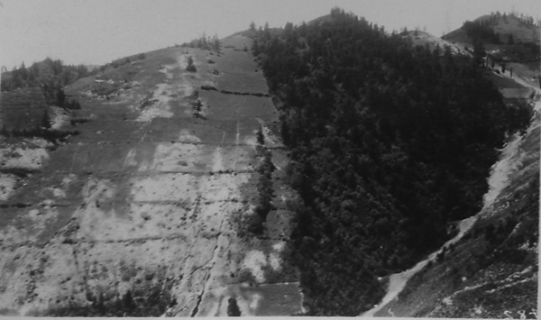
Dongzhai study area: “‘Contrast Valley,’ showing a remnant of the former natural forest and shrub vegetation and the results of slope cultivation. Superficial run-off plots in pairs were located within the forest and on two phases of the cultivated and denuded portion of the slope.” Walter C. Lowdermilk Papers, Hoover Institution Archives, box 9.

THE FOREST, THE VILLAGE, AND THE STATE
Ren and Lowdermilk ascribed different meanings to the places where they conducted their field research. For Lowdermilk, Congziyu's isolated village forests offered ideal sites for measuring the effect of deforestation on streamflow. Ren, on the other hand, in his own writings cast his knowledge of the local regulations that governed village forests where they conducted their field studies as a blueprint for a modern system of conservation. In this manner, Ren reinvented local environmental practices as a form of scientific, state-centered resource management. Lowdermilk in his writings made no mention of these regulations.
These forests, Ren explained, were “common property” (gonggong chanye) of village temple associations (cun she), which used income gained from them to undertake “common enterprises.”Footnote 46 Throughout the nation, he pointed out, wood for construction and fuel was scarce, and prices were rising. Yet barren mountains existed everywhere. When trees grew due to natural propagation, “People who seek petty profits can never wait for small trees to grow, and always cut them down for their kitchen fires.” To Ren, village forests offered a model for eliminating these malpractices: “Because village-owned forests are public property, they are mutually supervised, everyone takes responsibility for protecting them, and they cannot freely dispose of them.”Footnote 47 By the 1920s, Qinyuan's once expansive forests had become sparse and fragmented. This change occurred, Ren argued, because most forests were privately owned. Mountain owners (shanzhu) who “coveted petty profits” deemed the selling price of trees too low. But decaying leaves made forest soils fertile, so landowners cleared trees on slopes to plant oats. “Originally, they wanted to gain more income, but they did not expect that after they had cut down the trees the soil on the slopes could not be retained.” Rainfall washed away the soil, leaving “piece upon piece of bare, rocky slopes.”Footnote 48
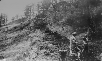
Dongzhai area: “The process of forest destruction and slope denudation under way. The forest is on the right; in the center are mountain farmers digging up the deep soil to expose it to a new regime of erosion; and to the left is a stump filled oat field as a result of the former year's clearing.” Walter C. Lowdermilk Papers, Hoover Institution Archives, box 9.

By the 1920s, Qinyuan's “scattered fragments of forest” were village-owned; most privately owned forests turned into barren mountains. This difference, Ren held, demonstrated the superiority of village-owned forests (cunyou lin). Checking erosion was not the only benefit. Along with eliminating damage to fields, village management could “directly conserve forests as a long-term source of profits.”Footnote 49 Despite being a remote village with only eighty-five households, Congziyu boasted primary schools for boys and girls, which Yan Xishan promoted in Shanxi to fight illiteracy, disseminate his political message, and instill proper attitudes and virtues in the common people. Forests funded schools, which in turn strengthened the state.Footnote 50 While many more affluent villages lacked primary schools, Congziyu could open these educational institutions thanks to “income from these mountain forests.”Footnote 51 To promote primary schooling and state-strengthening, Ren offered a detailed description of Qinyuan's village-owned forests for other locales to emulate.
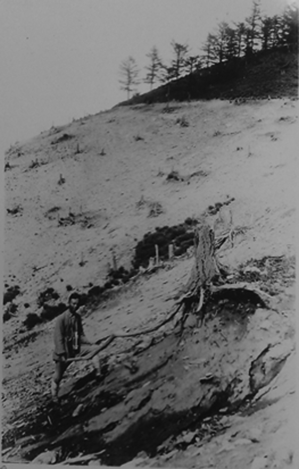
Dongzhai: “The result of slope of farming; soil to a depth of fully two feet was washed away, as may be judged by the former buried roots. Here the geologic norm of erosion has been accelerated at a tremendous rate. No evident surface erosion is visible in the area at the top of the photograph where the soil has not been cultivated.” Walter C. Lowdermilk Papers, Hoover Institution Archives, box 9.

Much as other temple complexes in other Shanxi villages held power over distribution of water from irrigation systems, during the Qing period ritual networks centered on local village temples oversaw access to communal forests.Footnote 52 In Congziyu's Dragon God Temple, Ren came across a stele inscription from 1856 that recorded the forest's history, which he transcribed in full. Migrants came to Congziyu and constructed the temple in the mid-1500s, and in the 1850s the villagers gathered and agreed to refurbish it. “Moreover,” read the inscription, “villagers publicly resolved that the temple forest, which the ancestors bequeathed for public use for repairing the temple and for the needs of households, kinship groups, and other persons in repairing buildings and to cut as eaves, was the ancestors’ kind intention.” However, “lawless people” did not abide by “ancient rules” and wantonly cut trees to make profits. Hence, villagers placed prohibitions on trees at a prescribed distance from the temple, indicating that “unless it is for public use in repairing the temple, none of them may be cut.”Footnote 53
In the late nineteenth and early twentieth centuries, as the Qinyuan county gazetteer and other local histories recorded, socio-economic instability heightened demands on Qinyuan's forests. During the drought and famine that struck North China from 1876–1879, Qinyuan suffered less severe population loss than did other counties in Shanxi. Furthermore, several decades of war and ecological disaster brought waves of displaced people from Zhili and Henan provinces, as well as from Shanxi's plains, to Qinyuan's sparsely populated mountain areas. After entering the highlands, migrants made a living clearing land for agriculture. The simplest and most effective method was to burn vegetation cover and engage in extensive cultivation. Without infrastructure to transport timber to markets, landowners preferred to let tenants clear land and collect rents from them. The result was widespread forest clearance for agriculture. Rich organic material in forest soils and ash leftover from burning vegetation made harvests abundant at first. But in subsequent years fertility and production markedly decreased. After three years, erosion made fertility and harvests poor, so settlers moved to clear land elsewhere. Taiyuan's emergence as a modern urban center during the Republican period also stimulated construction and increased demand for wood, much of which came from Qinyuan.Footnote 54 Describing Qinyuan's forests, the 1933 county gazetteer noted that although pines and other trees grew on mountains, “In recent years the amount [of wood] that has been cut and transported to outside areas is difficult to calculate. Large materials are scarce.”Footnote 55 But the pine trees in Congziyu village's temple forests endured.
By the 1920s, however, state power had impinged upon the authority of the ritual associations that oversaw Congziyu's forests. Under Yan Xishan, county magistrates trained and appointed by the Shanxi provincial government exerted tremendous authority over villages under their jurisdiction. They presided over the election of village headmen, monitored their duties, and could remove them from office. To achieve greater local control, a Village Administration Bureau (cunzhengju) created by Yan employed special investigators and divided each county into three to six wards (qu) headed by an official trained and appointed by the provincial government. Village autonomy significantly declined relative to the power of the state.Footnote 56
Forest management in Congziyu reflected these wider trends. On 1 March 1923, Ren recorded, Qinyuan's Second Ward Congziyu Administrative Council Office promulgated “General Regulations on Secretly Cutting and Damaging Forests,” which stated that anyone who cut down a small tree on the village's “temple mountains” without approval from the temple association (shehui) would be fined 5 silver dollars. Cutting larger trees incurred heavier fines. Anyone who cut or damaged poplars, willows, elms, and scholar trees planted in the village or its outskirts would be fined 5 silver dollars or pay the cost of replanting. If oxen and sheep trampled forests or sheepherders set fire to them, violators were fined based on the number of trees damaged. Cutting small trees was prohibited in the village's publicly- and privately-owned forests. As the regulations stated, “If unlawful persons recklessly waste the products of nature and secretly cut [trees] without permission, once they are caught they will be fined 15–30 yuan.” Half the fine would be used as compensation; the other half would go to the village administration. The village headman would convene a meeting to punish any violations of the regulations and county government officials prosecuted anyone who did not abide by the ruling.Footnote 57 Regulations applied to pine forests overseen by the village's temple associations as well as trees planted in afforestation campaigns pushed forward by Yan's provincial regime.Footnote 58
Ren also surveyed village forests in Shuiyucun, about a mile and a half south of Congziyu, which enjoyed similar renown because of income gained from their timber.Footnote 59 In 1915, when Shuiyucun needed funds to open a primary school for girls, residents resolved to sell five thousand large trees at a price of 650 coppers each. Total income came to 3,250,000 copper cash, equivalent to 1,000 silver dollars (a huge sum, sufficient to support three dozen people for a year). Building the school and repairing the temple took 400 silver dollars, and villagers saved the remaining 600 at an annual interest rate of 2 percent as an endowment to cover the school's expenses.Footnote 60 In woodlands near Shuiyucun Ren found another stele. Erected in 1855, its inscription described the Dragon God Temple at the southwest corner of a mountain owned by the Lei surname group, to which everyone in the village belonged. For several decades, trees beside the temple had not been cut, but recently, the inscription said, people had felled mature trees and cattle and sheep had grazed on sprouting saplings, leaving the hills nearly bare. Hence, villagers had collectively resolved to prohibit cutting within a prescribed distance from the temple. Fuel gatherers were forbidden to cut branches, and livestock herders to enter the forests. If regulations were upheld, the inscription stated, the trees would increase in size and abundance.Footnote 61
Ren also cited recent official pronouncements that gave evidence of both pressures on Shuiyucun's forests and the involvement of local state agencies in their regulation. Qinyuan's county government issued a “mountain prohibition proclamation” on 6 March 1920 that applied to trees recently planted in Shuiyucun. The instructions noted that poplars and willows on the village outskirts were planted on the orders of the county, and villagers had to protect and nurture them. People who felled or set fire to trees, or let their livestock damage them, would be punished and fined. Anyone who apprehended violators would be rewarded 2,000 copper cash. Another local government announcement, issued in Shuiyucun on 1 July 1923, noted that the forest was “collectively owned by the villagers,” but residents had taken to felling trees without informing the village headman. If people cut trees whenever they wished, others would follow suit. Population was dense and housing scarce, so timber was expensive. If the village could “protect the mountain forests and not destroy them,” trees would become dense and generate materials and income for the people. To protect forests and ensure fairness, a public notice spelled out specific tree-cutting methods. Felling was not to commence until the village headman was notified. The headman would indicate the location, people could not cut as they pleased, and the number of trees felled had to be reported. Anyone caught violating rules or being deliberately careless incurred a fine.Footnote 62
Ren's knowledge of these village forests guided Lowdermilk to one of the sites at which they conducted their runoff studies. But to Ren they had additional significance since they offered a system of forestry regulation that could be promoted throughout Shanxi. Mark Swizlocki has argued that during the 1910s and 1920s stone inscriptions containing village forestry regulations were “relatively invisible” to Chinese foresters and other policymakers, “who promoted more general and systematic forestry frameworks as novel interventions into a seemingly neglected policy arena that demanded comprehensive and intensive political intervention.”Footnote 63 Yet Ren engaged directly with these inscriptions and put them forth as a model. His study of Congziyu's and Shuiyucun's village forests makes clear that he conceived of these local institutions as efficacious examples of forestry management to replicate elsewhere.
However, Ren advocated these local practices as the most basic level of an administrative hierarchy centered on Yan's provincial government. The ultimate purpose of forestry regulation was to yield benefits for the state. Once implemented throughout Shanxi, Ren predicted, village forestry regulations would promote industry and education, eliminate the current timber shortage, and “open up a perpetual source of revenues.”Footnote 64 In this respect, his writings confirm Swizlocki's assertion that Chinese forestry experts and political leaders recognized local uses of forests, but wanted to “manage them as part of a system that served a larger political entity, the nation-state, which they also wanted to become self-sufficient, and thus secure, through a combination of conservation and afforestation.”Footnote 65 Village forestry regulations would benefit Shanxi and the model set by the province would pave the way for strengthening China as a whole. For Lowdermilk, village forests afforded a “labscape” for measuring the connection between vegetation cover and stream flow; for Ren they lay the foundation for a state-centric resource management regime.
ADAPTING TO LOCAL ENVIRONMENTS AND ACCESSING LOCAL KNOWLEDGE
In addition to Qinyuan, Lowdermilk's field studies drew data from runoff plots established near the town of Dongzhai in northwest Shanxi's Ningwu county. This site was at the headwaters of the Fen River, which had its source about 40 li (about 20 kilometers) above Dongzhai. The region was “once entirely covered by forests,” but in the 1920s trees were being cut and cultivation “followed hard on the retreating forest border.”Footnote 66
As with other practitioners of the field sciences, particularities of place and environment fundamentally shaped the ways in which Lowdermilk and Ren conducted their research. Local exigencies required improvisation.Footnote 67 Shanxi was experiencing drought in summer 1924, but rain clouds broke shortly after Lowdermilk and his team arrived. Raging waters, laden with mud and silt, ran down cultivated hillsides and overtook streams.Footnote 68 Following one shower, as Lowdermilk went out to check weirs set up to measure runoff volume, he “heard an oncoming roar,” but noted only slight runoff in the valley. Ahead he “saw the black wake leaping into the air as it charged down over the stones.” Spray leapt 6 feet into the air when waters encountered a boulder or other obstacle.Footnote 69 “The rush and roar of the black [water]—for it was truly black with the humus silt—was like that of a Niagara.” Waters made the sound of “muffled bombing as of distant cannonading and with it was also the sharp staccato as of machine gun fire. It was the large boulders and small stones being carried in the current of water and dashed against each other and against obstructions. It was the way of a torrent. Long to be remembered.” On recently cleared hillsides, waters ran “blackish due to the humus contained therein; even the smell of humus was distinct beside the stream.” As waters “charged with the humus soil prepared by the forests” ran off the slopes, the “fertility of the fields” was “washed away and the region deprived of it.”Footnote 70
Despite Lowdermilk's dedication to scientific experiment and quantification, knowledge gained through direct encounters with the environment held ultimate value. One of his Chinese colleagues tried to cross “a torrent in full fury” and jumped back just in time to keep from being pulled into the water. After returning to camp, they found that the Fen River had spread over the valley. Having seen, heard, and smelled “the fury of the flood,” Lowdermilk “realized the erosive power of a torrent armed with ample boulders and pebbles such as these are.” Referring to his main opponents in the forest-streamflow controversy, he swore, “The Engineers have not taken this factor into account in the discussion of run-off. Not until one who [sic] has gone through the experiences with these torrents will I be disposed to listen to what one has to say.”Footnote 71
In the deluges that followed rainstorms, he observed that water needed for crops “quickly ran off the steep barren slopes and brought floods and destruction in the place of the desired benefits of rain after drought.”Footnote 72 Despite farmers’ efforts to catch floodwater for irrigation, most of it was lost. Rocks and gravel deposited by torrents covered valleys and rivers filled with “troublesome silt.”Footnote 73 Runoff samples tested after rainstorms contained 14–22 percent silt, “a startling amount,” indicating that floods were “transporting thousands of tons of the productive soil layer from the mountains each season.”Footnote 74 Nutrients were depleted as well. Sediment from torrents contained as much nitrogen content as forest soils, but 3.5 times as much as samples taken from abandoned fields on formerly forest-covered land.Footnote 75 Lowdermilk was convinced that these processes, which had “been going on for centuries,” had made Shanxi's mountains “barren and rocky and sterile.”Footnote 76
Runoff from slopes also altered the direction of Lowdermilk and Ren's research, forcing them to find a new way to impose order upon complex, uncontrollable environmental phenomena. During 1924's summer rainy season, torrential streams full of mud, debris, and boulders repeatedly washed away the weirs they initially employed to monitor runoff, making it impossible to measure streamflow.Footnote 77 But they improvised another strategy. One afternoon during their fieldtrip that summer, Ren led the party across a turbid river before a storm broke and rain fell all night. At dawn the following morning, Ren riffed on a famous Tang-dynasty poem by Meng Haoran (689–740) and said “ye lai feng yu sheng (In the night comes the sound of wind and rain), qinshi zhi duoshao (Who knows how much it has eroded)?” Lowdermilk probably did not get the reference since he never learned Chinese all that well. But it inspired him to measure “how much” erosion took place on different types of land.Footnote 78 He “hit upon the idea of going back where the raindrops strike the ground” and establishing test plots to compare runoff volume.Footnote 79 Lacking instruments, he emulated his “pioneer father's example and inventive ability” by designing equipment to measure rainfall and runoff, hiring tinsmiths in Nanjing to fashion it to his specifications.Footnote 80
On their 1924 expedition, Lowdermilk and Ren focused on a field site opposite Dongzhai near a gully called Xiaoxigou, which Ren had discovered during his earlier visit and contained “a remnant of the original forest cover” that was preserved “for some unusual reason.” The rest was cleared and cultivated.Footnote 81 They selected this “Contrast Valley” as the site for their runoff plots. In summer 1925, studies at Contrast Valley led them to conclude that slope cultivation at the Fen River's headwaters changed the regimen of runoff and erosion as denudation “brought about a decided increase in the quantity of run-off from the denuded slopes.”Footnote 82
Their field research was not strictly experimental or quantitative, since it also depended heavily on knowledge gained from people residing in their field sites. Ren provided the connections and competency in the local dialect required to obtain this information. Lowdermilk's notes record that on Sunday, 13 July—“a day of rest”—he visited Dongzhai's ward headman, who related that until six decades earlier principles governing felling specified that “large trees should be left for seeding and that trees below a certain size should be left.” But around 1860, “the practice of digging up the forest land and of converting it into oat fields was begun.” A flood occurred at Xiaoxigou at that time that washed boulders and debris over fields that bordered the formerly narrow and perennial stream. Converting forests into farmland, Lowdermilk wrote, made Xiaoxigou into “a typical torrent with a pile of debris extending far beyond its mouth and covering valuable farm land.”Footnote 83 Crop output from fields on slopes declined by 80 percent each year after they were cleared. After eight years, farmers abandoned this land, which had “no value” and could not be sold.Footnote 84
In his own writings, Ren likewise cited local informants to convey forests’ importance to popular welfare. Sun Wencui, vice-director of Ningwu's Mountain Owners Association and Dongzhai's village headman, estimated that net annual profits from the more than 20 timber yards that marketed wood cut in the valleys above Dongzhai came to 300,000 yuan. Ningwu's Third Ward contained most of the county's forest cover and a third of its population, with over twenty-one thousand people. Annual living expenses averaged 30 yuan in silver dollars (dayang) per person. Ren calculated that income from forests supported approximately ten thousand people, including forest owners, timber haulers, dealers, and woodcutters. Carpenters gathered wood for tools and furniture, while local people collected tree bark, dry branches, and inferior timber for fuel. In winter, mountain residents hunted for the pelts of leopards, river deer, and foxes that lived in the forests, and in summer and autumn gathered the roots of medicinal plants. They picked mushrooms and fruits for food, stripped oak bark for tanning and linden bark to make rope, and collected birch branches to make incense. Over two-thirds of the area's people depended on the forests for their livelihoods, as did woodcutters, carpenters, and timber-yard workers who came from outside the county.Footnote 85 “Mr. Li” from the Xiangtongchang timber yard said that 95 percent of Ningwu's timber was hauled north and shipped by train to large commercial firms in Baotou and other places in Inner Mongolia, with a portion transported to Zhangjiakou and transshipped to Zhili for sale. Without Ningwu's forests, these areas could not meet their demand for timber.Footnote 86
But resource shortages were not the only concern. Local accounts also confirmed the hypothesis that deforestation had affected runoff and streamflow, bringing about intensified drought and flooding. An assistant in the Dongzhai ward government, Guo Shijie, informed Ren that even when drought struck, the forested areas in Ningwu county did not have harvest shortfalls. The 1876–1879 famine only affected the vicinities around Dongzhai because wealthy households sold their reserves to nearby counties to make a profit, leaving insufficient supplies for locals. During the most terrible disasters that struck Shanxi from the 1890s to the 1920s, local informants maintained, the forests’ influence on agriculture meant that the area was scarcely impacted. Residents also held that forest clearance threatened local welfare by heightening the possibility of flooding. Ren said that flooding that struck in 1892 had resulted in part from excessive rainfall, “but the activity of overcutting forests was actually the fundamental reason for it.” Sanmaying's village headman, Wang Guogan, told Ren that in 1892 floods were especially severe in gullies northwest of the village. Waters had once flowed in them year-round and adjoining lands yielded good harvests, but because people knew that forest soils were especially fertile, they cut trees and set fire to saplings on upper slopes, clearing land and planting it with oats. When heavy rains came, waters surged through gullies and inundated the plain. Fields beside gullies and at their mouths were washed away and covered by gravel. In Ren's view, “Only because people covet petty profits do they not protect [forests] and wantonly cut them down, causing the threat of flood and drought to appear year after year.”Footnote 87
Dongzhai's ward headman, Zhang Yiyu, recalled that when he arrived five years earlier forests near Dongzhai had not been cut to their current extent, and waters flowed slowly and steadily, but by 1924 forest destruction led to violent runoff. Floods occurred whenever rains fell, and drought occurred when they did not. Without forests, water and other resources would be exhausted, and economic prosperity would be lost. Some locals clearly believed that deforestation and erosion brought deleterious consequences, yet Ren insisted that most of the common people, “because they lack foresight,” wantonly destroyed forests, “only paying attention to petty profits before their eyes, not considering the future dangers.” People had to come to recognize forests’ importance, Ren stressed, and “gentleman at the helm of state” needed to intervene to promote their protection.Footnote 88
WISE RULERS, WISE USE
Lowdermilk, much like Ren, stressed the state's role in curbing what he interpreted as the short-sighted wastefulness of Shanxi's common people. Echoing ideas pervasive in early twentieth-century conservationist thought, both men maintained that most local inhabitants engaged in harmful environmental practices because they lacked foresight and only pursued short-term, private gain. Only the state had the long-term public interest at heart and possessed the technical and scientific expertise needed to manage natural resources efficiently. In Shanxi during the 1920s, state-directed management of resources meant expanding the power of Yan Xishan's provincial government.
In the mountains above Dongzhai, the purchasers of timber tracts had two years to cut them, and any timber left standing remained property of the landowner.Footnote 89 For this reason, Lowdermilk wrote, timber was cut “feverishly and hurriedly—utilization is very poor. In fact, the evils of this method of procedure cry out for correction. The result is high stumps—wasted tops and loss of material in the slash.” Lowdermilk estimated that 20 percent of the stand was wasted.Footnote 90 He bemoaned timber “recklessly and wastefully cut and burned” as farmers cleared land and left logs rotting on the ground. “The reputed wastefulness of American logging is certainly no worse. It was an astounding discovery to see such waste of timber resources in China…. No looting army ever consumed the productivity and wealth of the mountain areas as do these mountain farmers.”Footnote 91 The “waste in high stumps and the careless utilization of timber,” which had great value in the plains of Shanxi and was vital to the province's economy, was “practically criminal.”Footnote 92
To preserve the last vestiges of Shanxi's forests, Lowdermilk looked to Yan Xishan, and after visiting forests near Dongzhai he planned to urge the provincial governor to set them aside “as a monument, a park or memorial to the former forest cover of the region which was responsible for the former flourishing of the region.” Shanxi could purchase the land, which currently had little value, from its holders at low cost and establish a forest reserve “by proclamation and suitable ceremonies.” Lowdermilk reflected, “This idea is worth presenting strongly. Let it be called the Yen [Yan] Forest Memorial.”Footnote 93 While retaining “a demonstration of true forest conditions,” the memorial would “become an area for scientific study of the influence of forests on the water supply in the high mountain areas.”Footnote 94 No evidence exists that he got to pitch this scheme to Yan, but in 1924 the Shanxi provincial government did place prohibitions on the purchase of forest tracts for clear-cutting as prevailed in Dongzhai.Footnote 95
Lowdermilk advocated this state intervention because “those rules which would protect the public interest are clearly disregarded whenever any conflict between the public and private interests arises. This is true the world over.”Footnote 96 In his view, “the only way to protect the public interest” was to “place the matter in the hands of public servants—of men who are concerned first with protecting the public interest from the injurious actions of private interest.” Since protection and administration of forests, “whose destruction affects injuriously the general public,” had to be “in the hands of provincial and governmental officers,” he advocated making Shanxi's remaining woodlands into provincial forests or putting them “under certain wise restrictions by the provincial government.”Footnote 97 He lauded Yan as a “wise ruler” whose “beneficent measures” filled Shanxi's provincial administration with intelligent and public-spirited men. Effective forestry measures enacted by Yan might not “remedy the wanton destruction of natural resources of the less public-spirited men of the past,” but they could “to a large degree relieve the present distress and can save the future from much of the power of drought and floods.”Footnote 98
Ren likewise criticized the majority of Shanxi's populace for their shortsighted pursuit of immediate gain over long-term benefit and presented scientific expertise backed by state power as the alternative. In a booklet published by the Shanxi Alumni Association in Nanjing, he observed, “In terms of the nation and society's whole economy, it goes without saying that it wastes land's benefits and is an erroneous decision to destroy forests and cultivate mountain slopes to pursue immediate petty profits for only several years, changing beautiful and productive mountain forests of the past into barren mountains that cannot be restored to their old condition without several hundred years of protection or operations of great cost.”Footnote 99 Floods and droughts occurred because farmers pursued “petty profits,” destroying forests and cultivating slopes so they became “bare mountains with their bedrock revealed and timely rainfall has no place to be saved.”Footnote 100
To regulate runoff and limit erosion, Ren called on the provincial government to establish “water resource protection forests” (shuiyuan baoan lin) in the mountains at the sources of Shanxi's major rivers, such as the headwaters of the Qin River in Qinyuan and the Fen River in Ningwu. Since the purpose of such “protection forests” was to eliminate disasters downstream and improve water control, most benefits did not accrue to those who managed them. Taking forests under public ownership and inviting experts to manage them was the “optimal policy.” If that proved impracticable, the provincial government could employ a system of “people's ownership and official management” (minyou guanban), with state-appointed experts managing forests and common people retaining ownership.Footnote 101
Forestry regulation, Ren wrote, “should have mass benefit (qunzhong liyi) as its goal.” Effective management would provide access to timber, eliminate flooding, facilitate irrigation, increase productivity, and “make the whole province's abandoned mountains change entirely into forests that are sources of wealth.” Conserving water resources required prohibitions on forest cutting, but private owners would not sacrifice their immediate benefits and preserve woodlands only for the welfare of people downstream. Forests at headwaters of rivers had to be “publicly owned,” with Shanxi's provincial government managing them to eliminate overcutting and other malpractices that “waste forest resources.” Along with provincially managed forests, Ren's conception of public ownership encompassed smaller forests overseen by temples, villages, lineage groups, and schools. But these “public organs” would have to “cooperate with a unity of purpose” to manage forestry enterprises under state direction.Footnote 102
Ironically, the power of the state that Lowdermilk and Ren expected to lead the way in conserving Shanxi's forests proved instead to be one of the greatest threats to them. When Yan Xishan began construction of the Tong-Bu Railroad in Shanxi in 1932, most of the wood for the railway sleepers, telegraph poles, and other construction material on its southern section came from Qinyuan, while most wood for its northern section came from Ningwu. Increased timber demand linked to economic development plans that Yan launched in the 1930s led to serious overcutting and deforestation in both counties.Footnote 103
CONCLUSION
Lowdermilk and his family returned to the United States in 1927, after unruly troops from the Northern Expedition, launched by the Chinese Nationalists to seize power in central China, attacked Nanjing's foreign residents.Footnote 104 Back in the United States, Lowdermilk combined Ph.D. studies at the University of California's School of Forestry with work at the California Forest Experiment Station and continued to research the effects of vegetation cover on runoff, erosion, and flooding. During these years, according to Lowdermilk, knowledge from his field research in China was “transferred to the United States” and “incorporated in erosion and stream-flow investigations of the U.S. Forest Service and later in our movement for land conservation in the United States, under the leadership of Dr. H. H. Bennett, Chief of the Soil Conservation Service.”Footnote 105 During the 1930s, findings from Lowdermilk's runoff studies in Shanxi became key evidence for defenders of the hypothesis that forests reduced streamflow and limited erosion.Footnote 106 After visiting Europe, North Africa, and the Middle East in 1938–1939 to survey soil conservation practices, Lowdermilk combined observations from this trip with findings from his earlier studies in North China to write Conquest of the Land through Seven Thousand Years, which decried deforestation and erosion as culprits in the collapse of civilizations. The U.S. Department of Agriculture distributed over a million copies in multiple printings.Footnote 107
Ren Chengtong left his post at the University of Nanking in the mid-1930s to direct an agricultural experiment station in Suiyuan province, a region of Inner Mongolia under Yan Xishan's control.Footnote 108 During the Sino-Japanese War of 1937–1945, Ren emerged as a pioneering figure in the field of water and soil conservation (shuitu baochi) under China's Nationalist government.Footnote 109 In 1942–1943, Lowdermilk returned to China as an agricultural advisor to the Nationalist regime, and investigated farming methods and staged demonstrations of conservation techniques.Footnote 110 Ren did not accompany Lowdermilk on this expedition, though he was able to spend twelve months in 1945–1946 studying in the United States. He maintained his prestige and influence after the founding of the People's Republic of China in 1949, but his earlier involvement in transnational networks turned into a liability during the Cultural Revolution (1966–1976), when he was targeted for severe political persecution due to his foreign connections.Footnote 111
Decades earlier, when they first ventured to Shanxi, Ren guided Lowdermilk to the sites with contrasting levels of vegetation cover required for his comparative streamflow studies and gained him access to local informants whose accounts of environmental change provided the lens through which Lowdermilk interpreted his experimental data. Knowledge flowed not only from the West to China but also in the reverse direction. Rather than bringing “cosmopolitan” scientific ideas that informed soil conservation to China, Lowdermilk produced them in dialogue with Ren's “residential” knowledge of village forestry regulations and his translations of evidence gained from people who lived near their research sites.
In contrast to Lowdermilk's far-flung influence, which extended from China to California, the Middle East, and beyond, Ren's was mostly confined to China. Beginning with Yan Xishan's provincial regime in the 1920s, his degradationist discourse justified and facilitated concentration of decision-making power in the modern administrative state, which would deploy scientifically trained experts to efficiently manage natural resources. The narrative of early twentieth-century conservation took hold in China because it fit perfectly with modern China's state-centered pursuit of wealth and power. But this vision of nationalist science grew out of transnational networks of interaction and exchange. Ren's conservationist ideas merged knowledge of forestry gained through his studies alongside Lowdermilk with forms of forestry regulation enacted by village temple associations, and knowledge of local environmental histories obtained from residents of northern Shanxi. External and indigenous elements came together in Ren's writings to generate a form of conservation that corresponded with his longstanding desire to use science to save the nation. The global scientific networks from which these ideas about nature emerged, and in which Ren played a pivotal mediating role, point towards a more polycentric vision of knowledge production than one premised on notions of diffusion and reception. Far from a unidirectional transfer of scientific discoveries, production of environmental knowledge involved a transnational, interactive process in which Chinese and foreign researchers contributed to a globally circulating body of ideas and practices.