BERKSHIRE
(1) Maidenhead, land at Ascot Road, Holyport (SU 8950 7824): evaluation of a 14 ha site revealed features representing an enclosure complex. Most of the features examined were dated to the Roman period.Footnote 98
(2) Reading, land at Crosfields School, Shinfield Road (SU 7313 6958): excavation of an area of c. 0.173 ha revealed four phases of activity, three of which were prehistoric. The final phase was represented by Roman ditches and gullies considered to form part of a field-system.Footnote 99
(3) Parcel C1, Arborfield Garrison, Arborfield: a pit containing fragments of probable Savernake grog-tempered ware was found in the southern part of the site. This ware, from kilns near Mildenhall in the Savernake Forest, Wilts., was produced from c. a.d. 50 until the third century, although the industry was at its height from the first to mid-second centuries. One vessel had a brick-red clay coating reminiscent of industrial vessels from London which are often found on glass-working sites. Two possible ditches and a post-hole found in the same area contained no dating evidence but may be from the same period.Footnote 100
EAST SUSSEX
(1) Plumpton, Plumpton College (TQ 360 147): work on the main Plumpton Roman villa building (a winged-corridor house) was finished.Footnote 101 In addition, the area to the south of the western end of the house and the baths was investigated and recorded (features included ditches, post-holes, pits and an oven) and some further work was carried out in the area of the large flint dump to the east of the house.Footnote 102
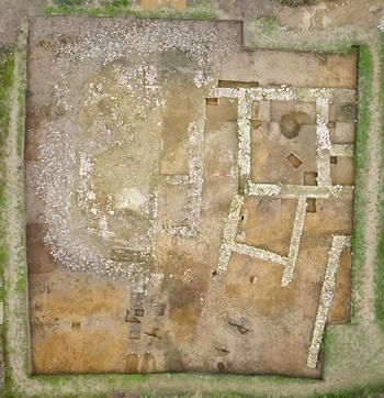
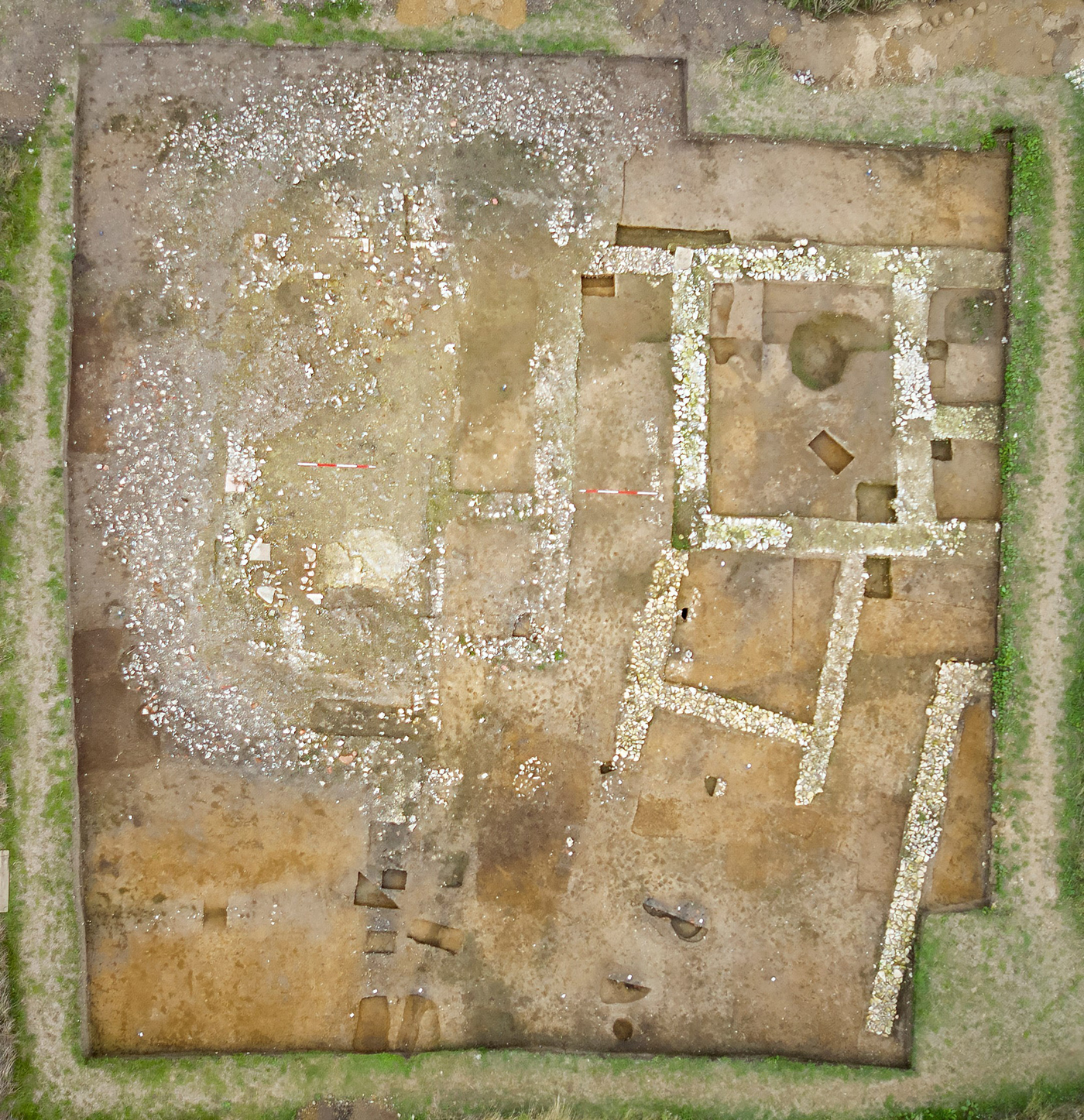
The footprint of the bath-house to the west of the main villa was fully exposed and the surfaces recorded. These remains are now left intact and protected from further plough damage, to be more fully explored in the future. The north–south-orientated bath-suite, which was approximately 10.4 m long and 4.5 m wide internally, may have been multi-phased. It had a probable entrance room at its south-east corner. To the west of this room was the cold room which had a very solid mortared floor and along its west wall a semi-circular apsidal area partly paved with thin slabs of ‘Horsham’ sandstone. These slabs may have formed the base of an apsidal plunge bath, or the support for such. This bath was emptied to the west by means of a ‘U’-shaped lead pipe contained in a tile-lined drain. It appears to have emptied into a lowered area marked at the exposed level by a wide ‘halo’ of flint rubble which surrounds the north, west and southern sides of the baths (fig. 33). This rubble has the appearance of the infilling of a lowered area generally around the baths. North of the cold room (within the baths building) is a large disturbed area, which judging from the geophysical survey results, may be the infilled remains of two deeper rooms; probably one warm, the other hot. The source of such heat was discovered along the northern wall of the baths where there are the remains of a tile flue-arch within the wall and an adjacent external stokehole lined with pieces of Sussex Marble (Paludina limestone). This service area to the north of the baths contains traces of walls which may represent things such as a fuel store. Provisional dating of the tile finds suggests that the baths probably belong to the third or fourth century (similar to the site overall).
Aerial view of the bath-house and the western end of the winged-corridor house at Plumpton villa, 2018. North at top; scales: 2 m. (Photograph: Mark Dobson)
Two trial-trenches started in 2017 across the rubble spread to the east of the winged-corridor house were finished. Of particular interest are two features (one in each trench) cut into the natural below the flint spread. One of these features appears to have been a north–south wall trench. Finds included more carbonised seeds and pottery, including the complete profile of a large jar. Associated coins suggest that Roman occupation of the site commenced during the end of the second century. The areas investigated by excavation between 2014 and 2018 remain out of cultivation.Footnote 103
(2) Ringmer, Bridge Farm, Wellingham (TQ 430 144): three seasons’ work was concluded.Footnote 104 Trench 6 was situated to the north-east of the site over the intersection of the London road and a late second-century double-ditch enclosure. The road overlay the silted ditches with the pottery analysisFootnote 105 suggesting a late third- to early fourth-century date for its reinstatement/use, whilst pottery from the roadside ditches suggested that a road on this route pre-dated the enclosure. A stone-lined well was discovered 2 m below current ground level to the east of the road and just north of the outer enclosure ditch. Pottery from the lower fill of the well indicates deposition occurring post-a.d. 370, suggesting the well was filled during the last years of Roman occupation. The well’s lining was constructed in specific layers with a base of chalk blocks supported by an 800 mm-square box of oak planking. At 1 m from the base the lining changed to two courses of iron-rich sandstone from the High Weald. This corresponds to an iron pan in the fill of the well suggesting persistent ground-water level at this height. The extant lining was topped with irregular lumps of a flint conglomerate but flint nodules found within the well and to the side could suggest a robbed-out upper lining of flint, similar to that found at the nearby Barcombe villa.Footnote 106 Other water-logged planks found loose within the well suggest a collapsed cover or timber inner lining. An oblique cut above the lining may be the construction cut or relate to the demolition of the upper layers. Artefacts recovered included over 27,000 sherds of pottery ranging in date from a.d. 60/70 to 400+ with an emphasis on the late Roman period, reflected in the 168 coins recovered.Footnote 107
(3) Stone Cross, land at Uplands Farm, Rattle Road (TQ 62520 04260): archaeological evaluation identified a dense concentration of archaeological features, comprising pits, ditches and gullies, dating from the late prehistoric to medieval periods, on top of the ridge along the northern border of the site. The late Iron Age/early Romano-British period is represented by ditches, gullies and pits positioned towards the high ground that runs along the north-west boundary of the site, suggestive of settlement activity. A concentration of features within the eastern corner of the site, and possible fragments of fired clay pedestals, indicates salt production or industrial activity. Parallel ditches probably dating to the mid-first century a.d. suggest possible causeways and/or trackways. Within the western area of the site Roman pottery is limited; however, due to their close proximity to extensive Romano-British settlement to the immediate north of the site, these features could be a continuation of this activity.Footnote 108
KENT
(1) Boughton Monchelsea, Lyewood Farm (TQ 77287 51360): evaluation identified a Romano-British ditch with abundant finds, suggestive of a settlement nearby. Evidence for a former ridge and furrow system was also recorded.Footnote 109
(2) Canterbury (Durovernum Cantiacorum), 7–9 St Margaret’s Street (TR 14863 57666): the earliest features revealed during excavationFootnote 110 adjacent to the eastern side of the Roman theatre were pits, post-holes and hearths of late Iron Age or early Roman date. A group of early Roman pits appeared to have been used for the disposal of rubbish and cess. Their large size and soft organic fills caused severe subsidence in an overlying masonry hypocausted building. Elements of the hypocaust survived, including opus signinum floored heating channels, a pilae stack and a stoke-hole. A metalled courtyard, possibly forming part of the environs of the Roman theatre, extended over a large part of the excavation area. A sequence of timber buildings was set west of, and on the same alignment as, the masonry building. The latest of these was a large structure with a metalled courtyard on its northern side. A late linear ditch-like feature in the north-west corner of the site contained human remains. The two earliest burials had been interred with care, but the majority appeared to be dumped, most without skulls.Footnote 111
(3) Faversham, Lady Dane Farm (TR 02596 60873): evaluation identified prehistoric and medieval archaeology alongside Romano-British ditches, indicating agricultural activity at some distance from any settlement. Features securely dating to the mid-first century were comprised exclusively of linear features, and well distributed across the site. A number of the undated features likely belong to this period. The nature of the securely dated features suggests a field-system, possibly related to agricultural activity.Footnote 112
(4) Faversham, Perry Court Farm (TR 01148 60011): an evaluation 200 m to the south of Watling Street uncovered late Iron Age to early Roman settlement features in the form of ditches and a pit. Most of the pottery dates to the mid- to late first century. Locally-made grog-tempered pottery was predominant, but there were also imported wares from north, central and south Gaul and Italy, as well as copies of Gallo-Belgic forms in North Kent fine reduced ware. A three-piece copper-alloy toilet set (tweezers, nail-cleaner and scoop) was also recovered.Footnote 113
(5) Headcorn, Ulcombe Road (TQ 83300 44700): evaluation trenching prior to housing development revealed two small pits, probably the remains of slag-tapping shaft furnaces for smelting iron ore. Two, possibly three, ditches were dated to the late Iron Age or early Roman period and several others (devoid of finds) may have been of similar date and part of the same sub-rectilinear field-system.Footnote 114
(6) Ramsgate, Cliffsend (TR 34238 64497): evaluation trenchingFootnote 115 revealed predominantly late Iron Age to early/mid-Roman linear features, with a few suggesting activity into the third century. A metalled linear feature was probably part of a sequence of hollow ways recorded during the EKA2 excavations.Footnote 116 One ditch appeared to represent the south-west corner of a later Iron Age/early Roman sub-rectangular enclosure set adjacent to the hollow ways. It contained a large concentration of artefacts and environmental indicators of occupation such as marine shell, charcoal and charred plant remains. Part of the large assemblage of pottery, including near-complete vessels, was redolent of purposeful, structured deposition in this corner of the enclosure. Other enclosure ditches contained significant concentrations of early Roman artefacts and/or pottery dating up to the second to third century, whilst other ditches of similar date probably indicate an extensive field-system. A ditch dated to the first century a.d. could represent the south-west corner of another sub-rectangular enclosure. Its southern section was almost parallel to a pair of ditches located just 27 m to the south-west in 2005.Footnote 117
(7) Sittingbourne, land at south-west Sittingbourne (TQ 88395 93735): evaluation identified prehistoric features and Romano-British settlement activity, with evidence of crop processing and limited evidence of industrial activity. Ceramic building material also indicates that there may be a Romano-British building within the southern field with the recovery of part of a hypocaust system.Footnote 118
SUPPLEMENTARY MATERIAL
For Supplementary Material for this article please visit https://doi.org/10.1017/S0068113X19000448