INTRODUCTION
Distributions of plant and animal populations across a landscape change in response to climate at multiple spatial scales (Field et al., Reference Field, Barros, Mach, Mastrandrea, van Aalst, Adger, Arent, Field, Barros, Dokken, Mach, Mastrandrea, Bilir and Chatterjee2014). Global atmospheric patterns and trends are manifested within regions, affecting ecosystem composition and function and, therefore, local resource availability to human populations. Those populations forage within natural vegetation, which determines much about their dietary composition, either directly through plant consumption or indirectly through interactions with animal species sharing the food web. Over long periods of time, environmental change affects the distribution of species and, consequently, the dietary choices of human populations that occupy a particular place (Louderback and Pavlik, Reference Louderback and Pavlik2018). Such dynamics are not well-understood for the Colorado Plateau during the Holocene, where archaeological sites, packrat (Neotoma spp.) middens, and pollen cores are fewer in number and less continuous in their circumscription of plant distributions over the landscape.
The Colorado Plateau includes the southern Four Corners region and encompasses multiple ecosystems, such as montane forests, desert scrub, arid woodlands, and grasslands. It also lies at the crux of major atmospheric circulation, monsoonal, and biogeographic patterns (Betancourt, Reference Betancourt1984; West, Reference West, Barbour and Billings1988; Schwinning et al., Reference Schwinning, Belnap, Bowling and Ehleringer2008). Vegetation change on the Colorado Plateau during the Holocene has been characterized by lowered elevational distributions and a reorganization of communities based on individual responses of plant species (e.g., Betancourt, Reference Betancourt1984). When trying to characterize vegetation change in an entire region (e.g., Colorado Plateau), the story can get complicated, especially when describing individual species’ responses or their arrivals and departures in particular localities. Extrapolating data over smaller spatial scales is more likely to give a clearer picture of past vegetation change and the responses of human foragers to those changes. It is for that reason that this study limits its area of interest to the Colorado Plateau in southern Utah.
Paleo-vegetation records from southern Utah demonstrate that between 11,500 and 10,000 cal yr BP, vegetation communities composed of cool-adapted conifers, such as spruce (Picea), fir (Abies), Douglas fir (Pseudotsuga menziesii), and limber pine (Pinus flexilis) were depressed by at least 700 to 900 m in elevation (Spaulding and Peterson, Reference Spaulding, Petersen and Jennings1980; Betancourt, Reference Betancourt1984; Betancourt et al., Reference Betancourt, Van Devender and Martin1990; Withers and Mead, Reference Withers and Mead1993; Anderson et al., Reference Anderson, Hasbargen, Koehler, Feiler and Anderson1999). By 9700 cal yr BP, Utah juniper (Juniperus osteosperma) was established in elevations as low as 1500 m (Betancourt, Reference Betancourt1984) and by 7200 cal yr BP, it reached 2200 m, where it currently is found. Two-needle pinyon (Pinus edulis) occurs as early as 9000 cal yr BP on Navajo Mountain in northern Arizona (Cole et al., Reference Cole, Fisher, Ironside, Mead and Koehler2013); however, it does not arrive at the Abajo Mountains or at Cowboy Cave in southern Utah until after 5000 cal yr BP (Barnett and Coulam, Reference Barnett, Coulam and Jennings1980; Hewitt, Reference Hewitt and Jennings1980; Betancourt et al., Reference Betancourt, Van Devender and Martin1990; Cole et al., Reference Cole, Fisher, Ironside, Mead and Koehler2013). The retreat of cool-adapted conifers to higher elevations may be a prelude to the appearance of P. edulis–J. osteosperma woodland, along with a high number of culturally significant plant species of great value to foragers on the Colorado Plateau (Adams and Reeder Reference Adams, Reeder and Potter2009; Louderback and Pavlik, Reference Louderback and Pavlik2018).
This study examines pollen, plant macrofossils, and sediments from deposits at North Creek Shelter (NCS), an archaeological site near Escalante, southern Utah. Modern pollen rain collected at, above, and below NCS is used in conjunction with the North American Modern Pollen Database (NAMPD) (Whitmore et al., Reference Whitmore, Gajewski, Sawada, Williams, Shuman, Bartlein and Minckley2005) to supply community analogs for existing vegetation. The resultant data correspond well with other paleoenvironmental records and build a robust regional picture of vegetation change on the Colorado Plateau. We find, for example, that Picea–Abies forests were depressed as much as 950 m in elevation at NCS, suggesting cooler conditions during the early Holocene, accompanied by high sediment accumulation rates that indicate wetter conditions as well. A later shift to warmer and drier conditions is also apparent, forming a semiarid woodland and shrub mosaic (dominated by P. edulis–J. osteosperma and Amaranthaceae) around NCS. This is corroborated by low sediment accumulation rates and erosional processes. We also provide evidence for the migration of P. edulis into southern Utah at approximately 8100 cal yr BP, thus fitting the spatial and temporal expansion as evidenced by the first arrival at Navajo Mountain (Cole et al., Reference Cole, Fisher, Ironside, Mead and Koehler2013).
SITE SETTING
North Creek Shelter
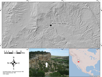
NCS lies at the base (1900 m asl) of a south-facing sandstone cliff (Straight Cliffs Formation) (Morris and Hicks, Reference Morris and Hicks2009) overlooking Escalante Valley in southern Utah (Fig. 1). It is situated in an extensive P. edulis–J. osteosperma woodland near the convergence of the three streams that form the Escalante River, the largest of which is North Creek. The local influence of North Creek and the south-facing cliff introduce other azonal vegetation types (e.g., riparian forest and saltbush scrub). These interwoven communities in and around NCS are referred to as a “cool desert mosaic” (Table 1). At higher elevations (>2500 m asl), ponderosa pine (Pinus ponderosa) and Picea–Abies forests cover large portions of the Dixie National Forest (see Janetski et al., Reference Janetski, Bodily, Newbold and Yoder2012; Louderback, Reference Louderback2014).
(color online) Location of North Creek Shelter in Escalante, southern Utah (inset North America). The site is located at the base of a sandstone cliff, surrounded by P. edulis–J. osteosperma woodland, and adjacent to Fremont cottonwood Populus fremontii–Gambel oak (Quercus gambelii) riparian. Map by Avery Uslaner.

Vegetation types where modern pollen surface samples were collected. Cool desert mosaic surrounds North Creek Shelter today.

Excavations of NCS took place from 2004 to 2008, and recovered collections are accessioned at the Museum of Peoples and Cultures (Brigham Young University) (Janetski et al., Reference Janetski, Bodily, Newbold and Yoder2012). The NCS sequence is more than 4 m deep and highly stratified and contains many archaeological features, such as hearths and pits, as well as abundant stone tools, faunal assemblages, and botanical remains. The finds were recovered from cultural strata deposited between 11,500 cal yr BP and 300 cal yr BP (Fig. 2), and are defined as Paleoarchaic (Strata II, III, and IV; 11,500–10,200 cal yr BP), Early Archaic (Stratum V; 10,200–8000 cal yr BP), Mixed Archaic (Stratum VI; 8000–6700 cal yr BP), Fremont (Stratum VII; 1200–300 cal yr BP), and Late Prehistoric (Stratum VIII) (Fig. 2). The strata were further subdivided into 68 levels or substrata (Va, Vb, Vc, etc.) based on noticeable changes in the sediments, with some substrata interpreted as short-term living/use surfaces associated with Paleoarchaic, Early Archaic, and Fremont occupations.
Stratigraphic profile of North Creek Shelter (adapted from Janetski et al., Reference Janetski, Bodily, Newbold and Yoder2012).

There is a gap in the record from approximately 6700 to 1200 cal yr BP due to heavily bioturbated sediments and, therefore, dating material from these deposits was minimal (Janetski et al., Reference Janetski, Bodily, Newbold and Yoder2012). Stratigraphic analysis of NCS sediments defined a dramatic contrast between the lower (pre-8000 cal yr BP) and upper (post-8000 cal yr BP) deposits (Fig. 2). The lower sediments consist of thin to medium (3- to 30-cm-thick) horizontal strata that alternate between fine- to medium-sized tan sands. The upper deposits are clearly disturbed with darkened sediments and an increase in charcoal and sandstone chunks (Janetski et al., Reference Janetski, Bodily, Newbold and Yoder2012).
Modern vegetation
A total of seven major vegetation types are recognized at, above, and below NCS, occurring between 1400 and 2830 m asl in elevation and over a total distance of 100 km (Table 1). Five of these occur within a radius of 19 km of NCS, and NCS itself is surrounded by a mosaic of P. edulis–J. osteosperma woodland, riparian forest, and cool desert scrub, depending upon topographic position (Louderback and Pavlik, Reference Louderback and Pavlik2018).
Forest types in the Escalante region include mature stands of Picea–Abies, P. ponderosa, and cottonwood–willow riparian (Populus–Salix). These forests range in elevation from 1900 to 2830 m asl. The riparian forest is adjacent to NCS, while P. ponderosa and Picea–Abies forests are found 17 to 19 km to the northwest of the rockshelter, respectively. Woodland vegetation includes mature stands of P. edulis–J. osteosperma (2200 m asl) and J. osteosperma savannah (1650 m asl). NCS is located near stands of P. edulis–J. osteosperma, but several kilometers from the J. osteosperma savannah.
Scrub vegetation includes cool and warm desert scrub, separated by 500 m of elevation and more than 64 km of gradual decline in the landscape toward the southwest. The cool desert scrub occurs at 1890 m asl in elevation and is dominated by sagebrush (Artemisia tridentata) and four-wing saltbush (Atriplex canescens). Along with P. edulis–J. osteosperma woodland and riparian forest, it forms a mosaic in the immediate vicinity of NCS. The warm desert scrub (1410 m asl) consists primarily of blackbrush (Coleogyne ramosissima), jointfir (Ephedra torreyana), and galleta grass (Pleuraphis jamesii).
METHODS
Chronology
The chronology of deposits at NCS is derived from 36 (n = 36) accelerator mass spectrometry (AMS) 14C ages, 20 of which are published in Janetski et al. (Reference Janetski, Bodily, Newbold and Yoder2012) with an additional 16 obtained thereafter. Deriving a reasonable age model for these deposits required selecting a subset of ages (n = 20) (Fig. 3; Table 2). Ages were chosen from: (1) in situ cultural features (i.e., hearths), (2) the youngest occupation layers (terminus post quem), and (3) plant or bone specimens that were taxonomically identified (e.g., P. edulis needle leaves, maize (Zea mays) kernels, deer (Odocoileus hemionus) collagen) rather than pooled material when possible. Finally, we excluded obvious outliers that defied sets of accepted dates. Thus, many of the reversals are excluded from the attenuated chronology. Treating the ages in this manner establishes a narrower and more reasonable range of plausible ages for the paleo-vegetation data presented in this study. These age ranges are consistent with Bayesian models of the 14C ages while making fewer assumptions about the constant sedimentation rates and the complex nature of interbedded cultural and noncultural strata that characterize NCS. Calibrated age ranges are calculated with OxCal (Bronk-Ramsey and Lee, Reference Bronk-Ramsey and Lee2013) and plotted using the R statistical computing environment (v. 3.2.1; R Core Team, 2015). R code is available upon request.
(color online) Schematic diagram showing North Creek Shelter (NCS) radiocarbon age probability distributions by substratum. Calibrated ages used to infer the chronology of paleo-vegetation change at NCS are plotted as filled curves connected by a dotted line. Hatched curves are outlying or old wood ages (not used in this study). Probability distributions were calibrated and imported from OxCal (Bronk-Ramsey and Lee, Reference Bronk-Ramsey and Lee2013).

Radiocarbon ages from North Creek Shelter.

Sedimentology
NCS sediments were examined in August of 2008 when excavations had achieved near-maximum depth and site stratigraphy was clearly exposed. Seven sediment samples were collected along the vertical column and processed through six USA Standard Testing Sieves (nos. 10 [2 mm], 18 [1 mm], 35 [500 µm], 60 [250 µm], 120 [125 µm], and 230 [63 µm]). Samples were run on a Ro-Tap® for 3.5 min, fractionated, and then weighed to obtain grain size distribution along the profile (Morris and Hicks, Reference Morris and Hicks2009). Results were compared with grain-size distributions and statistical calculations from other depositional systems to interpret sedimentological history (e.g., Blair and McPherson, Reference Blair and McPherson1992). Sedimentation rates (cm/yr) from the lower (Strata I–V) and upper (Strata VI–VIII) strata were calculated by dividing the depth of the deposits by the number of accumulation years.
Fossil pollen
Sixty-seven (n = 67) sediment samples were collected in 5 cm intervals from the entire profile of the east and west walls at NCS. To ensure adequate amounts of pollen were available for analysis, 7 mL of sediment was processed for pollen. Extraction from the sediment was accomplished using standard procedures, including successive HCl, HF, KOH, and acetolysis treatments (Faegri and Iversen, Reference Faegri and Iversen1989; also see Louderback and Rhode, Reference Louderback and Rhode2009), as well as lithium heteropolytungstate heavy-liquid separation (Munsterman and Kerstholt, Reference Munsterman and Kerstholt1996; Lentfer and Boyd, Reference Lentfer and Boyd2000). Of the 67 sediment samples processed, only 23 yielded identifiable pollen. The remaining 44 samples did not contain pollen grains or produced too few to interpret paleo-vegetation change.
Pollen extracts were mounted with glycerol on glass slides and were examined through a light microscope at 400× magnification. A minimum of 400 pollen grains were counted in each sample, except for those with poor pollen preservation (n = 8; see Supplementary Table 1), in which case a sum of 70–150 grains were counted. Pollen was identified to the lowest possible taxonomic level using modern reference material and published pollen keys (Moore and Webb, Reference Moore and Webb1978; Kapp et al., Reference Kapp, Davis and King2000). Most pollen grains were identified to genus, but for some types identification was only possible to family. Pinus pollen grains are typically identified as one of three different categories: diploxylon (e.g., P. ponderosa), haploxylon (e.g., P. flexilis, pinyon–type), and undifferentiated Pinus. The poor preservation of archaeological pollen from NCS prevents such precise identifications. Therefore, pollen diagrams presented here only use one category (Pinus) to track Pinus pollen. Unidentifiable pollen grains fall into two categories, unknown and indeterminate; unknown grains are intact but could not be assigned to a taxon, whereas indeterminate grains are either damaged beyond recognition or obscured behind other material within the slide matrix.
Pollen percentages are calculated based on the sum of total pollen (excluding indeterminate grains) and are plotted as relative abundances using the stratigraphic plotting package Rioja (Juggins, Reference Juggins2015) within the R statistical computing environment (v. 3.2.1; R Core Team, 2015). The raw counts for the pollen data set are provided in Supplementary Table 1 and are archived in the Neotoma Paleoecology Database (http://www.neotomadb.org).
Pollen ratios that compared specific taxa (e.g., Amaranthaceae and all conifers) are used to differentiate between warm and cool environmental conditions (Madsen and Currey, Reference Madsen and Currey1979; Mehringer, Reference Mehringer, Bryant and Holloway1985). The ratios are calculated as RCA = (C − A)/(C + A), where RCA = the ratio between Conifers to Amaranthaceae, C = absolute abundance of conifer pollen, and A = absolute abundance of Amaranthaceae pollen. The ratio is measured in standard units from + 1 to −1. A value of zero denotes an equal percentage of grains from each pollen type. Values of + 1 or −1 reflect the complete absence of one type or the other, respectively. These results are plotted using the R statistical computing environment (v. 3.2.1; R Core Team, 2015).
Plant macrofossils
Plant macrofossil samples were sorted from 192 hearth features that were excavated from 37 substrata at NCS. The nondietary plant macrofossil remains mostly include burnt conifer leaf or needle fragments (for dietary macrofossils, see Louderback [2014]). The morphology and vascular structure of conifer needles allow differentiation of taxa to species level (e.g., Betancourt, Reference Betancourt1984; Coats et al., Reference Coats, Cole and Mead2008; Cole et al., Reference Cole, Fisher, Arundel, Cannella and Swift2008). Therefore, plant macrofossils often corroborate identifications based on pollen, typically to family or genus, but possibly to species as well. Reconciliation between pollen and macrofossil data sets, however, is not always straightforward. For example, some plant taxa (e.g., Pinaceae) produce copious pollen along with hardy needle leaves that preserve in archaeological sites. Others, such as oak (Quercus), produce lesser amounts of pollen, and their deciduous leaves do not preserve very well. Changes in the local environment between strata were quantitatively measured by calculating relative abundances of these taxonomically assigned, noncultural plant materials. The raw counts for the macrofossil data set are provided in the Supplementary Table 2 and are archived in the Neotoma Paleoecology Database (http://www.neotomadb.org).
Plant macrofossil data are expressed as relative abundances and plotted using the Rioja package (Juggins, Reference Juggins2015) within the R statistical computing environment (v. 3.2.1; R Core Team, 2015). A ratio that compares specific taxa (e.g., cool-adapted conifers with P. edulis–J. osteosperma) is used to differentiate between warm and cool environmental conditions. The ratio is calculated as RCP = (C − P)/(C + P), where RCP = the ratio between cool-adapted conifers species to P. edulis–J. osteosperma species, C = absolute abundance of conifer species (Abies concolor [white fir], P. menziesii, P. ponderosa, and Juniperus scopulorum [Rocky Mountain juniper]), and P = absolute abundance of P. edulis–J. osteosperma species. The ratio is measured in standard units from + 1 to −1. A value of zero denotes an equal percentage of grains from each pollen type. Values of + 1 or −1 reflect the complete absence of one type or the other, respectively.
Comparison of fossil and modern pollen
Dissimilarities between modern and fossil pollen assemblages at NCS are examined to establish the nature of Holocene vegetation change at NCS, especially as it relates to the changing elevations of cool conifer forests and warm conifer forests. Modern pollen samples were collected from surface sediments in 50 mL vials from the seven vegetation types described earlier (Table 1). These samples were processed and analyzed for pollen using the same procedures discussed earlier, including heavy-liquid separation. Together with 86 modern pollen samples from the NAMPD (Whitmore et al., Reference Whitmore, Gajewski, Sawada, Williams, Shuman, Bartlein and Minckley2005) drawn from coordinates covering the Colorado Plateau (36–40°N, 108–112°W), these samples are used to establish how archaeological samples represent plant communities on the landscape.
Modern pollen samples are compared with fossil pollen abundances from NCS sediments using the squared-chord distance metric, which measures the dissimilarity between fossil and modern pollen assemblages (Jackson and Williams, Reference Jackson and Williams2004). Squared-chord distances were calculated and plotted using the R statistical computing package (v. 3.2.1; R Core Team, 2015). Results are standardized per stratum using z-scores based on the difference from the mean squared-chord distance in standard deviation units, excluding samples with values greater (i.e., grossly dissimilar) than the mean. This is done to make obvious which modern samples are the most similar to each archaeological sample. The NCS modern pollen data are provided in Supplementary Table 3 and are archived in the Neotoma Paleoecology Database (http://www.neotomadb.org). (R code and NAMPD data set used to create plots are available upon request.)
RESULTS
We describe vegetation changes at NCS by analyzing the relative abundances of pollen and plant macrofossils in stratigraphic context combined with our own chronological framework (Fig. 3).
Vegetation changes by stratigraphic level
Strata I and II (11,300 cal yr BP)
The earliest deposits from NCS (Stratum I, ~4.4 m below the datum) are culturally sterile (Janetski et al., Reference Janetski, Bodily, Newbold and Yoder2012), and the first evidence of human occupation at NCS appears in Stratum II. The chronology of these deposits is controlled by five 14C samples from charcoal (n = 2) and bone (n = 3) and indicate that the deposits accumulated rapidly beginning at about 11,300 yr BP. Sedimentological analyses suggest that NCS sediments are poorly sorted; that is, they contain a broad range of grain sizes (1–4 phi) and larger grain sizes than observed in eolian-deposited sediments. These patterns result in a unimodal frequency distribution curve of grain sizes and are typical of sediments deposited by water (Morris and Hicks, Reference Morris and Hicks2009; Supplementary Fig. 1). Eolian sediments are usually well sorted (smaller range of grain sizes) and have a frequency distribution that is bimodal (Blair and McPherson, Reference Blair and McPherson1992).
Paleo-vegetation data come from eight pollen samples associated with Substrata Ie, Ig, Ii, IIb, IIc, IId, IIe, and IIf. At around 11,300 cal yr BP, the environment around NCS was dominated by a Pseudotsuga ( $\bar{x}$ = 31% of all grains) and Pinus (
 $\bar{x}$ = 28%) forest with Artemisia (
 $\bar{x}$ = 13%) in the understory. Lower abundances of Amaranthaceae (“cheno-ams”;
 $\; \bar{x}$ = 6%), Asteraceae (
 $\bar{x}$ = 9%), and Quercus (
 $\bar{x}$ = 7%) also occur (Fig. 4). Pinus pollen most likely reflects P. ponderosa, which presently grows approximately 600 m above NCS.
Relative abundances of pollen taxa from North Creek Shelter sediments, plotted by substratum (left y-axis) and age (cal yr BP) (right y-axis). Bar colors reflect plant communities (left to right): black, cool-adapted conifers; dark gray, warm-adapted conifers; light gray, arid shrubs and herbs.

Plant macrofossils were recovered from seven substrata (Ie, IIa, IIb, IIc, IId, IIe, and IIg) and are dominated by P. ponderosa ( $\bar{x}$ = 55% of all leaves), Abies (
 $\bar{x}$ = 23%), and lesser amounts of Juniperus (
 $\bar{x}$ = 12%) and J. scopulorum (
 $\bar{x}$ = 9%) (Fig. 5).
Relative abundances of plant macrofossils identified from North Creek Shelter deposits, plotted by substratum (left y-axis) and age (cal yr BP) (right y-axis). Bar colors reflect plant communities (left to right): black, cool-adapted conifers; gray, warm-adapted conifers.

Strata III and IV (11,200–10,200 cal yr BP)
Several deposits in these levels (~4.0–3.0 m) are characterized by layers of fire-reddened sandstone slabs as well as reddened sediments and burnt plant macrofossils beneath the slabs. Reddened or oxidized sediments always lay immediately below a stratum containing evidence of more intensive human use in the form charcoal-darkened deposits, usually with an increase in artifact yield. These reddened sediments were in stark contrast to tan sands that made up the bulk of these lower levels. Janetski et al. (Reference Janetski, Bodily, Newbold and Yoder2012) surmise that the occupants of NCS during this time laid down a mat of conifer twigs (probably collected from the vicinity of NCS), overlaid it with sandstone slabs, and fired the vegetal layer for some unknown purpose. The first appearance of a few small, thin fragments of ground stone tools in Stratum IV (Janetski et al., Reference Janetski, Bodily, Newbold and Yoder2012) is also notable. The chronology of these deposits was derived from five 14C samples of charcoal (n = 1), bone (n = 3), and dentin (n = 1) that date Strata III and IV from approximately 11,200–10,200 cal yr BP (Fig. 3). As in Strata I and II, sediments from Strata III and IV were deposited rapidly, probably transported by heavy precipitation or snowmelt down vertical cracks in the cliff face (Morris and Hicks, Reference Morris and Hicks2009; Janetski et al., Reference Janetski, Bodily, Newbold and Yoder2012). Evidence for rapid deposition consists of comparing sediment accumulation over the millennia. The lower layers (Strata I–V, ~3 m) were deposited over about 3500 years, while the upper layers (Strata VI–VIII, ~1.4 m) accumulated over nearly 8000 years. Based on these data, Morris and Hicks (Reference Morris and Hicks2009) calculated a deposition rate of 0.09 cm/yr, while the upper levels’ deposition rate is 0.018 cm/yr, almost five times slower. In addition, Strata I–V are horizontally bedded with little rubble and that which is present is horizontal or parallel to strata (Fig. 2).
Eight pollen samples come from these deposits and are associated with Substrata IIIa, IIId, IIIf, IVa, IVd, IVf, IVh, and IVr. These samples indicate that during the time when Substrata IIIa and IIId were deposited, NCS was surrounded by Pseudotsuga ( $\bar{x}$ = 49%), Pinus (
 $\bar{x}$ = 24%), and Artemisia (
 $\bar{x}$ = 11%). Pollen from IIIf, however, indicates a change in dominant vegetation represented by Pseudotsuga (34%), Quercus (23%), and Amaranthaceae (21%) (Fig. 4). Pollen preservation in Stratum IV is poor, but a decrease in Pinus (
 $\bar{x}$ = 5%) and an increase in Pseudotsuga pollen (
 $\bar{x}$ = 37%) suggest Pinus (likely P. ponderosa) was retreating upslope from NCS. Quercus (
 $\bar{x}$ = 11%), Artemisia (
 $\bar{x}$ = 12%), and Amaranthaceae (
 $\bar{x}$ = 7%) occur in lower abundances. In Substratum IVr, Pinus (69%) returns, while Pseudotsuga (14%) decreases (Fig. 4).
Plant macrofossils were identified from Substrata IIIb, IIIc, IIIe, IIIg, IVa, IVb, IVc, IVe, IVf, IVg, IVh, IVj, IVk, IVm, and IVo. Each substratum in Stratum III contained needle leaves dominated by a different set of conifer species: Substratum IIIb was dominated by P. ponderosa (88%) and Juniperus (12%); IIIc was dominated by P. menziesii (76%), P. ponderosa (18%), and Juniperus (6%); IIIe contained Abies (77%), P. ponderosa (16%), and J. scopulorum (5%); and finally, IIIg was dominated completely by P. ponderosa (100%). This continued for Stratum IV; P. ponderosa needle fragments ( $\bar{x}$ = 87%) dominated the record, with lower amounts of Juniperus (
 $\bar{x}$ = 7%) and P. menziesii (3%) (Fig. 5).
Stratum V (10,200–8000 cal yr BP)
The deposits in these strata (3.0–2.0 m) mark the transition from Paleoarchaic to Early Archaic, with a significant increase in ground stone tools and the first appearance of notched points. Other features, such as a superstructure and large roasting pits (both from Substratum Vt), are also unique to these levels (Janetski et al., Reference Janetski, Bodily, Newbold and Yoder2012). The chronology comes from four 14C samples indicating that Stratum V was deposited between approximately 10,200–8000 cal yr BP (Fig. 3).
Pollen data come from Substrata Va, Vf, Vi, Vq, Vs, VIa, and VId and show multiple changes in vegetation. Pollen is poorly preserved in Substrata Va, Vf, and Vi and percentages are based on at most 140 grains. Early in Substratum Va (10,200 cal yr BP), Pseudotsuga (70%) and Pinus (18%) dominate the NCS record. After that, in Vf, Quercus (68%) dominates the pollen record, and by Substratum Vi (~9300 cal yr BP), the pollen record is evenly shared by Pinus (28%), Quercus (24%), Amaranthaceae (18%), Pseudotsuga (13%), and birch/alder (Betula/Alnus) (12%). In Substrata Vq and Vs (9300–8000 cal yr BP), there is a change in dominant vegetation at NCS, where Pinus ( $\bar{x}$ = 33%) and Amaranthaceae (
 $\bar{x}$ = 26%) occur in high abundances, and Juniperus (
 $\bar{x}$ = 9%), Artemisia (
 $\bar{x}$ = 7%), and Pseudotsuga (
 $\bar{x}$ = 6%) occur in low abundances. The Pinus pollen most likely represents P. edulis and the Juniperus is probably J. osteosperma (Fig. 4). Changes in paleo-vegetation are perhaps more apparent in the ratio between conifer and Amaranthaceae pollen (Fig. 6). The steady decline in conifer pollen begins in Stratum V and continues until the end of the early Holocene.
(color online) Line graphs showing ratios of major plant communities represented in the pollen (left) and plant macrofossil samples (right) from North Creek Shelter. Ratios are calculated as the difference between the two groups divided by their sum.

Plant macrofossils come from a total of 16 substrata and reflect the aforementioned patterns. The first vegetation change emerges from samples associated with Substrata Va, Vb, Vc, Ve, Vh, and Vi (10,200–9300 cal yr BP). In these deposits, scale leaves and twigs from J. osteosperma ( $\bar{x}$ = 54%) and needle leaves from P. ponderosa (
 $\bar{x}$ = 29%) dominate the record. Substratum Ve shows a spike in J. scopulorum scale leaves, but there were few other macrofossils recovered from that deposit. Another vegetation change is seen in plant macrofossil samples associated with Substrata Vj, Vm, Vn, Vp, Vr, Vs, Vt, and Vu (9300–8000 cal yr BP). In these deposits, the record is dominated by J. osteosperma (
 $\bar{x}$ = 55%) and P. edulis (
 $\bar{x}$ = 31%), indicating the establishment of a P. edulis–J. osteosperma woodland around NCS. Small amounts of P. ponderosa needles (
 $\bar{x}$ = 10%) and unidentified Juniperus scale leaves (
 $\bar{x}$ = 4%) are also found (Fig. 5). The timing for the arrival of P. edulis into southern Utah was also determined by directly dating a needle fragment from Substratum Vm to 8100 cal yr BP (7310 ± 40 14C yr BP, Beta_369574) (Fig. 7).
Pinus edulis needle leaf fragment dated to 8100 cal yr BP. Ep, epidermis; RD, resin duct; M, mesophyll; TC, transfusion cells; En, endodermis; VB, vascular bundle. SEM image courtesy of D. Rhode (Desert Research Institute, University of Nevada, Reno), labels added by LAL.

Patterns of paleo-vegetation change are more clearly depicted when the abundances of cool-adapted conifer leaves (i.e., Abies, P. menziesii, P. ponderosa, and J. scopulorum) are compared with the abundances of P. edulis and J. osteosperma leaves. This ratio reveals a change to P. edulis–J. osteosperma woodland beginning in Substratum Va and then fully established in Vj (Fig. 6).
Stratum VI (8000–6700 cal yr BP)
Deposits in Stratum VI (2.0–1.8 m) consist of loose, charcoal-stained sands and rubble that were deposited slowly over nearly 1500 yr. Upper disturbed deposits, including Stratum VI, contained horizontally bedded blocks of lighter-colored sediments that were laterally terminated by rodent intrusions and human activity in the form of pits. Additionally, this stratum contained a higher quantity of randomly oriented sandstone chunks derived from the local Straight Cliffs Formation (Morris and Hicks, Reference Morris and Hicks2009). Although massive bioturbation and substantial human activity characterize Stratum VI as “Mixed Archaic,” two intact strata blocks (VIa and VId) were noted. Radiocarbon samples obtained from those levels range in age from 8000 to 6700 cal yr BP (Janetski et al., Reference Janetski, Bodily, Newbold and Yoder2012), and these ages (Table 2), along with the presence of several Rocker side-notched points from Stratum VI, suggest use during the early to middle Archaic (Holmer, Reference Holmer and Jennings1980). Two dates on Z. mays kernels recovered from Stratum VI both fall within the Formative or Fremont era, well after the middle Archaic period (Table 2). This temporal reversal is best explained as vertical displacement of the kernels by the bioturbation mentioned earlier.
Pollen samples from Substrata VIa and VId reveal a shift to more arid conditions where Amaranthaceae ( $\bar{x}$ = 52%) dominates for the first time (Fig. 6) and Pinus (
 $\bar{x}$ = 28%) and Juniperus (
 $\bar{x}$ = 6%) occur in lower abundances (Fig. 4). Plant macrofossils from Substrata VIa and VId show the continued presence of a P. edulis–J. osteosperma woodland surrounding NCS with P. edulis (
 $\bar{x}$ = 66%) needle leaves and J. osteosperma (
 $\bar{x}$ = 20%) scale leaves dominating the record (Fig. 5).
Strata VII and VIII (1200–300 cal yr BP)
There is a gap in the NCS record from approximately 6700 to 1200 cal yr BP. Based on five 14C samples from Z. mays (n = 3), collagen (n = 1), and dentin (n = 1), Strata VII and VIII date from approximately 1200 to 300 cal yr BP. The depth of these deposits is approximately 2.0–1.2 m, and they are characterized as “Fremont/Late Prehistoric” (Janetski et al., Reference Janetski, Bodily, Newbold and Yoder2012).
The patterns of paleo-vegetation change observed in Stratum VI are also seen in Strata VII and VIII. Pollen samples from Substrata VIIa, VIIc, and VIIIc show Amaranthaceae dominating ( $\bar{x}$ = 44%), followed by Pinus (
 $\bar{x}$ = 27%), Juniperus (
 $\bar{x}$ = 7%), and Artemisia (
 $\bar{x}$ = 5%) (Fig. 4). Plant macrofossil samples from Substrata VIIb and VIIc show a mixture of J. osteosperma (
 $\bar{x}$ = 49%). P. edulis (
 $\bar{x}$ = 23%), P. menziesii (
 $\bar{x}$ = 17%), and P. ponderosa (
 $\bar{x}$ =11%) (Fig. 5).
Comparing fossil and modern pollen assemblages
The lower the squared-chord distance value, the more similar fossil pollen is to modern pollen rain and, conversely, the higher the value, the more dissimilar. In Strata I–IIId, (approximately 11,300 and 10,600 cal yr BP), fossil pollen from NCS is most similar to modern pollen from the Picea–Abies forests above NCS (Fig. 8). Within Strata IIIf, IV, and Va (about 10,600 to 9300 cal yr BP), there is an apparent vegetation change, with some of the fossil pollen samples (IIIf, IVa, IVf, IVr, and Va) becoming more similar to modern pollen from Picea–Abies and P. ponderosa forests, while others (IVd and IVh) are more similar to cool desert mosaic. After that, in Strata Vf, VI, VII, and VIII (9300–6700 cal yr BP; 1200–300 cal yr BP), fossil pollen from NCS is consistently most similar to modern pollen from the cool desert mosaic, including P. edulis–J. osteosperma woodlands and Amaranthaceae scrub (Fig. 8).
Comparison of fossil and modern pollen assemblages, the former collected at North Creek Shelter and the latter along elevational gradients on the Colorado Plateau. The size and color of the circles represent how similar the fossil pollen sample is to the modern sample from a given elevation, expressed as standardized z-scores for each stratum. The larger the circle and the lighter the color, the greater the similarity between modern and fossil pollen assemblages (calculated as number of standard deviations below the mean squared-chord distance for each sample). For clarity, squared-chord distance values above the mean (i.e., grossly dissimilar) have been excluded.

DISCUSSION
Elevational depression of cool-adapted conifers (11,300–10,200 cal yr BP)
Paleo-vegetation records from the Colorado Plateau in southern Utah demonstrate that during the early Holocene, vegetation communities composed of cool-adapted conifers such as Picea, Abies, Pseudotsuga, and Pinus flexilis were depressed by as much as 900 m in elevation (Spaulding and Peterson, Reference Spaulding, Petersen and Jennings1980; Betancourt, Reference Betancourt1984; Betancourt et al. Reference Betancourt, Van Devender and Martin1990; Withers and Mead, Reference Withers and Mead1993; Anderson et al., Reference Anderson, Hasbargen, Koehler, Feiler and Anderson1999, Reference Anderson, Betancourt, Mead, Hevly and Adam2000). At NCS, we see a similar scenario, where Abies, Pseudotsuga, and P. ponderosa surrounded NCS from 11,300–10,200 cal yr BP, an elevational depression of ~950 m for Abies and Pseudotsuga and ~600 m for P. ponderosa. This is corroborated by comparisons of fossil and modern pollen assemblages that demonstrate fossil pollen from 11,300 to 10,200 cal yr BP for the most part is similar to modern pollen from P. ponderosa and Picea–Abies forests. Pinus ponderosa first appears at NCS as early as 11,300 cal yr BP as needles in Substratum IIa, with increasing abundance until approximately 10,200 cal yr BP. This is similar in what Anderson et al. (Reference Anderson, Hasbargen, Koehler, Feiler and Anderson1999) found on the Markagunt Plateau, where P. ponderosa pollen influx substantially increases around 10,700 cal yr BP. The establishment of cool-adapted conifer forests near NCS and the rapid deposition rate of NCS sediments strongly suggest climatic conditions between 11,300 and 10,200 cal yr BP were cooler than modern, with increased precipitation. This cooler and wetter regime is consistent with other paleoenvironmental records in southern Utah that are correlated with the strengthening of intense summer monsoons from 11,500 cal yr BP until approximately 9500 cal yr BP (Spaulding and Peterson, Reference Spaulding, Petersen and Jennings1980; Betancourt et al., Reference Betancourt, Van Devender and Martin1990; Anderson et al., Reference Anderson, Hasbargen, Koehler, Feiler and Anderson1999; Reheis et al., Reference Reheis, Reynolds, Goldstein, Roberts, Yount, Axford, Cummings and Shearin2005; Morris et al., Reference Morris, DeRose and Brunelle2015).
Transition to warmer and drier conditions (10,200–9300 cal yr BP)
The onset of warming conditions at NCS begins around 10,200 cal yr BP, marked by the steady decline of conifer pollen relative to Amaranthaceae pollen (Fig. 5). High abundances of Quercus pollen at around 9300 cal yr BP are also an indication of warmer conditions at NCS and have been detected in other early Holocene records from southern Utah (Spaulding and Van Devender, Reference Spaulding, Van Devender and Jennings1980; Withers and Mead, Reference Withers and Mead1993). Likewise, the alternating abundances of cool- and warm-adapted conifer needle fragments at NCS from 10,200 to 9300 cal yr BP also characterize this transitional period, as do variations in similarity to Picea–Abies forests or cool desert mosaic between fossil and modern pollen assemblages (Fig. 6). After approximately 9300 cal yr BP, there was a gradual buildup of site deposits, consistent with a significant drop in precipitation. The implications for climate change are clear from these data as well as from the absence of bioturbation and the diminished charcoal staining in the lower strata.
This transition to warmer conditions beginning around 9500 cal yr BP is suggested in other studies from southern Utah. Betancourt (Reference Betancourt1984, p. 25) notes a “major turnover” in flora between 11,000 and 10,000 cal yr BP, where many high-elevation conifers drop out of the midden records from Allen Canyon and Fishmouth Caves in southeastern Utah. On the Markagunt Plateau, Abies and Picea moved upslope, while P. ponderosa expanded downslope (Anderson et al., Reference Anderson, Hasbargen, Koehler, Feiler and Anderson1999), and in Canyonlands, the accumulation of sheetwash deposits and an increase in xeric vegetation suggest arid conditions (Reheis et al., Reference Reheis, Reynolds, Goldstein, Roberts, Yount, Axford, Cummings and Shearin2005).
Increased aridity and Pinus edulis arrival (9300–6700 cal yr BP)
Increasing aridity after 9300 cal yr BP is indicated by a shift from a mixed conifer forest of cool-adapted species (Abies, P. menziesii, and P. ponderosa) to a semiarid woodland and shrub mosaic (dominated by P. edulis, J. osteosperma, and Amaranthaceae) (Figs. 4–6). It is also after 9300 cal yr BP that fossil pollen is consistently most similar to surface samples from cool desert mosaic plant communities (Fig. 8). The establishment of a P. edulis–J. osteosperma woodland around NCS at approximately 9300 cal yr BP is indicated by the abundance of P. edulis needle fragments and J. osteosperma scale leaves.
Many paleoenvironmental records from southern Utah indicate that warming and drying conditions beginning around 9500 cal yr BP continued through the middle Holocene until around 7000 cal yr BP (Betancourt, Reference Betancourt1984; Withers and Mead, Reference Withers and Mead1993; Anderson et al., Reference Anderson, Hasbargen, Koehler, Feiler and Anderson1999; Reheis et al., Reference Reheis, Reynolds, Goldstein, Roberts, Yount, Axford, Cummings and Shearin2005; D'Andrea, Reference D'Andrea2015). In the case of the Aquarius Plateau, however, pollen records indicate cooler and wetter conditions from 8600 to 6000 cal yr BP (Morris et al., Reference Morris, DeRose and Brunelle2013). Discrepancies like this could be due to the complexities in vegetation zones and differences in landscape position between sites that could result in very different vegetation histories (e.g., Coats et al., Reference Coats, Cole and Mead2008; Louderback et al., Reference Louderback, Rhode, Madsen and Metcalf2015).
The timing of the migration of P. edulis into southeastern Utah has been suggested to occur after 5800 cal yr BP (Coats et al., Reference Coats, Cole and Mead2008), despite its arrival in northern Arizona (Navajo Mountain) at 8900 cal yr BP (Cole et al., Reference Cole, Fisher, Ironside, Mead and Koehler2013). This study adds another data point to the migration story with a directly dated P. edulis needle fragment from NCS at 8100 cal yr BP (Fig. 7), thus fitting the northward expansion pattern discussed in Cole et al. (Reference Cole, Fisher, Ironside, Mead and Koehler2013) and Coats et al. (Reference Coats, Cole and Mead2008).
Modernization of local vegetation (1200–300 cal yr BP)
Gaps in the NCS pollen and plant macrofossil records between 6700 and 1200 cal yr BP truncate the analysis of Holocene climate and vegetation changes. However, the community dominants found there today appear to be the same as those in the Middle Holocene, including xeric shrubs of Amaranthaceae as well as the dwarf trees P. edulis and J. osteosperma. Modernization of the local flora in southeastern Utah is likely to have occurred around this period (Betancourt Reference Betancourt1984, p. 25) with the arrival of P. edulis, pricklypear (Opuntia polyacantha), narrowleaf yucca (Yucca angustissima), cliffrose (Purshia mexicana), buffaloberry (Shepherdia rotundifolia), bitterbrush (Purshia tridentata), and Indian ricegrass (Acnatherum hymenoides). This pattern is also seen in the Salt Creek and White Rim (southern Utah) midden sequences, where modern plant species are seen for the first time, including A. canescens, snakeweed (Gutierrezia sarothrae), C. ramosissima, and P. edulis (Coats et al., Reference Coats, Cole and Mead2008). Betancourt (Reference Betancourt1984, p. 25) suggests that the appearance of these new species could be the result of a middle Holocene expansion of xeric woodland communities in southern Utah.
CONCLUSIONS
The NCS sediment, pollen, and plant macrofossils provide a multiproxy and fine-grained record of climate and vegetation change during the Holocene on the Colorado Plateau in southern Utah (Table 3). From approximately 11,300–10,200 cal yr BP, Picea–Abies forests were depressed as much as 950 m in elevation at NCS, suggesting cooler conditions during the Early Holocene. This is accompanied by high sediment accumulation rates at NCS that indicate wetter conditions as well. The onset of warmer conditions at NCS began at 10,200 cal yr BP, and pollen and plant macrofossils indicate that a semiarid woodland and scrub mosaic dominated by P. edulis, J. osteosperma, and Amaranthaceae surrounded NCS by 9300 cal yr BP. This is corroborated by fossil pollen that is similar to modern pollen from P. edulis–J. osteosperma woodlands and Amaranthaceae scrub that currently surround NCS. Sedimentary analyses suggest that during this time, accumulation rates were very low due to low precipitation and a drier climate overall. Migration of P. edulis into southern Utah is directly dated to 8100 cal yr BP, thus following the previously suggested pattern of northward expansion.
Summary of results from the North Creek Shelter sediment, pollen, and plant macrofossil records.

These changes in climate and vegetation at NCS offer a possible explanation for the human dietary patterns and technological shifts (e.g., increase use in small seeds and ground stone technology) detected at many archaeological sites across the West (Grayson Reference Grayson2011) and indeed across the globe (e.g., Wright, Reference Wright1994; Edwards and O'Connell, Reference Edwards and O'Connell1995; Liu et al., Reference Liu, Field, Fullagar, Zhao, Chen and Yu2010). Our findings show that the occupants at NCS had available to them a different set of essential plant resources at different times throughout the Holocene.
ACKNOWLEDGMENTS
Financial support for this research was provided by National Science Foundation, award no. BCS-0818971 and a National Science Foundation Doctoral Dissertation Improvement Grant, award no. BCS-1262835. Additional funding came from University of Washington (Anthropology Department), Brigham Young University (Anthropology Department, College of Home and Family Sciences, and the Charles Redd Center for Western Studies), and University of Nevada, Las Vegas (Graduate and Professional Student Association). Thank you to David Rhode for providing data on the radiocarbon date for the P. edulis needle. We also appreciate the help of Don Grayson and Bruce Pavlik, who edited different versions of the paper, and the University of Utah Archaeological Center Lab group, whose suggestions improved this paper. We are grateful to the Quaternary Research reviewers: Larry Coats, William Johnson, and James Shulmeister—their comments and recommendations were very helpful. We would also like to thank Joette-Marie Rex and her family for giving us access to their property (North Creek Shelter). Their generosity and hospitality made it possible for us to complete our research.
SUPPLEMENTARY MATERIAL
The supplementary material for this article can be found at https://doi.org/10.1017/qua.2019.80.