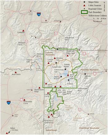
Because of its active volcanism, the Greater Yellowstone Ecosystem of Montana, Wyoming, and Idaho (Figure 1) is home to numerous obsidian sources utilized by Native Americans for more than 11,000 years (Figure 2). As such, the area was one of the richest regions in northwestern North America for Native Americans to collect toolstone. While much is known about the famous Obsidian Cliff obsidian source (Davis et al. Reference Davis, Aaberg and Schmitt1995; MacDonald Reference MacDonald2018), most Yellowstone lithic material sources are not well documented. The Cougar Creek obsidian source is one of the most obscure and least known in the park. In 2017, archaeological survey of the Cougar Creek and Madison River valleys east of West Yellowstone, Montana, documented Cougar Creek obsidian outcrops, procurement areas, and secondary processing sites. This article describes the results of survey, as well as the geographic and chronological distribution of Cougar Creek obsidian in the region.
Location of Yellowstone National Park.

Map of Yellowstone National Park and key sites and lithic material sources.

Determination of the factors involved in lithic procurement, use, and distribution by Native American hunter-gatherers is an important research goal for archaeologists (Andrefsky Reference Andrefsky1994a, Reference Andrefsky1994b; MacDonald Reference MacDonald2009; Nelson Reference Nelson and Schiffer1991; Schiffer Reference Schiffer1972; Shott Reference Shott1986). Following the lead of gravity models (Adams and MacDonald Reference Adams, MacDonald, Ozbun and Adams2015; Wilson Reference Wilson2007), this article introduces a quantitative assessment technique to compare seven obsidians commonly used by Native Americans over the last 11,000 years in the region. The study measures several quantitative and qualitative attributes of the toolstones to evaluate their differential procurement and use. By comparing various attributes of the obsidians using a weighted z-score formula, the reasons for their differential use become apparent, as does the organization of the lithic technology of Native American hunter-gatherers in Yellowstone. The assessment technique employs replicable variables that are adaptable to other regions with good information on toolstone source areas. For example, due to the highly variable terrain of the Yellowstone region, this study uses elevation as a measure of differential access to lithic sources, but other areas, such as desert or semidesert environments with lower relief, might select an attribute such as distance to springs or seeps as a major factor in lithic resource access.
The article employs an organization of technology approach to better understand human and artifact movements through the landscape, following the lead of Schiffer (Reference Schiffer1972), Binford (Reference Binford1979), Gould and Saggers (Reference Gould and Saggers1985), Nelson (Reference Nelson and Schiffer1991), and Andrefsky (Reference Andrefsky1994a, Reference Andrefsky1994b), among others (Eerkens et al. Reference Eerkens, Spurling and Gras2008; Jones et al. Reference Jones, Beck, Jones and Hughes2003; MacDonald Reference MacDonald, MacDonald, Andrefsky and Yu2014; Scheiber and Finley Reference Scheiber and Finley2011). The goal is to follow artifacts through their life cycles from material procurement through tool production, use, discard, and recycling, in order to better understand human behavior relative to lithic technology (Shott Reference Shott, Robinson and Sellet2018). One prediction of the article is that low-ranked Yellowstone obsidians were used mostly locally and expediently (and were not curated) while highly ranked obsidians were used extensively both locally and in distant areas due to increased curation (Andrefsky Reference Andrefsky1994b; MacDonald Reference MacDonald2009).
Background: Yellowstone Culture History, Geology, and Lithic Materials
Yellowstone Geography and Culture History
Yellowstone, the world's first national park (1872), is located within the states of Wyoming, Idaho, and Montana, within the Rocky Mountains and Great Plains region of the United States (Figure 1). Within the center of the park, Yellowstone Lake—at 341 km2 and 2,357 m above mean sea level (amsl)—is North America's largest natural high-elevation lake (Figure 2). The lake feeds the Yellowstone River, which is the largest natural free-flowing river in the United States. Mountain peaks stretching beyond 3,300 m amsl occur throughout the park. The Continental Divide is south and west of Yellowstone Lake. Yellowstone National Park and vicinity are underlain by a vast volcanic caldera (Figure 2), resulting in numerous hot springs, geysers, and thermal features, as well as dozens of locations of rhyolitic and basaltic magma flows, which contain obsidian useful in Native American stone tool manufacture.
Native Americans have lived in Yellowstone National Park for at least 11,000 years (Hale and Livers Reference Hale, Livers, MacDonald and Hale2013). Evidence of early Paleoindians before 10,000 BP is scarce (MacDonald and Nelson Reference MacDonald and Nelson2018). Based on Whitlock's (Reference Whitlock1993; Krause and Whitlock Reference Krause and Whitlock2013), research, among others’ (Davis Reference Davis1988; Elias Reference Elias1997; Lu et al. Reference Lu, Stone, Fritz and Westover2017; Pierce et al. Reference Pierce, Licciardi, Krause, Whitlock, Shaw and Tikoff2014), it was not until approximately 10,000 BP that the climate of Yellowstone Lake and surrounding mountains was warm and dry enough for colonization by plants, animals, and humans (Cannon and Hughes Reference Cannon and Hughes1997:102–103; MacDonald Reference MacDonald2018).
With ameliorating climatic conditions, human use of Yellowstone increased during the Late Paleoindian period after 10,000 BP. More than 50 sites in Yellowstone have evidence of Cody complex late Paleoindians (Johnson and Reeves Reference Johnson and Reeves2013; MacDonald and Nelson Reference MacDonald and Nelson2018; Nelson and MacDonald Reference Nelson and MacDonald2016). Human use of the park area increased steadily during the Early Archaic (8000 to 5000 BP) and Middle Archaic (5000 to 3000 BP) to a peak during the Late Archaic period (3000 to 1500 BP; MacDonald Reference MacDonald2012a:257, Reference MacDonald2018). During the Late Archaic, Native Americans actively collected Yellowstone obsidian to use in communal bison hunts, as well as to trade within the Hopewell Interaction Sphere. One mound of the Ohio Scioto Hopewell culture contained more than 300 lbs of obsidian from the Obsidian Cliff and Bear Gulch sources in the Yellowstone region (DeBoer Reference DeBoer2004; Hughes Reference Hughes1992, Reference Hughes, Charles and Buikstra2006). Native American tribes, including the Shoshone, Crow, Nez Perce, and Blackfeet, among others, continued to use Yellowstone obsidian throughout the Late Prehistoric period until the late nineteenth century (Nabakov and Loendorf Reference Nabakov and Loendorf2002, Reference Nabakov and Loendorf2004).
Yellowstone Geology and Lithic Raw Materials
Over the past 2.1 million years, active volcanism has played a pivotal role in shaping the Yellowstone region. The most recent volcanogenic cycle began more than 640,000 years ago with the pyroclastic eruption of the Lava Creek Tuff and was later frequented by massive rhyolitic and basaltic magma flows. Of particular importance to this study were isolated rhyolitic magma extrusions of the Roaring Mountain member of the Yellowstone Plateau volcanic field, including those at Cougar Creek and Obsidian Cliff, which both contain significant amounts of obsidian useful for Native Americans in stone tool manufacture (Christiansen Reference Christiansen2001; Christiansen and Blank Reference Christiansen and Blank1972; Watkins et al. Reference Watkins, Manga, Huber and Martin2009; Watts et al. Reference Watts, Bindeman and Schmitt2012).
In west-central Yellowstone, approximately 10 km northeast of the town of West Yellowstone, Montana, the 2.14 km2 Cougar Creek rhyolite dome erupted 399,000 years ago, while 25 km farther to the northeast, the 14.49 km2 Obsidian Cliff rhyolitic magma flow occurred 180,000 years ago. As shown in Figure 2, both of these magma extrusions occurred north of the limits of the Yellowstone caldera boundary but are linked to the system via subterranean magma chambers.
Obsidian Source Methodology
Lithic material sourcing is an indispensable tool employed by archaeologists to understand mobility and trade patterns of human populations (Hughes Reference Hughes and Hughes1984). Archaeologists and geoscientists of Yellowstone are fortunate to be able to chemically distinguish the various obsidian and dacite sources. During the mid-twentieth century, archaeologists used neutron activation analysis to identify the chemical composition of obsidians, such as the seminal work of Griffin and colleagues (Griffin Reference Griffin1965; Griffin et al. Reference Griffin, Gordus and Wright1969) for obsidian at Ohio's Hopewell mounds, as well as Frison and colleagues’ (Reference Frison, Wright, Griffin and Gordus1968) and Davis's (Reference Davis1972) research on obsidian use in Montana and the northwestern Plains. Developed in the late twentieth century, energy-dispersive X-ray fluorescence (ED-XRF) technology greatly increased the accuracy of volcanic rock source identifications (Hampel Reference Hampel and Hughes1984; Hughes Reference Hughes and Hughes1984; Shackley Reference Shackley1998).
The first Yellowstone artifacts subjected to ED-XRF analysis came from a survey project to ascertain the chemical makeup and distribution of Obsidian Cliff obsidian (Davis et al. Reference Davis, Aaberg and Schmitt1995). Since those initial ED-XRF studies, research in the last 30 years has identified several major obsidian source locations in and around Yellowstone, as shown in Figure 2. This study describes Native American use of Cougar Creek obsidian and compares it with the use of four regional obsidians, including Obsidian Cliff (Davis et al. Reference Davis, Aaberg and Schmitt1995), black Park Point (McIntyre et al. Reference McIntyre, MacDonald, Livers, Hughes, MacDonald and Hale2013), red Park Point (Pfau and MacDonald Reference Pfau and MacDonald2016), and Lava Creek (Pfau and MacDonald Reference Pfau and MacDonald2016) within Yellowstone, as well as two volcanic sources just outside of Yellowstone, Cashman dacite (Baumler et al. Reference Baumler, Helm, Platt, Rennie and Wilmouth2001) and Bear Gulch obsidian (Raley Reference Raley2011). Bear Gulch is occasionally referred to as Big Table Mountain obsidian (Willingham Reference Willingham1995). Several additional obsidian sources are present in the region, mainly to the west and south of Yellowstone (see Figure 2).
Cannon and Hughes (Reference Cannon and Hughes1993, Reference Cannon and Hughes1997) and Baumler (Reference Baumler1997) were among the first to synthesize ED-XRF data for meaningful interpretations of hunter-gatherer land-use patterns in the Yellowstone region. Subsequently, Bohn (Reference Bohn2007), Park (Reference Park2010, Reference Park, MacDonald and Hale2011), and Wunderlich (Reference Wunderlich2014) conducted thesis research of ED-XRF data to understand toolstone selection by Native Americans in the region. Johnson and Reeves (Reference Johnson and Reeves2013) studied obsidian use by Native Americans during the Late Paleoindian period, while Sanders (Reference Sanders, MacDonald and Hale2013) examined toolstone use in the Hayden Valley region of Yellowstone. Scheiber and Finley (Reference Scheiber and Finley2011) and Finley and colleagues (Reference Finley, Boyle and Harvey2015) analyzed lithic sourcing data in northwestern Wyoming and adjacent regions, while Reckin and Todd (Reference Reckin and Todd2019) studied obsidian use in the Absaroka and Beartooth Ranges east of Yellowstone.
In addition to these prior studies, this study has amassed more than 1,300 artifact source identifications from 27 different University of Montana projects to better understand hunter-gatherer mobility and trade networks in the region (Adams and MacDonald Reference Adams, MacDonald, Ozbun and Adams2015; MacDonald Reference MacDonald2012a, Reference MacDonald, MacDonald, Andrefsky and Yu2014; MacDonald and Hale Reference MacDonald and Hale2013; MacDonald and Nelson Reference MacDonald and Nelson2018; MacDonald et al. Reference MacDonald, Gish and Hughes2011; MacDonald et al. Reference MacDonald, Gish, Sheriff and Livers2012). The basic conclusion of this research is that multiple Native American hunter-gatherer groups from different regions—including the Snake River Plain to the south and west, the Rocky Mountains surrounding Yellowstone, and the Great Plains to the north and east—visited Yellowstone over at least 11,000 years. As reviewed by MacDonald (Reference MacDonald2012a, Reference MacDonald, MacDonald, Andrefsky and Yu2014, Reference MacDonald2018; MacDonald and Nelson Reference MacDonald and Nelson2018), these patterns of land use started soon after glaciers receded in this area and continued until the nineteenth century. The Yellowstone region was a significant regional attraction during the entire Holocene due to its abundant natural resources, including obsidian, which drew multiple Native American tribes from different regions (MacDonald Reference MacDonald, MacDonald, Andrefsky and Yu2014).
Prior work by the University of Montana has described and/or enhanced knowledge regarding several types of lithic raw materials in Yellowstone, including Crescent Hill chert (Adams Reference Adams2011; Adams and MacDonald Reference Adams, MacDonald, Ozbun and Adams2015) and black Park Point obsidian (McIntyre et al. Reference McIntyre, MacDonald, Livers, Hughes, MacDonald and Hale2013). Recent fieldwork located outcrops of rock that were previously unidentified in the literature, including Lava Creek Tuff obsidian in the Lewis River valley (Pfau and MacDonald Reference Pfau and MacDonald2016), orthoquartzite at Yellowstone Lake (MacDonald Reference MacDonald2013), and red Park Point obsidian along the Snake River (Pfau and MacDonald Reference Pfau and MacDonald2016). In the same vein, the current study describes the geography, geology, and chronology of use of Cougar Creek obsidian.
Archaeological Survey of the Cougar Creek Rhyolite Dome
Prior Archaeology at Cougar Creek
The Cougar Creek obsidian source is located approximately 10 km northeast of West Yellowstone, Montana, just across the state line in Wyoming. Cougar Creek flows along the northern edge of the rhyolite dome, feeding into the Madison River 2 km southwest of the source. Gneiss and Maple Creeks are significant nearby tributaries of the Madison River as well.
The Cougar Creek obsidian flow was originally visited in 1988 by former Yellowstone National Park archaeologist Ann Johnson. Richard Hughes (Reference Hughes1991) was the first to conduct ED-XRF analysis of the source samples, although the precise location of the sample's procurement is unknown. Cannon and Hughes (Reference Cannon and Hughes1997:103) were the first to mention the Cougar Creek obsidian source in a research article, with results of their sourcing studies from Norris and Yellowstone Lake included in that study (Hughes Reference Hughes1995). The Cougar Creek source was visited again in the late 1990s by Ann Johnson and Mack Shortt of the Montana State University Museum of the Rockies (Shortt and Johnson Reference Shortt and Johnson1999). Following these initial visits, Skinner (Reference Skinner and Shortt1999) procured a hand sample of Cougar Creek obsidian to analyze its elemental characteristics via ED-XRF analysis. Follow-up archaeological surveys by Shortt (Reference Shortt2000), Sanders and Wedel (Reference Sanders and Wedel2003), and Johnson and colleagues (Reference Johnson, Thorson, Mitchell and Shortt2006) in the Madison River valley (2–10 km south of the dome) were among the first to identify Cougar Creek obsidian in archaeological assemblages near the quarry area.
Description of the Cougar Creek Obsidian Quarries
Since these initial visits to the quarry and vicinity, no additional work was conducted at Cougar Creek until the current study in summer 2017. This project was funded by the National Park Service to analyze the effects on archaeological sites of the 2016 Maple Fire, which burned 183.4 km2 surrounding Cougar Creek. The project included a systematic archaeological study of the 2 km2 Cougar Creek rhyolite dome, as well as the nearby Gneiss Creek, Cougar Creek, and Madison River valleys.
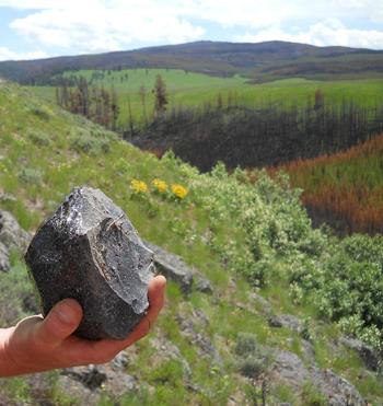
Archaeological research of the Cougar Creek rhyolite dome identified two primary obsidian procurement locations, as well as a third, inferior outcrop, that were used by Native Americans. These areas were identified as Quarry Area 1 (48YE2469), Quarry Area 2 (48YE2475), and Quarry Area 3 (48YE2472). The obsidian in these areas is dark black, opaque, and of a variable quality for flintknapping (Figure 3). Cougar Creek obsidian contains mostly smooth, glassy textures with an open matrix of spherulites composed of one or more anhydrous minerals ranging between 0.1 mm and 1.0 mm in diameter. The quarry areas contain abundant lithic production debris associated with obsidian cobble reduction activities (Supplemental Table 1). Some higher-quality cobbles have few phenocrysts and inclusions, while other cobbles are riddled with them. Observed artifacts reflect that Native Americans widely tested the material to select the highest-quality pieces for stone tool production. Large natural cobbles and boulders of obsidian are present at the Cougar Creek quarry areas, in comparison with some of the other minor obsidian sources in Yellowstone in which only very small hand-sized cobbles and pebbles are available, such as Park Point at Yellowstone Lake (McIntyre et al. Reference McIntyre, MacDonald, Livers, Hughes, MacDonald and Hale2013).
Cougar Creek obsidian within Quarry Area 1 (48YE2469), view east. Photo by Douglas MacDonald.

Quarry Area 1 occurs at the base of the dome's southern escarpment at an elevation of 2,075 m amsl, within a narrow valley cut by a perennial spring and creek (Figure 3). Obsidian outcrops and evidence of prehistoric quarry activity are present within a 555 m × 505 m area on the lower half of the dome's south-facing slope. Flaking debris and tested cobbles, among other obsidian artifacts, are densely concentrated along the entire slope, especially in the vicinity of several large rhyolite boulders. Native Americans apparently utilized the large boulders as stone tool production stations. Analysis of collected artifacts indicates that obsidian testing, core reduction, and early-stage biface manufacture were the main stone tool production activities in Quarry Area 1.
One circular pit, 1 m in diameter, was excavated by Native Americans into the base of the slope on the far southwest edge of Quarry Area 1. A hand-sized hammerstone, located on the edge of the pit, was likely used for testing obsidian cobbles. ED-XRF analysis of all nine natural (unmodified) and 11 cultural (artifact) samples collected along an east-west transect matched the Cougar Creek chemical composition (Hughes Reference Hughes2018).
Approximately 1.5 km to the north, Quarry Area 2 (48YE2475) contains abundant obsidian flaking debris and tested cobbles within an area measuring approximately 300 m × 260 m along the northwestern rim of the Cougar Creek dome. Two prehistoric Native American obsidian quarry features were observed here, consisting of a trench and a pit. Dense vegetation cover of grasses and lodgepole pine may obscure the locations of additional pits and trenches. Of a total of 21 obsidian samples collected from Quarry Area 2, 14 were submitted for ED-XRF sourcing to Hughes (Reference Hughes2018), with all of them matched to the Cougar Creek source. Collected artifacts are predominantly flaking debris from the early stages of core and biface manufacture, with most flakes retaining geologic cortex.
Approximately 250 m east of Quarry Area 2, Quarry Area 3 (48YE2472) is located on the north-central top edge of the rhyolite dome. This area contains large rhyolite boulders with veins of phenocryst-rich obsidian, inferior in quality to obsidian in Quarry Areas 1 and 2. The low density of archaeological debris in this area suggests that the poor quality of the obsidian dissuaded collection by Native Americans. Fifteen artifacts from Quarry Area 3 were submitted for ED-XRF sourcing, each of which was identified as Cougar Creek obsidian (Hughes Reference Hughes2018).
The obsidian in the three procurement areas at Cougar Creek is indistinguishable via ED-XRF analysis, thus any artifacts sourced back to Cougar Creek could derive from any of the three outcrops. Quarry Areas 1 and 2 represent Cougar Creek obsidian quarry areas used extensively for stone tool manufacture, including the excavation of trenches and pits to obtain obsidian.
Native American Use of Cougar Creek Obsidian
Geographic Distribution of Cougar Creek Obsidian at Regional Archaeological Sites
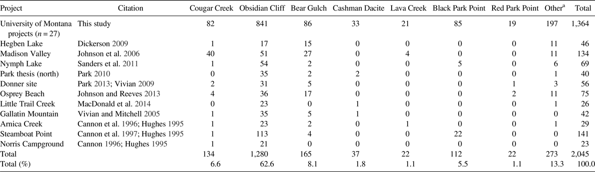
To better understand the scope of Native American use of Cougar Creek obsidian in prehistory, this study examined obsidian distributions (site and source) for 681 lithics from 11 previous projects (Table 1). To bolster the obsidian source sample, the study includes 1,364 sourced volcanic lithic artifacts recovered from 27 projects conducted by the University of Montana in Yellowstone between 2007 and 2017. These artifacts derive largely from subsurface excavations but also include several from surface contexts as well. In total, the study includes ED-XRF source data for 2,045 lithic artifacts from 38 projects across the region, summarized in Table 1.
Summary of Energy Dispersive X-Ray Fluorescence Results from Sourcing Projects in the Yellowstone Region Used in This Study.

a Obsidians represented in the “Other” category include Teton Pass (n = 69), unknown obsidian/tuff (n = 39), Crescent H (n = 31), Packsaddle Creek (n = 29), Conant Creek (n = 27), Warm Creek (n = 21), unknown dacite (n = 17), Reas Pass (n = 10), Malad (n = 7), Huckelberry Ridge Tuff (n = 5), Grasshopper Knob (n = 4), West Gros Ventre (n = 3), Big Southern Butte (n = 2), Gibbon Falls (n = 2), and Timber Butte (n = 1).
Local Use of Cougar Creek Obsidian
The majority of sites recorded within the Madison River valley and tributaries near the Cougar Creek source contain evidence of its use. Based on the results of several local projects (Sanders and Wedel Reference Sanders and Wedel2003; Shortt Reference Shortt2000; Shortt and Johnson Reference Shortt and Johnson1999; Shortt and Mitchell Reference Shortt and Mitchell2000), Johnson and colleagues (Reference Johnson, Thorson, Mitchell and Shortt2006) analyzed 134 obsidian artifacts from within 10 km of the source.
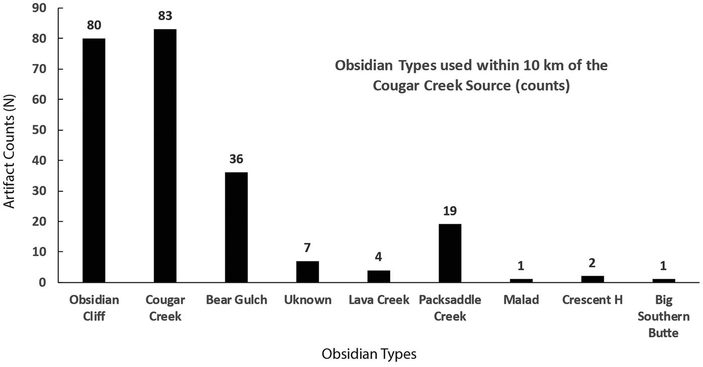
This study added ED-XRF analysis of 99 non-quarry-area artifacts from 10 sites within 10 km of the rhyolite dome. Of the 233 sourced artifacts from local Cougar Creek area sites (Figure 4), nearly as many (n = 80; 34.3%) were sourced to Obsidian Cliff as to Cougar Creek (n = 83; 35.6%). Bear Gulch (n = 36; 15.5%) and Packsaddle Creek (n = 19; 8.2%) are also well represented (see Figure 2 for source locations). These local source-area data indicate that Native Americans collected Cougar Creek obsidian at the source areas and transported it into the Cougar Creek, Gneiss, Maple, and Madison River valleys for stone tool manufacture but also curated high numbers of nonlocal obsidian tools as well.
Types of obsidian used in proximity (within 10 km) of the Cougar Creek quarry area.

Nonlocal Use of Cougar Creek Obsidian
While Cougar Creek obsidian was actively used by hunter-gatherers within 10 km of the source, Native Americans did not transport the material for significant distances beyond the source area. University of Montana research between 2007 and 2016 ED-XRF-sourced 1,225 artifacts distributed across all of Yellowstone National Park, with none returning a Cougar Creek source signature. Our research only identified Cougar Creek artifacts (n = 82) during our 2017 study near the source. For all of the projects conducted outside of the local source area (beyond 10 km of the source), archaeologists have identified only 13 (0.68%) Cougar Creek artifacts out of the 1,923 nonlocal (>10 km distant) artifacts included in the study (Supplemental Table 2). Of these artifacts, most derive from points eastward, including the Norris area (25 km northeast of the Cougar Creek source) and Yellowstone Lake (50–100 km southeast of the source; see Figure 2). The farthest site with Cougar Creek obsidian from the source is the Donner site on the Southeast Arm of Yellowstone Lake (90 km southeast). This site yielded Middle and Late Archaic projectile points of the material (Shortt Reference Shortt2001:43, 45; also see Johnson Reference Johnson2003).
While it was limited in use, the geographic distribution of Cougar Creek obsidian indicates lithic conveyance by Native Americans east-west within the Madison River valley to and from Yellowstone Lake, as well as north-south to and from Obsidian Cliff. The presence of extensive amounts of Obsidian Cliff obsidian in archaeological sites surrounding Cougar Creek and within the nearby Madison River valley supports this assertion as well.
This study's conclusion of limited Native American use of Cougar Creek obsidian beyond the local area is supported by other regional obsidian studies. Baumler's (Reference Baumler1997) study of 214 obsidian artifacts at Flying D Ranch near Bozeman, Montana (125 km northwest of Cougar Creek), did not identify any obsidians other than Obsidian Cliff, Bear Gulch, Malad, and Timber Butte. Scheiber and Finley's (Reference Scheiber and Finley2011) study of 1,129 lithics from sites in northwestern Wyoming, as well as 463 from sites in southwestern Montana, did not identify any artifacts produced from Cougar Creek obsidian. Finley and colleagues (Reference Finley, Boyle and Harvey2015) did not find any Cougar Creek obsidian in their analysis of 864 lithics in the Wyoming Basin area (southeast of Yellowstone). Finally, Reckin and Todd's (Reference Reckin and Todd2018) study of 994 lithic artifacts from the Absaroka Mountains and 360 artifacts from the Beartooth Mountains (east of Yellowstone) also lacked any artifacts sourced to Cougar Creek.
Distance Decay of Cougar Creek and Obsidian Cliff Obsidian
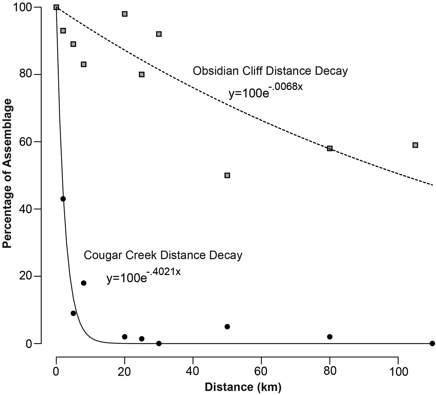
To analyze the distance decay of Cougar Creek obsidian further (cf. Brady Reference Brady2011; Eerkens et al. Reference Eerkens, Spurling and Gras2008; Zeitlin Reference Zeitlin1982), this study summarizes use of the material at various distances from the source in comparison with similar data for Obsidian Cliff (see Supplemental Table 3 for distance decay data). The selected intervals were largely dictated by the availability of lithic source data at investigated sites in the region. Figure 5 shows the exponential distance decay graphs for Cougar Creek and Obsidian Cliff obsidian.
Distance decay graphs for Cougar Creek and Obsidian Cliff obsidian (see Supplemental Table 3 for distance decay data).

The distance decay for Cougar Creek obsidian is very steeply negative, with a distance decay of 33.1% per kilometer. For Obsidian Cliff, as shown in Figure 5, the exponential distance decay line is negatively sloped but is not nearly as steeply negative as Cougar Creek's, with a decline of only 0.68% per kilometer. These data indicate that Native American hunter-gatherers continued to actively use the material even at significant distances from the source area. For example, the Mummy Cave site is 105 km southeast of the cliff, and it contained 43 (59%) Obsidian Cliff artifacts of 73 total. In contrast, Mummy Cave did not yield any Cougar Creek obsidian artifacts, despite it being approximately equidistant from that site as from Obsidian Cliff (Hughes Reference Hughes2005).
Comparison of the quarry activity at the two source areas—Cougar Creek and Obsidian Cliff—also reflects their differential use in prehistory. Whereas only three pits and trenches are present in the small procurement areas at Cougar Creek, at least 59 much larger pits and trenches are present across the 14.5 km2 Obsidian Cliff (Davis et al. Reference Davis, Aaberg and Schmitt1995; MacDonald Reference MacDonald2018). While Cougar Creek obsidian was a local stone used nearly exclusively in close proximity to the source, Obsidian Cliff obsidian was a commodity in high demand for people well beyond Yellowstone. These differences translated into intensive quarry activity at Obsidian Cliff compared with only minimal quarrying at Cougar Creek.
Chronology of Cougar Creek Obsidian Use
Examination of the use of Cougar Creek obsidian across the region—at both local and nonlocal (>10 km) sites—facilitates an understanding of its chronological use in prehistory as well. A total of 15 Cougar Creek artifacts provide information on its period of use in the region (Supplemental Table 4). Diagnostic artifacts from local and regional sites reflect an initial use of Cougar Creek obsidian during the Late Paleoindian period (n = 4), approximately 9,500 to 9,000 years ago. Ephemeral use of the material occurred between 8,000 and 3,000 years ago, during the Early Archaic (n = 1) and Middle Archaic periods (n = 2). As with many other lithic source areas in the Plains and Rockies (Davis et al. Reference Davis, Aaberg and Schmitt1995; MacDonald Reference MacDonald2018), the Late Archaic period (n = 7)—from 3,000 to 1,500 years ago—was the dominant period of Cougar Creek obsidian use. This intensification occurred on two fronts during the Late Archaic period, including stone procurement for trade in the Midwestern Hopewellian Interaction Sphere as well as increased projectile point production for local and regional communal bison hunting (MacDonald Reference MacDonald2012b:121–122). The result was an increasing desire for all kinds of lithic material during this time, including widely popular obsidians such as Obsidian Cliff and Bear Gulch, as well as more obscure obsidians such as Cougar Creek.
Comparative Analysis of Native American Toolstone Selection in Yellowstone
Why did Native Americans prefer Obsidian Cliff obsidian over Cougar Creek obsidian in such a consistent way for 11,000 years? How does Native American use of Cougar Creek obsidian compare with their use of other regional obsidians? Prior research in Yellowstone has been conducted to better understand the universe of toolstone and how Native Americans made decisions on its procurement, production, use, and distribution. This prior work used gravity models (Wilson Reference Wilson2007) to understand the value, or attractiveness, of lithic raw materials found at two other lithic sources in Yellowstone, including the Crescent Hill chert source (Adams and MacDonald Reference Adams, MacDonald, Ozbun and Adams2015) and the Park Point black obsidian source (McIntyre et al. Reference McIntyre, MacDonald, Livers, Hughes, MacDonald and Hale2013). Following Andrefsky (Reference Andrefsky1994a, Reference Andrefsky1994b) and Schiffer (Reference Schiffer1972), Wilson (Reference Wilson2007) notes that there are four aspects associated with the exploitation of a raw material, including procurement, transportation, use, and abandonment. Her (2007:388–389) model is designed to rank the attractiveness of a lithic source based on the factors involved with procurement and transport of the source material. The model takes into account the quality and availability of the material, the location and difficulty of reaching the source, and the size of individual cobbles/stones and the outcrop/source location.
Description of the Quantitative Assessment Method
This study endeavors to devise a more robust tool to compare obsidian selection by hunter-gatherers in Yellowstone. The analysis is not dependent on distance-to-source calculations from sites (as per Wilson's model) but instead is an overall measure of each material's attractiveness for Yellowstone hunter-gatherers. Seven lithic sources were selected due to the availability of good provenance and material descriptions: Cougar Creek obsidian, Obsidian Cliff obsidian, Bear Gulch obsidian, Cashman dacite, Lava Creek (Grassy Lake source) obsidian, Park Point obsidian (black), and Park Point obsidian (red). A weighted z-score analysis is proposed to quantify and compare the various attributes of the seven material sources. In a weighted z-score analysis, the various measured attributes are collectively valued for each material source and then compared with each other, with higher scores indicating superior materials.
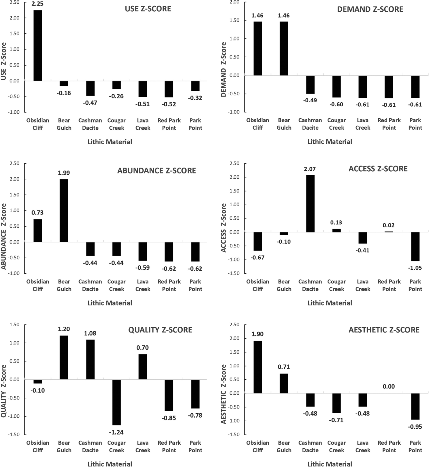
This study conducted 8 z-score analyses using a total of 10 attributes for each of the 7 obsidian varieties (Table 2). The first two analyses—USE and DEMAND—are not included in the final weighted z-score analysis but are provided to show the comparative usage of the seven materials in the Yellowstone region. USE combines the number of projects in the study that contain the material in question (presence/absence) with the total number of artifacts sourced to that location in the projects. The z-score for USE was weighted 50% for each variable. Demand for the material (DEMAND) was measured as the maximum distance (in kilometers) traveled by the stone from the source to a site in the archaeological record. The USE and DEMAND analyses are intended to provide an initial basis by which to judge the value of each of the seven materials to Native Americans in prehistory.
Lithic Material Attribute Data Used in Z-score Calculations.

a Use value used in the z-score (Table 8) is a weighted z-score with number of projects and total count each weighted 50%.
b Maximum distance is distance from geologic source to furthest archaeological site in which it occurs, based on references cited.
c Value was inverted by subtracting elevation from 3,000 so that the material sources with the lowest elevations would be ranked highest.
d Value was inverted by subtracting distance to river from 50 so material sources with reduced distances would be ranked highest.
e Fe-Mn ratio was inverted by subtracting from 100, so lower values resulted in higher z-scores (e.g., higher quality).
The remaining four z-score analyses of seven material attributes were combined in the weighted z-score analysis to determine the reasons for selection of the obsidians by hunter-gatherers in prehistory. ABUNDANCE was measured as the area (km2) encompassed by the source material at the geologic source. A proxy measure of ACCESS was determined by the elevation of the source (m amsl) relative to its distance (km) to the nearest major river. Prior research has shown that major rivers were the primary travel corridors used by Native American hunter-gatherers in Yellowstone (MacDonald Reference MacDonald, MacDonald, Andrefsky and Yu2014). Because z-score values have higher scores as positive attributes, the material source elevations were inverted by subtracting the elevation from 3,000 m, while the distances from major rivers were inverted by subtracting from 50, thus making the lower-elevation sources and those closer to rivers more highly ranked (e.g., easier to access). The ACCESS z-score was calculated using 50% weights for both elevation and distance to a major river.
Determined in consultation with Richard Hughes (personal communication Reference Hughes2018), quality of the obsidian (QUALITY) was assessed using the ratio of iron (Fe) to manganese (Mn) for each of the materials, with higher Fe/Mn ratios reflecting volcanic glasses containing greater amounts of inclusions and phenocrysts and, thus, of comparatively inferior toolstone quality. Each material was analyzed for the quantity and sizes of inclusions and phenocrysts as well, using a scale of 1–10 (with 10 being the most pure). The QUALITY z-score was weighted 75% Fe:Mn ratio and 25% subjective quality determination, with higher scores indicating increased purity and stone quality for stone tool manufacture. Finally, an AESTHETIC value was attributed to each source based on the variety of colors available for the material (with more varieties of colors stipulated as a positive aesthetic attribute), as well as our subjective evaluation of each material's attractiveness as a material for making stone tools, using a 1–10 scale (with 10 being the most attractive material). Colors and attractiveness were weighted 50% in the z-score analysis.
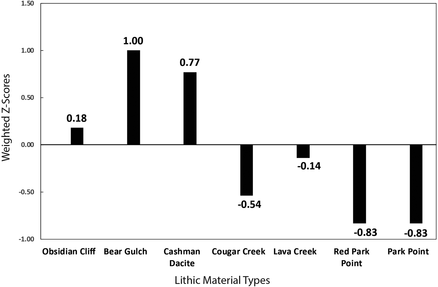
Each of the lithic sources was measured for its ABUNDANCE, ACCESS, QUALITY, and AESTHETIC attributes (Table 2), with the values converted into z-scores that compare each source material's scores against the mean and the standard deviation of the scores in the category. This results in a z-score between approximately −1 and + 2 for each lithic material for each category. Higher scores in each category are considered favorable. Next, each variable was put in a formula to derive a total weighted z-score, which combines all of the variables. Higher weighted z-scores indicate superior materials overall compared with the others in the analysis. The weighted z-score formula includes 30% weights for ABUNDANCE, ACCESS, and QUALITY. Since AESTHETIC is the most subjective attribute of the analysis, its weight is reduced (10%) in the final weighted z-score calculation.
Use and Demand of Yellowstone Obsidian
In terms of use and demand, Obsidian Cliff obsidian is far and away the most popular of the seven materials, with Bear Gulch obsidian showing strong demand but reduced use. As explored more below, these differences in the use of the two top-ranked lithic materials are likely due to proximity to source, rather than material attributes favored by regional hunter-gatherers.
The other five lithic materials, including Cougar Creek obsidian, show quite low use and demand. Cougar Creek's regional usage rate is very low, with few sites beyond the nearby Madison River valley containing the material. The demand for the material is second-lowest, with the most distant site being less than 90 km from the source location. Since all of the other lithic materials in this study (except Cashman dacite and Bear Gulch obsidian) occur in Yellowstone National Park, the high usage rates of Obsidian Cliff obsidian compared with the other obsidians in the sample are likely due to material attribute differences, as explained in the quantitative assessment method results below.
Results of the Quantitative Assessment Method
The quantitative assessment model results provide clear indicators as to why Obsidian Cliff as well as Bear Gulch obsidians were so highly valued by Native American hunter-gatherers. Within the analysis, values were converted into z-scores for each attribute by subtracting the mean of the attribute data and dividing that value by the standard deviation. Table 2 shows the raw data utilized in calculating the z-score values. Figure 6 shows the results of each of the six z-score analyses, while Figure 7 shows the results of the weighted z-score analysis.
Results of individual z-score analyses for the six categories of material attributes.

Results of weighted z-score calculations for lithic materials in the study.

In nearly every z-score analysis of the lithic material attributes, as well as in the weighted z-score analysis, Obsidian Cliff and Bear Gulch obsidians, as well as, to a lesser extent, Cashman dacite, rank very highly compared with the other lithic materials. Second only to Bear Gulch (28 km2; Willingham Reference Willingham1995:3), Obsidian Cliff is one of the largest of the measured quarries (15 km2) and is also abundant in total volume of material at the source location (MacDonald Reference MacDonald2018). Bear Gulch and Cashman dacite rank highest in quality, with Obsidian Cliff ranking in the middle of the seven obsidians. Obsidian Cliff ranks highest in aesthetic attributes, as it occurs in the most color variations (n = 5) and was ranked as the best obsidian for the production of stone tools. Again, in the weighted z-score analysis, this variable is weighted at only 10% due to its subjectivity. This low contribution is likely the cause of Obsidian Cliff obsidian's reduced weighted z-score compared with Bear Gulch obsidian and Cashman dacite. However, it also indicates that the aesthetic qualities of Obsidian Cliff obsidian may have been quite important to Yellowstone hunter-gatherers in its selection over other available lithic materials.
Interestingly, access was the only category in which Obsidian Cliff and Bear Gulch obsidians ranked poorly. Obsidian Cliff's elevation is high compared with that of other sources, as is its distance to a major river; thus, hunter-gatherers expended more effort to travel to Obsidian Cliff and Bear Gulch than to travel to nearly all of the other sources. However, the obsidians’ superior quality, abundance, and aesthetic appeal counteracted any difficulty in access, leading Native Americans to use those two toolstones more than the others. These material qualities also likely inspired prehistoric trade and transport of Obsidian Cliff and Bear Gulch obsidians across North America during the Late Archaic period (DeBoer Reference DeBoer2004; Hughes Reference Hughes1992, Reference Hughes, Charles and Buikstra2006).
Cougar Creek's overall ranking in the weighted z-score analysis is in the lower middle of the other obsidians. It ranks comparatively highly in abundance, covering 2 km2, but with only two small outcrops of obsidian. Access to the Cougar Creek quarries is also moderate, with a slightly higher elevation than most sources but within an easy 2 km walk north of the Madison River, a major tributary of the Missouri River. While the quality of the rock is better than that of many of the other regional obsidians, it still contains large numbers of phenocrysts and inclusions compared with strains of the relatively pure obsidian from Obsidian Cliff and Bear Gulch. Finally, Cougar Creek obsidian's aesthetic qualities are ranked second to last among the stones due to a lack of color variation, as well as the large number of impurities observed in samples at the quarry areas.
Summary and Conclusion
This study of Cougar Creek obsidian accomplished several important research goals, including the introduction of a quality assessment technique to compare seven obsidians commonly used by Yellowstone Native Americans. Using a weighted z-score analysis, Cougar Creek obsidian was compared with six regional toolstones to determine the factors involved in their differential use. Based on this analysis, there are at least three prominent, widely used regional toolstones that Native Americans likely went out of their way to obtain, including Obsidian Cliff obsidian, Bear Gulch obsidian, and Cashman dacite. These stones are abundant, are high quality, and have high aesthetic rankings. In contrast, the four other obsidians in the study, including Cougar Creek, Lava Creek, and the two varieties of Park Point (red and black), are poorly ranked in most categories.
The low-ranked stones were likely collected in a casual or expedient manner by Native Americans (Andrefsky Reference Andrefsky1994b), without the major quarrying and travel required for the top-ranked materials. Following Binford (Reference Binford1979; Gould and Saggers Reference Gould and Saggers1985), the highly ranked obsidians were likely directly procured for the most part, whereas collection of the other materials, including Cougar Creek, was likely embedded within a broader cultural system in which nonlithic resource acquisition—such as hunting, gathering, and social issues—was a higher priority. Ultimately, this resulted in widespread distribution and high usage rates for the top three toolstones, compared with reduced demand and distribution beyond their local source areas for the other, poorly ranked obsidians, including Cougar Creek.
In addition to the quality assessment technique, this study describes the Cougar Creek obsidian source for the first time and confirms its chemical composition as first established by Hughes (Reference Hughes1991) and Skinner (Reference Skinner and Shortt1999). The study describes the geologic contexts of Cougar Creek obsidian within the Roaring Mountain member of the Yellowstone Plateau volcanic field, identifying three areas of procurement, which are indistinguishable from each other by ED-XRF analysis; thus, artifacts sourced back to Cougar Creek could come from any one of the procurement areas at the rhyolite dome.
The study also evaluates the distribution of Cougar Creek obsidian within the Yellowstone region, concluding that its use decreased precipitously within a short distance of its Madison River valley source. Usage of Cougar Creek was fairly active in close proximity to the point source. However, Native Americans decreased their use as they moved away, signifying reduced demand due to its comparatively low-moderate quality and availability compared with other regional obsidians and sources. Only 13 Cougar Creek obsidian artifacts have been found at sites greater than 10 km from the source, and of those, eight are from sites on the south shore of Yellowstone Lake. This indicates regular movement of people between the Madison River valley and Yellowstone Lake during most of prehistory. The presence of abundant Obsidian Cliff obsidian at Madison River valley sites near Cougar Creek also suggests regular north-south movements between the two areas. Finally, significant amounts of Bear Gulch and Packsaddle Creek obsidian in Madison Valley sites also suggests stone transport into Idaho and the Snake River Plain west of Yellowstone. These data confirm prior research that multiple Native American hunter-gatherer groups visited Yellowstone from various regions (MacDonald Reference MacDonald, MacDonald, Andrefsky and Yu2014; MacDonald et al. Reference MacDonald, Gish, Sheriff and Livers2012:238–239 ).
Starting in the Late Paleoindian period, Native American hunter-gatherers collected Cougar Creek obsidian at least occasionally for 9,500 years. The Late Archaic period—3,000 to 1,500 years ago—witnessed the most intensive period of use, likely associated with stone procurement for the intensification of bison hunting as well as for trade in the Hopewellian Interaction Sphere. The low numbers of Late Prehistoric artifacts perhaps indicate a change in territorial movements and lithic material procurement in the last 1,500 years. Scheiber and Finley (Reference Scheiber and Finley2011), MacDonald and colleagues (Reference MacDonald, Gish, Sheriff and Livers2012), and Wunderlich (Reference Wunderlich2014) note similar changes in Late Prehistoric material and land use that are worthy of further exploration but remain unresolved in the current article.
The high quality, abundance, and aesthetic value of Obsidian Cliff and Bear Gulch obsidians resulted in increased local, regional, and national use by Native Americans. In contrast, Cougar Creek obsidian was of limited value to Native Americans and was procured only when necessary to meet short-term needs in proximity to the source. It was not the type of stone that traveled far, and it was quickly discarded upon the realization that other, higher-ranked materials were available on the landscape. Despite its low ranking compared with other major obsidians of the region, analysis of the usage of Cougar Creek obsidian facilitates a better understanding of Native American decision-making processes surrounding stone procurement, use, and distribution in Yellowstone.
The proposed quantitative assessment technique will be useful to researchers in other regions with data on lithic raw material sources, including the Great Basin and California in North America, among other places. The formula is easily amended for different regions, which might require additional environmental, geographic, or geologic variables. For example, in desert or semidesert environments, distance to springs and seeps (rather than elevation or distance to rivers) might be a more important variable in determining the usage rates of lithic material sources by hunter-gatherers. The proposed technique may also inspire the collection of consistent data at lithic raw material sources so that additional quarry areas can be incorporated into the model. In that vein, future survey and analysis of undocumented obsidian source areas in the Yellowstone region, including several in the Snake River valley and Teton Mountains, will provide data by which to more fully compare Native American obsidian use across the Greater Yellowstone Ecosystem and beyond.
Acknowledgments
Thanks go to Richard Hughes for conducting the energy dispersive X-ray fluorescence analysis for the Yellowstone projects included in this study. Thanks also go to Ann Johnson, Elaine Hale, Staffan Peterson, Tom James, and Tobin Roop for their work on these various projects. We would like to thank the University of Montana Department of Anthropology, as well as Yellowstone National Park, for providing resources for the completion of this research. The research was conducted under National Park Service grant P17AC00672 to the University of Montana. Thanks go to Brandon Bachman, Matt Nelson, Caleb Sobczak, Collin Price, Sean Flynn, Otto MacDonald, and Monte White for their participation in archaeological research for the project. Matt Nelson participated in lab and map work on the project. We intentionally left specific site and quarry area locations out of the article to prevent unauthorized artifact collection, which is illegal on federal land in accordance with the National Historic Preservation Act of 1966, the Archaeological Resources Protection Act of 1979, and the Antiquities Act of 1906. Interested researchers are encouraged to contact cultural resources staff at Yellowstone National Park to obtain more specific quarry locations and/or to gain access to the Cougar Creek quarry area. Finally, we appreciate the comments and edits suggested by the four anonymous reviewers and editor Lynn Gamble.
Data Availability Statement
All original data presented in this article can be obtained by contacting the lead author.
Supplemental Materials
For supplementary material accompanying this article, visit https://doi.org/10.1017/aaq.2018.76.
Supplemental Table 1. Lithic Analysis Results of Artifacts Collected at the Cougar Creek Quarries.
Supplemental Table 2. List of All Identified Artifacts Produced from Cougar Creek Obsidian beyond 10 km from the Source.
Supplemental Table 3. Distance Decay Data.
Supplemental Table 4. List of Cougar Creek Artifacts with Chronology Information.