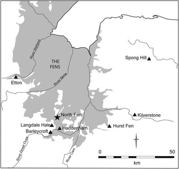


Over the last decade, Neolithic pits and ‘pit sites’ have taken centre stage within the wider discourse on Neolithic occupation and the character of its settlement (see eg Anderson-Whymark & Thomas Reference Anderson-Whymark and Thomas2012). However, whilst pit deposition and the cultural and ideological importance of pits have come to the fore, all too often the evidence is placed within a rather broadly defined settlement context based on models of residential or ‘tethered’ mobility, which it can be argued have not been developed accordingly (Whittle Reference Whittle1997; Pollard Reference Pollard1999). Underlying this is the ongoing debate, which runs deep within Neolithic studies, regarding the relative ‘permanence’ of Neolithic occupation and the degree to which populations were sedentary or conversely mobile (eg, Rowley-Conwy Reference Rowley-Conwy2004 vs Thomas Reference Thomas2004). With this in mind, an Early Neolithic pit site and artefact scatters excavated in 2010 by the Cambridge Archaeological Unit (CAU) at North Fen, Sutton Gault, Cambridgeshire (Fig. 1), provides an opportunity to attempt to more closely define the character of Early Neolithic settlement at an individual site and to consider how it relates to activity within the wider landscape.
Site location

Situated within former fenland, the North Fen ‘island’ is located within a landscape which has seen extensive archaeological investigation. As such, it is important to note from the outset that although on a map of regional archaeology the area appears as a concentration of Neolithic sites, this is almost certainly the result of the scale of archaeological work undertaken, rather than representing an atypical focus of Neolithic activity. Instigated by the Fenland Project (Hall Reference Hall1996) and the excavations at Haddenham by the University of Cambridge (Evans & Hodder Reference Evans and Hodder2006), extensive tracts of the landscape have now been investigated ahead of gravel extraction, most notably at Over/Needingworth Quarry (Evans et al. Reference Evans, Tabor and Vander Linden2014; Reference Evans, Tabor and Vander Lindenforthcoming) and Colne Fen, Earith (Evans et al. Reference Evans, Brudenell, Patten and Regan2013). Consequently, as a result of the wide scope of the investigations and the degree to which we have gained an understanding of the character and frequency of archaeological sites of any given period, the resulting archaeological record has great value in terms of our understanding of the prehistoric landscape. In this sense, the results of the North Fen excavation are very much building on an existing knowledge.
Incorporating the SUT 1 Neolithic site identified by the Fenland Project (Hall Reference Hall1996), the North Fen excavation exposed significant evidence of Early Neolithic activity comprising two discrete artefact scatters and a total of 48 pits. Having been effectively abandoned during the Early–Middle Bronze Age due to marsh encroachment, the evidence was not only well preserved – with extensive buried soil horizons surviving – but also much less of a palimpsest than is often encountered (eg, at the Godwin Ridge, Over: Evans et al. Reference Evans, Tabor and Vander Lindenforthcoming). Consequently, perhaps the most striking aspect of the site plan is the degree to which the individual ‘sites’ (pit clusters and artefact scatters) were spatially discrete. Furthermore, analysis of the flint and pottery assemblages has revealed that each had its own ‘signature’ suggesting that subtly different activities and/or processes of deposition were occurring at each. This separation appears to have been on one level spatial (pit clusters) and on another temporal (artefact scatters vs pit sites).
This paper first details the results of the excavation and the analysis of its worked flint and pottery assemblages, before considering what these ‘site signatures’ represent both at a site- and a landscape-scale: what type of activity do they result from and what can this tell us about the character of occupation? Furthermore, in the light of the increasing numbers of Early Neolithic buildings that are being identified – structures which can be interpreted in a number of ways, but at least some of which were apparently ‘lived in’ (eg, Horton, Berkshire: Chaffey & Brook Reference Chaffey and Brook2012) – what does this tell us about the duration and ‘permanence’ of settlement sites in an area where evidence of substantial structures/houses is all but absent. Finally, the site is considered alongside other broadly contemporary findings within the wider landscape, where to some degree a ‘hierarchy’ of usage reflecting different levels and types of activity can be detected.
NORTH FEN ISLAND
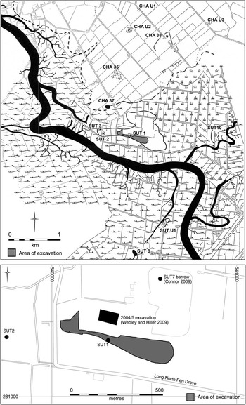
Located 5km to the south of Chatteris (TL 4045 8132), the North Fen ‘island’ stands slightly elevated above the surrounding low-lying former fen at just 0–1.5 m OD (Fig. 2). First identified by the work of the Fenland Project (Hall Reference Hall1996), the site has, for some time, been known as an area of significant prehistoric activity. Field survey in the mid-1980s recorded scatters of Neolithic pottery and worked flint (ibid., SUT 1 & 2) along with five Early Bronze Age round barrows (ibid., SUT 3–7), while to the north extensive prehistoric activity – including further Neolithic surface scatters – is also recorded on the fringes of Chatteris island (Hall Reference Hall1992). Subsequently, numerous phases of archaeological evaluation and excavation have taken place at North Fen in advance of gravel extraction/irrigation reservoir construction. Significant sites excavated include the Fenland Project’s SUT 7 round barrow (Conner Reference Connor2009) and a series of Neolithic/Early Bronze Age buried soil horizons and Early Bronze Age watering holes just to the north of the current excavation area (Webley & Hiller Reference Webley and Hiller2009).
The North Fen excavation area and previously identified/excavated sites in the locale (Fenland Project sites are shown with the original mapping (after Hall Reference Hall1992; Reference Hall1996) and with the prefix SUT [Sutton parish] or CHA [Chatteris parish])

The excavation area itself (4.47 ha) occupied a sand ridge along the southern fringe of the North Fen island effectively forming a raised terrace overlooking the former course of the River Great Ouse to the south. The ridge clearly equates to the ‘tongue of sandy soil’ noted by Hall (Reference Hall1996) during the Fenland Project, on which both of the recorded Neolithic sites on North Fen were located. To the south and west, beyond the river, an expanse of low-lying fen extends as far as the south-western fen-edge at Earith, while to the north, ‘mainland’ Chatteris extends to within a few hundred metres of the North Fen island.
Although the current investigations did not include a substantial palaeoenvironmental component, the site does benefit from work done in the near vicinity as part of the Fenland Project (Waller Reference Waller1994). For most of the Neolithic the site appears likely to have been relatively dry and represented more of a riverside-terrace, rather than ‘island’, locale. It was not until the later Neolithic that a major marine incursion, followed by numerous freshwater flooding episodes during later prehistory, led to the development of extensive fen carr, sedge fen and reed swamp. At some point during this period the North Fen island appears to have effectively been submerged and abandoned until drainage during the post-medieval period once again made the land suitable for cultivation.
THE EXCAVATION
The excavation revealed evidence of activity dating from the Late Mesolithic through to the Early Bronze Age comprising artefact scatters within surviving buried soil horizons, as well as features including pits, ring-ditches/gullies and watering holes. The site’s Early Bronze Age–Beaker- and Collared Urn-associated – evidence will be published separately, together with the site’s later Neolithic flint scatter (Tabor Reference Tabor2015), allowing this paper to concentrate on the Early Neolithic evidence alone: two discrete artefact scatters (Scatters A & B) and a total of 48 pits. As a result of the ‘abandonment’ of the site, probably at some point during the Early–Middle Bronze Age, the ‘palimpsest-effect’ that so often confuses the overall picture at many sites, was much reduced. Accordingly, there was a remarkable clarity to the evidence allowing the identification of clear zones of activity, not just in terms of pit clusters but also artefact scatters.
As with many fenland sites, the protection that the overlying peat and alluvial deposits afford resulted in excellent preservation of buried soils and surface deposits/artefact scatters compared to the majority of ploughed sites. This additional dimension to the archaeological evidence highlights the degree to which most site plans represent a heavily truncated image and most finds assemblages are far from ‘complete’ (see also Evans et al. Reference Evans, Tabor and Vander Linden2014 on the archaeology of Over/Barleycroft). It is sobering indeed that, following the removal by machine of the buried soil at the site of Scatter A, no archaeological features were revealed beneath and that a finds assemblage amounting to only ten small abraded sherds of pottery and three flints was recovered from a single tree-throw: clearly there would have been minimal trace of Neolithic activity in this area had it been plough truncated. Of course, this is not to suggest that the remains at North Fen represent anything approaching a complete picture, perhaps most frustratingly the buried soils around the main pit clusters were truncated resulting in the loss of any evidence of potential ‘surface’ activity directly associated; in many ways, the site merely hints at the quantity of evidence that has undoubtedly been lost.
Artefact scatters and the buried soil
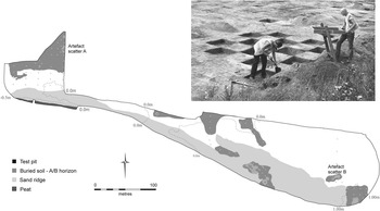
The buried soil, which survived to varying degrees across the site (Fig. 3), comprised a poorly developed brown earth; a woodland soil, subjected to clearance and disturbance before submergence by peat and/or alluvial deposits – probably from the Early–Middle Bronze Age onwards – commonly recorded at prehistoric fenland sites (see French in Tabor Reference Tabor2015). Sampling followed a methodology developed during the Haddenham Project and the Barleycroft/Over investigations (Evans & Hodder Reference Evans and Hodder2006; Evans et al. Reference Evans, Tabor and Vander Linden2014) utilising metre test pits. Preliminary sampling, comprising a series of north–south transects of test pits situated at 20 m intervals, indicated that over the majority of the site artefact densities were low. However, where more complete buried soil profiles survived (A & upper B horizons), artefact densities were found to be much higher. In these areas additional test pits were laid out on a 10 m grid in order to ‘home in’ on artefact scatters, which were then more intensively sampled using a checkerboard pattern of alternate test pits; 100% sampling of the buried soil was also undertaken at the core of scatters where finds densities were exceptionally high. The soils from all test pits were sieved using a 5 mm mesh to maximise artefact recovery.
Artefact scatters and buried soil horizons

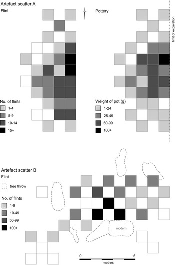
In total, five artefacts scatters were recorded of which two were Early Neolithic (Scatters A & B; Fig. 4). Although scatters were identified through buried soil test pitting, the location of Scatter B (see below) particularly was marked by significant amounts of surface material. Comprising pottery, flint, burnt flint/stone, and small amounts of animal bone, the finds assemblages from the scatters are detailed in Table 1.
Artefact scatter distribution plots

Early Neolithic Artefact Scatter Assemblage Breakdown

Although the scatters clearly contained some residual or ‘intrusive’ material, each was remarkably well-defined both chronologically and spatially. It is worth noting that although they were both located only in areas where more complete buried soil profiles survived, they were still distinct scatters with clear extents (ie, not merely surviving pockets of a much larger ‘spread’ of finds within the buried soil). Furthermore, the composition of each scatter in terms of quantities/proportions and types of finds, was distinct:
SCATTER A Extending over 43 m2, although given its location at the edge of the excavated area, its full extent could not be determined. Finds densities ranged from 1 to 56 finds per metre square (ave. 19). Significant quantities of Early Neolithic Mildenhall style pottery occurred alongside a flint assemblage, which appears to primarily reflect tool-use and limited flintworking. Animal bone was limited to a single cow tooth.
SCATTER B Recorded over 46 m2, this had finds densities ranging from 0 to 137 finds per metre square (ave. 28). Its assemblage overwhelmingly comprised flint, together with small amounts of burnt flint/stone and nine fragments of unidentifiable calcined bone; pottery was completely absent. In contrast to Scatter A, the worked flint assemblage is dominated by working waste – with only limited evidence of tool-use.
The character and composition of the two artefact scatters indicates that while both appear to be broadly contemporary they represent very different activities. Scatter A, with its pottery component and higher proportion of flint tools, is more suggestive of occupation/settlement, and in many ways is comparable to the site’s pit cluster assemblages (see below). Furthermore, whilst the pottery sherd count particularly is significantly less than that from the pit site, given that Scatter A is likely to have suffered weathering and fragmentation for almost 2000 years before it was ‘sealed’ by fen deposits (as well as the fact that the site was only partially exposed), it must evince a much more substantial occupation than at first appears. In contrast, Scatter B seems to represent a flintworking site separated from a settlement context per se.
No archaeological features were found to be associated with either scatter, although tree-throws were recorded at both; one, at Scatter A, yielded a small assemblage of pottery and flint (ten abraded pot sherds and three flints). Unfortunately, we cannot be certain that no archaeological features were associated with Scatter A, given that it extended beyond the limit of excavation; nevertheless, from the available evidence, it does seem to attest to domestic occupation without pits or other cut features.
Early Neolithic pits
Forty-eight Early Neolithic pits, the majority occurring in six clusters (Clusters 1, 3–7), were recorded on the sand ridge in the south of the excavation area (Fig. 5). Of these, 36 contained diagnostic Mildenhall style pottery; a further 12 are believed to be broadly contemporary either because they formed part of a well-dated cluster or, in the case of the seven pits in Cluster 7, as a result of their proximity and similarity to Clusters 3–6. All pits that contained finds or formed part of a clearly defined cluster were 100% excavated with their fills sieved (5 mm mesh).
The Early Neolithic pit site

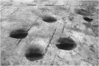
The form and character of the individual pits was typical of contemporary pit sites in the region (Fig. 6). Comparatively small in size (0.3–1.13 m in diameter by 0.03–0.34 m in depth), they were sub-circular or sub-oval with bowl-shaped profiles. Some variation in the character of the individual pit fills was noted and some contained thin primary fills, suggesting they were potentially ‘open’ for a short time at least. Generally speaking, however, as at sites such as Kilverstone (Garrow et al. Reference Garrow, Beadsmoore and Knight2005), the pits appear to have been backfilled relatively soon after they were dug.
The main concentration of pits within Cluster 3

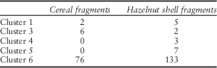
Pits were grouped into clusters based on spatial relationships (i.e. clustering) and preliminary pottery spot dates. Of the pits having finds, the size of pottery and flint assemblages varied (Table 2). The majority of the pottery belonged to the plain-bowl Mildenhall style tradition, although some sherds were decorated; the flint largely comprised working waste alongside utilised and retouched flakes and blades, together with a small number of formal tools. Six pits had small quantities of fragmented and calcined animal bone, amongst which only four fragments – a sheep/goat metatarsus fragment and three loose pig teeth – were identifiable to species (Rajkovača in Tabor Reference Tabor2011). Just over half of the features contained small amounts of burnt flint/stone, whilst worked stone was limited to one pit (F.66) that yielded a spherical cobble utilised as a stone rubber – probably in conjuction with a saddlequern – and subsequently as a hammerstone (Timberlake in Tabor Reference Tabor2011). Finally, of the 13 pits for which environmental samples were processed, charred cereal fragments (barley and wheat) were forthcoming from seven and eight contained charred hazelnut shell (Fryer in Tabor Reference Tabor2011). Quantities of both were on the whole very low, although as shown in Table 3 relatively high numbers were recovered from pits F.66 and F.74 in Cluster 6.
Pit Cluster Assemblage Breakdown

Charred Cereal and Hazelnut Shell Quantities by Pit Cluster

As established at Kilverstone and other pit sites (Garrow et al. Reference Garrow, Beadsmoore and Knight2005), the finds assemblages were for the most part fragmented and piecemeal, indicating that they must derive from some kind of surface deposit or midden heap. Frustratingly, although relatively high numbers of flint surface finds occurred around Clusters 5 and 6, plough truncation of the buried soil around the pit clusters generally meant that any evidence of these surface deposits did not survive and the test pit finds densities in these areas were correspondingly low. As shown in Table 2, the pit clusters varied markedly, both in terms of size and in the richness and character of their assemblages. There was, however, also significant variation in the finds assemblages from individual pits within clusters that requires closer scrutiny:
CLUSTER 1 (3 PITS): The small assemblage of pottery and flint recovered from this cluster was, with the exception of one flint, entirely derived from one pit.
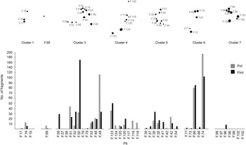
CLUSTER 3 (11 PITS): Of this cluster’s pits, three contained no finds while the large majority of the cluster’s finds assemblage – 207 sherds of pottery (92% of the assemblage) and 144 flints (79%) – derived from just four pits; of these, a single pit (F.49) contained an impressive 111 sherds (1036 g) equating to 49% of the cluster’s pottery assemblage. The remaining four pits had comparatively low quantities of finds (0–11 sherds; 0–29 flints).
CLUSTER 4 (7 PITS): Quantities of finds per pit in this cluster were generally low, with five of the seven features containing 1–16 sherds of pottery and 0–5 flints. One had a slightly larger finds assemblage (36 sherds of pottery and 32 flints); another contained no finds.
CLUSTER 5 (9 PITS): Quantities of finds per pit were low (0–21 sherds of pottery; 0–23 flints), although all of the pits had some pottery and/or flint.
CLUSTER 6 (5 PITS): Of this cluster’s pits, three produced only very small quantities of finds (a total of one pottery sherd and four flints between them), with almost all of the cluster’s substantial finds assemblage deriving from two pits. Pit F.66 had 80 sherds (498 g) of pottery and 67 (134 g) flints, while the site’s largest pit assemblage by far came from Pit F.74: 196 sherds (2038 g) and 77 (151 g) flints.
CLUSTER 7 (7 PITS): One pit in this cluster contained seven worked flints of which six were small chips; no other finds were recovered.
The clusters can, it seems, be divided into three broad types; those with very few finds (Clusters 1 & 7); those with a moderate, but still comparatively low, number of finds (Clusters 4 & 5); and those with large numbers (Clusters 3 & 6). Furthermore, of the latter, the vast majority of finds derived from just four pits (F.49. F.50, F.66, & F.74), which contained significant pottery and flint assemblages, as well as the only instances of refitting pottery sherds and flint (either within or between individual pits).
This takes on added significance when it is considered that refitting pottery sherds and flints occurring in different pits were otherwise absent, as were any other clear patterns of deposition within clusters (as seen at Kilverstone, e.g. Garrow et al. Reference Garrow, Beadsmoore and Knight2005).
In addition to the pit clusters, a further six pits that had minor amounts of Early Neolithic pottery can also tentatively be dated to this period, while many of the 40 undated pits – especially those close to the main pit site – may also be contemporary. It is, however, difficult to comment further on these isolated pits given that they have no clear association with the Neolithic activity and that the limited number of artefacts recovered from them potentially represent no more than the generic residues of past occupation within the surrounding soils. Pit F.68 is, however, worthy of mention in that, located just to the west of Cluster 3, it contained six sherds of Mildenhall style pottery and was potentially an ‘outlier’ of the main pit site.
THE WORKED FLINT AND POTTERY ASSEMBLAGES
Worked Flint
(Lawrence Billington)
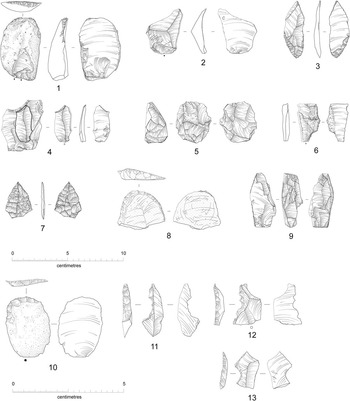
A total of 1439 worked flints and 144 g of unworked burnt flint were recovered from Early Neolithic contexts, with the sieving of these deposits resulting in the recovery of relatively large numbers of small chips and flake fragments. The assemblage – which is fully quantified and described in detail in supplementary Appendix S1 – is generally in very good condition. It comprises largely fine grained high quality flint, which varies in colour and in the character of cortical surfaces; most was probably collected from a local gravel source although probable chalk flint is also present. In terms of flintworking technology, the reduction strategy can be broadly categorised as blade/narrow flake-based, and evidence for all stages of core reduction, including decortication flakes, waste flakes, and discarded cores (eg, Fig. 7, Nos 5 & 9), are present. The retouched component of the assemblage is dominated by a typical range of Neolithic tools: serrated blades and flakes (eg, Fig. 7, Nos 2, 4 & 6) are the most numerous type, but also present are eight scrapers (eg, Fig. 7, Nos 1, 8 & 10) and four leaf shaped arrowheads (one complete and three broken: eg, Fig. 7, Nos 3 & 7).
Early Neolithic flint

At a general level, the flintwork is typical of assemblages from other Early Neolithic sites in the local area and in East Anglia, especially in terms of flintworking technology and the range of retouched tools recovered (eg, Beadsmoore Reference Beadsmoore2006; Bishop Reference Bishop2011). Notwithstanding these general characteristics, the recovery of discrete assemblages from cut features and two buried soil scatters offers a useful opportunity to examine the differences and variability in assemblage composition and character between different depositional contexts. This variability operates at a diverse series of scales, including within and between the pit site and artefact scatters, as well as in comparison to other Early Neolithic assemblages recovered from the wider region.
There are considerable and significant differences in the size, composition, raw materials and condition of the flintwork recovered from the individual pit clusters. Clusters 1 and 7 are notable for producing very small assemblages of worked flint of seven pieces each, whilst Clusters 3 and 6 contained large assemblages of 303 and 194 flints respectively. Within these ‘richer’ clusters the majority of the flintwork derived from one or two features: pit F.50 in Cluster 3 and pits F.66 and F.74 in Cluster 6. These larger assemblages are not, however, necessarily comparable in terms of composition and character. Pit F.50 had no retouched tools and a large number of chips and waste flakes under 20 mm in size. No refitting pieces were identified and it seems likely that this material was drawn from a larger assemblage of knapping waste. In contrast, the assemblage from pits F.66 and F.74 contained retouched tools, including two leaf shaped arrowheads. Pit F.66 was also the only feature in which refitting pieces and pieces probably struck from the same nodule were identified; the refits comprised two pairs of co-joining removals including a serrated flake that refit to a larger flake.
The distinctive characteristics of the assemblages from individual clusters and pits hint at variety and complexity in the pre-depositional histories of the flintwork. Thus whilst the majority of the pit assemblages appear to have derived from contexts in which both tool-use and flintworking are represented, the assemblage from pit F.50 (Cluster 3) seems to have been drawn from a larger assemblage dominated by knapping waste. Similarly, in the assemblage from Cluster 6, that includes refitting pieces, an emphasis on secondary sources of raw material and high levels of burning might indicate greater immediacy in the deposition of material compared with many of the other clusters, which rather appear to have drawn on larger and more disparate pre-pit assemblages.
The flint assemblages from Scatters A and B provide further evidence for differences in the temporality and character of occupation. Whilst knapping waste, in the form of chips and small flakes, is well represented in the pit clusters, the assemblage from Scatter A has far fewer of these pieces and has a complementary higher proportion of retouched and utilised pieces. This strongly suggests that the immediate area of Scatter A saw little or no in situ flintworking, with the assemblage demonstrating a greater emphasis on other tasks involving the use of flint tools. These differences in composition also imply that Scatter A cannot be seen straightforwardly as representing a ‘pre-pit context’ from which material was drawn for deposition within pits (Garrow et al. Reference Garrow, Beadsmoore and Knight2005), and also refutes any notion, at least in this case, that tools were preferentially and deliberately deposited within features.
In the absence of strictly chronologically diagnostic pieces and accompanying pottery the Scatter B assemblage is less securely dated than the other Neolithic contexts. The technological traits of its assemblage are, however, strongly suggestive of an earlier Neolithic date and are certainly distinct from Mesolithic and later Neolithic assemblages locally (including assemblages recovered from North Fen: see Tabor Reference Tabor2015). The assemblage is notably coherent in terms of raw material when compared with most of the site’s other assemblages, with several flakes, chunks of irregular waste and a nodule all almost certainly deriving from the same nodules of raw material. The scatter probably represents a discrete episode of activity, dominated by evidence for flintworking and perhaps some rather specialised tool-use or manufacture, as indicated by the presence of several unusual abruptly retouched tools and lack of other tools, notably serrated pieces. Whilst it contains material from all stages of core reduction, including chips, waste flakes and discarded cores, the composition of the assemblage suggests that certain parts of the reduction sequence are far better represented than others. Decortication flakes, reflecting the earlier stages of core reduction, are well represented and a high proportion of chips and small flakes and fragments provide good evidence for in situ flintworking, as do its numerous discarded cores. In contrast there is a relative paucity of the finer tertiary removals that would have been produced during the main phases of core reduction and it seems that many of these pieces may have been removed from the scatter.
Whilst much of the variation between flintwork assemblages from individual contexts of deposition is subtle and difficult to interpret, it clearly indicates that there were significant differences in the character and tempo of the activities represented by the pit clusters and artefact scatters. Notwithstanding the differences between individual clusters and features, the assemblage from the pits provides good evidence for a wide variety of tasks, including flintworking and the use of flint tools, which might equate with a range of domestic- or settlement-type activities. Raw materials are also varied, with the pits containing a higher proportion of non-local, probable chalk flint (28% of cortical pieces) than Scatters A and B (16% & 1% of cortical pieces respectively). In contrast, the assemblages from Scatters A and B show a greater degree of specialisation – probably relating to relatively short-lived episodes of activity with a greater emphasis on certain tasks. In the case of Scatter A, this activity appears to have been strongly orientated towards the use of flint tools with a proportionate lack of evidence for flintworking. This implies that whilst the relatively wide range of tools and presence of pottery in Scatter A indicates activity that could be broadly defined as settlement-related, this might have been of an altogether different duration and character than that seen in the pit clusters. Scatter B, conversely, is characterised by evidence for the intensive working of flint, dominated by secondary, potentially local raw materials. Many of the usable products of this working are absent and tool-use appears to have been restricted to certain rather unusual forms – including abruptly retouched pieces (eg, Fig. 7, Nos 11–13) – strongly suggesting a discrete and specialised episode of task-based activity.
Our understanding of Early Neolithic flintworking in East Anglia is largely based on assemblages recovered from pit sites such as Hurst Fen (Clark et al. Reference Clark, Higgs and Longworth1960), Broome Heath (Wainwright Reference Wainwright1972), Spong Hill (Healy Reference Healy1988), and Kilverstone (Beadsmoore Reference Beadsmoore2006); from artefact-rich tree-throw and midden deposits such as those at Laurel Farm (Bishop Reference Bishop2011), Barleycroft Farm, Hinxton (Pollard Reference Pollard1996; Reference Evans and Knight1997), and the John Innes Centre (Robins Reference Robins2004); as well as assemblages from causewayed enclosures such as Etton (Middleton 1998) and Great Wilbraham (Edmonds Reference Edmonds2006). Across East Anglia, a broad distinction can be made between very large assemblages with relatively low numbers of retouched tools (eg, Kilverstone, the John Innes Centre, and Broome Heath) and smaller assemblages in which tools are much better represented (eg, Barleycroft and Hinxton). It is perhaps notable that many of the larger assemblages are from the eastern part of the region where flint resources are far richer, both from primary and secondary sources, perhaps suggesting the profligate working of flint in these areas goes hand-in-hand with a lower proportion of retouched pieces. The pit cluster assemblage from North Fen is intriguing in this respect as, despite its relatively small size, it has a low frequency of retouched tools (2.6%); the proportion of retouched tools in Scatter A (10.2%) being closely comparable to other Cambridgeshire sites at Hinxton and Barleycroft.
There is also considerable variability in the relative proportions of tool types across the sites. The assemblage from Broome Heath, for example, is characterised by very low numbers of serrated pieces and has a correspondingly large number of scrapers. This contrasts with other sites, including Laurel Farm and Hinxton, as well as the pit clusters and Scatter A at North Fen, where serrated pieces are much better represented and scrapers are rarer. Although caution is required with making straightforward equations between tool form and economic practices, it does seem likely that variability in tool types relates to differences in the activities being undertaken at these sites: scrapers perhaps relating to hide processing and serrates used to collect cereals or wild plant resources (Donahue Reference Donahue2002; Donahue & Evans Reference Donahue and Evans2009).
Early Neolithic pottery
(Mark Knight)
The Early Neolithic assemblage comprised 1215 sherds of Mildenhall pottery (5980 g; MSW 4.9 g). While by no means the largest assemblage of Mildenhall pottery from East Anglia, its point of interest rests first and foremost in its contextual detail and, in particular, the fact that a significant part derived from the old land surface/buried soil.
The bulk of the material came from pits (76.0% by weight; 684 sherds/4546 g), although test pitting of the buried soil also produced a sizable quantity (22.8%; 403 sherds/1046 g); a small collection of surface finds made up the remainder (1.1%; 7 sherds/68 g). Potsherds recovered from features were usually larger and less abraded or weathered than those from the buried soil or its surface. While the condition of the assemblage was generally good, the majority (89.5%) of the fragments measured less than 40 mm across.
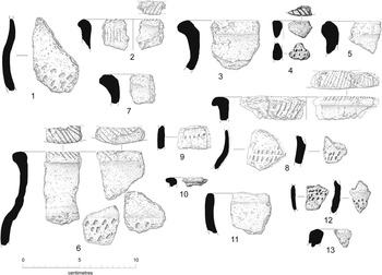
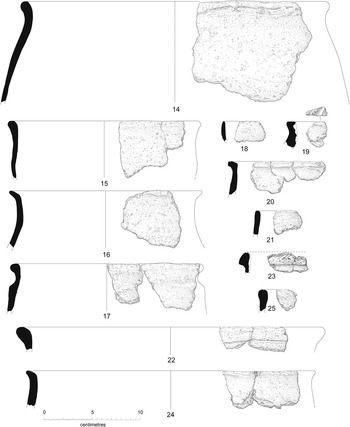
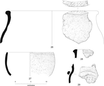
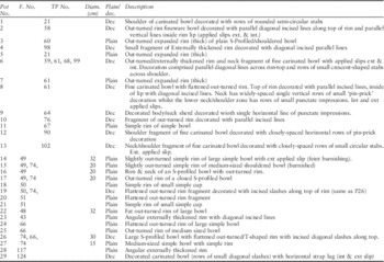
Feature sherds comprised 59 rims and 26 decorated pieces. A three-fold fabric series was established and included hard and medium hard types with crushed flint and/or crushed shell inclusions. The majority of the range of forms present corresponds with the Hurst Fen-type series (Clark et al. Reference Clark, Higgs and Longworth1960), and includes simple/straight-sided, shouldered and ‘S’-profiled bowls as well as simple cups. The group can also be separated into finewares and coarsewares/heavier storage vessels based primarily on the presence/absence of decoration, applied slips, burnished surfaces and fine or crude modelling of features such as rims, necks and shoulders. Plain sherds greatly outnumbered decorated sherds, although the propensity of plain over decorated was very much context specific. Further description of the pottery forms, decoration and their context, as well as the fabric series, is presented in supplementary Appendix S2. A selection of sherds is illustrated in Figs 8–10 and described in Table 4.
Early Neolithic pottery from Scatter A (P1–13)

Early Neolithic pottery from the pit site (P14–25)

Early Neolithic pottery from the pit site (P26–29)
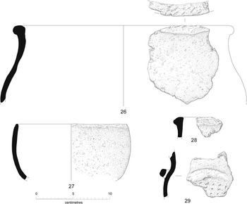

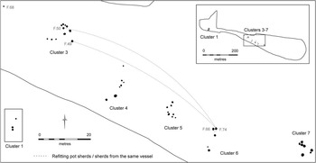
As detailed above, two principal concentrations of pottery were demonstrated: the main pit site (Pit Clusters 3–6) and buried soil Scatter A. The bulk of the pit-derived material came from features situated at either end of the pit site (Cluster 3: 25.7% by weight; Cluster 6: 42.4%). Exhaustive refitting analysis proved pits F.49 and F.50 in Cluster 3 to be materially linked to pit F.74 of Cluster 6. Conjoining out-turned rim sherds from a medium-sized shouldered bowl (P15) were found in pits F.49 and F.74 (located 64.9 m apart), whilst matching but not joining out-turned rims from a closed ‘S’-profiled bowl (P17) occurred within the same pairing. Similarly, a flattened out-turned rim with incised slashes along its top (P19) from pit F.50 bore a striking resemblance to rim sherds (P26) within pit F.74. As well as refits and sherds belonging to the same vessel, there was also a consistency in terms of common forms and fabrics, with the majority of the assemblage comprising ‘coarse’ plain vessels. Combined, the ceramic connections articulated an otherwise obscure relationship between spatially distinct features; the connections effectively aggregating the individual pit clusters into one cohesive agglomeration.
Refits and sherds of the same vessel were also achieved between different test pit squares of buried soil Scatter A. Here fragments of a fine carinated bowl decorated with parallel diagonal lines and rows of small crescent-shaped dots (P6) were found in test pits up to 4 m apart. At the same time, there was also a consistency in terms of common forms and fabric – with ‘fine’ decorated vessels most prevalent – giving the assemblage an internal coherency that made it distinct from the pit site assemblage. Consequently, differences in form, fabric and a total absence of refits between the buried soil scatter and the pit site added to the impression of divergent collections. The material deposited within the pits was also a little less fragmentary than that present within Scatter A (Appendix S2, Fig. S4). It is possible that this characteristic was indicative of dissimilar taphonomic histories, with the pit material being less exposed to post-depositional processes such as cultivation.
As a regional variant of the southern Neolithic decorated bowl tradition, Mildenhall pottery has been most frequently found either in the basal fills of segmented ditches of causewayed enclosures (Bamford Reference Bamford1985; Pryor Reference Pryor1998; Evans & Hodder Reference Evans and Hodder2006; Evans et al. Reference Evans and Hodder2006) or within the backfill of large and small conglomerations of small diameter pits (Clark et al. Reference Clark, Higgs and Longworth1960; Wainwright Reference Wainwright1972; Healy Reference Healy1988; Evans & Knight 1997; Garrow et al. Reference Garrow, Lucy and Gibson2006; Appendix S2, Fig. S5). Less widespread contexts include the facades and quarry ditches of long barrows (Evans & Hodder Reference Evans and Hodder2006) and the circuits of early 4th millennium bc ring-ditches (Clarke & Lavender Reference Clarke and Lavender2008; Patten & Lucy Reference Patten and Lucyforthcoming). Significant concentrations from surface/buried soil contexts are by comparison rare; although the type-site Hurst Fen recorded a ‘cultural layer’ (Clark et al. Reference Clark, Higgs and Longworth1960, 203) and there was a ‘fossil soil’ at Broome Heath (Wainwright Reference Wainwright1972, 3), little actual analysis has focused on the character and depositional history of buried land surface or ‘extra-feature’ assemblages.
The contextual detail available at North Fen is exceptional in that it enables us to explore a sizable non-cut feature Mildenhall assemblage. In light of current research this is important because feature-based assemblages, such as those typically found at causewayed enclosures and pit sites, appear to have undergone a protracted depositional sequence or post-breakage history ‘above ground’ prior to deposition (Garrow et al. Reference Garrow, Beadsmoore and Knight2005; Beadsmoore et al. Reference Beadsmoore, Garrow and Knight2010). This gap or deferment between the breaking of vessels and their ultimate deposition presupposes an intermediate context, such as a heap or midden, which accruing over time would have incorporated broken pots, along with other ‘redundant’ material (eg, worked flint, burnt flint, burnt stone, animal bone, charred hazelnut shells, and burnt fuel). In terms of ceramic studies, evidence for its existence is contingent upon the co-presence of fresh, weathered and burnt sherds within the final ‘burial’ context, which when refitted demonstrates different surface effects that had to have happened after the pots had been broken but prior to deposition. As such, the presence of an intermediate above-ground context for broken Mildenhall pottery had been inferred but never formally identified or investigated.
Significantly, the North Fen material can be subdivided into two contextually discrete assemblages: one feature-related and the other buried soil-based. In addition to having different contexts, the two assemblages also diverged compositionally: the former comprising for the most part large pieces of ‘coarse’ plain vessels made with hard (flint) and soft (shell) fabrics, whilst the latter consisted chiefly of small fragments belonging to predominantly ‘fine’ decorated vessels made exclusively with hard fabrics. The refined appearance of the buried soil assemblage was further accentuated by other attributes such as carefully modelled rims, internally and externally applied slips, burnished surfaces, and defined zones of delicately accomplished decoration. Conversely, the feature-based assemblage was characterised by its comparatively crudely fashioned rims, alongside a general absence of equivalent surface treatments. Similarities did exist, including a degree of overlap in fabric types, vessel forms, rim types, vessel sizes, and incompleteness, but overall, the dissimilarities between the two groups were sufficient to indicate the presence of two different, yet complementary ‘Mildenhall’ assemblages: one largely decorated, the other ostensibly plain. As such the Scatter A pottery represents a separate assemblage from the pottery found within the pits and cannot be seen as the original ‘source’ for the interred material. In all probability, the two assemblages embody the vestiges of distinct episodes of occupation disconnected qualitatively, temporally and spatially.
Importantly, the overlap or broadly complementary character of the two assemblages precludes drawing direct parallels with the evidence from Barleycroft Paddocks situated 10 km further up the Ouse Valley, where a substantial assemblage of plain Early Neolithic pottery derived from two tree-throw features was likewise shown to be different from an assemblage of Mildenhall wares recovered from an adjacent cluster of pits (Evans et al. Reference Evans, Pollard and Knight1999). Pollard was able to differentiate a plain component on the basis of typological differences, including the presence of light flared rims and generally more open forms, all of which contrasted with the heavier, more elaborate rims and neutral/closed forms present within the pit-related Mildenhall assemblage. As a consequence, the plain assemblage from the tree-throw at Barleycroft was interpreted as being part of an earlier ‘Grimston’ (Herne Reference Herne1988) or Classic Carinated Bowl tradition (Cleal Reference Cleal2004) and for that reason pre-Mildenhall. Single radiocarbon dates taken from one of the tree-throws and a pit were utilised to illustrate a chronological division (Evans et al. Reference Evans, Pollard and Knight1999), although a recent re-evaluation of Early Neolithic radiocarbon dates from eastern England has proven the Barleycroft assays to be statistically consistent (Healy et al. Reference Healy, Bayliss, Whittle, Pryor, French, Allen, Evans, Edmonds, Meadows and Hey2011, 288).
Genuine parallels for spatially discrete undecorated ‘Mildenhall’ or related plain bowl assemblages include sites such as Kilverstone (Knight Reference Knight2006) and Broome Heath, (Wainwright Reference Wainwright1972), both located in Norfolk. The Kilverstone Area E site (1767 sherds) included some pit clusters with assemblages made up entirely of fragments of plain vessels alongside a larger number of pit clusters containing amalgams of both plain and decorated wares (although the propensity was invariably plain – 78% of total number of vessels – over decorated: 22%). Exhaustive refitting analysis showed that each cluster was independent from the next and that each held its own exclusive Mildenhall assemblage. The Broome Heath assemblage (4648 sherds) was different in that it was made up almost entirely of plain forms (Wainwright Reference Wainwright1972, 73). The near absence of adornment encouraged the excavator to locate the pottery within the earlier plain bowl tradition although a subsequent reappraisal of the Broome Heath material accurately identified it as an undifferentiated Plain Bowl assemblage characteristically equivalent to the undecorated component of a Mildenhall assemblage (Herne Reference Herne1988, 14–15; see also Healy et al. Reference Healy, Bayliss, Whittle, Pryor, French, Allen, Evans, Edmonds, Meadows and Hey2011, 338).
The different propensities of decorated or plain forms at ‘Mildenhall sites’ introduce a different complexity to depositional practice, especially in relation to structured or selective deposition and the notion that decorated or particularly fine sherds may have been specially selected for deposition within pits. More often than not, it was the nondescript or characterless sherds that were deposited in pits, whereas the special or ‘stand out’ fragments were apparently haphazardly disregarded. In reality, the contextual detail presented here suggests that the presence (or absence) of embellishment or ornamentation was never the primary criteria for depositing broken fragments of pottery into pits.
In summary, two compositionally divergent Mildenhall assemblages: one predominantly ‘coarse’ and plain, the other ostensibly ‘fine’ and decorated can be identified at North Fen; the two assemblages were also contextually and spatially independent, with the former being associated with the pit site, and the latter with Scatter A. Distinct depositional histories were made clear by marked differences in comparative sherd size and overall condition with the pits producing generally much larger and fresher pieces than the adjacent buried soil. Despite the dissimilarities, the pottery from both contexts can be accommodated within the same ceramic tradition and, as such, the two groups represent ‘complementary’ assemblages made manifest by different depositional circumstances.
RADIOCARBON DATING
(Frances Healy)
Six samples from Early Neolithic pits were submitted for radiocarbon dating. Of these, an articulated piglet skeleton was found to be a very recent intrusion (although the pit in Cluster 4, F.123, from which it apparently came, otherwise produced a coherent Early Neolithic finds assemblage). The remaining five samples comprised four of charred hazelnut shell and one of carbonised residue from the interior of a pot. They were thus all short-lived materials probably contemporary with their contexts (Table 5). Only the pit clusters could be dated, material associated with the artefact scatters being unsuitable due to its context within what was effectively an Early Bronze Age buried soil.
Radiocarbon Measurements for Selected Early Neolithic Pits

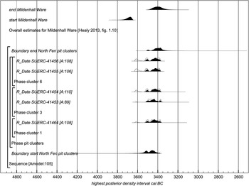
Calibrated date ranges (at 95% confidence) are calculated by the maximum intercept method (Stuiver & Reimer 1986) and rounded outwards to the nearest 10 years. The highest posterior density intervals (at 95% probability) are derived from the model shown in Figure 11. Calibrations and analysis were undertaken using the program OxCal v4.2 (https://c14.arch.ox. ac.uk/oxcal/; Bronk Ramsey 2001; 2009) and the INTCAL13 dataset (Reimer et al. 2013)
With even this small number of dates, precision can be improved by Bayesian analysis, which essentially consists in combining the dates with other relevant archaeological information. In the absence of any stratigraphic relations between the samples, this comes down to modelling the results as part of a single episode of activity (cf, Garrow et al. Reference Garrow, Meadows, Evans and Tabor2014, 14–15). The assumption of a single phase serves to constrain the scatter inherent in radiocarbon ages, which would otherwise make episodes of activity appear to start earlier, continue longer, and end later than they actually did (Steier & Rom Reference Steier and Rom2000). Constraint is particularly desirable here because wiggles in the calibration curve between c. 3650 and 3350 cal bc mean that simple calibrated dates can have extended, often polymodal, distributions. In the case of the North Fen pits, a single phase is justified by the shared ceramic style, including conjoins, of Clusters 3 and 6, by the shared characteristics of their flint industry, and by the fact that a χ2 test shows all five dates to be statistically consistent (T'=2.5; T'(5%)=9.5; ν=4), including SUERC-41464 from Cluster 1, spatially removed from the rest and exceptionally poor in artefacts.
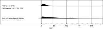
The model shown in Figure 11 provides an estimated start date of 3605–3375 cal bc (95% probability), probably of 3535–3495 cal bc (22% probability) or of 3490–3420 cal bc (46% probability; Fig. 11: start North Fen pit clusters), and an estimated end date of 3515–3305 cal bc (95% probability), probably of 3440–3355 cal bc (68% probability; Fig. 12: end North Fen pit clusters). These estimates lie in the later part of an overall duration for Mildenhall Ware estimated on the basis of dates available in 2013 (Healy Reference Healy2013, fig. 1.10). Stylistic distinctions between the pottery from the buried soil and from the pit clusters could be compatible with different dates. In the estimated duration for the North Fen pits of 1–135 years (95% probability), probably 1–65 years (68% probability; Fig. 12: use North Fen pit clusters) most of the probability lies in the short part of the distribution. These results suggest that the pits were filled with material generated during a fairly brief episode, perhaps analogous to the 1–35 years (95% probability), probably 1–20 years (68% probability) estimated for pits inside the Neolithic causewayed enclosure at St Osyth, Essex (Bayliss et al. Reference Bayliss, Allen, Healy, Whittle, Germany, Griffiths, Hamilton, Higham, Meadows, Shand, Stevens and Wysocki2011, Fig. 7.7: use St Osyth). The St Osyth estimate is more precise because it is based on more dates.
Probability distributions of radiocarbon dates for samples from the North Fen pit clusters. Each distribution represents the relative probability that an event occurred at a particular time. Two distributions are plotted for each date, one in outline which is the result produced by the scientific evidence alone, and a solid one which is based on the chronological model. The model is defined by the square brackets down the left-hand side of the diagram and by with the OxCal keywords. The results are compared with estimated start and end dates for the overall currency of Mildenhall Ware based on information available up to 2013 (Healy Reference Healy2013, fig. 1.10)

An estimated use-life for the North Fen pit clusters, derived from the model shown in Fig. 11, compared with that for pits inside the causewayed enclosure at St Osyth, Essex (Bayliss et al. Reference Bayliss, Allen, Healy, Whittle, Germany, Griffiths, Hamilton, Higham, Meadows, Shand, Stevens and Wysocki2011, fig. 7.7)

DISCUSSION
Site signatures
Perhaps the most striking aspect of the Early Neolithic activity at North Fen is the fact that each individual site, whether it be artefact scatter or pit cluster, appears distinct and had its own character or ‘signature’. It can be argued that each represents activity, which is separated spatially, temporally (in part at least) and in terms of the nature of the tasks and activities reflected in the material assemblages. While North Fen is in many ways a landscape palimpsest in a broader sense, each individual site appears ‘uncluttered’ by the accumulated evidence of subsequent (or indeed prior) activity and as a result has a clarity, which is absent from many fenland sites/artefact scatters where the potential time depth present makes characterising the scale and duration of activity/occupation problematic (see Edmonds et al. Reference Edmonds, Evans and Gibson1999). At a very basic level three main sites can be identified – Scatter A, Scatter B and the ‘pit site’ (Clusters 3–7) – with another potentially represented by the small and isolated pit cluster (No. 1) 220 m to the west of the main pit site.
Dealing first with Scatter B, the flint assemblage – dominated by working waste – clearly reflects a discrete episode of in situ flintworking separated from a domestic context and probably of short duration. Furthermore, the low proportion of retouched tool forms and blades within the assemblage, which appear to have been removed from the site, indicates that the scatter was the result of task-specific activity probably focused on tool production. Whether this could relate to a nearby settlement site (such as Scatter A or the pit site) can only be speculated; it is equally possible that the scatter represents the activity of a group operating away from a main settlement focus located elsewhere or indeed as part of a relatively mobile settlement pattern. Pit Cluster 1, in being detached from the main pit site and with a finds assemblage too insubstantial to represent significant occupation in itself, can potentially be interpreted in a similar way.
The pit site and Scatter A have in common that they both contained a higher proportion of retouched and utilised pieces (ie, tools) within their flint assemblages and both yielded significant quantities of pottery: characteristics that can be taken as strong indicators of ‘domestic’ activities and, therefore, occupation. While the possibility that Scatter A could have been associated with the main pit site was initially considered, this was quickly dismissed following analysis of the pottery and flint from each site. The predominantly ‘fine’ decorated pottery and apparent off-site flintworking (resulting in very little working waste) from Scatter A contrasts markedly with the ‘coarse’ undecorated pottery and on-site flintworking (represented by a high proportion of working waste) from the pit site. As such they almost certainly represent unconnected episodes of activity that were different.
On the one hand it is tempting to interpret the lack of evidence for flintworking at Scatter A – in comparison to the more ‘complete’ reduction sequences at the pit site – as evidence of a shorter-lived episode of occupation at this site; the transportation of tools and/or prepared cores/blanks would certainly make sense in terms of high levels of settlement mobility. However, this scenario is somewhat contradicted by the large amounts of pottery within the assemblage. If it is interpreted as a more long-lived site then perhaps the majority of flintworking was in fact taking place at a separate task-specific site, such as Scatter B; this could be either located in the near vicinity or perhaps further away close to a flint source. It could even be argued that Scatters A and B were associated and that in the pit site and the artefact scatters we are seeing the activity of two groups, separated chronologically, one dug pits the other did not. Whilst this is perhaps over simplification of the evidence, it seems reasonable to conclude that the pit site and Scatter A are the result of occupation at different times potentially by different groups, and furthermore that they represent subtly different types of occupation.
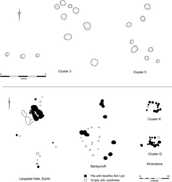
Having identified these individual site signatures, it is necessary to further interrogate the character of the pit site and the individual pit clusters and pits that form it. In terms of their size/dimensions the clusters comprised 5–11 pits and occupied areas 7–15 m across. The pits formed loose clusters, comparable to other local pit sites at Barleycroft Paddocks (Evans et al. Reference Evans, Pollard and Knight1999) and Langdale Hale (Evans et al. Reference Evans, Brudenell, Patten and Regan2013), rather than the ‘tight’ clusters at Kilverstone (Garrow et al Reference Garrow, Beadsmoore and Knight2005: see Fig. 13), yet as at the latter, their separation was clearly defined. The pit site(s) at Kilverstone, has been interpreted as a palimpsest of individual pit clusters, which represent discrete episodes of occupation of limited duration probably resulting from repeated visitations, by one or more groups (ibid.). This interpretation was based not only on the spatial separation of the pit clusters but also on the material connections (refits) between individual pits within (but not between) pit clusters. A similar model of short lived, small scale occupation has also been applied to the pit site at Spong Hill, Norfolk based largely on stylistic differences between pottery assemblages from different clusters (Healy Reference Healy1988; Reference Healy2013). Should the pit site at North Fen be interpreted in a similar way? Do the pit clusters represent separate episodes of activity or, given their apparently structured linear arrangement along a sand ridge/river terrace, are they perhaps separate ‘units’, or even households, within a contemporary settlement?
Pit cluster morphology

The pits themselves contained the by now familiar suite of Early Neolithic material: variable (but sometimes substantial) quantities of flint and pottery together with more limited evidence of crop cultivation/processing (cereal grains and a rubber stone) and animal husbandry, as well as the exploitation of wild resources (represented largely by charred hazelnut shells). No attempt is made to discuss the potential function/role of pits – ideological or practical – given that there is little within the evidence to further a debate which is widely discussed elsewhere (see Garrow Reference Garrow2006; Loveday Reference Loveday2012; Darvill Reference Darvill2012, for examples of the many and varied hypotheses regarding Neolithic pits generally). However, it is clear that material assemblages within the pits were almost certainly derived from surface deposits/‘middens’ with no evidence of structured or selective deposition (cf. Kilverstone, Garrow et al. Reference Garrow, Beadsmoore and Knight2005). Indeed that artefacts were not being specially selected for deposition in the pits is emphasised by the fact that potentially ‘special’ items such as fineware pottery and flint tools were found in high proportions within Scatter A but significantly not in the pit clusters i.e. the reverse of what might be expected.
At Kilverstone, the main technique for analysis of the pit site comprised refitting pottery sherds and flint to establish material connections between pits (Garrow et al. Reference Garrow, Beadsmoore and Knight2005). The same strategy was employed during the analysis of the North Fen material, however, it was not possible to demonstrate the same clear connections between pits within clusters. Indeed, refitting flints were found within only two adjacent pits in Cluster 6 (F.66 and F.74), whilst no pottery refits were recorded between pits in an individual cluster (albeit sherds from the same vessel were certainly present in paired pits F.66 and F.74). Interestingly, however, pottery sherds from the same vessel (two of which refitted) were found in individual pits in separate clusters (F.49 and F.50 in Cluster 3 and F.74 in Cluster 6), therefore, establishing a ‘connection’ between clusters. Significantly, these four ‘connected’ pits also yielded the most finds – by quantity and weight – of any of the recorded pits. On this evidence, therefore, Clusters 3 and 6, although spatially discrete, appear not to represent completely separate occupation episodes. As a result, it is possible to argue that the pit clusters within the main pit site, represent a single extended episode of occupation – albeit one which Bayesian analysis of the radiocarbon results suggests may have been comparatively brief (1–65 years at 68% probability) – rather than a series of visitations.
The unequal deposition of material within each pit cluster (Fig. 14), whereby some pits/clusters contained little or no evidence of a direct association to nearby domestic occupation whilst further undermining the notion that at North Fen each pit cluster represents its own self-contained/discrete settlement episode, also suggests that clusters do not necessarily equate to individual households. Whilst the material assemblages from pits F.49, F.50, F.66, and F.74 in Clusters 3 and 6 suggest an immediacy to their deposition – near complete pottery vessels and coherent flint assemblages being quickly deposited within pits – other pits/clusters appear to hold little more than soil containing the residues of nearby occupation (cf. the pottery and flint assemblages of Scatter A). This potentially holds true for Clusters 4 and 5, while only seven flints (of which six are small chips recovered from sieved sample residues) from seven pits in Cluster 7 suggests that there was simply no occupation nearby. Consequently, though it is tempting to see the linear arrangement of spatially separate areas of activity as a series of individual households (whether this be in the form of campsites, temporary structures or more permanent ‘houses’), the scale of deposition, certainly within Cluster 7 and to a lesser extent in Clusters 4 and 5 strongly suggest the settlement layout cannot be interpreted in such a straightforward manner.
Pottery and flint deposition within pit clusters

Potentially this variation in the character and size of pit cluster assemblages results from their location with regard to different activity zones within a contemporary settlement and particularly their proximity to midden heaps. It seems likely Clusters 3 and 6 were located at or close to midden heaps, with certain individual pits being contemporary with their accumulation; hence the immediate character of the deposition in pits F.49, F.50, F.66, and F.74. The pottery refits suggest that these midden heaps were broadly contemporary and either in use at the same time or in succession. At the other end of the scale, pit Cluster 7 was clearly something of an ‘outlier’ and was presumably located well away from any midden or settlement activity. The site’s ‘isolated’ pits, most notably F.68 on the western edge of the pit site, can be seen in much the same way. Occupying a middle ground both spatially and in terms of finds quantities, Clusters 4 and 5 were probably not located close to a midden heap but still contained the residues of occupation albeit in limited quantities. In being effectively bracketed by midden heaps close to Clusters 3 and 6, this area can potentially be seen as the core of the settlement; an area which was kept relatively, although inevitably not completely, clean and was perhaps the most likely location of any living area/structure(s).
The pit clusters still, however, clearly existed as individual entities. It is possible therefore that they equate to – or are the result of – distinct areas of activity within an organised/structured settlement layout, including features such as structures and midden heaps as well as task-specific zones. With the exception of the pit clusters themselves, such features/zones appear to have left no archaeological trace and in this sense the ‘spaces in-between’ take on increased significance. That pits effectively clustered around the locations of structures has been considered (if not readily accepted) by Garrow (Reference Garrow2006) with regard to Kilverstone and more generally by Bradley (Reference Bradley2007). The more recently excavated site at Horton, Berkshire also recorded a convincing ‘house void’ defined by Early Neolithic pits, which post-dated a nearby Neolithic house – one of four definite Neolithic houses now recorded at the site (Chaffey & Brook Reference Chaffey and Brook2012; Wessex Archaeology 2013). Significantly, although many of the large ‘long hall’ type structures of the period have been interpreted as part of a monumental architecture of the primary Neolithic (eg, Garwood Reference Garwood2011; Thomas Reference Thomas2013), evidence suggests that the Horton example was, for a period at least, a domestic building (Chaffey & Brook Reference Chaffey and Brook2012). There is, of course, no definitive evidence of Early Neolithic structures at North Fen and across East Anglia generally they appear rarely in the archaeological record. Evidence is limited to individual structures recorded at Gorhambury, Hertfordshire (Neal et al. 1990, 8–9) and the Stumble, Essex (Wilkinson et al. Reference Wilkinson, Murphy, Brown and Heppell2012), and a sub-square building and two less confidently dated post-hole structures recorded during the various excavations at Fengate, Peterborough (Pryor Reference Pryor1974; Evans et al. 2009). This does not, however, preclude their more widespread existence or even that they could have been relatively substantial and that their lack of archaeological visibility may be a consequence of building technique (eg, sill beam); it is worth noting that without the presence of eaves drip gullies many later prehistoric houses would not be archaeologically visible, even on well preserved fenland sites where buried soils and occupation layers survive (eg, Barleycroft Plant Site; Evans et al. Reference Evans, Tabor and Vander Linden2014).
Settlement and the wider landscape
The North Fen evidence clearly reflects multiple episodes of activity; Scatter A and the pit site are best interpreted as separate episodes of occupation and potentially Scatter B and pit Cluster 1 represent further separate events. Each was slightly different in character and represent a variety of activities potentially ranging from relatively prolonged settlement (long enough at least for substantial midden heaps/surface deposits to accumulate) to short-lived task specific forays. Yet interrogating the evidence at a site scale clearly has its limitations and in order to gain further insight into the scale, duration and character of activity it is necessary to consider the site at a landscape scale.
The number of nearby Neolithic sites, many of them on the Chatteris ‘mainland’ to the north, is striking (see Fig. 2). Including the SUT 1 site (corresponding with the location of the site’s pit clusters), 11 artefact scatters were recorded by the Fenland Project within a 3 km radius of North Fen; some comprised only flint, whilst others also contained pottery and animal bone and were interpreted as ‘occupation sites’ (Hall Reference Hall1992; Reference Hall1996). The density of Neolithic sites in the area can to some extent be explained in terms of archaeological visibility – the peat and alluvial cover in this area is clearly thick enough to have preserved scatters yet shallow enough to allow for their partial exposure by ploughing – nevertheless, the number of sites in the area is high. Consequently, while these have as yet only been broadly dated as Neolithic (ibid.) it seems likely that the North Fen/southern Chatteris area should be regarded as a particular focus for settlement, potentially throughout much of the period.
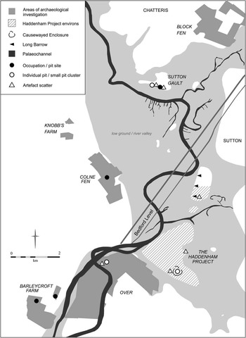
Beyond the site’s immediate environs, earlier Neolithic activity is widely recorded in the landscape (Fig. 15), perhaps most notably by the Haddenham Project (Evans & Hodder Reference Evans and Hodder2006). Three long barrows have been identified within the Haddenham environs at Foulmire Fen, one of which has seen excavation as part of the project along with the causewayed enclosure at the Upper Delphs. Whilst occupation related activity – including flint scatters and pottery – was recorded at both monuments and within the environs, the complicating factor of its relationship with the monuments themselves precludes direct comparison with North Fen, as does the less intense sampling methodology employed by the project. It is interesting, however, that the causewayed enclosure was notable by its paucity of evidence for large gatherings/extended use (Evans & Hodder Reference Evans and Hodder2006).
Early Neolithic sites and areas of archaeological investigation in the wider landscape

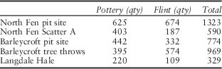
Other significant excavated sites occur at Barleycroft Paddocks (within the Over/Needingworth Quarry; Evans et al. Reference Evans, Tabor and Vander Lindenforthcoming) and Langdale Hale at Colne Fen, Earith (Evans et al. Reference Evans, Brudenell, Patten and Regan2013). At Barleycroft substantial plain bowl pottery and flint assemblages recovered from two tree-throws and an adjacent pit cluster yielding flint and Mildenhall pottery assemblages have been interpreted as evidence of primary clearance and subsequent occupation within the clearing respectively (Evans et al. Reference Evans, Pollard and Knight1999). At Langdale Hale, a smaller pit cluster and tree-throw with correspondingly smaller artefact assemblages was recorded, together with a number of more isolated pits, amongst dense Roman settlement remains. The comparative size of the pottery and flint assemblages from both sites is shown alongside those from North Fen in Table 6.
Early Neolithic Occupation Sites in the Southern Fens

The largest scale archaeological exposures within the landscape have occurred at The Over Narrows (across the River Great Ouse from Barleycroft) and the results of these investigations have a significant bearing on how we understand Early Neolithic occupation, despite the comparative dearth of evidence dating to that period at the site (Evans et al. Reference Evans, Tabor and Vander Linden2014; Reference Evans, Tabor and Vander Lindenforthcoming). Whilst evidence of significant occupation from the later Neolithic through to the Late Bronze Age has been recorded, only a single pit containing 15 flints dated to the Early Neolithic. Furthermore, amongst the site’s substantial artefact scatters, a large proportion of which comprised later Mesolithic material, only a minor Early Neolithic component was detected (ibid.). As such, despite occupying a prominent sandy ridge (a strikingly similar situation to North Fen) and being located in an area which saw significant occupation in other periods, during the Early Neolithic any activity seems likely to have been limited and probably task-specific. The same can be said for other investigated sites covering large tracts of the landscape (Knobbs Farm, Somersham: eg, Collins Reference Collins2010; Block Fen, Chatteris: see Knight Reference Knight2013 for summary) where the Early Neolithic evidence is limited only to ‘stray’ finds. Garrow (Reference Garrow2007, 10), in his study of Neolithic landscape occupation and deposition in East Anglia suggests that at a regional level pit sites appear to occupy certain places whilst artefact scatters and stray finds are ‘almost everywhere’; it can be argued that in many ways the same pattern occurs within the immediate Southern Fens landscape. As such, looking at the evidence as a whole, North Fen and Barleycroft stand out as clear settlement foci within a landscape, which for the most part probably only saw ephemeral activity or ‘tasking’; Langdale Hale perhaps sits somewhere in between whilst the character of the occupation within the Haddenham environs was almost certainly bound up with the usage of the causewayed enclosure and long barrow.
In summary a series of sites operating at different scales of activity appear to occur across the landscape within the area around North Fen (and in the Cambridgeshire Fenlands more generally; Edmonds et al. Reference Edmonds, Evans and Gibson1999). Whilst acknowledging that few of these sites are likely to be directly contemporary, this suggests a fairly structured occupation and exploitation of the landscape, involving settlement sites of relatively long duration (measured in years rather than months or seasons) and ‘off-site’ task-specific forays. That both North Fen and Barleycroft Paddocks represent the former seems highly likely while the riverside location of both represent ideal locations from which to undertake ‘tasking’ and yet maintain the attachment to place required for livestock and crop production (the latter being evidenced not only by charred cereal remains but also an early episode of clearance and probably cultivation identified in the local pollen record and dated to 4370-4265 cal bc; Peglar & Waller Reference Peglar and Waller1994, 174–9). Of course the settlement activity associated with the Haddenham monument group potentially represents another different type of occupation although the character and dynamics of this lies beyond the scope of this paper.
Consequently North Fen site can be defined as a settlement focus, which saw well-structured and relatively long-lived occupation; determining the true scale of settlement, however, remains problematic. Whilst Bayesian modelling has given us an indication of the potential duration of the site, the limited size of the finds assemblages in many respects undermines interpretation of the site as a settlement of any substance; the minimum number of pottery vessels recorded from the Scatter A and the pit site (13 and 15 respectively) particularly seems low. However, as demonstrated by recent excavations undertaken at Barleycroft/Over, it is possible that we are consistently underestimating the scale of occupation, which these assemblages represent (Evans et al. Reference Evans, Tabor and Vander Linden2014). While preservation at North Fen was exceptionally good and has allowed subtle traces of Neolithic occupation, such as Scatter A to be identified, the evidence still represents a ‘partial past’ (ibid.); most notably, well preserved buried soils did not survive in the area of the main pit site. It is worth noting that at the Early Neolithic site at the Stumble, Essex it has been estimated that up to 90% of the artefact assemblages may have been lost through ‘post-occupational erosion and degradation’ had the estuarine conditions not preserved the site in the way they did (Wilkinson et al. Reference Wilkinson, Murphy, Brown and Heppell2012). As such, the true scale of the settlement at North Fen and just how much of the material that it generated found its way into the pits remains unknown.
Finally, we should also consider that perhaps the apparent lack of evidence for substantial/‘permanent’ settlement sites is because any attachment to place is better understood in terms of the wider environs of North Fen and the area to the south of Chatteris generally, rather than any one particular settlement site. It is clear that although it should be considered as an extended episode of occupation, the pit site in particular did not apparently see significant reorganisation/multiple phases; it was in effect one comparatively brief settlement phase. That the area around North Fen was the focus for numerous separate settlement sites, is evidenced not only by the sites exposed during the excavation but also by those recognised by the Fenland Project (Hall Reference Hall1992; Reference Hall1996). That the location of any specific occupation site shifted within a broader settlement zone with relative regularity would satisfy the need to be attached to a location whilst also explaining the apparent lack of sustained permanent settlement sites. The majority of Neolithic structures (assuming they existed in some form) may have had a relatively limited lifespan, for example, while the fertility of land in the immediate vicinity of these structures may well have been exhausted over such a period. Potentially, both these factors, as well as others, provided the impetus for small scale movement within a limited area. As such the settlement can potentially be seen as ‘embedded’ not at a specific site, but within a defined landscape zone.
Conclusion
It is suggested that North Fen functioned as a settlement base from which frequent ‘tasking’ was undertaken by some or all of its Early Neolithic inhabitants; individuals or small groups may have spent much of their time moving around the landscape, however, it also seems that as a population they were ‘tied’ to a locale. For whilst tasking and the exploitation of wild resources clearly formed a major part of the Neolithic economy, so did agriculture, thus requiring a commitment to place. Both are evident not only in aspects of the North Fen site(s) with their individual ‘site signatures’ but also arguably within this part of the Lower Ouse valley generally where a relatively clear distinction can be made between widely recorded evidence of short-lived task specific activity and a small number of occupation sites of longer duration.
This is not to say that such an interpretation could or should be applied to other Early Neolithic sites/landscapes or necessarily held in opposition to interpretations, which see occupation as more episodic (eg, Kilverstone; Garrow et al. Reference Garrow, Beadsmoore and Knight2005). Neolithic occupation was in all likelihood complex, changing and variable and it is important to move beyond characterising sites according to broad models and generalised concepts of sedentism or mobility. As emphasised by Thomas (Reference Thomas2004) it is vital to consider how localised communities exploited their landscape, how they utilised the Neolithic ‘package’ (specifically in this case material culture and agriculture) and to what extent this is likely to have varied across Britain. The fact that an interpretation that ‘fits’ for the Kilverstone pit site, for example, does not translate to the North Fen pit site – which appears different in terms of pit cluster morphology and layout, as well as in its depositional practice – is potentially a reflection of individual sites functioning in differing ways in different landscapes, and further emphasises the need for continued discourse and individual interpretation of earlier Neolithic sites.
Acknowledgements
The CAU would like to thank Richard Lee of P. J. Lee and Sons Ltd for funding the excavation and Richard Bull of Darlington Bull Ltd who acted as consultant. The project was monitored by Andy Thomas of Cambridgeshire Historic Environment Team and was managed on behalf of the CAU by Emma Beadsmoore. The author wishes to thank Frances Healy, Emma Beadsmoore and particularly Chris Evans for their comments and editing skills. The report graphics were produced by Andy Hall and Jane Matthews whilst the finds illustrations are the work of Vicki Herring. Photographs were taken by the author (Fig. 3) and Dave Webb (Fig. 6). Thanks also go to David Hall who kindly provided permission to use the original English Heritage funded Fenland Project graphic in Figure 2. Finally, the efforts of the CAU’s excavation and post-excavation teams, too numerous to mention individually, are gratefully acknowledged.
Supplementary Material
To view supplementary material for this article, please visit http://dx.doi.org/10.1017/ppr.2016.2