

Promoters of the “new” history of cartography have informed us that printed maps were more than mere geographical representations. In Brian Harley's words, they “articulated symbolic values as part of a visual language by which specific interests, doctrines, and even world views were communicated.”Footnote 1 Harley argued that printed maps should be deconstructed as texts, because despite their claims to scientific accuracy of mimetic representation, maps were not value-free and innocent, but rather were laden with political and ideological messages. By the early modern period, “mapmaking was one of the specialized intellectual weapons by which power could be gained, administered, given legitimacy, and codified.”Footnote 2 Other historians have agreed that a chief purpose of early modern maps was to demonstrate boundaries, frontiers, and the eminent dominion and empire of a sovereign monarch. The new ability of monarchs to “see” the extent of their dominions and to convey the desired official view of the territories in question through publication turned maps into political tools of the sovereign authority for whom the mapmaker worked.Footnote 3 This is why, in late-Tudor and early-Stuart England, crown officials were the most important patrons to cartographers. Consistent with the desires of their patrons, mapmakers included various rhetorical devices, intentional statements that were designed to be persuasive and impressive. Maps displaying royal and aristocratic coats of arms, ships in the seas displaying the English ensign, distinctly Anglicized place-names, and descriptive narrative cartouches attested to English sovereignty and crown authority over all or part of the region depicted on the map.Footnote 4
Early English printed maps of North America contained political and ideological statements that were often more powerful than those represented in maps of the British Isles. This is because these frontier regions were more likely to draw the attention of an international audience and to have less-defined, disputable boundaries. When examining English-drawn maps of this period, historians generally focus on the lack of geographical accuracy and cartographical skill evident in these documents, especially in comparison to maps simultaneously produced by the Dutch.Footnote 5 Benjamin Schmidt, for example, has observed that in comparison to Dutch maps, “English printed maps of America were inadequate: limited, derivative, or just plain inferior.”Footnote 6 When considering these maps in the historical context of the first, uncertain half-century of English colonial settlement, however, there were more important issues at stake than cartographical accuracy. More than perhaps any other medium, maps literally defined North America's potential for colonization in the minds of the English and continental Europeans.Footnote 7 As J. R. Short writes, “geographic representations of the New World were always tied to the claiming of the New World.”Footnote 8 This made the information communicated through maps especially important in the process of expressing sovereignty in overseas territories.Footnote 9 The competition between England, France, the Netherlands, and Spain (and the contemporary diplomatic correspondence suggests that the competition was at times intense) required that a blanket of secrecy surround much of the detailed knowledge collected about New World geography, lest certain revelations provide assistance to other colonizing powers. At the same time, the resurgence after the Reformation of the jus gentium (law of nations) and civil law to adjudicate the relations between sovereign states required that colonizing powers demonstrate their sovereignty in the New World in ways that could achieve international recognition.
Given the need simultaneously to protect secret intelligence about, and express sovereignty over, newfound lands, the question of accuracy in English printed maps of North America becomes subordinate to another question: What did the mapmakers and their patrons want others to know about North America? This investigation of English maps of North America from about 1580 to 1625 reveals that, for reasons of security and secrecy, the best geographical knowledge conveyed through English-drawn maps of newfound lands remained in manuscript, so that the crown and the trading companies solely could benefit from this valuable intelligence. Printed maps of newfound lands were usually optimistic, speculative, and unrepresentative and could be used as propaganda without compromising secret intelligence. They contained a number of rhetorical devices that demonstrated English sovereignty, perpetual crown authority, and complete territorial possession and effective control, all of which were important assertions according to the jus gentium. Cartographers made a claim to sovereignty that was much stronger than could be made through mundane or ceremonial acts of possession, or in English-language descriptions of the territory. It is the latter expressions of sovereignty in the New World that have been occupying scholars in recent years, even though these methods all had limited audiences, were difficult to prove, and had relatively little agency in the law of nations.Footnote 10 Moreover, after their initial, crown-authorized publication in English books, many of these maps were subsequently republished, either in their original form or with minor changes, by continental cartographers, largely in response to the immense popularity of decorated maps in the early modern period. This gave an international audience to these maps and, regardless of cartographical accuracy, offered the possibility that other Europeans would better recognize English sovereignty in newfound lands.
Manuscript Maps and the Policy of Secrecy
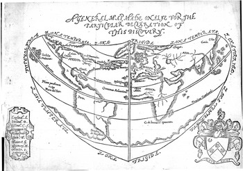
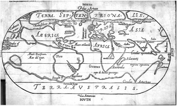
The first published English maps of newfound lands were cartoon-like in their simplicity. Humphrey Gilbert's 1576 map of the world, which appeared in his A Discourse of a Discoverie for a New Passage to Cataia, was a pseudo-cordiform map that was optimistic and speculative (fig. 1).Footnote 11 Overseas territories much desired by the English are depicted as being proximate and easily accessible. Greenland, Labrador, and “Canada” are shown too close to the British Isles, which makes them highly relevant to English interests and, perhaps, gives Queen Elizabeth a stronger claim to them. The wealthy islands of “Giapan” (Japan) and the “Insulae Molucae” (the Molucca Islands) are virtually at the egress of an easily navigable northwest passage. A similar map by George Best was published in his True Discourse of 1578 (fig. 2).Footnote 12 Representing the world less accurately and even more optimistically than Gilbert's, Best's map shares all of the same characteristics: China, Japan, and the Spice Islands are easily accessed through a wide Frobisher's Strait that runs across the entire northern coast of North America. Michael Lok's map of North America, which appeared in Richard Hakluyt's Divers Voyages (1582), was the most widely distributed of the three. While having the pretense of accuracy through the use of latitude and longitude lines, it is the least accurate of
—Humphrey Gilbert, Discourse of a Discoverie, 1576. Reproduced by permission of The Huntington Library, San Marino, California.

—George Best, True Discourse, 1578. Reproduced by permission of The Huntington Library, San Marino, California.

all.Footnote 13 In Lok's depiction, North America is connected at its center by a narrow body of land; while the southern part, Florida and Mexico, is clearly the dominion of the Spanish monarch, the northern part contains numerous signs of English possession. The voyages of John and Sebastian Cabot and Martin Frobisher and the years in which their discoveries were made are indicated. Lok's message is clear: the English have sovereignty, based on the precedent of first discovery, over a large land mass whose borders are easily identifiable.
Gilbert, Best, and Lok were propagandists and explorers, not cartographers, and they probably prepared their maps from earlier European drawings.Footnote 14 But by the 1570s much better information than they published was available. The advanced projections of the continental cartographers Gemma Frisius, Gerhard Mercator, and Abraham Ortelius were all available through atlases and globes. Mercator's mappamundi of 1569 was perhaps the most familiar cartographical representation of the late sixteenth century and was widely available to English viewers. It contained the so-called Mercator projection, the modern method of centering the world map on Western Europe and including latitude and longitude lines to provide a perspective.Footnote 15 English geographers and cartographers, too, had far more knowledge than was demonstrated in Gilbert's and his contemporaries' printed maps. As Lesley Cormack, Richard Helgerson, and others have shown, England was fully involved in the cartographical revolution that occurred in Europe during the sixteenth and seventeenth centuries. The revolution was marked by improvements in land surveying and measuring, the inclusion of scales and latitude and longitude lines in maps, the removal of speculation about the unknown from maps, and the increase of map ownership, use, and display. In the period after 1580, geography and related sciences were popular fields of study in English universities and an important part of English discourse.Footnote 16
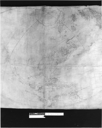
The English polymath John Dee's three manuscript maps, drawn between 1580 and 1582, are considerably more accurate than those English maps simultaneously published. Dee, who was trained by and remained in contact with Frisius, Mercator, and Ortelius, conformed closely to the new learning on mapmaking.Footnote 17 All of these maps remained in manuscript throughout the age of exploration. The first of the 1580 maps shows remarkable scientific accuracy for the time (fig. 3).Footnote 18 Dee included latitude and longitude lines and, where possible, place-names and accurate representations of the geography. Dee's knowledge of the eastern seaboard of North, Central, and South America and of the West Indies was impressive. In this respect, Dee's map is one of the most comprehensive of the time. On the West Coast, Dee mapped what he could determine from other sources, which was the coastline of Central America northward to about Oregon, the region that Drake had recently discovered. The entire northwest portion of North America is blank on the map, because Dee did not have enough information and clearly did not wish to speculate. This map, which was given to Elizabeth or a senior advisor, was probably designed to assist the crown in future exploratory voyages and to assist sea pilots in their travels.
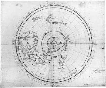
Another of Dee's maps, also drawn in 1580, was found among the extensive map collection of William Cecil, Lord Burghley. The value of Dee's map to Burghley and the English state may be assumed by the fact that it was sandwiched between two folios of Ortelius's famous atlas, Theatrum Orbis Terrarum (1570). To the English at least, Dee was deemed to be on par with the leading cartographers of his age. Drawn from a northern perspective, Dee's projection shows 200 degrees of longitude and 50 degrees of latitude, stretching eastward from England to China, and conforming to the speculations that Dee made in his lengthy manuscripts entitled “Of Famous and Rich Discoveries” and “Brytanici Imperii Limites.”Footnote 19 Although its provenance is uncertain, this map was probably similar to the one Dee prepared for Charles Jackman and Arthur Pett in 1580 to help in their search for the northeast passage. Dee once noted that he provided them with a new chart that described the route to China “more exactly, than any other, yet published.”Footnote 20 Obviously, when offering navigational instructions Dee was concerned that the information he was giving was accurate and unspeculative. Dee's 1582 map, drawn for Humphrey Gilbert, is less accurate than those of 1580, though it is still far more detailed and scientific than the
—John Dee's map of the Northern Hemisphere, 1580, British Library Cotton MS Augustus I.i.1. Reproduced by permission of the British Library.

published maps of the period (fig. 4). He made the same error as his contemporaries in assuming the existence of an easy northwest passage, and he conceived of the St. Lawrence stretching westward and emptying into the Pacific Ocean. If this was true, of course, another potential sailing route to China and the East Indies existed, and within this context Gilbert's plans to
—John Dee/Humphrey Gilbert map of the Northern Hemisphere, 1582. This item is reproduced by permission of the Rare Book Department, the Free Library of Philadelphia.
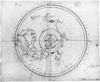
colonize and fortify Newfoundland made perfect sense.Footnote 21 This map seems to have had a more propagandistic purpose than the 1580 map.
If such accurate information was available from respected European and English cartographers, why did Lok and his contemporaries print maps that they must have known were unrepresentative? The answer is that the English crown was concerned about disseminating intelligence that would prove advantageous to other Europeans. As Cormack argues, the more the English came to know about the world through geography and cartography, the more interested they were in exploring, writing about, and establishing authority over parts of it.Footnote 22 Therefore, the knowledge conveyed through maps was highly esteemed and was to be carefully guarded for fear of giving an advantage to other countries. Secrecy and the monopolization of knowledge were vital to the success of early English activities in newfound lands. This is why George Best, on the title page to his A True Discourse, defended the simplicity of his maps by writing that they depicted Frobisher's North Atlantic activities “so far forth as the secrets of the voyage may permit.”Footnote 23
Secrecy was the prevailing official crown policy. When Francis Drake returned from his circumnavigation in 1580, he presented Queen Elizabeth with a “very large map.” So the Spanish Ambassador Bernardino de Mendoza reported to Philip II.Footnote 24 Drake was also required to pass his journal, without making a copy of it, to Lord Burghley. This is no longer extant, but it was apparently illustrated with maps “so naturally depicted that no one who guides himself according to these paintings can possibly go astray.”Footnote 25 The journal was not available for public viewing. Richard Hakluyt could not consult it for his Principall Navigations of 1589, and Drake himself was forbidden access to it when he was planning to publish an account of his own voyage in order to correct misrepresentations. Only the queen and her inner circle were allowed to share the secrets of Drake's voyage, for Drake and all others were strictly warned against disclosing his route or any particulars that would allow another nation to repeat his voyage, a prohibition that still existed into the seventeenth century.Footnote 26 Even in John Dee's “A discourse of the voyage made by Master Francis Drake,” a treatise written in May 1580 for a popular audience, geographical references are noticeably absent, especially given Dee's considerable technical knowledge and his tendency to provide remarkable hydrographical detail when presenting material to the court.Footnote 27 Nor was Dee by this time a stranger to the policy of secrecy. When he desired to publish his “Of Famous and Rich Discoveries” in 1578, in which he had written about Frobisher's activities and early English forays into the East Indies, the queen seems to have refused to allow its publication because of the amount of detail it contained.Footnote 28
The cartographical truth of Frobisher's and Drake's voyages was not the only suppression in this period. In his instructions to Humphrey Gilbert in 1582, Edward Hoby, Lord Burghley's nephew and an employee of the crown, told the explorer to “note the particular place where every such thing shall be found” and to “note all the islands, their bigness, commodities, and havens, and the elevations of every isle and set down this same both in your maps and journals.”Footnote 29 As in Drake's voyage, these were to be turned in to the court, which would determine how best to use the intelligence. In the same year, Lord Burghley and Sir Francis Walsingham, the secretary of state, gave a set of instructions to Edward Fenton, captain-general of a voyage to the East Indies. The eighteenth article instructs that “you shall give straight order that none shall make any cartes [i.e., charts or maps] or description of the said voyage, but such as shall be deputed by you the general, which said charts and descriptions we think meet that you the general shall take into your hands at your return to this our coast of England leaving with them no copies, and to present them unto us at your return, the like to be done if they find any charts or maps in those countries.”Footnote 30 Like the orders to Drake and Gilbert, the purpose of this article was to ensure that any geographical knowledge obtained through the voyage was presented to the crown for its benefit, but that the information not be allowed to leak to the general public and foreigners.
In 1596, Walter Raleigh returned from his voyage to Guiana and reported to Robert Cecil, the queen's new chief minister, that “how all these rivers cross and encounter, how the country lieth and is bordered … your Lordship shall receive in a large chart or map, which I have not yet finished, and which I shall most humbly pray your Lordship to [keep] secret, and not to suffer it to pass your own hands; for by a draught thereof all may be prevented by other nations. For I know it is this very year sought by the French.”Footnote 31 Raleigh's manuscript of Guiana, not unlike Dee's 1580 map of North America, is quite detailed and might well have cost English (or, later, Irish) lives or control of the then-important El Dorado region if it ended up in the wrong hands.Footnote 32 A decade later, James Rosier, a traveler to New England, reported that “because some foreign nation … have hoped hereby to gain some knowledge of the place … this is the cause that I have neither written of the latitude or variation most exactly observed by our Captain.”Footnote 33 The earliest known detailed chart of the Chesapeake region of Virginia, drawn by Robert Tindall in 1607 and entitled “a draught of Virginia,” also remained in manuscript.Footnote 34 If the instructions to earlier Elizabethan explorers are any indication, the discretion shown by Raleigh, Rosier, and Tindall seems to have reflected standing official crown policy.
These writers and state officials all recognized that secrecy was necessary to prevent foreign nations from learning too much about English activities in newfound lands. This was not paranoia. The Spanish, in particular, kept a close eye on English overseas affairs and received considerable intelligence from their ambassadors resident in London. In 1578, Mendoza reported to his king that he was “very hopeful of being able to obtain a chart of Frobisher's voyage,” a telling indication of how valuable such material was to foreign powers.Footnote 35 In 1608, Ambassador Zúñiga managed to get hold of Tindall's draft map of Virginia, which rather poorly depicted the region from Cape Henry to the Potomac River, and sent this to the king of Spain. Three years later, a copy of a detailed map of the entire northeast coast of North America, from Newfoundland to the Chesapeake, which was made for James I in 1610, was sent to the Spanish king by the new ambassador in England, Don Alonso de Velasco. Although the original is not extant, the fact that the writing on the map is in English and not Spanish suggests that it is a direct copy. In the lower left corner of the “Velasco map” there is a numbered table listing the names of rivers and towns settled by the English, which correspond to numbers on the mainland.Footnote 36 Both the “Zúñiga map” and the “Velasco map” were received in Spain at the same time that the English ambassadors were warning their superiors in England about an impending armada assembling to attack Virginia.Footnote 37 Clearly, given such a challenge, these maps contained intelligence that the English crown would have preferred remain secret.
Sovereignty and the Law of Nations
The crown policy of secrecy should not lead us to the conclusion that English and European audiences were denied cartographical details of English activities in newfound lands. Printed maps were an important way for explorers to convince others of the worthiness of their overseas successes and an immensely popular art form in the early modern period, both of which worked to the favor of the English crown.Footnote 38 Without divulging information that the crown wanted to monopolize for its own purposes, considerable information could still be made public through carefully prepared and disseminated maps demonstrating sovereignty and possession. The crown knew that publishing information about newfound lands was the best way to inform England and the world of its assertions of sovereignty in certain regions and to gain, through implicit acquiescence, the recognition of the international community. These were not simply the boastful acts of proud monarchs. In the late Tudor and early Stuart period, recognized expressions of sovereignty by a supreme monarch were essential aspects of internal state building and nascent supranational law. Beginning shortly after the Protestant Reformation, rulers throughout Europe were proclaiming their independence from Rome and the Holy Roman Emperor and presenting themselves as rulers who recognized no higher earthly authority. These ideas were affirmed by the Dominican friar Francisco de Vitoria (1480–1552) in Spain, by English writers such as Thomas Starkey and Thomas Elyot, and by Jean Bodin in his Six livres de la république (1576), which was the most powerful statement of independent, national sovereignty written before the articles of the Peace of Westphalia in 1648.Footnote 39
With these writers denying the authority of the pope and emperor, and instead arguing that European monarchs had no higher allegiance, a system had to be established that would govern the relations between sovereign states. It is in this regard that the jus gentium becomes especially relevant. It was a common body of law, informed by a combination of custom and written (or positive) civil law, that, as Vitoria wrote, “has the sanction of the whole world.”Footnote 40 By the late sixteenth century, the relevance of the jus gentium in adjudicating supranational affairs had been accepted in England by the Italian emigrant Alberico Gentili, who was regius professor of civil law at Oxford under Queen Elizabeth. Within a decade various English writers were declaring that “the law of nations … is observed alike in all nations.”Footnote 41 As James Muldoon has recently pointed out, European activities in newfound lands, matters that involved extraterritorial acquisitions and controversies, were inextricably linked with the law of nations. Given the need to receive the consensus of the international community, a primary concern for monarchs acquiring territory was employing methods that would lead to international recognition.Footnote 42 Similarly, Kent McNeil has written that “for an assertion of sovereignty by the Crown to be effective internationally the criteria of the law of nations relating to the acquisition of territory would have to be met.”Footnote 43 If these claims failed to achieve the consensus of the international community, English monarchs ran the risk either of being drawn into a battle (whether rhetorical, diplomatic, insurgent, or belligerent) that could lead to usurpation of the territory or the possibility that their claims to territory could be challenged at some time in the future.
The modes of acquiring territory were codified by the Emperor Justinian in the sixth century a.d. as part of his Corpus Juris Civilis. Ever since the recovery of civil law that accompanied the rise of legal humanism during the Renaissance, this legal codex was well known to English and European lawyers. Justinian's Corpus was based on the writings of such well-known Roman statesmen and jurists as Cicero, Seneca, and Tacitus. It was also the basis of all nonreligious legal education in both English universities in the sixteenth and seventeenth centuries. Footnote 44 Part of the Corpus is comprised of the Digest, in which an important chapter—book 1, chapter 41, entitled “Acquisition of ownership of things”—has the most important legal precedents regarding possession and use of land and seas in all Roman jurisprudence.Footnote 45 Because there were in the sixteenth century no precepts of the law of nations governing the acquisition of newfound territories (because these were still new activities that had not yet acquired consensus), this chapter was virtually the only legal precedent of international standing from which to draw. The so-called fathers of international law, including Vitoria, Gentili, and Hugo Grotius, each of whom at some point addressed specifically the issue of acquiring sovereignty in newfound lands, all had to base their opinions on their interpretations of Justinian or his medieval glossators.Footnote 46 This usage was not inappropriate, as Justinian's Corpus of Roman Law was assembled in large part because of the new issues surrounding imperium (the right to rule) and dominium (territorial sovereignty) that were associated with the expansion of the Roman Empire.Footnote 47
Justinian identified several modes of acquisition of territory that could lead to claims of imperium and dominium. These included (1) physical occupation of empty land, which is the settlement of territory not subject to the sovereignty of another Christian state; (2) prescription, where title flows from effectual, long, continued, and undisturbed possession over a long period of time; (3) cession, the transfer of property by treaty; or (4) subjugation, the taking of possession from a conquered sovereign state.Footnote 48 It is the first two of these modes of acquisition—occupation and prescription—that are of the greatest relevance to America. Two points are of special importance. The first is that “discovery” did not form part of Justinian's modes of possession. Even in the sixteenth century, it was not legitimate to argue that mere discovery or the intent to settle land was sufficient to establish sovereignty, despite the efforts of the Spanish to employ the “preemptive” argument of first discovery wherever possible.Footnote 49 This was because, according to Justinian, intent (animo) without physical control (corpore) was not allowed in civil law. To claim sovereignty over territory there must be a “physical holding” of a region that is “governed by our control.”Footnote 50 Intent could establish only an inchoate, or incomplete, title, while physical control was required to secure a complete title.Footnote 51 The second important point is that, to Justinian, no land could be allowed to exist that was not in a state of sovereignty, which was one way that Europeans justified settling land occupied by “uncivilized” peoples. For this reason, no land could be claimed by subjects who were not acting on behalf of their sovereign. Justinian claimed that “a man possesses lawfully who possesses by the praetor's authority.”Footnote 52 By the sixteenth century, the word “praetor” could be replaced with “sovereign,” because both meant a person in whom was bestowed imperium.
For claims of occupation and prescription to be legitimate, therefore, the onus was on the sovereign state to show that this territory was effectively occupied, that the possession was authorized by a recognized monarch, and that the region continued to be ruled by that crown. John T. Juricek has aptly termed this a “dominative” code, one that was more likely to acquire consensus among the international community.Footnote 53 The efficacy of these legal precedents in the acquisition of sovereignty in newfound lands was shown when the English became engaged in disputes with other colonizing powers in the first few decades of the seventeenth century. During the negotiations for the Treaty of London in 1604, for example, Sir Robert Cotton argued that the English had made prescriptive use of North America north of Florida for over a century. He also showed that these territories were claimed by a recognized, sovereign monarch who continued to hold authority and physical control over the region. The Spanish, conversely, had not gained authority over the native peoples and had not planted in the region north of 32 degrees north latitude, which was required by the law of nations if they were to claim sovereignty over that region.Footnote 54 When the same issues arose in 1613 after the Spanish crown complained of English settlements in Virginia and Bermuda, an anonymous author argued that the rights of the English exceeded those of the Spanish. This was because the English had settled and continued to govern various parts of North America from 32 to 72 degrees.Footnote 55 After the French complaint following Sir Samuel Argall's razing of Port Royal in 1613, the English responded that the region had been possessed by them as soon as their ships had arrived in the Chesapeake Bay and established the first permanent settlement.Footnote 56 In their responses to these and other controversies, Europeans generally employed the same legal language, using its relative pliability to their own advantage.Footnote 57
In theory, the level of effective control was defined by Justinian: “When we say that we must take possession both physically and mentally, that should not be taken to mean that one seeking to possess an estate must go round every part of it; suffice it that he enters some part of the estate, but with the intent and awareness that thereby he seeks to possess the estate to its utmost boundaries.”Footnote 58 This theory was difficult to put into practice, especially when the territory under consideration had the vastness of North America, whose exact size was unknown for much of the seventeenth century. In practice, the effective control of a territory by a sovereign monarch had to be shown to the international community in ways that implied power, knowledge, physical occupation, and prescriptive use of the region. This could be done with limited effectiveness through, for instance, fortifications, planting state symbols, publishing reports of explorers' and settlers' activities, and gaining the tribute of natives. But a properly drawn and disseminated map was, perhaps, the most effective way to accomplish this practical goal. If the crown reported its claims to the world—and if these claims were supported by rhetorical devices of a distinctly English nomenclature—a precedent for possession, prescription, effective control, and territorial sovereignty could be established. The essence to the passage of information was to convey this political and ideological message without compromising secret intelligence.
The conveyance of the proper political message was accomplished through the use of crown censorship. License for publishing books came from the London Stationers' Company, which was incorporated in 1557. The company assumed the role previously held by appointed crown officials to license books printed in England. A company agent was required to review manuscripts for potential subversive elements and then refuse or allow their publication. Although certain works were published without appearing on the Stationers' Register (the list of all approved books), recent scholarship suggests that the practice of censorship was pervasive and effective, and that works that would have displeased the crown or divulged secret political intelligence would have remained in manuscript.Footnote 59 Most printed maps of newfound lands were folded into English travel narratives, and, forming part of the manuscript, they too would have been subject to censorship. When, for example, Samuel Purchas was compiling maps for his collection entitled Hakluytus Posthumus in 1625, he lamented not being able to include Thomas Dermer's detailed maps of the Chesapeake, likely because the policy of secrecy still prevailed.Footnote 60
The dissemination of the desired political and ideological message was greatly enhanced by the popularity and availability of decorated maps, especially of the new world during this period. Many maps were removed from printed books and atlases, framed, and mounted on walls. Catherine Delano-Smith, for example, after looking at numerous probate inventories, has concluded that the ownership and prominent display of decorated maps was a regular occurrence in sixteenth-century Cambridge.Footnote 61 This favorable attitude toward printed maps is also shown throughout the late medieval and early modern period in sources ranging from literature to portraiture, in which the character in certain works is depicted using or sitting near wall-mounted maps, bound atlases, and globes.Footnote 62 As we shall see below, given the number of multiple editions, often in several languages, of texts containing maps of the new world, and the number of booksellers and distributors in England and Europe, there is good reason to believe that these works were desired by Europeans on a large scale. Moreover, when compared especially to larger, colored maps available in contemporary atlases or for sale individually, these maps were often engravings from copper plates of modest size (usually octavo or quarto) printed on paper (rather than cloth), keeping their cost, and the cost of the book they accompanied, relatively low. All of this helped to ensure that these maps would receive maximum distribution.
English Printed Maps of North America
Queen Elizabeth had put Francis Drake's map on display at Whitehall, where it perished in a fire in 1698.Footnote 63 Being put on display allowed visitors to view it, which is likely how derivatives of it came to exist. These derivatives are the world map by Nicola van Sype, published at Antwerp about 1583, and the so-called Drake-Mellon world map, drawn some time after 1586. These maps were among the earliest printed maps expressly showing English sovereignty in the Americas. Van Sype probably produced his map in England; indeed, he might have been commissioned by the crown, as it was not unusual for the crown to hire Dutch cartographers.Footnote 64 The Drake-Mellon map is probably a derivative of van Sype's. Like other contemporary published maps of newfound lands, neither of these maps was detailed enough to disclose secret intelligence, but each contained expressions of sovereignty that would have pleased the English crown and served as texts of possession. The van Sype map shows mini-Elizabethan coats of arms at the Strait of Magellan and Nova Albion. The Drake-Mellon map shows flags of St. George (the English ensign, which has a white background with a red cross) planted at the same places, and also in Meta Incognita (Greenland) and the Virginia region. Both maps also contain distinctly English, or English-originated, place-names: “Meta Incognita,” named by Elizabeth I; “Virginia,” named by Walter Raleigh as a tribute to his queen; and “Nova Albion,” named by Drake. Several narrative cartouches (drawings of scrolls containing text) and pictorial insets attested to Drake's and Raleigh's activity in these regions, and through changes in coloration, the artists bisected North America between the Spanish settlement in the south and the English settlement in the north, leaving the impression that the northern parts lay open to English interests. The fact that these maps were published in the Netherlands and the continent of Europe lent a measure of acquiescence to Drake's claims in Elizabeth's name.
These claims were strengthened over the following few years and made known beyond the British Isles. In 1587, Richard Hakluyt published a map of the Americas in his edition of Peter Martyr's De Orbe Novo, which was printed in Paris.Footnote 65 The map is clearly based on Ortelius's 1570 map of the Americas, but Hakluyt, following the lead of van Sype and Mellon, has indicated that Greenland, Virginia, and the Strait of Magellan were “ab Anglis inventa” and thus “jur. Reginae Elizabetha”—”discovered by the English” and “ruled by Queen Elizabeth.” By being written in Latin and published on the continent of Europe, Hakluyt's edition would have had an international audience. Both Baptista Boazio, in the map that accompanied Walter Bigges's Summary and True Discourse of Francis Drake's West Indian Voyage (London, 1589), and Giovanni Battista Mazza, in his map of North America (Venice, 1589), give the toponym of Virginia and demonstrate that it is in the possession of the English crown. Boazio, who might actually have been employed by Francis Walsingham as official cartographer on Drake's voyage,Footnote 66 does so by planting an ensign in Virginia, which is made more authoritative and internationally recognized by his planting of a French flag at “Canada” and Spanish flags in Florida, South America, and Mexico. This map was also published in the Latin, French, and German editions of the Summary.Footnote 67 Mazza's map was the first to show Roanoke Island as an English territory. By the early 1590s, then, and only half a decade after Raleigh's temporary settlement of Roanoke Island, certain foreign mapmakers, at least, recognized English possessions in the New World. Subsequent maps of North America nearly always included the toponym “Virginia.”
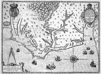
In the sixteenth century, the best representation of English possession and royal authority and sovereignty in newfound lands is found in Theodore de Bry's edition of Thomas Hariot's A Briefe and True Report of the New Found Land of Virginia (1590).Footnote 68 Hariot traveled to Roanoke with Richard Grenville in 1585 as official historian and botanist, and he spent his time there, in collaboration with the artist and later governor of the colony John White, describing the natural habitat and indigenous peoples. In 1588, Hariot published a report of his discoveries, which was mostly a list of the flora to be found in the region. Two year later, this treatise was reprinted by de Bry, a Dutch engraver and publisher, accompanied by White's drawings. Among these was included a map entitled Americae pars, Nunc Virginia dicta, primum ab Anglis inventa (The part of America called Virginia, first discovered by the English), which was de Bry's rendition of a meticulous and detailed fair-copy manuscript map prepared by White.Footnote 69 The differences between the two maps are more important than the similarities. White drew his map with north at the top, from the mouth of the Chesapeake River southward to the tip of the North Carolina Outer Banks (fig. 5). The name “Virginia” and the location of several Indian tribes are indicated in small, nonobtrusive letters. White also included drawings of seven English ships along the coast, one of which is flying the ensign, and rudimentary drawings of the royal and Raleigh's coat of arms are placed on the mainland. But for these two exceptions, White's map is unspeculative and neutral, and lacking politically motivated cartouches, legends, or decoration.
De Bry's engraving of White's manuscript map tells a different story (fig. 6). It is oriented west-east (west is at the top), an orientation that makes the land, rather than the ocean or the coastline, the primary feature. In the upper right corner is an oval, decorated cartouche, on the top of which rests a carefully drawn depiction of Walter Raleigh's coat of arms. Within the oval, we are told in Latin that the territory depicted on the map was discovered by Raleigh in 1585, under authority of Queen Elizabeth in her twenty-seventh year of lawful rule. To confirm this exercise of legitimate, royal authority, the cartouche is visually balanced with a large Elizabethan coat of arms located in the upper left corner. The royal arms speak not only of the source of authority used to claim the territory, but also the continued influence of that power over the land depicted on the map. Other symbols and images speak to the control (the “power”) that the English have established over the environment and peoples. The ocean is choppy and turbulent, contains huge sea creatures, and White's seven ships have become eight much more prominent ones, four of which are flying the English ensign. This is a statement of English prescriptive use of the region—of the bustling commercial, and perhaps military, activities undertaken by the English in America. On the mainland, the names of native tribes and their geographical location are written in large block letters. Much larger still is the word “Virginia,” which runs across the top portion of the image and gives the impression of English authority over everything depicted on the map. Finally, de Bry has decorated the vacant and unknown spaces on the land by arbitrarily placing trees and rivers, speculating about the lay of rivers that were not shown on White's map, drawing pictures of Indian men and women, and adding, at the top center of the map, a mountain range that is not part of the North Carolina landscape.
Clearly, White's and de Bry's maps differ in several important ways. The former was probably intended for use by sea captains and perhaps to assist the crown in planning its activities in this region. The land, ocean, natives, and other knowledge of the region are all shown with relative impartiality. However, for aesthetic appeal and political value there is no
—John White, “La Virginea Pars,” 1585. Reproduced by permission of the Department of Prints and Drawings, British Museum.

—Theodore de Bry's map of Virginia as it appeared in Thomas Hariot, A Brief and True Reporte (Frankfurt, 1590). Reproduced by permission of the Huntington Library, San Marino, California.

question that de Bry's map, with its multiple symbols of authority and demonstrated knowledge of the territory, is more useful to show possession according to the jus gentium. Effective control is demonstrated by filling up every inch of the land and water with pictures that show the English colonists' knowledge and use of the territory. Those viewing this map would see expressions of English sovereignty, eminent dominion, and power over places and people. Although De Bry's volume on America in which his map appeared was first published in Frankfurt, the expressions of sovereignty explicit on this map, the verbatim use of Hariot's text (which was published, we are told on the title page, under the special grace and privilege of the queen's majesty), and the dedication to Walter Raleigh, to whom de Bry professed “to remain still your humble servant,” together imply that the book was commissioned by the English. Distributed throughout Europe, his book was no doubt seen by Spanish and French subjects who also had pretensions to these regions. The popularity of this volume led to several subsequent editions printed in English, French, German, and Latin,Footnote 70 and de Bry's map was published again by William Strachey in his History of Travel into Virginia Britannia in 1622, which also went through multiple printings. White's map, on the other hand, remained in manuscript.
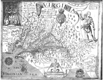
The maps of Virginia and New England, produced in 1612 and 1616, by Captain John Smith, brought the use of de Bry's rhetorical devices to near perfection. The map of Virginia was folded into a pamphlet published in the same year tellingly entitled A Map of Virginia, with a Description of the Country, the Commodities, People, Government and Religion.Footnote 71 This title makes it clear that it is the large, folded map (which is the size of two folio sheets), and not the text, that is the central document in this small quarto volume. To supplement the map, Smith included a detailed description of Virginia: “Virginia is a country in America that lieth between the degrees of 34 and 44 of the north latitude. The bounds thereof on the east side are the great Ocean. On the South lieth Florida: on the North nova Francia. As for the West thereof, the limits are unknown. Of all this country we purpose not to speak, but only of that part which was planted by the Englishmen in the year of our Lord, 1606.”Footnote 72 All of this information, Smith assured the reader, is “more plainly described by this annexed Map, which will present to the eye, the way of the mountains and current of the rivers, with their several turnings, bays, shoals, isles, inlets, and creeks, the breadth of the waters, the distances of places and such like.”Footnote 73 In making the map such a prominent feature of the treatise, Smith has emphasized that everything he describes in the remaining thirty pages, including geographical landmarks and the disposition of the native peoples, is authentic and incontrovertible. The map serves as the locus for the narrative, and together they both function as expressions of sovereignty.
Even more so than de Bry's map of Virginia, Smith represents effective occupation by filling up the entire space, and sovereign authority through symbols and images (fig. 7). Smith shows a much smaller portion of America than de Bry, focusing on the Chesapeake region itself, which is disproportionately emphasized by orienting the map with west at the top. At the top of the map, a cartouche in the form of an unrolled ribbon proclaims in large letters that the land is known as “Virginia.” Just below it is a prominently displayed royal coat of arms, and at the bottom of the map, in the water, is an English ship. On the land there are thirty-two English place-names, including Capes Henry and Charles, named after the sons of King James I, and Jamestown, named after the king himself. These toponymic references demonstrate English presence and offer tribute to the authority responsible for their existence, the English monarch. Smith makes this clear in his narrative.Footnote 74 The map is further distinguished by two illustrations representing the indigenous peoples. In the first, King Powhatan is shown sitting in the regal, though benign, fashion in which he received Smith as his prisoner in 1607. The second illustration is a large figure of a native, holding a bow in one hand and a club in the other. Both figures were probably based on prototypes taken from White's drawings that de Bry inserted into his edition of Hariot's treatise.Footnote 75 In addition, on the land there are printed the native names of ten tribes, 166 villages, and sixteen rivers. The location of approximately two dozen “King's houses” is also indicated, an emphasis on the petty nature of the native kings' dominions; in the text, Smith terms them “inferior kings.”Footnote 76 All of the
—John Smith, Virginia, 1612. Reproduced by permission of the Huntington Library, San Marino, California.

references to natives on the map suggests that a symbiosis has occurred, that the English and native peoples have intermingled, an implicit statement of England's sovereignty over the land and its peoples. This is confirmed by Smith in his legend, in which he noted that a cross on the map, of which there are approximately a dozen, represents the limits of English exploration into the region; the outlying areas have been voluntarily described by the natives for Smith's benefit. A Map of Virginia was a propagandist tract intended to induce colonization, so Smith was careful to minimize any threat from the natives, but in the process of conveying this message, territorial prescription (i.e., long and peaceful usage) and effective control are implied. That the map, though unaccompanied by the text, was reprinted several dozen times throughout the seventeenth century ensured that these messages were communicated to a wide, international audience.Footnote 77
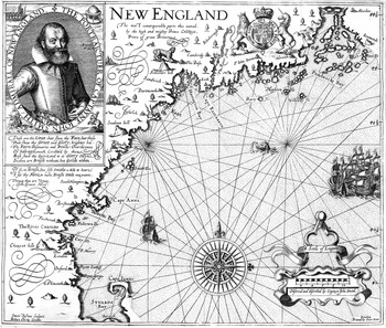
Smith's next map was of New England, which he prepared for his treatise entitled A Description of New England in 1616 (fig. 8). It is based on Smith's own explorations of the region in 1614 and on other manuscript material that was available to him. The map contains many of the same rhetorical devices as its Virginia counterpart. The significant toponym “New England,” which Smith named, is prominently displayed; in naming the territory, Smith was no doubt aware that there was by this time a New Spain and a New France. Just beside the title is the royal coat of arms, which is more elaborate than the previous rendition because astride it are the lion and unicorn, traditional symbols of England's strength and honor. In the upper left corner is a large portrait of Smith, the “Admiral of New England,” which is surrounded by images representing English land and sea power. Arriving from the direction of England is a flotilla of eight ships, all flying the English ensign. The most notable feature of this map, in comparison with the Virginia map, is the complete absence of evidence of indigenous peoples: there are no images of natives, nor any native place-names. This elision was a deliberate act of Smith. Earlier in 1616, he had sent a letter to the fifteen-year-old Prince Charles, accompanied by a manuscript copy of his map. “My humble suit is,” Smith wrote to Charles, “you would please to change their Barbarous [Indian] names, for such
—John Smith, New England, 1616. Reproduced by permission of the Huntington Library, San Marino, California

English, as Posterity may say, Prince Charles was their Godfather.”Footnote 78 Smith's manuscript map, then, contained native names for key places along the coast of New England.
Sometime after the manuscript of the Description had been typeset, but before the first edition was printed, Charles undertook the task requested of him, and although it was too late for Smith to change the names in the narrative, he did manage to procure a new engraving of his map with the new names replacing those of the natives. The new map, containing distinctly English toponyms such as Cape James, Cape Elizabeth, Plymouth, Oxford, Cambridge, Charles River, and “Stuards [sic]” Bay, was placed into the published volume. Under the title, Smith added that “the most remarkable parts [are] thus named by the high and mighty Prince Charles, Prince of Great Britain.” This, like the royal coat of arms, is an indication of the sovereign authority attached to the land. The process of renaming by the crown and of making the New England landscape mirror that of its namesake was as effective a symbol of sovereignty, possession, control, and knowledge as were coats of arms and English ensigns. In a German-language version of the Description of New England, produced by Levinus Hulsius (Frankfurt, 1617), all of the text is in German except the place-names, which remain anglicized as named by the prince. Like his map of Virginia, Smith's map of New England was republished several times.Footnote 79
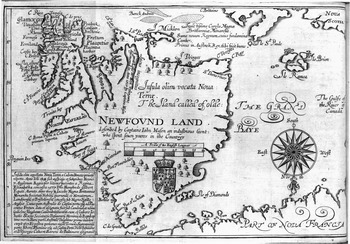
Smith's use of toponyms and description as expressions of sovereignty in his map of New England became a dominant feature of English maps of North America in the 1620s. John Mason's map of Newfoundland, published in his Brief Discourse of the New-found-land (1625) and William Vaughan's Cambrensium Caroleia (1625 and 1630), is another good example of the use of words to designate sovereign authority and effective control (fig. 9). The only symbol of authority is a plain-looking royal coat of arms located on the mainland. But narrative cartouches and place-names serve equally well as designators of possession, prescription, and effective control. Surrounding the Avalon Peninsula and the entire west coast of Newfoundland are the names of dozens of settlements with distinctive English and Welsh toponyms, such as Cardigan, Ferryland, Formosa, and Pembroke, and the names of the principal settlers and patentees: George Calvert, Baron Baltimore; Henry Cary, Viscount Falkland; and Sir William Vaughan. At the top center of the map, Latin text identifies the territory as being under the jurisdiction of Charles I. A lengthy cartouche in the lower left corner provides a synoptic history of the colony, beginning with John Cabot and ending with Vaughan, Falkland, and Baltimore, all of whom, Mason emphasizes, were authorized to undertake their activity in the region by a royal letter patent under the Great Seal of England. This cartouche, in proving that prescriptive English activity in Newfoundland has been authorized by a legitimate, Christian sovereign, is a powerful affirmation of England's rights to possession according to the precepts of the law of nations.
Similar textual devices are used in several of the maps that appeared in Purchas's Hakluytus Posthumus in 1625. In addition to Smith's map of Virginia, Purchas included several other maps, one of which was Henry
—John Mason's map of Newfoundland as it appeared in William Vaughan, The Golden Fleece, 1626. Reproduced by permission of the Huntington Library, San Marino, California.

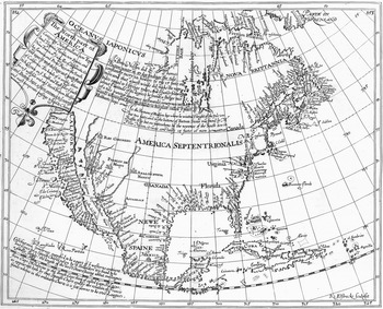
Henry Briggs's map of North America as it appeared in Samuel Purchas, Hakluytus Posthumus, or Purchas His Pilgrimes, 1625. Reproduced by permission of The Huntington Library, San Marino, California.

Brigg's well-known map of North America (fig. 10).Footnote 80 Briggs was a mathematician who was a professor at Cambridge and Oxford from 1592 to 1630. It is not surprising, therefore, that his map was more accurate than many of those that preceded it. It is important to note that Brigg's map is possibly the first English printed map of all of North America, before which, as we have seen, maps were centered on individual settlements or, at most, small portions of the Atlantic seaboard north of Florida. As such, this map is an indication that the policy of secrecy (at least about North America), which appears to have prevailed into the 1620s, was no longer relevant, likely because the increase in cartographical knowledge in the early seventeenth century meant the information it contained was much better known. Briggs terms the northern regions “Nova Brittannia,” which includes the English territories (with English toponyms) in the North Atlantic: Greenland, the Davis and Hudson Straits, and “Hudson's” and “Button's” Bays, the latter two named by Briggs himself.Footnote 81 As on Mason's map, in cartouches Briggs identifies that many of these regions had been recently entered and charted for England by Henry Hudson (1609–10), Thomas Button (1612), and William Baffin (1615). The French territories in “Canada,” the English territories in Newfoundland, New England, and Virginia, and the Spanish territories in Florida, California, the West Indies, and “New Spain” (Mexico) are shown in detail. Many of Briggs's ideas about North America, and in particular his place-names and division of the territory among the three primary colonizing powers, were used in John Speed's exceptionally popular map of North America that appeared in his Prospect of the Most Famous Parts of the World (1627).
Conclusion
Early manuscript and printed English maps of North America served a number of vital roles for English and European audiences. The skill and knowledge evident in the manuscript maps drawn by men such as Dee, Tindall, Raleigh, and White reflected the European approach to the cartographical revolution. These maps were detailed enough to inform sea captains of North American hydrography and to inform the English crown both of the New World's potential for colonization and of the territorial limits (and limitations) of its empire. The existence of so many high-quality manuscript maps suggests that English printed representations of the New World were not the result of inferior expertise, but rather the desires of the crown and the mapmakers to convey certain expressions of sovereignty without revealing secret information. In the printed maps, cartographical knowledge was subordinated to other concerns, through which the crown and its representatives, by employing censorship and patronage, could communicate the territorial limits and alleged permanence of its young empire both to subjects and to continental Europe. National and semiotic devices, such as the English jack, descriptive cartouches, coats of arms, Anglicized toponyms, images of armed ships in the water and fortifications on the mainland to show navigational knowledge and the ability to exert force, together had the effect of assisting the crown in asserting its often tenuous overseas claims. As these documents became increasingly distributed and copied, the semiotic devices they contained were copied into other maps and atlases of the period, where they gave the impression of English control over these regions. We cannot establish with any certainty precisely who saw these printed maps or what impact they might have had as expressions of sovereignty. Their repeated printings, often in multiple languages, and their continental distribution suggest that the messages they relayed improved Europeans' awareness of England's claims. To be sure, these maps did not solve the supranational disputes regarding imperium and dominium. They do show, at least, that the English were concerned about, and conforming to, the jus gentium regarding the modes of acquiring territory. This forces a reconsideration of some historians' claims that England used indigenous property laws and particularly mundane methods, such as planting gardens, erecting fences, and building houses, when establishing sovereignty in newfound lands.Footnote 82
The early printed maps of North America and the public's insatiable appetite for them also suggest something about the nature of nationhood and empire in the late sixteenth and early seventeenth century. Recent writers have explicitly denied that there was an ideological, political, or cultural “empire” during this period. Instead, overseas enterprises before about 1680 are usually depicted as being commercial enterprises, devoid of crown interest and involvement and lacking the later rhetoric of empire.Footnote 83 In many respects, this interpretation is correct. Yet, collectively, the printed maps paint a somewhat different picture. Even allowing that the maps were drawn for patrons who had close ties to the English crown, and therefore that a propagandist message would be attached to these representations, there emerges a picture of territorial unity: the regions depicted and made distinctly English on the maps were united by a common cultural, ideological, and political body. These maps did not contain the seal of the respective trading companies. They did not proclaim Virginia as a territory of the Virginia Company, nor Newfoundland of the Newfoundland Company. They did not elide the authority or involvement of the English crown in overseas territories. Instead, they combined elements of a distinctly English nomenclature to show that the region was part of a powerful, growing empire. That these devices made the empire (and, by extension, the English nation) appear even stronger than it in fact was is attributable to the success of the mapmakers in conveying a message much desired by their sovereign monarch. The maps were expressions of sovereignty and, as such, fully acknowledged the sovereign authority under which they were developed.