

The string of islands and islets that make up the Molène archipelago, in the Iroise Sea in western Brittany (Fig. 1), formed the peaks of a vast plateau that is today submerged under only a few metres of water. This plateau was attached to the continent during the period of low sea level which marked the last glacial maximum (c. 18,000calbp). With the rise in sea level during the Holocene, it was gradually insulated to form a single island, before splitting off into several islands and islets (Hallégouët Reference Hallégouët1982). Some of these geomorphological changes occurred in the presence of people, as demonstrated by the high concentration of monuments and archaeological structures on the current islands of the Molène archipelago, but also on the surrounding continental foreshores and inland areas. The fragmentation of the insular area had a number of consequences in terms of the accessibility of the islands, their isolation, the gradual reduction in land areas, the life-styles of local populations, resources, the understanding of the area, and exchanges and communication with the continent.
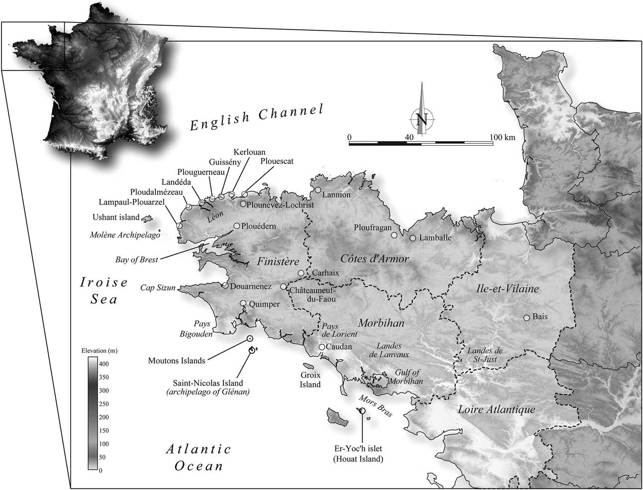
Location maps of the archeological sites and localities mentioned in the text

Within the framework of the Molène Archaeological Programme, a systematic survey of archaeological structures present on the islands of the archipelago has been conducted since 2001, in a bid to update the observations made successively by P. du Chatellier (Reference Chatellier1901), A. Devoir (archives CReAAH, UMR 6566), Giot & Hallégouët (Reference Giot and Hallégouët1980), and Le Goffic (Reference Le Goffic1994). Following this prospective phase, investigation of the structures and sampling of shell beds were implemented on the islands of Béniguet, Balanec, Lédénès Vihan de Quéménès, and Trielen. From 2003, excavations were conducted annually, following the discovery of a dry-stone building dated from the end of the 3rd millennium bc on the site of Beg ar Loued, at the southern tip of Molène Island. In addition to the archaeological excavations and surveys conducted, a meticulous study of the topography, monument architecture, and site stratigraphy, as well as in-depth analysis of artefacts (lithic and ceramic remains) and ecofacts (plant and animal remains) found on the sites was carried out by a multidisciplinary team.
The purpose of this article is to summarise the archaeological data by setting them against an initial analysis of the paleogeographic reconstruction of the archipelago. This work aims to define more accurately the area that was available to successive groups of humans from the Neolithic to the Bronze Age on the Molène plateau and to determine more precisely their lifestyle and economy. We will also attempt to understand how people managed or organised these areas: did they live there all year round or intermittently, for instance, seasonally? Did these islands have a particular significance for these populations who buried their dead there? Our goal is, therefore, to lay the first stone of a study which aims to model the daily living area of insular populations, by placing them within their environment.
GEOGRAPHY OF THE MOLÈNE ARCHIPELAGO
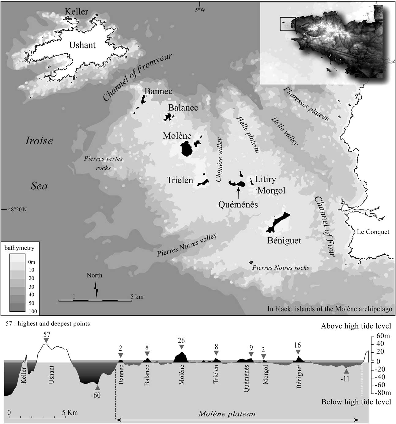
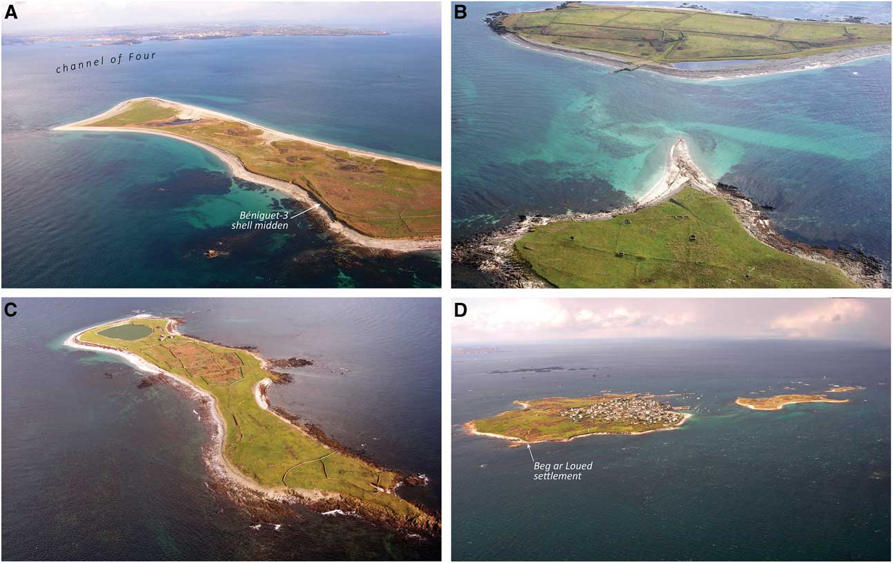
The Molène archipelago comprises nine main islands and islets: Bannec, Balanec, Molène, Trielen, Ile aux Chrétiens, Quéménès, Litiry, Morgol, and Béniguet, as well as nine secondary islets, generally known as lédénès and connected to main islands during low tide levels. In this area, the tidal range can reach up to 7.9m during spring tides. Apart from some scattered rocks, the elevation of these islands is limited to few metres above the highest water level which reaches 4.12m NGF (French Ordnance Datum) during high spring tide levels (Fig. 2). Molène Island is the highest with a peak of 26m NGF at the centre, while Béniguet has an altitude of 16m NGF in the south (Fig. 3).
Detailed map of the Molène archipelago

Aerial photographs of Molène archipelago. A. East part of Béniguet Island. B. Lédénès Vraz of Quéménès and Quéménès Island. C. Trielen Island. D. Molène Island (photos by L. Brigand & S. Le Berre)

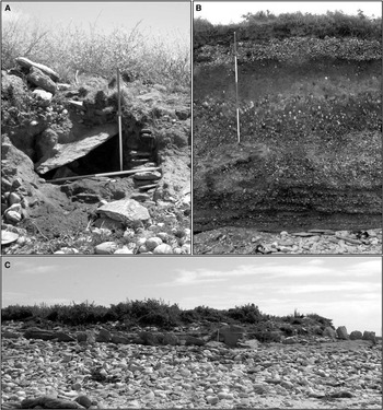
The Molène plateau lies in a south-east to north-west direction and is connected to the continent at Le Conquet by a narrow shelf 11m below the lowest water level. Everywhere else it is bordered by steep submarine slopes of structural origin, with a drop of 20–50m. Further offshore, Ushant Island is separated from this plateau by a deep rift known as the Channel of Fromveur (Fig. 2) which is 50–60m deep. During the last glacial maximum this plateau was connected to the continent as the sea level was around 120 m lower than it is today (Bassett et al. Reference Bassett, Milne, Mitrovica and Clark2005; Peltier Reference Peltier2004; Peltier & Fairbanks Reference Peltier and Fairbanks2006; Standford et al. 2011). We note that the Molène plateau is itself dotted with elongated depressions, caused by bands of softer rock or fractures (Chauris Reference Chauris1968). One of the largest of these depressions forms the Valley of la Chimère which cut the plateau in two, isolating the Helle plateau to the north-east (Fig. 2). During the Holocene the plateau was submerged by the sea level rise causing the flooding of its lowest areas (Hallégouët Reference Hallégouët1982). The particularly exposed nature of the archipelago to the heavy ocean swell generated in the North Atlantic probably promoted coastline retreat and erosion dynamics on the shoreline during the post-glacial transgression. These dynamics still continue today, in particular when extreme stormy events coincide with spring tides. The particularly violent storm that occurred on 10 March 2008 caused the coastline to retreat by 2–3m in places (Cariolet et al. Reference Cariolet, Costa, Caspar, Ardhuin, Magne and Goasguen2010; Fichaut & Suanez Reference Fichaut and Suanez2010; Suanez et al. Reference Suanez, Fichaut, Magne, Ardhuin, Corman, Stéphan and Cariolet2011). In the aftermath of this climatic event, many archaeological sites (Bronze Age stone cist, Middle Neolithic I long barrow, Neolithic shell midden) were uncovered (Gandois et al. Reference Gandois, Pailler, Stéphan and Nicolas2013) (Fig. 4).
Examples of archaeological remains eroded or discovered after the heavy storm of 10 March 2008. A. Bronze Age stone cist on Quéménès Island. B. Shell bed dated to the Late Neolithic in a cliff side (Béniguet-3 site). C. Double row of standing stones bordering a Middle Neolithic I long barrow discovered by erosion of the offshore bar located at the north part of Lédénès Vihan de Quéménès (photos by Y. Pailler)

PALAEOENVIRONMENTAL SETTING
Vegetated landscapes and the impact of human populations
Our knowledge of palaeoenvironments in western Brittany is restricted to few works (Van Zeist Reference Van Zeist1964; Morzadec-Kerfourn Reference Morzadec-Kerfourn1974; Giot Reference Giot1987; Marguerie Reference Marguerie1992; Reference Marguerie1995; Gaudin Reference Gaudin2004) which mainly focus on the evolution of the vegetation cover. Sediment samples have been taken from the passage graves on the islands of Carn (Ploudalmézeau, Finistère) and Guénioc (Landéda, Finistère), from the peat deposits located on the foreshores of the North Finistere, and from peat bogs located in the inner part of the west Brittany. These studies offer some palaeoenvironmental data for the Atlantic period (6500–4500bc) indicating a very wooded landscapes (80–100% of tree pollen in the pollen spectra) mainly composed of hazel, oak, lime, and elm, typical of the Early Holocene forests in this area (Gaudin Reference Gaudin2004). From the Late Mesolithic to the Early Neolithic, the proportion of hazel decreased gradually with the development of more dense and thermophile woodlands (ibid). The Subboreal period (4500–1900bc) is characterised by the development of oak woods in association with beech, replacing gradually the hazel. For the Middle Neolithic II (4300/4200–3500bc), pollen found in northern Finistère indicates that the local landscape had little woodland (Morzadec-Kerfourn Reference Morzadec-Kerfourn1974). The main types of trees were hazel, alder, and oak, with very herbaceous vegetation comprising many ruderal species indicating human settlement, which is confirmed by some cereal pollen (Marguerie in Giot Reference Giot1987). The pollen analysis conducted for the Curnic site (Guissény, Finistère) detected pollen that testified to a landscape made up of 40% woodland with, most commonly, hazel and birch, followed by lime and elm (Morzadec-Kerfourn Reference Morzadec-Kerfourn1974). Again, agricultural practices were identified. In the Late Neolithic, the results obtained on the Plouguerneau peat bog (Plouguerneau, Finistère) testify to land clearance and burning and indicate the presence of cereals (Morzadec-Kerfourn Reference Morzadec-Kerfourn1974).
The impact of human activities on the environment, which began in the Neolithic, intensified during the Bronze Age due to the development of agricultural practices and crafts (Marguerie Reference Marguerie1995; Gaudin Reference Gaudin2004; Daire et al. Reference Daire, Marguerite, Fily, Baudry, Quesnel and Arbousse-Bastide2011), even though there is evidence for some of these practices from the end of the Middle Neolithic. Cereal pollen, therefore, only appeared in the pollen spectra studied by Morzadec-Kerfourn (Reference Morzadec-Kerfourn1974) at the beginning of the Middle Bronze Age on the northern Finistère coastline. The beginning of crop farming coincided with major land clearing efforts and the gradual opening up of the natural environment.
HISTORY OF RELATIVE SEA LEVEL
The Holocene variations of relative sea level (RSL) have profoundly altered the coastal landscape in Brittany, especially in the shallow shelf of the Iroise sea. From the early to the mid-Holocene periods rates of RSL rise were very high (around 10 mm/yr) along the French Atlantic coasts (Lambeck Reference Lambeck1997). Ushant island was probably the first territory to be separated from the mainland, between 10,000 and 8000bc. The steep slopes delimiting the Molène plateau (Chauris Reference Chauris1968) show that it remained connected to the mainland and formed a large peninsula extending to the north-west until the last millenium of the Holocene period.
However, the chronology of palaeogeographic changes becomes more difficult to reconstruct from 6000–5000 bc, when the rates of RSL rise decrease to around 1 mm/yr (Standford et al. 2011) because of the regional variability of sea level history related to isostasy (Lambeck Reference Lambeck1997). In Brittany, most of sea level studies were undertaken in 1970s and 1980s (Delibrias & Morzadec-Kerfourn Reference Delibrias and Morzadec-Kerfourn1975; Van De Plassche Reference Van De Plassche1991) and present a lack of precision with regard to radiocarbon dates, sea level indicators used, errors in the elevation of sedimentary levels sampled, and their relation to actual tide levels.
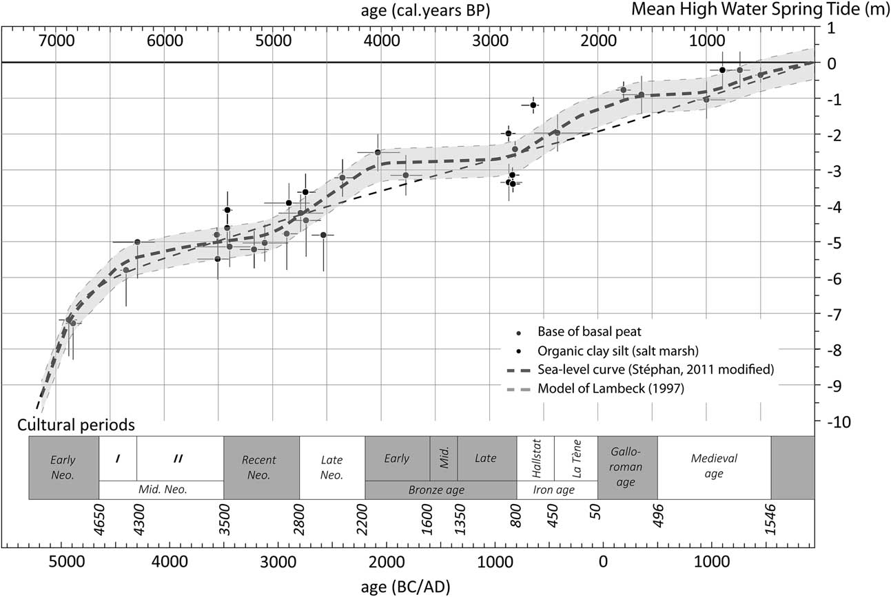
More recently, Stéphan (Reference Stéphan2011) studied three coastal sedimentary sequences of back-barrier salt-marshes of the bay of Brest. The position of RSL was defined with a mean precision of ±50 cm using a salt-marsh foraminifera-based transfer function. The sea level curve obtained shows a gradual deceleration of marine transgression, punctuated by 1500 year periodicity phases of RSL stability (Fig. 5) which could be related to rapid climate changes known as the Bond Cold events (Bond et al. Reference Bond, Showers, Cheseby, Lotti, Almasi, de Menocal, Priore, Cullen, Hajdas and Bonani1997). A relative stabilisation of RSL, around 5.5m below its current level, was recorded between 4500 and 3000bc and implied a seaward position of the coastline during the Middle and Late Neolithic. An acceleration of RSL rise is suspected during the Late Neolithic and Early and Middle Bronze Age, between 3000 and 1200bc, at a position 3–2.5m below its current level and flooding certain settlements, such as that of Curnic in Guissény, and coastal megalithic monuments such as the gallery grave of Lerret in Guissény or the Men Ozac’h standing stone in Plouguerneau (Sparfel & Pailler Reference Sparfel and Pailler2009). A relative stability in RSL is then believed to have occurred at the end of the Bronze Age, between 1200 and 800bc. This period corresponds with the formation of the large coastal dune complex in the north-western part of Brittany (Hallégouët Reference Hallégouët1978; Guilcher & Hallégouët Reference Guilcher and Hallégouët1991). These changes appear to be confirmed by the discovery of archaeological sites dated to the Bronze Age buried under the sand dunes (Giot Reference Giot1968; Reference Giot1970; Le Roux Reference Le Roux1971). Finally, sea level began to rise gradually once again from the Iron Age and continued at a decreasing rate to the present day.
Sea-level curve and sea-level points obtained by a salt-marsh foraminifera-based transfer function defined in the bay of Brest (modified of Stéphan et al. Reference Stéphan2011)

PALAEOGEOGRAPHIC CHANGES OF THE MOLÈNE ARCHIPELAGO
The palaeogeographic changes of the Molène archipelago from the Neolithic was reconstructed by simulation of the Holocene sea level rise defined by Stephan (2011) using a digital elevation model representing the recent topography and bathymetry of the Iroise Sea. The bathymetry of the archipelago was modelled using the Surfer 8.0 software based on measurements taken by the French Naval Hydrographic and Oceanographic Service (SHOM). The topography of the islands and certain islets (foreshore and terrestrial zones) was extracted from the French National Geographic Institute (IGN) topographical model (resolution 10 × 10m), then integrated into our digital elevation model. The absence of a sedimentary coastal wedge on the shelf allows this methodological approach because the underwater morphology is not masked by a cover of sedimentary deposits and reflects the palaeotopography of the coastal landscapes. However, the relevance of the palaeogeographic reconstructions obtained remains limited. The retroactive phenomena related to coastal morphological changes (from sea bed erosion to coastal sediment accumulation) have not been taken into account. Moreover, the simulations draw upon a ‘passive submersion’ model while the reality is far more complex. Consequently, the maps produced by this simulation should be considered as a first approximation.
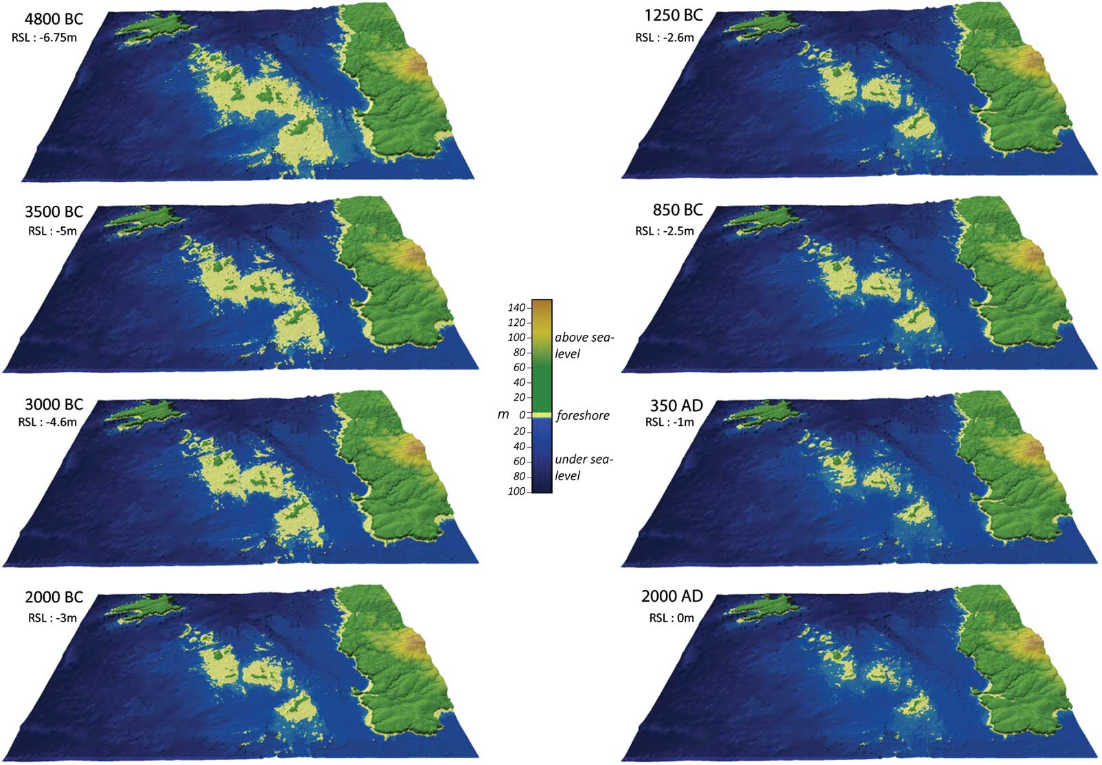
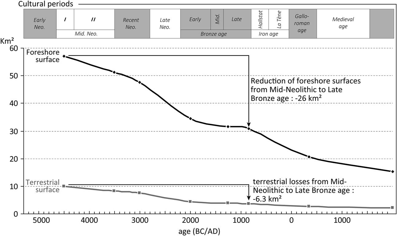
Around 4800 bc, ie, the Early Neolithic, the Molène plateau was already formed of a string of islands and islets, separated from the continent by the Channel of Four, whose minimum depth at lowest tide was as little as 5–6 m (Fig. 6A). Boats were necessary at that time for the island populations to travel to and from the continent. At the beginning of Middle Neolithic II all the islands were still linked together during the lowest tide levels, except for Bannec. The total surface area of the archipelago at low tide reached 67km2, compared to only 17 km2 today (Fig. 7). The foreshore surfaces reached 57 km2 and offered a high potential in terms of food resources based on fishing and shellfish and crustacean harvesting. Although it is difficult to reconstruct accurately the palaeotopography from current topobathymetric data, it seems that all the secondary islets, or lédénès, today insularised, were also linked to main islands by dry land. This configuration was maintained for over a millennium, until the Late Neolithic (c. 3000 bc), in a context of relative stability of the sea level (Fig. 5).
Sequences of Paleogeographic changes of the Molène archipelago from 4800 bc to present

Evolution of the surface area of the foreshore and emerged islands in the Molène archipelago from 4300 bc to the present day

After this date, a transgressive movement began, gradually isolating five geographical entities, during the Early Bronze Age (c. 2000 bc): Bannec, Balanec, Molène-Trielen, Quéménès-Litiry-Morgol, and Béniguet (Fig. 6). Even during spring tides, at low tide these five areas of land were separated by 500–1500m-wide shallow channels, through which strong tidal currents probably flowed. The erosive dynamics which accompanied this gradual rise in sea level resulted in the reduction of the islands’ surface areas and, for some, their fragmentation. It was probably during this period that certain lédénès formed, such as Molène and Quéménès, which could then only be accessed by foot at low tide. This evolution continued until the Middle Bronze Age (c. 1250 bc) and the isolation of the different insular entities was gradually accentuated. The channels separating them widened and deepened. Nevertheless, in parallel to this general trend of erosion, constructive dynamics are likely also to have occurred, resulting in the creation of sediment accumulations behind topographic obstacles, as shown today by the many trailing spits and tombolos found in the archipelago (Guilcher Reference Guilcher1959; Hallégouët Reference Hallégouët1982; Suanez et al. Reference Suanez, Fichaut, Magne, Ardhuin, Corman, Stéphan and Cariolet2011). These dynamics may, in some cases, have led to the temporary growth of islands. The foreshore surface losses related to marine transgression are estimated at 26 km2 from the Middle Neolithic to the Late Bronze Age (Fig. 7).
The Bond Cold event 2 (Bond et al. Reference Bond, Showers, Cheseby, Lotti, Almasi, de Menocal, Priore, Cullen, Hajdas and Bonani1997), which is believed to have marked the end of the Bronze Age (c. 850 bc), may have temporarily agravated the erosion and insular fragmentation processes because of higher storminess in Brittany (Sorrel et al. Reference Sorrel, Tessier, Demory, Delsinne and Mouaze2009; Reference Sorrel, Tessier, Demory, Baltzer, Bouaouina, Proust, Menier and Traini2010; Tessier et al. Reference Tessier, Billeaud, Sorrel, Delsinne and Lesueur2012). This period is also considered to be a major phase of coastal dune accumulation (Giot Reference Giot1970; Guilcher & Hallégouët Reference Guilcher and Hallégouët1991) and it is very probably at this time that the sand which is found in the islands’ soil was supplied. A few settlements or funerary monuments were no doubt buried under larger supplies of sand. This was the case for some archaeological structures found in the dunes of northern Finistère and Morbihan, such as at Beg ar Loued (Pailler et al. Reference Pailler, Gandois, Ihuel, Nicolas and Sparfel2010) and Port-Mélitte (Groix island, Morbihan; Le Roux Reference Le Roux1971). Finally, from 850 bc, the transgressive movement resumed and ended up carving the archipelago to give it the geographical configuration we know today.
ARCHAEOLOGICAL DATA COLLECTION
An innovative geoarchaeological approach
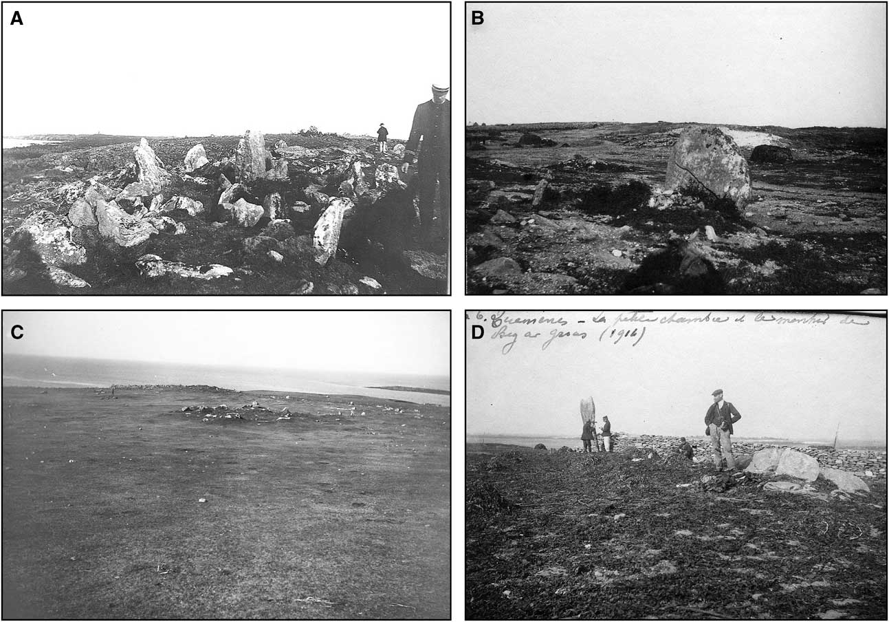
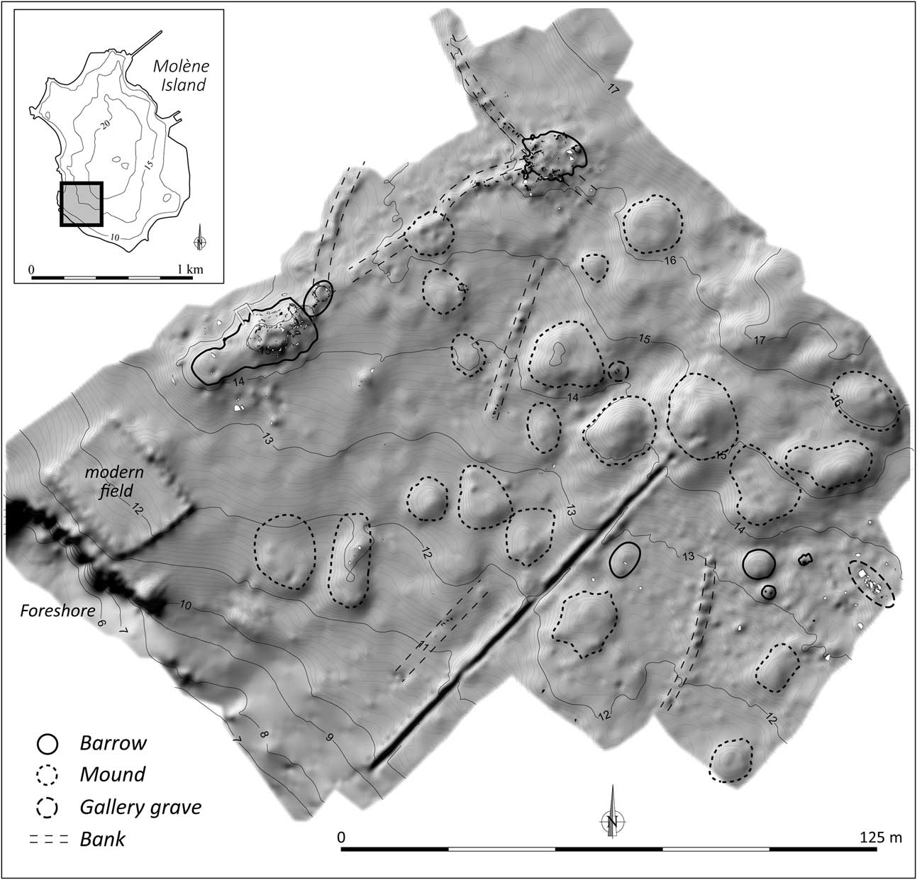
The primary aim of the geoarchaeological approach adopted in this study was to update the inventory of archaeological remains conducted from the beginning of the 20th century by du Chatelier (Reference Chatellier1901) and Devoir (Hervé Reference Hervé1900) in the Molène archipelago. During this period, the identification of the main megalithic monuments was made easier as these islands were widely cultivated (Arzel Reference Arzel1987) and offered vast surface areas that were either bare or covered with short vegetation, as shown in the photographs taken during these initial field trips (Fig. 8). However, this initial inventory remained mainly descriptive (Sparfel & Pailler Reference Sparfel and Pailler2009) and, with the exception of a few partial observations made between the 1970s and 1990s (Giot & Hallégouët Reference Giot and Hallégouët1980; Le Goffic Reference Le Goffic1994), no exhaustive geoarchaeological study has been conducted to date on the entire archipelago. The work undertaken over the past years has been attempted to overcome this lack of data, in order to enhance the inventory and, moreover, to locate accurately all the Neolithic and proto-historic archaeological sites present on the different islets of the archipelago. All the remains identified at the surface (located on Fig. 9) were systematically recorded, combining classic drawing methods with topographical recordings taken using a differential GPS. Topographical measurements were taken using the Lambert I coordinate system and connected to the NGF-IGN 69 system from different geodetic control points located on the islands of Molène and Quéménès. These recordings enabled digital elevation models (DEM) of archaeological structures and their immediate environment to be produced (Fig. 10).
The environment of megalithic monuments at the beginning of the 20th century. A. Megalithic grave at the western point of Trielen Island, view from the west. B. Stone cist and bedside slab of a long barrow on Trielen. C. North part of Zoulierou necropolis on Molène Island, view from the north-east. D. Ruined dolmens and standing stone at Beg ar Groaz point on Quéménès Island (photos by A. Devoir, CReAAH archives, UMR 6566)

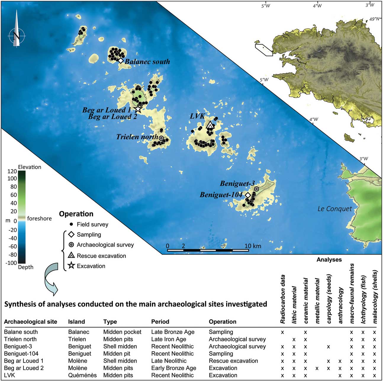
Location of archaeological remains and types of operation conducted on the islands of the Molène archipelago. The table presents the details of analyses on the main archaeological sites investigated

Digital elevation model of Zoulierou necropolis on Molène Island

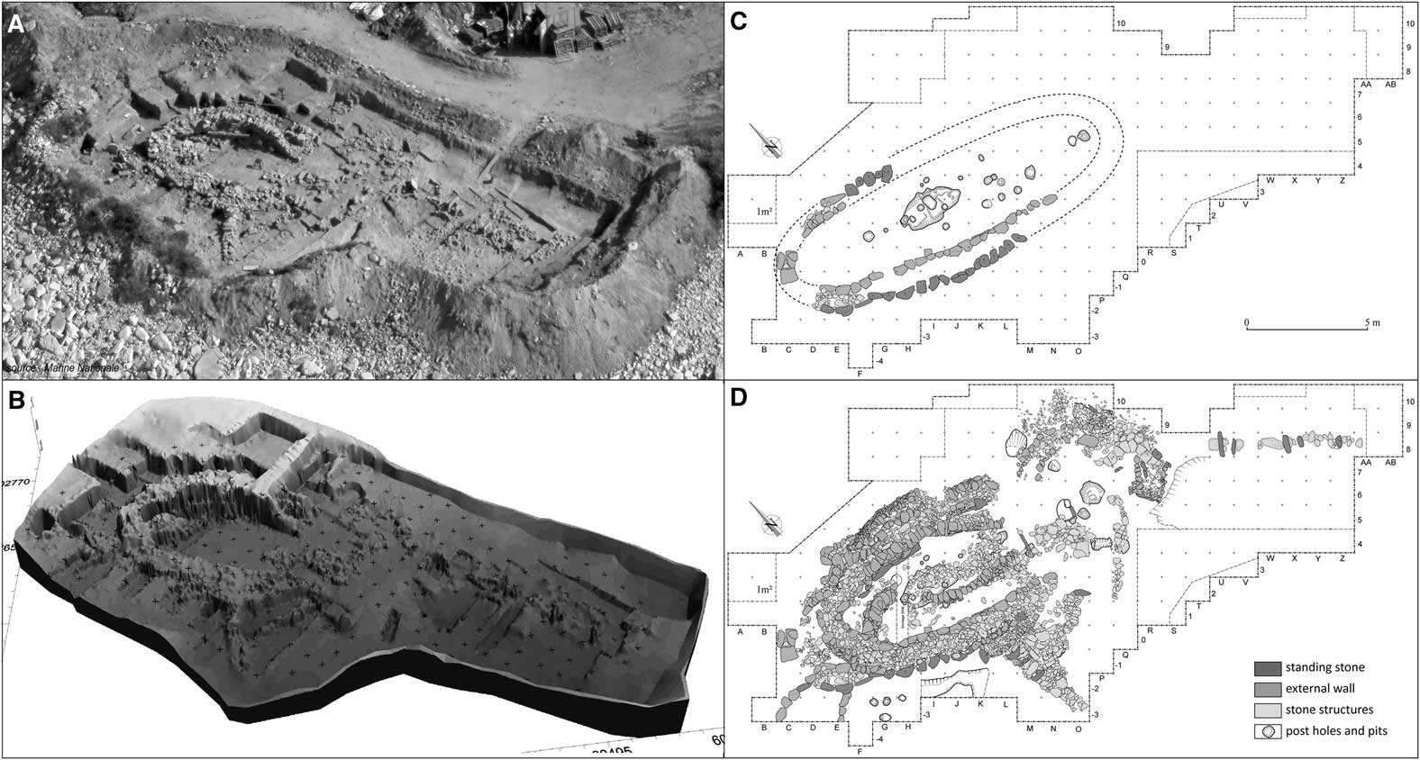
The second aim of our geoarchaeological approach was to place the archaeological site of Beg ar Loued within its palaeogeographic context. Since 2002 a major programme of excavations has been being carried out on this site, located south of Molène Island, on the basis of its occupation from 2700–2600 to 1800 bc, the Late Neolithic and Early Bronze Age. The occupation period of this site is well known thanks to 29 radiocarbon dates obtained on wood and bones fragments and calibrated on Calib Rev 5.1 beta (© 1986–2006 M. Stuiver & P. J. Reimer) software using the IntCal04 calibration curve (Reimer et al. Reference Reimer, Baillie, Bard, Bayliss, Beck, Bertrand, Blackwell, Buck, Burr, Cutler, Damon, Edwards, Fairbanks, Friedrich, Guilderson, Hogg, Hughen, Kromer, McCromac, Manning, Ramsey, Reimer, Remmele, Southon, Stuiver, Talamo, Taylor, Plicht and van der & Weyhenmeyer2004). Through the successive excavation campaigns, an oval-shaped building, possibly a circular house, along with many related structures and several middens have been fully excavated (Pailler et al. Reference Pailler, Sparfel, Tresset, Dupont, Giovannacci, Hallégouët, Josselin, Balasse and Marchand2004a; Reference Pailler, Sparfel, Tresset, Dréano, Dupont, Giovannacci and Josselin2004b; Reference Pailler, Gandois, Ihuel, Nicolas and Sparfel2010; Fig. 11). These structures were well conserved largely due to the fact that they became buried under a sand dune after the site was abandoned.
The site of Beg ar Loued (Molène Island). A. Aerial photograph during excavation in 2009 (by courtesy of the French Navy). B. Digital elevation model (produced by Géomer – UMR 6554, June 2009). C. Detailed plan of archaeological structures of the Late Beaker/Early Bronze Age, first state of the house (drawing by C. Nicolas). D. Detailed plan of archaeological structures of the Early Bronze Age, final state of the settlement (drawing by C. Nicolas)

In parallel with this work, several surveys and samples were taken specifically from the archipelago’s shell middens, as in these deposits organic remains are generally very well preserved (Fig. 9 for location). Two shell middens uncovered following winter storms and dated to the Late Neolithic were studied on Béniguet Island (Béniguet-3 & Béniguet-104; Fig. 3A & Fig. 4B). On Lédénès Vihan de Quéménès, a midden, also from the recent/Late Neolithic, was dated to c. 3000 bc. A pocket midden in Balanec – belonging to the Late Bronze Age – was also investigated. In the northern part of Quéménès Island, a Bronze Age stone cist which appeared in the side of a cliff was investigated, as well as a trapezoid-shaped long barrow from the Middle Neolithic I in the north of Lédénès Vihan de Quéménès Island. Finally, in the northern part of Trielen Island, a salt-boiling house, attributed to the La Tène period (Second Iron Age), was investigated.
The contribution of environmental and cultural indicators to the geoarchaeological approach
The floral and faunal remains obtained from the archipelago’s different archaeological sites constitute primary palaeoenvironmental indicators. An initial image of the vegetation was obtained by studying 1120 charcoal samples collected during the various excavations (details in Fig. 9). Meanwhile, a carpological study of a corpus of 420 cereal seeds collected from sites Béniguet-3 (N=60) and Beg ar Loued (N=360) also provided a more accurate vision of the farming practices in the archipelago in the Neolithic and Early Bronze Age.
The abundance of faunal remains, whether marine fauna (marine fish, mammals, and molluscs, crustaceans, echinoderms) or terrestrial fauna (mammals, birds), also provided representative insights into the diet and methods of resource use of these insular populations. Breeding practices could therefore be reconstructed through the presence of domestic mammal remains among the faunal species identified. The many skeletal remains of ichthyofauna more specifically provided new data on fishing techniques and strategies of Neolithic groups, as well as the dynamics of certain fish populations. As part of this work, almost 5800 fish skeletal remains were specifically identified (Dréano in Pailler et al. Reference Pailler, Gandois, Tresset, Baillon, Bourgarit, Boury, Callou, Cariolet, Carrion, Chambon, Darboux, David, Debue, Donnart, Dreano, Fichaut, Goslin, Gueret, Gonidec, Le Clezio, Le Gall, Marcoux, Marguerie, Mayer, Nicolas, Pineau, Salanova, Sellami, Staub, Stéphan, Suanez and Troalen2009b), making it a reference for late prehistory on the scale of the French Atlantic coast. Recognition of the different species of marine molluscs, crustaceans, and echinoderms contained within the shell middens provided information on the type of tidal and infra-tidal environments associated with them. The comparison of past collections of faunal species with their current equivalents highlighted any environmental changes in the coastal environment. To date, 48,000 shell fragments have been identified, contributing to better knowledge not only of the species used by people but also indirectly of the environments present in the archipelago during the time of their collection.
Finally, the study of stone, ceramic, and, to a lesser extent, metal industries on the different archaeological sites of the Molène archipelago provided insight into the cultural links between the islands and the continent, mainly by providing information on the use of raw materials. In this respect, the quantity of information obtained on the Beg ar Loued site alone is exceptional. In total, 162,000 lithic items underwent typological and technological analysis as well as an experimental approach, through which the lithic use-strategies of the inhabitants of Beg ar Loued could be seen (procurement of raw materials, production, and use of tools; Donnart et al. Reference Donnart, Naudinot and Le Clézio2009). On this same site, an initial typological classification of ceramics was obtained, with a chronocultural attribution from 36,700 sherds.
FREQUENTATION AND OCCUPATION OF THE ARCHIPELAGO
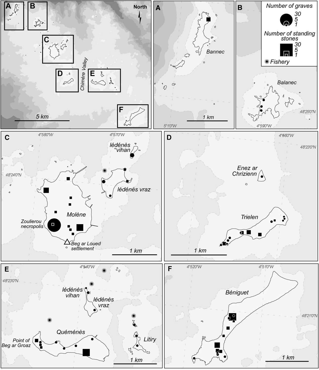
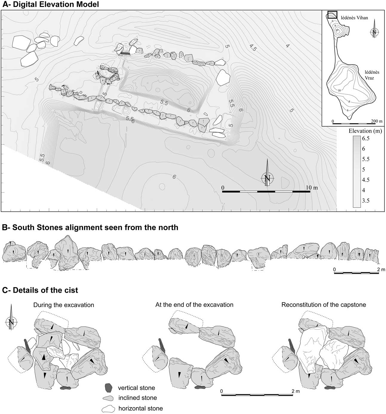
The profusion of archaeological remains makes the Molène archipelago one of the richest sites in western Brittany, especially for megalithic monuments (Sparfel & Pailler Reference Sparfel and Pailler2009; Fig. 12). The preservation of Neolithic graves has been shown to be rather variable according to the location, depending mainly on the human activities that have occurred around the monuments during the 19th and 20th centuries. Generally speaking, the absence of mechanised farming on most of these islands mitigated damage, compared to the continent where many megaliths were destroyed during land reparcelling. These monuments show various architectures, some of which are little known, or even unseen, elsewhere in northern Finistère. This is the case, for instance, for the monument located at the northern tip of Lédénès Vihan de Quéménès, where the excavation uncovered a trapezoid-shaped long barrow, 20 m long by 5–6.5 m wide. A megalithic stone cist, with an opening to the west, is apparent on the western side. From an architectural point of view, the monument is bordered on each long side by a line of foliated gneiss standing stones 1–2 m high (Fig. 13).
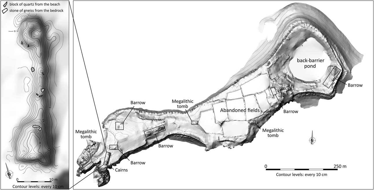
Distribution map of the Neolithic or Bronze Age graves (round and long barrows, cairns, stone cists, etc), standing stones and fisheries known of in the Molène archipelago

Trapezoidal long barrow with stone cist on Lédénès Vihan de Quéménès (map produced by C. Nicolas, Y. Sparfel & P. Stéphan)

In the absence of systematic excavations, putting an age on most archaeological remains is often a delicate task. For the graves in the Molène archipelago it may be suggested that the variety of monuments reflects varied cultural practices and, therefore, different periods, starting from the middle of the 5th and extending through the 4th, 3rd, and 2nd millennia bc. Currently, the majority of chronological indicators are based on analogies with monuments having undergone excavation in the region. The most common Neolithic graves in this area of Finistère are passage graves, believed to be constructed between 4300 and 3800 bc. These graves are present on nearly all the islands along the Finistère coast from Lampaul-Plouarzel to Landéda (Giot Reference Giot1987; Sparfel & Pailler Reference Sparfel and Pailler2009). In the Molène archipelago, several monuments can be attributed to this architectural category, the most obvious cases being the tombs contained within the tumulus No. 186 on Trielen Island or that of Beg ar Groaz (No. 170) on Quéménès (Sparfel & Pailler Reference Sparfel and Pailler2004). Other monuments could be classified as Late Neolithic gallery graves, as is the case of the monument which is today destroyed on Béniguet and another very ruined example on the east side of Zoulierou necropolis on Molène Island (Sparfel & Pailler Reference Sparfel and Pailler2004). Several small cist monuments were quite easily inserted into the group of individual tombs known from the Early Bronze Age: some, such as those discovered at Zoulierou, are rectangular and composed of four regular slabs forming the sides and covered with a 5th, while others, such as that attacked by marine erosion north of Quéménès farm, are composed of megalithic slabs and rubble walls (Fig. 4A).
Megalithic grave location and distribution strategies
Today, the Quéménès long barrow is located on the lower part of the islet, at the current high tide limit (around 5.5 m NGF) but, in the Neolithic, was located on a crest line and must therefore have been easily seen. As for the islands closest to the continent, the builders on the island chose to build passage graves – and those that we suspect belong to this family – on low hills, but sufficiently prominent in relation to their surroundings. The grave distribution appears to be determined by different factors which were governed by cultural choices – for instance, the majority of passage grave entrances were open to the east – and natural constraints such as the topography (monument visibility) and lithology (stone availability). On Trielen Island, the monuments are distributed along the island’s crest line, from the western tip to the edges of the back-barrier pond (Fig. 14). Only the area occupied by modern farmland is free of megalithic sites. In Béniguet, megalithic monuments are mainly concentrated around two high points, in the centre and south of the island respectively (Dréano et al. Reference Dréano, Giovannacci, Dupont, Gruet, Hoguin, Ihuel, Leroy, Marchand, Pailler, Sparfel and Tresset2007). This distribution is also respected on Quéménès Island where the funerary monuments are concentrated around the high points of the western tip of Beg ar Groaz. Only the islands of Balanec and Bannec are exceptions to this rule. They each have two barrows and three ruined dolmens. This relatively low concentration of megalithic remains on these two islets could be due to their distinctive topographic configuration. If groups built their graves to overlook their land, perhaps the limited size of the coastal plain around the hills during the Neolithic did not allow many communities to settle there. The islands with the highest concentration of megaliths, on the other hand, were surrounded by larger areas probably allowing the development of farming.
Distribution map of the megalithic monuments on Trielen Island and detail of two cairns joined by an embankment

Another explanation for the low concentration of megalithic remains on the islands of Balanec and Bannec is provided by palaeogeographic data. From the Middle Neolithic, these islands were isolated from the rest of the Molène archipelago and were already full-fledged insular entities which were difficult to access and therefore less frequented by human populations.
Geographical isolation versus cultural isolation
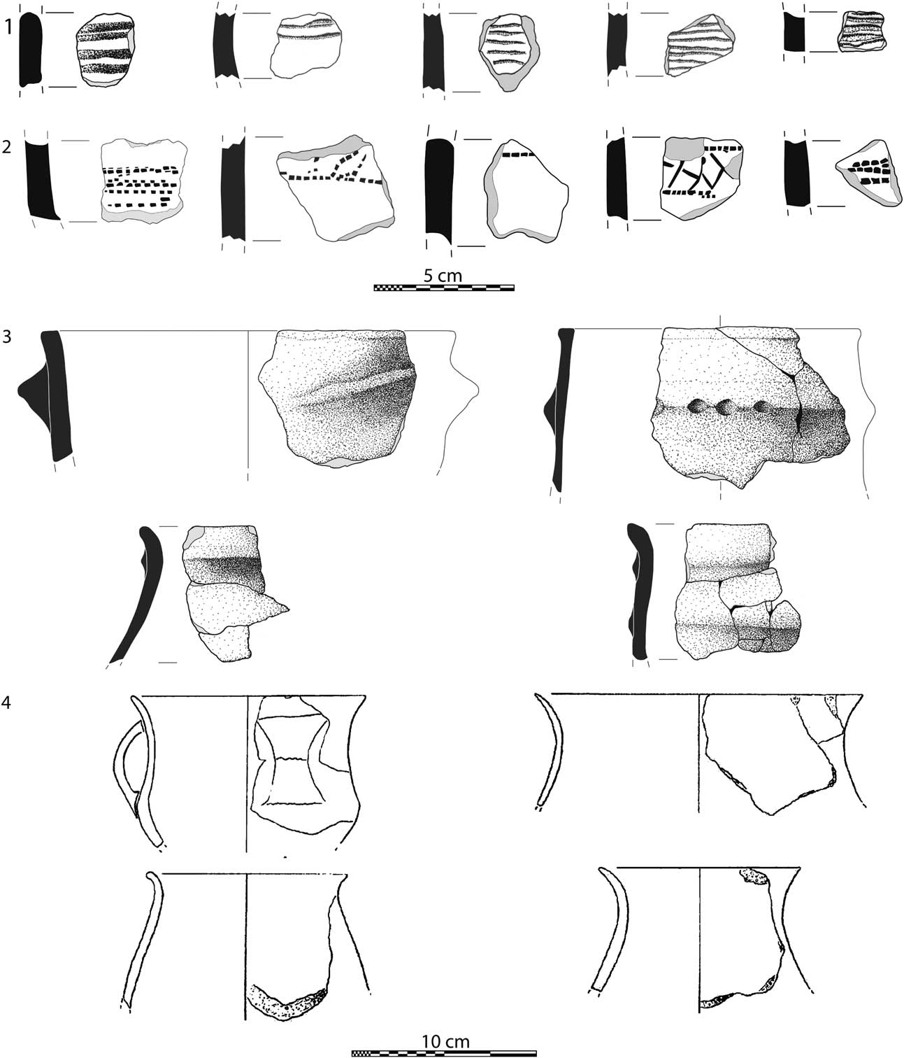
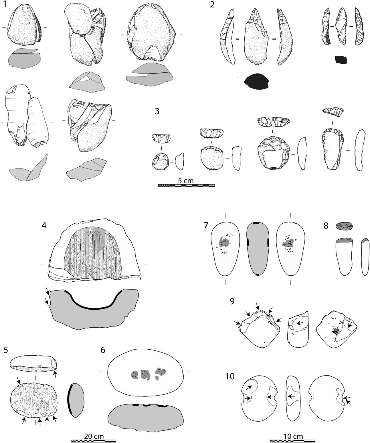
In the Molène archipelago, the geographical isolation and growing remoteness of the islands from the continent do not appear to have resulted in marked cultural particularities. Although the islands have become increasingly less accessible and exchanges with neighbouring mainland societies rarer, resulting in tools being made almost exclusively from local raw materials, most technical innovations from the Neolithic and Bronze Age are found on the archipelago’s archaeological sites, attesting to continuous cultural exchanges between insular societies and their continental neighbours. A few fibrolite polished blades found on the Beg ar Loued site come from the mainland. The raw material of which these Kermorvan or Plouguin-style fibrolites are made indicates that they were from the Léon area of Brittany (Pailler Reference Pailler2009). Similarly, analysis of the ceramic artefacts found at Beg ar Loued confirmed the presence of a Late Neolithic style (Conguel), Bell-Beaker pottery, represented by decorated beakers and common pottery (Salanova Reference Salanova2000), as well as cordoned urns and handled jugs, which are typical of the Early Bronze Age (Fig. 15). These pottery styles represent a chronological sequence which remains poorly identified in the northern half of France; it is between the end of the 3rd and the beginning of the 2nd millennium bc, ie, the Neolithic–metal age transition. The lithic material shows a supply which is exclusively local and, for the most part, made on the shore (flint and Armorican sandstone pebbles). The main part of the debitage has been obtained by split technology. Flint tools are quite monotonous with a predominance of drills during late Neolithic and scrapers during Early Bronze Age. A very important corpus of coarse stone tools has been collected: among the most representative are anvils and hammers for split technology, grinding stones, beveled pebbles, and chopping-tools (Fig. 16). Few points of comparison exist due to the lack of excavated Early Bronze Age settlements on the continent; nonetheless a parallel can be made with the finds discovered in material mounds of numerous barrows (Briard Reference Briard1984) and also with some grave goods from, for example, Kerougant graves (Plounévez-Lochrist, Finistère; du Chatellier Reference Chatellier1882).
Selected Late Neolithic, Bell Beaker, and Early Bronze Age pottery from Beg ar Loued. 1. Decorated Conguel sherds; 2. Decorated Bell Beaker sherds; 3. Cordoned urns; 4. Handled jug and fine pots (Nos 1–3, drawings by S. Giovannacci; No. 4 drawing by L. Salanova)

Lithic tools from Beg ar Loued. 1. Deposit of flint flakes obtained by split technology; 2. Flint drill; 3. Flint scraper; 4. Grinding stone made of granite; 5. Handstone made of granite; 6. Anvil made of Armorican sandstone; 7. Hammer made of Armorican sandstone; 8. Beveled pebble made of Armorican sandstone; 9. Chopping-tool and abrading stone made of Armorican sandstone; 10. Notched pebble made of granite (No. 1, drawings by A. Pineau; Nos 2 & 3, drawings by L. Le Clézio; Nos 4–10, drawings by K. Donnart)

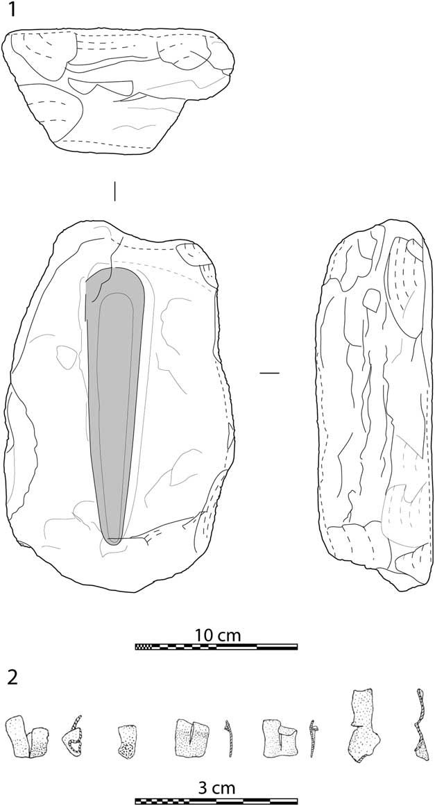
The discovery of a granite mould, waste containing copper inclusions, and five small broken objects made of sheet copper or copper alloy during the excavations at Beg ar Loued constitute intriguing evidence of metal-working activities, which is extremely rare in northern Finistère in the Early Bronze Age (Fig. 17). Similar sheet copper artefacts have been found in Beaker contexts in England: for instance, grave 919 at Barrow Hills, Radley, Oxfordshire (Barclay & Halpin Reference Barclay and Halpin1999) and a grave at Beggar’s Haven, Poynings, East Sussex (Kinnes Reference Kinnes1985).
Metal working tool and metalwork. 1. Granite bar mould; 2. Sheet copper artefacts (No. 1, drawing by C. Nicolas; No 2, drawings by H. Gandois)

Finally, in terms of its shape and construction method, the building uncovered at Beg ar Loued is unique in western France, but shows interesting analogies with several Bell-Beaker buildings scattered from Portugal to the Scottish Hebrides (Pailler et al. Reference Pailler, Gandois, Ihuel, Nicolas and Sparfel2010).
AGRO-PASTORAL PRACTICES, LANDSCAPE DYNAMICS, & PROMOTION OF INSULAR TERRITORIES
Cereal farming in the archipelago from the beginning of the Late Neolithic is attested by the presence of cereal caryopses found in the layer subjacent to the Béniguet-3 shell midden (Dréano et al. Reference Dréano, Giovannacci, Dupont, Gruet, Hoguin, Ihuel, Leroy, Marchand, Pailler, Sparfel and Tresset2007), some 20 or so of which were attributed to soft (bread) wheat (Triticum aestivum). One of these caryopses was dated to 4665±35 bp (Lyon-6231; SacA 16645), ie, 3530–3365 cal bc. Similarly, on the Beg ar Loued site, carpological analyses conducted on the plant macro-remains identified 11 taxa. Six are cultivated plants, including four cereals (hulled and naked barley, emmer, and wheat) and two pulses (fava bean and pea). A crop weed, the wild radish, is also present on the site, as well as three wild fruit trees, probably linked to a gathering activity (hazel, common hawthorn, and common dogwood). While hazel is omnipresent on Neolithic sites, incidences of hawthorn are less frequent as they occur at only 18.4% of sites studied (Dietsch-Sellami Reference Dietsch-Sellami2007). Dogwood drupes are not very well known for their nutritional value (Foinard Reference Foinard1958; Lieutaghi Reference Lieutaghi2004) even if, once cooked, they are sometimes considered edible (Couplan Reference Couplan1990). However, they are well known for their oil, which was once used as lamp oil (Bonnier 1911–Reference Bonnier34; Foinard Reference Foinard1958): the pulp and stone contain a high content (20–50%) of foul-smelling oil that is good for burning (Lieutaghi Reference Lieutaghi2004). At Beg ar Loued, the grinding tools discovered also indicate domestic activities associated with cereal crops in the Late Neolithic, as indicated by the presence of many grinding stones and mullers which, when broken, were reused as construction materials in the walls of Bell-Beaker houses. Furthermore, the results obtained at Béniguet-3 indicate a lower proportion of barley seeds than wheat seeds, which require deep, rich soils. This begs the question of whether this difference is not simply related to the quality of the available land, which is more conducive to demanding crops on Béniguet than Molène. These agronomic differences are still perceptible in the agricultural use made of these islands until the last century (du Chatellier Reference Chatellier1901; Brigand Reference Brigand2002; Darcques-Tassin Reference Darcques-Tassin2005).
In addition to arable, there is evidence of livestock farming from the Late Neolithic/Chalcolithic. Remains of domestic mammals – cattle, pigs, sheep, and perhaps goats – were discovered in the midden on Ledenez Vihan de Quéménès, as well as at Beg ar Loued on Molène. At the latter site, the presence of all age categories, of partly articulated skeletons, as well as deciduous teeth, clearly pleads in favour of their farming on the island itself, at least as far as sheep are concerned, which are well represented among the finds.
The analyses conducted on the floral remains found on the Beg ar Loued site provide a partial image of the plant cover of the archipelago during the Late Neolithic. The results of charcoal analysis show a great taxonomic wealth: 17 taxons were observed. Broom/gorse and oak are the main types, along with many fruit trees (Maloideae such as pear, apple, and Sorbus species, and Amygdaloideae such as cherry and blackthorn), and hazel. The variety of woods listed is quite typical of Neolithic oak forests in western Brittany with holly and yew (Gaudin Reference Gaudin2004; Marguerie Reference Marguerie1992; Morzadec-Kerfourn Reference Morzadec-Kerfourn1974) mixed with a coastal landscape of broom/gorse and fruit trees. The wood fragments are mainly large in diameter (>20 cm) and the oaks (sessile and/or pedunculate) have a relatively limited annual radial growth rate. Two taxa appear to be exceptional in this area during this period: walnut and maritime pine. This charcoal dataset raises the question of the presence of trees and shrubs on Molène Island at the end of the Neolithic. The species composition reflects more a tree covered area than isolated individual specimens and, therefore, suggests the maintenance of wooded areas in the form of the vestiges of forests, woods or tree-covered embankments.
The settlements at Béniguet-3, Béniguet-104, Beg ar Loued, and Lédénès Vihan de Quéménès date from a period which extends from the Late Neolithic to the Early Bronze Age and which coincides with a phase of individualisation of the archipelago’s different insular units (Fig. 6). We can, therefore, envisage the presence of several agro-pastoral communities, which may have been more or less inter-dependent and have used the islands’ land for crop or livestock farming. The size of these communities is difficult to estimate, but suppositions may be made on the basis of the volume of the shell middens discovered to date and which, as rubbish mounds, are perhaps representative of the population size and/or the duration of human occupation of the different insular units. In this way, the size of midden at Béniguet-3 testifies to a relatively large population, which may have been maintained by the high agronomic potential of this area. However, the duration of occupation would seem to be rather short (perhaps only a few years), as indicated by the absence of pedogenesis in the constitution of this deposit. The islands of Quéménès, Litiry, and Morgol also appear to have been densely occupied, due to the apparent volume of the midden excavated on Lédénès Vihan of Quéménès. Trielen Island, however, appears probably to have been devoted to the dead, a sort of necropolis island, as no middens dating from this period have been found to date, unless they were destroyed by marine erosion. The occupation of Molène is a well established fact thanks to data from the excavation of the Beg ar Loued settlement and to the many middens associated with it. Radiocarbon dates indicate continuous occupation for almost four centuries. Finally, the islands of Bannec and Balanec seem to have been occupied on an occasional basis. Examination of cliff edges has not revealed any large shell beds; only one pocket midden dated to the Late Bronze Age was identified. The study of its content did not present any evidence of crop or livestock farming, with the exception of one horse tooth derm.
These results emphasise the great diversity of modes of occupation, development, and management of the insular units of the Molène archipelago by Neolithic human communities. These communities seem to have prioritised the areas most conducive to crop and livestock farming. The presence of wooded areas, even in the form of residual lamina, also raises the question of the management of wood resources by these communities and the maintenance of unexploited areas for natural (poor soil quality) or cultural reasons (areas devoted to the dead).
EXPLOITATION OF COASTAL RESOURCES & EVOLUTION OF FORESHORE AREAS
Faunal remains associated with the archipelago’s archaeological sites indicate intense exploitation of the coastal environment, mainly for its food resources. Fishing is attested by the abundant ichthyofauna found in the Neolithic middens. At Beg ar Loued, adult sea bass and gilthead bream are dominant over the 37 other species of fish identified. These two species are also well represented among the Béniguet-3 shell midden (Late Neolithic) (Dupont et al. Reference Dupont, Gruet, Leroy, Marchand, Pailler and Sparfel2003), as well as in the midden on Lédénès Vihan de Quéménès (Late Neolithic) where the remains of mullet were found alongside those of gilthead bream. The species fished and the size of catches show that the fishing practices must have been opportunistic with low selectivity, and have been carried out from the coast, through fisheries. Based on the history of relative sea level rise, the use of some of these fisheries, such as that of Ar Mildiz 2 (Lédénès Vihan of Quéménès), could date back to the Middle Neolithic I (Pailler et al. Reference Pailler, Gandois, Sparfel, Stéphan, Goslin, Fichaut, Suanez, Cuisinier, Hopinks and Nicolas2009a). Such fishing practices were implemented in all seasons, even though they appear to have been more intense in the spring, and targeted wrasses more in the winter. The fish caught were, it seems, taken away whole and prepared on site before being consumed. These prehistoric indications of marine fishing differ from the fish currently in the Molène archipelago in terms of the near disappearance of gilthead bream from the Iroise Sea, a probable indicator of long term overfishing. The species consumed attest to an agitated marine environment, with a rocky sea bed high in seaweed and almost identical to the current environment.
The shores of the archipelago were also used by pre- and proto-historic people for food purposes through what appears to have been the regular collection of shellfish. These practices resulted in shell middens that varied in size. Within the different accumulations of shells studied on the Molène archipelago (Béniguet-3, Beg ar Loued, and Lédénès Vihan de Quéménès), limpets were dominant and represented over 90% of the individuals in the corpus. This result concurs with the marine resources currently available and the rocky coasts near the sites. The intensive harvesting of limpets required suitable tools to be developed. The beveled pebbles found on the different archaeological sites thus seem to have been used as “limpet removers”, as shown by a series of experiments (Pailler & Dupont Reference Pailler and Dupont2007; Fig. 16, no. 8). In addition to limpets, a rather varied range of other shellfish was also exploited, with no less than 21 species thought to have been consumed on the Beg ar Loued site, including mussels, toothed top shell snails, clams, abalone, scallops, and venus. Other marine invertebrates can be added to this list such as cuttlefish, crabs, and sea urchins (Dupont et al. Reference Dupont, Gruet, Leroy, Marchand, Pailler and Sparfel2003). We also note that, while the majority of shellfish were collected to be eaten, others were no doubt used as jewellery, such as dogwhelk (Nucella lapillus), of which a few rough beads were collected from Beg ar Loued. It appears that perforations were made using small flint drills (Fig. 16), which were specific to the Late Neolithic period (Conguel), of which several dozen were found on this site. Furthermore, the presence of small inedible gastropods (top shells and winkles) found charred in the fill of the salt oven on Trielen Island attests to the use of seaweed as fuel.
Finally, evidence of coastal hunting is provided by grey seal remains. It was already known that this species reproduced at the end of the Neolithic on the Atlantic Coast of Brittany, as remains of young individuals had been discovered on a site dating from this period in Er-Yoc’h (Fig. 1), a satellite islet of Houat Island (Morbihan; Tresset et al. Reference Tresset, Lorvelec and Vigne2006a). The grey seal was also consumed by Mesolithic populations in the region of Mor Braz (Schulting et al. Reference Schulting, Tresset and Dupont2004; Dupont et al. Reference Dupont, Tresset, Desse-Berset, Gruet, Marchand and Schulting2009). Coastal hunting was also practised on seabirds and migratory birds, including ducks, woodcocks, Eurasian curlews, cormorants, gulls, puffins, and razorbills as well as the white-tailed eagle, that nested in the Morbihan in the 4th or 3rd millennium bc, as attested by the presence of chick remains in Er-Yoc’h (Tresset et al. Reference Tresset, Pascal and Vigne2006b), and a type of pelican – it cannot be said whether this was the great white or the Dalmatian pelican. These species are currently absent in France and reproduce mainly in the Danube Delta, but the Dalmatian pelican remains were found in Glastonbury (England) in Bronze Age levels (Pascal et al. Reference Pascal, Lorvelec and Vigne2006).
Almost all these species, including seabirds, would have been consumed by people, as they are still today in many regions of north-west Europe (Fenton Reference Fenton1978). Finally, a few remains of a large cetacean – probably a fin whale – found on the Beg ar Loued site, probably indicates the opportunistic use of a beached animal.
The intense use of the coastal environment by prehistoric populations is not surprising given the context of a subsistence economy in which the combined use of all available food resources in the archipelago must have been essential to the survival of populations, even if they farmed crops and livestock. This use was facilitated by far larger foreshores than can be seen today. The reduction of foreshore surfaces during last millenia (Fig. 7) probably led to a gradual decrease of marine resources available.
HUMAN–ENVIRONMENT RELATIONS FROM THE NEOLITHIC TO THE BRONZE AGE IN AN INSULAR CONTEXT
The high concentration of megaliths, including a considerable number of funerary monuments, raises the question as to the permanent or seasonal occupation of the archipelago. The response to this question is no doubt different according to the period in question. Based on current research knowledge, no settlement is known that can be attributed to the Middle Neolithic. Should the Molène archipelago hence be considered as an immense necropolis, as suggested by Scarre (Reference Scarre2002)? To confirm this, we would need to be sure that any settlements relevant to this period have not been submerged by marine transgression. As shown above, the Molène plateau was already a string of islands and islets in the Middle Neolithic I, which would have meant that major expeditions had to be organised from the continent to build graves. It is also important to note the diversity of the islands’ funerary architecture in comparison with that of the Léon coastline, which mainly features passage graves (Sparfel & Pailler Reference Sparfel and Pailler2009). As demonstrated by the Zoulierou necropolis, there has been a certain continuity, or at least successive reappropriation of the site, which has not been observed, at least not with such historical depth, on site such as Carn or Guénioc islands (Landéda, Finistère; Giot Reference Giot1987). This appears to indicate a certain durability of human occupation of the archipelago while, on the mainland, population movements, or even disruptions in occupation of certain areas at a given period, appear to have been high (Sparfel Reference Sparfel2002). We have seen that it was not until the second half of the 4th millennium bc that the first tangible traces of settlements appeared in the form of shell middens (pits and mounds), on Béniguet, Quéménès, and then at Beg ar Loued. The fact that skeletal remains of domestic animals (sheep, cattle, pigs) and ancient cereal seeds have been found here leads us to believe that there was a certain stability of human occupation, at least at this period. Far from it being all doom and gloom, the groups present appear to have been well structured and sufficiently numerous to erect tombs in homage to their dead.
The analysis of the artefacts collected during archaeological research conducted in the archipelago indicates that the Neolithic and Bronze Age populations mainly used local resources for their everyday needs. The raw materials of large items such as worked stone tools came almost exclusively from local shingle barriers. Only the grinding stones and mullers were obtained from granite outcrops. In the same way, solid constructions (buildings, embankments, graves) were erected from rocks present on the site. We note that the boulders and slabs used to construct tombs came exclusively from local outcrops. Tools made of secondary rock are extremely rare and have always been used intensively and transformed to exhaustion. On the sole basis of non-perishable raw materials (flint, fibrolite, copper), relations with the continent appear to have been strongly maintained. Pottery was made from clay present in the gelifluction streams which covered the archipelago’s high lands; future analyses should attempt to prove this. However, it is possible that exchanges involved other types of goods (foodstuffs, cattle, shell bead jewellery, etc).
Given the enormous quantities of limpets gathered in middens associated with food remains (domestic animals, fish and, to a lesser extent, remains of wild animals such as birds and grey seal), there is no doubt that this shellfish was consumed by people, though perhaps it was also collected to feed pigs, as was the case all along the coast just a few decades ago. Use as bait is attested ethnographically but evidence for the extraction of the limpet meat from the shells is directly associated in the middens (Pailler et al. Reference Pailler and Dupont2007).
The distinctive configuration of the Molène plateau explains the presence of far vaster foreshores in the Neolithic than those seen today. This no doubt promoted fishing and shellfish and crustacean harvesting activities in the immediate vicinity of the settlements. As seen above, fish were caught from the shore without any particular selection of species or size, which may indicate the use of stationary fishing gear at fisheries (fish traps or dams). The consumption of limpets was widespread, indicating intensive use of the rocky foreshore. Only the presence of scallops, otter shells, and clams suggests that the populations also had occasional access to sandy seabeds. The remains of seabirds and grey seals further indicate that the foreshore was utilised for food resources. It may be that the collection of eggs from the colonies of seabirds nesting on the foreshore provided a significant protein intake during the spring and summer months. This was common practice among ancient inhabitants of Molène and the insular pigouilles, a term designating the kelp-harvesters who came to work in the Molène archipelago (Arzel Reference Arzel1987). During historical periods, seabird eggs also constituted an important resource for insular populations in north-west Europe (Martin Reference Martin1999; Fenton Reference Fenton1978).
A FEW PARALLELS WITH THE NEIGHBOURING PARTS OF THE MOLÈNE ARCHIPELAGO
It is difficult to make relevant comparisons between the data obtained in the Molène archipelago and those available for mainland Brittany. Few excavations have provided many data on the economy of populations for the relevant periods. This can be explained by the fact that bone remains are rarely well preserved in Brittany due to soil acidity. The combination of specific conditions (shell accumulations, shell sand, etc) is essential for their conservation. In this respect, the many shell beds in the Molène archipelago are a godsend, in that the content of these middens enables us to rather accurately reconstruct the lifestyle and environment of the groups of humans who lived there several millennia ago. In Brittany, for the Neolithic period, only excavations on the Late Neolithic site of Er-Yoc’h (Houat island, Morbihan) have provided faunal data (Le Rouzic Reference Le Rouzic1930); unfortunately these excavations are out-dated: the stratigraphy of the site is not always accurate (possible confusion with Gaulish settlement, possible mixture with natural deposits of bird and seal remains), the description of structures raises many problems, and the artefacts have been grouped into a single category (Large Reference Large2007; Guyodo Reference Guyodo2007; Tresset Reference Tresset2005). Like Beg ar Loued, very many small flint drills were found on this site (Guyodo Reference Guyodo2007). This characteristic is found on other recently excavated sites on the Atlantic coast such as Saint-Nicolas on the archipelago of Glénan (Fouesnant, Finistère; G. Hamon, pers. comm.) and those of La Perroche and Ponthezières, both located on Oléron Island (Charente-Maritime) and belonging to Artenacian culture (Laporte Reference Laporte2009b). In both these cases, these tools were used to drill holes in small disc-shaped shell beads (4–6 mm in diameter) and were part of a highly standardised procedure which involved specialised craftsmen (Gruet & Laporte Reference Gruet and Laporte2009). The quantity of beads produced on a site such as Ponthezières was certainly not limited to local use and the hypothesis of production intended for long distance exchanges is favoured (Laporte Reference Laporte2009a). Consequently, we may wonder whether the Beg ar Loued site played a similar role in the Late Neolithic; unfortunately the acidity of the Armorican Massif leaves little chance of getting a glimpse of how these productions were distributed (ibid.).
Remains of domestic life in Brittany
For the Early Neolithic, the remains of domestic life are rare in the west part of Brittany (Pailler Reference Pailler2007; Tinévez et al. Reference Tinévez, Lohro and Quesnel2006). On the island of Quéménès, a pit located next to the long barrow was dated around 5890±32 bp (4837–4703 cal bc; UBA-16738) and contained a polished stone axe and some sherds of thin and burnished ceramics (Pailler et al. Reference Pailler, Gandois, Tresset, Audouard, Donnart, Fichaut, Goslin, Jaud, Josselin, Le Carlier, Nicolas, Salanova, Stephan and Suanez2011b). At Beg Ar Loued (Molène island), another pit with charcoal and burnt stones (pebbles and boulders) was excavated. These remains are interpretated as a hearth-emptying. Wood species are dominated by oak (52%). The radiocarbon date obtained on a charcoal fragment falls into the Early Neolithic (5895±30 bp, 4836–4710 cal bc; UBA-20256) (Pailler et al. Reference Pailler, Gandois, Dréano, Duigou, Josselin, Nicolas, Stéphan, Assous-Plunian, Chambon, Cuisnier, Cuisnier, Donnart, Kergourlay, Marcoux, Masson, Sparfel and Tresset2011a). These first findings are surprising and indicate that the Neolithic lifestyle quickly spread from east to west throught the Armorican Peninsula. However, indices of occupation encountered in the Molène archipelago still need to be confirmed by new discoveries. The cultural group responsible for the first colonisation of the archipelago should also be better defined (Pailler et al. Reference Pailler, Marchand, Blanchet, Guyodo and Hamon2008; Nicolas et al. Reference Nicolas, Marchand, Henaff, Juhel, Pailler, Darboux and Errera2013).
For the Middle Neolithic, domestic life is poorly known in the west part of Brittany, despite the recent excavations made at Moutons islands (Fouesnant, Finistère; Hamon et al. Reference Hamon, Daire, Baron, Baudry, Defaix, Desse, Dupont, Guyodo and Vissac2004; Reference Hamon, Daire, Guyodo, Desse, Desse-Berset, Dupont and Meniel2006) and at Kroas Lesneven (Chateauneuf-du-Faou, Finistère; excavated by J.-Y. Tinevez). Closer to the Molène archipelago, a few surface scatters show that human groups occupied the coastal plains of northern Finistère on a permanent basis during the Neolithic. In the Bay of Curnic (Guissény, Finistère), an archaeological palaeosoil is concealed under a peat bog (Giot et al. Reference Giot, L'Helgouach, Briard, Talec, Le Roux, Onnee and Van Zeist1965). The presence of stake-holes, trenches, organised hearths, and abundant lithic and ceramic artefacts (presence of footed bowls) testifies to the existence of a permanent settlement. Both the datings and the artefacts show that the site was occupied from the end of the 5th or beginning of the 6th millennium bc, and was reused during the Recent/Late Neolithic. The layer of charcoal found at the base of the level dated to the Neolithic can be attributed to a layer of stubble-burnt soil, which the pollen analysis shows was immediately followed by a period of settlement. Several sites presenting similar backgrounds have been identified in Kerlouan (Hallégouët et al. Reference Hallégouët, Talec and Giot1971) and on the site of Porsguen (Plouescat, Finistère; Briard et al. Reference Briard, Guerin, Morzadec-Kerfourn and Plusquellec1970), which date from the Middle Bronze Age. These sites produced ceramic and lithic material but did not reveal house structures with building plans.
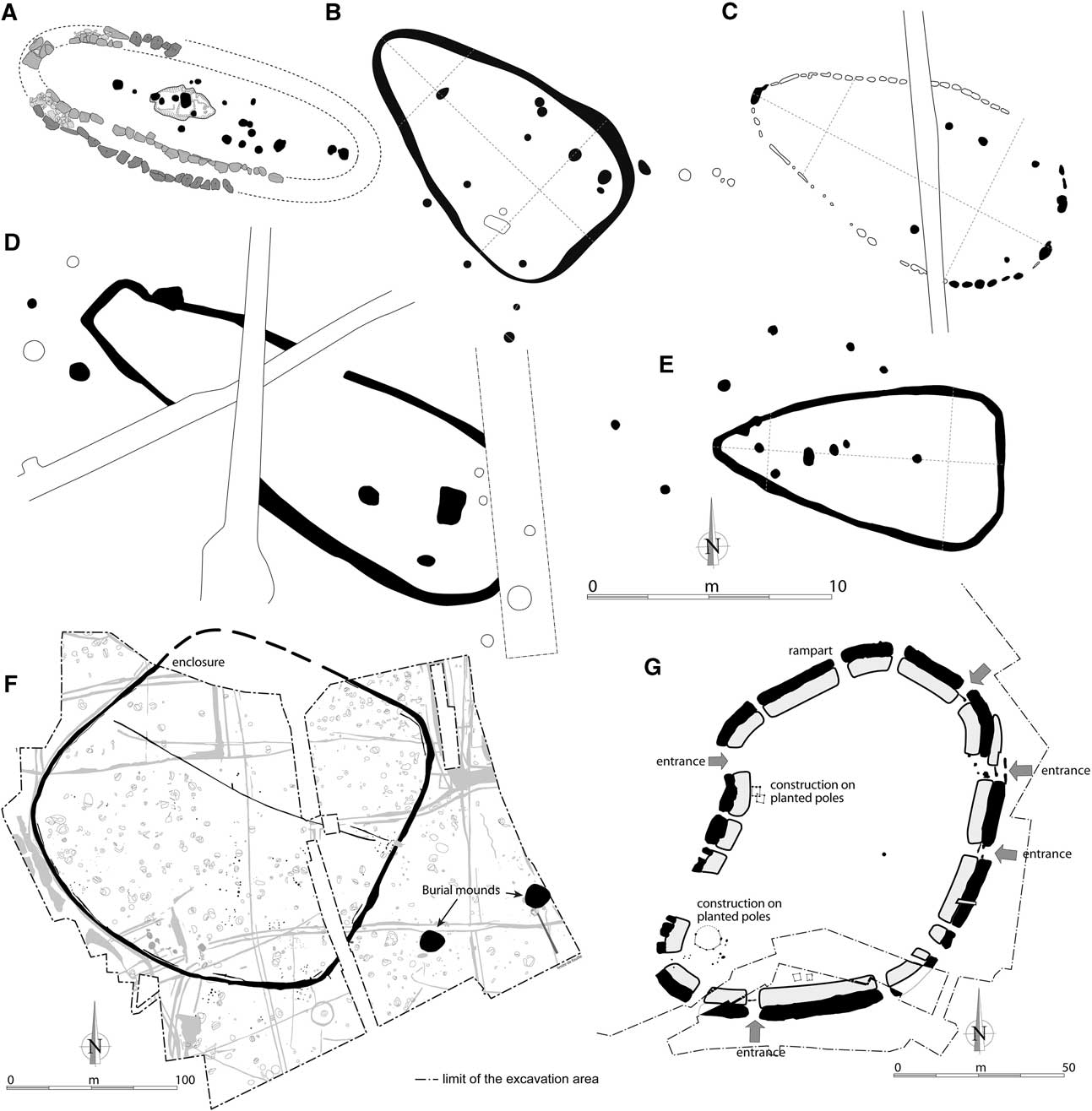
For the Recent Neolithic, the situation is similar with the exception of a small enclosure excavated, but not yet published, by S. Sicard at Drevers (Douarnenez, Finistère). For the transition between the Late Neolithic and Early Bronze Age, the Beg Ar Loued settlement is unique in Brittany because of the dry stone wall. However, several programmes of rescue archaeology have recently exhumed house structures having a pear-shaped plan with a foundation trench and internal post-holes (Blanchet et al. Reference Blanchet, Nicolas and Toron2012) at Bourg Saint-Pair (Bais, Ille-et-Vilaine), Le Merlet (Ploufragan, Côtes d’Armor), La Tourelle (Lamballe, Côtes d’Armor), and Kergovo (Carhaix, Finistère) (Fig. 18). These structures have the same size as the Beg ar Loued settlement dated to the Late Beaker/Early Bronze Age, having a length of 12–20 m and surface area in the range 48–96 m2 (Blanchet et al. Reference Blanchet, Nicolas and Toron2012). Radiocarbon dates obtained for these four houses are between 2660 and 2059 cal bp. Some decorated sherds founded inside the houses prove their belonging to the Beaker Culture. Two other similar structures were recognised by Roy (Reference Roy2011) during a recent rescue excavation at Creach ar Vrenn (Plouescat, Finistère). All these building remains are located along an east–west axis in the northern part of Brittany (Fig. 1) and seem to be few centuries older than the Beg ar Loued house.
Construction plans and associated structures, exhumed in Brittany and attributed to the Recent Neolithic and the Early Bronze Age (modifed from Pailler et al. Reference Pailler, Gandois, Ihuel, Nicolas and Sparfel2010; Blanchet et al. Reference Blanchet, Nicolas and Toron2012; Escats Reference Escats2012). A. Dry stone walls of the Beg ar Loued settlement (Molène island, this paper) during the Late Beaker/Early Bronze Age. B. Le Merlet (Le Merlet, Ploufragan, Côtes d’Armor; excavated by L. Aubry, published by Blanchet et al. Reference Blanchet, Nicolas and Toron2012). C. La Tourelle (Lamballe, Côtes d’Armor; excavated by S. Mentele, published by Blanchet et al. Reference Blanchet, Nicolas and Toron2012). D. Bourg Saint-Pair (Bais, Ille-et-Vilaine; excavated by D. Pouille, published by Blanchet et al. Reference Blanchet, Nicolas and Toron2012). E. Kergovo (Carhaix, Finistère; excavated by S. Toron, published by Blanchet et al. Reference Blanchet, Nicolas and Toron2012). F. Enclosure excavated at Bellevue (Lannion, Côtes d'Armor; Escats Reference Escats2012), one of only two settlements attributed to the Early Bronze Age in Brittany. G. Enclosure excavated at La Tourelle (Lamballe, Côtes d’Armor; excavated by S. Blanchet, published by Blanchet et al. Reference Blanchet, Nicolas and Toron2012) attributed to the Final Bronze Age

The only settlements that are contemporaneous with Beg Ar Loued and falling within the Early Bronze Age were excavated recently at Penancréac'h (Quimper, Finistère; excavated by J.-P. Le Bihan) and at Bellevue (Lannion, Côtes d'Armor; Escats Reference Escats2012). The latter forms an enclosure of 4 ha, bounded by a main ditch, a small interrupted ditch, and an embankment. It presents a monumental entrance open to the east. However, no domestic structure was discovered inside this enclosure (Fig. 18).
The Middle Bronze Age is not well known in the archipelago of Molène. Nevertheless, an imposing enclosure system corresponding to this period was recently recognised on the mainland at Leslouch (Plouédern, Finistère; Blanchet et al. Reference Blanchet, Forré, Hénaff, Mentele and Poilpré2010) where many well-preserved ceramic deposits were found. The enclosure covers an area of approximately 15 ha and was surrounded by large ditches. The internal space was apparently sub-divided by many small quadrangular fences. However, no structure indicating a possible house, such as pits or post-holes, was discovered on this site. In the Iroise Sea, a major settlement dated between 1500 and 1100 bc was excavated at Mez Notariou, on the nearby island of Ushant (Le Bihan & Villard Reference Le Bihan and Villard2010). The poorly preserved remains of a village which included a metal-working and ritual workshop area were excavated. Mez Notariou settlement was abandoned by its inhabitants in the Final Bronze Age, in the 9th–8th century bc, before being reoccupied in the Early Iron Age (Le Bihan & Villard Reference Le Bihan and Villard2010). This temporary abandonment of the site may be the result of a gradual shift towards wetter and colder climatic conditions and stronger storm events during this period on the West European coast (Long & Hughes Reference Long and Hughes1995; Long et al. Reference Long, Plater, Waller and Innes1996; Goy et al. Reference Goy, Zazo, Dabrio, Lario, Borja, Sierro and Flores1996; Reference Goy, Zazo and Dabrio2003; Van Geel et al. Reference Van Geel, Buurman and Waterbolk1996; Eiriksson et al. Reference Eirıksson, Knudsen, Haflidason and Heinemeier2000; Barber et al. Reference Barber, Chambers and Maddy2003; Dark Reference Dark2006; Charman Reference Charman2010). Along the French coast of the Atlantic and the English Channel, the enhanced period of storminess c. 900–700 bc is widely recognised in coastal sedimentary infills (Pontee et al. Reference Pontee, Tastet and Massé1998; Tastet Reference Tastet1998; Tastet & Pontee Reference Tastet and Pontee1998; Clavé Reference Clavé2001; Clavé et al. Reference Clavé, Massé, Carbonel and Tastet2001; Billeaud et al. Reference Billeaud, Tessier and Lesueur2009; Sorrel et al. Reference Sorrel, Tessier, Demory, Delsinne and Mouaze2009; Reference Sorrel, Tessier, Demory, Baltzer, Bouaouina, Proust, Menier and Traini2010; Lespez et al. Reference Lespez, Clet-Pellerin, Davidson, Hermier, Carpentier and Cador2010; Tessier et al. Reference Tessier, Billeaud, Sorrel, Delsinne and Lesueur2012). These conditions may explain why very few remains dated to the Final Bronze Age were discovered on the islands of the Molène archipelago (Stéphan et al. Reference Stéphan, Pailler, Tresset and Gandois2013). As a result of induced difficulties for agricultural and fishing practices, the island territories may have been deserted for a few decades or centuries in Brittany, in favour of sites located on the continent, where many settlements dating from the Late Bronze Age have been discovered in recent years by rescue archaeology. Thus, a hamlet comprising nearly 12 houses erected on poles has been discovered at Lenn Sec’h (Caudan, Morbihan; excavated by M. Levan & F. Le Boulanger). These structures are circular and very similar to that found in the enclosure of Lamballe (Côtes d’Armor; Blanchet Reference Blanchet2012) associated with several granaries.
‘Le monde des morts’
The burial monuments found in the Molène archipelago have strong morphological similarities with those studied on the mainland, regardless of the period, from the Early Neolithic to the Final Bronze Age. The few radiocarbon dates that we have obtained simply reinforce existing chronological models for the different types of architectural construction. However, our research shows a strong geographic concentration of burial remains which helps to refine the distribution patterns at a regional scale.
For the first part of Middle Neolithic, the morphology of the long barrow excavated on Ledenez Vihan Quéménès shows strong analogies with that of other long barrows excavated in Brittany (Ramé Reference Ramé1864; Giot & L’Helgouach Reference Giot and L’Helgouach1955; Reference Giot and L’Helgouach1956; Giot et al. Reference Giot, Briard and Onnée1995; Briard et al. Reference Briard, Briard, Chalavoux, Houeix, Larcher, Muratore, Quérat and Pennec1989; Briard Reference Briard1992; Le Roux et al. Reference Le Roux, Lecerf and Gautier1989), the geographically closest example being that of Souc’h in Plouhinec (Le Goffic Reference Le Goffic2004). Radiocarbon dating (UBA-16738, 5624±29 bp) of a sample from the foot of one of the standing stones surrounding the monument calibrates to 4520–4366 cal bc (2 sigma). This result, which attributes the construction of the monument to a period around the middle of the 5th millennium, is perfectly coherent with the model produced by Boujot & Cassen (Reference Boujot and Cassen1992) in which long barrows are an architectural category pre-dating passage tombs. The archaeological surveys carried out in the archipelago led to the identification of other long barrows attribued to this period in the islands of Trielen (Sparfel & Pailler Reference Sparfel and Pailler2004), Béniguet (Sparfel & Pailler Reference Sparfel and Pailler2009), and Molène (Pailler & Sparfel Reference Pailler and Sparfel2006).
For the second part of the Middle Neolithic, the morphology of the passage tombs discovered in the Molene archipelago is quite similar to their continental counterparts. Their high concentration in the archipelago echoes that of the coast the northern Finistère (Sparfel & Pailler 2006). Other coastal areas in Brittany, such as the Pays Bigouden, the Cap Sizun, the Pays de Lorient, and the Gulf of Morbihan have been well known for a long time for their high density of passage tombs (Daniel Reference Daniel1960; L’Helgouac’h Reference L’Helgouac’h1965), to which must be added the hinterland of the Landes de Lanvaux (Morbihan) and the Landes de Saint-Just (Ille-et-Vilaine) (Briard et al. Reference Briard, Gautier and Leroux1995). Finally, the monuments attributed to the Recent Neolithic and the Bronze Age in the archipelago are no different from those known on the mainland. Burial mounds and cists are distributed either singly or more often grouped in small cemeteries.
CONCLUSION
The excavation of the Beg ar Loued settlement site, together with various surveys conducted to date, are only preliminary. The palaeoenvironmental studies in progress (pollen and foraminifera analyses) are promising. They should enable us to reconstruct Holocene vegetation and to more accurate determine variation in sea level and the chronology and rate of insularisation of the Molène plateau. The latter study has an immediate archaeological implication with regard to several recently identified fishery dams. These are located very low down the foreshore and can only be seen during spring tides (tidal coefficient greater than 105). Unfortunately, due to a lack of dating elements, it is currently impossible to say at what period these dams were used. Through the in-depth study of sea level variation we are able to put forward a chronological attribution for these structures: their use at the end of the Neolithic and the beginning of the Bronze Age is not improbable and would provide a link with the fish bone analyses.
The new discoveries confirm the exceptional wealth of the archaeological heritage of the Molène archipelago. Thanks to the general conservation of megalithic monuments, the archipelago’s islets are a genuine archaeological repository. Nevertheless, this gratifying observation should not overshadow the fact that these territories are subject to strong marine erosion and that many of the deposits identified will disappear over the coming years due to the action of the sea and wind, as is the case for the majority of the shell middens discovered in cliff sides. It is therefore necessary, in the case of important sites for the understanding of a given period, to be able to act before it is too late.
The islands of the Iroise Sea with their megalithic heritage, shell beds, settlements, and funerary structures present an exceptional opportunity to understand human societies as a whole at the end of the Neolithic and beginning of the Bronze Age. The combination of archaeological data with the reconstruction of ancient insular landscapes has enabled us to outline the main features of the occupation of these territories and the functioning of prehistoric societies from the Neolithic to the end of the Bronze Age in the west of the Armorican Massif. The geography of the Molène archipelago at the beginning of Middle Neolithic II (c. 4300 bc) appears to show that these populations benefitted from quite large areas of land around the hills which formed the current islands. We put forward the hypothesis that the absence of settlements for this period in the archipelago is due to the erosive effects of marine transgression, which has led to the disappearance of these remains from current landscapes. From the beginning of the Late Neolithic populations lived and occupied this land on a permanent, or at least seasonal, basis, as demonstrated by the study of the content of several middens. These prehistoric insular societies appear to have mainly had a self-sufficient lifestyle, as shown by the almost exclusive use of local resources for provision of food, the manufacture of tools, and building of monuments. All these elements of everyday life shed new light on the archaeology of Brittany and, in particular, the lifestyle of coastal groups in western France. Indeed the Molène archipelago has many funerary structures, in particular Zoulierou necropolis on Molène, with similar groups of long barrows dating from the Early Bronze Age known on the mainland near the coast and in the Monts d’Arrée area (Briard Reference Briard1984). There is little doubt that this cemetery was partly contemporary with the Beg ar Loued settlement and the opportunity to excavate contemporary graves must immediately be grasped. Settlements, graves, megaliths, shell middens, embankments, fish dams, etc: all these structures, which are at least partly contemporaneous, correlated with palaeoenvironmental analyses, offer a vision of a ‘global archaeology’ on the scale of this small archipelago. Such an approach, combining many disciplines, is quite novel in Brittany and deserves to be pursued in the long term.
Acknowledgements
The Molène Archaeological Programme is supported, financially and materially, by the General Council of Finistère, the Ministry of Culture and Communication (DRAC de Bretagne), CNRS, MNHN, the Institut universitaire européen de la Mer (Université de Bretagne occidentale), the Communauté de Communes du Pays d’Iroise, the Compagnie maritime Penn ar Bed, the Conservatoire du Littoral and the association SEPNB – Bretagne vivante, all of which we would like to thank greatly. The success of this programme owes a great deal to the confidence granted by the different managers or owners of the islets (ONCFS, SEPNB – Bretagne Vivante, Conservatoire du Littoral). We extend our thanks to Pierre Yesou, Louis Brigand, Jean-Yves Le Gall, David Bourles, Hélène Mahéo Denis Bredin, David and Soizic Cuisnier, M. de Kergariou, Marcel Masson, Jean-François Masson, Marie-Thérèse Callac and Jean-François Rocher. Thanks to Gabriela Marisol Armentano and Karoline Mazurié De Keroualin for the translation of the abstract in Spanish and German respectively.