

Asia, a region grappling with the impacts of climate change, increasing natural disasters, and transboundary water issues, faces major challenges to water security. Water resources there are closely tied to the dramatic Hindu-Kush Himalayan (HKH) mountain range, where over 46,000 glaciers hold some of the largest repositories of fresh water on earth (Qiu Reference Qiu2010). Often described as the water tower of Asia, the HKH harbors the snow and ice that form the headwaters of the continent's major rivers (Bandyopadhyay Reference Bandyopadhyay2013). Downstream, this network of river systems sustains more than 1.3 billion people who depend on these freshwater sources for their consumption and agricultural production, and increasingly as a source of hydropower (Immerzeel, Van Beek, and Bierkens Reference Immerzeel, Van Beek and Bierkens2010; National Research Council 2012; Rasul Reference Rasul2014).
The HKH region has much at stake as increasing global temperatures melt the world's cryosphere, the system of frozen water covering the planet. Just how much and how fast this water flows from mountain environments has broad implications for water resources downstream. The steep terrain of Asia's mountains also makes the region especially susceptible to natural disasters such as flash floods and landslides. Furthermore, the majority of rivers that emerge from the Himalayas are transboundary systems that flow across several, often-contested political borders. The potential for conflict in such an expansive and dynamic hydrologic system has garnered the HKH significant attention among international organizations and development agencies that frequently cite climate change and the threat of melting glaciers as serious risks to regional water security, further exacerbated by tremendous population growth (Bandyopadhyay Reference Bandyopadhyay2013; Matthew Reference Matthew2012; National Research Council 2012; Shah and Giordano Reference Shah and Giordano2013).
Responding to the threat of changes in the timing and amount of water availability in coming decades, concerns over vulnerability to water scarcity emerge in both discourse and policy. For vast regions of Asia, which depend on monsoonal precipitation in the summer to meet essential water needs, a shift to earlier peak discharge could benefit the agricultural industry immensely by providing more water during the drier spring season (Immerzeel et al. Reference Immerzeel, Van Beek and Bierkens2010). However, not all sectors will benefit equally and who will win and lose most as a result of this shift remains largely unknown. Consequently, water security has emerged on the agendas of organizations and agencies as diverse the US Environmental Protection Agency and National Intelligence Council, the World Economic Forum, the World Bank, and the United Nations (K. Bakker Reference Bakker2012; Cook and Bakker Reference Cook and Bakker2012; Lautze and Manthrithilake Reference Lautze and Manthrithilake2012). Many of these institutions are particularly concerned with the glaciated HKH region and have made robust investments in scientific research to understand Himalayan water security with a focus on the vulnerability of the cryosphere.
Transboundary water issues further complicate the region's water security with issues of allocation, particularly in regard to which stakeholders control flows both domestically and internationally. Water resources from transboundary rivers are not always clearly or fairly allocated, as deeply seated social, political, and economic relations limit the leverage of historically marginalized nations and communities. Furthermore, the growing populations and resource needs that come with a higher quality of life in Asia will continue to affect prospects for water security. India has more than 400 million citizens who currently lack access to electricity, and development of hydropower upstream is perceived to be intricately connected to improving the quality of life of India's citizens (Grumbine and Pandit Reference Grumbine and Pandit2013). Negotiated compacts for water-sharing, or the lack thereof, continue to be a potential source of tension as “hoarding water” through dam construction becomes a looming threat, particularly as water supplies diminish and demand from Asia's booming population only continues to increase.
The implications of such a precarious water situation, however, are largely determined by the resolution at which scarcity is discussed and negotiated. Since watersheds are telescopic concepts that collect and shed river basins as they zoom to finer or coarser resolutions, policymakers can naturalize their political interests within the region, be it hydropower development or drought mitigation, by strategically assembling a network of river basins until scarcity becomes unarguably visible. While this is not to say that scarcity does not exist across scales, it is important to acknowledge that normative interventions are made at a particular scale and that this selection cannot be understood as a strictly “natural” decision. Projecting a future of profound water insecurity in High Asia and the associated vulnerability of the region's populations is a complex, politically shared task that must consider both natural variations in the water cycle and human interventions to manipulate it in their interests.
Geography and Climate
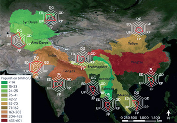
Approximately one-third of the global population depends to some extent on water resources that originate in the mountains of High Asia (Krishna Reference Krishna, Singh, Singh and Haritashya2011). Here we refer to High Asia as the HKH and Karakorum ranges of South Asia; the Pamir, Tien Shan, and Altai mountain ranges of Central Asia; the Tibetan Plateau; and the Hengduan Mountains to the east of the Tibetan Plateau. Ten major rivers begin their journey from these mountains (see figure 1). While the Yellow and Yangtze river basins are confined within the borders of China and the Irrawaddy river basin is confined within Myanmar, the other river basins are transboundary, flowing across multiple political borders. These include the Mekong, Salween, Brahmaputra, Ganga, Indus, Amu Darya, and Syr Darya rivers. Their downstream catchment areas comprise a significant proportion of the Asian continent and support the majority of its population.
Multiple facets of future water shortage. The basins of ten large rivers that originate in Asia's high mountains vary in their total population (numbers for the year 2000 by color), in their susceptibility to water scarcity, and in the relative importance between potential causes for future scarcity: dependence on glacier melt (DG), groundwater depletion (GD), reservoir potential (RP), future precipitation (FP), uncertainty in future precipitation (UP), and economic development (ED). Radar charts: qualitative ranking between low susceptibility and/or large coping capacity (1) and high susceptibility and/or small coping capacity (5) (Immerzeel and Bierkens Reference Immerzeel and Bierkens2012).

The world's 115 highest peaks, all above 7,000 meters in elevation, can be found in High Asia, and a large portion of the region is at elevations high and cold enough to support seasonal or perennial snow. In the Himalayas alone more than 30,000 square kilometers are covered with ice, and the region encompassing High Asia is often referred to as the world's “third pole” (Bagla Reference Bagla2009), as it holds more frozen fresh water than any region outside the high latitudes.
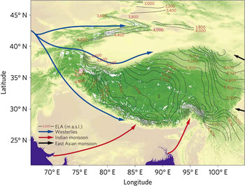
The climate of South Asia, and to a great extent its water resources, is heavily influenced by the South Asian summer monsoon. Central Asia, in contrast, is an arid climate, which receives most of its moisture via westerly winds (see figure 2). Monsoon precipitation is blocked from the western reaches of High Asia by the HKH. Thus an arid, continental climate persists in the western portion of High Asia and across the Tibetan Plateau.
Wind patterns in High Asia, indicating that the eastern Himalayas receive moisture sourced from the South Asian (Indian) monsoon, and areas to the west are dominated by the Westerlies. White indicates distribution of glaciers, and isolines represent glacier equilibruim line altitudes, which divide the accumulation (mass gain) and ablation (mass loss) zones (Yao et al. Reference Yao, Thompson, Yang, Yu, Gao, Guo, Yang, Duan, Zhao, Xu, Pu, Lu, Xiang, Kattel and Joswiak2012).

The mountains of High Asia thus cover a vast area with diverse weather patterns and historically limited infrastructure for ground-based monitoring of water resources. The ground-based measurements that do exist are not always sufficient for identifying the spatial and temporal variability within the hydrological cycle. In many mountain basins, glacier melt, snow melt, and rain contributions need to be differentiated from each other and from groundwater's contribution to flows (Armstrong Reference Armstrong2011). Remote sensing technology is able to track certain changes in snow and ice, but cannot fully account for the relative contributions of melt, precipitation, and groundwater to river discharge. Thus a combination of ground-based observations and remote sensing imagery is being developed and used to improve understanding of the role snow and ice play in the regional water cycle.
Snow and Ice as Water Storage
In the mid-latitude, highly populated regions of the globe, snow and ice at high elevations serve as storage for fresh water until it melts in the spring. Precipitation that falls as snow remains in the solid state until rising temperatures induce melt and it is able to circulate onward through the hydrologic system. Downstream communities that depend on meltwater from glaciers and the seasonal snowpack rely on the timing and volume of these freshwater pulses. Historically, the delaying effects of snow and ice storage have created a peak in water availability during the summer months, when meltwater conveniently coincides with peak demands for irrigation water and hydropower generation downstream (Singh and Bengtsson Reference Singh and Bengtsson2004).
However, higher air temperatures associated with climate change could decrease the amount of freshwater stored in the snowpack and in glaciers. As more precipitation falls as rain instead of snow, rainwater will travel downstream much faster, often within hours or days of the storm, versus a longer time frame for snow and even longer for glaciers, which can store water resources for millennia. The result may be that peak discharges shift earlier in the spring, affecting the quantity of water available downstream in summer months when demand increases. Confounding this issue is the fact that increases in air temperature can also result in higher amounts of precipitation, possibly delaying or offsetting this potential problem of allocation and distribution.
At present there is considerable misinformation and misunderstanding in the discussion of High Asia's glaciers, the potential impact of climate change on their melt regimes, and the contribution they make to downstream water resources. This confusion is exacerbated by the broad range of estimates of meltwater contributions to river discharge of the major rivers draining High Asia, studies that are influenced by regional differences and different methodological approaches (Barnett, Adam, and Lettenmaier Reference Barnett, Adam and Lettenmaier2005; Immerzeel et al. Reference Immerzeel, Droogers, De Jong and Bierkens2009; Kaser, Grosshauser, and Marzeion Reference Kaser, Grosshauser and Marzeion2010; Racoviteanu, Armstrong, and Williams Reference Racoviteanu, Armstrong and Williams2013). Earlier research led to inaccurate conclusions, such as Barnett et al.’s (Reference Barnett, Adam and Lettenmaier2005) estimate that 70 percent of summer flow in the Ganga River could be attributed to glacial ice melt. Although disproved by more recent studies (Immerzeel et al. Reference Immerzeel, Droogers, De Jong and Bierkens2009; Racoviteanu et al. Reference Racoviteanu, Armstrong and Williams2013), exaggerated predictions were published in the 2007 Intergovernmental Panel on Climate Change report alongside dramatic imagery of the region's most critical rivers running dry by 2035 due to the disappearance of glaciers (Cruz et al. Reference Cruz and Parry2007).
While these messages are alarming in light of the rising temperatures associated with climate change, their accuracies remain uncertain. Recent work is beginning to suggest that contributions from glacier melt are not as significant as previously thought and actually vary significantly by region. Immerzeel et al. (Reference Immerzeel, Droogers, De Jong and Bierkens2009) found that ice melt contributes 32 percent and snowmelt contributes 40 percent to annual streamflow in the Upper Indus Basin, an area that is 9.9 percent glacierized. This highlights the need to distinguish snow melt, an annually recharged water source, from glacier melt, which will decline if ice area reduction continues as projected. Based on water isotope data from the Langtang River in Nepal, postmonsoon results show 70 percent of river discharge within 5 kilometers of a glacier terminus is snow or ice meltwater. However, the proportion of melt decreases to less than 30 percent at a distance of 30 kilometers from the terminus, and is less than 10 percent at a distance of 50 kilometers downstream, at lower elevations where the majority of people live (Racoviteanu et al. Reference Racoviteanu, Armstrong and Williams2013). The remainder of flow in these cases is assumed to be groundwater. Further work has shown the potential for isotopes and major chemistry data to separate more than two sources in a glacier-influenced system (Wilson et al. Reference Wilson, Williams, Kayastha and Racoviteanu2016). This work at the localized scale can be used in concert with remote-sensing based hydrologic modeling to improve confidence in results at broader scales. However, profound variability in climate indicators and rates of discharge that occur at the sub-basin level means that aggregation to larger river basins must be done cautiously and with clear communication about uncertainty to policymakers who negotiate critical downstream allocations based on these conclusions.
Changes in Natural Water Storage
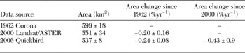
The cryosphere is front and center in the dialogue on anthropogenic climate change because it experiences a tipping point when melting from the solid to liquid phase, making snow and ice bellwether indicators of rising air temperatures (Williams, Losleben, and Hamann Reference Williams, Losleben and Hamann2002). In the monsoon-influenced eastern Himalaya, satellite records show a 10.3 percent decline in ice area between 1962 and 2006 based on a subset of both clean and debris-covered glaciers (see table 1), with the retreat rate at its highest (0.43 percent yr-1) in the most recent decade (Racoviteanu et al. Reference Racoviteanu, Arnaud, Williams and Manley2014). In the western Himalayas, the satellite record shows a greater decrease in ice area: 21 percent between 1962 and 2001 (Kulkarni et al. Reference Kulkarni, Bahuguna, Rathore, Singh, Randhawa, Sood and Dhar2007). At the same time, glaciers in the Karakorum are generally stable or expanding (Gardelle, Berthier, and Arnaud Reference Gardelle, Berthier and Arnaud2012), potentially due to increases in precipitation over the last forty years, indicating the fundamental role snow plays in ensuring the longevity of glaciers (Archer and Fowler Reference Archer and Fowler2004).
Glacier area changes for a selection of fifty glaciers in Nepal and Sikkim (Racoviteanu et al. Reference Racoviteanu, Arnaud, Williams and Manley2014).

Rising temperatures can reduce the number of days an area is covered with snow, or reduce the area over which snow cover persists. Regions of Central Asia are seeing a decline in the number of snow-covered days by as much as one day per year (1986–2008) in the Pamir Mountain Range and the Amu Darya basin at elevations above 4,000 meters (Zhou, Aizen, and Aizen Reference Zhou, Aizen and Aizen2013). In southeastern Tibet, the headwaters of the Brahmaputra River, Gao et al. (Reference Gao, Williams, Fu, Wang and Gong2012) report that the length of the snow-covered season is decreasing at lower elevations because of an increase in air temperatures. However, at higher elevations an increase in snow precipitation appears to compensate for increasing air temperatures such that the snow-free period has decreased. A decline in snow-covered area is seen in winter at elevations below 6,000 meters in the Himalayas, but an increase is seen in autumn at elevations above 4,000 meters (Maskey, Uhlenbrook, and Ojha Reference Maskey, Uhlenbrook and Ojha2011).
A more complete picture of the regional water balance is provided by gravity measurements, which are correlated with distribution of mass around the planet. GRACE (Gravity Recovery and Climate Experiment) satellite measurements estimate net gain or loss of ice and other forms of stored water (e.g., groundwater) and show a loss of mass in High Asia of 4 ± 20 gigatons yr-1, a value with high uncertainty and lower mass loss than previous estimates (Jacob et al. Reference Jacob, Wahr, Pfeffer and Swenson2012). The discrepancy with previous studies is attributable to the fact that results from field measurements are often extrapolated across a region, even if the location of the measurements is not representative of the system. In glacier research, measurements of mass change are often taken at lower-elevation, accessible field sites that may be experiencing net mass loss, but such values cannot necessarily be extrapolated to ice with different hydrometeorological settings (Kargel et al. Reference Kargel, Cogley, Leonard, Haritashya and Byers2011).
Black carbon deposition and dust on snow are also emerging areas of research that have sparked great concern over the possibility of accelerated snow and ice melt at earlier times of the year. As darker-colored material accumulates on ice surfaces, it lowers reflectivity and allows increased absorption of solar radiation. The amount of black carbon being deposited in the Himalayan/Tibetan Plateau region has been steadily increasing in recent decades due to soot generation from the burning of biomass and vehicle emissions on the Indian subcontinent, as well as longer-range transport from East Asia and beyond (Lu et al. Reference Lu, Streets, Zhang and Wang2012). Additionally, dust is swept from arid regions of Southwest Asia and deposited onto the western mountains of High Asia, potentially accelerating snow and ice melt there (Gautam, Hsu, and Lau Reference Gautam, Hsu and Lau2013). The net impact of dust and black carbon on the High Asian cryosphere has yet to be quantified, but results from studies of a similar dynamic in the Colorado River Basin in North America suggest potential implications. In that basin, peak runoff has been observed to occur three weeks earlier in years of heavy dust, and approximately 5 percent of annual discharge is lost due to extra evaporation from the surface and transpiration by vegetation (Painter et al. Reference Painter, Deems, Belnap, Hamlet, Landry and Udall2010).
The possibility of losing some of the glaciers in the world that are most relevant for providing water resources has understandably catalyzed widespread concern over global water scarcity and has led to powerful narratives of regional insecurity in Asia, which continue to persist even as the validity of these stories is complicated by more nuanced scientific data. The question of how to most accurately determine trends in the Himalayan cryosphere looms as challenging as ever. As Immerzeel et al. (Reference Immerzeel, Van Beek and Bierkens2010, 1382) note: “The relevance of snow and glacial melt for Asian river basin hydrology therefore remains largely unknown, as does how climate change could affect the downstream water supply and food security.” Furthermore, while an overall reduction in the frozen bank of Himalayan glaciers will undoubtedly affect long-term flows and place downstream stakeholders in greater dependence on the fickle monsoon, an impending water crisis cannot be blamed on glaciers or nature alone. Climate change will certainly have unsettling consequences, but the insecurity the High Asia region faces over an adequate provision of future water resources is not simply a deficit of nature but also a crisis of its own consumption and the politics of uneven distribution.
The effect of climate change on groundwater systems is “essentially unknown” (Viviroli et al. Reference Viviroli, Dürr, Messerli, Meybeck and Weingartner2007). It can be inferred that the extent to which populations utilize groundwater will be influenced by the availability of surface water resources—with people turning to groundwater if other sources of water diminish. GRACE data has recently shown that the Indus basin is ranked as the second most overstressed groundwater aquifer in the world (Richey et al. Reference Richey, Thomas, Lo, Reager, Famiglietti, Voss, Swenson and Rodell2015). Even in countries like Nepal, where river systems are not overly stressed by irrigation, farmers increasingly tap groundwater reserves due to increased access to pumps and the stability groundwater provides. Birkenholtz (Reference Birkenholtz2009a, Reference Birkenholtz2009b), however, highlights the political implications of a growing dependence on the extraction of regional groundwater in his work in Rajasthan, India, where scarcity becomes exacerbated at the local level as marginalized populations must struggle for access to a highly coveted resource. While prospects for snow and ice in the face of climate change are grim, groundwater resources are also at risk of unsustainable use, leaving an uncertain future for reliance on either of these storage systems.
Natural Hazards
This upstream-downstream bond extends beyond water as a resource, to its power to trigger acute natural disasters. Water-related disasters in Asia are an ever-present threat to the safety and livelihoods of mountain people and those downstream. Largely specific to the steep, unstable terrain of the young mountains in High Asia, Glacier Lake Outburst Floods (GLOFs) and Landslide Dam Outburst Floods (LDOFs) can generate flash flooding with little warning.
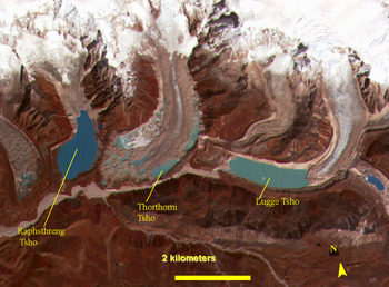
A GLOF event happens when a moraine dam blocking the downstream flow of meltwater fails. GLOFs have begun to receive attention from concerned governments and institutions in connection with climate change vulnerability assessments and impact mitigation. This follows a long history of devastation from GLOFs—documented back to 1941 in Peru (Carey Reference Carey2005) and 1935 in the central Himalayas, as well as evidence of a major event dated to ~1550 CE in Nepal (Mool et al. Reference Mool2011). Lugge Tscho, a lake in northern Bhutan, was the site of a GLOF in 1994 that killed twenty-one people, and in subsequent years the lake has reformed (see figure 3), posing a continued threat (Komori Reference Komori2008). Researchers have devoted significant attention to using satellite imagery to map the moraine-dammed lakes that are potential sources for GLOFs in High Asia. In Nepal alone, 1,466 have been identified and 21 are considered potentially dangerous (Mool et al. Reference Mool2011). In locations known to be at higher risk of dam failure, the focus has shifted to risk-reduction, including engineering solutions to preemptively drain moraine-dammed lakes (e.g., Imja Lake, Nepal).
Formation of proglacial lakes in the Bhutan Himalaya. Image from an ASTER false-color image acquired on November 20, 2001. Glacial lakes that are dammed behind terminal moraines present a risk for GLOFs.

It may seem unlikely that the creation of dammed lakes could escape detection, but the May 2012 Seti River disaster in Nepal is a recent example of how LDOFs are just such a threat. Seventy-two people were killed when the dam holding back a lake created by a landslide burst and sent a flood of water and debris more than 20 kilometers downstream. The downstream city of Pokhara received advance warning of the flood, averting greater catastrophe (Bhandary, Dahal, and Okamura Reference Bhandary, Dahal and Okamura2012). A series of landslides in the weeks before the flood had dammed the river in its glacierized and unpopulated headwaters—events that were only documented after the disaster by examination of a time series of satellite imagery. Residents downstream noticed a reduction in discharge in late April after initial damming of the river upstream, but did not associate the low flow with a potential flood disaster in the coming weeks (NASA Earth Observatory 2014). Limited monitoring was a contributing factor in missing this potentially lifesaving warning sign.
In contrast to the undetected landslide dam on the Seti River, a landslide on Nepal's Sun Kosi River on August 2, 2014, occurred in an inhabited region, killing up to 180 people and damming the river, creating a large lake more than three kilometers in length. Nepali security forces took swift action, using explosives to control a gradual release of water from behind the dam in an attempt to limit further damage from an LDOF (Shrestha et al. Reference Shrestha, Khanal, Shrestha, Nibanupudi and Molden2014). On September 7, 2014, the dam burst without warning, attributed to both a heavy rainfall event and continued excavation of channels by army personnel. No fatalities were reported from the Sun Kosi LDOF, and downstream damage was considered minor thanks to the efforts taken to minimize the risk (Petley Reference Petley2014). Because rainfall can be a source of slope instability and trigger landslides, the potential for increasing intensity and amounts of liquid precipitation with climate change could exacerbate this risk (Turner and Annamalai Reference Turner and Annamalai2012).
Floods also impact vulnerable communities occupying the downstream floodplains of High Asia. One such extreme event was the August 2014 inundation of Nepal's Lower Karnali basin, which claimed 222 lives and destroyed or damaged over 20,000 homes. The extreme rain event and associated inundation also displaced nearly 7,000 households along the river, even as an early warning system reduced the potential impact (MacClune et al. Reference MacClune, Venkateswaran, Mani Dixit, Yadav, Maharjan and Dugar2015; Pokharel Reference Pokharel2014. While such disasters are expected to increase as a consequence of climate change, there are additional social and political forces that shape vulnerability to flooding and other hydrologic disasters.
Other regions in High Asia face extreme seasonal droughts. The Amu Darya and Indus basins rate the highest in Asia for overall vulnerability to future water scarcity (see figure 1; Immerzeel and Bierkens Reference Immerzeel and Bierkens2012). Vulnerability takes into consideration both a basin's risk factors and its coping capacity. The Yellow River and Indus River are most susceptible to water scarcity, but the Indus and Ganga-Brahmaputra basins have more overall vulnerability than others when governance, economy, social issues, environmental issues, hazards, and water scarcity are considered (Varis, Kummu, and Salmivaara Reference Varis, Kummu and Salmivaara2012). The Indus River basin, home to more than 200 million people, depends on a greater amount of water generated by snow and ice melt than from rainfall and groundwater in downstream areas (Immerzeel et al. Reference Immerzeel, Van Beek and Bierkens2010). This means that approximately 75 percent of annual flow in the Indus originates in mountainous terrain (Messerli, Vivroli, and Weingartner Reference Messerli, Viviroli and Weingartner2004). The meltwater sourced in upstream areas is the largest contributor to irrigation use and reservoir storage in the basin, making the Indus more vulnerable to changes in the cryosphere. In South Asia, the Indus and Brahmaputra basins are expected to be most susceptible to future reductions in flow volume due to relatively high glacierized areas, 2.2 percent and 3.1 percent of the total catchment sizes respectively (Immerzeel et al. Reference Immerzeel, Van Beek and Bierkens2010). Glaciers in the eastern Himalayas, largely the headwaters of the River Ganga, may be less sensitive to climate change than other regions because monsoon precipitation at high altitudes continues to provide significant snow accumulation each year (Racoviteanu et al. Reference Racoviteanu, Arnaud, Williams and Manley2014).
Nonetheless, the potential impacts of climate change on the region's hydrological landscape have led many international NGOs, development agencies, and global institutions to construct and circulate powerful discourses around the region's increasing vulnerability to climate-induced natural disasters. Embedded in this framing of a growing water crisis is the assertion that climate change will disproportionately impact marginalized populations who live on riparian floodplains and in headwater mountain communities. Climate scientists have suggested that a shift toward greater vulnerability will be expressed through an increasingly unpredictable and more intense monsoon. This change is expected to simultaneously produce violent wet season floods while causing seasonal water scarcity (Matthew Reference Matthew2012; National Research Council 2012; Racoviteanu et al. Reference Racoviteanu, Armstrong and Williams2013; Shah and Giordano Reference Shah and Giordano2013; Ziegler et al. Reference Ziegler, Wasson, Bhardwaj, Sundriyal, Sati, Juyal, Nautiyal, Srivastava, Gillen and Saklani2014). Already floods triggered by relentless rainfall, associated landslides, and the failure of human-made or natural dams account for a greater proportion of deaths and damages than any other natural disaster in the HKH region (ICIMOD 2013a, 2013b; Shrestha and Bajracharya Reference Shrestha and Bajracharya2013). Furthermore, in the last decade the frequency of transboundary floods has increased more significantly in Asia than any other continent, with the greatest number of events occurring in the Ganga-Brahmaputra-Meghna basin (M. Bakker Reference Bakker2009).
In counterpoint, several Nepalese with extensive experience in national water policy and development have complicated standard explanations for disasters like the 2014 floods in the lower Karnali. They suggest that the social and economic costs may be less a consequence of climate change—or a purely “natural” disaster—than a result of poor governance and the historical misapplication of river management technologies that exacerbate flooding and expose already marginalized communities to greater risk (Dixit Reference Dixit2009; Gyawali Reference Gyawali2001, Reference Gyawali2003). Dixit (Reference Dixit2009), for example, suggests that the privileging and promotion of certain structural flood mitigation solutions has eroded communities’ own adaptive capacity by fostering a “false sense of security” in state-provided solutions.
Recently, other international scholars have added evidence in support of this assertion by highlighting how dam construction and technical water (mis)management strategies exacerbate damage by creating “hydro-hazardscapes” (Mustafa Reference Mustafa2013), which deposit tons of sediment flushed from upstream construction sites onto lower villages and farms (Alley Reference Alley and Sanghi2014; Alley, Hile, and Mitra Reference Alley, Hile and Mitra2014; Mustafa and Wrathall Reference Mustafa and Wrathall2011). Thus, while increased flood risk and vulnerability can be understood to some degree as a direct consequence of climate change, they are also a result of contemporary approaches to basin management, including engineered channels and embankments, and the political networks that position them.
Transboundary Water Issues
Much of the political discourse on regional water security tends to blur the High Asia region into one, powerful image of scarcity in which areas facing actual water shortages obscure the significant abundance of water resources in other locales. This is because in order to make visible a dramatic shift from abundance to scarcity in terms of water availability, multiple river basins and nations are combined into one system, muting the incredible variability in climate and rainfall patterns. Such a perspective allows regional water stress to become visible and therefore a reality demanding urgent action. Yet at any finer resolution the story of scarcity largely collapses. For example, nations like Bhutan and Nepal—geographically positioned in the Himalayan headwaters with substantial water resources and limited water demands imposed by their populations—are expected to continue to have an abundance of water until at least 2050 (Barnett et al. Reference Barnett, Adam and Lettenmaier2005; National Research Council 2012).
However, downstream nations with less direct control over management of source waters often also have greater demands in terms of water use. India, for example, is expected to face a 50 percent deficit between water supply and demand by 2030. Yet it depends on nearly 350 billion cubic meters of surface water flowing from upstream Chinese territories (Chellaney Reference Chellaney2014). Therefore, if water security were framed as an issue faced by sub-basins or individual communities, cities and nations with high demand and limited supply would not as easily be able to claim rights as stakeholders in upstream water management and would be forced to cope with scarcity within their own political boundaries. In this way, the mobilization of a broader scale in discourse becomes necessary both for justifying a story of scarcity and for the positioning of risks and responsibilities among upstream and downstream communities bound together in a common hydrologic system.
Control of transboundary water resources lies between the extremes of genuine cooperation and brutal competition (Zeitoun and Warner Reference Zeitoun and Warner2006). While it is true that many of Asia's river basins share common origins in the mountains of High Asia, the positioning of a regional water crisis and the call for a coordinated response should not be understood as an inherently “natural” or apolitical process reflecting the landscape's hydrologic interconnections. Rather, the pervasive narrative of a regional water crisis depends in part on a deeply political and selective storytelling process that ultimately privileges certain responses and solutions. Drawing on the emerging field of critical hydro-politics, it is possible to examine how water security and scarcity are framed explicitly as a regional issue requiring the coordination of transboundary solutions and multinational cooperation on the allocation of “limited” water resources. Thus, threats to local and regional water supplies are not limited to the ways in which climate change plays out in High Asia, but also are influenced by the ways in which powerful governments and regional institutions respond to these hydrologic challenges.
As a ubiquitous natural resource, water and the forces that influence it defy confinement by geographical boundaries. Rather than being inherently defined, watersheds act as conceptualizations of water-land relationships that are comprised of a series of infinitely nested hydrological boundaries that can be expanded or contracted from a single hillside to continental divides that separate oceans. Describing these telescopic properties, Cohen (Reference Cohen2012, 2209) calls watersheds “boundary objects with interpretive flexibility,” “reflective of and infused with the logics and ideologies held by decision makers.” This possibility to cast watersheds at many scales serves decision makers by allowing them to scale up or down until they arrive at a territory appropriate for their interests. Based on this understanding of watersheds as dependent on selection of scale, any framing of High Asia as defined by hydrology and ecology cannot be viewed as a natural decision divorced from politics. As Harris and Alatout (Reference Harris and Alatout2010, 3) remind us, those who are “able to define the scalar scaffolding against which solutions to ecological problems are framed” restrict alternative hydrologic framings of reality in public discourse.
At present, the rivers of High Asia are governed by numerous bilateral and multilateral compacts, most of which have questionable enforcement mechanisms. International transboundary water relations are complex because resource endowments, terrain, and institutional infrastructures are different (Zeitoun and Allan Reference Zeitoun and Allan2008). International transboundary cooperation has the potential to enhance the capacity and resilience needed to respond to new challenges and opportunities (Priscoli Reference Priscoli1996; Priscoli and Wolf Reference Priscoli and Wolf2009). However, the equitable use of transboundary water is often a source of tension and dispute in the region. Past bilateral efforts have not been conducive to the balanced development of the resources, and have been a source of antagonism between countries (Rahaman Reference Rahaman2012). While geography and gravity influence the disproportionate distribution of water resources, or at least who has access to them first, the power dynamics between upstream and downstream stakeholders are equally critical for understanding water security and the scale at which approaches to governance are proposed.
Water Security
Despite the ways in which water security is invoked in High Asia, it remains a largely nebulous term, leading to a lack of clarity in what a “water secure” nation even looks like and how it might be achieved. Although no longer defined strictly by per capita mathematics, today's complex definitions that encompass water quality, human health, and ecological requirements are largely obscured by metrics that attempt to quantify the physical amount of “finite supplies” (Cook and Bakker Reference Cook and Bakker2012; Mehta Reference Mehta, Peet, Robbins and Watts2011). This perspective of a resource bounded by its natural limits and, in this case, threatened by climate change is reflected in how water security is framed not as a social problem but as a hydrologic one requiring the capture of upstream abundance. After all, “facts” about the environment can be socially constructed, “in the sense that those with the power to claim them as facts are often the most heard” (Guthman Reference Guthman1997). In the HKH we witness this occurring, as those most vocally asserting water scarcity as a regional reality are also some of the loudest voices proposing the construction of immense hydropower dams for the explicit purpose of securing water resources for distribution during times of little rainfall. People make various demands of the rivers through hydropower, agricultural, industrial, and municipal diversions. Yet water availability and allocations are continually changing, and these redistributions raise questions of the incorporation of justice in the decision-making processes surrounding them (Neal, Lukasiewicz, and Symec Reference Neal, Lukasiewicz and Symec2014).
In one of the most widely cited articles on water security, Grey and Sadoff (Reference Grey and Sadoff2007) highlight three ways of defining a nation's water security: those that have harnessed hydrology, those that are hampered by hydrology, and those that are hostage to hydrology. This conceptualization of what it means to be a “water secure” region—one that has harnessed its water resources—is regularly deployed in policy-oriented literature written on water management in the Himalayas. Water is framed as capital with transient value that can only be captured via the construction of dams, which allow for its accumulation. In this way, rivers become a “fugitive resource,” to use Allouche, Nicol, and Mehta's (Reference Allouche, Nicol and Mehta2011) term, that must be trapped, tamed, and made into a manageable, useable body of water. It is through this process of controlling water via the development of megaprojects (dams, canals, irrigation infrastructure, etc.) that its value is captured and translated.
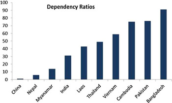
Alongside this economic framing of water resources, nations within the Himalayan region are situated as either “water poor” or “water rich.” Nepal, for example, is considered a “water rich” nation that has significant “untapped potential.” Institutions like the World Bank have encouraged nations to identify potential reservoir sites as part of this harnessing endeavor, with Pakistan alone naming 800 on the Indus River (Sadoff and Harshadeep Reference Sadoff and Harshadeep2011). Asia is, after all, the most “dam-dotted continent,” with more reservoirs holding back its rivers than the rest of the world combined (Chellaney Reference Chellaney2014). Asia's large population means it is the region of the world with the lowest water availability (Le Clue Reference Le Clue2012) and water storage capacity per capita. Figure 4 illustrates the relative importance of negotiating water-sharing agreements based on a country's ability to provide for its water needs within its borders. As the most important upstream country for transboundary water in Asia, China has made few agreements to-date, likely in part due to this control. This also allows China to strategically avoid both cooperation and conflict. India plays a prominent role in South Asian hydro-conflict (Begum Reference Begum1987; Crow and Lindquist Reference Crow and Lindquist1990; Islam Reference Islam1987; Ohlsson Reference Ohlsson1995; Panos Institute South Asia 2004; Swain Reference Swain1996), be it with Nepal, Bangladesh, or Pakistan. For instance, India's decision to build the barrage at Farakka for diversion of water from the Ganga River had adverse impacts on Bangladesh, including degraded surface and groundwater supplies, impeded navigation, declining fisheries, and public health risks (Nishat Reference Nishat, Biswas and Hashimoto1996). While India and Nepal have a history of cooperation in relation to water with a series of agreements dating back to 1954, many Nepalese adamantly believe that the treaties are unequal and biased toward India (Price et al. Reference Price2014).
Dependency ratios for South and East Asian countries—the extent to which a country depends on external water resources (Le Clue Reference Le Clue2012).

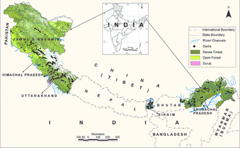
Throughout High Asia, cross-border conflicts over international water rights have recently led to increased geopolitical tensions (Heath et al. Reference Heath, Manton and Stevenson2014). China's damming and diversion of transboundary rivers could have a severe impact on up to two billion people downstream from Tibet, including the rest of China, and could adversely affect the environment, especially with respect to water-intensive cultivation (Buckley Reference Buckley2015). Large dams are also being planned in India, Pakistan, Tibet, Nepal, and Bhutan. India alone has plans to build 292 dams (Pandit and Grumbine Reference Pandit and Grumbine2012; see figure 5), and is expediting environmental reviews of dam projects in order to ensure “prior appropriation” rights before downstream neighbors—Pakistan on the Indus River and Bangladesh on the Brahmaputra—move forward with dams of their own (Hennig Reference Hennig and Samadi-Boroujeni2012). This creates a scenario where water resources are not able to be optimized for any country, and the potential for conflict over water is heightened (Grumbine and Pandit Reference Grumbine and Pandit2013).
Distribution and density of planned dams, forest cover, and rivers across the Indian Himalaya (Pandit and Grumbine Reference Pandit and Grumbine2012).

In Central Asia, Tajikistan and Kyrgyzstan hold the headwaters for the Amu Darya and Syr Darya rivers, respectively. The Rogun Dam, planned for installation on a tributary of the Amu Darya as the world's tallest dam, would provide Tajikistan with control of 3.6 gigawatts of electrical output capacity to use domestically and to export regionally. For the years it takes to fill the reservoir behind the 335-meter-tall dam, downstream Turkmenistan and Uzbekistan would be deprived of water currently contributing to Amu Darya discharge. Kyrgyzstan is planning a similar mega-engineering project: the 275-meter-tall Kambarata Dam on a Syr Darya tributary with 2.0 gigawatts of generating capacity. Uzbekistan, downstream of both projects, has raised vocal opposition to the works, and Uzbek President Islam Karimov has suggested that the decrease in water supply due to dam construction could trigger violent conflict (Economist 2014). These transformations in water use and allocation will profoundly affect the quality of life, economic vitality, environment, and regional stability of Central Asia in the coming decades.
Such strategic positioning of dams across the landscape allows for a redistribution of water resources to less-endowed nations through what Zeitoun and Warner (Reference Zeitoun and Warner2006) call “resource capture strategies.” However, in order to accomplish this without conflict or resistance over inequitable utilization patterns (Chellaney Reference Chellaney2014), dams must be explicitly situated as “technical” rather than “politically infused” solutions. Drawing on narratives of water crisis that frame dams as the regional solution to an impending emergency (Biba Reference Biba2014), certain political agendas and development interventions can be elevated above critique or responsibility to social and environmental justice. In this way, critics’ concerns are silenced and resistance to otherwise controversial forms of development is curtailed, while “maintaining a form of hegemonic thought control” (Zeitoun and Warner Reference Zeitoun and Warner2006). The situation in Central Asia blurs this line, as technical solutions for one country create politically charged situations with neighboring countries.
Research from Oregon State University's Transboundary Freshwater Dispute Database shows more than two-thirds of documented water-related “events” worldwide since 1820 are cooperative in nature, not conflictual, and a majority of conflictual “events” are described as mild (Zeitoun and Mirumachi Reference Zeitoun and Mirumachi2008). So will water scarcity lead to conflict? The context of water “events” is changing due to population growth, changing patterns of economic growth, and more complex resource challenges (National Research Council 2012). Major water conflicts to-date have been related to source disputes, sharing of drinking water and water for irrigation, and payment of compensation of damages caused by the construction of water-related projects, especially in the dry season when people use water for diverse purposes. Between 2010 and 2012, seven episodes of violence leading to more than 219 deaths in India and Pakistan have been attributed to disputes over water resources (Gleick and Heberger Reference Gleick, Heberger and Gleick2014). These disputes were all rooted in allocation of water, and only one incident was tied to transboundary rights between the two countries. Thus, national and even local policies for guiding the just allocation of water can be as important as international policies for protecting human safety and security.
The great potential for storage of water in High Asia with dams and reservoirs could mute the amplitude of the annual hydrograph and provide a buffer against flooding and droughts. Reservoirs may also provide substantial hydropower benefits and support industrialization in the region through clean energy, and deliver other socioeconomic and environmental benefits (Vaidya et al. Reference Vaidya, Eriksson, Bhandari and Ouyang2010). However, forthcoming progress on transboundary water issues in the Indus basin seems likely to depend more on relations between the four countries that share it than on natural variability (Hewitt Reference Hewitt2014).
Different strategies have been adopted to mitigate transboundary conflicts. For example, active participation of local users in decisions related to water allocation and community services have encouraged reciprocity and cooperation at the community level (Vaidya Reference Vaidya2015). On a broader scale, the countries through which the Kosi River passes require an integrated approach to optimize water resources and mitigate water-related hazards. However, in the context of transboundary basins, a policy adopted upstream could generate either positive or negative externalities downstream. Ultimately, any insistence on a regional, multi-basin approach to integrative water governance explicitly depoliticizes the charged nature of transboundary water relations and obscures the deferential power dynamics between nations with more political leverage, like India, who are largely dependent on water-wealthy neighbors such as Nepal and Bhutan.
Finding a Balance
If given the chance, localized strategies for more justly managing and allocating water resources could be rooted in cultural values, but political and economic interests often usurp that opportunity. In Nepalese society, people understand water as a public good, contrary to state law that allows private ownership of water resources. In Nepal, construction of hydro megaprojects are often linked with corruption and malpractice (Upreti Reference Upreti2004). In domestic water management, there may also be a lack of coordination, as the approaches and priorities of different ministries or provinces frequently conflict (Price et al. Reference Price2014). This signifies the complexity that encompasses internal water management issues (Mukherji Reference Mukherji2006), let alone regional coordination beyond nations.
Water can be an entry point for addressing challenges common to the region, particularly through multipurpose river projects that store monsoon water, mitigate the effects of floods and potential droughts (Dash et al. Reference Dash, Rafiuddin, Khanam and Islam2012), augment dry season river flows, expand irrigation and navigation facilities, generate hydropower, and enhance energy and environmental security. Cooperation is needed to cope with natural disasters such as floods and other catastrophes not confined by political boundaries. While floods are inevitable, the damage can be reduced through the joint efforts of countries sharing real-time hydrometeorological data. Despite a number of initiatives made by the International Centre for Integrated Mountain Development (ICIMOD) and the South Asian Association for Regional Cooperation, real-time data sharing among the South Asian countries remains limited (Thakkar Reference Thakkar2006). Billions of dollars could be saved by regional cooperation in flood mitigation (Ahmand Reference Ahmand, Biswas, Ünver and Tortajada2004). For instance, ICIMOD has been successfully working with national partners in China, India, Nepal, and Pakistan since 2008 to document, assess, and—over the long term—strengthen local adaptation strategies to flood and drought in and downstream from mountain catchments (Pradhan et al. Reference Pradhan2012). Local and regional institutions will continue to play a significant role in coordinating issues regarding water conflicts, transboundary sharing of water, and effective cooperation for optimizing benefits from regional resources (Tiwari and Joshi Reference Tiwari and Joshi2014).
Conclusions
To plan for management and mitigation of the looming threats to Asia's water supplies requires an assessment of present impacts and a projection of future changes to these resources. A wide range of estimates exist today that attempt to quantify the volume of water that melting glaciers contribute to low-elevation water resources. Recent investigations show that the role of melting ice is less than previously believed, but have reiterated the need to separate contributions of melting glacier ice from contributions of melting snow. Remote sensing has revolutionized our view of the world, expanded our understanding of earth system processes, and is fundamental to ongoing monitoring of the cryosphere. Yet it too has its limits and must be combined with other methods to ensure more accurate representation of the complex realities on the ground. Thus, in conjunction with more robust ground-based measurements, we are moving toward an understanding of the changes taking place in these systems, particularly the reduction in ice area, ice mass, and snow cover.
Remote sensing has also proved invaluable in mapping glacial lake hazards, which can be mitigated through engineering efforts. Landslide hazards and associated flood risks are more difficult to predict and are a potentially growing threat if precipitation amounts increase with climate change. Risk reduction activities in mountain communities are largely limited to relocating from unstable slopes and out of flood plains, efforts that have not been widespread to-date, particularly in cases where there is limited government assistance. The nations of High Asia are exploring untapped hydropower potential, primarily on transboundary rivers. The seemingly unstoppable push to develop dams will provide power to millions, but political leaders must choose to navigate the resource development in mutually beneficial ways. The potential for conflict exists, with Central Asia being an area to watch in the near term. Stress on water resources would exacerbate this threat over time.
In addressing collective problems of the scales of climate change, population growth, economic development, and growing demands on resources, policy and research must go hand in hand to create viable solutions and mitigate vulnerability to water scarcity. In some ways, Asia is well positioned to plan for such changes. While drought is possible and extreme precipitation events can be disastrous, the South Asian monsoon is a consistent source of annual precipitation. There is potential for this water to be harnessed for hydropower and stored for agricultural, municipal, and industrial uses throughout the year.
Ultimately, changes to the cryosphere discussed here cannot be controlled on time scales meaningful to a single generation of people. Therefore, water security must be pursued via adaptation strategies: part of this will involve negotiations over storage capacity and how to effectively capture earlier peak discharge, more balanced management of surface water and groundwater resources, and negotiated transboundary water management. Prioritizing interdisciplinary assessments can incorporate social and economic factors with the impacts of climate change into future hydrologic modeling and offer a way forward for conversations between researchers and decision-makers about adaptation measures.
Interdisciplinary investigations are called for, as well as the engagement of stakeholders in water resources planning. Water security for Asia is possible, but will require adaptation to climate change and an approach that allows water resources to be equitably shared.
At the same time, the specific ways in which climate change will play out over time are rich with uncertainty. Even as science has asked more questions in the region regarding how water cycles through glaciers, snow, ice, and precipitation, the answers uncovered point to dramatic variability and additional factors that have not been accounted for. In some places, water scarcity does not currently and may never exist. Yet, powerful voices repeat a narrative of crisis across High Asia: the environment is being degraded, the glaciers are disappearing, and the populations depending on these critical water resources are growing exponentially. Climate change may usher in the first major war over water. Yet the battle already being fought, though in many ways invisibly, is over who has the power to manage Asia's greatest rivers and what the solutions are to a constantly evolving human relationship with water in High Asia.
Acknowledgments
Funding was provided by the US Agency for International Development to the Contribution to High Asia Runoff from Ice and Snow (CHARIS) project and National Science Foundation (NSF) support of the Niwot Long Term Ecological Research project. Alana Wilson's work and contribution are supported by a NASA Earth and Space Science Fellowship. Sierra Gladfelter's work and contribution are supported by the NSF Graduate Research Fellowship under Grant No. DGE 1144083. Sonika Shahi and Prashant Baral have been supported in part by ICIMOD.