1. INTRODUCTION
The phenomenon of globalisation, together with developments in economics and technology, has had a great influence on many fields including world trade. This has caused an increase in world trade volume and correspondingly, an increase in marine transportation volumes. The Istanbul Strait has a strategic importance for the Caucasian-Caspian basin and countries having a Black Sea coastline. They bind the Aegean, Marmara and Black Sea together and for the aspect of marine transportation, have geopolitical importance and traffic density that makes them some of the most important sea corridors in the world.
In contrast to the developments in technology and enacted international safety regulations, marine accidents in the Istanbul Strait still pose a serious problem (Çelik and Çebi, Reference Çelik and Çebi2009). Studies show that, despite precautions, some accidents could not be prevented (Portela, Reference Portela2005). In published research, it is stated that 70%–80% of marine accidents arise from human error (Harrald et al., Reference Harrald, Mazzuchi, Merrick, van Dorp and Spahn1998; Reason, Reference Reason1997; Wang et al., Reference Wang, Pillay, Kwon, Wall and Loughran2005; Portela, Reference Portela2005; Barnett, Reference Barnett2005; Trucco et al., Reference Trucco, Cagno, Ruggeri and Grande2007; Martins and Maturana, Reference Martins and Maturana2010; Başar and Yıldırım, Reference Başar and Yıldırım2014; Yıldırım et al., Reference Yıldırım, Uğurlu and Başar2015; Erol and Başar, Reference Erol and Başar2015; Uğurlu et al., Reference Uğurlu, Erol and Başar2015). Coastal areas, especially passages such as the Istanbul Strait are considered to be the most dangerous marine spaces (Uğurlu et al., Reference Uğurlu, Yıldırım and Yüksekyıldız2013). Marine accidents occurring in coastal areas do great harm to humans, environment and economy (Uğurlu et al., Reference Uğurlu, Erol and Başar2015; Wei et al., Reference Wei, Hu, Dong and Zhao2015; Goerlandt et al., Reference Goerlandt, Montewka, Kuzmin and Kujala2015). Indeed, many parties are directly affected by marine accidents such as the flag state, ship crew, other ships, environment, fishermen, cargo owners, ship owners, class societies, ship construction industry and insurance companies (Poyraz, Reference Poyraz and Ö1998; Erol and Başar, Reference Erol and Başar2015). For the Istanbul Strait, it is necessary to minimise the number of accidents to improve safety and limit damage and cost (Başar, Reference Başar2010).
This paper aims to analyse maritime accidents and to improve safety and reduce the possibility of an unwanted event in the Istanbul Strait. Additionally, results obtained from this study can be an important input for risk assessment. Also, in a risk/ship accident analysis, risk is described from various perspectives (Goerlandt and Montewka, Reference Goerlandt and Montewka2015). In this study the term risk is used as the possibility of an unwanted event. Accident archives of the Turkish Republic's Ministry of Transport, Maritime affairs and Communications and weather condition data from the Turkish State Meteorological Service have been used to prepare the model input and the International Maritime Organization (IMO) definition of accidents has been used to prepare the model output.
The remainder of this paper is organised as follows. The subject and method of study is mentioned together with previously conducted studies in Section 2. In Section 3, brief information is given about the Istanbul Strait. The data set and methods used are defined in Section 4. In Section 5, findings and results are discussed considering the rules generated for marine accidents on the Istanbul Strait. Furthermore, some datasets tested with Artificial Intelligence (AI) methods are summarised in this section. Finally, we conclude by giving a summary of the implementation in Section 5.
2. RELATED WORK
Identifying accident factors in relation to marine accidents may contribute to the solution for lowering the count of accidents that affect many parties. AI methods, such as Artificial Neural Networks (ANN), Adaptive Neuro-Fuzzy Classifier (ANFC), and Genetically Optimised Fuzzy Classifier (GOFC) can be used for analysing marine accidents.
There are some limited studies on marine accidents analysis by AI. Some recent works include the following. Hashemi et al. (Reference Hashemi, Le Blanc, Rucks and Shearry1995) used a neural network for transport safety modelling. Le Blanc et al. (Reference Le Blanc, Hashemi and Rucks2001) carried out accident analysis of over 900 marine accidents that occurred on the lower Mississippi River, using neural computing techniques. Çelik and Çebi (Reference Çelik and Çebi2009) used a human factor analysis and classification system, based on a fuzzy analytical hierarchy process, to identify the role of human errors in shipping accidents. Qu et al. (Reference Qu, Meng and Suyi2011) examined fuzzy ship domains based on a vessel collision risk assessment for the Singapore Strait. Küçükosmanoğlu (Reference Küçükosmanoğlu2012) developed an ANN model and Adaptive Neuro-Fuzzy Inference System (ANFIS) to forecast maritime accidents in the Istanbul Strait. This work defined the critical zones and the collision/capsizing accidents at high intensity zones in the strait. Mentes et al. (Reference Mentes, Akyildiz, Yetkin and Turkoglu2015) identified and evaluated driving factors such as geographical locations at the time of the incident and failure modes causing fatalities for cargo ships using fuzzy set theory in coastal and open sea areas of Turkey.
Cetisli (Reference Cetisli2010a) proposed ANFC, using Linguistic Hedges (LH) which are fuzzy rule-based methods. These methods are used to classify the Istanbul Strait data. LHs improve the fuzzy meaning. The obtained fuzzy rule knowledgebase can easily be interpreted and shows the relation between input and output variables. To determine a proper maritime accident type, there are not enough data for some accident types such as machinery damage. Therefore, the number of samples in some accident types is very low. This situation affects the classification success. To eliminate this problem, the “Give&Take” validation method was also used. The Give&Take method creates two similar datasets from all the data (Cetisli and Kalkan, Reference Cetisli and Kalkan2014). The effects of the features of the accident type determination were also analysed in this study.
There are also studies on marine accidents analysis on the Istanbul Strait, but the early work is somewhat limited. Akten (Reference Akten2004) reviewed 461 marine accident reports for accidents that occurred in the Istanbul Strait between the years 1953 and 2002. He organised the accidents by accident type and identified those sea areas that had the highest accident incident rates. Kum et al. (Reference Kum, Furusho and Iwasaki2008) investigated the risk profile of maritime accidents in the Istanbul Strait and then developed a methodology to minimise human error. Arslan and Turan (Reference Arslan and Turan2009) examined the factors that influenced the occurrence of marine accidents in the Istanbul Strait. Ulusçu et al. (Reference Ulusçu, Özbaş, Altıok and Or2009) analysed safety risks pertaining to transit vessel maritime traffic in the Istanbul Strait and proposed ways to mitigate marine accidents. Yazici and Otay (Reference Yazici and Otay2009) developed a real time maritime traffic support model for safe navigation in the Istanbul Strait using a new MATLAB code. They concluded that local traffic density and pilotage turned out to be two main factors affecting the risks in the Istanbul Strait. Aydogdu et al. (Reference Aydogdu, Yurtoren, Kum and Park2010) designated the most hazardous areas and identified the dangers regarding vessel traffic in the southern entrance to the Istanbul Strait. Erol and Başar (Reference Erol and Başar2015) analysed safety of life and economic loss in marine accidents occurring in the Turkish Straits using decision trees. Uğurlu et al. (Reference Uğurlu, Erol and Başar2015) focused on marine accidents in the Turkish Straits that did serious harm to humans, the natural environment, and the economy.
3. ISTANBUL STRAIT
Istanbul is the only city in the world that stands astride two continents and is without any alternative waterway. Therefore, the Istanbul Strait, the narrow waterway separating Europe from Asia, holds a strategic importance in maritime transportation as it links the Black Sea to the Mediterranean and the open ocean beyond. It is a vital passageway not just for trade but for the projection of military and political power (Ulusçu et al., Reference Ulusçu, Özbaş, Altıok and Or2009; Ucan and Nas, Reference Ucan and Nas2016).
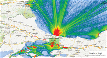
The Istanbul Strait is distinct among the waterways of the world in its geographical structure and oceanographic characteristics. It is an approximately 30 km long, geographically narrow sea corridor which has sharp turns. Its mean width is 1,500 m and its narrowest place is the Kandilli region at 696 m. In the shallowest area, depth is 19 m. There are a total of 12 sharp turns throughout the strait and the sharpest turn is Yeniköy at 800. Deep and surface currents that rise to 6–8 knots from time to time significantly affect navigation safety. Traffic density of the Istanbul Strait is presented in Figure 1.
Traffic density of Istanbul Strait (Marine Traffic, 2016).

There is a two layered current pattern in the strait. The current from the Black Sea to the Marmara Sea flows on the surface and Mediterranean water flows from the Marmara Sea to the Black Sea at the bottom of the strait. Sometimes, the reverse currents can also be seen on the surface (Küçükosmanoğlu, Reference Küçükosmanoğlu2012). In addition to the geographical, physical and oceanographic structure of the strait; traffic density, dangerous cargo transportation, increasing ship lengths, complicated traffic system, sensitive environmental conditions, local dangers, the other activities affecting ship traffic, rising sea accidents, port configuration and bridges are also issues that have an influence on safe navigation throughout the Istanbul Strait (Uğurlu et al., Reference Uğurlu, Erol and Başar2015). Thus, the Istanbul Strait is considered to be one of the world's most dangerous waterways to navigate. Over 50,000 transit vessels pass through the Strait annually, 20% of which carry dangerous cargo (Ulusçu et al., Reference Ulusçu, Özbaş, Altıok and Or2008).
The legal framework of the transit traffic through the Strait of Istanbul is governed by the 1936 Montreux Convention. The vessels in question shall not be required to make any other stop during their passage through the Strait and pilotage and towage remains optional (Montreux Convention, 1936. Article 3–4). Accidents during oil transportation in the Strait, in particular, threaten serious ecological problems and impacts on people in Istanbul. Due to these problems, Turkey introduced traffic separation schemes in 1994, which were reorganised in 1998 and named Maritime Traffic Regulations for the Turkish Straits (MTRTS), to enhance safety of navigation (MTRTS, 1998).
4. MATERIAL AND METHODS
This section first defines the data set used in the study and then explains the methods which depend on artificial intelligence.
4.1. Data Set
In this study, maritime accident data has been taken from the accident archives of the Ministry of Transport, Maritime and Communications Search and Rescue Department of the Turkish Republic (MTMC-SRD). The accident data includes information about ships’ names, flags, types and tonnage, coordinates of accidents, reasons for accidents, results of accidents, size of accidents, time of accidents (if available) and impact of accidents to the crew and economy. Weather condition data has been taken from the Kireçburnu, Kumköy and Göztepe stations of the Turkish State Meteorological Service (TSMS). All data are registered and official. The basic parameters used for the analysis are also Gross Registered Tonnage (GRT), ship Length Overall (LOA), Sea Wave Height (LW) and Daily Average Wind Speed (DAWS). All of them are quantitative. According to the data set, although 880 marine accidents were recorded between 2001 and 2015, only 135 marine accidents matched with weather conditions data are used. This is because the majority of these accidents are very minor marine incidents.
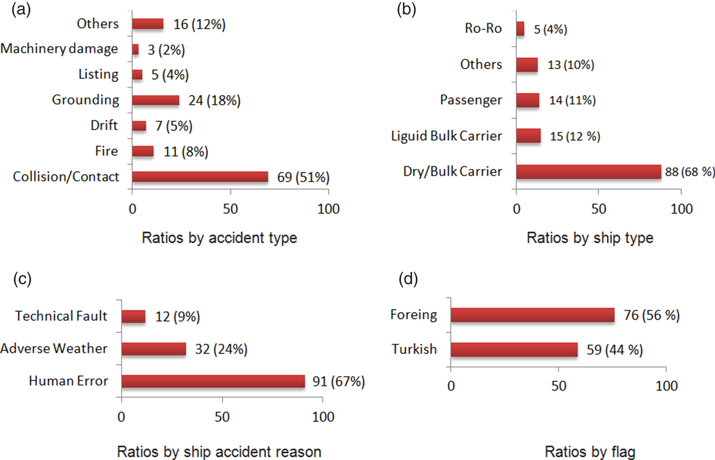
Marine accident data has four ratings for accidents which are ‘Less Serious’, ‘Serious’, ‘Very Serious’ and ‘Marine Incident’. Marine accident data used in the chart are grouped according to accident type, accident reason, ship type, and ship flag. The descriptive statistics of the data are given in Figure 2.
Descriptive statistics of the marine accident data.

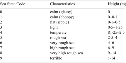
According to the Turkish State Meteorological Service, winds that have a velocity between 10·8 m/s and 17·1 m/s are considered ‘strong winds’ and winds that have a velocity of more than 17·2 m/s are considered ‘gale’. The descriptive lengths of waves are given in Table 1.
Description of height of accidents according to TSMS.

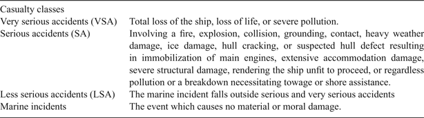
The analysed marine accidents have been classified by the IMO's identification indicated in Table 2.
Severities of accidents according to IMO (MSC-MEPC.3/Circ. 1).

According to the IMO, the severities of accidents are based on the three-level categorisation. This categorisation depends on the impact of an event (accident) on people, property and environment (Valdez Banda et al., Reference Valdez Banda, Goerlandt, Montewka and Kujala2015).
4.2. Classifiers
Artificial Intelligence (AI) is a major discipline that includes sub-disciplines such as fuzzy logic, artificial neural networks, genetic algorithms, particle swarm optimisation, etc. There are several fields to apply these methods such as classification and regression. In this paper some AI techniques are used for classifying accident data.
Every method has advantages and disadvantages. To reduce the disadvantages, some of these algorithms are merged to achieve new methods. In this paper, we used neuro-fuzzy classifiers (Adaptive Neuro-Fuzzy Classifier (ANFC), Adaptive Neuro-Fuzzy Classifier Using Linguistic Hedges (ANFC-LH)) which are the combinations of fuzzy logic and artificial neural networks, and Genetically Optimised Fuzzy Classifier (GOFC) and compared the yields with Artificial Neural Networks (ANN).
In this study, only AI-based methods are used due to insufficient samples for some accident types. Therefore, the statistical or stochastic classifiers were not used. The ANFC-LH and GOFC methods are initially used to classify sea accidents.
4.2.1. Adaptive Neuro-Fuzzy Classifier
Fuzzy Inference Systems (FISs) are the closest method to human thinking. ANNs have learning capabilities. When a problem is modelled with FIS, the FIS parameters can be adapted by ANN training approximation. The ANFC combines FIS and ANN methods. Jang (Reference Jang1993) proposed ANFIS as an approximation function and estimator. ANFIS has only one output. Network-based classifiers should have more than one output. However, many researchers have wrongly used the ANFIS as a classifier. Jang also proposed Adaptive Neuro-Fuzzy Classifiers. Cetisli and Barkana (Reference Cetisli and Barkana2010) realised the ANFC using a Scaled Conjugate Gradient (SCG) training algorithm for classification purposes. In neuro-fuzzy classification methods, the feature space is partitioned into multiple fuzzy subspaces that are controlled by fuzzy if-then rules. These rules can be represented by a network structure. However, to determine an optimum fuzzy region, the parameters of the fuzzy rules should be optimised (Jang, Reference Jang1993; Cetisli and Barkana, Reference Cetisli and Barkana2010). This classifier has both multiple inputs and outputs. The use of weights in the defuzzification step affects the rules and improves the classification flexibility. The K-means clustering method is used to obtain the initial parameters and to formulate the fuzzy if-then rules (Jang et al., Reference Jang, Sun and Mizutani1997; Cetisli, Reference Cetisli2010b).
A fuzzy classification rule R i which describes the relation between the input feature space and the classes can be defined as follows:
 $$R_{i}: \hbox{IF}x_{s1}\ is\ A_{i1}\hbox{AND}\ldots x_{sj}\ is\ A_{ij}\hbox{AND}\ldots x_{sn}\ is\ A_{in}\hbox{THEN } class \,\hbox{is }C_{k},$$
where x sj denotes the j th feature or input variable of the s th sample; C k represents the k th label of class; n represents the number of features; A ij denotes the fuzzy set of the j th feature in the i th rule and is characterised by the appropriate membership function (Jang et al., Reference Jang, Sun and Mizutani1997).
4.2.2. Adaptive Neuro-Fuzzy Classifier Using Linguistic Hedges
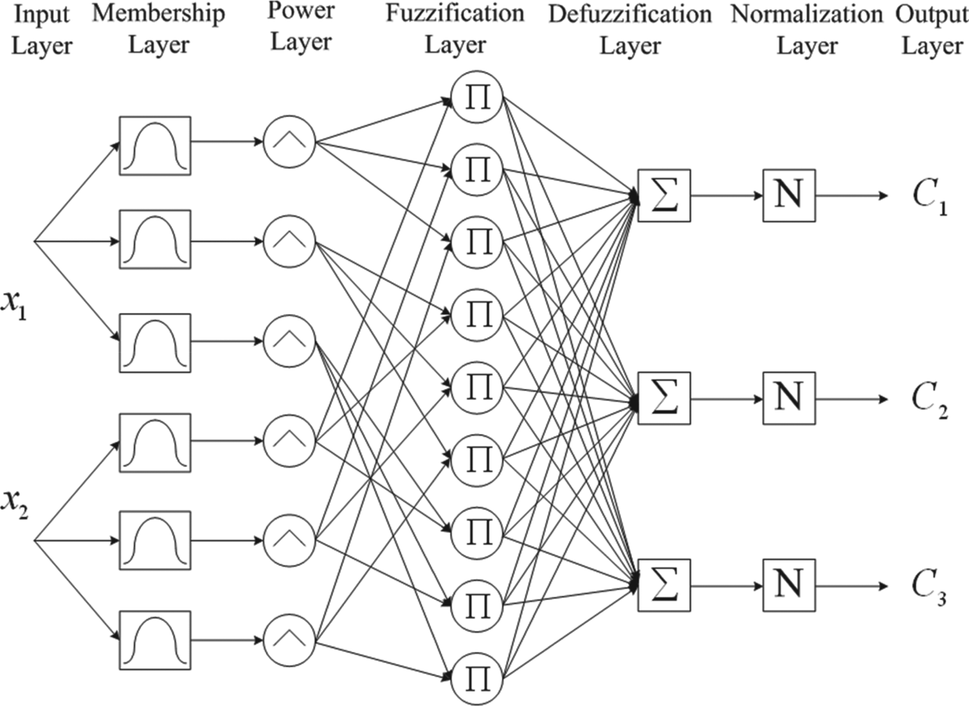
In the ANFC-LH method, the LHs that are constituted by the power of fuzzy sets introduce the importance of the fuzzy sets for fuzzy rules (Cetisli, Reference Cetisli2010b). They can also change the primary meaning of fuzzy membership functions to a secondary meaning. To improve the meaning of fuzzy rules and classification accuracy, a layer, which defines the adaptive linguistic hedges, is added into the proposed classifier network. The LHs are trained with other network parameters by an SCG training algorithm. The tuned LH values of fuzzy sets improve the flexibility of fuzzy sets. This property of LH can improve the distinguishability rates of overlapped classes. Linguistic hedges improve the meaning of linguistic variables and terms.
When the fuzzy rule is redefined with LHs, the new rule occurs as:
 $$\eqalign{R_{i}&:\hbox{IF}x_{s1}\ is\ A_{i1}\ \hbox{with}\ p_{i1}\ \hbox{AND}\ldots x_{pj}\ is\ A_{ij}\ with\ p_{ij}\hbox{AND}\ldots \cr&x_{pn}\ is\ A_{in}\ with\ p_{in}\ \hbox{THEN}\ class\ \hbox{is}\ C_{k}}$$
When the p ij value is equal to 0 value, the A ij fuzzy set is not used. By this way, the rule is shortened. This result can be used for feature selection (Cetisli, Reference Cetisli2010a). The structure of the ANFC-LH method is described in Figure 3.
Structure of ANFC-LH Method (Cetisli, Reference Cetisli2010a).

4.2.3. Feature Selection Using ANFC-LH
This paper presents a fuzzy Feature Selection (FS) method based on the LH concept. The values of LHs can be used to show the importance degree of fuzzy sets. When this property is used for classification problems, and every class is defined by a fuzzy classification rule, the LHs of every fuzzy set denote the importance degree of input features (Cetisli, Reference Cetisli2010a). If the LHs values of features are close to concentration values, these features are more important or relevant, and can be selected. In contrast, if the LH values of features are close to dilation values, these features are not important, and can be eliminated. According to the LHs value of features, the redundant, noisy features can be eliminated, and significant features can be selected. For this aim, a new LH-based FS algorithm is proposed by using ANFC.
4.2.4. Artificial Neural Networks
In machine learning and AI, ANN is a popular model inspired by biological neural networks and is used to estimate approximate functions or in classification. Artificial neural networks are generally presented as a system of interconnected neurons which move messages between each other. The connections have numeric weights that can be tuned based on experience, making neural nets adaptive to inputs and capable of teaching (Bishop, Reference Bishop1995).
ANNs are generally made up of three layers: the input, hidden, and output layers. The input layer receives the initial values of the variables, the output layer shows the results of the network for the input, and the hidden layer carries out the operations designed to achieve the output. The number of neurons in the input layer must correspond to the number of input variables, and the output layer must have as many neurons as the number of outputs produced by the network. However, there is no rule to allow prior decisions to be made on the number of neurons the hidden layer should contain or whether the hidden layer must consist of more than one sub-layer. The hidden layer is obtained through trial and error.
Neural computation based on artificial neural networks involves database training to predict the input of the initial values of the variables, while the output layer shows the results of the network for two-dimensional problems, because it is able to imitate the learning capability of human beings. Thus, the network learns directly from the examples without any prior formula regarding the nature of the problem and can independently generalise knowledge, which then can be applied to new cases (Wang et al., Reference Wang, Zeng and Chen2015). In this paper a feed-forward back propagation neural network is used as the ANN model.
4.2.5. Genetically Rule Extracted Fuzzy Inference System
Another approach for FIS generation according to dataset is genetic fuzzy systems, and many methods and algorithms have been reported (Herrera, Reference Herrera2008). In this study, to generate a Sugeno-Typed FIS (Takagi and Sugeno, Reference Takagi and Sugeno1985), a method composed of three stages is followed. In the first stage, fuzzy inputs and outputs are generated according to a training dataset. In the second stage, fuzzy rules are generated according to the dataset via the genetic algorithm approach and in the last stage the numbers of these rules are also reduced via genetic algorithm.
According to this algorithm; cluster size, training dataset and genetic algorithm parameters (chromosome number, crossover and mutation ratios etc.) are received from users. Each feature vector in a dataset is clustered by a fuzzy c-means algorithm. Each cluster centre is signed as a Gauss-typed membership function's centre. Functions are enlarged until the function covers a defined percentage of data. So the first stage of the algorithm is completed and fuzzy inputs and output are generated.
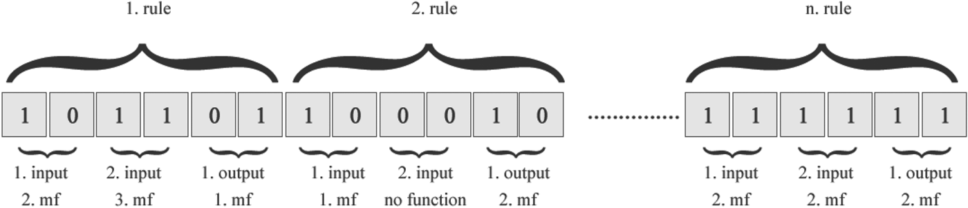
In the second stage the first task is defining the chromosome structure. Every rule is represented as an array of integers. Each item of the array describes the order of membership functions in the fuzzy input or output. As every fuzzy input has membership functions according to cluster number, cluster number is binarized and digit number is achieved and every membership function is represented by bits. With merging binarization rules, a chromosome is generated. In Figure 4, a sample chromosome structure is shown for FIS which has three inputs, one output, n rules and three clusters. Because cluster number 3 is equal to (11)2 every membership function is represented by two bits.
Chromosome Structure of GOFC.

After the chromosome structure is designed, the fitness function takes an important place in this method. In this paper, mean square error is used as a fitness function. For a fitness result, the chromosome is converted to a rule set and a new rule set is applied for all examples in the training dataset. FIS results are compared with real example values and mean squared error is measured.
The last stage of the algorithm is the rule reduction stage. The chromosome structure of this stage is simpler than this previous stage. Every rule is represented by one bit in the chromosome. If a n. bit takes value 0 this means the n. rule will be removed from the rule set. Like the previous stage, mean squared error is used as the fitness function.
4.2.6. Give&Take Cross-Validation
AI-based methods need training to map input-output data. Therefore, the training and testing data are obtained from the original data. If the behaviours of training and testing data are not similar, the adapted model cannot be classified or approximated to the testing data. To avoid this problem, k-fold cross-validation methods are used for the evaluation of models. In k-fold cross-validation, the folds are created randomly. Therefore there is no similarity between training and testing data. Cetisli and Kalkan (Reference Cetisli and Kalkan2014) proposed a new validation method to satisfy similarity. The Give&Take Cross-Validation (GTCV) is inspired from street games (Cetisli and Kalkan, Reference Cetisli and Kalkan2014). In mutual games, the teams should be in equilibrium. So, the team members are selected for neighbourliness values. All data are matched as couples according their neighbourliness values. While one of the couple is put in the training set, the other is put in the testing set. By this way, two similar and balanced groups are obtained.
5. EXPERIMENTAL STUDIES AND DISCUSSION
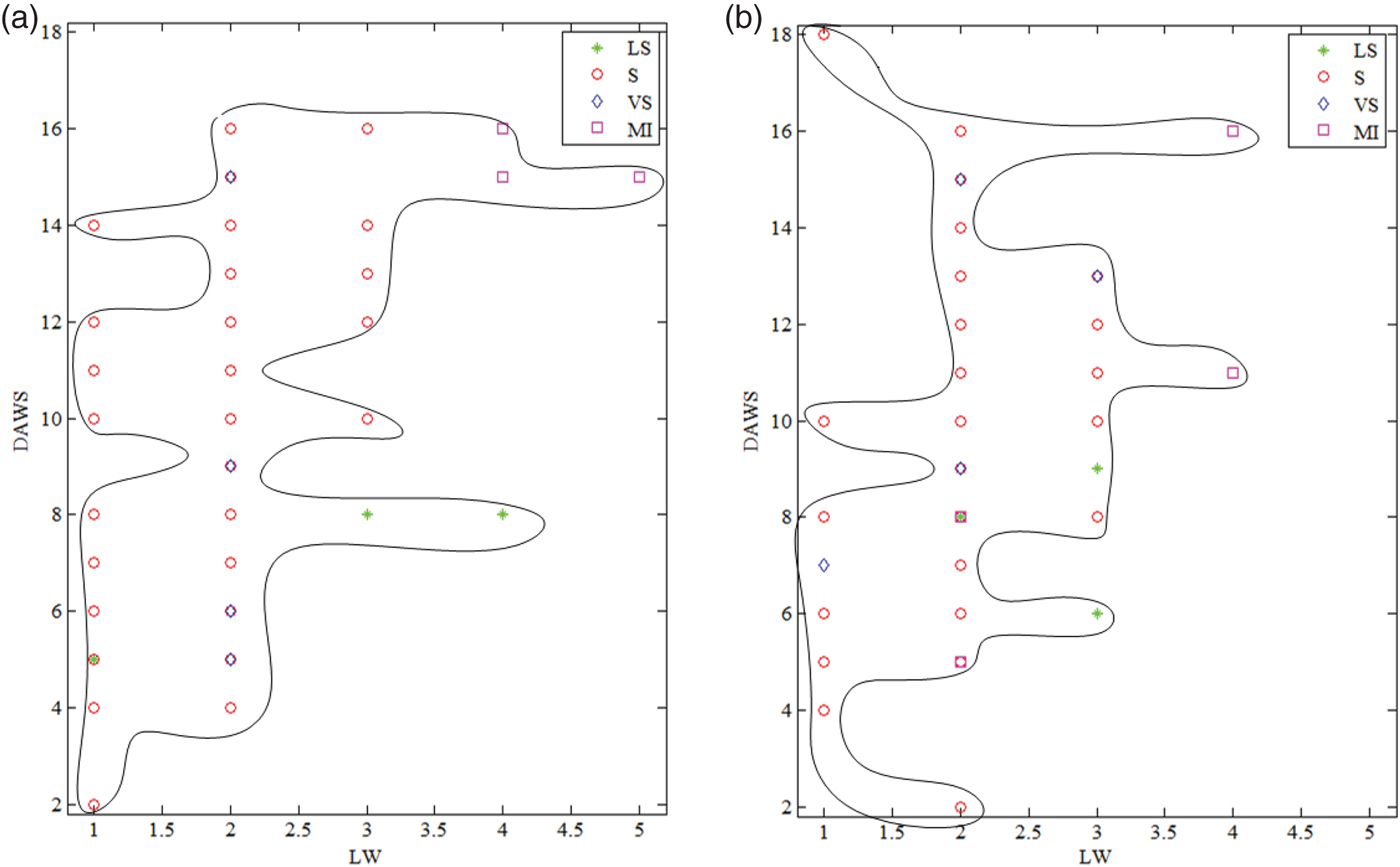
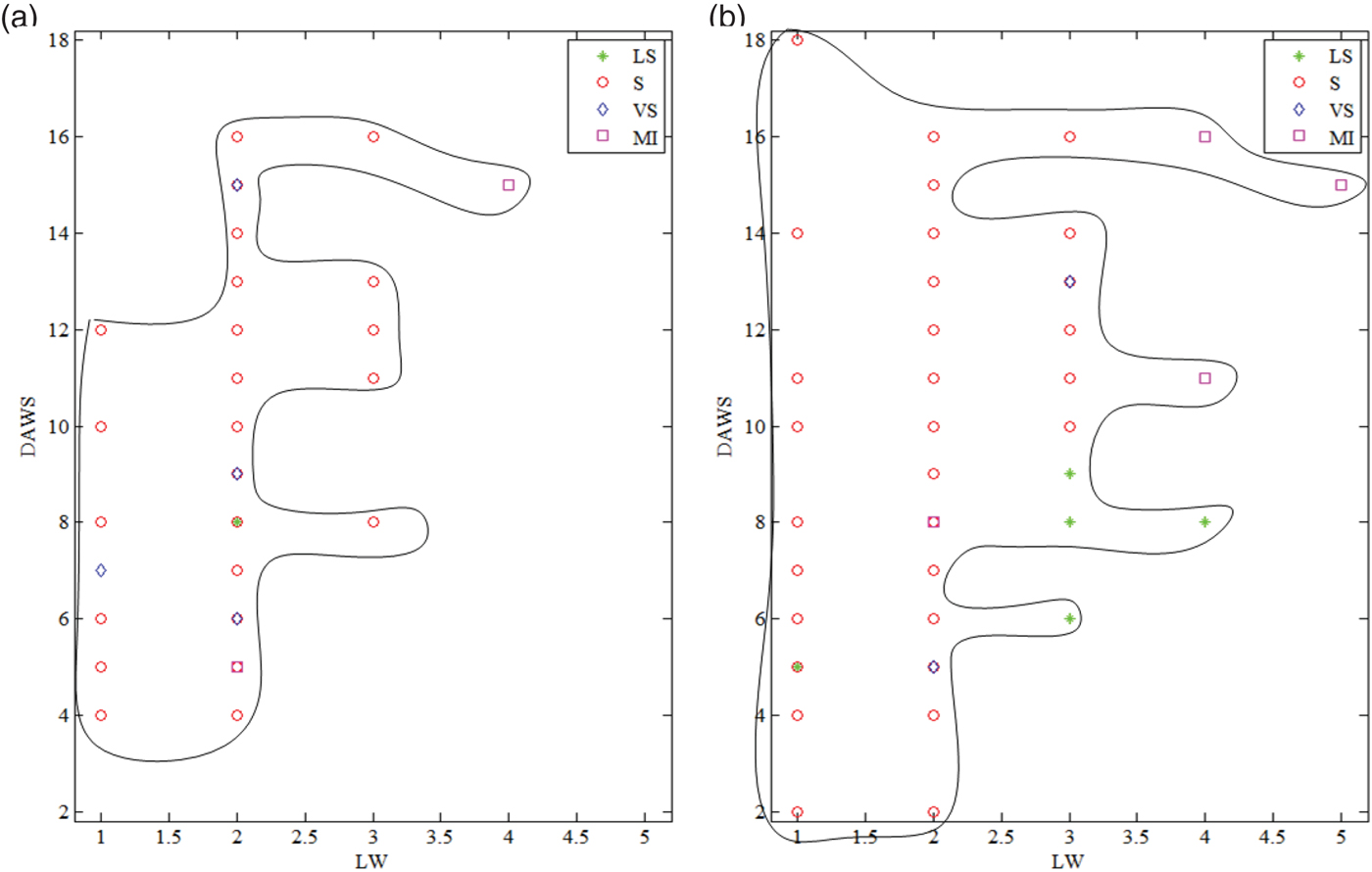
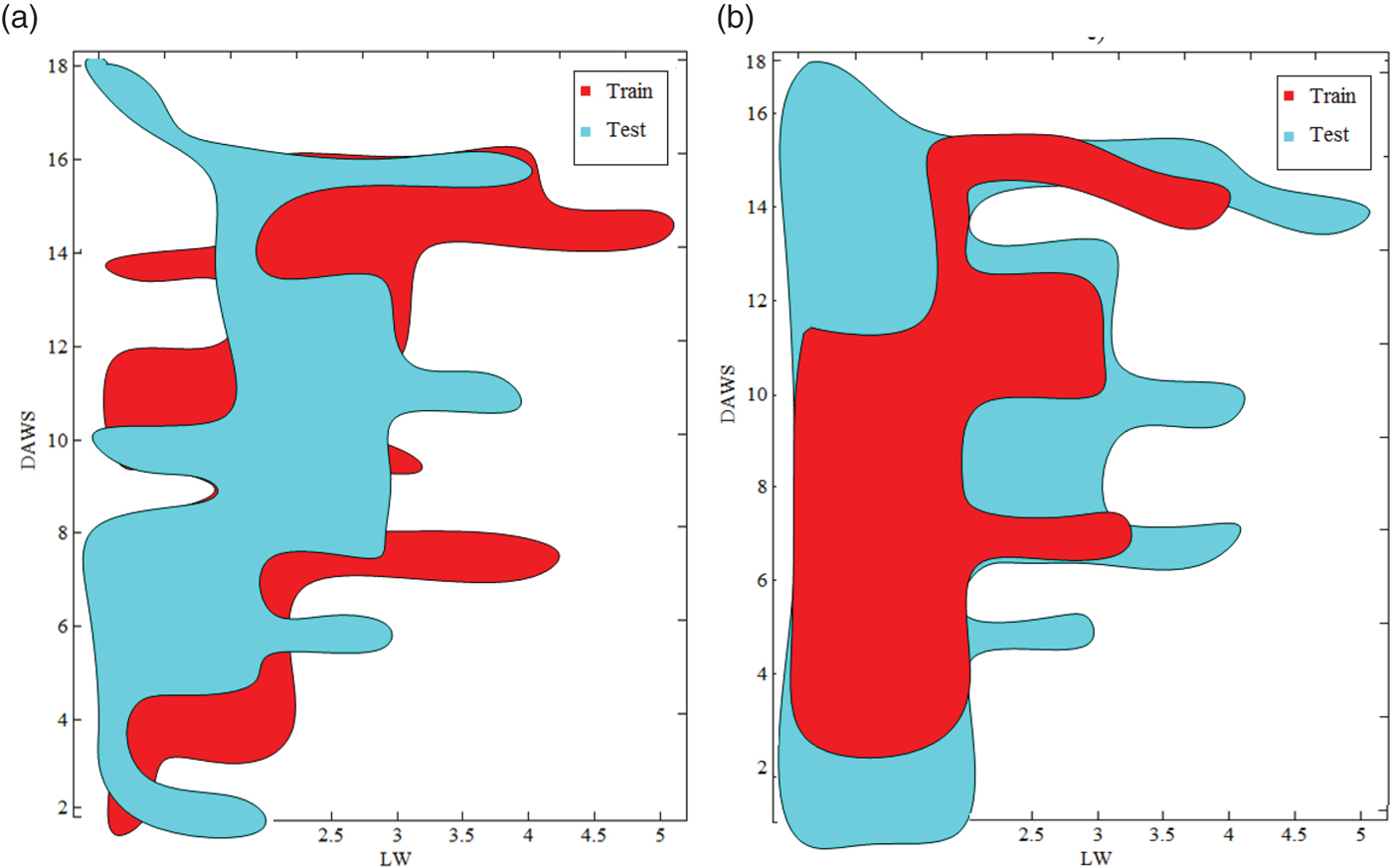
The existing 135 samples are separated into two datasets, 68 of them as training and 67 of them as testing using the GTCV method. The difference between Random Selection (RS) and GTCV are demonstrated in Figure 5. The first column denotes the training sets, the second column denotes the testing sets. The last column denotes the overlapping of sets in Figure 6. The rows denote GTCV and RS, respectively. Figure 7 shows that the overlapping rate of GTCV is better than RS. This result improves the recognition success. ANFC, ANFC-LH, ANN, and GOFC are adapted using the training dataset. The test data is used for checking the success of the trained methods.
Training and Testing of GTCV (a) Training of GTCV, (b) Testing of GTCV.

Training and Testing of RS (a) Training of RS, (b) Testing of RS.

Overlap of GTCV and RS (a) Overlap of GTCV (b) Overlapping of RS.

As shown in Figure 7, sometimes, RS can create a smaller training region than the testing area. Therefore, testing accuracy can be decreased by methods that are trained with this training data. This situation is not wanted. The GTCV technique eliminates this situation and it guarantees the high rate of set overlap.
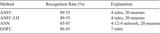
The classification results of methods for testing set of maritime accident data were compared and the results are given in Table 3. The results were obtained with the GTCV method.
Classification results of maritime accident testing data with GTCV.

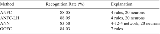
According to Table 3, ANFC, ANFC-LH and GOFC give similar results, but ANFC and ANFC-LH used fewer parameters than GOFC. This study was also repeated for RS of the training and testing sets. The experimental results denote the average values of running the classification results ten times. Table 4 represents the classification results of compared methods using random selection.
Classification results of maritime accident testing data with RS.

Table 4 shows that the recognition rates of methods are decreased if RS is used to create training and testing sets. As a result, GTCV achieves a positive contribution to classification results.
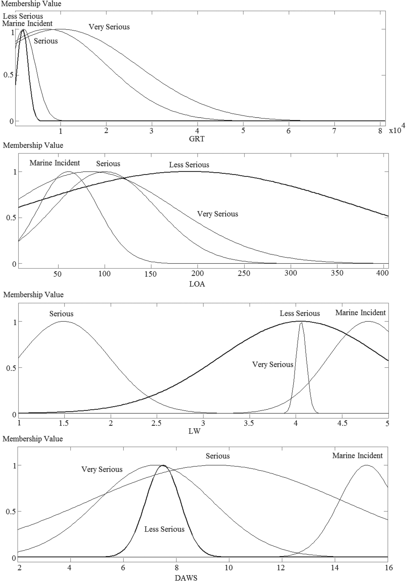
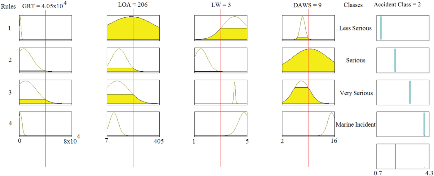
The fuzzy membership functions for four features and four classes are plotted in Figure 8. There are four rules for four classes and they are also depicted in Figure 9 for any random sample.
Fuzzy membership functions of inputs.

Demonstration of fuzzy rules working for any input sample of ANFC.

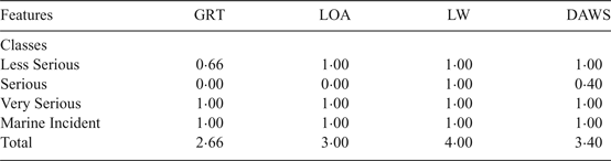
If Figure 9 is analysed, the GRT and LOA features conflict for some accident types with overlapping membership functions. In this figure, the fuzzy inference processes is demonstrated. The red vertical lines represent the inputs. The points of interceptions of inputs and membership functions are filled in yellow (fuzzifying inputs). For every four rules, results are shown by vertical grey lines (applying the fuzzy operator). The last process aggregates all outputs and the defuzzifying. The short red line in the bottom right of the figure represents the result of fuzzy inference. This result is also seen with linguistic hedge values of class membership functions in Table 5 below.
Linguistic Hedge values of class membership functions.

Table 5 shows that the gross registered tonnage is not as important in detecting the accident type as other features. The sea wave height and daily average wind speed are more important than others. As a result, the natural conditions affect accidents more in the Istanbul Strait. So with removing the GRT several experiments are made. For every classifier the best results and features are given in Table 6.
Best Classification results of maritime accident testing data with LW, LOA and DAWS features.

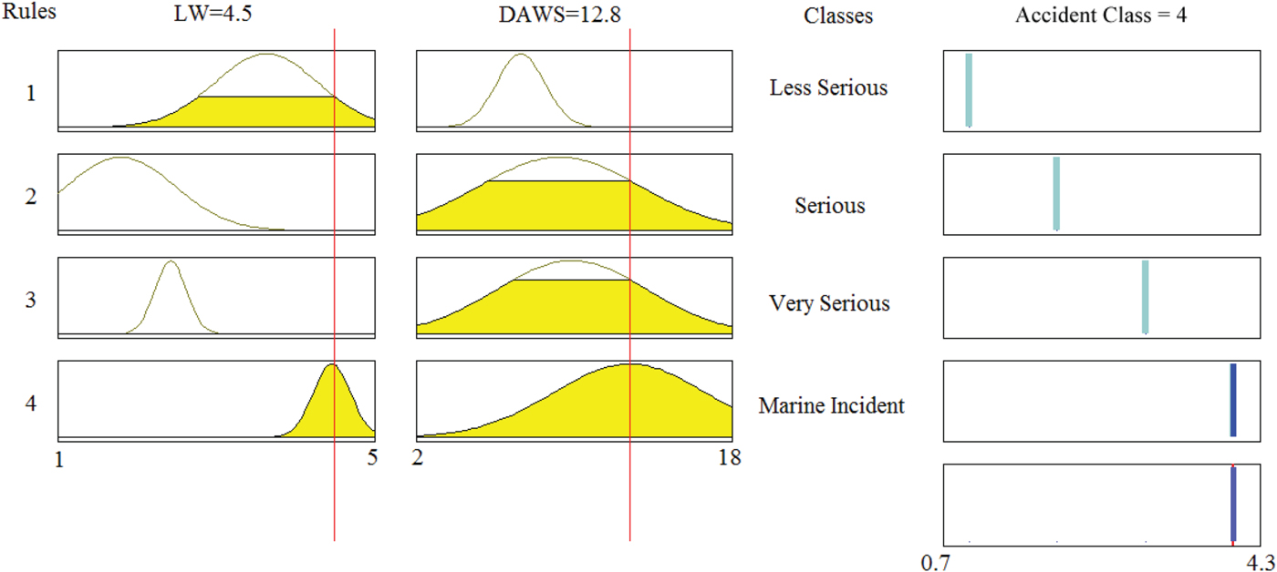
Although only two features were used, the obtained results are similar to the previous results for ANFC-LH. The result shows that GRT and LOA are less important than the others for this method. Figure 10 shows the fuzzy rules of ANFC-LH for the selected features.
The fuzzy rules of ANFC with two selected features.

The obtained results via ANFC-LH can be abstracted with below equal weighted if-then rules.
-
• If GRT<6 tonnes and LW>2 m and 2<DAWS<3 m/s then accident type is Less Serious
-
• If LW<2 m and 2<DAWS<18 m/s then accident type is Serious
-
• If 2<LW<3 m and 2<DAWS<3 m/s then accident type is Very Serious
-
• If LW>4 m and DAWS>4 m/s accident type is Marine Incident
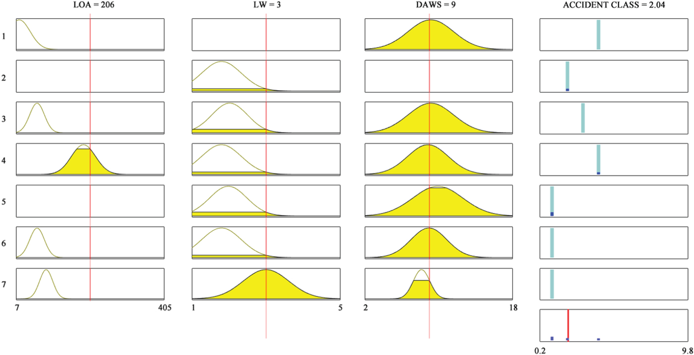
On the other hand, the fuzzy rules of GOFC are shown in Figure 11.
The fuzzy rules of GOFC with three selected features.

When the genetic algorithm is performed, the genes of the membership functions of the GRT parameter are optimised as 0 (zero). So, it is automatically disabled. In addition, equal weighted if-then rules which are generated by GOFC are shown below.
-
• If LOA is short and DAWS is fast then Accident Type is Very_serious_accidents
-
• If LW is low then Accident Type is Less_serious_accidents
-
• If LOA is middle and LW is middle and DAWS is fast then Accident Type is Serious_accidents
-
• If LOA is very_long and LW is low and DAWS is fast then Accident Type is Very_serious_accidents
-
• If LW is middle and DAWS is very_fast then Accident Type is Marine_incidents
-
• If LOA is middle and LW is low and DAWS is fast then Accident Type is Marine_incidents
-
• If LOA is long and LW is high and DAWS is slow then Accident Type is Marine_incidents
As shown in the if-then rules above, although the LOA is important in determining the ship accident type on narrow waterways, they are not of more value than weather conditions for Istanbul Strait accidents. As seen in the figures above, most of the membership functions are overlapped by others for LOA, and there are no distinctive boundaries between the accident classes. Analysis also indicates that even appropriate parameters such as LW and DAWS can be major factors in serious maritime accidents as shown in the second set of if-then rules.
This situation can be explained by lack of pilotage. Pilots are of utmost importance for safe passage (Ucan and Nas, Reference Ucan and Nas2016). Lack of a sufficient and experienced pilotage service significantly increases the accident risks in the Strait (Poyraz, Reference Poyraz and Ö1998; Akten, Reference Akten2004; Yurtören, Reference Yurtören2004; Ece, Reference Ece2005; Ulusçu et al., Reference Ulusçu, Özbaş, Altıok and Or2009; Küçükosmanoğlu, Reference Küçükosmanoğlu2012; Erol and Başar, Reference Erol and Başar2015; Uğurlu et al., Reference Uğurlu, Erol and Başar2015). It is clearly seen from research that the human factor is the most important cause of marine accidents (Reason, Reference Reason1997; Portela, Reference Portela2005; Çelik and Çebi, Reference Çelik and Çebi2009; McKnight et al., Reference McKnight, Becker, Pettit and McKnight2007; Erol and Başar, Reference Erol and Başar2015; Uğurlu et al., Reference Uğurlu, Erol and Başar2015). So, Ulusçu et al. (Reference Ulusçu, Özbaş, Altıok and Or2009) suggested that mandatory pilotage should be implemented for vessels that pass through the Strait and it would be recommended for vessels longer than 150 m or 100 m. They stated that average accident risk would reduce by 7% and by 46% respectively. On the other hand, in this study we have shown that GRT and LOA do not have any distinctive boundaries between the accident classes determined by the IMO. Even though GRT and LOA are not distinctive for these accident classes, increasing ship sizes raise the accidents’ impacts on humans, environment and economy (Kristiansen, Reference Kristiansen2005; Uğurlu et al., Reference Uğurlu, Erol and Başar2015). Consequently, in narrow passages such as the Istanbul Strait in which adverse weather conditions can prevail, pilotage services should be mandatory or strongly recommended for all transit vessels regardless of size restrictions. In this context Küçükosmanoğlu (Reference Küçükosmanoğlu2012) emphasises the necessity of a pilot service through the Istanbul Strait regardless of the size of the vessels. However, according to the Montreux Convention there is no mandatory pilotage for transiting vessels. Thus, aids to navigation in the Strait should be improved consistently and all ships have to follow the passage guidelines.
In their study on the Singapore Strait, Qu et al. (Reference Qu, Meng and Suyi2011) have revealed that speed is a crucial factor in increasing marine accidents. When viewed from this aspect, according to MTRTS (1998), within the Istanbul Strait vessels may not proceed at a speed more than 10 knots over the ground. However, if more speed is needed to maintain good steerage, the nearest traffic control station shall be notified and the master shall proceed with care and caution at a speed which will not create any danger of collision or cause damage by wave making to the banks or properties and other vessels in motion or tied up (MTRTS, 1998. Article 13). However, according to our results, adverse weather conditions have a significant impact on the occurrence of accidents. Therefore, speed and size limitations must be determined in compliance with meteorological conditions for narrow sea passages in which the geographical and meteorological conditions prevail. Thus, the possibility of an unwanted event will be lowered for adverse weather conditions.
6. CONCLUSION AND RECOMMENDATIONS
In this study, maritime accidents occurring in the Istanbul Strait have been analysed using AI methods such as ANFC, ANFC-LH, ANN and GOFC. Experimental studies show that the ANFC, ANFC-LH and GOFC methods demonstrate similar recognition success. However, ANFC-LH and GOFC rules give us the behaviour of features for different accident types. These rules can be used to develop regulations to assist in reducing their number and severity. The analyses show that there is more than one satisfactory method to reduce accidents.
We have also proposed equal weighted if-then rules. The Ministry of Transport, Maritime and Communications Search and Rescue Department and the Turkish State Meteorological Service databases are used in this study after a data-cleansing procedure. It can be concluded that as LOA increases, the severity of marine accidents rises. Also, as weather conditions deteriorate, the severity of marine accidents can increase. Thus, weather conditions and the ship size should be controlling parameters for the Turkish authorities.
In order to decrease the number and consequences of maritime accidents in the Istanbul Strait, the following precautions that have been developed according to the abovementioned rules may be helpful: (1) Maritime traffic in the Istanbul Strait should be rearranged according to weather conditions. (2) New anchoring areas for vessels could be defined to avoid the effects of bad weather conditions for ships waiting to pass through the Istanbul Strait. (3) Piloting and escorting services should be encouraged for ship masters with limited experience in narrow waters. Indeed, the IMO should be lobbied to make compulsory legal arrangements for taking pilots on narrow and dangerous waterways with intensive ship traffic such as the Istanbul Strait. (4) Safety rules related to weather conditions should be continuously improved. (5) According to if-then rules presented in Section 4, necessary risk reduction solutions such as a ship size limit should be implemented to assure the safe navigation under bad weather conditions in the Istanbul Strait. Due to its strategic importance and traffic density, maritime transit traffic safety in the Istanbul Strait should be increasingly enhanced.
Results obtained from this study can be an important input for risk assessment. The novelty in in this study is to emphasise the importance of weather conditions in the precautions taken to mitigate navigational and environmental risks.
ACKNOWLEDGEMENT
We thank the Ministry of Transport, Maritime Affairs and Communications and Turkish State Meteorological Service for providing us with the data used in this paper.