

On July 1, 1978, Stavropol΄'s First Party Secretary, Mikhail Gorbachev, enthusiastically wrote to General Secretary Leonid Brezhnev. He thanked him for all the good irrigation had brought to his region since the Central Committee's plenary session in May of 1966, when “melioration” (melioratsiia) became the staple ideology of Soviet agriculture.Footnote 1 In the words of Gorbachev, this formed the basis for crop cultivation and benefited animal husbandry greatly. The advent of the river Kuban's waters in the dry steppe of the North Caucasus was to radically change the lives of the workers for the better.Footnote 2 Unfortunately, modern irrigation technology as a panacea to increase agricultural productivity brought with it problems of water shortage and soil erosion as they were witnessed in all the “hydraulic societies” around the world.Footnote 3
As this paper shows, Gorbachev's remarks were symptomatic for the underlying imaginaries of steppe reclamation in southern Russia that are deeply rooted in tsarist times. It argues that the idiosyncrasies of the Soviet system hindered a deeper understanding of the local steppe biome and the implementation of locally well-adapted farming methods. This contributed to the rise of an agromeliorative complex that, from 1965, was spearheaded by the highly influential Ministry of Melioration and Water Management (Minvodkhoz). The steppe became a showcase for ideals of progress where large-scale technical solutions ruled supreme and trumped attention to detail. In this regard, the region under scrutiny serves as a prism through which the evolution of a high-modernist ideology, mirrored in both state policies and local agency, can be closely observed.
Under the Plough—the Steppe as an Agricultural Imaginary
With the expansion of Muscovy to the south and east of Eurasia, the steppe was encountered as a hostile and undeveloped territory that served as a buffer between Russia and its “barbaric” enemies. Successively, it was colonized by Cossack and other forces, and secured through a system of fortified villages (stanitsy).Footnote 4 Russia's victory in the first Russo-Turkish War (1768–1774) brought the territories on the right bank of the Kuban under its control.Footnote 5 In the course of the nineteenth century, the empire's southern borders were expanded through targeted settlement, the ethnic cleansing of local peoples like the Circassians (Adyghe), and the “exodus” of the Nogais and others to the Ottoman empire during the Caucasian War (1817–1864) and after.Footnote 6 Military encampments like Stavropol΄ (founded in 1777) and Yekaterinodar (1793, renamed Krasnodar in 1920) soon became cities that attracted civilian settlers who were generously offered land and credit by the state while being exempt from taxes and military service.Footnote 7
Over time, the frontier became a borderland, and the Greater Caucasus Mountains (Bol΄shoi Kavkaz), ranging from the Taman Peninsula by the Sea of Azov to the Absheron Peninsula by the Caspian Sea, marked not only a natural, but also a cultural boundary between Orient and Occident.Footnote 8 From the 1670s until 1896 about ten million people moved south, of which a third arrived in the last quarter of the nineteenth century alone. By 1897, about 2.5 million farmers settled along the Kuban River and in today's southern Ukraine. With the indigenous population either displaced or assimilated, the steppe had lost its function as a space of cultural exchange, of negotiation and mediation between Russia and its neighbors.Footnote 9 As a result, steppe imaginaries evolved towards the fin de siècle: the conquest of the semi-arid wilderness became a project of national consolidation. This was mirrored in political and scientific discourse, especially on the causes of climate change in the steppe where precipitation seemed to decrease.Footnote 10
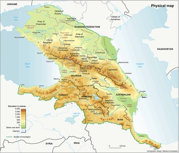
As a response to the harvest failure and the ensuing famine of 1891/92, scientists and state representatives pondered the necessity of complex means of soil amelioration.Footnote 11 The doyen of Russian climatology, Aleksandr Voeikov (1842–1916), was among the first to consider irrigation in the Kuban region.Footnote 12 His claim that “even the Sahara's soil is fertile when there is water” laid the example for later endeavors.Footnote 13 Several military expeditions had already conducted research on the specific conditions for agriculture in the North Caucasus at the time. While their reports were inclined to promoting extensive measures for land reclamation as a prerequisite for higher yields, finance minister Sergei Witte (in office 1892–1903) preferred to see state investment concentrated on industry. In his eyes, these expeditions “served only to confirm that large-scale irrigation was not a viable solution in the steppe region.”Footnote 14 Without determined support by the state and hindered by revolution and war, hydro-amelioration made few advances until the late 1920s, when collectivization reordered the sphere of agriculture in the North Caucasus (Figure 1).
Map of the Caucasus showing the rivers Kuban, Yegorlyk, Kalaus, Kuma and Terek (from west to east). Image creator credit: Manana Kurtubadze, available at https://www.grida.no/resources/5333.

Before the October revolution, grain cultivation spanned from the Kuban river in the west to the Kuma River in the east, and from the Manych River in the northwest to the town of Mozdok, fifty miles north of Vladikavkaz on the left bank of the Terek. Grain export was a major economic factor for the Russian empire, and the local black earth (chernozem) as well as the brighter chestnut soils (kastanozem) in the drier areas to the northeast ranked among the world's most fertile grounds for agriculture.Footnote 15 Especially the chernozem was hailed as “a symbol of the glory and strength of the Russian state,” “the most important national treasure,” and “Russia's main provider.”Footnote 16 Except for several minor irrigation canals along the Terek and Malka rivers, the drier steppe areas remained without artificial sources of water as the aquifers were too deep to be reached by wells. Just as Voeikov had suggested, these areas were used for sheep and cattle. However, overgrazing in the steppe soon exacerbated the damage of dry, hot winds from the east (the sukhovei).Footnote 17 Known “methods aimed to work with the steppe environment, rather than combat or struggle against it,” enforcing fallow and crop rotation, were often neglected.Footnote 18
It was not until the advent of Soviet power that major irrigation projects were undertaken, as large-scale engineering solutions were considered not only a prerequisite for civil settlement, but a form of modernity that promised social progress and material wealth.Footnote 19 The steppe, which was a “zone of innovation” during the nineteenth century that inspired the evolution of genetic soil science as a holistic approach to agriculture, became a showcase for technological advancement and man's dominion over nature as a new driving geological force.Footnote 20 In the mid-1980s, this introduction of “Asian and Egyptian irrigation principles and techniques” was openly criticized by Soviet pedologists like Viktor Kovda (1904–1991), who for decades had seriously doubted the suitability and sustainability of such measures on European soils.Footnote 21
Social Upheaval through Wars and Collectivization
Following WWI and the revolutions of 1917, the North Caucasus was especially affected by the ensuing civil war and famine of 1921.Footnote 22 In November of 1926, Stavropol΄'s Party organs decided to propagate collectivization through the formation of collective farms (kolkhozes), “tractorization,” and the struggle with supposed “kulaks” (kulatskie elementy) in the villages.Footnote 23 By September of 1929, however, the number of agricultural collectives had risen to a mere ninety-two, officially on a voluntary basis.Footnote 24 Collectivization turned brutal in the North Caucasus when the local population protested Stalin's policy of grain requisitioning (khlebozagotovka), which was again followed by famine.Footnote 25 By 1933, the situation had worsened drastically: in January and February more than 40,000 people died of hunger. The death toll reached its peak in April and May with 120,000 victims. During the year 1933, more than 424,000 people perished; another 100,000 were incarcerated, and 26,000 of them deported to Kazakhstan and the far north.Footnote 26
As a result of forced collectivization and so-called “dekulakization,” more than one million farmers and farm workers fled either to cities or to construction sites all over the USSR. This meant not only the loss of valuable agricultural knowledge, but also of productive forces in the countryside.Footnote 27 The rural exodus prepared the ground for large-scale solutions that were to be implemented without special local expertise. At the end of 1937, 2,433 kolkhozes existed along the Kuban River with more than 360,000 workers. The degree of mechanization remained low, however, and the use of horses was still common.Footnote 28 Most of the work on the fields was done through manual labor. The fledging chemical industry, tasked with the development of fertilizers, focused on the production of weapons and ammunition instead.Footnote 29 Not until the 1970s did “chemicalization” (khimizatsiia) take a hold around Stavropol΄.Footnote 30 In its wake, misuse of pesticides was common as farm workers seldom knew the correct dosage.Footnote 31 This eventually led to an increased child mortality, notably higher cancer rates among women, and the mass extinction of fish in the Kuban River.Footnote 32
In the eyes of political leaders, both the forced industrialization of the first five-year plan (1928–1932) and the evolution of large-scale agriculture through collectivization required the expansion of a hydrotechnical infrastructure. Thus, the Russian periphery was to be integrated into the Soviet system under the guise of modernization.Footnote 33As the 1920-GOĖLRO-plan on the electrification of Soviet Russia remained unfulfilled by 1937, several small and medium-sized hydropower-stations along the Kuban River were projected to satisfy the ever-increasing energy demand.Footnote 34 Canals were designed to divert water to the fields. The hydrotechnical complex Laba-Urup-Kuban to the south, between the two cities of Krasnodar and Stavropol΄, became “the most important endeavor in creating a hydro-technical basis for the evolution of arable and horticultural cropscattle breedingregional water supply, and the fight against floods.”Footnote 35 However, pedologists and other experts tasked with evaluating this project by the State Planning Committee (Gosplan) identified several problems early on: they especially doubted the overall profitability of the complex, as energy production was only feasible on the largest tributaries of the Kuban River. Also, its water quality was fluctuating and seldom corresponded to the official standards for potability. Its high mineralization rate largely prohibited its use for irrigation.Footnote 36 The lack of a concerted approach delayed the development of hydropower along the Kuban well into the 1950s.Footnote 37 With the discovery of seemingly cheap fossil fuels in Siberia, the “hydroenergetic decade” (Klaus Gestwa) came to an end before the majority of these ideas were realized in the North Caucasus.Footnote 38 What remained of the hydrotechnical complex was the practice of irrigation, which originally was more of an offshoot of hydropower than a truly independent branch.
Because of the diverse geographical and climatic makeup that ranged from humid, mountainous areas in the south to the semi-arid steppe in the northeast, Stavropol΄ became—in the words of the last president of the Lenin All-Union Academy of Agricultural Sciences (VASKhNIL), Aleksandr Nikonov, (1984–1992)—a “laboratory”; a testing ground for Soviet agriculture.Footnote 39 The region's abundant resources—water from the mighty rivers that spring from the Caucasus mountains, and the fertile chernozem and kastanozem of the plains—were to be exploited in an exemplary way through the construction of an extensive network of canals, pumping stations, and sprinkler systems. One of the major projects to reclaim Stavropol΄'s steppe was greenlighted by the Council of People's Commissars in April of 1935. Until year's end, the construction trust Terstroi in Pyatigorsk, about eighty-five miles southeast of Stavropol΄, was tasked with developing a scheme that would ensure water-supply on 3.5 million hectares of land and create an irrigation infrastructure on a tenth of this area between the rivers Kuban, Kalaus and Yegorlyk.Footnote 40 The first important step was excavating the Nevinnomyssk Canal to divert water from the Kuban to the Yegorlyk across a distance of about thirty miles. Although construction started in 1936, the first section was finished only in 1948—at the same time as the Svistukhinskaia hydroelectric power plant, which was one of the few connected to the grid.Footnote 41 Apart from the often-uncoordinated planning and an overall lack of machinery and building material, the turmoil and destruction of the Great Patriotic War and German occupation were eventually blamed for the delay.Footnote 42
Following the example of the Great Fergana Canal in Central Asia, which had been finished in 1939 in just forty days through forced labor, the Nevinnomyssk Canal was also designated a “people's construction site” (narodnaia stroika), to be built by the local population under harsh conditions.Footnote 43 This proved extremely problematic for kolkhoz workers as it did not allow them to tend to their fields and animals while they were on site. Further food shortages and hunger were the result. Additionally, the kolkhozes had to carry a great part of the financial load: in the case of the Nevinnomyssk Canal, it was half of the overall capital investment.Footnote 44 In 1940 alone, more than 50,000 kolkhozniki were forced to help in construction, among them 15,000 adolescents, mobilized by the Komsomol (Communist Youth League) as “shock workers.”Footnote 45 In the glorious language of Party propaganda, “poverty, famine and the ruin of local farmers” were to be issues of the past, as the new “efficient technology” of these canals would conquer nature. “Water is the source of life. Water can transform Stavropol΄ into a blooming region; it allows raising grain, cotton, fruits, and vegetables to abundance!,” a local newspaper promised.Footnote 46 At least 45,531 Gulag prisoners lived in no less than ten different settlements all over Stavropol΄ during these times. They were forced to work in road construction and the timber industry, but also in agriculture and hydrotechnical projects.Footnote 47 After the reorganization of the GULag-system in the mid-1950s, the Ministry of Internal Affairs continued to produce irrigation equipment in its corrective colonies until the fall of the Soviet Union.Footnote 48 Thus, the project to reclaim the steppe was not only a mission to cultivate its semi-arid “wilderness” but also to subjugate and “civilize” the undesired elements of Soviet society.
In order to evaluate the designs for water-supply and irrigation of Stavropol΄'s steppe through the Nevinnomyssk Canal, Gosplan had put together an expert commission of soil scientists, geologists, and engineers that convened in Moscow from September 1 to November 26, 1938. Even though they generally supported the project in their final report, they explicitly warned of its very high water consumption: while irrigated fields encompassed less than three percent of the whole area supplied with water, they used almost a third of the local resources. Especially in the semi-arid regions to the north, this was considered unnecessarily wasteful. To lower the risks of water logging and soil salinization, the commission furthermore underlined the need for drainage on at least 36 percent of the fields.Footnote 49 Their warnings, however, were not heeded.
The discussion whether to build drainage systems or not was of a highly ideological nature. It culminated in the late 1940s when the agronomist and charlatan Trofim Lysenko (1898–1976) became the president of the Lenin All-Union Academy of Agricultural Sciences (VASKhNIL). Soil scientist Viktor Kovda, who propagated the installation of drainage systems as part of a comprehensive method of soil reclamation, was harshly attacked as a proponent of “reactionist theories in pedology” that “played into the hands of the enemies of Communism” by the hydrologist Vagram Shaumian (1908–1964), a proponent of Lysenkoism, and representatives of Gosplan in a series of talks and articles.Footnote 50 Thus, as a result of Soviet science politics under Stalin and Khrushchev, who kept Lysenko as a personal advisor after the dictator's death in 1953, the criticism of melioration as wasteful remained unmitigated until the late 1980s when Gorbachev reorganized the agricultural sector.Footnote 51 The preference for large-scale solutions, often implemented with insufficient observance of local conditions, was the most striking systemic flaw of the USSR's centrally administered economic planning body. It was also one of the main reasons for its failure to establish a sustainable and self-reliant system of land reclamation.
From Post-War Reconstruction to Large-Scale Infrastructures
On the eve of the German attack on the Soviet Union in June 1941, the basic outlines for the hydro-ameliorative infrastructure were drawn: since the late 1920s, Krasnodar had developed a strong focus on rice cultivation while Stavropol΄'s canals kept expanding into the dry steppe.Footnote 52 After the war, however, agriculture was in a deep crisis: not only was the highly fertile black earth in Ukraine and southern Russia riddled by the brutal fighting and scorched earth-tactics of both the Wehrmacht and the Red Army, it also lacked laborers.Footnote 53 Furthermore, the consequences of collectivization and dekulakization were strongly felt in the Soviet village: most kolkhoz workers continued to live in poverty, and they were in dire need of specialized tools and a formal agricultural education. The continuing rural exodus could not be contained.Footnote 54 The famine of 1946–47, which resulted from a long period of drought, claimed more than one million lives.Footnote 55 This catastrophe was later described by the Minister of Melioration and Water Management (Minvodkhoz) Evgenii Alekseevskii (1906–1979) as the formative moment for the notion that agriculture was generally impossible without irrigation.Footnote 56
Although local Party leaders claimed to be fulfilling the quota of the post-war plan, vast swaths of land lay fallow and hundreds of canals remained destroyed. Reconstruction proved difficult. As a result, agricultural productivity stagnated between two thirds and three fourths of the 1940-level by the end of the decade, even according to optimistic official statistics.Footnote 57 It was not until 1954 that the prewar-level was exceeded.Footnote 58 Instead of carefully adjusting agricultural policies to the specific needs of collective farms, the Soviet leadership decided to “take the bull by the horns” through the implementation of large hydrotechnical infrastructures.Footnote 59 Consequently, the fourth five-year plan (1946–1950) was gradually overshadowed by Stalin's “Great Plan for the Transformation of Nature.”Footnote 60 It promised a solution to the USSR's most pressing resource problems within the following fifteen years. The “Stalin-Plan” propagated reforestation and the creation of shelter belts against wind erosion as well as crop-rotation and the development of irrigation to conquer drought (zasukha) in the semi-arid steppe.Footnote 61 It was complemented by the “Great Construction Works of Communism” (Velikie stroiki Kommunizma), which focused on hydro-engineering and melioration.Footnote 62 While the former was restorative in character, the latter followed a transformational vision.
Adding to these ideas was the “Davydov-Plan,” published in 1949, that called for the diversion of Siberian rivers into the arid steppe of Central Asia. In 1954, the Leningrad bureau Gidroproekt, which was responsible for the construction of hydroelectric dams under Stalin, put forth the diversion of northern Russian rivers into the Volga under the auspices of the Ministry of Energy. Together, these projects promised a transition into a bright future of food security and industrial ascent. The reasoning was simple: ninety percent of the arable land in Central Russia, the North Caucasus, Ukraine, and Central Asia—where three quarters of the Soviet population lived—used merely 24 percent of the country's freshwater resources while two thirds of the cultivated area was situated in the arid and semiarid zone.Footnote 63
Soviet pedology, although “down to earth” in every sense of the phrase, did not remain unmarred by Stalinist policies: regardless of the fact that Viktor Kovda was a renowned scientist with a notable career ahead of him at UNESCO and the International Society of Soil Science (ISSS), he nonetheless joined the propagandist folklore that surrounded the “Great Plan for the Transformation of Nature” with a popular book published in 1952 that was often read as a call to arms in support of the project.Footnote 64 This, however, has to been seen in light of the controversy over Lysenkoism when Kovda had fallen from grace and tried to prove his loyalty to the system in order to save his career.Footnote 65
Promises and Perils of Progress
The same year that Kovda published his monograph on the Stalin-Plan, the Krasnodar branch of the planning institute Giprovodkhoz presented its first comprehensive scheme for the use of the Kuban River's resources.Footnote 66 It revealed a hitherto locally unmatched scope with hydro-infrastructure ranging from Rostov-on-Don to the northern flanks of the Caucasus Mountains, and from the Sea of Azov in the west to the river Terek in the east. In all, 759 kolkhozes and 131 state farms (sovkhozy) on an area of 11,650,000 hectares—larger than Portugal—were set to be supplied with water. Irrigation was to be introduced on more than one million hectares.Footnote 67 Only the planned diversion of the northern rivers (perebroska severnykh rek) in the 1970s expanded upon this scheme with the idea to force water from the north Russian river Pechora through the Volga-Chograi-Canal into the Kuban.Footnote 68 Although its construction was halted after protests in the early 1990s, the unfinished canal had devastating environmental consequences for the fauna of Kalmykia to the northeast of Stavropol΄, as it hindered the migration of about 160,000 Saiga antelopes and the grazing of even more domesticated animals like sheep. The unlined canal bed soon filled with highly mineralized groundwater and the once fertile pastures surrounding it turned into sandy deserts.Footnote 69 In the mid-1990s, the situation in Kalmykia became catastrophic: half of the agricultural area was degraded, especially through anthropogenic soil salinization caused by the failed hydro-ameliorative projects.Footnote 70 Here, the promises of irrigation turned into an ecological nightmare for the steppe biome.
The 1952-scheme was not realized for several years. This was mainly due to the often unclear responsibilities within the Soviet planning system. The bureaucratic see-saw is shown not only in the delayed and sometimes chaotic communication between center and periphery, but also by a lack of clear direction in the development of irrigation infrastructures.Footnote 71 This only furthered local initiative, despite warnings from soil scientists who recalled the poor experience in Central Asia and the South Caucasus.Footnote 72 Regional Party leaders gladly seized the opportunity to obtain state investment that could be partly diverted into their own pockets and into those of their cronies.Footnote 73 Soviet policies of land reclamation developed concomitantly in center and periphery: while Moscow propagated its grand yet abstract transformative visions with the goal to extend its power into the outer reaches of the USSR, local Party leaders often followed their own agenda set on personal political empowerment.
In Stavropol΄ it was decided to further develop the steppe to the north and northeast through hydro-ameliorative measures. In addition to the Kuban, the eastern rivers Kama and Terek were marked for large canal projects. Thus, the prestigious Kuban-Kalaus system, begun in 1957 and renamed the Great Stavropol΄ Canal in 1968, was to supply three million hectares of land with water—half the area of Stavropol΄ region—and to irrigate about 550,000 hectares. Here, too, delays were caused by the ubiquitous lack of machinery, expertise, and construction material.Footnote 74 Just as the Nevinnomyssk canal, this project followed the Central Asian example and was based on the principle of so-called “complex reclamation” (kompleksnoe osvoenie) which not only focused on the construction of hydro-ameliorative technology, but also aimed at creating a provisional social infrastructure consisting of schools, cultural centers, and facilities for sports and recreation to promote trust and faith in the system.Footnote 75 The reality was bleak, however, as the workers had to live in makeshift housing without general educational facilities for their children and leisure activities for themselves.Footnote 76 This truly was a far cry from the full-mouthed promises of blossoming oases of progress in the steppe.
By the mid-1960s, irrigation had become a core concept of Soviet agriculture. Following the creation of the Ministry of Melioration and Water Management (Minvodkhoz) in 1965, the Soviet leadership finally broke with Lysenkoist ideology. Hydro-engineers formerly involved in the Stalin-Plan were offered new prospects: with the Party decree from June 1966 “On the broad evolution of soil melioration for the yield of high and steady harvests of grain-crops and other agricultural produce,” they focused on hydro-amelioration as the new grand promise of Soviet agriculture instead of planting shelter belts and further experimenting with the hitherto propagated “grassland rotation system” (travopol΄e).Footnote 77 The decree envisioned tripling, and in some cases even quadrupling, crop production. Thanks to close interpersonal connections—since the late 1940s future Minvodkhoz-minister Alekseevskii had been working with Khrushchev, in the 1960s he gained Brezhnev's support—and the systemic economic problems of the USSR, especially its high inflexibility that caused shortages in specialized production, irrigation was seen as the main remedy of an ailing agricultural sector.Footnote 78
Shortly after its creation, Minvodkhoz was already reprimanded by the financial authorities for its grandiose spending on hydro-infrastructural projects with little visible return.Footnote 79 The non-transparent inner workings of this agromeliorative complex are highly representative of the key issues of the Soviet administrative command economy: a lack of external control and internal accountability, overall low productivity, and a waste of natural resources. Much like the Soviet military-industrial complex, it developed into a monolithic structure that became the object of harsh public criticism in the 1980s. Their similarity was not least expressed in the triad oborona (defense), kosmos (the space program), and melioratsiia (hydro-amelioration) as the branches that potentially dealt the most damage to the state budget and the environment.Footnote 80
Nonetheless, the meliorators were given carte blanche well into the 1980s as Gorbachev feared the Soviet Union could fall further behind its western competitors in gross agrarian output. In a Politburo meeting on February 17, 1986 the General Secretary was cited saying: “The whole world thrives on irrigation. And us—are we supposed to renounce it? All of the ‘Green Revolution’ is based on irrigation.”Footnote 81 Yet the ideals of this “Green Revolution,” which encompassed not only irrigation but also specialized fertilizers, seeds, pesticides and land cultivation technology that would in conjunction significantly boost agricultural productivity, were never fully implemented in the USSR.Footnote 82 This is obvious in the limited scope of “melioration” itself. Compared to countries with similar climates, like Canada, Soviet yields were low and unsteady.Footnote 83 Consequently, since 1963, the USSR imported grain to avoid undernutrition or even famine among its citizens.Footnote 84 This was a bitter lesson learned from the hunger years of 1932/33 and 1946/47. The reclamation of the steppe was thought to end these shortages.
Conflicting Infrastructures
Krasnodar and Stavropol΄ evolved as two centers of agriculture that increasingly competed for resources. While the former focused on crops such as grain, sugar beet, sunflower, and rice, the latter relied on livestock farming to a high decree. With Stavropol΄'s vodniki (hydro-engineers) reclaiming the steppe, the neighboring region of Krasnodar drastically expanded its capacities for rice-sowing. For this, the Krasnodar reservoir was put into operation in 1975 as the largest artificial body of water in the North Caucasus with a capacity of more than three billion cubic meters—about one tenth of Lake Mead formed by the Hoover Dam.Footnote 85 In February of 1966, both the Krasnodar Party and the Executive Committee had argued for its construction, since the Kuban-Kalaus irrigation system in Stavropol΄ was expected to drain so much water from the river that rice cultivation at its lower reaches would become impossible without it. The reservoir was built within the boundaries of the Adyghe Autonomous Oblast to the south of Krasnodar city. It flooded fertile pastureland and holy sites, about 16,000 people were resettled.Footnote 86 Several waves of protests by the ethnic Adyghe minority notwithstanding, the reservoir is still in use today.Footnote 87 It serves as a monument to the recklessness of Soviet and Russian nature politics.
In his memoirs, former Stavropol΄First Party Secretary Mikhail Gorbachev (1970–1978) later blamed Sergei Medunov, Krasnodar's Executive Committee Chairman (1969–1973) and First Party Secretary (1973–1982), for the fervent infighting for capital investment and natural resources.Footnote 88 While Medunov, a close ally and crony of Brezhnev's, continued the legacy of his predecessors as he heavily propagated rice cultivation with the promise to reach harvests of up to one million tons at the lower Kuban in 1980, Gorbachev proved to be an avid supporter of irrigation as well.Footnote 89 He pushed such ambitious projects as the Great Stavropol΄ Canal, which by the late 1990s tapped the resources of the Kuban, Terek, and Kuma Rivers at a length of more than 200 miles with the goal to supply 2.6 million hectares of land with water. The undiminished faith in high technology increasingly overshadowed the requirements of the steppe biome.
The envisioned reclamation of the steppe took longer than anticipated, however. By 1968, after more than ten years of construction, the first section of the Great Stavropol΄ Canal was still not finished. While ever more water was flowing into the dry steppe, not even half of the fields marked for irrigation were reclaimed. The canal's costs were first estimated at a staggering 404 million rubles and soon climbed to 644 million.Footnote 90 Nonetheless, the undertaking enjoyed strong support by the Politburo as it was expected to do the region a lot of good, defeating drought and the ravaging dust storms (pyl΄nye buri) once and for all (which it did not).Footnote 91 On the drawing boards, the steppe was reimagined as a future granary for Russia. Yet in the first months of 1969, the project experienced its first major setback: about one million hectares of arable land—more than half of the total sown area—were severely damaged by dust storms, strong winds (uragany), and frost in the region of Krasnodar. The agrarian infrastructure—especially canals, shelter belts, and pasture—was badly affected. In Stavropol΄ region alone, repair costs were estimated at seven million rubles.Footnote 92
These were not the only problems: specialists of Gosplan and VASKhNIL warned of the high content of soluble salts along the Great Stavropol΄ Canal that was potentially devastating for agriculture. Also, the canal's concrete tunnels were unprotected against the highly mineralized, corrosive groundwater. Countermeasures, like epoxy coating, were not feasible as they either proved to be too expensive or the necessary materials were unobtainable. Regardless of these difficulties, Stavropol΄'s Party and Executive Committee enforced hydro-construction: between 1971 and 1975 another 125,000 hectares were to be reclaimed at a cost of 525 million rubles.Footnote 93 Thousands of Komsomol members were again mobilized to work on the construction sites.Footnote 94 Yet, even these grandiose canals did not end the local water shortage. When the region suffered another severe drought in June 1976, with winter wheat yields falling to one third of the previous fifteen years’ average, 60,000 tons of animal fodder had to be sent to Stavropol΄ from Central Russia and other parts of the Soviet Union.Footnote 95 Time and again, the Soviet state lost the battle with the forces of nature in the dry steppe to the east of the Kuban.
The introduction of large overhead sprinkler systems in the early 1970s further strained the Kuban's resources. Until the end of the ninth five-year-plan in 1975, 6,000 “Fregat” and 7,500 “Volzhanka” machines were to be installed all over the Soviet Union while the irrigated area grew more than twofold, reaching 3.2 million hectares. The model “Fregat” was widely used on the fields of Stavropol΄.Footnote 96 It moved virtually independently, propelled by water pressure alone. As the electrification of rural areas remained an issue until the end of the Soviet Union, these devices were connected to diesel-powered pumping stations which used large amounts of fuel and heavily contaminated the air with their exhaust fumes.Footnote 97 The model “Fregat” was based on the already outdated “Valley” by the US cooperation Valmont Irrigation. With Soviet industry lagging behind in the often-propagated automation of agriculture, trade representatives had acquired all the necessary blueprints and licenses for this machine in the late 1960s; Soviet specialists were trained by Valmont in the US in its assembly and maintenance.Footnote 98 This was typical for the time, as the Soviet Union relied heavily on the import of western technology: Philip Hanson counted 1,300 licenses acquired from the mid-1960s to 1976 alone.Footnote 99 Thus, the USSR incorporated capitalist practices and promises of progress into its vision of a scientific-technical revolution.Footnote 100
In 1973, the USSR officially caught up with the US in their relative use of overhead irrigation on more than 21 percent of the sown area.Footnote 101 In the total yearly growth of irrigated territory they had even surpassed their western rival with 960,000 to 600,000 hectares.Footnote 102 Overhead irrigation was the last evolutionary step of melioration in the Soviet Union, as more advanced and locally adapted methods like drip irrigation never made it to the fields. This was not for want of knowledge (experimental stations were already set up in the early 1970s) but for the inflexibility of Soviet production, especially in supplying plastic pipes, and for a lack of specialists who could adjust such rather precise devices to local needs.Footnote 103 As a result, high water consumption was an urgent problem that remained unsolved throughout the Soviet era. Adding to this was the notion that water was an inexhaustible natural resource that anyone could freely dispose of. Only between 1949 and 1956 did authorities experiment with a fee in some regions. This idea, however, was abandoned as the collective farms lacked the financial resources and refused to pay. Also, consumption could only be estimated; an exact control of the amount of water used was practically impossible.Footnote 104 The waste of natural resources was not even accounted for in the calculation of reclamation costs.Footnote 105 Planning and maintenance was also regularly disregarded to keep the overall budget artificially low on paper. Eventually, Soviet large-scale meliorative projects never paid for themselves, also due to the unexpectedly low yields.Footnote 106 This is the reason why the meliorative industry collapsed in the 1990s under a quasi-liberal competitive market.
The fixation on large technological systems that were to function regardless of local conditions is reflected not only in the planning of meliorative projects, but also in dealing with their negative consequences. In order to address the increasing wind and water erosion of agricultural land, for example, ever “more advanced” methods and machines were to be developed and implemented while only a small group of experts seemed to truly realize the vicious cycle of these actions.Footnote 107 In the 1970s, hydro-amelioration was the fastest growing sector of the Soviet economy.Footnote 108 Its idiosyncrasies dictated the further course of action: constant expansion trumped demand-responsive water use. With all the resources of the Kuban area to be tapped until 1986, it was deemed necessary to develop the Volga as a supplier for the irrigated areas of Krasnodar and Stavropol΄ until the year 2000. This project was directly linked to the diversion of the north Russian rivers. Even Gosplan criticized these plans: Minvodkhoz should rather adapt to scarcity and increase the “economic effectiveness” of irrigation, as it already exceeded natural capacities more than fivefold, while yields were two and a half times lower than anticipated.Footnote 109 The idea to convert the steppe into an agricultural powerhouse bore potentially devastating results, as the Kuban region faced a similarly dreadful fate as the desiccating Aral Sea basin.Footnote 110
In the following years, recommendations on “rational water use” and the “perfection of irrigation methods” were largely ignored. In 1979, Krasnodar presented plans for the expansion of its reservoir, while irrigation was significantly intensified along the Great Stavropol΄ Canal.Footnote 111 In 1982, a group of experts including Ivan Aidarov (born 1932), who would later criticize Soviet melioration for its “formal transfer of irrigation experience from Central Asiawith quite different natural conditions and requirements for irrigated agriculture,” noted that an increase in agricultural production was possible most of all through the expansion of the meliorative industry.Footnote 112 By the early 1980s, the meliorators strongly believed in the motto emblazoned in big letters on the main weir of the reservoir at Ust-Dzheguta where the Great Stavropol΄ Canal begins: “The water of the Kuban flows where the Bolsheviks command it to.”Footnote 113
Belated Attempts at Structural Reform
Obvious flaws of the meliorative infrastructure tainted the utopian image of control over nature. Criticism from within the administrative system grew louder, as the Minvodkhoz evolved into a monolithic structure that combined the planning, construction, and control of its own projects. This development did not come as a surprise: already in 1965, when the ministry was founded, skeptical voices within the Council of Ministers warned of the absence of outside supervision. The recurring complaint was: “The ministry itself approves the design work plan, designs itself, carries out project appraisals, approves projects itself and builds them itself. This is a complete lack of control, but so it became.”Footnote 114 The often-repeated short version of this was sami stroiat, sami prinimaiut (they build and commission themselves).Footnote 115 As a high-modernist agency, its projects replaced local knowledge by standardized procedures that made the steppe “legible” from the center, that is, intelligible and manageable in an abstract manner.Footnote 116 This oversimplified understanding of complex ecological processes proved highly deceptive.
Meanwhile, the expansion of melioration was accelerated by the long-term food program (prodovol΄stvennaia programma)—designed by Mikhail Gorbachev as secretary to the Central Committee on questions of agriculture and passed in 1982. It aimed to increase grain yields by 34 and meat production by 53 percent. In Stavropol΄, the resulting costs for the maintenance of infrastructure and irrigation were estimated at 1.208 billion rubles.Footnote 117 The ensuing criticism had many voices. Writer and editor of the literary journal Novyi mir Sergei Zalygin (1913–2000) was the most prominent example of a renegade meliorator. Channeling the frustration uttered in internal reports for decades about state policies of large-scale hydro-engineering, he coined the often-cited phrase “nature was against it, society was against it, but the administration was in favor.”Footnote 118 This rang especially true for the “projects of the century,” the planned redirection of the Siberian and northern Russian rivers to the south of the Soviet Union. The better-known eastern part Sibaral was to alleviate the dire state of the Central Asian cotton growing regions that drew ever more water from the dying Aral Sea.Footnote 119 The northern river diversion, in turn, was to provide the expanding agrarian sectors along the Volga and the Kuban with irrigation water.
On October 2, 1985 Literaturnaia gazeta published an open letter by Zalygin to Minvodkhoz-minister Nikolai Vasil΄ev (1979–1989), criticizing the irresponsible waste of natural resources. Zalygin called the misguided notion that water was free a central fallacy, as this had led to its scarcity in the first place, creating the vicious cycle of the river diversion scheme: ever larger irrigation systems that needed ever more water. It would be better, he reasoned, to finally enforce strict cost accounting and more responsible resource use instead.Footnote 120 Following the tone of this letter, many vodniki vented their frustration in complaints (zhaloby) to the Soviet Council of Ministers, bringing to the fore cases of falsified production numbers (pripiski), corruption, nepotism, personal enrichment, and overall questionable management practices within the Minvodkhoz-system.Footnote 121
In September of 1986, soil scientists also presented their damning verdict on the effectiveness of melioration in a letter to the Chairman of the Council of Ministers Nikolai Ryzhkov (1985–1991): while the need for comprehensive land reclamation was paid lip service in official decrees, it was carried out insufficiently, as the largest part of state investment was used for irrigation. Even if the irrigated area was doubled, dryland farming would still account for 92 percent of the nationwide grain yield and for 80 percent of fodder crops while only racking up one seventh of the costs in comparison to irrigated agriculture. In fact, one ruble invested in hydro-ameliorative systems yielded only 79 kopecks in return. In the non-black-earth region it was as low as 25 to 35 kopecks, in Siberia 15 to 20 kopecks.Footnote 122 In dryland farming the ratio was 1.95 rubles per every one invested, or 95 percent profit and 2.5 times higher yields.Footnote 123 Soviet agriculture was thus a heavily subsidized system that tied up more than one quarter of the state budget in the mid-1980s. Meanwhile, food prices were kept artificially low to avoid protests, as they had been observed in Poland in 1970, and later in Rostov-on-Don, Kiev, and Riga. By 1981, food imports accounted for one quarter of calorie intake by the Soviet population.Footnote 124
Before Gorbachev tried to tackle the endemic problem of “regulation by the regulated” (Paul Josephson) from the mid-1980s by promoting cost-accounting and cost-effective management (khozrazschet, samofinansirovanie), the Party's Central Committee presented the concept of an agroindustrial complex (agropromyshlennyi kompleks) at its plenary session in July 1978.Footnote 125 This idea could be traced back to Khrushchev's failed economic reforms in the late 1950s when he tried to strengthen local initiative by creating regional economic councils (sovnarkhozy).Footnote 126 While central ideas of the agroindustrial complex, which aimed at integrating the manufacturing industry into the collective farm system, were modelled after similar structures in Hungary and Yugoslavia, the USSR's highly centralized political apparatus did not allow for the economic freedom and flexibility necessary to create such a self-regulating system.Footnote 127 This made it even more difficult for the kolkhozes and sovkhozes to efficiently plan and manage their production; it rendered the vision of their proposed self-sufficiency (samookupaemost΄) a sham.Footnote 128
The meliorators were hard-pressed to present solutions for the stagnating agricultural output. However, their ideas remained limited to continuous expansion instead of a thorough revision of their practices with the goal of adapting them to local needs. Quantity still trumped quality in hydro-amelioration. In an attempt by the USSR's Council of Ministers to solve the ubiquitous problem of accountability, Minvodkhoz itself was gradually integrated into the system of the agroindustrial complex.Footnote 129 Thus, the newly created superstructure of the State Agroindustrial Committee (Gosagroprom), which in 1985 had united the Ministry of Agriculture with smaller bodies like the Ministries of Fruit and Vegetables, Meat and Milk Production, Procurement, Rural Construction, and their respective local administrative organs, determined the Minvodkhoz-budget from the year 1988 on.Footnote 130 Yet Gosagroprom followed the same path as Minvodkhoz had since the mid-1960s: it became a monolithic block without external control.Footnote 131
During these technocratic and self-serving reforms, the meliorators became wholly oblivious to the conditions in the steppe: In August 1988, the Presidium of the Russian Council of Ministers complained that neither Minvodkhoz nor Gosagroprom paid sufficient attention to the planning, construction and use of irrigation systems along the Volga and in the North Caucasus. As a result, efficiency remained low while agricultural soils eroded: in Krasnodar region, 13 percent of the irrigated area was severely damaged by water logging and salinization; in Stavropol΄ it was almost a third while in Dagestan half of the soil was affected. In the entire RSFSR, almost 14 percent of soil was either water-logged or salinized. As a result, kolkhozes and sovkhozes recorded significantly lower harvests than expected. The poor condition of the irrigated lands was clearly attributed to the grave mismanagement by both Minvodkhoz and Gosagroprom. The Presidium complained that priority in capital investment had been given to the reclamation of new areas that followed grandiose schemes to the detriment of a qualitative improvement within existing meliorated zones.Footnote 132
The transfer of competencies from Minvodkhoz to Gosagroprom prompted a two-year process of reshuffling. When it ended, Minvodkhoz had become the Ministry of Water Construction (Minvodstroi) which retained merely the core responsibilities of its predecessor. It is important to note here that the driving force of this restructuring was not a newly developing ecological consciousness—it was for the financial constraints of a crisis-ridden economic system whose slow demise had been evident at least since the early 1980s.Footnote 133 The northern river diversion was cancelled in 1986 for its lack of economic feasibility while the Siberian diversion scheme was sent back to the drawing board and has led a rather curious half-life ever since.Footnote 134 Gorbachev's inconsistent reforms only exacerbated the systemic chaos.Footnote 135 The chimaera of a “planned market economy” weakened the Party's control without establishing new working market structures. Observers coined the phrase of a “centralized planned economy with a knocked-out center.”Footnote 136
In 1990, Minvodstroi was reorganized as a state group, humbly named Vodstroi. The fall of the Soviet Union brought large-scale hydrotechnical construction in the dry steppe to a halt, and the once influential meliorators were condemned to a thorough soul search in the following years.Footnote 137 Only in 2006 was the fourth section of the Great Stavropol΄ Canal officially completed after a hiatus of more than a decade. The planned fifth and sixth section were never realized.Footnote 138 Today, the regions chosen in the mid-1930s for these grandiose meliorative projects to reclaim the steppe are in an often-dire state. Extensive maintenance work and repairs are to be done on one of Russia's largest hydrotechnical infrastructures.Footnote 139 The full-mouthed promises of steppe-reclamation have proven fruitless.
Conclusion: Dreams Turned to Dust
As the native population was either displaced or assimilated during the nineteenth century, the steppe in southern Russia lost its function as a space of cultural exchange, of negotiation and mediation between the tsarist empire and its neighbors. During the twentieth century, transformational visions reimagined the steppe in abstract terms to make it legible by a highly centralized state apparatus. Starting in the late 1920s near Krasnodar and Stavropol΄, an ever-growing network of canals and reservoirs brought water to the semi-arid periphery. Hydro-engineering was used as a vehicle for state control over a region once considered uncivilized and backward by the administration. An agromeliorative complex evolved in the riverine landscape of the North Caucasus. This was furthered by personal networks within the Communist Party that profited from the expansion of large-scale hydro-infrastructures. It fundamentally restructured agriculture in one of Russia's granaries. The steppe became both a testing ground and a showcase for the achievements of the Soviet system, as the periphery was conquered and integrated under the guise of modernization.
What had started in the late nineteenth century as a civilizing mission to cultivate the wilderness soon turned into a high-modernist project that transformed the steppe environment according to the ideals of technologically fueled progress. For this, the experience of the drought and the ensuing famine of 1946/47 was a formative moment. The unidirectional ideals of melioratsiia (drainage, water-supply, irrigation) followed a promise of abundant yields that created problems not only in the Soviet Union, but also in many other states with a strong hydro-ameliorative sector. This globally shared belief in engineering as a panacea for the problems of agricultural productivity connected perfectly to the Soviet paradigm of progress mirrored in the projects to reclaim the steppe. The import of western technology only propelled this lasting struggle with the forces of nature in lieu of a locally rooted understanding of steppe ecology.
In the end, even the highly subsidized system of Soviet agriculture did not manage to subdue the “inherently dynamic”Footnote 140 nature of the steppe. Nor did its meliorative machinery overcome aridity and drought. The dream of blossoming oases drained its financial and natural resources. Soils eroded and became unproductive in large parts of the country. In the Soviet state's attempt to transform the environment, it revealed its systemic flaws. This played an important role in the collapse of the USSR, as it was not least through the prism of dryland reclamation that the deceiving ideology of progress was exposed. Crucial to this was local knowledge gained by a long-neglected scientific field that has always offered the best understanding of the steppe whence it originally evolved in the late nineteenth century: pedology (soil science).