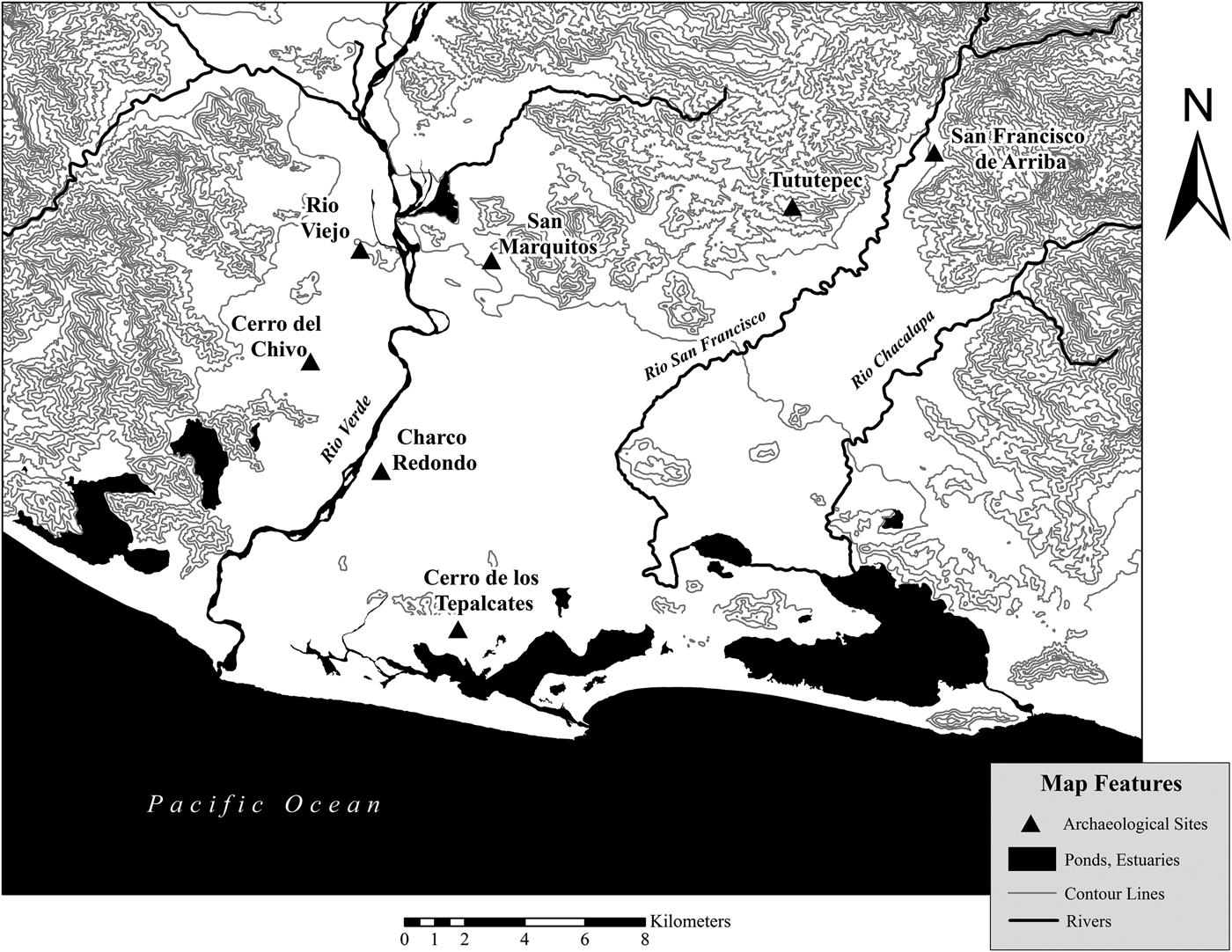
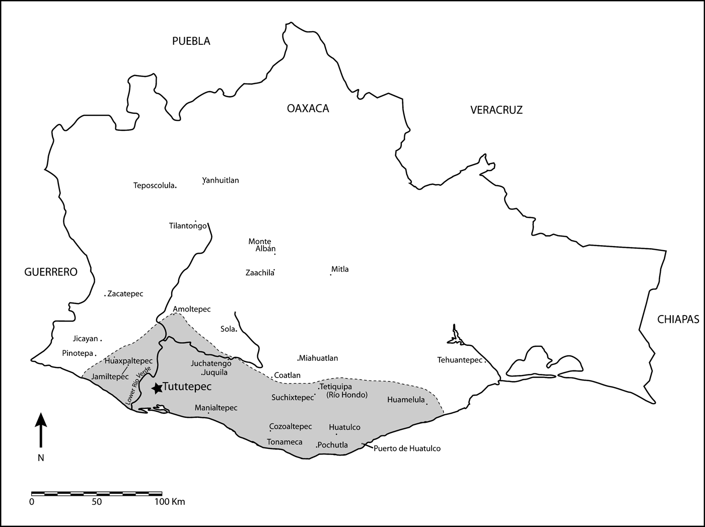
In this article, we examine the significance of domestic practices in the social and political transformations of the Postclassic period (a.d. 800–1522) in the lower Río Verde Valley on the Pacific coast of Oaxaca (Figure 1). We argue that following the collapse of Classic period (a.d. 250–800) political institutions and ruling dynasties, commoners experienced greater economic and political autonomy. Residential excavations at Río Viejo along with regional survey data indicate that during the Early Postclassic period (a.d. 800–1100) commoners took advantage of the absence of regional authority to gain greater control over surplus craft products, especially cotton thread, as well as access to social valuables and long-distance trade networks (Hedgepeth Reference Hedgepeth2009, Reference Hedgepeth2010; Joyce et al. Reference Joyce, Bustamante and Levine2001; King Reference King2003, Reference King and Blomster2008, Reference King2011). People may have also taken over ritual responsibilities that had once been the exclusive purview of the nobility. These economic and ritual practices were part of the everyday social setting in which new ruling dynasties emerged. By the beginning of the Late Postclassic period (a.d. 1100–1521), the region was once again dominated by powerful rulers centered on the city of Tututepec (Joyce et al. Reference Joyce, Workinger, Hamann, Kroefges, Oland and King2004). Yet household excavations show that Late Postclassic commoners continued to control some surplus craft production and had access to social valuables like copper and polychrome pottery via market exchange (Levine Reference Levine2007, Reference Levine2011). We argue that Late Postclassic political relations were a product of negotiations among elites and commoners that were influenced by the economic autonomy and political power non elites had acquired during the Early Postclassic period.
Map of the lower Río Verde Valley showing sites mentioned in the text.

To examine how everyday life contributed to political change during the Postclassic, we draw on a general approach informed by practice, feminist, and subaltern theories of social process (Bourdieu Reference Bourdieu1977; Butler Reference Butler1993; de Certeau Reference de Certeau1984; Giddens Reference Giddens1984; Ortner Reference Ortner and Ortner1996; Pred Reference Pred1990; Scott Reference Scott1990). These theoretical perspectives have contributed to recent archaeological approaches to social life and political change that seek to move beyond traditional neoevolutionary and structuralist theories (see, for example, Hodder and Hutson Reference Hodder and Hutson2003; Joyce Reference Joyce2010; Pauketat Reference Pauketat2001; Robin Reference Robin2002, Reference Robin2006). Archaeologists have generally viewed political change as driven by the strategic actions of social elites with little input from the less powerful (Flannery Reference Flannery1999; Martin and Grube Reference Martin and Grube2000). Although people like farmers, crafters, and cooks are seen as contributing to the economic base of society, in terms of far-reaching political transformations, common people are largely assumed to have passively acquiesced to the power of elites. There is also a tendency to view social change as episodic, triggered for the most part by momentous events such as warfare, natural disasters, and innovations in technologies and ideas (Carneiro Reference Carneiro1970; Kim Reference Kim2001; Ortloff and Kolata Reference Ortloff and Kolata1993; Ringle et al. Reference Ringle, Negrón and Bey1998; Spencer Reference Spencer2010). Again, archaeologists tend to view everyday practices, especially in household settings, as inconsequential for understanding political transformations. Although elite decision making during dramatic events like warfare and drought are often important to political change, we assert that without considering the agency of all people and the significance of everyday household practices, our understandings of social change will be incomplete.
This article considers the role of the everyday domestic practices of non elites in Postclassic period social change on the Oaxaca coast. We view social change as the outcome of negotiations among actors and coalitions with varying identities, interests, and worldviews (see also Hodder and Cessford Reference Hodder and Cessford2004; Hutson Reference Hutson2010; Janusek Reference Janusek2004; Joyce Reference Joyce2010; Joyce et al. Reference Joyce, Bustamante and Levine2001; Joyce and Lopiparo Reference Joyce and Lopiparo2005; King Reference King, Ardren and Hutson2006, Reference King2011; Levine Reference Levine2011; Pauketat Reference Pauketat2001; Robin Reference Robin2002; Yaeger Reference Yaeger and Smith2003). Approaches to social negotiation in archaeology have largely drawn on two theoretical perspectives: practice theory (for example, Bell Reference Bell1992; Giddens Reference Giddens1979, Reference Giddens1984; Ortner Reference Ortner and Ortner1996, Reference Ortner2006: Chap. 4; Pauketat Reference Pauketat2001) and rational choice theory (for example, Blanton and Fargher Reference Blanton and Fargher2008; Levi Reference Levi1981, Reference Levi1988). Scholars both within and across these two perspectives differ in a number of important ways including how rationality is addressed (Blanton and Fargher Reference Blanton and Fargher2008:15–18; Levi Reference Levi1981, Reference Levi1988; Ortner Reference Ortner1984:151–152); issues of methodological individualism (Giddens Reference Giddens1979:94–95; Levi Reference Levi1988:8; Ortner Reference Ortner and Ortner1996); the degree to which social negotiations involve strategic action and intentionality, especially by elites (Blanton and Fargher Reference Blanton and Fargher2008; Levi Reference Levi1988; Ortner Reference Ortner2006:134–137); and the degree to which cultural knowledge and material resources are considered to be distinct (Appadurai Reference Appadurai and Appadurai1986; Blanton and Fargher Reference Blanton and Fargher2008; Giddens Reference Giddens1984; Sewell Reference Sewell1992). Both perspectives can also be criticized in that many of their foundational works are focused on the study of states, particularly modern, Western ones. Despite their disparate theoretical foundations, we see an underlying similarity in the arguments of these two perspectives, which incorporate an understanding of political life in complex societies as historically and culturally contingent and as an outgrowth of negotiation among people and groups with divergent interests, identities, and power (see Joyce and Barber Reference Joyce and Barber2013a, Reference Joyce and Barber2013b). In addition, even though archaeologists have been drawing on these theorists for more than three decades and are increasingly invoking social negotiation as an important concept, we see relatively few sophisticated case studies that have successfully applied this concept with well supported empirical data from the archaeological record (Fargher et al. Reference Fargher, Blanton and Espinoza2010; Janusek Reference Janusek2004; Joyce Reference Joyce2010; Levine Reference Levine2011; Yaeger Reference Yaeger and Smith2003).
By negotiation, we refer to the manner in which social groups engage in intertwined social and material relations that affirm, modify, contest, or reject the terms of their relationships. The resulting obligations and rights that define these relationships can range from harmonious to discordant, cooperative to competitive, and symbiotic to exploitative. From this perspective, people's beliefs, knowledge, dispositions, and identities are constructed and transformed through social negotiations involving the people, places, and objects that are encountered and experienced daily (Hutson Reference Hutson2010). In turn, places and things come to take on or objectify ideas, including aspects of identity. Social elites may have more power in social negotiations, but outcomes always reflect some degree of compromise among social groups and individuals such that elites cannot simply impose their will on society. Elites must account for the fact that they are always outnumbered, and as many historical examples demonstrate, subordinates can at times transform or overthrow dominant ideas and institutions and establish new political regimes. We emphasize, however, that the social negotiations of interest to us and other postprocessual archaeologists go far beyond resistance and include everyday practices, both strategic and habitual, as well as more unusual acts including protest and rebellion (Hodder and Cessford Reference Hodder and Cessford2004; Janusek Reference Janusek2004; Joyce et al. Reference Joyce, Bustamante and Levine2001:368−370; Levine Reference Levine2011:23–24; Yaeger Reference Yaeger and Smith2003; [contra Carballo et al. Reference Carballo, Roscoe and Feinman2014:123; Feinman Reference Feinman and Carballo2013:303]).
We trace how everyday practice in domestic settings changed as a result of the collapse of the Late Classic Río Viejo polity and subsequent social developments in the Postclassic period. The absence of powerful rulers who controlled trade and commerce during the Early Postclassic period created opportunities in the realm of economic and perhaps ritual practices. The resulting changes in domestic life would also come to affect the negotiation of political relations during the Late Postclassic period, when a powerful ruling dynasty from the highlands took control of the region. Much of our data on everyday life in the Postclassic period comes from residential excavations at the sites of Río Viejo and Tututepec (Arnaud et al. Reference Arnaud, Joyce, Levine, Joyce and Levine2009; Hedgepeth Reference Hedgepeth2010; Joyce et al. Reference Joyce, Bustamante and Levine2001; King Reference King2003, Levine Reference Levine2007). At Río Viejo, a total of 12 residential structures were excavated from two areas of the site, although it was difficult to isolate specific households. At Tututepec, three households were excavated, including 10 distinct structures. In all cases, these structures were associated with domestic artifacts and features involving food preparation and cooking, craft production, especially of textiles, and trade. Although our evidence is limited to a relatively small number of residences, the data provide important insights into daily practice and its relationship to political change. First, we summarize evidence for political organization during the Late Classic period as a prelude to examining the dramatic changes that occurred at the beginning of the Postclassic period.
LATE CLASSIC RIÍO VIEJO AND THE HISTORICAL ROOTS OF POSTCLASSIC SOCIETY
The lower Río Verde Valley has been a focus of archaeological fieldwork over the past 28 years (see summaries in Joyce Reference Joyce2005, Reference Joyce2010, Reference Joyce2013). Archaeological excavations have been carried out at 19 sites, including horizontal and/or block excavations at eight of these (Barber Reference Barber2005; Barber and Joyce Reference Barber and Joyce2011; Joyce Reference Joyce1991, Reference Joyce1999, Reference Joyce2010; Joyce and Levine Reference Joyce and Levine2009; King Reference King2003; Levine Reference Levine2007; Workinger Reference Workinger2002). A full-coverage regional survey has been conducted over 164 km2, which represents about one-third of the valley (Hedgepeth and Koukopoulous Reference Hedgepeth, Koukopoulos, Barber and Joyce2012; Joyce et al. Reference Joyce, Workinger, Hamann, Kroefges, Oland and King2004; Workinger Reference Workinger2002), and paleoecological research has addressed landscape change and its relationship to settlement patterns (Goman et al. Reference Goman, Joyce, Mueller and Paschyn2010). We begin with a summary of evidence for the Late Classic period, which was the historical setting from which Postclassic society developed.
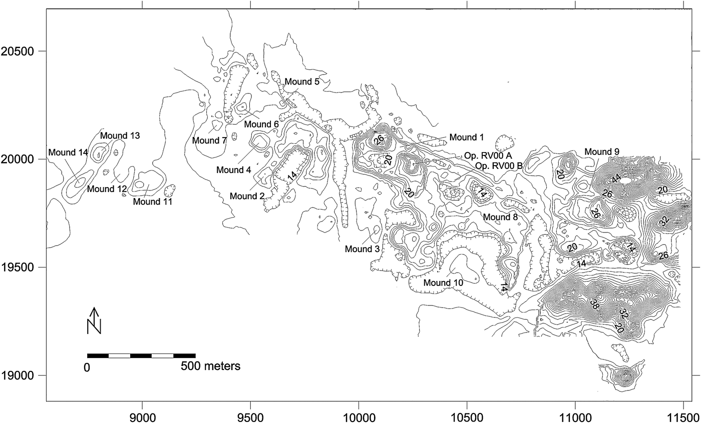
The majority of data on Late Classic (a.d. 500–800) society in the lower Río Verde Valley comes from the regional survey and from excavations at the site of Río Viejo (Figure 2). During the Late Classic period, the lower Verde was dominated by a complex regional polity centered at Río Viejo, which covered 250 ha in the floodplain west of the river (Joyce Reference Joyce and Blomster2008; Joyce et al. Reference Joyce, Bustamante and Levine2001; Joyce and Barber Reference Joyce and Barber2011). A total of 682 ha, primarily located in the floodplain, has been recorded within the full-coverage survey zone. Other prominent Late Classic sites like San Francisco de Arriba, Charco Redondo, and Cerro del Chivo, ranged in size from 26 to 58 ha and featured monumental buildings and carved stone monuments.
Plan of Río Viejo showing locations of the Acropolis and Operations A and B (after Joyce et al. Reference Joyce, Bustamante and Levine2001:Figure 3).
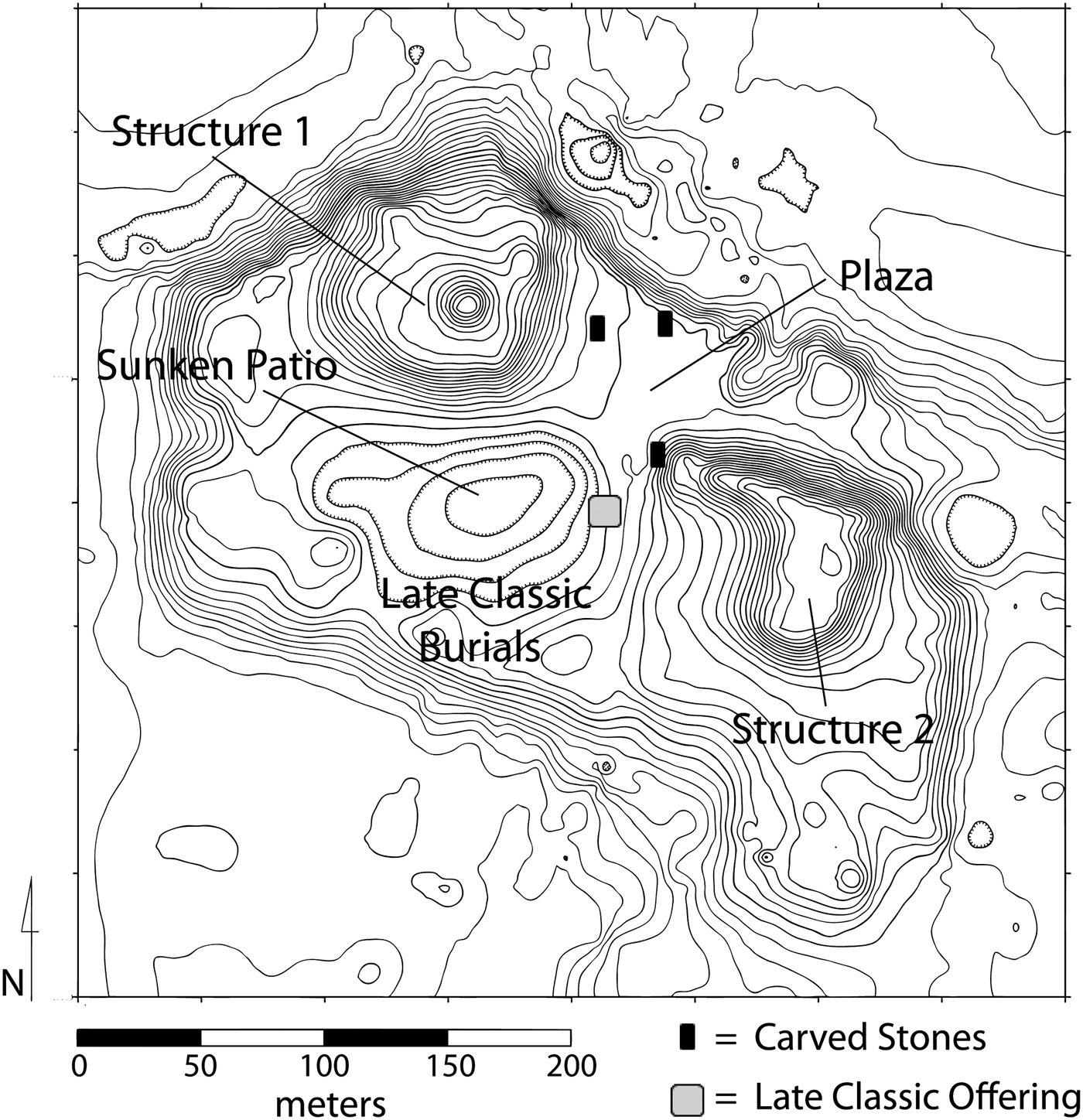
During the Late Classic period, Río Viejo's massive acropolis, which had been abandoned at the end of the Formative period, was reoccupied (Joyce and Barber Reference Joyce and Barber2011). A major building project was initiated that joined the acropolis with several smaller structures thereby expanding the total area of the building to 350 × 200 m (Figure 3). Extensive excavations (Barber and Joyce Reference Barber and Joyce2011, Reference Barber and Joyce2012; Joyce and Barber Reference Joyce and Barber2011; Joyce and Levine Reference Joyce and Levine2009) have raised questions concerning the Late Classic use of the acropolis. Once assumed to have been the site's administrative center (Joyce Reference Joyce, Brown and Stanton2003), excavations failed to find evidence of a ruler's residence or impressive standing architecture. In fact, the only evidence of Late Classic superstructures consists of several poorly preserved stone foundations of only one-or-two courses and a burned wattle-and-daub superstructure (Barber and Joyce Reference Barber and Joyce2012; Levine and Joyce Reference Levine, Joyce, Joyce and Levine2009). Rather than finding evidence for activities associated with elite residences or public buildings, the excavation results suggest that the acropolis was used primarily for commemorative ceremonies involving the interment of human burials and other offerings as well as the installation of carved stone monuments and ritual feasting (Baillie Reference Baillie2012).
Plan of the Acropolis at Río Viejo with contour intervals at .5 m (after Joyce Reference Joyce2005:Figure 6).
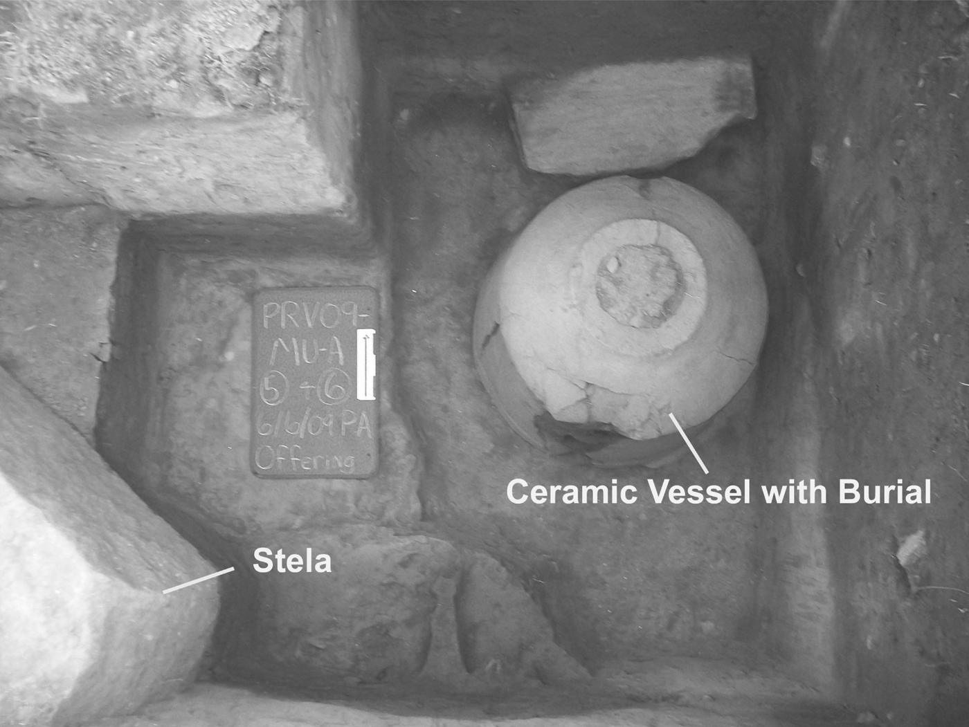
Near the center of the acropolis, excavations exposed a complex offering including two plain stelae and three large ceramic vessels containing burials that date to the beginning of the Late Classic reoccupation of the acropolis (Brzezinski et al. Reference Brzezinski, Joyce, Lucido, Barber and Joyce2012; Joyce and Barber Reference Joyce and Barber2011) (Figure 4). Each of the three large vessels was surrounded by several smaller ceramic vessels. A cluster of four additional vessels may mark a fourth corner that completes a quadripartite pattern making symbolic reference to the sacred cosmos (see López Austin and López Luján Reference López Austin, Luján and Uriarte2004). At least four burials were found on the eastern side of the offering, and to the west were dense deposits of cut and burned human bone as well as several articulated skeletons and smaller quantities of animal bone (preliminary bioarchaeological analyses have been carried out on all of the burials described herein and more detailed studies of diet, health, and nutrition are in process). Four other articulated human burials may have been part of the offering, although their association is less clear. This complex offering represents the earliest activity carried out on the acropolis in the Late Classic period, and reflects rituals designed to reactivate the acropolis upon its reoccupation.
A large ceramic vessel containing a burial from the Late Classic offering on the Acropolis at Río Viejo.
To the north of the complex offering, three carved stone monuments, as well as several uncarved monuments, were erected (Urcid and Joyce Reference Urcid and Joyce2001). Two of the carved stones depict elaborately costumed nobles, which probably represent rulers at Río Viejo (Figure 5). A third carved stone depicts only a calendrical glyph (2-Jaguar), which probably represents the name of a ruler (two monuments located elsewhere at the site also reference a probable ruler with the same name; one of these depicts an image of the person).
Río Viejo Monument 8 (after Joyce et al. Reference Joyce, Bustamante and Levine2001:Figure 4).
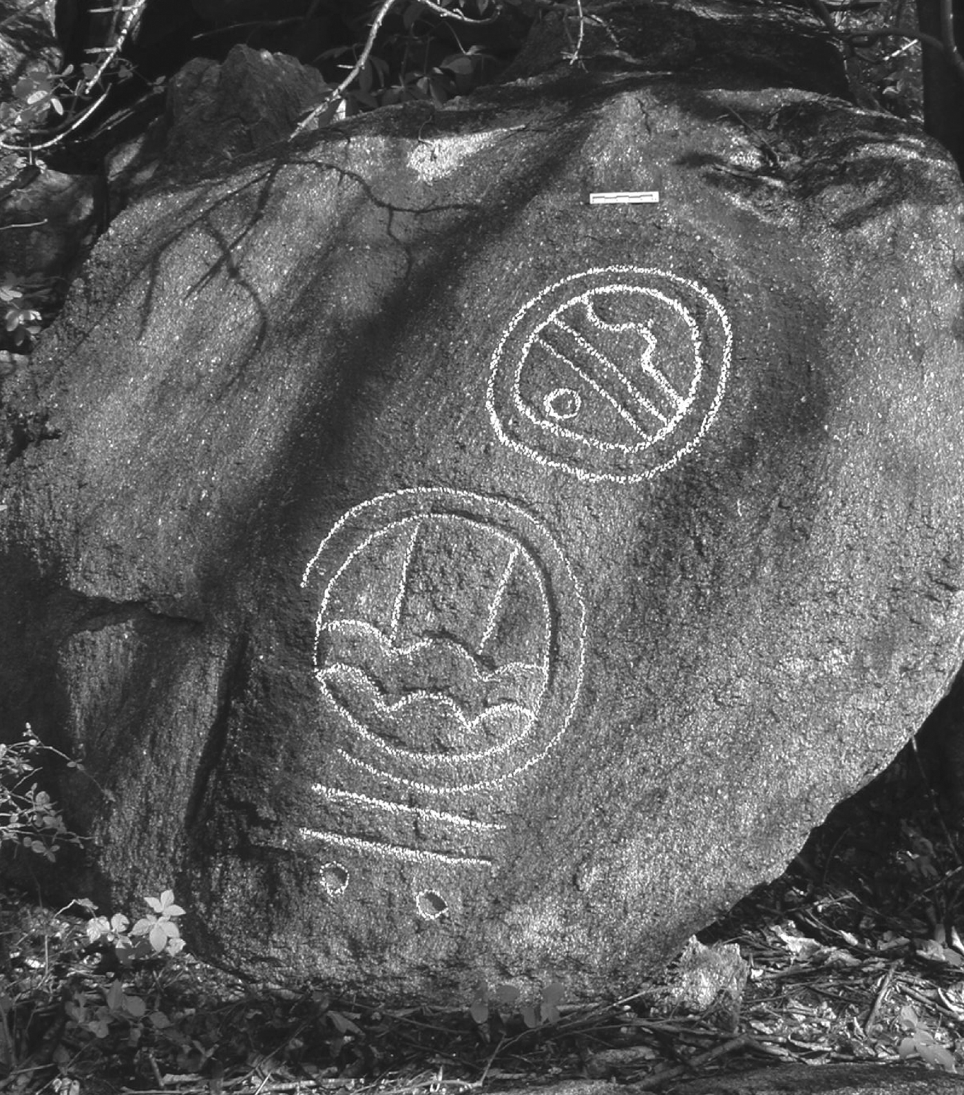
In the southern half of the acropolis, south of the complex offering, excavations exposed 20 human burials accompanied by few or no offerings. Unlike typical ceremonial centers in other parts of Classic-period Mesoamerica, none of the burials on the acropolis suggest the interment of nobles. The only evidence thus far in the region for the burial of high-status people comes from the site of Cerro de los Tepalcates, located on a rocky hill that overlooks the coastal estuaries. At this site, hieroglyphic inscriptions that appear to be calendrical names of rulers were carved into boulders (Figure 6) and the remains of a probable looted tomb were discovered (Joyce et al. Reference Joyce, Bustamante and Levine2001:351–353). Since no tombs have been found elsewhere in the region, these data suggest that rulers may have been interred outside their communities at sacred nonresidential sites.
Hieroglyphic names carved into boulders at Cerro de los Tepalcates (after Joyce and Forde Reference Joyce and Forde2014:Figure 6).
Beyond evidence dealing with public ceremony and nobles, relatively little is known about life in the Late Classic period. Most of the remaining data come from non elite burials and a few domestic features in test excavations (Joyce Reference Joyce1999; Joyce and Levine Reference Joyce and Levine2009). Based on these data, non elites were mostly farmers, although specialized production of gray ware pottery comes from kiln wasters recovered in excavations and surface collections on Mound 4 at Río Viejo. People were buried as individuals or in small family groups in household settings. Most burials lacked offerings or were accompanied by a few ceramic vessels and, occasionally, objects such as ground stone axes, shell beads, worked bone, and greenstone beads.
Overall, the data demonstrate that during the Late Classic period, Río Viejo was the dominant political center in the lower Río Verde Valley. Río Viejo shared many features with other centralized regional polities in Classic-period Mesoamerica including urbanism, monumental art and architecture, writing, and the institution of dynastic rulership. Nonetheless, like most Classic-period polities, the data also show that rulers and ruling institutions collapsed at approximately a.d. 800. As we discuss in the next section, the collapse of regional political authority at the end of the Classic period created economic and ritual opportunities for people in the Early Postclassic that had long-term social and political ramifications.
ECONOMIC PRACTICE AND POLITICAL TRANSFORMATION IN EARLY POSTCLASSIC RíO VIEJO
As noted above, archaeological data demonstrate that the Río Viejo polity collapsed at approximately a.d. 800 (Joyce Reference Joyce and Blomster2008; Joyce et al. Reference Joyce, Bustamante and Levine2001). Río Viejo decreased in size from 250 ha during the Late Classic period to 140 ha by the Early Postclassic period. At the same time, the site of San Marquitos, located across the river from Río Viejo, grew to 191 ha in the Early Postclassic period from 7 ha in the Late Classic period. The regional population, as measured by the occupational area in the full-coverage survey, decreased from 682 ha in the Late Classic to 507 ha in the Early Postclassic, and the focus of settlement moved from the floodplain into the piedmont. Settlement was also much more nucleated in the Early Postclassic period than it had been in earlier times, with 52% of the occupational area located within 3 km of San Marquitos.
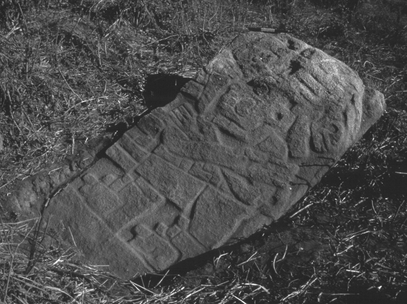
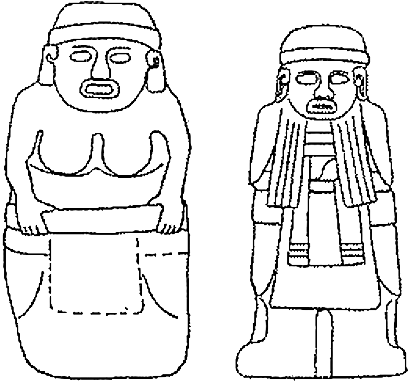
Evidence for the political collapse includes a cessation of the construction and use of monumental buildings that would have housed rulers and ruling institutions. There was also a decrease in monumental art with only three carved stones dating to the Early Postclassic period based on stylistic grounds (Urcid and Joyce Reference Urcid and Joyce2001). Early Postclassic monuments depict individuals without the hieroglyphic names or the elaborate attire so commonly found on Late Classic carved stones (Figure 7). The Early Postclassic monuments were located on top of a natural hill at the eastern end of Rio Viejo, unlike earlier monuments, which were associated with public spaces and a possible elite residence. For these reasons, Urcid and Joyce (Reference Urcid and Joyce2001:211) suggest that the Early Postclassic monuments may depict deities rather than rulers.
Early Postclassic period monuments at Río Viejo (after Joyce et al. Reference Joyce, Bustamante and Levine2001:Figure 4).
Excavations indicate that by the Early Postclassic period, people living at Río Viejo were no longer treating earlier sacred spaces and monumental art with the same reverence they had been afforded previously. Excavations in two areas at Río Viejo in 2000 yielded data for the possible dismantling and destruction of buildings and monumental art that had been symbols of Late Classic rulership (Joyce et al. Reference Joyce, Bustamante and Levine2001). One area (Operation A) was located on top of a large superstructure (Mound 1, Structure 2) located on the eastern end of the acropolis. During the Late Classic period, the acropolis was a public ceremonial space symbolizing the sacred cosmos and celebrating the power of rulers in monumental art. During the Early Postclassic period, however, commoners constructed their houses on the acropolis utilizing stone dismantled from the foundations of Late Classic buildings on Structure 2.
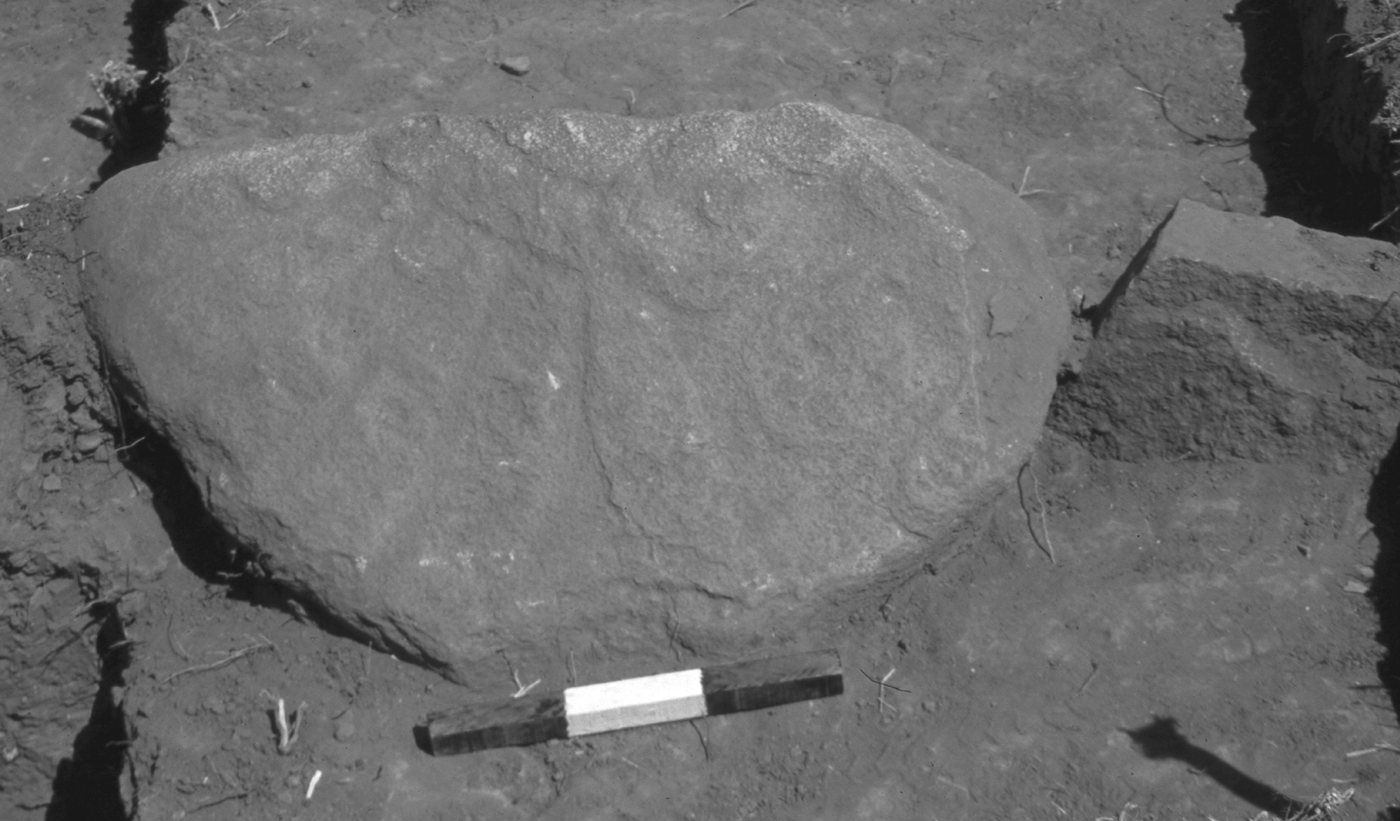
The second area (Operation B) was located on Mound 8, approximately 180 m southeast of the acropolis (King Reference King2003). In Operation B, a Late Classic carved stone (Monument 17) was re-utilized in the wall foundation of an Early Postclassic low-status house (King Reference King2003:188–190). The stone depicts a noble with an elaborate feathered headdress (Figure 8). Before the residents placed the carved stone in the wall of the house, the monument had been broken and the back side was reused as a metate. Since representations of nobles in Mesoamerica were often interpreted as the living manifestations of those persons, placing a ruler's portrait face down on the ground while grinding would have been an especially powerful symbolic act (Just Reference Just2005). It is unlikely that only a few generations after the collapse of the Río Viejo polity that the earlier meanings of these monuments would have been lost and they would simply have been considered as convenient building materials (see Hamann Reference Hamann and Blomster2008; Joyce Reference Joyce and Blomster2008:239–240). In appropriating earlier monumental art and architecture in everyday acts like grinding corn or building houses, it is likely that people were constructing new identities based in part on references to the reworked meanings and symbols of the past (King Reference King2005). The evidence also suggests that Early Postclassic people were expressing dissatisfaction with the rulers and ruling institutions that had dominated the region just a few generations before, raising the possibility that social unrest by non elites contributed to the collapse of political authority at the end of the Classic period (see Joyce et al. Reference Joyce, Bustamante and Levine2001; Joyce and Weller Reference Joyce, Weller, Gonlin and Lohse2007).
Photograph of Monument 17, Operation B at Río Viejo (after Joyce and Forde Reference Joyce and Forde2014:Figure 49).
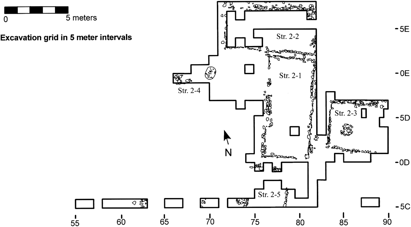
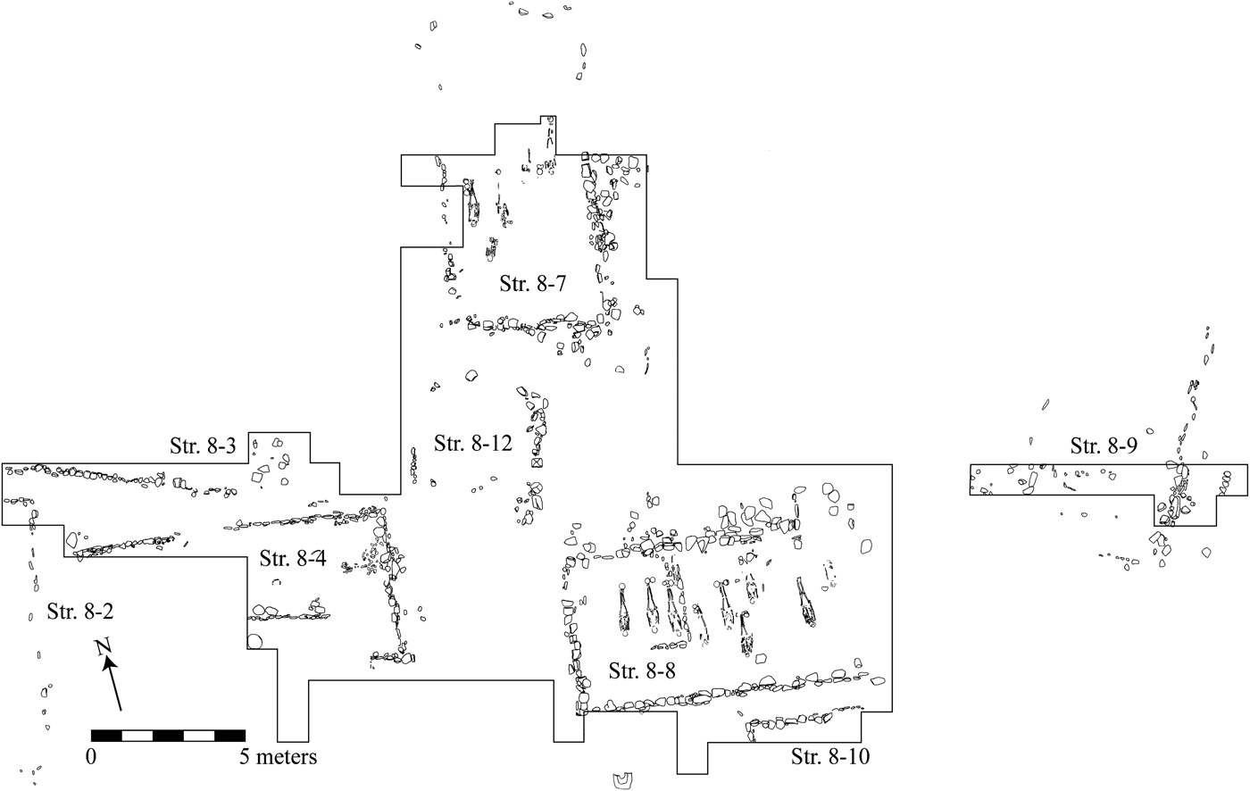
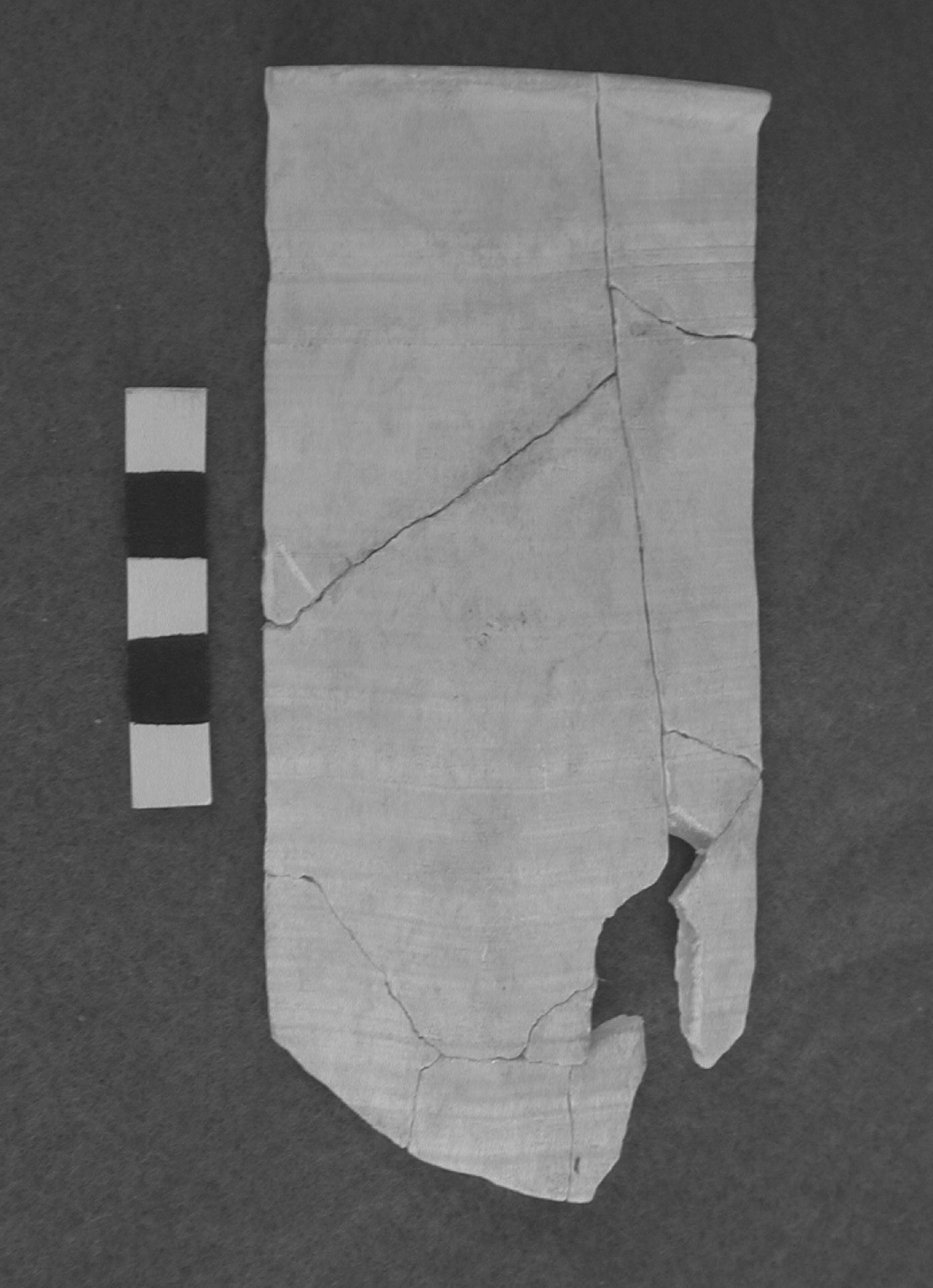
The evidence from the excavations at Operations A and B indicate that the Early Postclassic period was a time of significant change in the daily lives of Río Viejo's residents (Hedgepeth Reference Hedgepeth2009; Joyce et al. Reference Joyce, Bustamante and Levine2001; King Reference King2003). Operation A exposed 242 m2, including two houses that were completely excavated, portions of three other houses, and a patio (Figure 9). Operation B exposed 284 m2, including two houses that were completely excavated and portions of five others (Figure 10). The structures evident in both operations were low platforms, measuring approximately 11 × 5 in area and standing roughly .5 m high, which supported wattle-and-daub superstructures. The size and form of the buildings in both areas were virtually identical, and the relatively modest architecture and burial offerings indicate commoner status. Dozens of similar structures have been observed on the surface over a broad area of Mound 8 and in other parts of the site. Recent excavations in the western end of the acropolis have exposed additional low platforms dating to the very end of the Late Classic or the beginning of the Postclassic period, and these appear similar in size and form to those of Operations A and B (Barber and Joyce Reference Barber and Joyce2012). The excavations at Río Viejo along with the regional survey data suggest little variation in wealth and status during the Early Postclassic period, although additional sampling is needed to confirm this pattern. Artifacts and features associated with the buildings indicate everyday domestic practices such as food processing and consumption, working of lithics, thread manufacture, ceramic production, bodily ornamentation, and domestic rituals (Arnaud et al. Reference Arnaud, Joyce, Levine, Joyce and Levine2009; Hedgepeth Reference Hedgepeth2009; Joyce et al. Reference Joyce, Bustamante and Levine2001; King Reference King2003, Reference King2011; Williams Reference Williams2012). The evidence also shows that people participated in long-distance trade. Imported goods included obsidian recovered from both excavation areas (King Reference King and Blomster2008; Levine et al. Reference Levine, Joyce and Glascock2011), as well as two greenstone beads, a small turquoise pendant, pieces of pumice, and fragments of at least two alabaster vessels from Operation A (Figure 11).
Plan of structures exposed in Operation A at Río Viejo (after Joyce et al. Reference Joyce, Bustamante and Levine2001:Figure 7).
Plan of structures exposed in Operation B at Río Viejo (after King Reference King and Blomster2008:Figure 8.3).
Fragment of an alabaster vessel recovered in Operation A at Río Viejo.
The absence of powerful rulers and political institutions created opportunities for Early Postclassic people living at Río Viejo and elsewhere in the region. These opportunities ushered in a host of changes in domestic life, especially those related to ritual and economic practices (Hedgepeth Reference Hedgepeth2009; Hedgepeth Balkin et al. Reference Hedgepeth Balkin, Joyce, Goman and Barber2014; Joyce et al. Reference Joyce, Bustamante and Levine2001; King Reference King2003, Reference King2011; Levine et al. Reference Levine, Joyce and Glascock2011). There is evidence for an expansion in domestic craft production relative to earlier periods, including the manufacture of thread and textiles, pottery, stone tools, and ceramic figures (Hedgepeth Reference Hedgepeth2009; King Reference King2003, Reference King2011; Williams Reference Williams2012). Obsidian blades were produced from imported polyhedral cores and chert tools were made from local river cobbles or imported cores (Hedgepeth Reference Hedgepeth2009:171–179; King Reference King2003:292–298; Williams Reference Williams2012:85). Both areas (Hedgepeth Reference Hedgepeth2009:169–170; King Reference King2003:317–332) yielded evidence for pottery production, including quartz burnishing stones and ceramic pestles used in pottery manufacture (see Houston and Wainer [Reference Houston and Wainer1971], who refer to these pestles as azotadores). A sherd from a misfired vessel was also recovered from one of the middens in Operation A. In Operation B, King (Reference King2003:321) discovered fragments of six molds used to manufacture ceramic figurines. The excavation data from Río Viejo, coupled with the discovery of pottery-making pestles in many Early Postclassic sites in the surface survey, suggest that ceramic production took place at many communities in the valley. These data contrast with the limited Late Classic evidence for specialized production of gray wares on Mound 4 located about 400 m west of the acropolis.
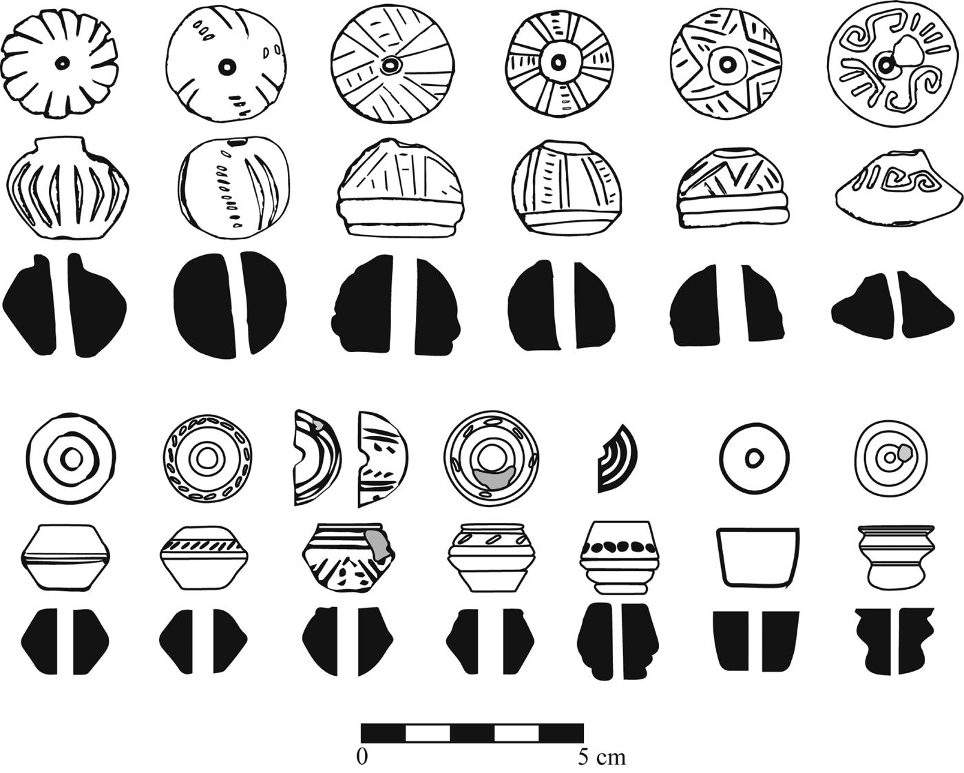
Ceramic spindle whorls from Operation A and B residences represent the most common evidence for craft production in the Early Postclassic period (Hedgepeth Reference Hedgepeth2009; King Reference King2003, Reference King2011). Bone needles and clay stamps, perhaps used to weave and decorate cloth, have also been found. As demonstrated by King (Reference King2003:300–310, Reference King2011), the dimensions of the Early Postclassic spindle whorls from Río Viejo indicate that they were used exclusively in the production of cotton thread (Figure 12). Spindle whorls have also been recovered from many Early Postclassic sites recorded in the regional survey, indicating that thread production was widespread. The lower Verde region has ideal environmental conditions for cotton production and during the Colonial period, and more recently, was one of the most important cotton-producing regions in Oaxaca (Rodríguez Canto Reference Rodríguez Canto1996). The Early Postclassic is the first period in the region when evidence for spinning and weaving is common, although a small number of ceramic discs recovered from earlier contexts may represent spindle whorls. Overall, the impression is that domestic craft production increased considerably from the Late Classic to the Early Postclassic period.
Ceramic spindle whorls from the lower Río Verde Valley. Top row: Early Postclassic whorls from Río Viejo (after King Reference King and Blomster2008:Figure 8.10); bottom row: Late Postclassic whorls from Tututepec (after Heijting Reference Heijting2006).
In addition to an expansion in craft production, the evidence indicates that the absence of powerful rulers during the Early Postclassic period allowed people greater and more direct access to long-distance trade routes (Hedgepeth Reference Hedgepeth2009, Reference Hedgepeth2010; Joyce et al. Reference Joyce, Bustamante and Levine2001; King Reference King and Blomster2008, Reference King2011; Levine et al. Reference Levine, Joyce and Glascock2011). The most common imported material was obsidian, although, as mentioned above, small quantities of greenstone, turquoise, alabaster, and pumice also reached the region. Hundreds of pieces of obsidian, mostly prismatic blades, were recovered from both areas at Río Viejo. More obsidian was recovered in the Operation A middens, which yielded 47 obsidian artifacts/1,000 ceramic rim sherds (Hedgepeth Reference Hedgepeth2009: Table 5–9), than the Operation B excavations that yielded 22 obsidian artifacts/1,000 rim sherds.
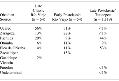
Table 1 presents the results of sourcing studies of obsidian from Late Classic and Early Postclassic contexts at Río Viejo, as well as Late Postclassic residences at Tututepec (Joyce et al. Reference Joyce, Elam, Glascock, Neff and Winter1995; Levine et al. Reference Levine, Joyce and Glascock2011). Obsidian was sourced using a combination of x-ray fluorescence (XRF), instrumental neutron activation analysis (INAA), and visual sourcing of Pachuca and Pico de Orizaba obsidian. The Late Classic sample includes obsidian from middens in the sunken patio on the acropolis (n = 38), the base of the acropolis (n = 5), and from domestic contexts in the eastern end of the site (n = 11). The obsidian from Late Classic contexts represents either 100% samples or randomly selected subsamples. The Early Postclassic sample comes from two midden deposits in Operation A, where all of the recovered obsidian was sourced (Levine et al. Reference Levine, Joyce and Glascock2011; Williams Reference Williams2012). The obsidian evidence indicates trade relations with west Mexico (Ucareo), the central Mexican highlands (Pachuca, Otumba, Zacualtipan, Paredon), and the mountains overlooking the Gulf coast (Zaragoza, Pico de Orizaba, Guadalupe Victoria). With the exception of Zacualtipan and Guadalupe Victoria, materials from these sources were widely distributed during the Early Postclassic period (Braswell Reference Braswell, Smith and Berdan2003:Table 20.1). Ucareo, representing the most common source in our Río Viejo sample, was also a major source for obsidian found at the Epiclassic and Early Postclassic centers of Tula in the northern Basin of Mexico and Xochicalco in Morelos, while Zaragoza was an important source for obsidian at the site of Cholula in the Puebla-Tlaxcala Valley (Braswell Reference Braswell, Smith and Berdan2003:Table 20.1; Healan Reference Healan1993:454; Ringle et al. Reference Ringle, Negrón and Bey1998:222; Sorensen et al. Reference Sorensen, Hirth, Ferguson, Gaxiola and Clark1989). In the Late Classic sample, there is a difference in sources from public contexts (middens associated with the acropolis) and non elite domestic contexts. In the sample from the acropolis, 65% of the obsidian derives from Ucareo and 23% from Pachuca, while the corresponding frequencies from non elite contexts are 20% and 10%, respectively. These data suggest that Late Classic elites may have had preferential access to exchange networks involving the movement of Ucareo and Pachuca obsidian. Although the percentages of obsidian from different sources are fairly consistent from the Late Classic to the Early Postclassic, there appears to be a general shift through time toward the east with sources like Zacualtipan, Zaragoza, and Pico de Orizaba increasing, and Ucareo and Pachuca decreasing. This shift may represent increasing trade and interaction with the urban center of Cholula.
Lower Río Verde Valley Obsidian Sources
a Initially all of the obsidian was visually sourced with a total of 476 pieces attributed to Pachuca and 609 to Orizaba. A total of 99 pieces of obsidian were then sourced through XRF, including 30 of the 34 pieces whose source was undetermined visually as well as 8 pieces visually attributed to Pachuca and 51 visually attributed to Orizaba. None of the visually undetermined pieces were sourced via XRF to either Pachuca or Orizaba and all of the visually sourced pieces attributed to Pachuca and Orizaba were correctly sourced (see Levine [Reference Levine2007:385–389] for a detailed discussion of the visual sourcing methodology).
The obsidian data generally correspond to stylistic crossties between Early Postclassic ceramics in the lower Verde and other regions suggesting that ideas as well as materials may have been exchanged (Hedgepeth Reference Hedgepeth2009:204–218; Joyce et al. Reference Joyce, Bustamante and Levine2001:375–378; King Reference King and Blomster2008:271–273). Although lower Verde ceramic styles are regionally distinctive, there are ties with ceramics from Cholula (McCafferty Reference McCafferty1992, Reference McCafferty1996) and Tula (Cobean Reference Cobean1990; Diehl Reference Diehl1983:102–109) in the central Mexican highlands along with the Valley of Oaxaca (Markens Reference Markens2004) and the Mixteca Alta (Spores Reference Spores1972) in the Oaxacan highlands. Hedgepeth (Reference Hedgepeth2009:204–218) shows that certain designs on Early Postclassic pottery, especially the star/flower motif, suggest that people in the lower Verde had some knowledge of the Quetzalcoatl Cult that was associated with rulership in many regions of Mesoamerica at this time (Ringle et al. Reference Ringle, Negrón and Bey1998). The people at Río Viejo, however, adopted and transformed these ideas for local domestic ceremonial purposes (compare against Kopytoff Reference Kopytoff and Appadurai1986). Avian imagery found on figurines and pottery vessels also likely reflects widely shared Mesoamerican cosmological beliefs involving the flowery sacred world inhabited by ancestors and filled with birds and butterflies (King and Sánchez Santiago Reference King and Sánchez Santiago2011). Taken as a whole, however, the imagery on figurines exhibits their strongest stylistic crossties with the Gulf coast (Jennings Reference Jennings2010:109–112).
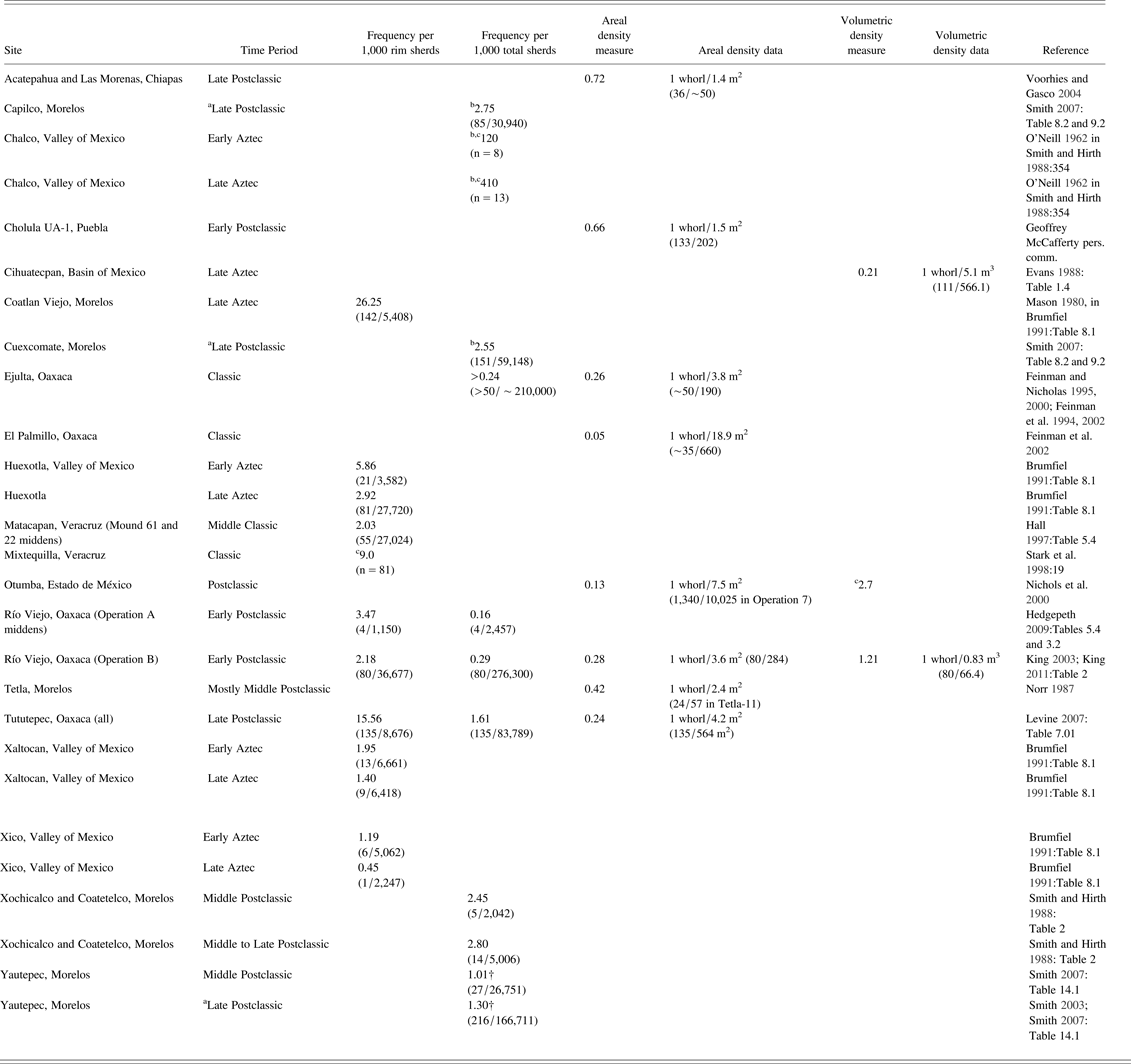
The most likely item traded in exchange for non local goods was cotton, either in its raw form or as thread or cloth (mantas). At the time of the Spanish Conquest, cotton was a highly valued and sought after material throughout Mesoamerica (Anawalt Reference Anawalt1980, Reference Anawalt1981; Berdan Reference Berdan1987; Hamann Reference Hamann, Claassen and Joyce1997; Hicks Reference Hicks, Hodge and Smith1994). It was the most common item requested in tribute by the Aztec empire and was used as a form of currency (Berdan et al. Reference Berdan, Masson, Gasco, Smith, Smith and Berdan2003:101–102). The Relaciones Geográficas show that the lower Verde was a major exporter of cotton during the Late Postclassic and Early Colonial periods (Acuña Reference Acuña1984:220, 272; Paso y Troncoso Reference Paso y Troncoso1905:204). Table 2 shows various measures of spindle whorl frequencies from sites in Mesoamerica (see King [Reference King and Sánchez Santiago2011] for a discussion of the advantages and disadvantages of different measures of spindle whorl frequency).
Spindle whorl density measures calculated in various ways: frequency of whorls to 1,000 rim sherds and total sherds, density per square meter (areal), and density per cubic meter (volumetric)
aEarly and Late Cuauhnahuac combined.
bFrequency per total ceramic artifacts.
cPartial or no raw numbers published.
Assuming that spindle whorl frequency can be used as a proxy for thread production, the data indicate that the productivity of spinners at Río Viejo was comparable to or exceeded that found at most other sites prior to the ascent of the Aztec empire when cloth production generally increased (Brumfiel Reference Brumfiel, Gero and Conkey1991; Levine Reference Levine2007:345). Since some of the highland sites in the sample were also manufacturing less-valued maguey fiber (Brumfiel Reference Brumfiel, Gero and Conkey1991:232), the production of cotton thread was probably even greater at Río Viejo relative to other sites listed in Table 2. Based on comparative data, we argue that people at Río Viejo made thread from local cotton in excess of what was needed for household consumption and traded raw and processed cotton for highland products, especially obsidian (see King Reference King2003, Reference King2011:332; but compare against Hedgepeth Reference Hedgepeth2009:186–187). The data suggest that by the Early Postclassic period, people at Río Viejo and probably elsewhere in the region were freed from tax payments to rulers, allowing them to use surplus production to acquire goods directly through long-distance trade. Imports included obsidian, but also a smaller quantity of semi-precious stones such as alabaster, greenstone, and turquoise. In addition to cotton, ethnohistoric sources indicate that feathers, salt, animal pelts, palm oils and fibers, and cacao, among other items, were exported by people on the Oaxaca coast (Byland and Pohl Reference Byland and Pohl1994; Feinman and Nicholas Reference Feinman, Nicholas, Schortman and Urban1992; Joyce Reference Joyce1993; King Reference King and Blomster2008:255; Monaghan Reference Monaghan, Marcus and Zeitlin1994; Spores Reference Spores1993). Given that these items are perishable and their production leaves few archaeological traces, it is difficult to evaluate their importance in Early Postclassic trade.
The absence of powerful rulers may have also allowed people at Río Viejo to engage directly with forms of religious expression that were inaccessible to them during the Late Classic period. Evidence from the residential excavations at Río Viejo and from surface survey show that religious ritual in the Early Postclassic period involved mortuary ceremonies as well as the use of figurines and musical instruments including whistles and flutes, which largely show continuity with Late Classic patterns (Baillie Reference Baillie2012:139–141; Jennings Reference Jennings2010; Joyce Reference Joyce2010:246, 254–255; King Reference King, Ardren and Hutson2006, Reference King2011). Offerings associated with Early Postclassic burials were similar to those found in Late Classic interments and typically included one to three ceramic vessels, although some bodies had additional offerings, such as quartz axes, obsidian blades, and shell ornaments (King Reference King2003:194–198, Reference King, Ardren and Hutson2006, Reference King2011). Although most of the evidence for domestic ritual shows continuities between periods, the excavations in Operation A at Río Viejo suggest that Early Postclassic people living on the acropolis took over ritual responsibilities that had been the exclusive purview of the nobility during the Late Classic period.
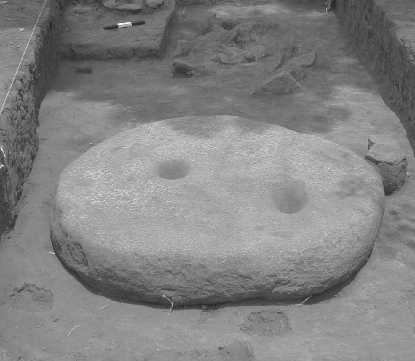
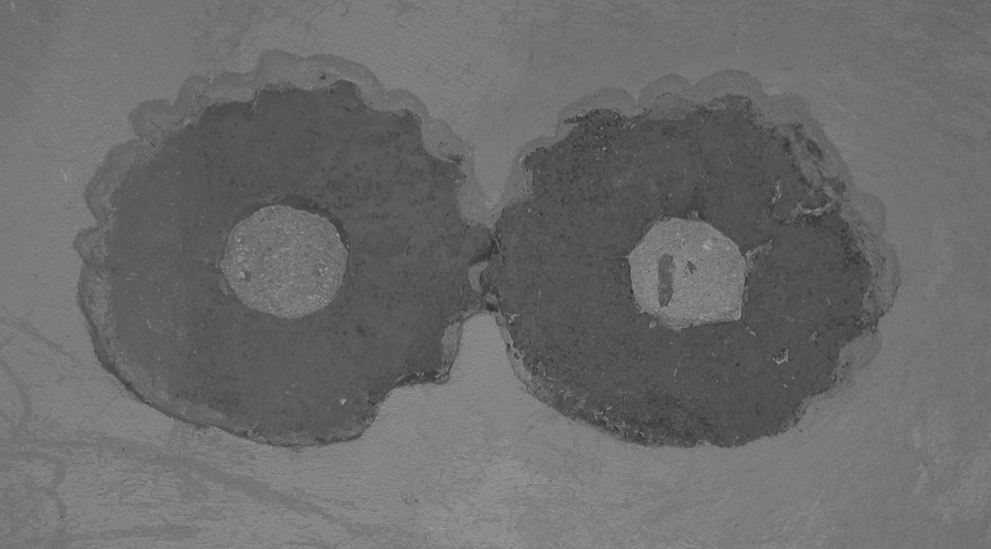
Excavations exposed a worked monolith measuring 1.42 × 1.09 × .48 m laying on the surface of the patio in Operation A (Arnaud et al. Reference Arnaud, Joyce, Levine, Joyce and Levine2009; Joyce et al. Reference Joyce, Bustamante and Levine2001). The stone's surface had 15 ground depressions similar to those observed on other worked monumental stones and unworked boulders at the site (Urcid and Joyce Reference Urcid and Joyce2001:205–208). The function of these stones is unclear, although they could have been used for grinding or collecting unidentified materials in ritual contexts (Figure 13). A ceremonial use is suggested by the presence of a multiple burial interred 1.25 m to the east of the monolith. This burial included two individuals placed in a pit partially lined with stones; neither was accompanied by offerings. The first individual to be interred was a secondary burial of an adult male whose bones exhibited cut marks (Urcid Reference Urcid2000). Prior to burial beneath the patio—which would have been the second inhumation of this individual—some of the bones were painted with red pigment and burned at low temperatures. The fill in the burial pit also included ash and charcoal indicative of burning. The second individual was a primary interment of an adult female in a seated and tightly flexed position, probably representing a bundle burial, and placed directly on top of the first individual. After the burial was covered with sediment, a fire was set over the grave leaving a layer of burned earth on the surface.
Stone monument from the Patio in Operation A at Río Viejo (after Joyce et al. Reference Joyce, Bustamante and Levine2001:Figure 9a).
The evidence from the patio in Operation A recalls the Late Classic offering in the center of the acropolis with its deposits of burned and cut human bone along with unburned articulated skeletons buried beneath at least two uncarved stelae. The scale and setting of the Late Classic ritual deposits, coupled with imagery on some of the rulers' portraits referencing human and autosacrifice (Urcid and Joyce Reference Urcid and Joyce2001), suggest that the Late Classic rituals involving the emplacement of these offerings were sponsored and led by powerful nobles. The evidence for Early Postclassic ceremony was much smaller in scale and focused in the Operation A residences, rather than in an accessible, public setting as was the Late Classic ritual. Overall, the data suggest some continuity in ceremonies performed on the acropolis, but in the context of very different social and spatial settings. The presence of large numbers of flutes, whistles, bells, costume ornaments, and ceramic vessels with rattle supports from the Early Postclassic houses (King and Sánchez Santiago Reference King and Sánchez Santiago2011) might also reflect the appropriation of Late Classic ceremonies associated with ritual feasting (see Baillie Reference Baillie2012). The data on Late Classic commoner ritual is insufficient to determine if similar sorts of musical instruments and noise-makers were associated with Late Classic commoners, however.
Overall, the data indicate that the collapse of rulers and ruling institutions gave Early Postclassic people greater flexibility and control over their economic and ritual lives (see also Rathje Reference Rathje, Sabloff and Lamberg-Karlovsky1975). Freed from taxes levied by rulers during the Late Classic period, people at Río Viejo were able to use surplus production, especially in the form of cotton, to gain access to non local goods such as obsidian. Commoners at Río Viejo also took over some of the ritual responsibilities that had previously been monopolized by the nobility, although they altered both the scale and setting of these ceremonies. New opportunities gave people access to knowledge and material resources that would contribute to the negotiation of political and economic relations during the Late Postclassic period when powerful rulers once again came to dominate the lower Verde region (for other examples of the resilience of Early Postclassic commoners see Faulseit [Reference Faulseit2012] and Robin et al. [Reference Robin, Kosakowsky, Keller and Meierhoff2014]).
HOUSEHOLD PRACTICE AND POWER IN THE LATE POSTCLASSIC PERIOD
The Late Postclassic period began with the establishment of a new political center at Tututepec in the foothills overlooking the lower Río Verde Valley. Rather than developing in place, Tututepec was founded by highland Mixtec migrants. The establishment of a powerful dynasty at Tututepec and its subsequent expansion into an empire that dominated the Oaxaca coast means that people in the lower Verde were once again subject to political domination. Yet, as we discuss in this section, everyday practices that took root during the Early Postclassic period gave people the resources and dispositions to negotiate favorable political and economic relations with rulers in the Late Postclassic period.
The founding of Late Postclassic Tututepec is best known from the Mixtec codices Nuttall, Bodley, and Colombino-Becker (Joyce et al. Reference Joyce, Workinger, Hamann, Kroefges, Oland and King2004). These indigenous screen-fold documents record the founding of Tututepec as a heroic history focused on the exploits of the famous ruler, Lord 8 Deer “Jaguar Claw.” Lord 8 Deer was born in the highland town of Tilantongo, but the codices recount that in the late eleventh century he left the highlands to establish a new political center at Tututepec. Although he soon returned to Tilantongo to take over rulership there, ethnohistoric records show that the dynasty he founded on the coast continued in power and eventually came to dominate an empire covering perhaps 25,000 km2 (Spores Reference Spores1993).
Evidence suggests that the economic success of people in the lower Río Verde Valley might have been one of the things that drew Lord 8 Deer's attention to the region. Lord 8 Deer pursued a strategy designed to take advantage of the ecological verticality of a highlands-to-coastal corridor (Joyce et al. Reference Joyce, Workinger, Hamann, Kroefges, Oland and King2004). The lower Verde region enjoyed great agricultural productivity as well as a diversity of resources sought by highland peoples such as cacao, salt, quetzal feathers, fish, and, perhaps most importantly, cotton. In addition, the fragmented political landscape of the Early Postclassic period and the absence of powerful rulers capable of mobilizing large military forces for defense would have made the region vulnerable to conquest. The Codex Nuttall shows six places that paid itemized tribute to Tututepec and, in the case of four of these places, coastal resources are depicted including cacao, feathers, and jaguar pelts (Joyce et al. Reference Joyce, Workinger, Hamann, Kroefges, Oland and King2004:284–285). Access to coastal resources was probably a key factor in Lord 8 Deer's forming an important alliance with highland nobles that contributed to his consolidation of power on the coast. The codices show these nobles with topknot hairstyles and black face paint, indicating an association with Tolteca-Chichimeca groups, and they carry feather fans and wooden staves, which were insignia of the Aztec pochteca merchant class (Pohl Reference Pohl1994:83–108). The alliance was sealed by one of the most iconic scenes in the codices, the nose-piercing rite in a.d. 1097 that invested Lord 8 Deer with the title of tecuhtli, designating membership in a Tolteca-Chichimeca royal house. Given the codical imagery, Joyce and colleagues (Reference Joyce, Workinger, Hamann, Kroefges, Oland and King2004:285–286) argue that Lord 8 Deer's alliance with these merchants gave him access to a powerful military ally as well as greater political legitimacy in his attempt to establish a new political center in a foreign land. In return, they suspect that these highland elites acquired access to highly valued coastal goods, including cotton. In focusing so intently on elite history, the codices leave the impression that people in the region were subjugated by the powerful dynasty established by Lord 8 Deer. Yet the archaeological record provides a different lens through which we may examine hierarchy and power in the Late Postclassic period, and allows us to consider the role of common people (Levine Reference Levine2007, Reference Levine2011; Joyce et al. Reference Joyce, Workinger, Hamann, Levine, Jansen and van Broekhoven2008).
We do not have archaeological evidence that dates precisely to the period of Lord 8 Deer's arrival and founding of Tututepec. This period was undoubtedly a time of dynamic change with local communities incorporated into the Tututepec polity through conquest or compliance. Archaeological, iconographic, and epigraphic data suggest that the occupants of the region, before the Late Postclassic period, were Chatino speakers (Joyce Reference Joyce2010; Urcid and Joyce Reference Urcid and Joyce2001), although the codices identify Lord 8 Deer and his followers as Mixtecs. Archaeological data support the inference that the region was dominated by Mixtecs during the Late Postclassic period (Joyce Reference Joyce2011; Levine Reference Levine2007:277) and that it continued to be inhabited by Mixtecs at the time of the Spanish Conquest, although Chatino speakers were also present. The establishment of a new ruling dynasty by ethnic outsiders would have further complicated the negotiation of social and political relations. Although there are few data to infer the complexities of this period of ethnic interaction and political upheaval, evidence from the Late Postclassic period indicates that traditions of everyday practice established in the Early Postclassic period had an important influence on the negotiation of political and economic relations at Tututepec (Levine Reference Levine2007, Reference Levine2011).
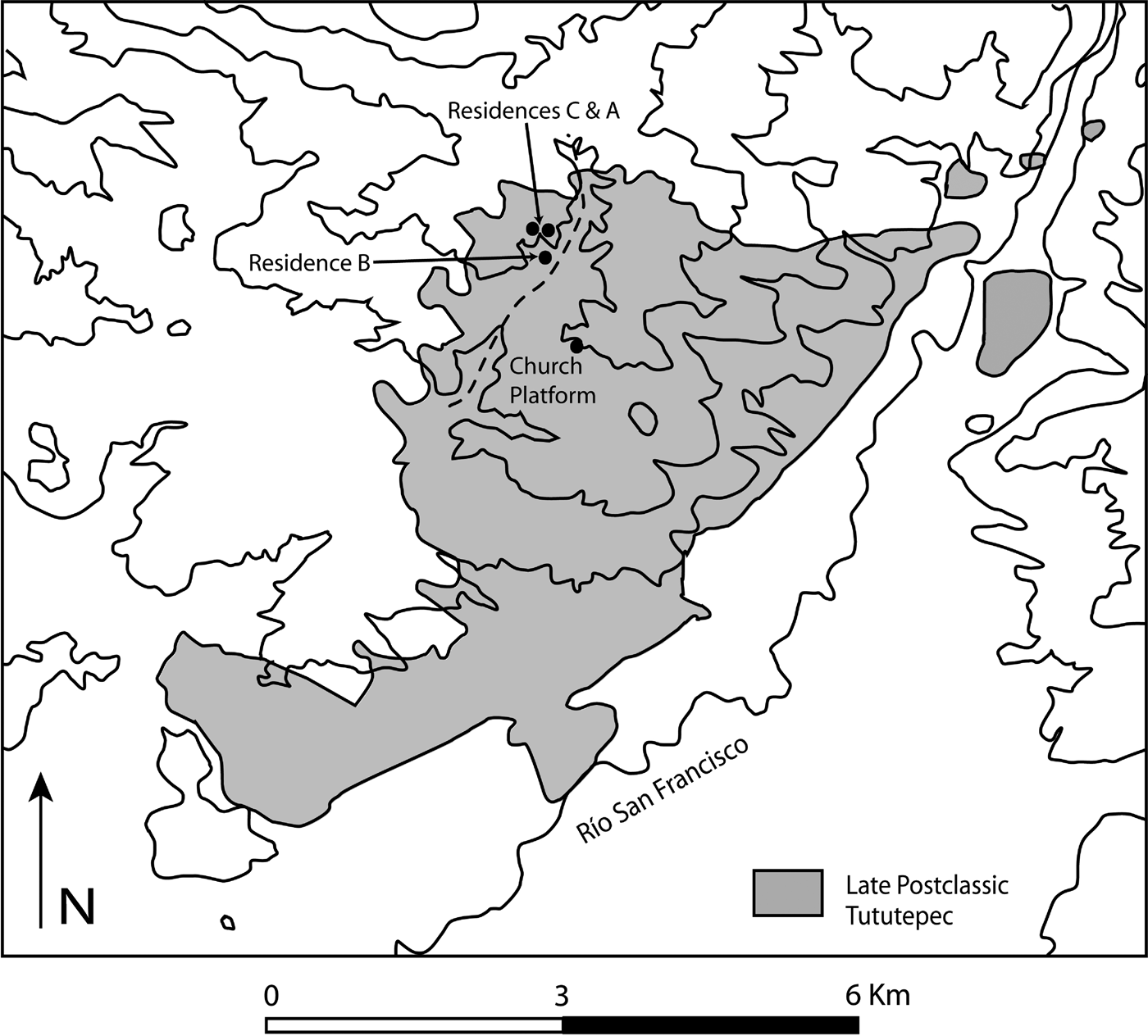
Regional survey data show that during the Late Postclassic Tututepec grew into one of the largest urban centers in southern Mexico with an estimated population exceeding 20,000 (Hedgepeth and Koukopoulos Reference Hedgepeth, Koukopoulos, Barber and Joyce2012; Joyce et al. Reference Joyce, Workinger, Hamann, Kroefges, Oland and King2004). Late Postclassic Tututepec covered 2,185 ha, which represents 94% of the Late Postclassic occupational area in the full-coverage survey zone (Figure 14). Early Colonial indigenous and Spanish documents record that the rulers of Tututepec were some of the most powerful in all of Late Postclassic Mesoamerica (Joyce et al. Reference Joyce, Workinger, Hamann, Kroefges, Oland and King2004; Levine Reference Levine2011:26–29). They controlled an empire that is estimated to have extended from the modern Oaxaca-Guerrero border east to Huamelula, south to the Pacific Ocean, and north approximately 80 km to towns such as Zacatepec, Juchatengo, and Suchixtepec (Figure 15). Tututepec was feared as a military power even beyond its subjugated areas, having attacked towns as distant as Achiutla (125 km to the north) and Tehuantepec (250 km to the east). Although Tututepec often had a tense relationship with Tenochtitlan, it was never conquered by the Aztecs. Tribute paid by subjugated communities to Tututepec included both staples such as corn as well as social valuables including gold dust, feathers, and cochineal. One of the most important sources of tribute for Tututepec's rulers were fungible goods used as forms of currency during the Late Postclassic including cacao, copper axe monies, and cotton mantas (Levine Reference Levine2007, Reference Levine2011).
Map of Late Postclassic Tututepec showing the location of Barrio la Poza and the Church Platform (after Joyce et al. Reference Joyce, Workinger, Hamann, Kroefges, Oland and King2004:Figure 2).
Map of the Tututepec empire (after Spores Reference Spores1993:Figure 1).
In addition to goods obtained from conquered provinces, Tututepec's rulers owned valuable local resources (Levine Reference Levine2007, Reference Levine2011). Early Colonial sources record that Ixtac Quiautzin, the second Colonial period ruler of Tututepec, claimed ownership of 15 fish ponds, 10 saltworks, and 52 cacao orchards in addition to gold, turquoise, pearls, greenstone, quetzal feathers, and other goods (Berlin Reference Berlin1947:31–32; Fernández de Recas Reference Fernández de Recas1961; Woensdregt Reference Woensdregt1996:40). Ethnohistoric records show that Mixtec elites owned large tracts of the best agricultural land that were worked by commoners to pay off tax obligations and by indentured serfs. The land holdings of Tututepec's rulers almost certainly were used to grow cotton for personal use and for trade.
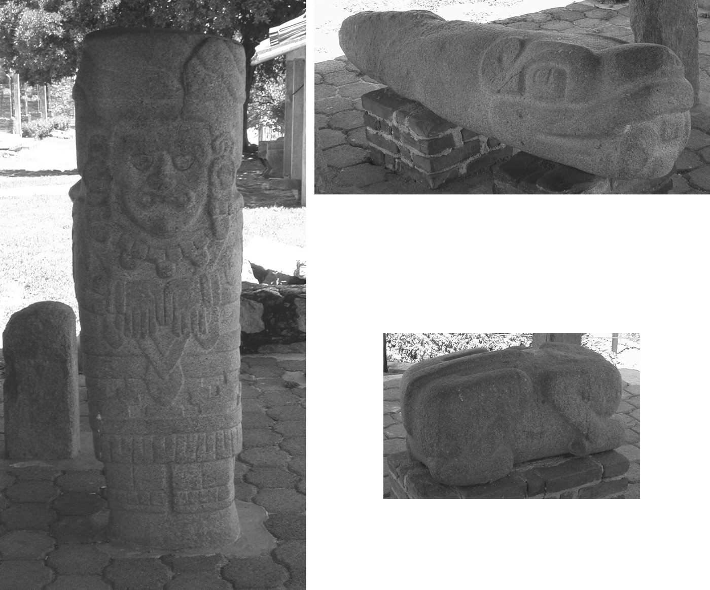
Finally, archaeological research has provided a glimpse into the setting in which the rulers of Tututepec likely lived. The civic-ceremonial core of the site was the large platform on which the colonial church is located (Joyce et al. Reference Joyce, Workinger, Hamann, Kroefges, Oland and King2004:289–290). The platform covers almost 3 ha and reaches an elevation of 10 m. Oral histories suggest that the Church Platform supported the Late Postclassic and Early Colonial period ruler's palace and perhaps the site's Temple of Heaven depicted in the codices (Tibón Reference Tibón1961:72). This claim is supported by the presence of four stone discs originally from friezes that are now placed into the walls of the church (Figure 16). The “disc frieze” is an architectural element shown on palaces and temples in the codices. Located until recently on the southeastern end of the Church Platform, and now moved to the community museum, is a group of eight carved stones that include monoliths, zoomorphic tenoned heads, and a feline sculpture (Figure 17). If the Church Platform was the original location of most of these monuments, then the buildings on the platform would have been some of the most architecturally elaborate in Late Postclassic Oaxaca.
Discs from friezes set into the walls of the Colonial period church at Tututepec (after Joyce and Forde Reference Joyce and Forde2014:Figure 63).
Late Postclassic carved stone monuments at Tututepec (after Joyce and Forde Reference Joyce and Forde2014:Figures 64 and 65; Levine Reference Levine2007:Figure 7.08).
If the people of the lower Río Verde region were largely helpless in the face of powerful elites as assumed by much of traditional archaeological theorizing, then given the military and economic prowess of Tututepec's rulers, it would be difficult to imagine that they had any role in the negotiation of political relations. Yet recent archaeological data from Tututepec indicate that commoners were able to negotiate political and economic relations with elites through everyday domestic practices including cotton production and market exchange (Levine Reference Levine2007, Reference Levine2011).
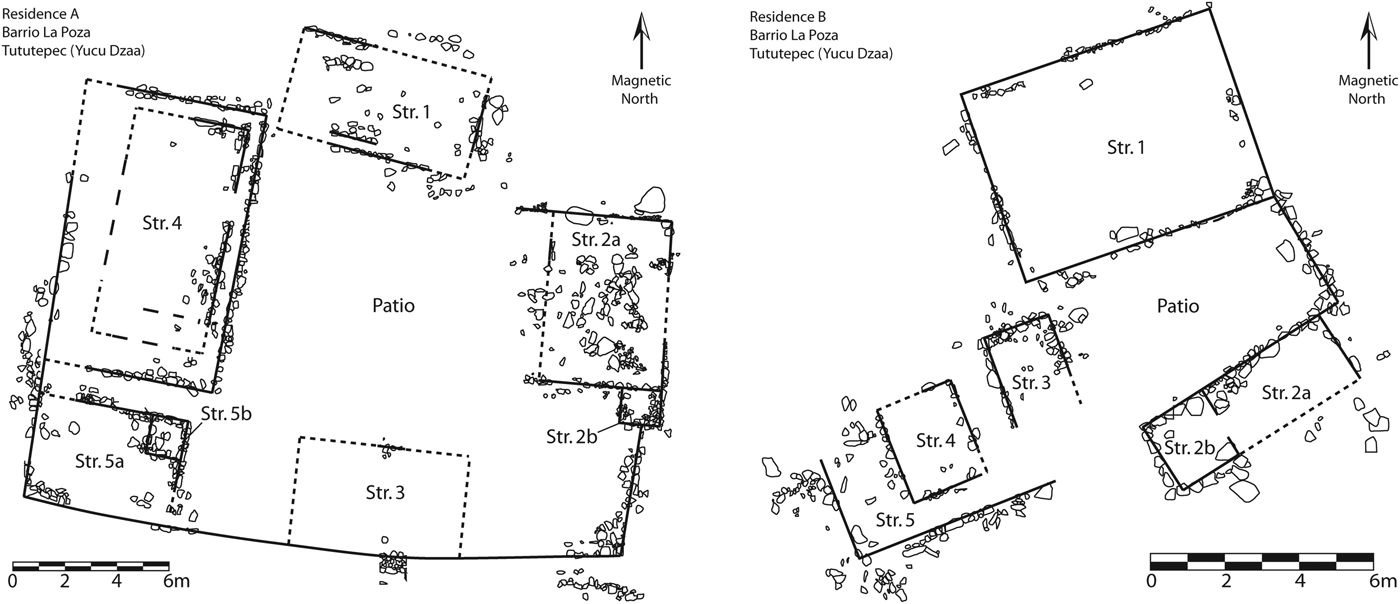
Household excavations at Tututepec examined patterns of production, consumption, and exchange to investigate commoner participation in the political economy (Levine Reference Levine2007, Reference Levine2011; Levine et al. Reference Levine, Joyce and Glascock2011). These excavations focused on three households built on separate terraces in the northern part of the site, approximately 1.25 km north of the Church Platform in an area known as Barrio la Poza. In this area, the remains of at least a dozen households built on terraces were discovered. Extensive horizontal excavations were carried out in two households designated Residences A and B, respectively, and a third one was tested (Residence C). The excavations in Residence A cleared a total of 322 m2, while those in Residence B exposed 230 m2; only 15 m2 were excavated in Residence C.
Both Residences A and B consisted of several rooms with stone foundations surrounding a patio (Figure 18). The upper walls of the residences were probably made of wattle-and-daub like the Early Postclassic houses at Río Viejo. The relatively modest scale and architectural elaboration of the buildings coupled with the recovery of few examples of prestige goods that were symbols of elite status indicate that all three residences were commoner households. Most of the materials recovered from the residences were from middens and included pottery, figurines, spindle whorls, lithics, fire-cracked rock, animal bone, carbonized plant remains, architectural debris, and copper artifacts. Radiocarbon dates indicate that Residence A was occupied in the fourteenth century, while Residence B dated to the fifteenth century. Radiocarbon dates have not been obtained for Residence C, although based on associated ceramics the household dates to the Late Postclassic period. Comparative analyses of architectural features and artifact assemblages indicate that the inhabitants of Residence A enjoyed somewhat greater wealth than those in Residence B.
Plan of Residence A and Residence B at Tututepec (after Levine Reference Levine2006:Figures 4 and 7).
Evidence for domestic production, consumption, and exchange shows that Tututepec's residents were far from economically marginalized (Levine Reference Levine2007, Reference Levine2011). Instead, they were relatively affluent and were active participants in long-distance trade and market exchange.
Data from the household excavations show that the scale of cotton textile production increased relative to Early Postclassic Río Viejo (Levine Reference Levine2007, Reference Levine2011). Artifacts associated with textile production recovered at Tututepec include large numbers of spindle whorls (Figure 12) as well as two roller stamps and two bone awls. Survey data show that textile production was widespread in Late Postclassic Tututepec (Joyce et al. Reference Joyce, Workinger, Hamann, Kroefges, Oland and King2004). The size and weight of the spindle whorls are consistent with those used to spin cotton (Heijting Reference Heijting2006). Spindle whorl frequencies from the excavated households were some of the highest ever reported in Mesoamerica and far exceeded those from Río Viejo (Table 2). Residence A yielded a frequency of 12.5 whorls/1,000 ceramic rim sherds, while Residence B had a frequency of 23 whorls/1,000 rim sherds. Residence C yielded a figure of 25 whorls/1,000 rim sherds. Coupled with the evidence from Río Viejo, these data indicate that textile production increased through the Postclassic and are consistent with data elsewhere in Mesoamerica (Brumfiel Reference Brumfiel, Gero and Conkey1991). Although cotton thread was used for household consumption and to fulfill tax obligations, given the high whorl frequencies, it is almost certain that surpluses of cotton thread were produced and traded for a variety of goods. Late Postclassic thread production represents a practice that took advantage of established institutions and conventions of exchange and provided commoners with a valuable resource that could be deployed in negotiating favorable relations with the political elites of Tututepec.
A variety of artifacts recovered in the houses were obtained via local and long-distance trade, probably in exchange for cotton (Levine Reference Levine2007, Reference Levine2011; Levine et al. Reference Levine, Joyce and Glascock2011). Items that residents of the Tututepec houses acquired included local products like pottery, ceramic figurines and whistles, and fine-grained basalt groundstone tools. Obsidian tools, copper bells and axes, vesicular basalt manos and metates, greenstone beads, and a slate whistle were imported through long-distance trade. Chert tools may have been obtained locally from river cobbles or from sources in the Oaxacan highlands. Like Early Postclassic Río Viejo, obsidian was imported in high frequencies compared to other regions of Oaxaca (Levine Reference Levine2011:32–33). Unlike the Early Postclassic when obsidian from a variety of sources was imported, 97% of Late Postclassic obsidian came from only two sources: Pico de Orizaba and Pachuca. The high frequency of Pachuca obsidian indicates exchange with Aztec pochteca merchants who likely sought cotton cloth, cacao, and other coastal products in exchange. We suspect that the focus on obsidian from Pachuca and Pico de Orizaba resulted from their high-quality material and the long-standing and still desirable economic ties with powerful highland cities like Cholula that controlled these sources (Levine et al. Reference Levine, Joyce and Glascock2011:128–129).
The most highly valued item that was manufactured locally was probably Mixteca-Puebla style polychrome pottery (Forde Reference Forde2006; Levine Reference Levine2007). Mixteca-Puebla polychromes were elaborately painted, with some examples exhibiting images reminiscent of the codices (Figure 19), and used principally in the context of feasting and other domestic rituals (Forde Reference Forde2006). Petrographic and INAA analyses show that the polychromes recovered from the households at Tututepec were characterized by at least four distinct paste recipes derived from local or nearby areas (Cecil and Glascock Reference Cecil, Glascock and Levine2007; Fargher Reference Fargher and Levine2007). Survey data show that the polychromes were broadly available at Tututepec (Joyce et al. Reference Joyce, Workinger, Hamann, Kroefges, Oland and King2004).
Photograph of Mixteca-Puebla style polychrome from Tututepec (Levine Reference Levine2006:Figure 10).
Although the data are limited, ethnohistoric sources focusing on the Mixteca Alta indicate that elites largely controlled long-distance trade (Levine Reference Levine2011; Pohl Reference Pohl, Smith and Berdan2003; Spores Reference Spores1974a:300; Terraciano Reference Terraciano2001:245). Yet frequencies of obsidian and copper artifacts, as well as polychromes in the Tututepec households, far exceeded what has been found in excavated non-royal houses in the Oaxacan highlands (Lind Reference Lind1987; Pérez Rodríguez Reference Pérez Rodríguez2003, Reference Pérez Rodríguez2006; Spores Reference Spores1974b; Spores and Robles García Reference Spores and García2007). These data indicate that Tututepec's commoners had greater access to social valuables and were relatively affluent compared to their highland peers (Levine Reference Levine2011). Instead of economically marginalized due to onerous tax burdens, commoners at Tututepec were active in long-distance exchange, acquiring a variety of valuables. Given the quantity and variety of materials imported by the residents of Tututepec, Levine (Reference Levine2011:34–35) argues that a central market was almost certainly present within the city. Surplus cotton was probably brought to the market and exchanged for products like polychrome pottery, obsidian, ceramic figurines and copper axes.
The evidence from Tututepec indicates that non elites were active participants in the negotiation of political relations through everyday practices including market exchange, domestic ritual, and military participation. The data show that Tututepec's rulers had a variety of means through which revenues were generated including taxing of local people, tribute mobilized from subjugated communities, sponsoring the production of social valuables, extracting wealth from royal land holdings and resources, participating in trade and perhaps intervening in market exchange (Levine Reference Levine2007, Reference Levine2011). Rather than being powerless subjects, however, commoners had a measure of economic autonomy and wealth. Commoners were successful in negotiating tax obligations with rulers such that they were able to retain control over significant surpluses of cotton thread and probably raw cotton. Surplus cotton was traded, most likely in markets, for valuable goods like polychrome pottery, obsidian, and copper items. Since nobles likely controlled long-distance trade, it is probable that Tututepec's central market was a setting where elites and commoners actively negotiated the value and meaning of trade goods and participated in broader discussions regarding status, identity, and power.
Although there were undoubtedly a variety of responses to elite domination, evidence suggests that many people made the active choice to cooperate and participate with Tututepec's rulers (Forde Reference Forde2006; Levine Reference Levine2007, Reference Levine2011). Forde's (Reference Forde2006) study of the iconography on polychrome pottery shows that they communicated popular notions of ideology and corporate identity, especially involving themes of warfare, sacrifice, and the sacred covenant most clearly manifest in eagle imagery. Forde (Reference Forde2006:160–161) argues that polychromes were a material medium through which commoners negotiated power in relation to the exclusionary ideologies of the nobility. Nobles had to frame dominant ideologies so that they had widespread appeal, whereas commoners were able to appropriate aspects of Tututepec's prestige in establishing popular identities. Martial and sacrificial themes depicted on polychromes were congruent with the official ideology of Tututepec and suggest that at least to some extent commoners supported the polity's program of imperial expansion. People may have been willing to participate as warriors because imperial campaigns secured greater tribute payments for Tututepec's rulers, while lowering their own tax burdens. The material rewards would have been even greater if military participation was a route to social mobility, fame, and wealth for those not born into the noble class, such as occurred in the Aztec empire (Clendinnen Reference Clendinnen1991). Another likely motivation for military participation is that warfare and sacrifice in Mesoamerica were embedded in systems of religious belief (Conrad and Demarest Reference Conrad and Demarest1984; Headrick Reference Headrick, Brown and Stanton2003; Joyce Reference Joyce, Scherer and Verano2014; Orr and Koontz Reference Orr and Koontz2009). Polychrome pottery was used in household rituals where identities, statuses, and social relationships were negotiated. While Tututepec's rulers almost certainly did not participate in ceremonies carried out in the Barrio la Poza households, they undoubtedly were aware of these practices such that domestic ritual figured into broader social negotiations. The wealth of commoners such as those that lived in Barrio la Poza, relative to people in other parts of Postclassic Oaxaca, suggest that through the negotiation of political relations with elites, commoners came to benefit from the overall political and economic power of Tututepec.
CONCLUSIONS
Evidence supports the argument that the farmers, cooks, crafters, and traders of the lower Río Verde Valley contributed to the negotiation and transformation of political relations in the region. Political change was not simply the result of the decisions, dispositions, and interests of powerful elites, but was part of a social process that engaged all people in the region. While the actions of lower Verde elites are emphasized in the imagery of the carved stones at Río Viejo and in the Mixtec codices, the archaeological record of everyday domestic life, including how those monuments were reused and reinterpreted by common people, shows that we cannot fully understand social and political change without considering all people as social actors. Likewise, we cannot forget that the places of power—monumental buildings and public spaces—do not simply disappear after they are abandoned by rulers and the nobility to fall into ruin or become occupied by “squatters” (Bradley Reference Bradley1993; Joyce Reference Joyce, Bowser and Zedeño2009). The afterlife of monuments involves practices that can reconfigure identity and power, as in the occupation of Río Viejo's acropolis during the Early Postclassic period, the dismantling of buildings, and the appropriation and transformation of important ceremonies involving death, sacrifice and the sacred covenant.
The data from the lower Verde show that everyday domestic practices like spinning cotton and market exchange were not simply mundane tasks, but were means through which people asserted their interests and identities and negotiated social and political relations with other members of society, including rulers (also see Blanton Reference Blanton, Hirth and Pillsbury2013). In Early Postclassic Río Viejo, the collapse of ruling institutions freed non elites from tax burdens and gave them greater flexibility in establishing exchange relations through which obsidian and other non local goods were acquired. Similar transformations likely occurred in other regions, including the Oaxacan highlands, where ruling institutions and social hierarchies seem to have disappeared for a time during the Early Postclassic period (Faulseit Reference Faulseit2012; Kowalewski et al. Reference Kowalewski, Balkansky, Walsh, Pluckhahn, Chamblee, Rodríguez, Espinoza and Smith2009:345; Markens Reference Markens, García and Guzmán2011; Markens et al. Reference Markens, Winter, Martínez López and Blomster2008). The opening up of long-distance exchange to the broader populace may have contributed to the increasing commercialization of Postclassic economies throughout Mesoamerica as first recognized by Rathje (Reference Rathje, Sabloff and Lamberg-Karlovsky1975; see also Smith and Berdan Reference Smith and Berdan2003).
Everyday practice was also undoubtedly important in the working out of political relations on the local level at Río Viejo. For example, although both the Operation A and B residences were very similar architecturally and in terms of associated material remains, the former had a few unusual artifacts that were not present in the latter, including at least two alabaster bowls, two jade beads, and a turquoise pendant. These artifacts suggest that the residents of Operation A were able to acquire somewhat greater wealth than other residents of Río Viejo. Since the frequency of spindle whorls in Operation A was higher, it is possible that as in the Late Postclassic period, people were able to convert greater surpluses of cotton into somewhat greater wealth. The other finding that distinguishes between the Early Postclassic residences is the unusual interment in the patio of Operation A. If this interment was indeed related to the large-scale ceremonies that occurred on the acropolis during the Late Classic period, as we have suggested, then residents of Operation A may have had specialized religious knowledge and abilities that provided leverage in the negotiation of favorable economic transactions.
The reconfiguration of economic relations in the Early Postclassic period set the stage for the negotiation of political and economic relations at Late Postclassic Tututepec. The specific historical relationships between the people who lived at Río Viejo and those that lived in Barrio la Poza at Tututepec are difficult to disentangle given the migration of Mixtecs into the region. It is likely that Chatinos were incorporated into the Tututepec polity and lived within the city as they did at the time of the conquest and do today (Spores Reference Spores1993:169). It is also likely that the people of Tututepec came to adopt the economic expectations and practices that had developed in the Early Postclassic, especially since similar changes may have occurred in the Oaxacan highlands. Following the reestablishment of dynastic rule by Lord 8 Deer and his successors, it is unlikely that people would have easily agreed to give up the greater economic opportunities and access to resources that they had acquired during the Early Postclassic period. By the Late Postclassic period, the ability to convert surpluses of cotton into social valuables involved institutionalized practices and assumptions that would have been a starting point for the negotiation of social relations with the new Mixtec ruling elite. Commoners controlled production of large quantities of cotton, which gave them leverage in negotiations with rulers. Elites, in turn, could not ignore the interests of commoners since the latter provided the labor to cultivate, process, and spin cotton, which was a key resource in the regional political economy as well as in relations with elites in distant regions.
The long-term structural effects of ongoing social negotiations embedded in everyday practices like marketing, participating in public and domestic rituals, paying taxes, trading with merchants, collecting tribute from provinces, and providing military service created a synergy between the interests of Tututepec's populace and its rulers. Tribute acquired from imperial provinces reduced tax burdens for Tututepec's residents, which left people with significant cotton surpluses that could be exchanged in the city's central market for staples such as utilitarian pottery, local valuables like polychrome ceramics, and goods obtained through long-distance trade such as obsidian and copper. Elites also controlled long-distance exchange in valuable commodities sought by commoners. Through the negotiation of these political-economic relations many commoners came to have a vested interest in the polity, which was reflected in military service and in the iconography of the polychrome vessels that they obtained at market. The participation of many people—farmers, crafters, and consumers, as well as rulers, merchants, and imperial administrators—therefore contributed to the long-term political success of the Tututepec empire. Without an understanding of the complex, ongoing negotiations among the diverse individuals and collectivities that constituted Postclassic society in the lower Río Verde Valley, our understanding of its political history would be insufficient.
RESUMEN
En este artículo, examinamos la importancia de las prácticas domésticas en las transformaciones sociales y políticas del periodo posclásico (800–1522 d.C.) en el valle del Río Verde bajo en la costa pacífica de Oaxaca, México. Planteamos que después del colapso de las instituciones políticas y de las dinastías en el poder, la gente común obtuvo mayor autonomía económica y política. Las excavaciones en unidades domésticas en Río Viejo junto con los datos del recorrido regional indican que durante el posclásico temprano (800–1100 d.C.) la gente común aprovechó la ausencia de la autoridad regional para tomar mayor control sobre los excesos de producción de bienes, en especial el hilo de algodón, así como el acceso a objetos de valor social y redes de intercambio a larga distancia. La gente también pudo haber tomado responsabilidades rituales que anteriormente estaban reservadas únicamente para la nobleza. Estas prácticas económicas y rituales formaron parte del ámbito social diario dentro del cual nuevas dinastías surgieron. Para el inicio del posclásico tardío (1100–1521 d.C.), el Río Verde bajo estaba nuevamente dominado por líderes poderosos centrados en la ciudad de Tututepec. Sin embargo, muchas de las excavaciones muestran que la gente común en el posclásico tardío seguía controlando el excedente de bienes de producción y tenía acceso a objetos de valor social tal como el cobre y la cerámica policroma a través de un mercado de intercambio. Argumentamos que las relaciones políticas durante el posclásico tardío eran el resultado de negociaciones entre la élite y la gente común. Éstas estaban influidas por el contexto sociopolítico del posclásico temprano, donde la gente que no pertenecía a la élite demostraba mayor autonomía económica y, por lo tanto, mayor poder político en comparación al periodo clásico tardío (500–800 d.C.). A través de la negociación de estas relaciones político-económicas, durante el posclásico tardío mucha de la gente común se vio involucrada de alguna manera en la unidad política de Tututepec, lo cual se puede observar en el servicio militar y en la iconografía de las vasijas polícromas que compraban en el mercado. La participación de muchas personas (campesinos, artesanos, y consumidores, así como dirigentes, mercaderes y administradores imperiales) contribuyó al éxito a largo plazo del imperio de Tututepec. Si no se tomaran en cuenta las negociaciones complejas y en desarrollo continúo entre los diversos individuos y los grupos que componían la sociedad posclásica del valle del Río Verde bajo, nuestro entendimiento de su historia política estarían incompleto.
ACKNOWLEDGMENTS
We would like to thank Cynthia Robin and Scott Hutson for inviting us to participate in this special section of Ancient Mesoamerica. We thank the Consejo de Arqueología and the Centro INAH Oaxaca of the Mexican Instituto Nacional de Antropología e Historia. We also thank the people of the lower Río Verde Valley for their friendship and assistance through the years. Funding for the research discussed in this article has been generously provided by grants from the following organizations: Joyce (National Science Foundation [NSF] grants [1987]:BCS-8716332, [1996]:BCS-0096012, [2011]:BCS-1123388; National Geographic Society Grant [1988]:3767-88; Wenner-Gren Foundation Grant [1988]:4988; Fulbright-García Robles Fellowship; H. John Heinz III Charitable Trust; University of Colorado CARTSS, CRCW, Dean's Small Grant, Norton Fund; Vanderbilt University Research Council, Mellon Fund. Joyce and King (Foundation for the Advancement of Mesoamerican Studies (FAMSI) Grant [1999]:99012). Levine (NSF [2005]:BCS-0508078; Fulbright-García Robles Fellowship; FAMSI Grant [2005]:05031; University of Colorado Graduate School, Department of Anthropology). King (NSF [2001]:BCS-0122226; University of California, Berkeley, Stahl Endowment of the Archaeological Research Facility, Lowie-Olson Fund of the Department of Anthropology; Indiana University Summer Faculty Fellowship). Hedgepeth (University of Colorado Sigma Xi Grant-in-Aid of Research, Anthropology Graduate Student Research Award, Beverly Sears Graduate Student Grant, CU Museum of Natural History Walker Van Riper Grant; Alice Hamilton Scholarship from the Colorado Archaeological Society). Barber (NSF [2011]:BCS-1123377; University of Central Florida Office of Research and Commercialization, Department of Anthropology). We also thank Doug Bamforth, Cathy Cameron, Beth Dusinberre, Gerardo Gutiérrez, Scott Hutson, Michele Koons, Steve Lekson, Cira Martínez López, Payson Sheets, Paola Villa, Marcus Winter, Mike Smith, and an anonymous reviewer for suggestions on the paper and for intellectual input during the research reported here.
Data Availability Statement: All field reports for research discussed in this article are publically available from the Archivo Técnico of the Coordinación Nacional de Arqueología, Instituto Nacional de Antropología e Historia, Mexico City.