Introduction
Geoarchaeological studies have shown the relevance of a comprehensive approach to understanding settlement patterns of ancient humans (Waters, Reference Waters1992). This scientific technique involves the study of the history of landscape formation and geological processes that bury cultural remains (Butzer, Reference Butzer1982; Kuzmin, Reference Kuzmin2017). Studies include analysis and documentation of Quaternary deposits, geomorphological mapping, research of paleoecological indicators, and geochronological dating. Archaeological research in the Baikal-Patom Highlands, carried out continuously for 40 years, provides data to form a primary understanding of the Vitim valley development in the area of the richest concentration of archaeological sites, the Mamakan Geoarchaeological Area (Belousov et al., Reference Belousov, Ineshin, Sulerzhitsky and Tetenkin2002; Ineshin and Tetenkin, Reference Ineshin and Tetenkin1996; Ineshin and Teten’kin, Reference Ineshin and Tetenkin2017; Fig. 1). Within this area, the study of the Late Paleolithic–Neolithic culture at the Kovrizhka I–VI sites (Tetenkin, Reference Tetenkin2022b, Reference Tetenkin2025) aroused the greatest interest. The Kovrizhka sites are some of the most studied and highly informative for the entire region of the northern Cis-Baikal Siberia and illustrate the history and development of the ancient culture in the Vitim area during the Late Upper Paleolithic (LUP)–Early Neolithic (EN) spanning the period from the last glacial maximum (LGM) to the Middle Holocene. Many aspects of Paleolithic culture found at Kovrizhka (including art, housing, signs and symbols, microblade technology, and ceramics) are of significance on a large scale in northeast Asia (Pitulko and Pavlova, Reference Pitulko and Pavlova2010; Gómez Coutouly, Reference Gómez Coutouly2018; Mao et al., Reference Mao, Zhang, Qiao, Liu, Chang, Xie and Zhang2021; Markin and Shunkov, Reference Markin, Shunkov and Shunkov2022), representing the ancient hunter-gatherer culture of the vast subcontinent. At the Kovrizhka sites, archaeological materials were found in a multi-layered position in three alluvial terraces: on the beach, in floodplain deposits, and on the slope of the valley 250 m from the river and 33 m above river level. A priori, an important factor in the settlement of the inhabitants was the choice of a safe and convenient place for settling, which is strongly reflected in the vertical distribution of cultural horizons. At the same time, the water regime of Vitim River—the main drainage of the Baikal-Patom Highlands, the Stanovoy Ridge, and the Vitim Plateau (Zolotarev, Reference Zolotarev1974a)—played a key role.
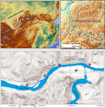
Overview of the study area within the Baikal-Patom Highlands (A and B) and Mamakan Geoarchaeological Area in the valley of Vitim River (C). Archaeological sites on (B) and (C): 1, Pavlova; 2, Kovrizhka I–VI; 3, Bol’shoi Yakor’ I; 4, Mamakan VI; 5, Invalidny III; 6, Bol’shaya Severnaya; 7, Niryakan; 8, Avdeikha; 9, Sinya; 10, Kakolda; 11, Pronikha; 12, Sinyuga; 13, Butuya; 14, Nerpo; 15, Signai.

Figure 1 Long description
A) A topographic map of the Central Siberian Plateau, highlighting the Baikal-Patom Highlands. The map includes elevation contours and geographic coordinates. B) A detailed map of the Baikal-Patom Highlands, showing the Vitim River and surrounding terrain. The map includes a scale bar of 100 km and geographic coordinates. C) A close-up map of the Vitim River area, displaying contour lines and elevation markers. Stars indicate archaeological sites along the river, with specific coordinates and elevations noted. The map includes a scale bar of 2 km and geographic coordinates. The stars are distributed along the river, indicating the locations of archaeological interest.
General ideas of the Quaternary morphological evolution of the Vitim valley were proposed in the second half of the twentieth century (Mirchink, Reference Mirchink1960; Kazakevich, Reference Kazakevich1972; Zolotarev, Reference Zolotarev1974b). Based on geological and geomorphological studies, a series of five to six terraces were mapped. However, detailed recent research (Margold et al., Reference Margold, Jansson, Stroeven and Jansen2011) points to the more complex nature of its history. The primary factors that influenced the development of the Vitim valley were periodic megafloods that arose in the Late Pleistocene at the breakthrough of the glacially dammed Lake Vitim in the Muya Basin (Margold et al., Reference Margold, Jansen, Codilean, Preusser, Gurinov, Fujioka and Fink2018). Several stages of megafloods have been reconstructed, including the last one, dated 21.8 ± 1.5 to 14.9 ± 2.0 ka, that is, the time of the first episode of settlement at the Kovrizhka geoarchaeological site.
Thus, the contradictory and uncertain morphological evolution of the lower Vitim valley at the end of the Pleistocene and the Early Holocene determined the need to analyze archaeological and geochronological data at the Kovrizhka sites to reconstruct the Late Pleistocene–Holocene geomorphology of the Vitim valley in the context of megafloods and periodic floods and better understand the settlement history and ancient people’s life in the Vitim valley from 19.9 to 6 ka.
Geographic and geological setting
Study area
The Baikal-Patom Highlands, part of the Baikal Mountain Region, are located north of the Stanovoy Ridge, to the east and southeast of the Central Siberian Plateau and west of the Olyokma-Chara Highlands (Zolotarev, Reference Zolotarev1974a). They extend in the northeastern direction and have a length of about 700 km and maximum width (in the northeast) of 330 km. The highest elevation is 2578 m above sea level in the southwest at Inyaptuk Peak. The uplands boundary is clearly defined by large erosion–tectonic valleys. The stepped slopes of the uplands are intensively eroded in some places, separating them from the Olyokma-Chara Highlands and the Siberian Plateau. The border with the Stanovoy Ridge is represented by the northwestern slopes of the ridges of Stanovoy Ridge (Kodar, Verhneangarsky, and Kichersky) towering over the adjacent sections of the Baikal-Patom Highlands at 150–200 m and the erosion–tectonic fragments of river valleys.
The main drainage system is the Vitim River and its tributaries. The Vitim River conventionally separates the Baikal-Patom Highlands into the Patom and Baikal parts. The study area includes the lower part of the Vitim valley. The average long-term water flow near Bodaybo city is 1521 m3/s. A vertical pattern in vegetation is well expressed from mountain tundra in the mountain ranges above 2100 m to larch (Larix) forests with cedar (Cedrus) and spruce (Picea) in mid-elevations, and wild rosemary (Rosmarínus officinalis), blueberry (Vaccínium myrtillus), and lingonberry (Vaccínium vitis-idaea) in the mountain taiga belt and along the bottoms of the valleys (Atlas of Irkutsk region, 1962).
Classic representation of terrace formation in the Vitim River valley and tributaries
The Late Pleistocene glaciation of the Baikal-Patom Highlands is one of the most important stages in the formation of the mountain landscape. Under these conditions, large glacier-dammed lakes and associated megafloods arose, developed, and degraded. The sources for paleogeographic reconstructions are glacial, erosion-accumulative topography and deposits, which are rich in faunal and anthracological materials.
In the Late Pleistocene, the Vitim valley was buried by alluvium of different thickness from the periodic discharge of the glacially dammed Lake Vitim (Margold et al., Reference Margold, Jansen, Codilean, Preusser, Gurinov, Fujioka and Fink2018), followed by erosional incisions and the formation of a series of terraces. For this reason, it is difficult to compare the terraces within both the Vitim valley and its neighboring river systems.
Endrikhinsky (Reference Endrikhinsky and Logachev1982) studied the middle part of the Vitim valley and documented a floodplain at 3–4 m and terraces at 8–10 m (T1) and 18–22 m (T2). According to other researchers (Zolotarev, Reference Zolotarev1974b; Tishchenko, Reference Tishchenko and Logachev1982), a large incision occurred after the Marine Isotope Stage (MIS) 4 glaciation, resulting in the formation of 30–40, 18–25, and 7–12 m terraces. There are sometimes deviations in the number and height of terraces depending on the position of the section in the valley and its remoteness from the local basis of erosion. The farther upriver the studied area is located, the lower the height and number of terraces (this is also relevant for the lateral tributaries of the Vitim River). The third and second terraces formed in MIS 3, the first in MIS 2 (Zolotarev, Reference Zolotarev1974a, Reference Zolotarev1974b).
According to Tishchenko (Reference Tishchenko and Logachev1982), the 15–25 m terrace of the Bodaibo River and the 50 m terrace of the Vitim River were formed in MIS 2. The accumulation of sediments at this time took place in a cold and humid climate with a clear trend of significant runoff during floods, which contributed to the accumulation of sediments on the high floodplain. This led to the formation of a 25 m terrace in the lower part of the Bodaibo River, which declines to 15 m in the middle section of the river. Its deposits are characterized by an increased thickness of the floodplain alluvium consisting mainly of fine-grained polymict light gray sands. In the middle stream of the Bodaibo River, the thickness of the flood silts decreases. In the Vitim valley, this terrace is represented downstream of Bodaibo city by surviving fragments almost 50 m above the waterfront (Tishchenko, Reference Tishchenko and Logachev1982). The floodplain alluvium is also represented by fine-grained polymict sand, and the channel alluvium is sandy–pebble–rock. On the surface of the gravel, there is a carbonate crust. It was also noted that the different heights of the same-age terraces can be explained by the prevalence of deep or lateral erosion, distance from the local basis of erosion, deformation by “young” tectonic processes, and association with different geomorphological regions (Endrikhinsky, Reference Endrikhinsky and Logachev1982).
The spore–pollen spectra of the first terrace of Vitim River, near the mouth of the Tamarak River (Fig. 1), contains dwarf birch (Betula nanae), Siberian selaginella (Selaginella sibirica), and burr selaginella (Lycopodium pungens) typical of periglacial vegetation (Kazakevich and Reverdatto, Reference Kazakevich and Reverdatto1972). The time of formation of these deposits is attributed to the Sartan glaciation (MIS 2) (Grichuk and Grichuk, Reference Grichuk and Grichuk1960; Grichuk and Zaklanskaya, Reference Grichuk and Zaklanskaya1985).
On the Baikal-Patom Highlands in MIS 2, the glaciation was most developed in the high mountains and had a mountain-valley character (Sinyugina, Reference Sinyugina1960; Zolotarev, Reference Zolotarev1974b; Kazakevich and Reverdatto, Reference Kazakevich and Reverdatto1972; Tishchenko, Reference Tishchenko and Logachev1982). It has been suggested that an ice cap more than 700 m thick existed within the Baikal part of the mountain range in the southern highlands (Levi et al., Reference Levi, Mats, Kusner, Kirillov, Alakshin, Tolstov, Osipov, Efimova and Bak1998). The center of glaciation in the northern highlands, was the Kropotkin Ridge (Zolotarev, Reference Zolotarev1974b, Reference Zolotarev1982; Tishchenko, Reference Tishchenko and Logachev1982).
Warming at the transition from the Late Pleistocene to Holocene led to the retreat of the glaciers and formation of end, lateral, and bottom moraines. Several attempts at paleogeographic reconstruction were made based on dating of a series of end moraines located at a considerable distance from each other (Levi et al., Reference Levi, Mats, Kusner, Kirillov, Alakshin, Tolstov, Osipov, Efimova and Bak1998; Ineshin, Reference Ineshin2003).
Early paleogeographic reconstructions based on archaeological data
There are previously published paleogeographic reconstructions of the Vitim valley based on archaeological research. The primary archeological sites used in these reconstructions were Bol’shoi Yakor’ I and Kovrizhka I–VI. These studies identified the stages of landscape formation in the Vitim River valley (Mamakansky site) (Belousov et al., Reference Belousov, Ineshin, Sulerzhitsky and Tetenkin2002; Ineshin and Tetenkin, Reference Tetenkin2017; Demonterova et al., Reference Demonterova, Ivanov, Ineshin and Tetenkin2014; Henry and Tetenkin, Reference Henry and Tetenkin2014; Henry et al., Reference Henry, Bezrukova, Teten’kin and Kuz’min2018).
The main points of this reconstruction are as follows:
1. The Vitim paleochannel was located at an altitude of 50–60 m above the modern level of the river before MIS 4.
2. In MIS 4 and subsequent times, erosional incision of the Vitim River occurs. The Mamakan VI site is located in the upper deposits of the Sartan age (MIS 2) at a height of 33 m above the Vitim River.
3. In MIS 2, the formation of terraces (22, 18, and 14 m) occurred, on which the Avdeikha, Kovrizhka II–IV, and Bolshoy Yakor I sites are located.
4. In the first half of the Holocene, the formation and lateral erosion of 9–11 m of the terrace occurred, on which archaeological sites Invalidny I–III, Mamakan I–V, Kovrizhka I, V, and Pavlova are located. The height of the terrace increased due to the formation of bars on its surface.
5. The latest erosional incision of the Vitim River and the accumulation of 8–9 m of floodplain occurred in the Middle to second half of the Holocene (Ineshin and Tetenkin, Reference Tetenkin2017).
In the Vitim valley, the earliest stratified cultural remains at Kovrizhka IV (cultural horizon 6) are dated around 19–18 ka BP (Tetenkin et al., Reference Tetenkin, Henry and Klementyev2017). Radiocarbon-dated remains of snow sheep (Ovis nivicola), elk (Alces alces), and shrub willow (Salix) charcoal are interpreted as representing an open tundra landscape with small islands of forest vegetation, represented by a single piece of larch or spruce charcoal (Henry et al., Reference Henry, Bezrukova, Teten’kin and Kuz’min2018). Faunal remains of a horse (Equus sp.) from the Avdeikha site are also interpreted to represent the existence of the forest-free areas (Mochanov, Reference Mochanov1977, table D). Cultural horizon 6 at Kovrizhka IV contains the only remains of a mammoth (Mammuthus primigenius) found in the archaeological complexes of the Vitim valley, consisting of blades of tusk, from which anthropomorphic figures are made (Tetenkin et al., Reference Tetenkin, Zhmur, Demonterova, Kaneva and Salnaia2018b). The synchroneity of these remnants of mammoth to the episode of human habitation cannot be judged in the absence of direct dates of these remains. However, their presence in the layer is an indicator of the availability of material such as mammoth tusk to people occupying the site during this time.
The expanded paleoecological characteristic of the MIS 2 (15–13.5 ka) is provided from research of the Bol’shoi Yakor’ I site (Ineshin and Tetenkin, Reference Tetenkin2017). Here, 28 species of animals have been identified, including representatives of ornitho-, terio-, and ichthyofauna. Snow sheep, reindeer (Rangifer tarandus), horse, musk ox (Ovibos pallantis), arctic fox (Alopex lagopus), tundra partridge (Lagopus muta), gopher (Spermophilus cf. parryi), and marmot (Marmota sp.) remains are present and represent a tundra environment (Ineshin and Tetenkin, Reference Tetenkin2017). Bison (Bison sp.), wolf (Canis lupus), and red deer (Cervus elaphus) remains are indicators of mixed tundra–forest landscapes. The presence of sable (Martes zibellina) and elk remains indicates the existence of forest refugia. The mountain landscape of the Vitim valley determined the vertical zonal distribution of vegetation. With the general domination of the tundra–steppe landscape with shrubs, isolated locations of forest vegetation existed in the Vitim River Valley and its tributaries on the lower topographic levels: slopes, the first terrace, floodplain, and so on.
In the period 13.2–12.2 ka, the anthracological remains of Kovrizhka III cultural horizon 2 suggest vegetation is represented exclusively by larch, a cold-loving species (Henry and Tetenkin, Reference Henry and Tetenkin2014; Henry et al., Reference Henry, Bezrukova, Teten’kin and Kuz’min2018).
The expansion of heat-loving spruce, fir (Abies), and pine (Pinus) was recorded in the Early Holocene deposits of cultural horizon 1A at the Kovrizhka III site (9.2 ka) (Henry et al., Reference Henry, Bezrukova, Teten’kin and Kuz’min2018). Nevertheless, open spaces on the Baikal-Patom Plateau were still preserved, as evidenced by the remains of snow sheep in cultural horizons 4A and 2 at Kovrizhka II (Tetenkin, Reference Tetenkin2010). Based on the results of landscape and climatic reconstruction in the area of the Bols’shoe Inyaptukskoye Lake in the southern part of the Baikal Highlands, changes in vegetation in the inner parts of the Baikal-Patom Highlands were 1.5–2 millennia later when compared with the development of landscapes near the mouth of the river (Bezrukova et al., Reference Bezrukova, Anderson, Vinkovskaya, Kharinsky and Kulagina2012).
New geochronological data and ideas about the formation of the Vitim River Valley for the last 60 ka BP
Margold et al. (Reference Margold, Jansen, Gurinov, Codilean, Fink, Preusser, Reznichenko and Mifsud2016) reconstructed the last glaciation within the Baikal-Patom Highlands and the Kodar and Udokan ridges. The ages of terminal moraines and other glacial forms were obtained based on beryllium (10Be) and optically stimulated luminescence (OSL) dating, and a glaciation map was compiled for MIS 2. The exhibited 10Be age of end moraine of Lake Oron and the Basny River (in the Vitim catchment) indicates the existence of glaciers along the Vitim valley in the area of the Delyun-Oronsky knickpoint at ∼20 ka, during the LGM, and in the tributaries of Vitim River at ∼16 ka (Margold et al., Reference Margold, Jansen, Gurinov, Codilean, Fink, Preusser, Reznichenko and Mifsud2016).
The center of the glaciation was the Kodar and Udokan ridges. The movement of glaciers in the northeastern direction into the Mamakan River valley and part of the Vitim River valley on the section Nerpo–Shakhtol’nya–Amalyk was reconstructed. At the same time, despite the presence of traces of glaciation (e.g., sheepback at the mouth of the Bodaybo River and glacial hatching on boulders), the existence of a glacier in MIS 2 near Bodaybo city and the Mamakan Geoarchaeological Area is debatable (Margold et al., Reference Margold, Jansen, Gurinov, Codilean, Fink, Preusser, Reznichenko and Mifsud2016).
The Late Pleistocene glaciation on the Baikal-Patom Highlands had a significant impact on the paleolandscape situation, including periodically occurring dammed glacial lakes and catastrophic water discharges. According to Margold et al. (Reference Margold, Jansen, Codilean, Preusser, Gurinov, Fujioka and Fink2018), breakthroughs of the glacial-dammed Vitim Lake dated 56 ka, 37–29 ka, and 21.8 ± 1.5 to 14.9 ± 2.0 ka were catastrophic for the Vitim valley. These events eroded the terraces that existed at that time and formed thick layers of megaflood sediments. At present, megaflood deposits are recorded at a height of 100 m or more above the current water level of the Vitim River. Such transformations in the valley influenced the formation of a new complex of terraces. The decline of alluvium thickness downstream of the river influenced the maximum height of the terraces. It should also be noted that this type of sediment was formed in tributaries, for example, in the Bodaibo River valley (Margold et al., Reference Margold, Jansen, Codilean, Preusser, Gurinov, Fujioka and Fink2018). Filling of tributaries with sediments of a catastrophic flow could occur at a distance of tens of kilometers up the valley, gradually decreasing in thickness down the valley. These deposits blocked the mouth of the tributaries and created the conditions for the formation of dammed lakes in which silts and fine sands were deposited.
Methods
Long-term research at the Kovrizhka sites has relied upon a range of methods, including morpho- and techno-typological analysis of artifacts, statistical characteristics of collections, and analysis of the planigraphy of cultural remnants. A number of methods—for example, use-wear, petrographic, paleomagnetic, geochemical, paleontological, and ZooMS analyses—were aimed at solving special archaeological problems, such as determining the composition of artifacts, ochre, exotic substances, species of hunted animals, and heating temperatures of stones in hearths (Tetenkin et al., Reference Tetenkin, Henry and Klementyev2017, Reference Tetenkin, Zhmur, Demonterova, Kaneva and Salnaia2018b, Reference Tetenkin, Demonterova, Kaneva, Henry and Gauvrit Roux2020a; Gauvrit Roux et al., Reference Gauvrit Roux, Teten’kin and Henry2021). Special attention was paid to the stratigraphy of artifact occurrences and identification of markers of postdepositional taphonomic processes such as cryogenesis. The characterization of the landscape and paleoclimate was addressed by applying the methods of anthracology and paleontology (Henry and Tetenkin, Reference Henry and Tetenkin2014; Henry et al., Reference Henry, Bezrukova, Teten’kin and Kuz’min2018; Tetenkin et al., Reference Tetenkin, Henry and Klementyev2017). Our previous studies characterized the culture of the LUP through EN in the lower Vitim River (19–7 ka ago). Particular attention was paid to aspects of housing construction, heating, food supply, stone production, ceramic production, seasonal mobility, exploitation of mineral and plant resources, sign-symbolic activities, and art. Radiocarbon dating plays a special role in the study of the archaeological sites of Kovrizhka I–VI. It was on this basis that it became possible to link in a single chronological sequence the numerous levels of cultural remains from all six locations and thus to begin building a model of landscape formation in this section of the Vitim valley. Early radiocarbon dates were obtained by the oscillatory method. Since 2010, radiocarbon dating has been done using the accelerator mass spectrometry (AMS) method with subsequent date calibration (OxCal 4.4.4; Bronk Ramsey, Reference Bronk Ramsey2009). The main dating material was charcoal due to the poor preservation of bone and other organic materials. Bone dates are few and far between. Furthermore, two of them were obtained from bioapatite in dental enamel, which is considered an unreliable source (Cherkinsky, Reference Cherkinsky2009; Zazzo and Saliège, Reference Zazzo and Saliège2011). Bone dates were obtained from paleontologically indeterminate samples. Therefore, in radiocarbon chronology, we rely on dates obtained from charcoal samples. At Kovrizhka III and IV, some charcoal samples were taken from hearths as well as from the living floor and cultural layers (Table 1). Bone samples were also taken from the living floor near the hearths. With this work, the revision of previously published radiocarbon dating (Tetenkin, Reference Tetenkin2022b) was carried out. Based on these data, a synthetic model of the chronology of landscape development and human occupation of the Vitim River valley was built.
Radiocarbon dates from Kovrizhka I–VI.

Table 1 Long description
Rows list radiocarbon measurements by site and stratigraphic unit, with columns for 14C yr BP, calibrated years BP at 95.4 percent, median calibrated years BP, material, and sample number. Kovrizhka IV includes the oldest entries, with cultural horizon 2G dated 31,200 plus or minus 400 and 31,000 plus or minus 400 14C yr BP, calibrated to 36,315 to 34,701 and 36,174 to 34,610 cal yr BP, with medians 35,599 and 35,391, from charcoal on the living floor. Kovrizhka IV also has multiple dates around 15,750 to 14,290 14C yr BP across cultural horizons 6 through 2B, mostly charcoal from hearths or living floors, plus one tooth bioapatite date at 14,790 plus or minus 35 and another at 14,290 plus or minus 35, and a paleosoil between cultural horizons 1 and 2 dated 11,440 plus or minus 60 and 11,260 plus or minus 60. Later Kovrizhka IV entries include cultural horizon 1 at 8,980 plus or minus 20 and 8,005 plus or minus 35, and one cultural horizon 6 charcoal date at 8,350 plus or minus 120. Kovrizhka III ranges from 11,390 plus or minus 230 in cultural horizon 3 down to 8,095 plus or minus 190 in cultural horizon 1, with charcoal from hearths or living floors and one AMS marked entry at 10,875 plus or minus 40. Kovrizhka II includes cultural horizon 5 at 16,510 plus or minus 90 and 11,190 plus or minus 390, and cultural horizons 4A and 3 at 8,230 plus or minus 100 and 8,180 plus or minus 130, all on charcoal from living floors. Kovrizhka V lists depth based samples at 12,200 plus or minus 60 and 11,400 plus or minus 50, then cultural horizons 3, 2, and 1 and a level under cultural horizon 1 spanning 10,969 plus or minus 50 down to 7,520 plus or minus 140, all charcoal from charcoal, burned wood, or burned wood horizons. Kovrizhka I has cultural horizon 2 at 6,095 plus or minus 135 and 5,945 plus or minus 90, and cultural horizon 1 at 2,800 plus or minus 140, with charcoal from burned wood horizons and a colluvial layer associated with an artifact.
a OxCal v. 4 4.4 (Bronk Ramsey, Reference Bronk Ramsey2009); IntCal20 Northern Hemisphere Radiocarbon Age Calibration Curve (Reimer et al., Reference Reimer, Austin, Bard, Bayliss, Blackwell, Bronk Ramsey and Butzin2020). An asterisk (*) indicates accelerator mass spectrometry (AMS) radiocarbon data.
Analysis of archaeological and geochronological data of the Kovrizhka I–VI sites
The group of archaeological sites Kovrizhka I–VI (N 57.811°, E 113.948°) is located in the center of the Baikal-Patom Highlands (Figs. 1 and 2), in the Vitim River valley (lower current). It is administratively owned by the Bodaybo district, Irkutsk region.
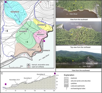
The Kovrizhka sites are located on the west bank of the Vitim River and are expressed in relief by a small extension behind the rock cape, which formed a favorable environment for the temporary residence of ancient humans. The section in Figure 2, about 250 m long, has a stepped profile consisting of a 6-m-high floodplain (HFP), and 9–11 (TI), 17–19 (TII), and 22 m (TIII) terraces. Higher up the slope, colluvial deposits occur on the bedrock. The graded character of the valley slope is complicated by the cross-sectional cuesta ridge relief formed by the selective denudation of monoclinal amphibole gneisses and pegmatites.
Plan (A), perspective photographs of a general view (B), and profile (C) of the geoarchaeological sites Kovrizhka I–VI. The photographs (B) show the Kovrizhka I–VI sites from various angles, reflecting the relief features.

Figure 2 Long description
A) A map showing the Kovrizhka I to VI archaeological sites in the Baikal-Patom Highlands, located along the Vitim River. The map includes test-pit, excavation areas and open-air artifacts. Different colors indicate various sites: Kovrizhka I, II, III, IV, V and VI. B) Three photographs provide views of the sites from different angles: southeast, northeast and southwest, highlighting the Vitim River and surrounding landscape. C) A geological profile illustrates the stratigraphy of the area, showing layers of bedrock, alluvial sands and aleurites, pebbles, colluvial sediments and archaeological sites. The explanation section decodes the symbols used for different geological features.
The high flood plain (HFP) is represented by a small ridge of bedrock on which the Kovrizhka VI site is exposed. The Kovrizhka I, IV, and V sites were discovered on the 9–11 m terrace (TI), each with its own independent chronological–stratigraphic characteristics. The Kovrizhka II site is on the 17–19 m terrace (TII). The Kovrizhka III site is delineated as occurring on the 22 m terrace (TIII) and farther up on the slope to 33 m above the level of the Vitim River (Tetenkin, Reference Tetenkin2010, Reference Tetenkin2016, Reference Tetenkin2022b). The Kovrizhka I–V sites are characterized by multilayer occurrences of archaeological materials. The age of the cultural deposits was determined by AMS radiocarbon dating (Table 1). Radiocarbon dating allowed for creation of a diachronic model reflecting both a general systematic idea of the formation of cover culture-bearing deposits in the valley and the history of human settlement here.
The earliest traces of human habitation were discovered at the Kovrizhka II site. These are the remains of a hearth and its concentration of cultural remains in cultural horizon (c.h.) 5, dated to approximately 19.9 ka based on a recently obtained AMS date, which resulted in a revision of the age of the host deposits. A scintillation radiocarbon date obtained 20 years ago placed this complex at 13.0 ka BP. The next earliest traces of human habitation were discovered at the Kovrizhka IV site. This is evidenced by 14 layers of archaeological materials found in floodplain deposits aged 19.1–18.6 ka BP. The remains of four dwellings from different cultural horizons (6, 3B, 3/2, and 2G) have been identified here (Tetenkin, Reference Tetenkin2022a, Reference Tetenkin2022b, Reference Tetenkin2025). Additionally, various examples of the use of ochre, a type of crushed hematite, have been recorded in several of these cultural horizons, including the coloring of the living areas with ochre (Tetenkin et al., Reference Tetenkin, Demonterova, Kaneva, Henry and Gauvrit Roux2020a). Objects of art such as an anthropomorphic figure, made of a mammoth tusk (Figs. 3.9 and 4.5) and a fragment of a graphite pendant (Fig. 3.12) were found (Tetenkin et al., Reference Tetenkin, Zhmur, Demonterova, Kaneva and Salnaia2018b). A significant collection of stone artifacts was obtained, which allows us to characterize the traditions of stone production (Fig. 3.1–8 and 4).
Taken together, these data provide information concerning the early stage of the LUP at the end of the LGM. In total, the studied archaeological complexes indicate the seasonal mobility of ancient hunters and multiple seasonal settlements on the coastline. Studying a series of dwellings opens up the possibility of understanding the technology of their construction, heating, and habitation—a crucially important adaptive cultural tradition.
The period 13.4–13.0 ka is represented by c.h. 3 at Kovrizhka V, c.h. 2 at Kovrizhka IV site, c.h. 2 and c.h. 3 at Kovrizhka III site. In c.h. 2, a complex composition of artifacts was revealed at the Kovrizhka III site, including hearths, and for the first time in the study of the Late Paleolithic of eastern Siberia, a linear structure made of gneiss slabs, unique in its complexity, was discovered (Teten’kin et al., Reference Teten’kin, Smith and Henry2016). In addition, for the first time in the region, pieces of volcanic pumice stone were found, brought here from a distance of more than 500 km, which indicates the ability of the ancient population to move long distances and exploit remote resources (Demonterova et al., Reference Demonterova, Tetenkin, Ivanov, Lebedev, Shergin and Pashkova2024). This event belongs to the final stage of the LUP (final MIS 2, Bølling-Allerød). The traditions of stone production that took place in the previous stage (5000 years earlier) continued at this stage (Figs. 3.10, 11, 13–17, 19 and 5.1–9).
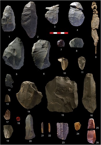
Artifacts from Kovrizhka I–V sites. 1, 2: knives, Kovrizhka IV, c.h. 3B; 3, 4: wedge-shaped microcores, Kovrizhka IV, c.h. 2B; 5, 6: side-scrapers, Kovrizhka IV, c.h. 6; 7, 8: end-scrapers, Kovrizhka IV, c.h. 6; 9: ivory anthropomorphic figurine, Kovrizhka IV, c.h. 6; 10 - wedge-shaped microcore, Kovrizhka III, c.h. 2; 11: end-scraper, Kovrizhka III, c.h. 2; 12: fragment of graphite pendant, Kovrizhka IV, c.h. 4; 13: graphite drawing artifact, Kovrizhka III, c.h. 2; 14: end-scraper and knife, Kovrizhka III, c.h. 2; 15: core, Kovrizhka III, c.h. 2; 16: macroblade, Kovrizhka III, c.h. 2; 17: transversal burin, Kovrizhka III, c.h. 2; 18: bead, Kovrizhka II, c.h. 3; 19: prismatic microcore, Kovrizhka III, c.h. 2; 20: retouched blade, Kovrizhka V, c.h. 2; 21, 22: microblade inserts, Kovrizhka IV, c.h. 1; 23: prismatic microcore, Kovrizhka IV, c.h. 1; 24: fragment of pottery, Kovrizhka IV, c.h. 1; 25, 26: end-scrapers, Kovrizhka I, c.h. 2. c.h., cultural horizon.

Artifacts from the Kovrizhka IV site. 1, 3, 5, 6, 8: c.h. 6; 2, 4: c.h. 2B; 7: c.h. 3B; 1, 3: end-scrapers; 2, 4: wedge-shaped microcores; 5: anthropomorphic ivory figurine; 6–8: side-scrapers–knives (modified from Tetenkin, Reference Tetenkin2022b). c.h., cultural horizon.

Artifacts from Kovrizhka III and Kovrizhka II sites. 1–9: Kovrizhka III, c.h. 2; 10–16: Kovrizhka II, c.h. 3; 17: Kovrizhka II, c.h. 5. 1: graphite artifact; 2, 11: burins; 3, 7, 8, 14: end-scrapers; 4, 12, 16: wedge-shaped microcores; 5: prismatic microcore; 6: flake core; 9: macroblade; 10: bead; 11: perforator; 13: biface; 17: double end-scraper (modified from Tetenkin, Reference Tetenkin2022b). c.h., cultural horizon.

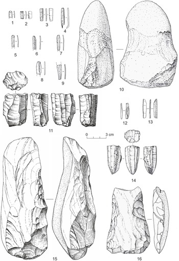
Artifacts from Kovrizhka IV site c.h. 1. 1–9, 12, 13: microblades; 10, hammer; 11, 14: prismatic microcores; 15, 16: adzes (after Tetenkin, Reference Tetenkin2022b).

Artifacts from Kovrizhka I and Kovrizhka V sites. 1–4, 6, 7: Kovrizhka I, c.h. 2; 5: Kovrizhka V, c.h. 2. 1, 2: microblades; 3, 4: end-scrapers; 5: retouched macroblade; 6, 7: side-scrapers (modified from Tetenkin, Reference Tetenkin2022b).

The Early Holocene, 11.4–8.0 ka BP, is represented by c.h. 1 of Kovrizhka IV, c.h. 1 and c.h. 2 of Kovrizhka V, cultural horizons 1, 2, 3, 4, and 4A of Kovrizhka II, and c.h. 1 and c.h. 1A of Kovrizhka III. Here, an ensemble of cultural remains have a final Paleolithic appearance (Figs. 3.18, 20 and 5.10–16) (c.h. 2 of Kovrizhka V; cultural horizons 1, 2, 3, 4, and 4A of Kovrizhka II; c.h. 1 of Kovrizhka III). Some of the artifacts have a Mesolithic appearance (Fig. 3.21–23) (c.h. 1 of Kovrizhka V; c.h. 1A of Kovrizhka III). Cultural horizon 1 of Kovrizhka IV, in which ceramics were found (Figs. 3.24 and 6), is defined as Early Neolithic. The appearance of ceramics with imprints of woven nets made it possible for the first time to characterize the formation of the Neolithic in the Lower Vitim in the broader context of Eastern Siberia (Tetenkin, Reference Tetenkin2022b).
The Middle Holocene, 6.9–6.0 ka, includes c.h. 2 of Kovrizhka I and c.h. 1 of Kovrizhka VI. In c.h. 2 of Kovrizhka I, artifacts made from argillite were found (Figs. 3.25, 26 and 7.1–4, 6, 7), identical in morphology and rock composition with argillite artifacts from the Ust-Karenga XVI site, 800 km up the Vitim River from Kovrizhka (Tetenkin et al., Reference Tetenkin, Vetrov, Demonterova, Pashkova and Kaneva2018a). These results, unique to the region, provided arguments in favor of communication that existed between two distant Neolithic groups. Culture-containing levels 1, 1A, and 1B of Kovrizhka I are dated to younger than 6.0 ka BP. However, they are represented so far by isolated, possibly redeposited finds.
During 25 years of study of Kovrizhka I–V, the importance of its contribution to the archeology of the Lower Vitim has changed. The discovery in 1995–2003 of archaeological assemblages of the Paleolithic with a Dyuktai appearance at Kovrizhka II showed for the first time the existence of such assemblages in the Early Holocene and the passage of these cultural traditions from the turn of Pleistocene–Holocene. Research of Kovrizhka III in 2003–2012 provided information on the Final Paleolithic of the Pleistocene boundary following the time of habitation of the camps of the studied multilayer site Bol’shoi Yakor’ I (Ineshin and Tetenkin, Reference Tetenkin2017). Fourteen lower cultural horizons of Kovrizhka IV studied in 2012–2023 documented for the first time late LGM LUP culture in the Vitim basin. The discovery of ceramics at Kovrizhka IV in 2018 made it possible to reasonably identify the beginning of the Neolithic in the Lower Vitim. Manysubjects of archaeological study on Kovrizhka I–VI were raised here for the first time for the archaeology of the northern Baikal region, such as the construction of dwellings; processing of building stone parts; long-distance transportation of ochre, pumice, and argillites; art in the form of a tusk anthropomorphic figure and pendants; and vertical cultural transmission exceeding 1000 years. In this cumulative sense, the Kovrizhka I–V ensemble has become a reference for the archaeology of the northern Baikal region.
Kovrizhka IV
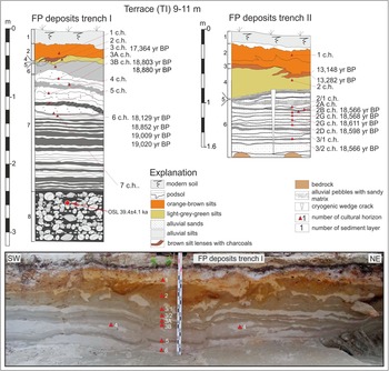
The Kovrizhka IV site is located on a 9–11 meter terrace (TI) with a rocky basement, which is a cuesta, expressed in the form of a crest. The site is located on the right bank of an unnamed creek flowing into the Vitim River at Cape Kovrizhka (Fig. 2). The total thickness of sediments at the site is more than 3.10 m (Figs. 8 and 9). In the northeastern part of the excavation, pebbles were uncovered at the base of the section at a depth of 0.90 m and in the southern part at a depth of 1.20 m. The order of the occurrence of sediments is shown in Figure 8 and described here.
Generalized stratigraphic scheme of deposits and radiocarbon dates of the Kovrizhka IV site (A). A package of culture-containing floodplain sediments (FP Unit) bears traces of lateral erosion (B).

Figure 8 Long description
A stratigraphic scheme of the Kovrizhka IV site, illustrating various sediment layers and radiocarbon dates. At the top left, labeled ′Terrace (TI) 9-11 m′, the present soil is depicted in brown. Below, paleosol is marked, followed by two erosion episodes indicated by dashed lines. FP Unit II and FP Unit I are shown in yellow, with sand and silt layers above and below them. Radiocarbon dates are displayed in blue boxes, such as 18,167 to 18,314 years before present and 18,859 years before present. The base consists of sand and pebble, with bedrock at the bottom. A red square marks the location of OSL 39.4 plus or minus 4.1 ka. The image B shows a photograph of the excavation at the site, with visible layers corresponding to the diagram. The top layer is paleosol, followed by sand and silt and FP Unit II marked with an erosion line. Below, FP Unit I is visible, consisting of sand and silt and the bottom layer is sand and pebble. A measuring stick is placed vertically in the center, providing scale and depth reference.
Detailed sections of culture-bearing sediments of the 9–11 m terrace (TI, Kovrizhka IV). The sediments in trench I reflect the dynamics of sedimentation over a period of about 40 ka. The section of sediments in trench II characterizes the sedimentation conditions over a period of about 19 ka. The photo shows the nature of the sedimentary strata of the upper part of the section of trench I.

Figure 9 Long description
The diagram consists of two main sections labeled FP deposits trench I and FP deposits trench II, both situated on a terrace labeled TI 9 to 11 m. The left section, FP deposits trench I, displays sediment layers numbered from 1 to 7, with specific years before present (BP) indicated for each layer, ranging from 17,364 to 19,022 years BP. The layers are visually represented with different patterns and colors, such as orange-brown silts, light-grey-green silts and alluvial sands. A red symbol labeled A1 indicates the presence of cultural horizons. The bottom of trench I shows a layer of alluvial pebbles with sandy matrix. The right section, FP deposits trench II, similarly shows sediment layers numbered from 1 to 3, with years BP ranging from 13,148 to 18,566. The layers are depicted with similar patterns and colors and cultural horizons are marked with red symbols. An explanation box at the bottom provides a legend for the sediment types, including modern soil, podsol and brown siltstones with charcoals. Below the diagram, a photograph shows the actual sediment layers in trench I, with markers indicating the cultural horizons and sediment layers. The photograph is oriented from southwest (SW) to northeast (NE), visually matching the diagram′s representation of sediment layers and cultural markers.
Layer 1. The soil–vegetation horizon, podzolized in the sole. Thickness: 0.10–0.15 m.
Layer 2. The sandy loam is orange-yellow and indistinctly layered, of subaerial colluvial–solifluction genesis. It contains one cultural horizon. The date of 10.1 ka (Poz–107434) was obtained from a ceramic fragment. Charcoal from a hearth yielded a date of 8.8 ka BP (SacA-75974). Thickness: 0.15–0.25 m.
Layer 3. The deformed horizon of the buried soil is a dense, bright, dark-brown sandy loam with a thickness of 0.02–0.05 m, containing charcoal in large quantities. Dates were obtained for charcoals: 13.1 ka (Poz-106967) and 13.2 ka (Poz-106963).
Layer 4. The sandy loam is light green, light brown, and indistinctly layered, of subaerial colluvial–solifluction genesis. It contains c.h. 2. Cryogenic cracks are generated from the sole, forming a polygonal network. Thickness: 0.05–0.20 m.
Layer 5. The sand horizon is a yellowish, fine-grained layer with rounded pieces of black slate. It is subject to cryogenic deformation, which is caused by solifluction processes. The horizon manifests itself as an independent layer or in the form of injection spots. Thickness: 0.01–0.30 m.
Layer 6. A package of sediments of floodplain alluvium—rhythmically and horizontally layered sands, sandy loams, and silts (Floodplain Unit II) that include cultural horizons 2/1, 2A, 2B, 2B, 2G, 2D, 3/1, and 3/2. Dates were obtained for c.h. 2B: 18.3 (Poz-106023), 18.5 (LTL-16563A), and 18.8 ka (Poz-106962); for c.h. 2G: 18.5 (Poz-111232), 18.6 (Poz-111356), 34.9 (Poz-106961), and 35.6 ka (Poz-106960); for c.h. 2D: 18.6 ka (Poz-106968); and for c.h. 3/2: 18.5 ka (Poz-106965) and 18.2 ka (SacA-75975). This package is embedded in the sediments of the previous cycle, partially destroyed by river erosion, observed as a layer of dark gray sandy loam containing c.h. 3/1 and c.h. 3/2. In the northern part of the excavation, these sediments are superimposed on the undisturbed part of layer 7; closer to the northern corner of the excavation and the outer edge of the ravine, they merge compressionally into the undifferentiated third cultural horizon. Thickness: 0.30–0.90 m.
Layer 7. A package of alternating light gray sand and dark gray sandy loams and silts (Floodplain Unit I) unconformably overlies layer 8. The thickness of the layers is 2–4 cm. In the lower part, there is an abundant inclusion of small, rounded shales in some horizons. In the upper part, in layers of dark gray sandy loam and silts, cultural horizons lie from top to bottom: 3A, 3B, 4, 5, 6, and 7. Dates were obtained for c.h. 6: 18.1 (UGAMS–27448), 18.8 (Ua-50437), 19.0 ka (LTL-16562A), and 19.0 (Beta–453119). Two age of 18.8 ka (Poz-131810 and Poz-131812) were obtained for c.h. 3B. Closer to the river, the package is eroded by flooding. The erosion line is oriented from west to east, to the tip of Cape Kovrizhka. The surface of the washout is clear, uneven, and stepped. Thickness: 0.70–1.50 m.
Layer 8. Ginger and grey sand-gravel deposits with inclusions of various boulders up to 30 cm in diameter. The deposits are poorly sorted. Small varieties are poorly rolled. Pebbles and boulders are well rolled. In the infill, the sand is well sorted, coarse-grained, and gray in color. An OSL date of 39.4 ± 4.1 ka was obtained from the upper part (Riso-208499). The apparent thickness is 0.6 m or more.
In alluvial deposits (layers 6 and 7), sedimentation blocks with vertical and horizontal displacement with an amplitude of up to 10 cm are noted.
Initially, the interpretation of the age of culture-containing deposits on Kovrizhka IV was based on general ideas about the Holocene age of the 9–11 m Vitim terrace. This was evidenced by all previous archaeological work on the sites located on this terrace: Invalidny III, excavation area 1–3; Mamakan I–V; and Kovrizhka I (Belousov et al., Reference Belousov, Ineshin, Sulerzhitsky and Tetenkin2002). The date 8.8 ka BP (SOAN-7294), obtained from charcoal found in a molehill from the layer containing c.h. 5, did not contradict this age estimate. A date of 9.3 ka (SOAN-8839), obtained by the oscillation method from a bulk charcoal sample from c.h. 6, confirmed this interpretation. However, unexpectedly, an AMS radiocarbon date of 18.8 ka BP (Ua-50437) on bone from c.h. 6 significantly increased the age. Further confirmation was obtained through the AMS dating of two samples of snow sheep tooth enamel from the cultural horizons 6 and 3: 18.1 (UGAMS-27448) and 17.4 ka (UGAMS-27447). The dates were made using bioapatite, and although bioapatite dating is not considered as reliable (Cherkinsky, Reference Cherkinsky2009; Zazzo and Saliège, Reference Zazzo and Saliège2011), these dates still suggest a Pleistocene age for the deposits. Moreover, the date of c.h. 3 suggested that the entire stack of cultural alluvial deposits may be of Pleistocene age. Then, with the help of anthracologist A. Henry, samples of willow (Salix) charcoal, which makes up a majority of wood charcoal in c.h. 6 and c.h. 2B, were dated to 19.0 (LTL-16562A) and 18.6 ka (LTL-16563A), respectively. Another AMS date of 19.0 ka (Beta-453119), which turned out to be almost identical with the previous one, was obtained on willow charcoal from the second hearth in the dwelling of c.h. 6. Thus, three dates (19.0, 19.0, and 18.8 ka) for c.h. 6 and a date of 18.5 ka for c.h. 2B have put an end to the question of the Pleistocene age of alluvial culture-bearing deposits. These horizons proved to be the oldest in the Vitim catchment with clearly stratified archaeological deposits.
The next contribution to radiocarbon chronology was a new series of 12 AMS dates on culture-bearing deposits at the site. Four dates for 2B, 2G, and 2D cultural horizons at ∼18.5 ka show a very small chronological gap between the horizons and agree satisfactorily with one another. The dates of 35.2 and 34.9 ka for c.h. 2G are older than expected and can be explained by the entry into the layer of MIS 3 wood (brought by the river) and used at a later time by people for household needs. The date of 18.5 ka BP for c.h. 3/2 should be older, because c.h. 3/2 lies stratigraphically below the 2A, B, V, G, and D cultural horizons. A bone date of 18.1 ka of c.h. 2B is somewhat younger than the dates for charcoal from the same horizon (18.5 ka BP). Similarly, the date 18.8 ka on a bone from c.h. 6 is younger than two charcoal dates ∼19.0 ka from the same context. Shrub willow was defined as the dominant taxon in charcoal accumulations, so the charcoal dates are accepted as a reference in the radiocarbon chronology of Kovrizhka IV site.
Based on the growth and wear patterns of snow sheep teeth, winter habitat seasons were determined for sites in c.h. 6 and c.h. 2B and spring habitat season for a site in c.h. 3B (Teten’kin et al., Reference Teten’kin, Smith and Henry2016; Tetenkin et al., Reference Tetenkin, Henry and Klementyev2017). Furthermore, the site’s location on a beach coastal strip was taken into account, as it was safe only during flood-free periods, that is, from autumn to spring.
Assemblages from c.h. 7 to c.h. 2A date to the early stage of the LUP (Tetenkin, Reference Tetenkin2025). The technical contexts have been determined: (1) production of microblades for insert hunting weapons, obtained by pressing from wedge-shaped microcores (Fig. 3.3, and 4.2, 4); (2) production of flakes by flaking from pebble cores—most of the tools are spalls with used, non-retouched edges; (3) production of macroblades up to 12 cm long (Fig. 3.2); and (4) production of coarse prismatic blades up to 5 cm long. Morphologically expressed tools are side-scrapers, end-scrapers, piѐce esquillée, and a median burin (Figs. 4.1, 3, 6–8 and 3.1, 2, 5, 6). An anthropomorphic figure made from a mammoth tusk blade was found (Fig. 3.9 and 4.5).
The age of c.h. 2 is calculated based on the fact that it is covered by a buried soil with dates of 13.1 and 13.2 ka. The lower age limit of c.h. 2 is controlled by the flood layer of light yellow sand (layer 5) underlying the subaerial package. This flood destroyed the upper part of the underlying package of floodplain alluvium. Radiocarbon and stratigraphic data establish the age of c.h. 2 to be in the range of about 13.2–13.1 ka. Cultural horizon 2 stone artifacts are LUP in appearance, displaying similarities with previous cultural horizons, for example, wedge-shaped microcores, end-scrapers, and side-scrapers. The artifacts were made primarily from locally available pebbles of volcanic rock and mudstone, as well as quartz.
A date of 10.1 ka (Poz-107434) was obtained on carbon directly on ceramic from c.h. 1. Unfortunately, the sample submitted for dating did not contain any carbon or organic matter. Therefore, the received date is assessed as invalid, namely, overdated. Therefore, the obtained date is considered to be too old. A more acceptable age is 8.8 ka (SacA-75974), obtained on charcoal from hearth 1 of the cultural horizon. The stone artifacts consist of prismatic microblade cores, flint microblades, chipped pebble adzes, and a hammer-pestle (Figs. 5 and 7.21–23). The ceramics bear the technical imprint of woven nets (Fig. 7.24).
The flood horizon (layer 5, erosion episode 3) destroyed deposits that could have accumulated after 18 ka. This episode, older than 13.2 ka, is logically associated with a sedimentation break on Bol’shoi Yakor’ I, where there is a break between the alluvial Pleistocene sediments and the Middle–Late Holocene subaerial package. The last cultural horizon in the floodplain alluvium on Bol’shoi Yakor’ I site—c.h. 3A—has a date of ∼13.6 ka (Ineshin and Tetenkin, Reference Tetenkin2017). Based on this correlation, the age of layer 5 at Kovrizhka is probably 13.5–13.2 ka.
Erosion episode 2 falls stratigraphically between the 3/2 and 3A cultural horizons. Its age is about 18.6 ka. The unconformity, fixed in this section, is an erosive shore edge. There are 14 cultural horizons associated with this feature; of which 6 are laid down before unconformity and 8 afterward, which indicates a preference for people to settle on the beach, near the water’s edge. On this landscape, safe seasonal long-term base camps could exist only in seasons with zero (minimal) flood activity, that is, from autumn to early spring.
The age difference of about 20,000 years between the ages of layer 8 and layer 7 indicates an incision or erosion occurred within this time, producing an unconformity identified as erosion episode 1. Layer 8 dates to MIS-3, and the variable roundness and poorly sorted boulder–pebble materials indicate the rapid nature of the water flow that deposited these sediments.
In summary, 16 cultural horizons have been identified at Kovrizhka IV: 14 horizons in alluvial sediments dating to the LUP, 19.2–18.5 ka; c.h. 2 dating to the Final Paleolithic, 13.4 ka BP; and c.h. 1 dating to the EN 8.5–8.0 ka BP.
Kovrizhka III
The Kovrizhka III site is located on the right bank of the Vitim River nearby Kovrizhka IV (Fig. 2). The main excavation is laid on a cape-shaped ledge of the 22 m Vitim terrace. It also includes an adjacent slope with a relative height of 24, 29, and 35 m from the edge of the Vitim River and up to 260 m from the shore. The slope topography has the character of terraced steps in the form of transverse ridges separated by small ravines.
The excavation is situated on the surface of the terrace at an altitude of 22.5 m from the shoreline of the Vitim and 176 m from the edge of the shore, oriented along the north-south line. The sediment sequence on the eastern wall is shown in Figure 10 and described here.
(A) Diagram shows the main terrace deposits (TIII) formed by aquatic and subaerial sedimentation. The deposits are rich in artifacts reflecting the stages of occupation of the emerging surface. Photographs (B–D) show details of the deposit structure with cultural horizons and artifact inclusions.

Figure 10 Long description
Cross-sectional diagram of terrace deposits labeled Terrace TIII at 22 meters. The diagram is oriented from north to south, with the Vitim River indicated to the north. Various sediment layers are depicted, including yellowish-brown silts, brownish silts with lenses and grayish sands. The layers are marked with different patterns and colors and labeled with their respective ages in years before present, ranging from 12,194 to 13,263. The diagram includes labels for the upper and lower levels of cultural horizons, ch. 1 and ch. 2 and the positions of gneiss slabs. A scale bar is present at the bottom. Photograph of an excavation site with a measuring rod on the left, labeled 1A and 1. Another excavation view with a measuring rod in the center, showing the upper and lower levels of ch. 2, labeled 1 and 1A. Close-up of the sediment layers with a measuring rod on the right, labeled 1, 1A and 2, showing the stratification of the deposits.
Layer 1. Soil horizon. Thickness: 0.10–0.12 m.
Layer 2. Podzolic horizon. The sole of the layer has a broken appearance due to frost wedges entering the underlying layer and curving up the slope. Artifacts from the 0th cultural horizon were recovered in the roots of the trees and under the stumps. Thickness: 0.02–0.05 m.
Layer 3. Red-brown sandy loam, indistinctly layered. The sole is wavy, thickness is 0.08–0.20 m.
Layer 4. Greenish-light brown silt with scattered brown silt layers, to which the 1 and 1 A cultural horizons are sequentially confined. The age of 9.0 ka (SOAN-8262) was obtained for charcoal from c.h. 1. The ages of 9.08 (SOAN-7027) and 9.2 ka (SOAN-7965) were obtained for charcoals from c.h. 1A. Cultural horizon1A—in the middle part of the layer—is underlain by a light gray layer of fine-grained sand, schlier (horizontal permafrost rupture) with a thickness of up to 1.5 cm. The bending of this layer downward in the rear part of the excavation and its contact with the underlying sand of layer 5 has been traced. Below this interlayer, up to the sole of the layer, c.h. 2 is delineated. The lenses of the hearths in the upper and lower parts are fixed in it. For charcoals, the dates 12.2 (SOAN-7964) and 12.9 ka (SOAN-7966) were obtained from the upper and lower hearths, respectively. Hence the upper and lower levels of c.h. 2 are delineated. Cryogenic cracks are embedded from the sole of the layer, which is deformed by solifluction processes. The sands of the underlying layer are drawn in the solifluction tongues. In the lower, raised part, lies c.h. 3 in a brown lens with charcoals dating to 13.2 ka BP (SOAN-8261). Thickness: 0.24–0.28 m.
Layer 5. A package of alluvial layers of medium-grained sand, interlacing with layers of whitish-pale gray aleurite, cryogenically deformed, gleyed, with spots of oxidation, with inclusions of small pebbles. Thickness: 1.15–1.25 m.
Layer 6. Coarse-grained alluvium, consisting of rounded and unrounded pebbles, blocks, and boulders up to 40 cm in diameter, with a sand–gravel matrix. These deposits are unsorted and unstratified and can be interpreted as megaflood deposits. The deposits are heavily oxidized, especially in the upper part. A sample (Kov-24-1) was taken from the coarse-grained alluvium for OSL dating: 23 ± 2 ka BP (RGI-1363) (Arzhannikova et al., Reference Arzhannikova, Arzhannikov, Tetenkin, Chebotarev, Timofeeva, Efremova, Gladkochub and Bryanskiy2025). The apparent thickness is 0.6 m or more.
The total thickness of the exposed loose deposits is 1.90 m.
Cultural horizons 3 and 2, dated to 13.2–12.2 ka, lie in the lower part of layer 4, which is of subaerial genesis (Final Paleolithic, Bølling-Allerød–Younger Dryas). In the upper part, c.h. 1A and c.h. 1 with an age of 9.2–9.0 ka (Mesolithic, Early Holocene) were discovered in the buried soils scattered along the slope. The floodplain alluvium of this third terrace (TIII), lying below, is defined as deposits of the MIS 2. Its age of 23 ± 2 ka correlates with the OSL dating of sediments in the middle part of the quarry of the 19 m alluvial pack of Mamakan VI sediments (22 ± 1 ka) (RGI-1364) and is determined as the time of the last ice-dammed paleolake outburst flood (Ulan-Makit paleolake) ∼22.3–21 ka (Arzhannikova et al., Reference Arzhannikova, Arzhannikov, Tetenkin, Chebotarev, Timofeeva, Efremova, Gladkochub and Bryanskiy2025).
Cultural horizons 2 and 3 are close to each other; their tool kits consists of wedge-shaped microcores and microblades, pebble cores with parallel and radial flaking, choppers, side-scrapers, end-scrapers, transverse burins made of effusive rocks, and multifaceted burins made of quartz (Figs. 3.10, 11, 13-19 and 5.1-9). They are also quite similar to the collection from Kovrizhka IV, c.h. 2, and overall have an LUP appearance.
Cultural horizon 1A consists of end-scrapers and microblades made of flint and volcanic glass and has a Mesolithic appearance. The materials from c.h. 1 are few and inconspicuous.
Kovrizhka II
Kovrizhka II is located on the 17–19 m terrace (TII) (Fig. 2). The site was partially destroyed by a road quarry. The terrace edge has been preserved undisturbed. Riverbed deposits (pebbles and sands) have been uncovered by the quarry. In the edge part of the terrace, there is a rocky outlier, to which alluvial deposits are conjoined (Fig. 11).
The general scheme of the structure of sediments and radiocarbon dates of the terrace (TII, Kovrizhka II), including cultural horizons saturated with traces of ancient human activity (A and B). Photo (C) shows the clearing of the hearth of c.h. 5, arranged by the inhabitants at the rock wall—a windbreak shelter.

Figure 11 Long description
The image consists of three parts labeled A, B and C. In A, a cross-section of Terrace TII is depicted, showing various sediment layers with radiocarbon dates labeled as 9132 years before present, 9200 years before present and 19,328 years before present. The section includes cultural horizons marked as c.h. 5, 4 and 3, with a legend explaining different soil types and features such as yellow loess, brown loam and pebbles with charcoal. The diagram indicates the direction towards the Vitim River. In B, a vertical profile of cultural horizons is shown, with similar radiocarbon dates and labeled horizons. The profile is marked with a scale in meters. In C, a photograph shows two individuals working at an excavation site, clearing a hearth at the rock wall, which serves as a windbreak shelter. The image provides a visual representation of the archaeological context and stratigraphy of the site.
The stratigraphy of the excavation site at the location of Kovrizhka II is shown in Figure 11A–C and described here.
Layer 1. Soil and vegetation horizon. Thickness: 0.13–0.24 m.
Layer 2. Podzolic horizon. The first cultural horizon lies in contact with the underlying layer. Thickness: 0.07–0.02 m.
Layer 3. A horizon of orange-yellow, clay, fine-sandy, deformed sediments with traces of podzolization. The sole of the layer is soliflucted. The cultural remains contained in it are allocated to c.h. 2; the main materials lie in the upper part of the layer, and few finds are found throughout the lower part of the layer. Thickness: 0.19–0.28 m.
Layer 4. Fragments of a ruptured deformed horizon of dark-pale fine-grained aleurite. The upper part of the horizon was destroyed by the overlying layer 3. Thickness: 0.03–0.12 m.
Layer 5. The horizon of a thinly micro-layered, silty, light-green aleurite. In the lower part of the horizon, there is a slight ferruginization. In the dried state of the layer, horizontal layering is observed along micro-layers with a thickness of up to 0.01 m. The upper part of the layer accommodates two levels of cultural remnants: c.h. 3 and c.h. 4. A radiocarbon age of 9.1 ka (SOAN-5277) was obtained from c.h. 3. In the middle part of the layer lies a layer saturated with charcoal particles with a thickness of up to 2–3 cm and containing c.h. 4A. It has a radiocarbon age of 9.2 ka (SOAN-5276). On the upper surface of the artifacts in c.h. 3, c.h. 4, and c.h. 4A, a clay sheet is marked. Small cryogenic cracks, nested one within the other, are laid from the upper part of the layer and from the base. The sinking of cultural remains into the crack was noted. The upper crack is poorly readable in the section, so it is difficult to determine whether the shoulders of the upper crack lie above or below relative to c.h. 3, c.h. 4, and c.h. 4A. Light gray sandy layers with a thickness of up to 2 cm are noted in the sole of the layer. Thickness: 0.60–0.65 m.
Layer 6. Horizontally layered light gray sand with interlayers of silty aleurite/silt similar to layer 5. The layer is ruptured by cryogenic cracks from the overlying layer 5. Thickness: 1.05–1.08 m.
Layer 7. Package of bluish-dark gray horizontally layered fine-grained sands up to 2 cm thick with layers of light gray medium-grained sand. In the lower part of the layer, a light gray sandy layer has a thickness of up to 6 cm. The deposits are ruptured by cracks from layer 5. Cultural horizon 5 lies in the upper part of the layer. A 14C date of 13.0 ka (SOAN-4543) was obtained from it using the scintillation method in the 2000s, and a 14C AMS date of 19.9 ka (SacA-75973) was recently obtained. Thickness: 0.24–0.70 m.
Layer 8. Light gray medium- and coarse-grained rhythmically layered sand with inclusions of gravel. Thickness: 0.60–0.70 m.
Layer 9. The boulder–pebble layer is unsorted, with gruss and sand in the filling. Thickness: 0.10–0.50 m.
Layer 10. A layer of coarse-grained sand with gruss. A distinct lens of thin-layered sand (layer 11) is marked in the middle part of the layer. Thickness: 0.60–0.80 m.
Layer 11. A lens of obliquely layered silt and fine-grained sands with layers of gray coarse-grained sand. Thickness: 0.01–0.50 m.
Layer 12. A layer of obliquely and rhythmically layered silt and fine-grained sands with layers of gray coarse-grained sands. Thickness: 0.55–0.70 m.
Layer 13. A layer of coarse-grained sand with gruss. Thickness: 0.05–0.20 m.
Layer 14. Gray rhythmically layered coarse-grained sands with layers of silty fine-grained sands. This layer has the opposite orientation of layers in 11 and 12. Thickness is up to 0.80 m or more.
The total thickness of the exposed deposits reaches 4.5 m.
Sediments in layers 14–8 belong to the channel alluvium, layers 7–6 represent the floodplain alluvium, sediments 5–3 were formed in subaerial conditions, experiencing the processes of pyrogenesis, cryoturbation, and sedimentation, and layer 1 is the modern soil layer. A stratigraphic unconformity is observed between layers 5 and 6, indicating a hiatus in sedimentation. This hiatus could have been caused by either flood erosion of some of the floodplain facies sediments or by subaerial denudation processes, which halted sedimentation in this area. Layer 9 (an unsorted boulder–pebble layer with debris and sand in the fill) is correlated with the pebble layer 6 of Kovrizhka III and the last megaflood of ∼22.3–21 ka.
Cultural horizon 5 is a sparse accumulation of cultural remains near a hearth located behind a rock outcrop (Fig. 11C). These remains include only one scraper and a few flakes (Tetenkin, Reference Tetenkin2010).
Cultural horizons 4A–1 are generally similar to one another and to assemblages from the preceding period, the end of MIS-2. This is a set of pebble cores with a parallel flaking principle, wedge-shaped microcores and microblades, side-scrapers, end-scrapers, perforators, and retouched flakes of an LUP appearance (Figs. 3.18 and 5.11-17).
Kovrizhka V
Kovrizhka V is situated on a 9–11 m terrace (TI) 30 m from the river’s edge, at the base of the ledge of a 17–19 m terrace (TII) (Fig. 2). Excavation revealed the sequence of deposits illustrated in Figure 12 and described here.
The section of the terrace sediments (TI, Kovrizhka V site) reflecting the dynamics of sedimentation (A). Photo (B) shows buried soil horizons and culture-containing sediments.

Figure 12 Long description
Sediment layers at Terrace 9-11 m (TI), illustrating various geological strata. The layers are labeled with different textures and colors, representing modern soil, podzol, orange-brown silts, light-grey-green silts with lenses of brown silts, medium-grained sands and black silt lenses with charcoals. Each layer is marked with its corresponding age in years before present, ranging from 814 to 14138 plus or minus 138 years before present. The diagram includes arrows indicating the direction to the Vitim River and an explanation key at the bottom detailing the symbols used for artifacts, cultural horizons, sediment layers, cultural horizons and lithological layers. A photograph of an excavation site at the same terrace, with a vertical measuring stick marked with numbers 1 to 4, indicating different layers or horizons. The excavation reveals distinct layers of soil, with visible color changes and textures. The direction to the Vitim River is indicated at the top and the photograph is oriented from west to east. The measuring stick provides a scale for the depth of the excavation and the numbers correspond to the explanation key provided in image.
1. The subaerial slope pack of orange-yellow and light-green sandy loams has the same composition as that in the Kovrizhka IV section, but is less susceptible to solifluction. Contact with the underlying deposits of layer 1 is at a depth of 0.85 m. At the base of member 1, in a pyrogenic interlayer, lies c.h. 1 dating to 8.3 ka (SOAN-8838, date obtained by the oscillatory method) (Early Neolithic) (Table 1). Judging by the AMS age from the underlying level, the age of c.h. 1 should be closer to 10.5 ka.
2. The unit is up to 3 m thick or more and consists of yellow-gray, brownish, greenish-gray fine-grained sands with wavy bedding, interbedded with pyrogenic, intensely coal-saturated, eroded horizons. The nature of the deposits (periodic flooding of the surface exposed to fires) corresponds to the floodplain facies of alluvium. The age of 10.6 ka (SacA-75972) was obtained from the buried soil in the top of the unit underlying the first cultural horizon. Cultural horizon 2 was found at a depth of about 1.2 m and yielded dates of 11.5 ka (SOAN-8837) and 12.1 ka BP (SacA-75971) (Final Paleolithic). Cultural horizon 3 was found at a depth of about 2.0 m and yielded dates of 12.9 ka BP (GV-05544) and 12.8 ka (SacA-75970) (Final Paleolithic). Cultural horizon 4 was identified in the underlying layer. Dates of 13.2 ka BP (SacA-75969) and 14.1 ka (SacA-75968) were obtained from depths of 2.35 and 3.5 m, respectively.
The transition from the floodplain to the terrace in this section of the valley is noted at a depth of 0.85 m from the daylight surface and is dated between 10.6 ka BP (the date was obtained from the charcoal-rich horizon at the top of layer 2) and 8.3 ka (the age was obtained from the pyrogenic layer at the base of layer 1).
Cultural horizon 1 contains a few finds of prismatic flint blades and flakes. Charcoal from this layer yielded a date of 8.3 ka (SOAN-8838). Cultural horizon 2 includes a retouched blade, retouched flakes, and pebble debris from effusive rocks. This assemblage has an LUP appearance (Figs. 3.20 and 7.5). Finds from c.h. 3 are few in number. In terms of substrate and morphology, they are similar to those from c.h. 2.
Kovrizhka I
Kovrizhka I is located in the ravine part of the first terrace (TI) at a height of 10.9 m from the Vitim River, 60 m from the shore (Fig. 2). A description of the test pit is provided here.
Layer 1. Soil and vegetation horizon. Thickness: 0.14–0.26 m.
Layer 2. Charcoal, bright black medium sandy loam. Thickness: 0.03–0.16 m.
Layer 3. Pale orange-yellow, gray-yellow light sandy loam, ferrugination layered, cryogenically deformed, torn, with charcoal layers up to 0.04 m thick containing detritus lenses. The layering of the interlayers is indistinct due to blurring. Cultural horizon 1 is located in the middle part of the layer, within a charcoal layer. An end-scraper, representing c.h. 1A, was found 50 cm below c.h. 1. Thickness: 0.48–1.10 m.
Layer 4. Gray cryogenically deformed sandy loam, indistinctly layered with spots of calcification, charcoal layers up to 0.04 m thick, with inclusions of small flat pebbles of carbonaceous shale lying flat, up to 0.008 m in size. In the raised part, three flakes were found representing c.h. 1B. Thickness: 0.35–0.60 m.
Layer 5. Culture-containing (c.h. 2) cryogenically deformed grayish-pink sand. In the upper contact with layer 5, there is a charcoal layer, which also contains detritus. The thickness of the interlayer is 0.01 m. Thickness: 0.10–0.50 m.
Layer 6. Light gray sand, cryogenically deformed resulting in discontinuous stratigraphy. Thickness: up to 0.60 m or more.
Layer 7. Light and dark gray indistinctly layered cryogenically deformed sand with inclusions of charcoal, with lenses of dark gray charcoal-saturated sand. One of these lenses contained a core representing c.h. 3. Thickness: up to 0.35 m or more.
The total depth of the loose sediments uncovered by the test pit is 2.10 m. The permafrost is fixed at a depth of 1.25 m.
The age of the culture-containing carbonaceous layer of c.h. 1 is 2.9 ka (GIN-9003). Taking into account the sloping aeolian–diluvial nature of the deposits of lithological layers 3 to 4, the discontinuity of culture-containing layers, and the vertical and inclined position of the finds and their uniqueness, it should be concluded that the upper c.h. 1, c.h. 1A, and c.h. 1B were deposited by the removal of artifacts by sloping processes from the above levels. Lithological layer 5, containing c.h. 2, has a thickness of 0.08–0.20 m. Its deformation appears to be complex due to both slope drift and cryogenic disturbances. Charcoal from this horizon yielded dates of 6.9 (SOAN-4245) and 6.7 ka (SOAN-4545) (Table 1). The single finds of c.h. 3 lie at the top of the floodplain of the 9–11 m Kovrizhka terrace.
Cultural horizons 1, 1A, and 1B are represented by isolated artifacts, while c.h. 2 contains end-scrapers made of brown exotic mudstone blades (Figs. 3.25, 26 and 7.3, 4). X-ray fluorescence (XRF) studies revealed a near-identical compositional match between the stone and morphologically similar end-scrapers made of blades from the Ust-Karenga XVI site, located 800 km upstream of the Vitim River (Tetenkin et al., Reference Tetenkin, Vetrov, Demonterova, Pashkova and Kaneva2018a). The remaining artifacts are made of flint and effusive rocks. In general, here and in other archaeological assemblages of Kovrizhka I–VI, flint appears only in Mesolithic–Neolithic cultural assemblages in the Holocene. The materials from c.h. 3 are few in number and of little diagnostic value. They are made of effusive rocks.
Kovrizhka VI
The Kovrizhka VI site is located on a small cape of bedrock of the Vitim River at a height of 5 m above the water level. A test pit excavated to a depth of 1.90 m revealed three layers described here.
Layer 1. Soil and vegetation horizon. Thickness: 0.10–0.16 m.
Layer 2. A package of light gray indistinctly layered sands with inclusions of plant organic matter with a thickness of up to 0.40 m.
Layer 3. A package of dark and light gray rhythmically layered sands with inclusions of lenses of vegetable detritus and carboniferous wood with a thickness of up to 1.1 m, lying on boulder–pebble deposits. A prismatic core and sinker representing the first cultural horizon of the Neolithic were revealed in layer 1.
Discussion
Chronology of geological events in the Vitim River valley over the last 56,000 years
The geoarchaeological study of the Kovrizhka I–VI sites, located on the floodplain (HFP), three terraces (TI, TII, TIII), and upper slope, allowed us to build a synthetic model of the formation of the Vitim River valley (the area of the archaeological ensemble “Kovrizhka”) and reconstruct the conditions of settlement and habitation of its people during MIS III–I. Schematically, the paleogeographic reconstruction is presented in seven stages (Fig. 13).
Reconstruction of sedimentation dynamics over the last 22.3 ka and human development of the Kovrizhka tract in the period 19.2–6.7 ka ago.

Figure 13 Long description
Eight line graphs labeled A to H, showing distance versus height profiles along the Vitim River. Each graph represents different sedimentation and erosion episodes from MIS 2 to the Middle Holocene. The horizontal axis shows distance in meters from 0 to 225 and the vertical axis shows height in meters from 0 to 40, representing relative elevation above the river. Graph A shows accumulation-erosion episode 1 during Early MIS 2 to LGM, 22.3 to 19.9 ka. The profile line rises from near 0 to near 40 meters, with a marked step around 90 meters. Erosion is noted and sediment accumulation is minimal. Graph B depicts a cumulative episode from Early MIS 2 to Late LGM, 19.9 to 18.6 ka. Sediment bodies appear in the lower section, expanding from 0 to 90 meters, indicating accumulation. Graph C shows erosion episode 2 during Early MIS 2 to Late LGM, 18.6 to 18.5 ka. Erosion is highlighted near the mid-profile step, with minimal sediment presence. Graph D represents a cumulative episode after Late LGM, 18.6 to 18.5 ka. Sediment packages expand and stack, with multiple levels labeled, indicating significant accumulation. Graph E illustrates erosion-accumulation episode 3 during BA, 13.6 to 13.4 ka. Erosion is noted, with some sediment accumulation near the lower profile. Graph F shows a cumulative episode from BA to YD, 13.4 to 12.0 ka. Sediment bodies expand further, with levels labeled, indicating continued accumulation. Graph G depicts a cumulative episode during the Early Holocene, 12.0 to 8.3 ka. Sediment packages continue to grow, with multiple levels labeled, showing ongoing accumulation. Graph H represents a cumulative episode during the Middle Holocene, 8.3 to 6.0 ka. Sediment bodies are well-developed, with levels labeled, indicating mature accumulation. The legend explains visual differentiation: pink represents alluvial pebbles, gray shades indicate sands and silts, brown/orange denotes subaerial slope loams, dashed lines mark artifact levels and dotted lines indicate eroded contacts. The graphs collectively illustrate the progression of sedimentation and erosion along the river terrace over time.
Stage A
The specifics of sedimentation in the valley of the Vitim River from Lake Oron to the confluence with the Lena River is that during the Late Pleistocene this area was affected by megafloods associated with the periodic descent of the glacier-dammed Vitim paleolake (Margold et al., Reference Margold, Jansen, Codilean, Preusser, Gurinov, Fujioka and Fink2018; Arzhannikova et al., Reference Arzhannikova, Arzhannikov, Tetenkin, Chebotarev, Timofeeva, Efremova, Gladkochub and Bryanskiy2025). The maximum volume of water in the paleolake reached 3000 km3, and its discharge along the Vitim valley could significantly transform existing landscapes and change the composition of all types of sediments that fell into the zone of dynamic influence of glacial superflood both in the main valley and in the lateral tributaries. According to Margold et al. (Reference Margold, Jansen, Codilean, Preusser, Gurinov, Fujioka and Fink2018), three megafloods have occurred over the past 60 ka. The average depth of the stream reached 120–150 m. One of the events of this type (Flood I) occurred at 56 ka (Margold et al., Reference Margold, Jansen, Codilean, Preusser, Gurinov, Fujioka and Fink2018) or 53–52 ka (Arzhannikova et al., Reference Arzhannikova, Arzhannikov, Tetenkin, Chebotarev, Timofeeva, Efremova, Gladkochub and Bryanskiy2025). It is recorded in the topography of a large spillway located 22 km below Lake Oron and flood deposits lying on the slope of the Vitim River valley (h = 70–80 m) 12 km downstream from Bodaibo city.
The next megaflood in the Late Pleistocene was Flood II. Its formation time is assumed to be 37.5–37 ka (Arzhannikova et al., Reference Arzhannikova, Arzhannikov, Tetenkin, Chebotarev, Timofeeva, Efremova, Gladkochub and Bryanskiy2025). In the bottom of the floodplain in deposits of the first and second terraces at the Kovrizhka IV site, a pebble with an age of 39.4 ± 4.1 ka (Tetenkin, Reference Tetenkin2022b) was OSL dated (Figs. 8 and 13A). The boulder–pebble layer is poorly sorted and poorly rolled, which indicates its formation by a rapid flow.
The third outburst flood (Flood III), determined in this part of the valley from poorly sorted pebble deposits of the second (Kovrizhka II) and third (Kovrizhka III) terraces and Mamakan VI, is dated to ∼22.3–21 ka (Arzhannikova et al., Reference Arzhannikova, Arzhannikov, Tetenkin, Chebotarev, Timofeeva, Efremova, Gladkochub and Bryanskiy2025).
Thus, the lower part of the Vitim valley, starting from the Muya Basin and up to the confluence with the Lena River, has developed a unique sedimentation history, which is fundamentally different from the rest of the large drainage systems of the Baikal-Patom Highlands.
In previous studies (Zolotarev, Reference Zolotarev1974a, Reference Zolotarev1974b; Tishchenko, Reference Tishchenko and Logachev1982) abnormal changes in the height of terraces at short distances, both in the valley of the Vitim River and in the lateral tributaries, have been noted. This feature is associated with a change in the alluvial thickness along the longitudinal profile of the valley and is characteristic of the megaflood deposits, both in Siberia and in other regions of the world (Baker and Bunker, Reference Baker and Bunker1985; Parnachev, Reference Parnachev1999; Zolnikov and Mistryukov, Reference Zolnikov and Mistryukov2008; Komatsu et al., Reference Komatsu, Arzhannikov, Gillespie, Burke, Miyamoto and Baker2009; Arzhannikov et al., Reference Arzhannikov, Arzhannikova, Braucher and Komatsu2023). The reverse pattern is observed in the lateral tributaries, where the maximum height of the terraces is confined to the mouth of the valley and decreases toward the upper reaches of the river.
Stage B
The earliest identified traces of human habitation date back to ∼19.9 ka in c.h. 5 of Kovrizhka II (T II), formed after the Flood III event. Subsequently, the Vitim River incised into the gravel on the first terrace, and the deposition of floodplain facies deposits began below, that is, on the first terrace. Cultural horizons 3A–7 of Kovrizhka IV indicate human migration following the shift in the shoreline.
A floodplain consisting of rhythmically layered deposits covers the preserved and partially eroded pebble horizon deposited by a megaflood on Kovrizhka IV. In the upper part, the floodplain sediments contain cultural horizons 3A, 3B, 4, 5, 6, and 7 (Figs. 8 and 13B). The age of these horizons is 19.2–18.6 ka. Judging by the dates of these horizons, the estimated age of the beginning of floodplain accumulation is ∼19.9 ka. This coincides with the late phase of the LGM and the beginning of incision, which was followed by a stage of floodplain accumulation of alluvium on Kovrizhka IV. It should be noted that there is a large chronological gap, about 20,000 years, between the beginning of the formation of the floodplain alluvium and the age of the underlying pebble horizon. This can only be explained by the erosion-incision of Vitim River into the fluvial deposits left by the second flood (Flood II) (Margold et al., Reference Margold, Jansen, Codilean, Preusser, Gurinov, Fujioka and Fink2018; Arzhannikova et al., Reference Arzhannikova, Arzhannikov, Tetenkin, Chebotarev, Timofeeva, Efremova, Gladkochub and Bryanskiy2025).
Stages C and D
Deep erosion in the valley of the Vitim River was apparently accompanied by lateral erosion during the floods. This led to erosion of part of the floodplain alluvial package on Kovrizhka IV (Figs. 8 and 13C). On the eroded part, new deposits of the same floodplain genesis were formed, which are leaning against the deposits of the previous stage of floodplain sediments (Figs. 8 and 13D). They contain cultural horizons 2/1, 2A, 2B, 2C, 2D, 3/1, and 3/2. The age of these deposits is close to that of the previous horizons: 18.6–18.5 ka. Flood erosion of the riverbank part of the terrace occurred ∼18.6 ka. This event (erosion episode 2) was not catastrophic and cannot be related to Flood III (Margold et al., Reference Margold, Jansen, Codilean, Preusser, Gurinov, Fujioka and Fink2018). During stages C and D, the valley slope is characterized as an open landscape dominated by shrubby willow, with small islands of forest vegetation represented by sporadic larch (Henry et al., Reference Henry, Bezrukova, Teten’kin and Kuz’min2018).
Stage E
The deposition of a sandy flood layer (stage E) on floodplain deposits (stages B and D) at Kovrizhka IV represents the next stage in the development of the terraces (Fig. 13E). The age of this event must be older than 13.3 ka, the age of the dated buried soil in the overlying subaerial package. The estimation of the age of this flood correlates with the break in sedimentation at Bol’shoi Yakor’ I, observed between the Middle Holocene subaerial deposits and the Late Pleistocene sediments and dating to ∼13.6 ka (c.h. 3A). (Ineshin and Tetenkin, Reference Tetenkin2017). At Kovrizhka IV, the flood eroded the upper part of the sediments of the previous floodplain package (Fig. 13E, erosion-accumulation episode 3). The estimated age of this erosion event is 13.6–13.4 ka, during the Bølling-Allerød.
Stage F
This stage is dated to the beginning of the formation of slope subaerial deposits on the first (Kovrizhka IV) and third (Kovrizhka III) terraces. This is constrained by the age of the deformed paleosol overlying c.h. 2 on Kovrizhka IV (∼13.4–13.1 ka), and the age of c.h. 3 and c.h. 2 on Kovrizhka III (13.2–12.8 ka) (Fig. 13F). Judging by the anthracological data from Kovrizhka III, the dominant species of woody vegetation at this time was larch. On the lower riverbank section of Kovrizhka IV (first terrace), there is a pine tree (Henry et al., Reference Henry, Bezrukova, Teten’kin and Kuz’min2018). Given these data, the time of this stage is 13.4–12.0 ka during the Bølling–Allerød interstadial–Younger Dryas stadial transition.
Stage G
In the Early Holocene, the formation of subaerial deposits on the slope of the valley, including three terraces, took place. This process was interrupted by floods, which left behind floodplain alluvium on TI in the Kovrizhka V area and a sedimentation break on TII (Kovrizhka II) (Fig. 13G). At this time, the 22 m terrace (TIII) of Kovrizhka III was not affected by floods, or we simply do not see their traces. Here, in the sediments of the subaerial cycle, c.h. 1 and c.h. 1A are formed, ∼9.2–9.0 ka BP. On the second terrace, at Kovrizhka II, c.h. 3, c.h. 4, and c.h. 4A (∼9.2–9.1 ka) lie at the bottom of the subaerial package as well.
The Kovrizhka V site is located 50 m downstream from Kovrizhka IV. Based on the stratigraphy of Kovrizhka V, the formation of floodplain alluvial deposits took place here until a time close to the age of the first cultural horizon, ∼8.3 ka BP (Fig. 13G). These floodplain deposits buried artifacts of c.h. 2 (∼12.0–11.4 ka) at Kovrizhka V, lying at a level of 9.7 m from the modern edge of the Vitim River, and artifacts of c.h. 3 (∼13.0 ka), lying at a level of 8.9 m above the Vitim River. The subaquatic cycle of sedimentation did not extend above the level of about 10.2 m; this level is associated with first cultural horizon.
These data indicate that in the Early Holocene, while deposits of the subaerial slope cycle were already forming at the Kovrizhka IV site, the accumulation of floodplain alluvium began at the neighboring Kovrizhka V site. Floods no longer reached the level of Kovrizhka IV, due to the incision of the Vitim River and a decrease in its level, or with a weakening of the water regime, due to the complete degradation of mountain-valley glaciers. As a result, the different dynamics of subaerial sedimentation at Kovrizhka IV (slower) and subaquatic accumulation at Kovrizhka V (faster) resulted in the formation of a common surface with a height of ∼10 m at ∼8.3 ka BP, and the Kovrizhka V site has moved from the active floodplain to terrace (TI).
The time of development of stage G falls in the Early Holocene (12.0–8.0 ka). Judging by the deposits of c.h. 1A of Kovrizhka III aged 9.2–9.1 ka, there was an expansion of the range of forest vegetation marked by the appearance of charcoal from more heat-loving spruce, fir, and pine (Henry et al., Reference Henry, Bezrukova, Teten’kin and Kuz’min2018).
Stage H
In the Middle–Late Holocene, the process of slope sedimentation took place (Fig. 13H). In particular, deposits of the ravine part of the first terrace on Kovrizhka I were formed. Kovrizhka I c.h. 2 in the base of the subaerial package dates to ∼6.9–6.7 ka. At the same time, a high floodplain of about 5 m above the edge of the Vitim River was formed, on which Kovrizhka VI is located.
Landscape development of the Vitim River valley in the context of global and regional climate change
To identify patterns in the context of global and regional climate change, we used North Greenland Ice Core Project (NGRIP) data (Svensson et al., Reference Svensson, Andersen, Bigler, Clausen, Dahl-Jensen, Davies and Johnsen2008) and the results of a core study from Lake Kotokel (Bezrukova et al., Reference Bezrukova, Tarasov, Solovieva, Krivonogov and Riedel2010) (Fig. 14A and B), located on the eastern shore of Lake Baikal. Global climatic boundaries in the study area are manifested in major landscape transformations during the formation of mountain-valley glaciation, ice-dammed lakes, and ice-dammed outburst floods in MIS 3 and MIS 2 (Fig. 14A).
Comparison of (A) the δ18O records from Greenland, as indicator of the Northern Hemisphere (NH) air temperature (after Svensson et al., Reference Svensson, Andersen, Bigler, Clausen, Dahl-Jensen, Davies and Johnsen2008) and (B) numerical biome scores for steppe and taiga, as palaeoclimatic indicators in the Lake Baikal region (after Bezrukova et al., Reference Bezrukova, Tarasov, Solovieva, Krivonogov and Riedel2010), plotted along their respective timescales. The Greenland Interstadials (GI1 to 12) are shown in the left graph. Gray bars indicate approximate positions of the Younger Dryas (YD) and Heinrich events H1 to H5 (after Tierney et al., Reference Tierney, Russell, Huang, Sinninghe Damsté, Hopmans and Cohen2008). The color scheme shows the stages of development of the Kovrizhka archaeological site.

Figure 14 Long description
Two time-series line graphs labeled A and B. Graph A shows delta18O records from Greenland, indicating Northern Hemisphere air temperature changes. The x-axis represents delta18O values in per mil ( per mille ), ranging from negative 45 to positive 5. The y-axis represents age in thousands of years (ka), ranging from 0 to 15. Key events include Younger Dryas (YD) and Heinrich events H1 to H5, marked by gray bars. Greenland Interstadials GI1 to GI12 are also indicated. Graph B displays biome scores for steppe and taiga in the Lake Baikal region. The x-axis is labeled as arbitrary units, ranging from 0 to 25. The y-axis represents age in thousands of years (ka), similar to Graph A. Two lines are present: one for steppe and one for taiga. The graph includes stages labeled H to A, corresponding to different climatic periods and features such as Ulan-Makit paleolake and Kobylin paleolake. The graphs illustrate how delta18O changes align with shifts in steppe and taiga scores across major events, showing the stages of development of the Kovrizhka archaeological site.
According to drilling data from Lake Kotokel (Bezrukova et al., Reference Bezrukova, Tarasov, Solovieva, Krivonogov and Riedel2010), the climate was generally cold and unstable between 47,000 and 30,000 years ago, with xerotic steppe and tundra–steppe landscapes predominating. In Siberian stratigraphy, this period is considered an interstadial; however, certain stages are recognized as a time of glacier advance and the formation of the Kobylin ice-dammed paleolake, which generated one of the largest megafloods (Flood II) (Fig. 14) in eastern Siberia (Arzhannikova et al., Reference Arzhannikova, Arzhannikov, Tetenkin, Chebotarev, Timofeeva, Efremova, Gladkochub and Bryanskiy2025). This period was also characterized by the advance of glaciers in eastern Siberia (Arzhannikov et al., Reference Arzhannikov, Arzhannikova, Chebotarev, Torgovkin, Semikolennykh, Lukyanycheva and Kurbanov2024), in the mountains of southern Siberia (Novikov et al., Reference Novikov, Nazarov, Mikharevich, Gladysheva, Ruchkin and Prudnikov2023), and in certain areas of western, northern, and central Mongolia (Gillespie et al., Reference Gillespie, Burke, Komatsu and Bayasgalan2008; Batbaatar et al., Reference Batbaatar, Gillespie, Fink, Matmon and Fujioka2018; Blomdin et al., Reference Blomdin, Stroeven, Harbor, Gribenski, Caffee, Heyman and Rogozhina2018), as well as the formation of ice-dammed lakes and outburst floods in northern Mongolia (Gillespie et al., Reference Gillespie, Burke, Komatsu and Bayasgalan2008; Arzhannikov et al., Reference Arzhannikov, Arzhannikova, Braucher and Komatsu2023). During this time, short periods of warming occurred, recorded by the expansion of forest vegetation and the formation of a humus soil–vegetation layer on the Siberian platform (Vorob’eva, Reference Vorob’eva2010) and in the interior of the mountains of southern Siberia (Arzhannikov et al., Reference Arzhannikov, Braucher, Jolivet, Arzhannikova, Vassallo, Chauvet, Bourles and Chauvet2012).
The period 30,000–24,000 years ago (LGM) was characterized by the driest and coldest climate, during which mountain-valley glaciation and the formation of the Ulan-Makit ice-dammed paleolake (Fig. 14) occurred in the Muya Basin (Margold et al., Reference Margold, Jansen, Codilean, Preusser, Gurinov, Fujioka and Fink2018; Arzhannikova et al., Reference Arzhannikova, Arzhannikov, Tetenkin, Chebotarev, Timofeeva, Efremova, Gladkochub and Bryanskiy2025). At the same time, ice-dammed lakes formed in the Altai (Zolnikov et al., Reference Zolnikov, Novikov, Deev, Panin and Kurbanov2023) and northern Mongolia (Gillespie et al., Reference Gillespie, Burke, Komatsu and Bayasgalan2008; Arzhannikov et al., Reference Arzhannikov, Arzhannikova, Braucher and Komatsu2023).
During a short period from 24,000 to 22,000 years ago (GI 2), the regional climate improved, resulting in the glacial dam on the Vitim River being breached 22,300–21,000 years ago, forming Flood III (Fig. 14). During the same period, the Altai megaflood (Semikolennykh et al., Reference Semikolennykh, Cunningham, Kurbanov, Panin, Zolnikov, Deev and Murray2022) and Darkhad megaflood (Arzhannikov et al., Reference Arzhannikov, Arzhannikova, Braucher and Komatsu2023) formed.
After a short period (24–22 ka) of increasing temperature, a phase of relative cooling occurs. During this time, floodplain deposits begin to form, interrupted by intense erosion (Fig. 14, stage C). However, the rapid burial of the eroded parts of the floodplain (Fig. 14, stage E) indicates high water content of the Vitim River at this time. This may be due to a short period of melting and oscillation of mountain-valley glaciers, which led to the formation of double terminal moraine ridges in the mountains of southern Siberia and northern Mongolia (Gillespie et al., Reference Gillespie, Burke, Komatsu and Bayasgalan2008; Wegmann et al., Reference Wegmann, Amgaa, Frankel, Dewett and Bayasgalan2011; Arzhannikov et al., Reference Arzhannikov, Braucher, Jolivet, Arzhannikova, Vassallo, Chauvet, Bourles and Chauvet2012). During the late glacial period after 14.7 ka, the climate became much warmer and more humid, which led to changes in the vegetation cover (Fig. 14B). At the same time, significant glacier degradation and the incision of the Vitim River led to limited flood impacts on the formation of floodplain deposits at all levels of the Kovrizhka I–V archaeological site. Since then, slope and aeolian deposits have accumulated on the surface of all terraces.
Human habitation at the archaeological site of Kovrizhka 19.2–6.7 ka
Stage I of habitation
The earliest traces of human habitation in the Kovrizhka were discovered at Kovrizhka II in the preserved portion of floodplain deposits of the 17–19 m terrace (TII). This is a c.h. 5, dating to 19.9 ka and representing a short-term campsite in the form of a hearth, arranged behind a rock wall that served as a windbreak (Fig. 11C). As soon as the Vitim incision occurred and a new beach strip appeared 7–8 m below, human settlement shifted.
The next earliest traces of human habitation in the Kovrizhka tract were discovered at the Kovrizhka IV site, in the upper part of the 9–11 m terrace (TI) (Fig. 2). Fourteen cultural horizons lie in the deposits of floodplain alluvium dating to 19.2–17.9 ka. Floodplain alluvium is divided into two packages consisting of rhythmically and horizontally layered sands and sandy loams and silts with layers having a thickness of 0.1–0.4 m (Figs. 8 and 9). The upper part of the first package contains cultural horizons 3A, 3B, 4, 5, 6, and 7. Part of the terrace was destroyed by flood erosion that occurred between 18.9 and 18.6 ka. A package of floodplain alluvium is superimposed on the erosional surface. Cultural horizons 2/1, 2A, 2B, 2B, 2G, 2D, 3/1, and 3/2 were identified in this package. Judging by the washout line visible in this section, this was a normal riverbank erosion edge. Together with 14 cultural horizons, it shows the preference of the inhabitants in choosing a place to settle right at the riverbank, on the river beach. It is only safe to settle here for a long time during the autumn to early spring when there is no flood activity. Based on the determination of tree species by charcoal (Henry et al., Reference Henry, Bezrukova, Teten’kin and Kuz’min2018), the local vegetation here was predominantly shrub willow with small amounts of dwarf birch, juniper, and larch. Snow sheep and elk were identified by their teeth (Tetenkin et al., Reference Tetenkin, Henry and Klementyev2017). Snow cover prevented the collection of pebble raw material from the beaches. This affected the appearance of the stone assemblages. The spring assemblage of stone artifacts from c.h. 3B is expedient in nature. The most striking winter assemblage from c.h. 2G is sparse, and more than half of its artifacts are composed of vein quartz from rock outcrops. This also affected the typological appearance of the assemblage. It lacks the production of micro-, meso-, and macroblades (Tetenkin et al., Reference Tetenkin, Demonterova, Poplevko, Razgildeeva, Salnaia and Henry2020b).
Snow sheep could probably have been caught on the rocky cliffs of Cape Kovrizhka and the adjacent part of the valley wall. The presence of elk, an inhabitant of forested landscapes, indicates the existence of forest refugia. In general, this time is characterized as a cold climatic stage at the end of the LGM with a predominance of tundra–steppe landscape and islands of forest vegetation. The presence of two anomalously old dates for c.h. 2G (35.2–34.9 ka) and c.h. 3/2 (∼23.8 ka) at Kovrizhka IV suggest collection of MIS 3–age trees that were buried by sediments and then transported by floods. It should be noted that wood of this age correlates with Flood II (Margold et al., Reference Margold, Jansen, Codilean, Preusser, Gurinov, Fujioka and Fink2018), and it is possible that its conservation before the erosion period was associated with burial during the glacial superflood in the period of 37–29 ka.
Stage II of habitation
The next stage of the development and habitat of Kovrizhka took place 13.4–12.0 ka (Allerød–Younger Dryas transition). By this time, a package of subaerial deposits had begun to form on Kovrizhka IV. Allowing for the erosion of part of the second terrace (TII), we conclude that the first terrace (TI) was periodically flooded. The c.h. 2 settlement had, apparently, a short-term, seasonal character.
Subaerial processes of sedimentation began on the 22 m third terrace above the floodplain. On the third terrace is the first settlement at this site, Kovrizhka III—with c.h. 3 and c.h. 2 dating from 13.2 to 12.8 ka. This is a comparatively extensive settlement, in which five hearths and the remains of stone features made of gneiss slabs have been excavated (Tetenkin, Reference Tetenkin2016). Against the background of the high flood factor, it appears to be more long-term at a higher shore level.
People settled on the floodplain at the Kovrizhka V site, and the abundant remains of wood charcoal suggest the area was forested. This stage is represented by c.h. 2 (∼12.0 ka) and c.h. 3 (∼12.8 ka).
Stage III of habitation
The next stage of habitation took place in the terminal Pleistocene–Early Holocene (9.0–8.0 ka BP). All three terraces were also inhabited during this time. At about 8.3 ka, at the time of the formation of c.h. 1 of Kovrizhka V, this site was the first terrace (TI) (Figs. 12 and 13G).
Kovrizhka II c.h. 4A and Kovrizhka III c.h. 1A of are practically synchronous in age at 9.2–9.0 ka. These cultural horizons contain artifacts of the same type, which act as markers of the cultural connection between these assemblages, but the general appearance of the industry of these horizons is different. Cultural horizons 3, 4, and 4A at Kovrizhka II have the Dyuktai Paleolithic appearance (Mochanov, Reference Mochanov1977), based on the exploitation of local pebble raw materials. Cultural horizon 1A of Kovrizhka III has a Mesolithic, Sumnagin appearance (Mochanov, Reference Mochanov1977), with stone production based on the use of imported raw materials such as flint, volcanic raw materials, and argillite. Raw material and technical and typological differences can be explained by different levels of settlement on the second and third terraces, as well as the season of habitat—autumn–winter–spring (Kovrizhka II) and flood-prone summer (Kovrizhka III), respectively. We associate the locally produced pebble raw material with the exploitation of mineral resources during the cold season at a shorter distance than flints transported, probably in the summer, from much more distant sources. Judging by the finds from c.h. 1 (8.8 ka BP) of Kovrizhka IV (TI), people had pottery at this time.
Stage IV of habitation
After 8.3 ka (after the time of c.h. 1 at Kovrizhka V), the Vitim River incision occurred, and its floods no longer reached the level of the 11 m terrace (TI). Accordingly, a 9–11 m terrace (TI) emerged from the floodplain phase. Subaerial slope deposits developed at all levels (Fig. 13H). At that time, c.h. 1 at Kovrizhka V (8.5 ka) and c.h. 2 at Kovrizhka I (6.9–6.7 ka) were formed. The latter lies in the ravine deposits of the first terrace between Kovrizhka IV and Kovrizhka V. Culture-bearing levels 1, 1A, and 1B of Kovrizhka I are found in slope deposits. Slope sedimentation dominated the entire second half of the Holocene. Charcoal from the interlayer containing artifacts associated with c.h. 1 has been dated to ∼2.9 ka.
The Middle Holocene time dates to the formation of a floodplain 5.1 m high above the edge of the Vitim River, in which artifacts of c.h. 1 at Kovrizhka VI are found. The discovery of a sinker in it is the only indication of fishing.
Conclusion
Analysis of geoarchaeological and geochronological data at the Kovrizhka site along the lower Vitim River made it possible to reconstruct landscape formation in the Late Pleistocene through Holocene and determine the main stages of human habitation during the Late Paleolithic and Mesolithic. The totality of the data showed a sequence of catastrophic and evolutionary transformations of the Vitim River valley during the period of human occupation and human behavioral features during the periods of floods. The history of Late Pleistocene landscape formation in the Vitim River valley is associated with periodic megafloods, the last of which was earlier than the time of the first human settlement at the Kovrizhka site.
A common circumstance for the entire history of humans occupying this territory is a high rocky ledge called Cape Kovrizhka, where sites are located in the adjacent shaded landscape. People settled on Kovrizhka from 19.9 to 6.7 ka, that is, for 13.2 ka.
In MIS 2–Early Holocene, the hydrodynamic activity of the Vitim River increased with floods up to 18 m, judging by a stratigraphic unconformity between alluvial deposits of age ∼19.9 ka and the lower part of subaerial deposits associated with Kovrizhka II c.h. 3 and c.h. 4A (∼9.2–9.1 ka) on the 17–19 m terrace (TII). This is most likely due to global climatic warming and deglaciation of the Sartan glaciation (MIS 2) in the Vitim drainage system. It can be assumed that people settled at higher levels due to the threat of flooding, and such a threat had a seasonal, that is, summer, character.
The floods of the Vitim River were the main danger for human settlement. It was safe to occupy the riverbank only in flood-free seasons, that is, from early autumn to late spring. For example, c.h. 6, c.h. 2B, and c.h. 2G at Kovrizhka IV (19.2–17.9 ka) were interpreted as winter sites on the basis of paleontological and other data. As the floodplain deposits were formed on the first terrace (TI) at the Kovrizhka I and V sites and the high floodplain (HFP) at the Kovrizhka VI site, people occupied the new emerging landforms.
During the period 19.9 ka on the second terrace (TII), people found temporary shelter behind the rock wall of the remnant outcrop, having built a short-term hearth behind it. On the first terrace (TI) (19.2–17.9 ka), people built dwellings, which indicates the relatively long-term, residential nature of the settlement. In the period 13.4–12.8 ka on the third terrace (TIII), in addition to hearths, buildings were constructed at this time from long gneiss slabs placed on edge, using complex methods of digging, supporting, and joining (Teten’kin et al., Reference Teten’kin, Smith and Henry2016; Tetenkin, Reference Tetenkin2022b). At the last stage, in the Middle Holocene, the remaining area of the floodplain (HFP) was used for fishing.
The Vitim River played an important role in the mobility of ancient inhabitants. A study of the composition of ochre-hematite from c.h. 6, c.h. 2G, and c.h. 2B of Kovrizhka IV (19.2–17.9 ka) indicates sources located both to the southwest (Lena–Angara interfluve) and to the southeast of Kovrizhka; it is most likely that hematite was brought along Vitim River (Tetenkin et al., Reference Tetenkin, Demonterova, Kaneva, Henry and Gauvrit Roux2020a). The source of volcanic pumice from c.h. 2 of Kovrizhka III (13.4–12.8 ka) has been identified as the Udokan volcanic field located more than 500 km upstream of the Vitim River (Demonterova et al., Reference Demonterova, Ivanov, Ineshin and Tetenkin2014). The identity of the rock composition and morphotypology of the artifacts were used as an argument for the relationship between population of c.h. 2 of Kovrizhka (6.9–6.7 ka) and the population of the Ust-Karenga XVI site, located 800 km upstream of the Vitim River (Tetenkin et al., Reference Tetenkin, Vetrov, Demonterova, Pashkova and Kaneva2018a).
In our opinion, local traces of erosion in floodplain deposits did not have the nature of a catastrophic flood at the end of the LGM (MIS 2) and in the Holocene, due to the limited impact on the terraces and slopes of the valley. In this regard, the date of 21.8 ± 1.5 to 14.9 ± 2.0 ka proposed for the last outburst flood from the glacial-dammed Vitim paleolake (Flood III) (Margold et al., Reference Margold, Jansen, Codilean, Preusser, Gurinov, Fujioka and Fink2018) was too young and was adjusted toward an older age. Dating of chaotically folded pebble deposits at Kovrizhka III and Mamakan VI determined the time of Flood III to be ∼22.3–21 ka (Arzhannikova et al., Reference Arzhannikova, Arzhannikov, Tetenkin, Chebotarev, Timofeeva, Efremova, Gladkochub and Bryanskiy2025). The 19.9 ka BP date in c.h. 5 of Kovrizhka II (TII) controls the upper age limit of this event. The floodplain alluvium containing the cultural horizons of Kovrizhka IV, which was not eroded away, is also a confirmation of this. On the other hand, the nature of poorly sorted, poorly rolled pebble deposits in the base of the terrace (TI) at Kovrizhka IV allows for the possibility of their deposition by Flood II. Then, we see a chronological interval between the age of pebble formation, 39.4 ± 4.1 ka, and the age of deposition of the overlying pack of floodplain alluvium, 20–19.5 ka. The age difference between these events is about 20 ka. This erosion event, observed as a cut into the pebble horizon, can also be considered to be the result of erosion into the Flood II sediments, which occurred before 20 ka BP, that is, the penultimate flood in the model of drainage of the glacial-dammed Vitim paleolake (Margold et al., Reference Margold, Jansen, Codilean, Preusser, Gurinov, Fujioka and Fink2018).
High flood activity, expressed in the washing away of the upper part of the terrace sediments (TI), can be seen at the end of MIS 2/Bølling-Allerød–Early Holocene. Most likely, flood erosion explains the stratigraphic unconformity between the alluvial deposits dating to ∼19.9 ka and the lower part of the subaerial deposits associated with dates from c.h. 3 and c.h. 4A (9.2–9.1 ka) at Kovrizhka II. High floods can be explained by an increase in flooding of the river due to the melting of glaciers in the mountainous areas that feed the Vitim River.
The results of radiocarbon dating showed that in the Early Holocene, there was the formation of common surface for (TI) and the high floodplain (HFP) due to the deposition of thin coluvial deposits on subaerial sediments, on the one hand (Kovrizhka IV), and a more dynamic accumulation of floodplain alluvium on the other (Kovrizhka V). This took place ∼8.0 ka at the level of 10–10.5 m relative to the water level in the Vitim River, after which subaerial sedimentation prevailed here. The modern activity of the Vitim River is expressed in the formation of a 6-m-high floodplain (HFP) (Kovrizhka VI) and in riverbank erosion.
Acknowledgments
The study was supported by a grant from the Russian Science Foundation no. 24-27-00024, https://rscf.ru/en/project/24-27-00024/. The authors would like to thank A. Henry for here assistance in obtaining the latest series of radiocarbon dates.
Competing interests
The authors declare no conflict of interest including any financial, personal, or other relationships with other people or organizations within 3 years of beginning the submitted work that could inappropriately influence, or be perceived to influence, this work.