

This article develops a hapŨ (kin-based group) perspective of cultural property by exploring pivotal notions that structure and embed relationships with property through, among other things, examining the role of cultural patrimony within these relationships. What ideological shifts occur in assessing appropriate cultural frameworks and for whom are related interpretations most significant? Whereas the art market debates hierarchies of cultural property from a perspective of international players, tracking negotiations across major physical, ideological, legal and cultural borders, these debates also occur in a localized manner. However, often they are unrecorded and sometimes rely on oral memories of participants to convey and link cultural connections. In my discussion of two different property exchanges, at first between individuals and second within institutions, one thing remains clear and consistent: Objects once associated with ancestors continue to exude properties of ancestral efficacy. And although it is often demonstrated the role of people as determining the placement and position of an object, for Māori of Aotearoa New Zealand this role is fluid, and sometimes the object itself is the border negotiator.
LANDSCAPES OF MEANING
References in oral stories, proverbs, songs, and other forms of communication recognize certain physical locations as appropriate places for undertaking rituals or engaging in ceremonies as expressions of the extent of relations between people. The importance of place is widely apparent in iwi (tribal) traditions. For example Te Motu o Tauā, an island adjacent to Motu Matakohe (Limestone Island)Footnote 1 in the Whangarei Harbour, Northland, was, according to local hapŨ stories, an island where rangatira (tribal leaders) gathered before embarking on campaigns of significance. Through exploration and occupation of places (land and water based), they are named and therefore incorporated into a knowledge system as remembered and recalled most notably by successive generations. The title of this article alludes to the pivotal role physical landscapes occupy as navigation points, intersections, and sites of dispersal and also, with Te Pahitauā as an example, where some places are deemed and reified as appropriate for certain circumscribed activities.
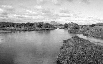
Te Pahitauā, 5 kilometers west of Whakatāne, Bay of Plenty, Aotearoa New Zealand. This view is southeast, PŨtauaki would be visible immediately to the right. With the draining of the Rangitaiki swamp, much of the land around Te Pahitauā is now above water level. This photograph depicts one area that has been restored to its former wetland ecology under an environmental management plan initiated by Ngāti Hikakino. Photograph credit: J. Hōhāpata-Oke, August 2006.

Te Pahitauā is an iwi-identified land and water feature positioned between two raised land areas, Moutohorā a volcanic island 10 kilometers directly north into Te Moananui a Toi,Footnote 2 and PŨtauaki, a land-based volcano 30 kilometers south. The Oriini tributary flowed through Te Pahitauā, linking three major river systems of the Rangitaiki swamp,Footnote 3 hence the recognition of this major waterway as a natural confluence, an innate place to gather and depart. Therefore, it also acted as a natural border connecting people, between different resident and visiting hapŨ, and as a common meeting place between individuals or groups travelling through the area. There are specific places where iwi politics were discussed, actions settled on, and forthcoming consequences were embraced. Te Pahitauā was such a place, where rangatira gathered and set about negotiating whether to act or to defuse a situation.
Today, the two hapŨ Ngāti Hikakino and Ngāi Te Rangihouhiri, and their marae Footnote 4 Puawairua and Rangihouhiri, occupy Te Pahitauā. Ngāti Hikakino are the descendants of the tīpuna (ancestor) Hikakino who through whakapāpā, genealogical recitation, is acknowledged to be 14 generations removed.Footnote 5 The ancestor Irapeke, great grandfather of Hikakino, was such a rangatira, and in oral stories, Te Pahitauā was where after a decision was settled on, Irapeke gathered the ope tauā (war party of warriors) and headed into battle.
TĪPUNA KŌRERO: ANCESTRAL WORDS OF MEANING
E ‘Upe, he aha kore i whakatŨ ai tō whare ki runga i te timutimu, wehewehe whenua, wehewehe tāngata, wehewehe tikanga?
Te Kooti Arikirangi Te Turuki, March 29, 1893
O ‘Upe [Taupe], why have you built your house on the stump, dividing the land, the people and their beliefs?Footnote 6
It is commonly believed by many hapŨ and iwi of Ngāti AwaFootnote 7 that this kupu whakaari (prophetic saying) of Te Kooti was fulfilled when Hoani Taupe Poururu and Hōhāpata Oke moved the whare tīpuna (ancestor house) Puāwairua from Ōtamauru to Te Pahitauā.Footnote 8 Although the displacement of this physical building from its original site to its final residence traversed a distance of only 2 kilometers, much spatial and ideological territory was covered. It was also temporally insignificant that nearly 30 years passed before Puawairua was re-erected and opened on November 8, 1922.Footnote 9 After all, decision-making and sequential actions are not trivial matters, especially when they have repercussions that still are of consequence today.
Landmarks such as Te Pahitauā are pivotal places to consider because they offer an insight to contextualizing many different types of negotiations. Equally, kupu whakaari are vital mnemonic connectors to oral engagements that have occurred among individuals and between hapŨ representatives for millennia. During Te Kooti Arikirangi's lifetime (?–1893), he was to witness and play a major part in one of the most turbulent periods of Māori and Pākehā (non-Māori) engagements in Aotearoa New Zealand. At this time (c1860s), the newly formed colonial government sought to usurp Māori lands from Māori ownership and engaged in military action into iwi and hapŨ territories. Te Kooti, along with many other rangatira and tāngata whenua,Footnote 10 resisted these invasions and through his acts of resistance he was well known in Te Ao Māori and well publicized in the sensationalized media reports of Te Ao Pākehā.Footnote 11
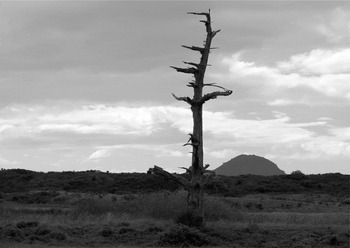
Ōtamauru, 3 kilometers west of Whakatāne, Bay of Plenty, Aotearoa New Zealand. This view is north; in the distance is the volcanic island Moutohorā, also known as Whale Island. Adjacent to the tree in the foreground was the original site of Puawairua marae. Photograph credit: J. Baker, August 2006.

After Te Kooti was officially pardoned (1883) and toward his final years, he travelled extensively throughout the central North Island of Aotearoa New Zealand and spoke many kupu whakaari. These were declared before individuals and hapŨ; but significantly, as indicated by Binney,Footnote 12 they were remembered as critical to the time, landscape, and the people of that place. Over the years there have been different interpretations offered as his words were examined by individual hapŨ regarding their relevance to present or future situations. Essentially, they are now metaphoric connectors binding hapŨ to consider their ongoing affect in all potential negotiations and for an oral culture, fulfilling a vital role as verbal confluences of meaning.
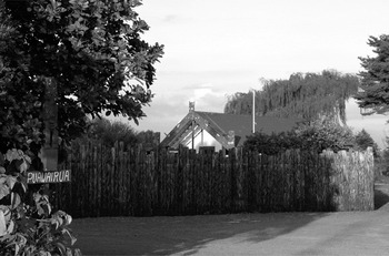
Puawairua marae, 5 kilometers west of Whakatāne, Bay of Plenty, Aotearoa New Zealand. This view is of the entrance facing north. Photograph credit: J. Baker, August 2006. Reproduced with the permission of Ngāti Hikakino and the Puawairua Marae Committee.

Although landscapes have changed, the words of our tīpuna have often remained within our oral sources, and they continue to play a role in hapŨ life. When history is recalled and in a sense the past is captured, other associated knowledge is evoked and proclaimed before a contemporary audience. History, in particular tīpuna kōrero, the words of ancestors and their deeds, are not entirely confined to written sources but their efficacy is truly enacted when spoken on the marae, as the most appropriate place to express ritual exchanges.Footnote 13
To relate history in an oral format and interweave connections of place, time, events, tīpuna kōrero, and taonga Footnote 14 expresses the ability to contextualize a chosen situation and give heightened authority to a particular interpretation. In relating tīpuna kōrero, the words themselves become the negotiated element; they configure whether or not an ideological border is to be traversed. How a marae-based audience receives this is often not a passive affair and it may be challenged or be sanctioned. Marae are places where convergences of ideas are central to the construction and affirmation of social selves, a hapŨ or common community identity, and perhaps a consensual position reached on an issue. In moving the marae of Ngāti Hikakino to Te Pahitauā and with occupation of this site, the welfare of the hapŨ improved and of course, a prophecy was fulfilled.
In his later years, Te Kooti travelled extensively throughout the east and central North Island, often with a group of followers of the RingatŨ faith, visiting marae, and rangatira. An important function of these journeys was to reconcile his previous actions; carry the word of Te Rongopai, Eternal Peace; and because he was considered a prophet, to speak on matters of hapŨ importance. In 1884 Te Kooti composed 14 waiata (songs) and spoke several kupu whakaari to denote a number of occasions, including opening the whare tīpuna Eripitana at Te Whaiti on January 1Footnote 15 and his stay in the whare tīpuna Ruataupare at Te Teko sometime around January 10. Te Teko is less than 30 kilometers south of Te Pahitauā and was also a well-known place of convergence because it is located along the banks of the Rangitaiki River.Footnote 16 It was also the last standing ground of the Ngāi Te Rangihouhiri rangatira Te Hura Te Taiwhakaripi in the siege of Te Kupenga, ordered by Governor Grey and undertaken by military forces led by William Gilbert Mair (1832–1912), the elder brother of Gilbert Mair (1843–1923) in 1865. According to Binney,Footnote 17 sometime between January 10 and 12, 1884, Te Kooti was near Whakatāne, and this is the most likely place and time in which the taonga Te Maungarongo (The Peacemaker)Footnote 18 was gifted to Wiremu Kingi Te Kawau.Footnote 19
Te Kupenga, Te Teko, 35 kilometers southwest of Whakatāne, Bay of Plenty, Aotearoa New Zealand. This view is south with PŨtauaki in the distance (also known as Mount Edgecumbe). The Rangitaiki River is immediately to the left of this view and Ruataupare marae is 2 kilometers north. Photograph credit: J. Baker, August 2006.

TUKU TAONGA: GIFTS OF MEANING
During the New Zealand Wars (1843–1881)Footnote 20 Wiremu Kingi and Te Kooti were on opposite sides of the conflict. Kingi, rangatira of the iwi Ngāi Tai and who had rallied together a fighting force in support of the CrownFootnote 21 was in May 1869 under the command of Major William Mair.Footnote 22 The ensuing campaign to apprehend Te Kooti and te whakarau (the exiles) redefined traditional roles of leadership, and allegiances to Pākehā were established that were of consequence during and after the wars. Battles once fought on the same lands that Te Kooti now travelled carrying the banner of peace were still navigated by former opponents. However, this time convergences were occurring for different reasons.
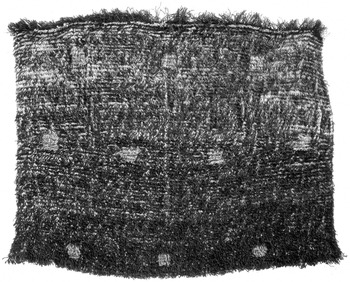
Although Wiremu Kingi did not support the religion Te Kooti espoused, it seems some commitments were established. As Binney continues, “these two former enemies exchanged speeches in which both upheld the principle of working within the law and under its protection.”Footnote 23 Following such speeches and in alignment with tikanga (cultural protocols), it is not surprising, then, that the gift of Te Maungarongo would seal some sort of unified agenda between these two men. It is even more of an indication of Te Kooti's frame of mind in that when he met Gilbert Mair, perhaps no more than a day later on January 12, 1884, he also gifted a kinikini (a woven cloak with black twisted thrums) by placing it on Mair's shoulders and stating, “Even though this mat be too small to cover you, my love enriches your body from head to foot.”Footnote 24 Although two very different types of taonga were gifted to former enemies, Te Maungarongo and the kinikini at one time may have resided together in Tamaki Paenga Hira Auckland War Memorial Museum.Footnote 25
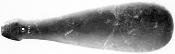
Te Maungarongo, AM 331. Photograph credit: Krzysztof Pfeiffer, 2006, Tamaki Paenga Hira, Auckland War Memorial Museum.

Sometimes, on marae and other designated places, taonga have a crucial role to play in the unfolding of negotiations, in guiding action or reaction. In particular, a tuku taonga, a prestation (ceremonial presentation) from one party to another or an exchange of taonga, repositions both parties relationship. Through tīpuna association and whakapāpā (genealogy) the merit of a taonga is conferredFootnote 26 and some are invested with a role as a border negotiator, moving from one context of possession to another. A tuku taonga or tuku rangatira is a representative of the ability of a rangatira to express the wealth of a hapŨ and convey their esteem to the recipient.Footnote 27 Place, occasion, and people are all significant factors. the first, as already mentioned, establishes geographical and ideological convergences; the second denotes the reason for such a gathering in consideration of potential actions and consequences; and the third are those who will carry the kōrero, the oral dissemination when the next time this event is discussed and continually reassessed. There are numerous examples in Māori oral and recent written history of tuku taonga between rangatira that solidified relations and connected once diverse agendas.
LAND COURTS: JUDICIAL NEGOTIATORS
Native Land Courts were established immediately following large land confiscations to administer land transfers in the distribution of the spoils of the New Zealand War. Iwi and hapŨ throughout the country were forced to engage with judiciaries to attempt to seek redress for land invasions and, if possible, compensation for land loss. However, two very different philosophies regarding land were now converging. For the Crown, the Native Land Court was the legal mechanism to initially transfer confiscated land to property law and later to process untitled land (common or reserve lands). However, in general for Māori, dealings with the Native Land Court meant conferring their access rights as guaranteed under the Treaty of Waitangi (1840) and through tīpuna and whakapāpā association.Footnote 28 However philosophically fraught the establishing of legal title, it was further complicated by the self-assumed role of the court in assessing the validity of differing land claims, particularly where physical borders between iwi and hapŨ were in dispute. Sometimes this would mean visiting land blocks in questionFootnote 29; but because these major decisions were often made not on the land but in a court of law, rangatira frequently enacted traditional imperatives to seal these pacts.Footnote 30
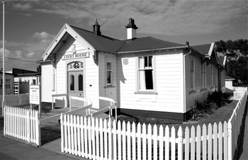
Opotiki courthouse on the corner of Church and Elliott Streets, Opotiki, 25 kilometers east of Whakatāne. The original 1870s building was replaced by this one on the same site in 1910. Photograph credit: Krzysztof Pfeiffer, December 2006.

A year after Te Maungarongo was gifted (1884), it was possible to explicate the situation and place in which C. Alma Baker perhaps received this taonga. Born in 1857 and raised in Otago, Charles Alma Baker trained as a surveyorFootnote 31 and was a member of the Wellington Philosophical Society at least from 1878 to 1884. In 1885 William Mair was in Opotiki as presiding judge for hearings regarding land allocations of the Eastern Bay of Plenty and on January 20 the case for the land block Tunapahore began. Ngāi Tai claimants were represented by Wiremu Kingi and Te Whānau a Apanui counter-claimants were represented by Te Hata Te Kakatuamaro and other rangatira. An entry in William Mair's diary for January 22, 1885 noted, “Alma Baker here.”Footnote 32 It is possible that this was the situation where Te Maungarongo passed from Wiremu Kingi to Alma Baker, through William Mair, whereas it is also possible that this was a direct gift because all three men were in the vicinity at the same time.
As negotiators, judges and court interpreters mitigated the Crown's legal system, ensuring that the border between enforcing the law and restraining iwi was controlled. In examining cases of individual taonga that are noted to have been presented at Native Land Court proceedings,Footnote 33 this intermediary role also proved beneficial in collecting taonga, and it was one which William Mair was already familiar.Footnote 34Tuku taonga—the presentation of a taonga—solidified the perspective presented by a rangatira; and while in court, the presence of a taonga associated with tīpuna activities on this land, confirmed this association. In consulting the volumes of books from Native Land Courts (commonly referred to as the Land Court Minutes), scribes, interpreters, and judges diligently transcribed all oral information presented in the courts. Much of this written material recorded tīpuna kōrero, whakapāpā, and waiata, and further demonstrates that for Māori the spoken word is pivotal in conferring relationships.
Taonga presented in Native Land Court situations were and still are material representations of these arrangements. The removal of taonga from the negotiating space of iwi into Crown ownership and therefore private property law was a transfer of more than just a physical object. The efficacy of a taonga to initiate a negotiable situation was guaranteed through tīpuna association, whakapāpā, and kōrero; however, in non-Māori situations there was little or no onus on the recipient to retain this associated information. Therefore, embedded knowledge of place and time was often considered insignificant by Pākehā, whereas it is also possible to speculate that it was prudent for court officials to obfuscate received objects,Footnote 35 especially if there was already an intention to build a collection of taonga.Footnote 36 In this case, it is fortunate that Te Maungarongo did retain its taonga name and a connection to one person, Wiremu Kingi.
Te kinikini o Te Kooti, AM 828. Photograph credit: Krzysztof Pfeiffer, 2004, Tamaki Paenga Hira, Auckland War Memorial Museum.

INSTITUTIONALIZATION: MUSEUM CONVERGENCES
As noted by Tapsell,Footnote 37 Gilbert Mair, in relation to the taonga he collected, often retained narratives and associated kōrero, including whakapāpā. In letters to Thomas Cheeseman and Augustus Hamilton,Footnote 38 Mair sometimes recorded in-depth information about individual taonga and conveyed to James Cowan stories of his adventures as a soldier and government interpreter among iwi of the central North Island.Footnote 39 During the New Zealand War period and later (as the colonial government consolidated policy), Mair and many of his contemporaries were involved in a unique industry. As civil servants they negotiated the border between government agendas (including continuing the process of annexing iwi-occupied lands) and mitigating the competing imperatives of rangatira, and mediating between Pākehā and Māori whose borders were still geographically defined. They were appointed often because of their fluency in te reo Māori (the Māori language); therefore the ability to engage within tikanga Māori (Māori cultural protocols) as orators in the field negotiating between both worlds. This also provided the opportunity to gather taonga and in examining early Auckland Museum records, many of the collectors of Māori material culture were, in various capacities, civil servants. Gilbert Mair's predisposition for collecting and his government career of more than 50 years in the field, culminated in an “unrivalled collection of Māori curios.”Footnote 40 The accession record for Te Maungarongo, held in the Ethnology Department of the Auckland Museum, states that C. Alma Baker sold it to the Auckland Museum in 1890, the same year Gilbert Mair deposited the bulk of his collection.Footnote 41
In relation to the gift of the kinikini to Gilbert Mair, this exchange occurred in Matatā, 25 kilometers due west of Te Pahitauā, when Te Kooti was travelling further west to MaketŨ. CowanFootnote 42 provides another version of Te Kooti's words, “Wear this korowai in memory of me, and if it be not large enough to cover you, let me clothe you with my love.”Footnote 43 In analysis of the writings of Gilbert Mair for other taonga, of which he provides narratives written in te reo Māori and translations to the English language,Footnote 44 and because of the allegorical nature of both statements, it is most likely these words were spoken in te reo Māori. It is also likely the kinikini would have continued to remain silent, as it already had for more than a hundred years in the Auckland Museum,Footnote 45 except for the intervention of the Ko Tawa Project.Footnote 46 Within an institution it would have continued to denote object passivity, with its wider association to tīpuna kōrero and history, to tīpuna and personages, only referenced in diverse sources and disconnected from a contemporary audience.
The Tarawera River at the point it forks left and right, 25 kilometers west of Whakatāne, Bay of Plenty, Aotearoa New Zealand. This view is south, the central landmass in the middle was once an island and a settlement known as Te Kohika. Directly behind and further in the distance is PŨtauaki. Photograph credit: J. Baker, August 2006.

Hirini MeadFootnote 47 explains that the significance of a taonga is inscribed through its connection to whakapāpā, yet one aspect not apparent in this research is the whakapāpā of either taonga. That is, neither Te Maungarongo nor the kinikini are named for a tīpuna; therefore, there is no direct physical link with a hapŨ or marae. It is tīpuna association that is elucidated. However, in the larger story of the Mair Collection, other taonga are individually situated with their whakapāpā.
In 2005 Paul Tapsell, Director Māori of the Auckland Museum, instigated offsite research of the Mair Collection, travelling to hapŨ and iwi landscapes.Footnote 48 The Ko Tawa Project Team visited many locations and recorded numerous conversations with rangatira and others in the field, intent on investigatory research of individual taonga. Their expedition into the vicinity of Te Pahitauā was particularly poignant because descendants of Gilbert Mair from his relationship with Anahera Te Poono still reside here, alongside the descendants of William Mair and Raiha Apanui; and both families are entwined in the contemporary life of Puawairua marae. An outcome of the Ko Tawa Project Team's visit was the recalling of this whakapāpā; and in examining the antics of Gilbert Mair, dissimilar perspectives from Mair's public profile were raised.Footnote 49
HAPŪ CONSOLIDATION
In August 2006 at Puawairua, our hapŨ organized a series of wānanga (marae-based learning) focusing on historical research and hapŨ development in which, among other things, there was much discussion on what taonga are collectively retained. Along with other hapŨ and iwi of Ngāti Awa, Ngāti Hikakino and Ngāi Te Rangihouhiri were bereft of their rangatira and their material culture during the invasion into iwi lands in 1865, the force being led by William Mair. An example of this is the following, but the whereabouts of these taonga has yet to be ascertained:
Huia feathers. Taken from the heads of two rebel chiefs, Te Hura Te Tai and Horamana [sic], a native prophet, who planned the murder of James Fulloon. Both were sentenced to death, but the sentence was carried out in the case of the later only, Te Hura being liberated after some years of imprisonment. Captured by Major Mair in Te Teko pa, November, 1866 [sic, September 1865].Footnote 50
One aspect of the wānanga was a hīkoi (march) throughout the Rangitaiki area covering many of the landscapes mentioned in this article, including all three rivers, Ohinemataroa, Rangitaiki, and Tarawera as well as the Oriini and Te Awa o te Atua confluences. We travelled on confiscated lands now in private ownership, retraced the journeys of Te Kooti and in particular recollected his kupu whakaari, and listened intently as our rangatira expounded interpretations of history not captured in books or journal articles. Both taonga Te Maungarongo and the kinikini were directly referred to, and many more which continue to reside outside of our kaitīakitanga (guardianship). And, before their descendants who are among us, both William and Gilbert Mair were referred to, specifically in reference to their exploits on our landscapes that disempowered our tino rangatiratanga (self-determination). For me there is no better way to understand the enmeshed nature of relationships between: place, oral and written histories, genealogical connections and taonga. It is also preferable that this is explicated on the landscape from which actors (the border negotiators) and actions (the negotiations) transpired, because it is here that the entangled nature of these interconnections are captured, albeit reinterpreted before a contemporary office.
Ko tō mātou whakapāpā ko ō mātou taonga, ka tŨhonohono i tō mātou hapŨ, ā, ki te mātauranga hoki o tō mātou hapŨ nā reira te mahi a ō mātou tīpuna i te whenua tipu.
Genealogy and taonga link us to our hapŨ and our hapŨ-based knowledge related to the lives of our ancestors upon ancestral landscapes.
Rangihoea Ratahi, Ngāti Hikakino & Ngāi Te Rangihouhiri kuia (elder), January 2008.
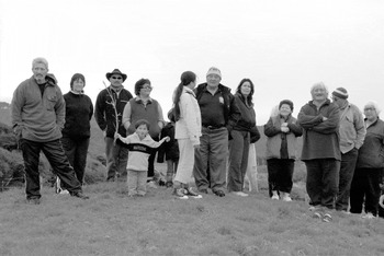
Ngāti Hikakino and Ngāi Te Rangihouhiri hapŨ standing on a raised knoll beside the Tarawera River, 25 kilometers west of Whakatāne, Bay of Plenty, Aotearoa New Zealand. Photograph caption: J. Baker, August 2006.

In investigating taonga we are reminded of the agenda of rangatira, acts of conflict and struggle, voices of dissonance, and unity and of hapŨ survival and reformation. It is precisely because of the act of disconnection, which has determined the fate of many taonga in local and international museums, that taonga passivity must be redressed. This disparity will continue to rule the fate of displaced objects, as demonstrated for Te Maungarongo and the kinikini, until rekindled or new connections are forged. For iwi and hapŨ there is more at stake than just the return of an object, because research and associated knowledge reinvests taonga back into physical and cultural landscapes. Museum collections are a pivotal intersection because they are significant repositories of iwi and hapŨ knowledge. For our hapŨ it is not totally up to museums to undertake research in our community, nor is it entirely appropriate; but it is now up to us to follow the path of taonga that have left our landscapes.Footnote 51 To enact an age-old tradition of renegotiating the borders of intellectual and cultural propertyFootnote 52 and understand that ancestor efficacy will truly be enacted through us, the next generation of border negotiators, as we prepare to take the challenge of continuing the kōrero.