The purpose of this paper is to put to the test the hypothesis that the regional, civic/ceremonial center of Coba, located in the state of Quintana Roo, Mexico, exhibits a general concentric settlement pattern organized with the greater part of its major civic, ceremonial, and habitational architecture clustered closest to the urban center or the downtown area. This contrasts with Arnold and Ford's (Reference Arnold and Ford1980) conclusions based on their findings at Tikal, Guatemala, that suggested a dispersed rather than a concentric pattern for urban centers in the Maya area.
We correlated the most useful trees of the prehistoric, historic, and modern Maya with their cultural environment finding that trees such as pom (incense) and balche (a sacred intoxicating drink) trees are found in greater concentrations closest to the Classic period (a.d. 600–950) city's urban center or downtown area than in the suburban and peripheral areas.
More than 25 years ago, we hypothesized that Coba ceased to be a major center concurrent with shifting climatic conditions that brought about a reduction in rainfall ca. a.d. 800 (Folan et al. Reference Folan, Kintz and Fletcher1983; Gunn and Folan Reference Gunn and Folan1996), which was later confirmed by Leyden, Brenner, and Dahlin's (Reference Leyden, Brenner and Dahlin1998) pollen analysis of cores from Lake Coba.
Even though the ancient Maya were geographically separated from the organizational wonders of central Mexico, they had developed many of the sociocultural and economic advances within that sphere of influence since the Middle Preclassic period (650–350 b.c.), long before Teotihuacan appeared on the horizon (Folan et al. Reference Folan, López, Heredia, Folan and Domínguez Carrasco2001), at sites such as Nakbe, Guatemala, which has been under investigation by Richard Hansen (Reference Hansen1991). According to Sanders and Price (Reference Sanders and Price1968), one of the perceived differences between the Lowland and Highland Maya and the Mexican Highlands was the apparent lack of cities and urban centers. Mapping projects at Tikal (Carr and Hazzard Reference Carr and Hazzard1961; Puleston Reference Puleston1973, Reference Puleston1983), Dzibilchaltun, Yucatan, Mexico (Andrews IV and Andrews V Reference Andrews and Andrews1980; Kurjack Reference Kurjack1974; Stuart et al. Reference Stuart, Scheffler, Kurjack and Cottier1979), Coba (Folan et al. Reference Folan, Kintz and Fletcher1983), and Calakmul, Campeche, Mexico (Folan et al. Reference Folan, López, Heredia, Folan and Domínguez Carrasco2001) brought about appreciable shifts in earlier visions of Maya sociopolitical organization and settlement patterns in general. We can now state that the Maya developed large urban cities of 20,000 or more inhabitants that functioned as regional centers of large polities such as those found at Coba and Calakmul. Although most scholars would now go along with these ideas, whether or not these centers were organized concentrically has been brought into focus by an analysis of the archeological map of Tikal by Arnold and Ford (Reference Arnold and Ford1980) who also expressed doubts as to whether Coba was so organized, based on our independent findings (Folan et al. Reference Folan, Kintz and Fletcher1983). In this paper, we have set out to demonstrate that Coba was not only a city and urban center but was also organized in a general concentric pattern. Although we argued that this was the case previously, we can now demonstrate this based on more sophisticated statistical analyses than were available to us at that time. In addition, we can expand the analysis to include for the first time, the architectural content of Zone XIII mapped by Jacinto May Hau and Nicolas Caamal Canche in 1976.
COBA: THE CITY
Coba represents one of several major urban centers dating to the Classic Maya period. Archaeological investigations at this center have identified a complex socioeconomic and political integration apparent in the heterogeneity of size, shape, and quality of architecture while also showing a clear demarcation between commoner and elite compounds. The metropolis of Coba included its 63 km2 central place in the northeastern area of the Peninsula of Yucatan, and there is evidence of occupation extending back to Preclassic period times (Con Uribe Reference Con Uribe, Shaw and Mathews2005). Along with Merida (Ich Caan Ziho), Izamal (Itzam Na), and Uxmal, Coba represents one of the largest cities on the northern peninsula and the rest of the Maya area. Its Ixmoja temple is the highest surviving structure in the northern lowlands. The size of Coba is matched by its large population. Using a variety of methods, including those of Casselberry (Reference Casselberry1974), Haviland (Reference Haviland1968), Naroll (Reference Naroll1962), and Puleston (Reference Puleston1973), as well as studies in the modern village of Coba, controlling for noncontemporaneous occupation, and applying various reductions based on structure counts, we suggest that conservative figures of between approximately 20,000 and 60,000 be considered a realistic range for the Coba population during the Late Classic period (a.d. 600–850) (Folan Reference Folan1975; Folan et al. Reference Folan, Kintz and Fletcher1983:191–210). The areas of all zones (Figure 1) surveyed at Coba are noted (Folan et al. Reference Folan, Kintz and Fletcher1983:Fig. 1.3; Kintz and Fletcher Reference Kintz, Fletcher, Folan, Kintz and Fletcher1983:Table 13.1). In addition, the population was estimated from calculating roofed-over space in the 13 survey zones containing more than 6,000 structures (Kintz and Fletcher Reference Kintz, Fletcher, Folan, Kintz and Fletcher1983:Table 13.2) with the exclusion of platforms with no visible superstructure (Kintz and Fletcher Reference Kintz, Fletcher, Folan, Kintz and Fletcher1983:Table 13.3). The population was also calculated by counting the number of structures per household unit and total square meters of roofed over space in Zones I and V (Kintz and Fletcher Reference Kintz, Fletcher, Folan, Kintz and Fletcher1983:Table 13.5). Finally, analysis of the number of structures per household unit and total square meters of roofed over space, excluding any kitchens and storehouses was completed to calculate the total population living in the city (Kintz and Fletcher Reference Kintz, Fletcher, Folan, Kintz and Fletcher1983:Table 13.6). In comparison with the population of 10 sites listed by Sharer (Reference Sharer1994:Table 10.3), Coba would clearly rank with Tikal as a Maya mega-center based on population. Population size for Copan, western Honduras, including the rural zone, is quite low. The population estimate for Calakmul is 20,000 inhabitants based on a 55% rate of the contemporary occupation of 6,250 structures (Fletcher and Gann Reference Fletcher, Gann and Folan1994). These high population estimates support and reflect the complexity of socioeconomic and political organization at Coba.
The sacbeob of Coba, Quintana Roo plotted in by George E. Stuart (in Folan Reference Folan1975, Folan et al. Reference Folan, Kintz and Fletcher1983:Figures 1.2 and 1.3). The sacbe pattern emanating from the central core area toward the outer limits of the urban area strongly suggests a concentric settlement pattern unlike the sacbe pattern at Tikal (Carr and Hazzard Reference Carr and Hazzard1961). The sacbeob are identified by Arabic numbers and the zones surveyed by Roman numerals.

Coba's Sacbe 1 extends 99 km out from the center of the city providing a powerful reminder of its socioeconomic and political capabilities, thus confirming the impression that Coba was a significant social, economic, and political hub. Other nearby centers, such as Ixil and Yaxuna, connected to Coba by sacbeob, operated as satellites, thus providing a vivid image of Coba's hegemonic prominence. The funnel-shaped sacbe pattern emanating from the center toward the outer limits of the urban area strongly suggests a concentric pattern in contrast to Tikal. Coba is also tied to a series of mythological sacbeob extending to Valladolid (Zac Ii) and from there to Chichen Itza, Merida (Ich Caan Ziho), Uxmal, and finally Mexico. These ancient roads convey and document the idea that all was within the grasp of the rulers of this ancient city. Following Trombold (Reference Trombold and Trombold1991), the formal road systems collapsed both physical and symbolic space. Although Coba is associated with a complex system of roads, it is less well known that some of the roads were mythological projections. They consisted of celestial skyways (cuxan sum), including, for example, one between Dzibilchaltun and Izamal that, in several cases, extended for great distances at times representing blood-filled umbilical cords, thus suggesting sanguineal ties (Miller Reference Miller1982). These differ from the underground roadways connecting, for example, the ruins of Acanmul, Campeche, and Uxmal, Yucatan (Bolles and Folan Reference Bolles and Folan2001).
The proliferation and variation among elite, middle class, and commoner dwellings at Coba, the immense size of the settlement, the heavy labor investment in the construction of palaces, temples, ball courts, and the extensive road system reflect the complex nature of the social, economic, and political organization at the center. Geographic information systems (GIS) offer a more exact reflection of the spatial data in the archaeological ruins while also providing a more refined test of the presence of a concentric pattern of high-status architecture at Coba, as well as a test of population and residential differentiation from core to periphery.
SOCIAL ORGANIZATION OF COBA
The population of Coba was divided into different categories of elite, middle, and commoner classes distributed in neighborhoods and barrios active in various forms of specialization, similar to the social organization discussed by Landa's (Reference Landa and Tozzer1941) concentric model that described sixteenth-century Maya towns as centered around temples with priests, nobles with the wealthy residing nearby, and the lower class members living on the periphery. In addition, it has been hypothesized that pre-Hispanic Maya urban settlement patterns can represent a mosaic pattern of household clusters, representing small, coordinated, neighborhood divisions located within and crosscutting concentric zones (Arnold and Ford Reference Arnold and Ford1980; see Bullard Reference Bullard1960; Fletcher et al. Reference Fletcher, Folan, May Hau, Folan, Folan, Fletcher, May Hau and Folan2001; Puleston Reference Puleston1973). Evidence suggests that Coba was organized into units occupied by extended family groups resembling corporate, lineage households as in the case of Dzibilchaltun (Folan Reference Folan1969, Kintz Reference Kintz, Folan, Kintz and Fletcher1983b:Figure 12.1). Polygamy and status may help to explain the size and disposition of different households (Kintz Reference Kintz, Folan, Kintz and Fletcher1983b:Table 12.2).
To determine whether there existed a significant difference in household status at Coba, we used the available data from our archaeological survey: the distance from the urban center or downtown area of the site; the size of the basal platform; the height of the basal platform; the number and size of the superstructures as well as the presence or absence of high-status vaulted superstructures. In addition, we also noted the presence or absence of house lot walls, the size of the area, or solar, enclosed by these walls and the number and size of the ancillary structures associated with the main platform (Fletcher Reference Fletcher, Folan, Kintz and Fletcher1983; Fletcher and Kintz Reference Fletcher, Kintz, Folan, Kintz and Fletcher1983). These were often enclosed within the house lot walls but built directly on bedrock. When there were no existing house lot walls to denote a formal solar, we could determine associated structures by their proximity to the principal basal platform. These were frequently fairly small and included round or apsidal structures, which we suggested might have functioned as a kitchen, as well as additional round, apsidal, and rectangular structures, whose possible functions have been discussed in our original publication (Folan et al. Reference Folan, Kintz and Fletcher1983).
Our analysis showed that the largest and highest basal platforms and those with the most superstructures and the highest frequency of vaulted buildings were closest to the urban center. The area encompassed by the house lot walls was also significantly larger than household platform units in more distant areas. Thus, there was a significant correlation between house lot size, basal platform, number, size, and type of superstructure location and solar size, allowing us to suggest the existence of a range of economic statuses between elite, middle range, and commoner status.
There also are patterns resembling a mosaic within the aforementioned concentric pattern wherein large hypothesized residential units were also associated with hypothesized commoner dwellings. This would support the thesis suggested by McAnany (Reference McAnany1995) that an alpha household or residence of an elite household would include commoners who had attached themselves to the elite family for obvious economic advantages.
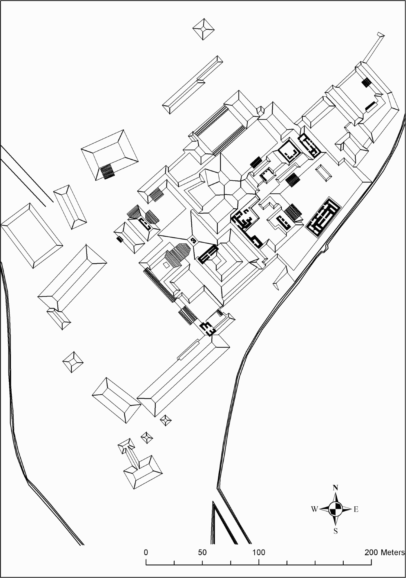
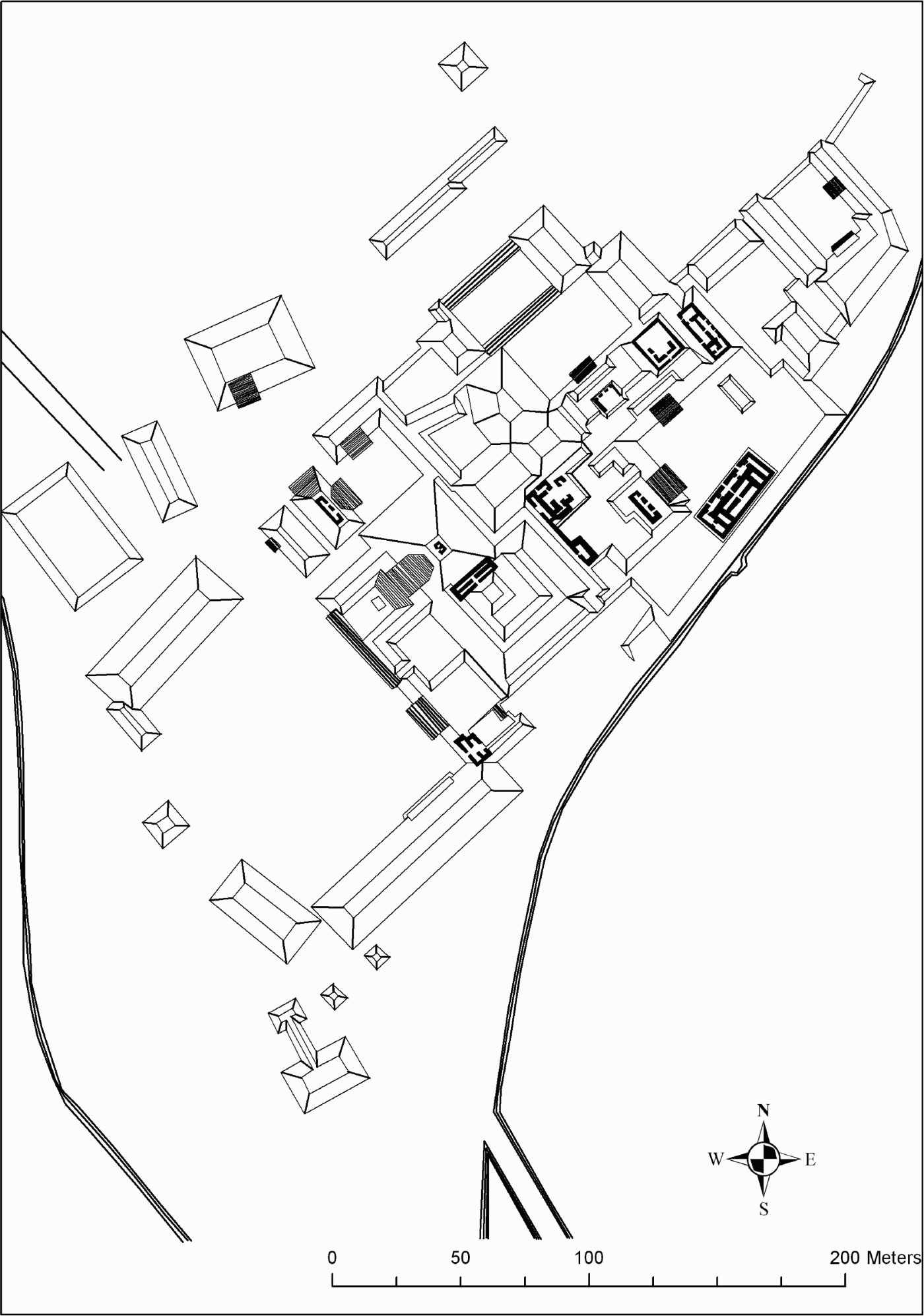
In Coba, the extreme complexity of the architecture associated with the Coba Group B (Navarrete et al. Reference Navarrete, Con Uribe and Martínez Muriel1979) (Figure 2) associated with Lakes Coba and Macanxoc (from whose waters a mythological market appears every New Years after dark [Folan et al. Reference Folan, Stuart, Folan, Fletcher and Kintz1983]) reflects the essence of a royal court of a high-ranking family. The Coba Group B, with the major presence of high-status, civic/ceremonial, and residential architecture such as a palace, includes expansive plazas, large, elevated vaulted structures; multiple compounds including vaulted elite architecture as well as protected or confined plazas; elaborate staircases, including a hieroglyphic staircase; two formal ball courts with viewing stands; carved and perhaps uncarved stelae; and the termini of several internal, raised sacbeob (roads), extending to the north and south; as well as nearby connections to roads extending east and west. These features are tightly integrated into a complex socioeconomic and political sector exhibiting the heterogeneity of the size, shape, and quality of architecture associated with the noblest and wealthiest residents as suggested by Diego de Landa (1941) for Maya settlements in the sixteenth century. Likewise, settlement patterns associated with the more elaborate sacbe termini surrounding the core suggest occupation by high-ranking batabo'ob (town governors) and their immediate family members.
Coba Group B, after Navarrete et al. (Reference Navarrete, Con Uribe and Martínez Muriel1979) based on Thompson et al. (Reference Thompson, Sydney, Pollock and Charlot1932).
High-ranked elite units were identified as the residential Zone I to the north of Lake Coba mapped at different times by Fletcher, Kintz, May Hau, Caamal Canche, Florey Folan, and Folan (Folan et al. Reference Folan, Kintz and Fletcher1983). One high-ranking household unit included a large, raised platform with four vaulted buildings and cenote without an encircling albarrada (a low, dry, stone wall) (Fletcher Reference Fletcher, Folan, Kintz and Fletcher1983; Kintz Reference Kintz, Folan, Kintz and Fletcher1983a:Figure 11:1). Another high-status elite household featured three vaulted and four rectangular structures in addition to four apsidal buildings, a small reservoir, and an extensive use of albarradas. This compound was situated next to Sacbe 3 (Kintz Reference Kintz, Folan, Kintz and Fletcher1983a:Figure 11:2).
Among the middle class households, one featured three platforms with two vaulted structures and seven apsidal buildings plus an extensive albarrada system (Kintz Reference Kintz, Folan, Kintz and Fletcher1983a:11.3). Albarradas denoted territoriality as well as soil, water, and wind control. Other middle status households included albarradas and a single masonry, vaulted building (Fletcher Reference Fletcher, Folan, Kintz and Fletcher1983; Kintz Reference Kintz, Folan, Kintz and Fletcher1983a:Figures 11.3, 11.4, and 11.5), and other configurations. A smaller, commoner household on a raised platform without an albarrada was further to the north (Kintz Reference Kintz, Folan, Kintz and Fletcher1983a:Figure 11.12). Single or double structure households without platforms or albarradas were also mapped.
The higher status households were usually closer to the urban center and, in some cases, adjacent to a sacbe. They, as well as religious structures, were not usually delimited by albarradas. Kintz (Reference Kintz, Folan, Kintz and Fletcher1983b:Figure 12.1) presented a model showing the spatial relationship between households in the Northern Zone I of Coba, connecting all of those within 70 m of each other. She documented 35 clusters including eight elite and 27 commoner compounds (Kintz Reference Kintz, Folan, Kintz and Fletcher1983b:Table 12.2). All eight elite compounds are situated south of the San Pedro complex at the northern terminus of Sacbe 3, some 3 km to the north of Coba Group B. On the other hand, all but two of the 27 commoner compounds are situated to the north of this complex. Kintz also observed that elite compounds are either isolated or associated with commoner household units. Partially isolated units including high-status, vaulted architecture probably served intrabarrio religious or political activities (Folan Reference Folan1975). Kintz argued that those elite units associated with commoner dwellings were foci for the control of barrios (neighborhood wards). The commoner households in these units were related to elite families by kinship links. Concurring with an argument put forth by McAnany (Reference McAnany1995), it is, therefore, hypothesized that these neighborhood units represent extended family groups exercising political, social, and economic functions in Coba as corporate households related through kinship or affinity, a spatial reflection of Classic period Maya socioeconomic and political organization.
Another look at the Northern Zone I at Coba shows a pattern of continuous neighborhoods or barrios with elite residential compounds as nodal points, all within the framework of a generally concentric pattern while also defining neighborhood complexity with large and small barrios or wards (Kintz Reference Kintz, Folan, Kintz and Fletcher1983b). The segregation or grouping of clusters of residential units frees space between those neighborhoods. Thus, the spatial configuration of neighborhoods may reflect a “garden city” with open areas that could be used for arboricultural and horticultural zones in the “in between” or chum uk' luum zones described by Folan et al. (Reference Folan, Kintz and Fletcher1983) and Tourtellot (Reference Tourtellot, Sabloff and Henderson1993). Ancillary features associated with households include stone-enclosed, raised-bed garden plots and adjacent charcos (small seasonal ponds), further documenting household variability and the complexity of Maya socioeconomic organization.
The cacao tree reported (Folan et al. Reference Folan, Kintz and Fletcher1983) is still visible in the ko'opiox. The removal of detritus from the bottom and sides of this ko'op, ostensibly by the ejido that maintains it, has revealed structural formations including what appears to be stairs associated with the lower part of this natural feature in addition to the remains of a low platform at its upper edge. The subject tree identified by our two Coba colleagues is shaded by ramon trees (Brosimum alicastrum).
In 1989, Sanders formulated four major organizational tenets of the Late Classic period Copan Dynasty (Fash et al. Reference Fash, Andrews, Manahan, Demarest, Rice and Rice2004). Combining his classification with our earlier investigations (Folan et al. Reference Folan, Kintz and Fletcher1983), we find that the ruler and the royal house (Anaya Hernandez Reference Anaya Hernández1994; Gillespie Reference Gillespie2000) may have housed several thousand people as economic and political dependents, many of whom may have resided in and around Group B (Figure 2) in Coba. These are followed by the heads of maximal houses that formed a noble class and provided leadership in a number of separate but closely integrated spheres of activities including economics, politics, religion, and the military. We argue that the people inhabiting the most complex residences in Coba; in places such as Cola de Venado and Utizil Mul to the north of Group B, as well as those living in the most elaborate sacbe termini were those engaged in important economic and political activities. Other examples of extended households include middle ranked but more modest house compounds with vaulted architecture and extensive albarrada systems.
According to Fletcher (Reference Fletcher, Folan, Kintz and Fletcher1983), archaeological, ethnohistoric, and ethnographic data all support the importance of the multiple family household of various nuclear families united by kinship and affinity but without a well-defined unilineal pattern. Once more, in accordance with Levi-Strauss's concept of house, we concur with Benavides Castillo's and Manzanilla's (Reference Benavides Castillo, Manzanilla, Andrews and Gendrop1985) observations at Coba, and McAnany's (Reference McAnany, Sabloff and Henderson1993), Sander's (Reference Sanders and Webster1989), and Webster's (Reference Webster1989) observations at Copan that not only were neighborhoods heterogeneous, but that the residential compounds also contained a mixture of varying economic statuses. This is especially true of the large, Type 4 compounds as defined at Copan such as the House of the Bacabs and several others in Calakmul and Coba as defined by us (Fletcher et al. Reference Fletcher, Folan, May Hau, Folan, Folan, Fletcher, May Hau and Folan2001; Folan et al. Reference Folan, Kintz and Fletcher1983). This, however, does not preclude a general concentric settlement pattern as is evident in the following discussion.
THE CONCENTRIC MODEL REVISITED
Arnold and Ford (Reference Arnold and Ford1980) published a paper on the settlement pattern of the ruins of Tikal, Guatemala, using as their source the 9-km2 portion of the Tikal map contiguous to the core area. Based on their calculations that included labor investments for the vaulted buildings identified by them, Tikal did not possess a concentric settlement pattern as claimed for Coba but a scattering of high-status architecture throughout the 9 km2 central area of Tikal not including the core.
In this work, Arnold and Ford featured the differences between their and our findings at Coba. In 1982, Folan et al. drafted a reply to Arnold and Ford's (Reference Arnold and Ford1980) article that included some questions about their database extracted from the University of Pennsylvania's Tikal map. Ford and Arnold replied to that response in a second article (Ford and Arnold Reference Ford and Arnold1982) and retained their original conclusions.
Given the passage of time and recent availability of hitherto unpublished data on Zone XIII of Coba mapped by Jacinto May Hau and Nicolas Caamal Canche in 1976 under Folan's direction, we have been able to come up with a more detailed analysis of Coba's settlement pattern. Likewise, our analysis of the distribution of useful fruit, fiber, bark, or resin trees registered in Coba in Zones I and III in 1976 by Jacinto May Hau and Nicolas Caamal Canche, who identified and plotted the location of 3,579 useful trees based on their distance from the site center (Folan Reference Folan1977; Folan et al. Reference Folan, Fletcher and Kintz1979), lends strong support to our earlier concentric model. The distribution of the high-status trees reflects the distribution of elite and commoner households based on the presence or absence of vaulted architecture from the core area to the periphery of the site and within barrios or wards from core to periphery. It is possible, but unlikely, that such a dramatic difference in the distribution of balche and pom trees from the core to the site periphery would have occurred by chance (Folan et al. Reference Folan, Fletcher and Kintz1979).
DISCUSSION
Arnold and Ford's (Reference Arnold and Ford1980) analysis calls for more objective mathematical-statistical manipulation of our data over subjective “eyeballing” in search of apparent patterns in spite of our considerable numerical calculations some 30 years ago. In this context, we decided to test our concentric model proposed for Coba in the light of Arnold and Ford's methodology complemented by the spatial, analytical capabilities of GIS. The earlier 1983 maps of Coba's Zones I and VI (Folan et al. Reference Folan, Kintz and Fletcher1983) and Jacinto May Hau and Nicolas Caamal Canche's 1976 field maps of Zone XIII were digitized into a GIS comprising 2,381 structures. They included platforms, vaulted, unvaulted rectangular, apsidal, and round structures. Following Arnold and Ford's (Reference Arnold and Ford1980) parameters, the total labor investment (work T) was calculated by Anaya for Zone I, VI, and XIII buildings with distances obtained from Group B for Zones I, VI, and XIII.
The relationship between labor invested and distance was tested using Kendall's tau-B Footnote 1 and, like Arnold and Ford's findings, a low correlation coefficient of tau-B was obtained, thus indicating that there does not exist a positive correlation between labor investment/status and distance from the defined midpoint of Coba; therefore, on this basis, the concentric model should be rejected.
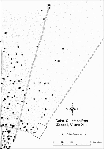
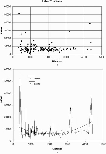
However, our GIS map, wherein the elite compounds had been highlighted (Figure 3), suggested otherwise, and further statistical testing was deemed necessary. Accordingly, we produced a scatter plot of vaulted buildings (whose presence is to be expected in any elite compound), against distance, along with a quadratic curve fit model (Figure 4). The plots revealed that although there is no direct linear relationship between labor investment and distance, the former peaked toward the center, descended toward the middle and peaked again toward the outliers, thus revealing a distinctive pattern not as dispersed or haphazard as Arnold and Ford concluded for Tikal. The statistical analysis has profound implications for the assessment of a model of the socioeconomic and political organization of this Maya center and others. The zoning reflects socioeconomic and political parameters with elite control clearly functioning at the core of the city and, in addition, elite presence strategically placed at its periphery. This may represent a perturbation of the concentric ring model but more profoundly, and precisely, begins to construct the hegemony of elite households and control within the site.
Localization of elite compounds at Coba's Zones I, XIII, and VI between Sacbes 3, 27, and 5.

(a) Scatter plot and (b) quadratic curve fit of Coba's Zones I, VI, and XIII work T data.

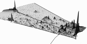
To further explore this pattern, the work T values for each structure were plotted as point features within the GIS and used as Z values to interpolate them as a continuous surface. An inverse distance weighted approach was applied for the interpolation process.Footnote 2
The results of this interpolation are shown in Figure 5. Here, it becomes immediately apparent that the higher work T values are closer to the central civic/ceremonial precincts, hence confirming that elite compounds tend to occur closer to the core than the periphery. The “spikes” observed further to the north some 3 to 4 km from the center are still within the range of a concentric model. Nevertheless, we felt that they had to be accounted for.
Interpolation results for work T values at Zones I, VI, and XIII of Coba.

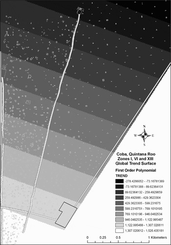
To this end, a global trend analysis was performed on the work T data. Global trend analysis is an analytical technique used to filter observed spatial data into regional (global) and residual or local components (the outliers). The coefficients of a best-fit polynomial surface are calculated to fit a set of data points spatially referenced, in this case to labor investment, to develop a generalized understanding of the spatial distribution of this phenomenon.Footnote 3
In this study, the main objective is to highlight the overall distribution of the elite compounds by smoothing over some of the local irregularities such as the presence of those on the periphery directly connected and more related to the core area by sacbeob, thus identifying the overall trend on the settlement pattern by detecting and isolating background “noise,” while identifying the factors that have produced this specific pattern.
Initially, a first-order polynomial equation was selected to obtain the trend surface of our data. The results are shown in Figure 6. It became immediately apparent that at this first level a trend toward a concentric arrangement of high work T values is present at Coba. Nevertheless, the presence of elite compounds on the periphery had to be explained, thus second- and third-order polynomial equations were performed. At the end, the third-order polynomial surface was selected because it provided the best representation of the global trend of the data (Figure 7). Note how some of the high values curve around the sacbeob and their termini showing how these account for the occurrence of the high work T values on the periphery, and in this way, substantiating the hypothesis of a concentric settlement pattern for Coba but also revealing significant elite control along the famous sacbe system leading to and from elite household compounds at remote termini. This new and refined understanding of the socioeconomic and political organization of the Maya center documents the power of the elite to place their households in strategic positions in relationship to the middle class and commoner household compounds.
First-order polynomial global trend surface of work T values.

Third-order polynomial global trend surface of work T values.

CONCLUSIONS
Coba represents a major urban center of the Classic Maya period. Through archaeological investigations carried out since the early 1970s, 6,595 structures have been identified and mapped, revealing the complex socioeconomic and political integration apparent in the heterogeneity of the size, shape, and quality of architecture observed across the city (Kintz and Fletcher Reference Kintz, Fletcher, Folan, Kintz and Fletcher1983:Table 13.4). Albeit this complexity in Coba, there is now a clear statistically demonstratable demarcation between commoner and elite compounds. Elite compounds are either isolated or associated with commoner household units. In the second case, the elite units associated with commoner dwellings probably served as foci for the control of barrios and partially isolated units with high-status, vaulted architecture that probably served interbarrio religious or political activities. In those cases where we find commoner households spatially associated with elite compounds, we hypothesize that these units were linked to elite families by kinship or affinity forming corporate social units similar to Levi-Strauss's concept of house (Anaya Hernandez Reference Anaya Hernández1994; Gillespie Reference Gillespie2000; Levi-Strauss Reference Levi-Strauss1981).
The results of our mapping efforts at Coba, directed by Folan and Stuart (1983), revealed what was assumed to be clear-cut concentric patterns as the norm in well-defined Classic period Maya urban centers, following Landa (1941). Elite compounds were concentrated at the core of the urban center and, in the case of Coba, combined with those located in the vicinity of sacbe and sacbe termini.
Despite Arnold and Ford's conclusions, our own explorative statistical tests run on the same labor investment parameters established by the former demonstrated a nonscattered pattern of elite compounds at Coba, which suggests that due to the spatial nature of the data, Kendall's tau-B test may not be the most adequate statistical approach. In this context, taking advantage of the spatial analytical capabilities that a GIS model can provide, first an inverse distance weighted interpolation method and later a global trend analysis were run on the work T values of Zones I, VI, and XIII. The results thus obtained confirmed the presence of a general concentric pattern of high-status architecture in Coba, and the strategic peripheral location of this type of architecture explained by the attraction force exercised by the sacbeob and their termini. The distribution of elite architecture at Coba reveals a complex socioeconomic, political, and religious ideology reflected in the settlement patterns. New statistical analysis on the spatial distribution of elite households at Coba documents the control elites wielded at the site. Lastly, analysis of the middle and lower class households may clarify their response to elite social, economic, and political control. Further analysis of nonelite spatial distribution and the social, economic, and political status of these members of the society will be a major contribution to advance our understanding of the social, economic, and political organization of major Maya urban centers.
RESUMEN
Coba constituyó uno de los mayores centros urbanos del período clásico maya. Las investigaciones arqueológicas que se han realizado en Coba han evidenciado la presencia de una compleja integración socioeconómica que se manifiesta en la heterogeneidad del tamaño, forma y elaboración arquitectónica de éste centro, donde, al mismo tiempo, existe una clara delimitación entre los conjuntos habitacionales de la elite y de la población en general y un sistema complejo de caminos elevados (sacbe'ob) (Figure 1).
Entre 1974 a 1976, Folan, Kintz y Fletcher (Reference Fletcher, Folan, Kintz and Fletcher1983) dirigidos por Folan y Stuart (1983), se dieron a la tarea de llevar a cabo el mapeo de gran parte de Coba. Los resultados de este proyecto revelaron que aparentemente existía un patrón de asentamiento donde los conjuntos habitacionales de la elite se concentraban hacia su núcleo. Concluímos que Coba presentaba un patrón de asentamiento concéntrico; sin embargo, en un trabajo publicado en 1980, Arnold y Ford (Reference Arnold and Ford1980) cuestionaron la validez de este patrón. Ellas argumentaron, con base en sus propios análisis, de que la inversión de mano de obra necesaria para la construcción de complejos habitacionales de la elite en un área de 9 km2 alrededor del núcleo de Tikal, era más bien disperso y no concéntrico como Coba sugiriéndonos que todos los centros urbanos en el área maya no tienen que tener el mismo tipo de patrón de asentamiento.
En este trabajo ponemos a prueba la hipótesis del patrón concéntrico, esta vez siguiendo los mismos parámetros de inversión de mano de obra utilizados por Arnold y Ford (Reference Arnold and Ford1980). También aprovechamos de las capacidades analíticas que los Sistemas de Información Geográfica (SIG) nos proporcionan para el análisis espacial de la distribución de los datos arqueológicos. Los resultados de este análisis corroboran la presencia de un patrón de asentamiento concéntrico en Coba como en el caso de Calakmul, Campeche (Fletcher et al. Reference Fletcher, Folan, May Hau, Folan, Folan, Fletcher, May Hau and Folan2001). A la vez, hemos hecho un análisis de la demografía de Coba y Calakmul para el período clásico tardío (Fletcher y Gann Reference Fletcher, Gann, Folan, Fletcher, Hau and Folan2001; Kintz y Fletcher Reference Fletcher, Folan, Kintz and Fletcher1983). Esta publicación representa una análisis reciente e interpretación de la organización socioeconómica y política de un centro urbano mayor de los mayas.
ACKNOWLEDGMENTS
A preliminary and much shorter version of this paper was presented in 2006 at the 71st Annual Meeting of the Society for American Archaeology, San Juan, Puerto Rico. We wish to thank Arqlga. Maria Jose Con Uribe for her interest in our project as well as that of the National Geographic Society and Instituto Nacional de Antropología e Historia in the Coba Archaeological Mapping Project: 1972–1974. We also wish to acknowledge helpful suggestions from Rafael Cobos, Payson Sheets, and an anonymous reviewer that spurred us toward a better understanding of urbanism in, and around, Coba, Quintana Roo.