

OPPIDA AND HILLFORTS IN IRON AGE NORTHERN SPAIN
Large fortified settlements, usually known as oppida, are one of the main features of Late Iron Age Europe (Collis Reference Collis1984; Fernández-Götz et al. Reference Fernández-Götz, Wendling and Winger2014a; Reference Fernández-Götz2014b; Fichtl 2005; Reference Fichtl2012a; Sievers & Schönfelder Reference Sievers and Schönfelder2012). There are more than 150 oppida from the 2nd and 1st centuries bc identified to date between France and Hungary, with some outstanding and particularly well-explored examples such as Bibracte, Corent, Titelberg, or Manching. Recent research has made it necessary to reassess many of the traditional interpretations about the genesis and functions of these centres. Together with their role in production and trade, new approaches also stress their political and religious significance (Fernández-Götz Reference Fernández-Götz2014a; Reference Fernández-Götz2014b; Fichtl Reference Fichtl2012a).
Traditionally, the central and northern regions of the Iberian Peninsula have not been included in international debates on Iron Age urbanisation. This is mainly due to the ‘peripheral’ location of the Iberian Peninsula in relation to Central Europe and the Mediterranean, as well as to the historiography of so-called ‘Celtic’ archaeology with its emphasis in the archaeological cultures of Hallstatt and La Tène, which are only scarcely represented south of the Pyrenees (Collis Reference Collis2006). However, the settlement patterns of the central and northern areas of Iberia show considerable similarities with the situation found in wide parts of Temperate Europe during the 1st millennium bc (Almagro-Gorbea Reference Almagro-Gorbea2014; Lorrio & Ruiz Zapatero Reference Lorrio and Ruiz Zapatero2005). In the Late Iron Age, the settlement landscape of central and northern Spain was characterised by a complex occupation based on rural sites such as farms and hamlets, small fortified hillforts (castros in Spanish) and oppida (see eg, Álvarez-Sanchís et al. 2011; Serna et al. Reference Serna, Martínez Velasco and Fernández Acebo2010). The oppida are large fortified settlements of generally more than 10 ha, similar in size and functions to those that can be found in the rest of Western Europe (Almagro-Gorbea Reference Almagro-Gorbea2002, 50–7; Torres-Martínez Reference Torres-Martínez2011, 274–80). They were centres of production and trade which also played a key role as political and religious focal points for the populations of a wide rural environment. The distinction between hillforts and oppida is mostly based on the smaller size of the former, probably related to more reduced areas of influence than those of the oppida, which would have acted as central places for larger territories. Whereas small hillforts existed since the beginnings of the Iron Age, the development of the oppida in northern Iberia is associated with the last three centuries bc, as the result of agglomeration processes that went hand in hand with population growth and rising production in a framework of increasing contacts and tensions with the expanding Roman power (Serna et al. Reference Serna, Martínez Velasco and Fernández Acebo2010; Torres-Martínez Reference Torres-Martínez2011).
However, it should be noted that not all areas developed centralised settlement patterns around the oppida. In mountainous territories with small valleys we find a scattered settlement pattern without large centres throughout the whole of the Iron Age. In these remote areas, small settlements occupied the available space showing an adaption to the mountainous environment. This tendency is particularly noticeable in the west of the Cantabrian region (Almagro-Gorbea Reference Almagro-Gorbea2002), but can also be found in other mountainous areas of the Iberian Peninsula. Big hillforts and oppida developed in regions with open valleys and in natural communication routes, where we find a concentrated and hierarchical settlement pattern with major centres, smaller fortified sites, and open rural settlements (Torres-Martínez Reference Torres-Martínez2011). During the Late Iron Age, the territory would have been organised in different political entities with the oppida acting as central places, and subdivided in smaller units that allowed a complex hierarchical structuring of the landscape (Torres-Martínez Reference Torres-Martínez2011, 274–84, 365–83; Reference Torres-Martínez2014). One of the most noteworthy examples of an oppidum in the north of the Iberian Peninsula is Monte Bernorio.
BRIEF HISTORY OF THE INTERVENTIONS IN THE ARCHAEOLOGICAL AREA OF MONTE BERNORIO
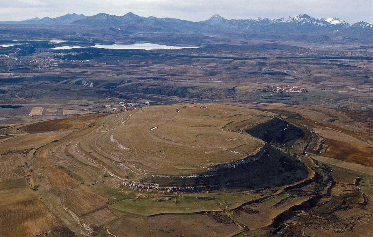
The site of Monte Bernorio (Pomar de Valdivia, Palencia, Spain) is located at the top of the homonymous mountain (Fig. 1). It occupies the flat top of the mountain, of about 28 ha, which makes it one of the largest Iron Age fortified sites of the whole of the Iberian Peninsula. This paper constitutes the first updated synthesis of the archaeological works that have taken place over the last decade. They have turned Monte Bernorio into a key site for the understanding of Iron Age societies in northern Iberia, both in terms of fortification systems and material culture evidence. Thanks to the most recent discoveries related to the Roman Conquest by Emperor Augustus, it has also become a prime example for the study of the Cantabrian Wars, representing one of the most impressive battlefields of Rome’s imperial expansion in Western Europe.
Aerial photography of the Bernorio mountain at the foothills of the Cantabrian Mountains (IMBEAC)

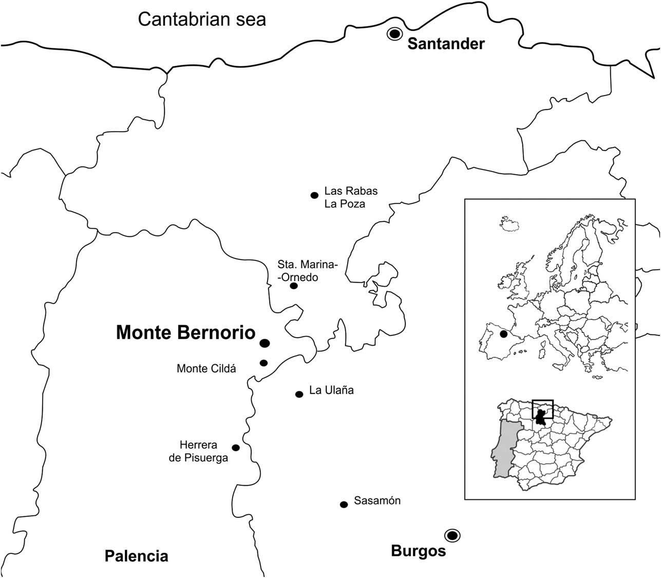
The settlement takes up the upper part and the side of the Bernorio mountain, a limestone mound 1173 m high. It is located in a strategic position, at the centre of the foothills of the Cantabrian Mountains, in an area of transition to the Northern Inner Plateau (Meseta) of the Iberian Peninsula (Fig. 2). It dominates an important intersection of natural routes in this mountainous territory. These routes allow north–south communication through the mountains through their central area, making the advance from the Northern Plateau to the Cantabrian Sea possible. They also control the natural east–west route, parallel to the mountains that connect it to various natural itineraries, from the Pyrenees and the Mediterranean (through the Ebro river), to the east, Asturias and Galicia.
Location of the oppidum of Monte Bernorio in Northern Spain (IMBEAC)

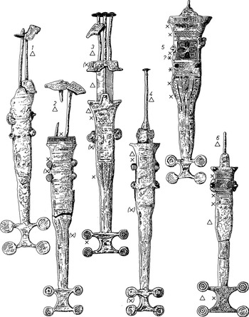
The first field seasons at Monte Bernorio were conducted by Romualdo Moro in the 1890s. Moro excavated the acropolis of the settlement, and possibly in other areas, but the results made him give up and start focusing on the necropolis, where he knew there were ancient metallic objects. There, he found the famous ‘Monte Bernorio type’ daggers and some other materials that were part of the burial goods of the tumuli (Moro Reference Moro1891) (Fig. 3). These materials, part of the Bernorio collection of the Marqués de Comillas, were studied during the first half of the 20th century by Spanish and German scholars such as J. Cabré Aguiló, A. Schulten, and, later, by W. Schüle (Barril Reference Barril1995; Reference Barril1999, 46–51; Schüle Reference Schüle1969; Schulten Reference Schulten1943).
‘Monte Bernorio type’ daggers from the necropolis (after Schüle Reference Schüle1969)

The strategic location of the Bernorio mountain lead to its occupation during the Spanish Civil War (1936–1939). It was fortified and became the scene of several battles that took place in this region, where the Frente Norte (North Front) was located (Torres-Martínez & Domínguez Reference Torres-Martínez and Domínguez2008). Not long after the end of the conflict, J. San Valero began the first archaeological interventions. They took place in 1943, 1944, and 1959, throughout several areas of the oppidum and the necropolis (San Valero Reference San Valero1944; Reference San Valero1960) previously excavated by R. Moro. However, after the 1959 season, the interventions stopped for nearly half a century.
The new archaeological fieldwork seasons, part of the ‘Monte Bernorio in its Environment’ Project,Footnote 1 have been carried out since 2004. They have allowed the recovery of abundant archaeological materials from the settlement and the necropolis area, especially from the Early and Late Iron Age (Torres-Martínez et al. Reference Torres-Martínez, Martínez-Velasco and Serna2013). These new data have been essential to update the existing information about the site.
THE FORTIFICATION SYSTEM: WALLS AND MULTIVALLATE EARTHWORKS
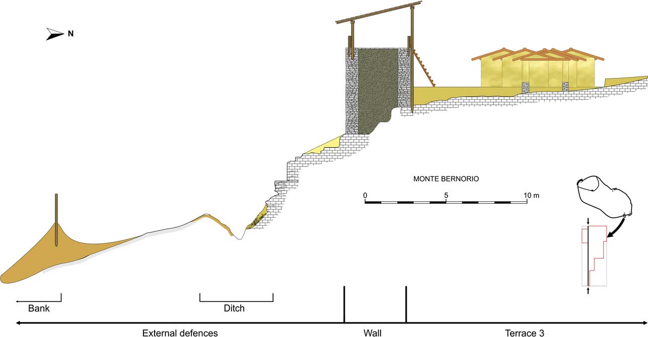
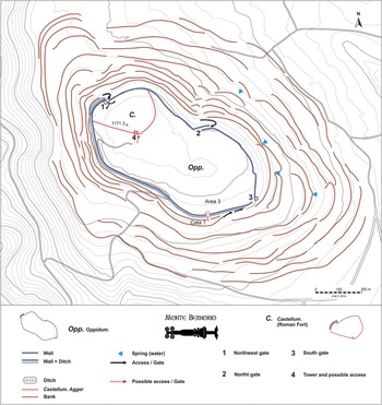
According to the wall sections currently documented, at the final moment of protohistoric occupation, the upper part of the settlement was protected by a perimeter wall approximately 1700 m in length. The average thickness of the structure was about 3–4 m, and the material used to build it was limestone from the same mountain (Torres-Martínez et al. Reference Torres-Martínez, Martínez-Velasco and Serna2013, 22–9). The wall stood on the steep side of the mountain, with two different heights, the inner face being at a higher level than the exterior. The outer face was laid on the hardest outcrop of the bedrock of the steep side of the mountain. Its inner face was laid on big blocks of rock that stood on another level of limestone, located slightly higher, on the terrace. The wall was created using a simple technique: two walls with a filling of earth and stones. The walls were made of irregular or partially irregular masonry. However, the blocks of stone were selected, to create a more homogeneous exterior. This technique has been documented in other protohistoric walls of the Cantabrian territory (see Fernández Acebo et al. Reference Fernández Acebo, Martínez-Velasco and Serna2010).
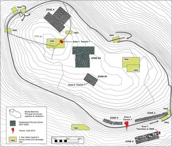
The wall had at least three access routes, with their respective gates. There are remains of the fortifications that defended two of them (north-western and northern gates). The structure of the north-western gate was a tower that dominated the ramp and angled trail access, between two parallel sections of wall. The defensive structure of the northern gate was established through a long narrowing formed by two parallel sections of wall. The southern gate, now destroyed, still has some remains of the foundation of a large angled ramp insert in a narrow entrance, possibly also fortified. This kind of fortified door is present at other sites in the northern Iberian Peninsula, such as the oppidum of Cerro de la Maza (Pedrosa de Valdeporres, Burgos; Peralta Reference Peralta2003, 296), the hillfort of Munoaundi (Azkoitia-Azpeitia, Gipuzkoa; Peñalver & San José Reference Peñalver and San José2011, 100–1), and the oppidum of Arrola (Arratzu-Nabarniz-Mendata, Bizkaia; Valdés Reference Valdés2009, 81–3; Llanos et al. Reference Llanos, Armendáriz, Castiella, Peñalver, Sáenz and Unzueta2009, 258–60). Apart from these entrance fortifications, the geomagnetic surveys carried out by a team from the University of Frankfurt am Main in 2007 and 2008, and directed by Prof. Felix Teichner, detected the presence of some structures attached to the wall. These could be defensive structures as well. There are known examples of this kind of structure in other settlements from the north of the Iberian Peninsula, such as the oppidum of Campa Torres (Gijón, Asturias) or the hillfort of Llagú (Latores, Oviedo, Asturias; Maya & Cuesta Reference Maya and Cuesta2001, 40–2, 48–9; Berrocal-Rangel et al. Reference Berrocal-Rangel, Martínez Seco and Ruiz Triviño2002, 102–3).
The wall of Monte Bernorio leads to a cliff about 3–6 m high (depending on the area), which would have served as a quarry from where the stone was taken to build the fortification. There is a ditch of triangular section, 4 m wide and 2 m deep, below the cliff, identified at least in a great part of the perimeter. The edge of the ditch is clearly delimited by a series of stones tucked in a clayey yellow soil, which covers the ditch, creating a ‘V’ shape. These stones could be used to fix wooden stakes of the cervi type (Fig. 4). The ditch excavated in the 1940s by J. San Valero, on the north-eastern side of the mountain, is 5 m wide in some areas, and has a preserved depth of 1.80 m (San Valero Reference San Valero1944, 35–6; Torres-Martínez et al. Reference Torres-Martínez, Martínez-Velasco and Serna2013, 23).
Upper wall and ditch of the oppidum (IMBEAC)
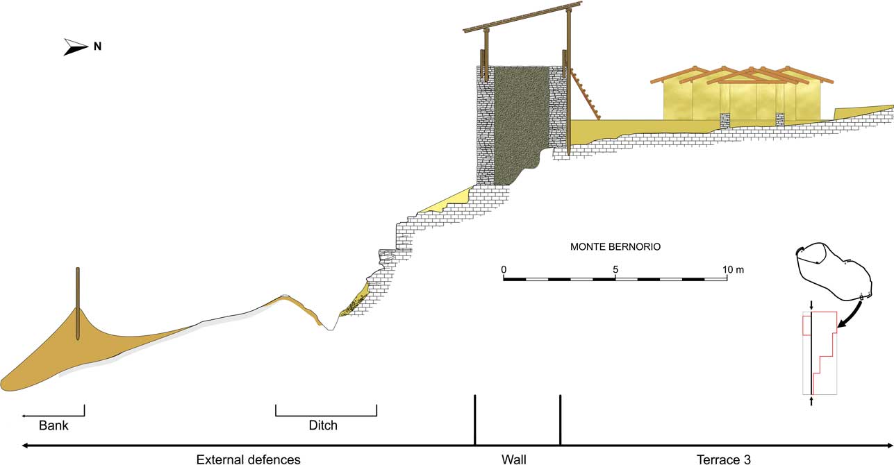
Apart from the upper wall and ditch, the area surrounding the perimeter of the Bernorio mountain has a system of large concentric earthen ramparts, which expand the area of the oppidum to at least 90 ha. These defences – identifiable in aerial photographs and LiDAR images, and partly still visible in the landscape – are built as a series of discontinuous ramparts (multivallate) and constitute one of the most impressive defensive works in the whole of Iron Age Europe (Fig. 5). The fortification lines have slightly curved and rounded edges. Recent excavations at one of the earth ramparts has confirmed the assumed Late Iron Age date of this fortification system, which must have been erected in close association with the previously mentioned ditch of the upper wall. The remains of these multivallate ramparts create the current terraces present on the side of the Bernorio mountain, due to their gradual destruction. They also act as a wall that contains the materials from the upper areas. This system of artificial terraces and ramparts is extremely complex and would have required a great investment of collective work. These kind of defences have been also documented at other sites in northern Spain (Camino Reference Camino1995, 158–65; Torres-Martínez Reference Torres-Martínez2011, 289–92), and are also common in areas of Central and Western Europe (Cunliffe Reference Cunliffe2005, 313–23, 357–8; Fichtl 2005, 42–63; 2012a, 32–8; Ralston Reference Ralston2006, 46–8, 61–6).
Multivallate earthworks enclosing an area of 90 ha (IMBEAC)

THE INTERNAL STRUCTURE OF THE OPPIDUM
The occupation of Monte Bernorio ranges from the Late Bronze Age to the Late Iron Age (9th/8th to 1st centuries bc). Evidences of the first occupation stages have been found at the highest part of the mountain, as well as on the terrace of the later southern wall. The large amount of Late Bronze Age and Early Iron Age material (mostly pottery) recovered at different parts of the site testifies to an important occupation, although so far no building structures have been documented for these early phases, probably due to their destruction by later construction activity. The Late Iron Age oppidum developed mostly from the 3rd century bc onwards. The abandonment of this large settlement is characterised by remains of the fire that destroyed the site. This level, as indicated by the recovered evidences, would be present in the whole settlement. It is ash-coloured and has numerous remains of coal and burnt wood. The destruction presumably took place during the Roman Conquest by Emperor Augustus (see below).
The inner structure of the settlement consists of a series of natural terraces reinforced by retaining walls where the structures are located. These terraces are located along the mountain’s top and southern side. The geomagnetic surveys indicate that probably the whole surface of the oppidum had structures of different dimensions, which were structured, but not regularly (Fig. 6). This indicates the construction of ‘lines of structures’ or ‘blocks’, with spaces for different activities and transit areas. Foremost, the access trails to two of the entrances are sufficiently wide and have levelled platforms, which would allow the access of carts.
Plan of the excavated and geomagnetically surveyed areas (IMBEAC)

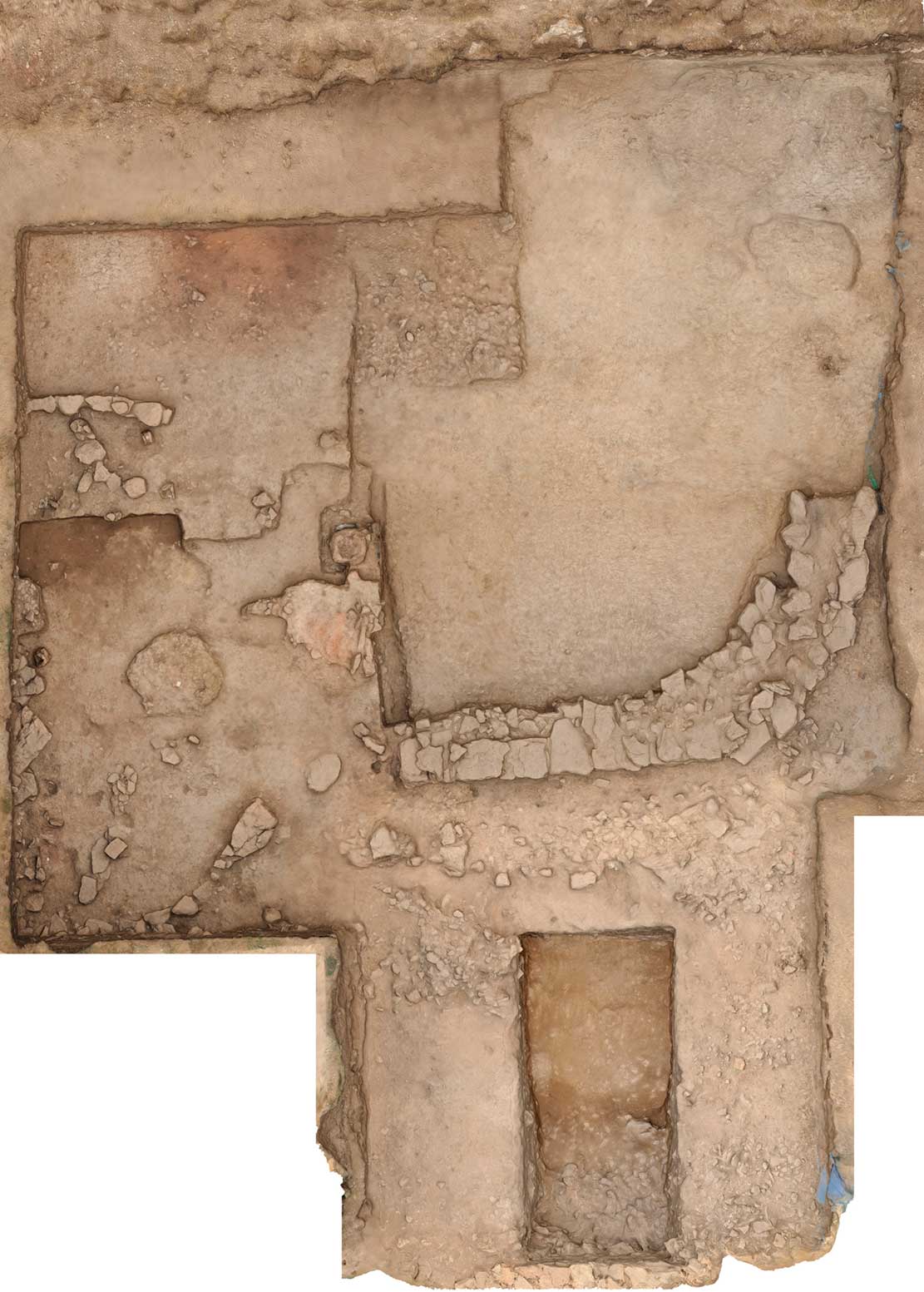
At the end of the Late Iron Age, the structures had oval and rectangular ground plans with rounded corners (Fig. 7). The houses had stone bases, inner posts, and wattle and daub walls. The daub was created using mud, straw and other plants. The earth came from the site itself and other mountainous areas, but the walls of previous structures were also reused.
Excavated house structure from area 3, stone basement (IMBEAC)
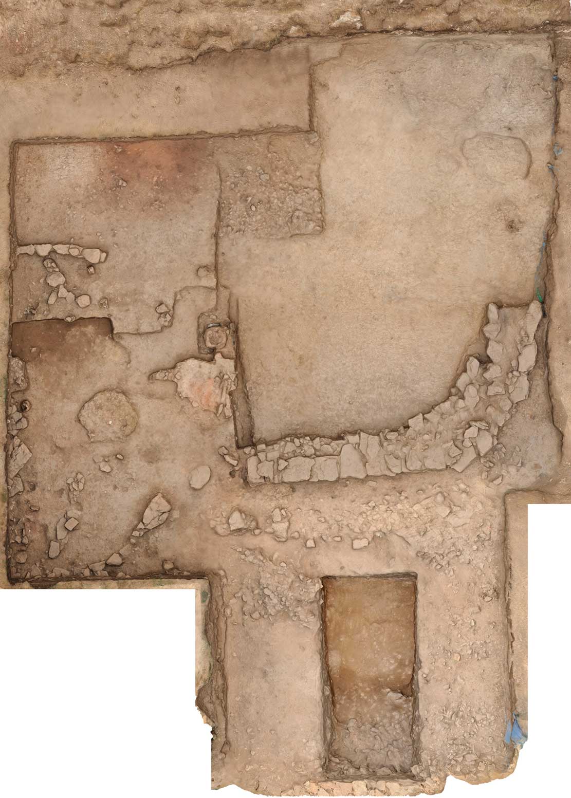
The structure defined as UE 300 has a very thick stone base, which is interpreted as the foundation of a wall and a 40 cm thick and 30 cm high continuous bench. Several fragments of wall of different sizes, fired during a conflagration, have been recovered. They are plastered, and sometimes have painted decorations. The layers of painting identified have different colours, forming strips, and sometimes overlying painted layers. One of the fragments has remains of a sign or a schematic figure. A fragment of daub with a hand mark has also been recovered.
Another find associated with UE 300 is a hearth built over a base of stones and mud, with potsherds to improve the heat resistance. It is square shaped and has several layers that could indicate successive reconstructions. It is associated to the structure of what seems to be a half underground hearth with a circular hole on top, and a lower hole which could be used to fuel it. They were built using mud, and wooden planks or strips to delimit them, some of which have been found burnt.
Among the debris of the structures, remains of several newborn babies were found, buried (not cremated) inside the dwellings, usually near to the hearths (Torres-Martínez et al. Reference Torres-Martínez, Domínguez and Carnicero2012a). This custom has been well-documented along the northern Iberian Peninsula (Fernández Crespo Reference Fernández Crespo2008, 200–6; Gusi & Muriel Reference Gusi Jener and Muriel Ortíz2008).
PRODUCTION AND CONSUMPTION AT MONTE BERNORIO
A great amount of materials of all kinds has been documented in the interior of the oppidum of Monte Bernorio, which indicates intense occupation of the settlement. The amount, variety, and characteristics of the objects recovered (ornaments, tools, weapons, imported objects, etc) clearly indicate the rich material culture possessed by the oppidum’s inhabitants. This contrasts with what can usually be found at other settlements of the Cantabrian region, abandoned or destroyed, where environmental and soil conditions do not help the preservation of most materials. In this respect the new archaeological interventions at Monte Bernorio can help us understand the subsistence and production strategies of the Iron Age communities of the Cantabrian region.
Lithic technology
A great number of fragments and complete grinding stones, both larger stationary stones and hand held stones, have been found inside the oppidum. Some fragments of querns have also been recovered, as well as one upper stone and a base. These objects indicate the intense processing of cereals and other plants. Pestles, sharpening stones, and polishing stones of all kinds, made of quartzite, are abundant.
Fauna
Approximately 20,000 animal remains have been found to date at Monte Bernorio. The analysis of the domestic animals shows similar results to other Iron Age sites from the north of the Iberian Peninsula. Overall, the bovidae (Bos taurus) are the most commonly reared and consumed animals in northern Iberia, followed by either pigs and/or ovicaprines (Ovis aries/Capra hircus), depending on the area. This is what the analysis of the animal remains of hillforts such as La Hoya (Laguardia, Álava), Castro de Peñas de Oro (Vitoriano, Álava), or Berbería (Barrio, Álava) show. At those sites, the Late Iron Age levels also show the predominance of the consumption of bovidae (Bos taurus) (Mariezkurrena Reference Mariezkurrena1990). This is a uniform pattern in all the area of the Cantabrian region, from Galicia to Navarra, as shown by the publications regarding this topic. The specialisation in the exploitation of bovidae can be seen as an economic or cultural adaptation to a mountainous environment as in the north of the Iberian Peninsula (Castaños & Castaños Reference Castaños and Castaños2009; Liesau & García Reference Liesau and García García2005, 262–5; Torres-Martínez Reference Torres-Martínez2015; Vázquez Reference Vázquez1986, 233).
The consumption of the different parts of the animals is pretty intense, as indicated by the fragmentation of the bones. Cut marks show the use of the skin, and carved bones and antlers have been found. Through the remains, which show certain modifications and burnt areas, we can see that the meat was cooked, boiled, and roasted. This is documented in other areas of the same region (Torres-Martínez Reference Torres-Martínez2011, 155–9, 170–2; Vázquez Reference Vázquez1986, 231–9).
The number of bovidae skulls found in the excavated area of Monte Bernorio, five, should also be highlighted. There is certainty that at least two of them were part of a deposit, presumably ritual. The first was found under the packed-earth floor of a house. The second was found under the stone base of a large house of rectangular shape with rounded corners. It was placed inside a pit, in direct contact with the bedrock and covered by large stones. The rest of the skulls could have been part of the decoration/protection of the dwellings of the excavated terrace.
The excavation of the ditch in the south of the site has discovered a great amount of animal remains right under the perimeter wall debris. They have clear cut marks which indicate consumption. The species found are very similar to those found at the domestic area: bovidae (Bos), suidae (Sus), ovicaprines (Ovis/Capra), and equidae (Equus). This concentration of animal bones was found along with materials such as a ritually disabled iron spearhead; a decorated antler knife handle; sherds of painted wheel-made pottery; and fragments of a tripod vase. The large amount of animal remains along with materials that can usually be found in ritual contexts, and a disabled weapon, are a clear evidence of a ritual deposit. It is probably related to the remains of a great community feast and the previous sacrifice of a large number of animals. This way, Monte Bernorio can be added to the increasing number of oppida of Western Europe that have evidences of ritual practices and collective feasts. This highlights the relevance of these settlements for the understanding of collective identities (Fernández-Götz Reference Fernández-Götz2014b).
As at other Iron Age sites from the northern Iberian Peninsula (Castiella Reference Castiella1994), Monte Bernorio has evidences for the manufacture of bone and antler. The materials found are mainly knife handles and tools, but also needles and other instruments (Barril Reference Barril1995; San Valero Reference San Valero1944; Reference San Valero1960). In this sense a relevant find is a knife handle decorated with lines and concentric circles, which was recovered from the ditch.
Ceramics
Nearly a ton of ceramics was recovered during the archaeological interventions at Monte Bernorio. The finds include hand-built as well as wheel-made pottery, often decorated. Other types of pottery identified were made using slow wheels, or hand-built using refined clay and decorated. The chronological sequence of these materials is complicated, following the traditional limitations of Iron Age archaeology in the Cantabrian region. The classifications created by A. Castiella and the revision of other publications have helped us differentiate Late Bronze Age, Early Iron Age, and Late Iron Age pottery (Castiella Reference Castiella1977; Torres-Martínez Reference Torres-Martínez2011, 198–201). Some other remains, currently being studied, could be assigned to the Bronze Age as well.
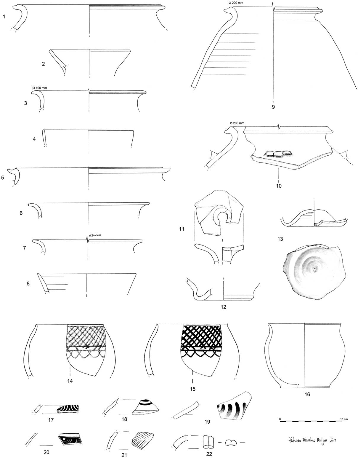
The wheel-made pottery can be found all over the site. It is very varied and abundant. It has decorations of concentric circles, lines, grids, and strokes of different kinds, all very similar to the Celtiberian pottery styles from the Duero valley, and the Celtiberian and Iberian styles from the Ebro valley (Castiella Reference Castiella1977; Llanos Reference Llanos1992, 443–4; Torres-Martínez Reference Torres-Martínez2011, 203–6) (Fig. 8). Among the types of pottery identified, there are some related to the consumption and offering of food and drink, storage vessels, and special objects such as funnels, with thin and thick necks, as well as some fragments of lids. A small fragment of ceramic which belonged to a double chamber kiln was also found. It may have been part of a thick grill, and it is similar to a find from the hillfort of Danebury in southern Britain (Cunliffe Reference Cunliffe2003, 83 & fig. 45). Unfired wheel-made pottery sherds were found in the ditch, and were possibly part of a broken vessel, which could indicate the existence of a pottery workshop nearby.
Wheel-made pottery from Monte Bernorio (IMBEAC)
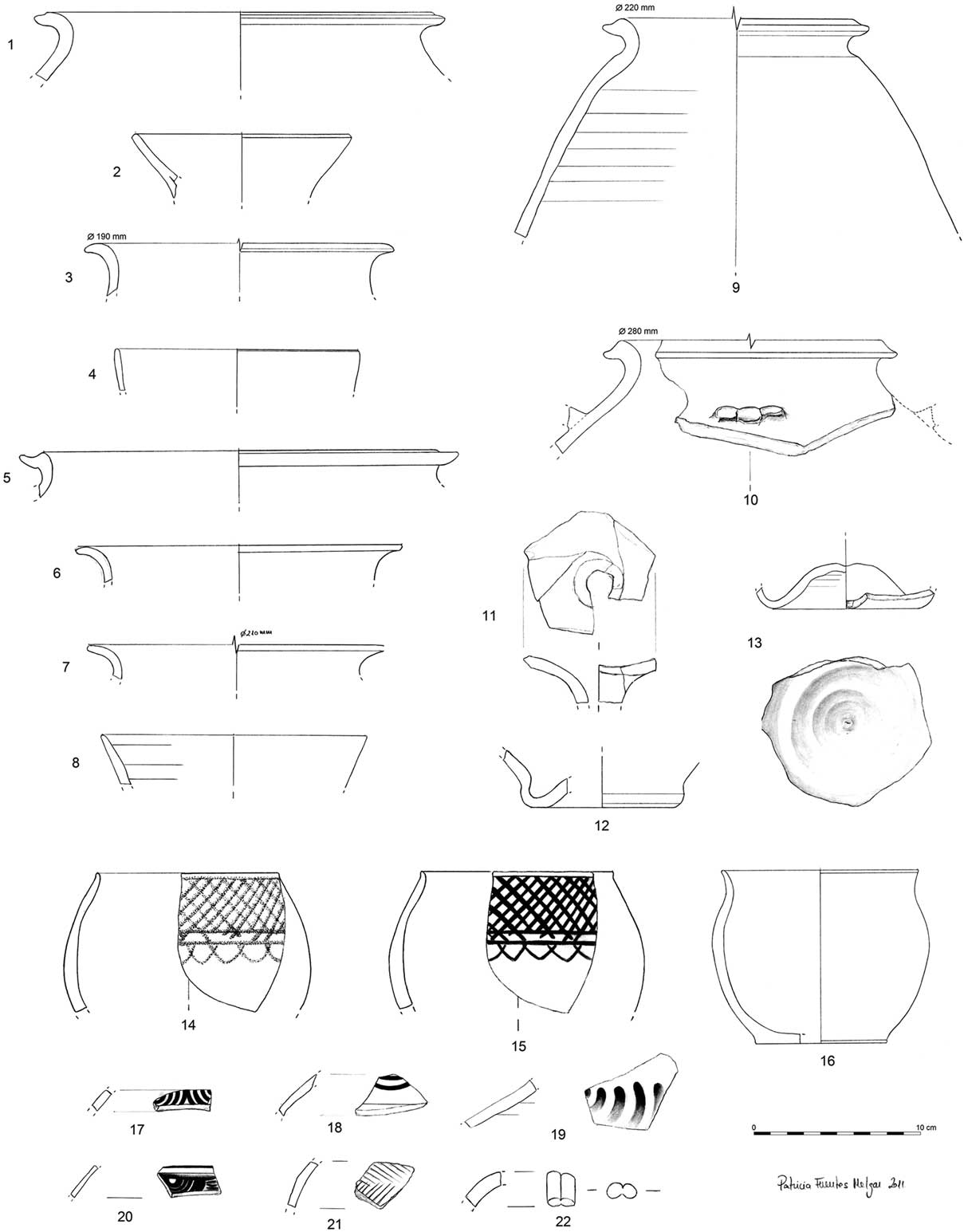
Some objects made of terracotta have been found as well: marbles, possibly toys; and beads or pendants. Spindle-whorls in different shapes and sizes are abundant (with or without decoration), as well as loomweights (some of them complete), which indicate the production of textiles using fibres of vegetal and animal origin. Finally, some of what seem like circular ceramic (and stone) fishing net weights, pierced in the centre, have also been recovered.
Glass beads
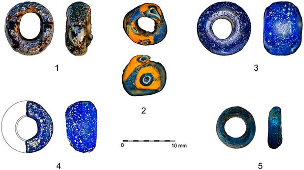
Glass beads are one of the main adornments found at the settlement of Monte Bernorio. The five beads found (two of them fragmented) can be dated from the 3rd to the 1st centuries bc due to their typology, which fits with the general stratigraphy of the site. They represent the highest concentration of Iron Age glass beads in the Cantabrian region and are testimony of long-distance networks. Four of the beads are cobalt blue in colour, and have no decoration, whereas another blue bead has a triangular shape with rounded corners and is decorated with concentric circles in yellow and dark blue (Torres-Martínez et al. Reference Torres-Martínez, Martínez-Velasco and de Luis Mariñoforthcoming) (Fig. 9).
Glass beads recovered at the excavations (IMBEAC)

Metals
The metal objects are distinctively well preserved. The bronze conservation is good except in the cases in which it was affected by fire. Some of the bronze adornments are complete and maintain their physical characteristics, such as their flexibility. The iron is much more affected by corrosion. However, the preservation is good overall. Several iron objects, such as blades and fragments of blades from axes and knives, rivets, sheets, fragments from tools, needles, etc, were found. Some remains of knife blades and handles of ‘Monte Bernorio type’ daggers have also been recovered. We should also emphasise the discovery of a razor, with its complete bone handle.
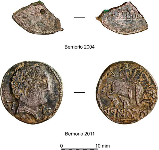
Among the bronze objects we should highlight the presence of rivets and fragments of what seem to be cauldrons, very fragmented and related to the surface of the site or to the earlier levels. There are also many rivets that were part of belts, as well as fragments of bronze sheets and bracelets, different kinds of brooches (La Tene I, Omega, Alesia, etc), fragments of fibulae springs and needles, ends of fibulae or torcs, rings, and hair rings. Pendants are abundant, especially the spiralling body needles which were part of pectorals. Sewing needles of various shapes, fragments of bowls, and other unidentified materials have also been recovered. Finally, two coins are known to date: a denarius of TuRIAZU (Turiaso, Tarazona, Zaragoza) and a quarter of another denarius from BoLŠCeN (Bolskan, Huesca) (Fig. 10).
Denarius of TuRIAZU and quarter of denarius from BoLŠCeN (IMBEAC)

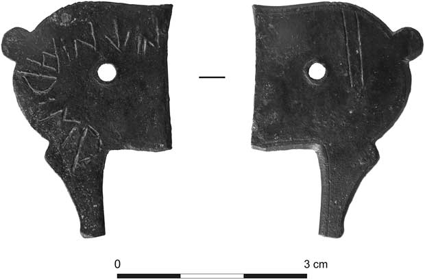
Tessera Hospitalis: From all the metal objects, we must highlight the recent find in 2012 of a tessera hospitalis with written text (Torres-Martínez & Ballester Reference Torres-Martínez and Ballester2014). These objects were legal documents which certified an agreement between two communities or individuals. This is one of only two tesserae of this kind found in context during an archaeological excavation in Spain, and the first in the north of the Iberian Peninsula. The writing is indigenous, not Latin, and uses the Iberian hemialphabet in its Celtiberian western variety. The language is clearly Indoeuropean and Celtic. The brief text reinforces the evidences of Celtic languages in the Cantabrian region, similar, but not identical, to the Celtiberian language from the Ebro valley (Fig. 11).
Tessera hospitalis with inscription in Celtic language (IMBEAC)

The creation of the document shows that writing was used by the peoples of the Cantabrian region during the 2nd–1st centuries bc, at least for legal texts like this one. It is a document that shows a firm writing, written by an artisan who knew how to use this code with ease. However, the most important aspect of the document is that it refers indirectly to the existence of what we could call ‘citizenship rights’ of the polities or indigenous communities, with a distinguishing treatment to foreigners. It is precisely this distinctive treatment to members of other communities that the kind of agreement represented by the tesserae hospitalis try to rectify. These pacts could be established between individuals, families, and/or entities like ethnic groups or neighbouring units related to hillforts or castelli. Evidence like the newly discovered tessera from Monte Bernorio clearly reflect the complexity of the peoples that inhabited the Cantabrian region just before the Roman Conquest (Albertos Reference Albertos1975; Santos Reference Santos1998; Torres-Martínez Reference Torres-Martínez2011, 274–84; Reference Torres-Martínez2014).
THE CANTABRIAN WARS AND THE DESTRUCTION OF THE OPPIDUM
The evidence recovered during the archaeological campaigns indicates that the attack of the Roman troops was the cause of Monte Bernorio’s destruction at the end of the Iron Age. This event occurred during the Bellum Cantabricum et Asturicum carried out by Emperor Augustus (29–19bc), thus completing the conquest of the last independent populations of the Iberian Peninsula.
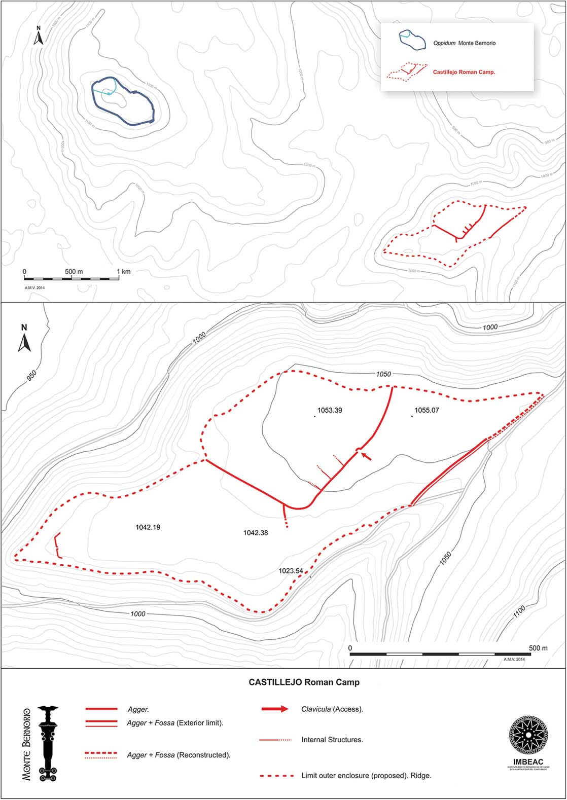
Immediately below Monte Bernorio, there is a plain called La Lastra, where a Roman military camp, ‘El Castillejo’, is located (Fig. 12). With an area of 41 ha, this structure is currently one of the biggest Roman camps known in Europe (Peralta Reference Peralta2003, 301–3). Particularly outstanding is the central rectangular camp with rounded corners. It had an area of 18 ha and was protected by a vallum made of earth and stone, and a fossa fastigata (V-shaped ditch). Together with this enclosure, there are other structures that completely fill the available space. What appears to be the main access is just in front of Monte Bernorio. The attack on the oppidum definitely came from this military camp. It was developed during the first stage of the wars against the Cantabri and Astures, during which the Roman legions were under the direct command of Augustus, who could have been directly involved in this attack against Monte Bernorio (Torres-Martínez et al. Reference Torres-Martínez, Serna and Domínguez2011, 137–43; Reference Torres-Martínez, Martínez-Velasco and Pérez2012b).
Location and plan of the Roman military camp of ‘El Castillejo’ (IMBEAC)

The Roman Conquest has left an indelible mark on the destruction level that indicates the end of the occupation of the oppidum. Both indigenous and Roman military equipment has been found at the southern area of Monte Bernorio, as well as items that could be attributed to both the Romans and the inhabitants of the oppidum (Peralta Reference Peralta2003, 280–2, 301–3; Reference Peralta2004, 33–4; Torres-Martínez et al. Reference Torres-Martínez, Serna and Domínguez2011, 132–5; Reference Torres-Martínez, Martínez-Velasco and Pérez2012b, 529–31). Elements of Roman typology such as buckles, studs, and rivets have been recovered, as well as fragments of what could be pilum (javelin) heads. Studs from caligae (soldier’s sandals) are a common find, and two pieces of legionary soldiers’ rings, which would have had mounted seals carved on gems, have also been discovered; they are characteristic of legionary soldiers who were Roman citizens. These materials would have been part of the equipment, weapons, and belongings of the legionary soldiers who attacked the oppidum of Monte Bernorio.
There are other materials that are clearly identified as indigenous, because of their manufacture, style or decoration. This would be the case of objects such as the small bifacial axe, the laurel leaf shaped javelin head with a long rod, or the fragments of arrowheads and ‘curved profile’ knife blades. There are also elements of adornment: decorated plaques, hair rings, etc.
Various remains of weaponry and clothing can be attributed to both Roman and indigenous combatants. They are sometimes damaged or broken as a result of impacts. Among these elements we can find bronze biglobular dagger handle ends, and the iron elements of the sheaths and straps used to carry this kind of dagger. Fragments of fasteners and hooks in bronze and iron have also been found. Another important find is an iron ring with spring for a gladius sheath, broken by an impact.
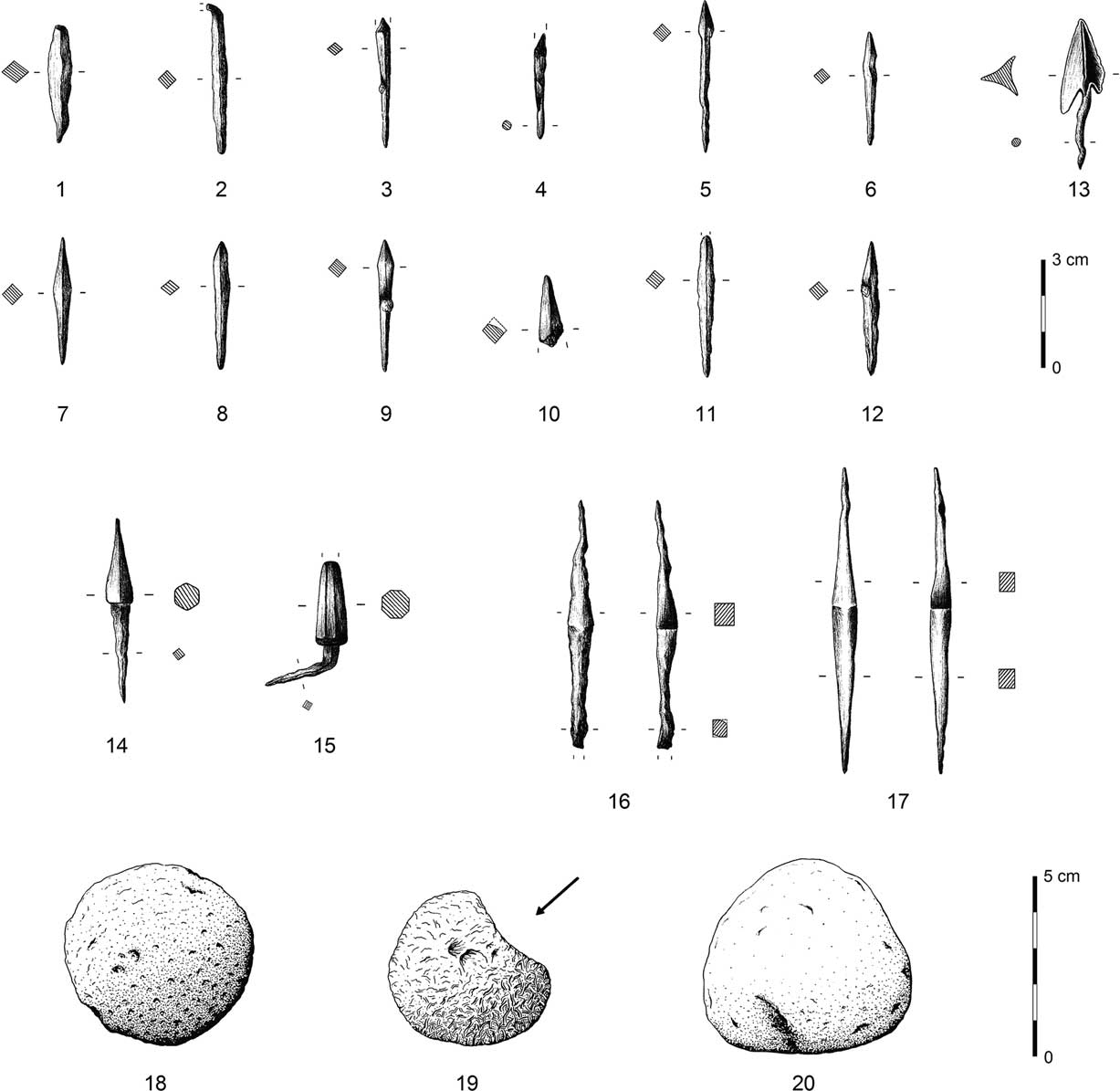
The numerous finds of projectiles prove the use of artillery. Most of the arrow type projectiles found are small and of pyramidal shape, belonging to the so-called ‘Syrian type’ (Fig. 13). Some of these arrowheads have been found stuck to the outer face of the wall, or at its feet. They are related to the materials found at the Castillejo camp and to those found at the hillfort of La Loma (Santibáñez de la Peña, Palencia; Fernández Ibáñez Reference Fernández Ibáñez2007, 404; Peralta Reference Peralta2003, 148, 280–2, 301–6; Reference Peralta2004, 33–4).
Selection of Roman projectiles found at Monte Bernorio: 1–13 arrowheads (sagittae); 14–18 pila catapultaria; 18–20 stone projectiles (ballistae) (IMBEAC)

Recent discoveries imply that cheiroballistra or manubalista devices (hand catapults to throw arrows) were used in the assault of Monte Bernorio. These projectiles are smaller and shorter than those used for a pila catapultaria. There have been two finds of pyramidal shaped and multifaceted projectiles, with hexagonal or octagonal sections respectively, with cylindrical-prismatic barbs which would fit on the handles used. The heads of the two projectiles found are carefully manufactured creating a section that converges on the point, which improved the aerodynamic characteristics, the strength, and penetration ability of the arrows. The point of both projectiles looks blunt due to a heavy impact (Torres-Martínez et al. Reference Torres-Martínez, Martínez-Velasco and Pérez2012b, 531–33, 537).
After the destruction of the oppidum, the Romans set a castellum in the north-western part of the mountain, which stayed for several decades. They built an earthen agger (rampart), which was later replaced by an agger made of stone. The enclosure has at least two consecutive stages of occupation. This fortification is related to the territorial control and the strategic routes of the Cantabrian Mountains, which were controlled by Monte Bernorio during the war and, afterwards, during the pacification that took place during the first part of the 1st century ad (Torres-Martínez et al. Reference Torres-Martínez, Serna and Domínguez2011, 137–43; Reference Torres-Martínez, Martínez-Velasco and Pérez2012b, 529).
CONCLUDING REMARKS
The evidence related to the strategic control of the territory, as well as to the long occupation history and the great quantity and quality of objects recovered at the site proves that Monte Bernorio is one of the most important oppida of Iron Age Iberia. Due to its size, functions, and material culture, it is perfectly comparable to the large oppida that can be found in Gaul and Central Europe during the last two centuries bc (Fernández-Götz et al. Reference Fernández-Götz, Wendling and Winger2014; Fichtl 2005; Reference Fichtl2012a). In this sense, it stands in clear contrast to the small hillforts located in other areas of the Cantabrian region such as Asturias or the Basque Country (Camino Reference Camino1995; Serna et al. Reference Serna, Martínez Velasco and Fernández Acebo2010).
Going one step further, it is possible to propose that – at least during the final stages of the Iron Age – Monte Bernorio could have acted as the centre of a tribal polity. Recent research indicates that numerous oppida of pre-Roman Gaul played an important political role, as central places of diverse political and ethnic entities (Fernández-Götz Reference Fernández-Götz2014a; Fichtl Reference Fichtl2012b). This kind of centres probably also existed in the Iberian Peninsula, as might have been the case for Ulaca, Segeda, Numantia, or Monte Bernorio. The latter could have acted as a centre of reference for other communities of the Cantabri (Torres-Martínez Reference Torres-Martínez2011), representing a primum oppidum. Be that as it may, its relevance as a central place for an extensive territory is undeniable. Future investigations will focus on defining the inner structure of the settlement, its development through time and the relationships of the oppidum with the local, regional, and supra-regional environment.