Introduction
Carbon dioxide (CO2) is a greenhouse gas that plays a key role in climate modulation at local, regional and global scales owing to its ability to absorb heat in the atmosphere. This gas exhibits a continuous circulation and exchange through land-atmosphere-ocean interactions determined by the carbon (C) cycling between organic and inorganic forms in aquatic ecosystems, which in turn constitute a preferential pathway for the movement and transformation of C from terrestrial sources to the ocean (Le Quéré et al. Reference Le Quéré, Andrew, Friedlingstein, Sitch, Hauck and Pongratz2018). Today, growing evidence also supports profound impacts on C cycling and CO2 emissions in aquatic ecosystems due to global change (DeVries et al. Reference DeVries, Le Quéré, Andrews, Berthet, Hauck and Ilyina2019). Increases in temperature may be related to either increases or decreases of CO2 partial pressure (pCO2) in a wide variety of natural waters, reflecting various metabolic responses of the net uptake or release of this gas by organic-matter synthesis or degradation, respectively. On the other hand, anthropogenic warming and acidification of seawater have been considered direct causes of significant loss of C sink capacity in inorganic compounds (Hoegh-Guldberg & Bruno Reference Hoegh-Guldberg and Bruno2010).
The global ocean is responsible for important instabilities in pCO2 and subsequent CO2 fluxes to the atmosphere, resulting in a major net C sink in the biosphere derived from its solubility and biological pumps (Landschützer et al. Reference Landschützer, Gruber, Bakker, Stemmler and Six2018). Decreased pCO2 in seawater may reflect the physical-chemical uptake of atmospheric CO2 as carbonate under alkaline conditions (Hönisch et al. Reference Hönisch, Ridgwell, Schmidt, Thomas, Gibbs and Sluijs2012) and biomass by aquatic primary producers (Duarte & Agustí Reference Duarte and Agustí1998). Indeed, despite it representing only a small area compared to the open ocean (~7–10% of the oceanic surface), most coastal waters exhibit biological CO2 sink behaviour (Duarte & Agustí Reference Duarte and Agustí1998), serving as a vital component of the global C budget (Le Quéré et al. Reference Le Quéré, Andrew, Friedlingstein, Sitch, Hauck and Pongratz2018) that contrasts with extensive open-ocean regions (Monteiro et al. Reference Monteiro, Kerr, Orselli and Lencina-Avila2020) where CO2 evasion is fuelled by heterotrophic degradation of terrestrial organic matter (del Giorgio & Duarte Reference del Giorgio and Duarte2002). Coastal waters may still show a more variable pCO2 with respect to the open sea, showing stronger shifts from below to above the atmospheric equilibrium mainly due to dynamic changes over short distances and time periods in water quality (e.g. salinity, temperature, organic matter and nutrients) as a consequence of the heterogeneous inputs from large catchment areas (Cai et al. Reference Cai, Wang and Wang2003).
At high latitudes, the coastal waters of the straits and bays around the northern Antarctic Peninsula are among the most productive areas in the Southern Ocean (Mendes et al. Reference Mendes, Kerr and Garcia2018, Costa et al. Reference Costa, Mendes, Tavano, Dotto, Kerr and Monteiro2020). Marked declines in pCO2 have been reported, especially in the spring and summer, when high temperatures are commonly associated with increased nutrient availability for biological C uptake (Kerr et al. Reference Kerr, Orselli, Lencina-avila, Eidt, Mendes and Cotrim2018b) and with the brine dilution that reduces the CO2 solubility pump following sea-ice melting (Delille et al. Reference Delille, Vancoppenolle, Geilfus, Tilbrook, Lannuzel and Schoemann2014). The adjacent open sea to the Antarctic Peninsula (the Drake Passage in the Southern Ocean) shows pCO2 values consistently below the atmospheric equilibrium, mainly in spring and summer, attributed to net autotrophy (www.esrl.noaa.gov/gmd/ccgg/trends). In coastal regions of this ocean, plumes of low-density, fresh glacial and subglacial meltwater discharged to the sea floor may also induce the upwelling of nutrient-rich water in the photic zone (Sejr et al. Reference Sejr, Krause-Jensen, Rysgaard, Sørensen, Christensen and Glud2011), supporting declines in surface pCO2 if light is not limiting for primary producers (Eveleth et al. Reference Eveleth, Cassar, Sherrell, Ducklow, Meredith and Venables2017). However, recent evidence has also demonstrated net CO2 evasion even in summer, indicating a potentially important but still poorly understood high spatial heterogeneity of CO2 in the coastal Southern Ocean (Kerr et al. Reference Kerr, Orselli, Lencina-avila, Eidt, Mendes and Cotrim2018b). Overall, these studies have highlighted the importance of sea-surface pCO2 variations in the Southern Ocean due to the influence of various seawater masses and terrestrial inputs, although data on the periglacial coastal zone remain scarce.
Furthermore, the complexity of the factors controlling the spatial distribution of pCO2 in the coastal waters of the Southern Ocean may also be magnified by bathymetry, which is typically heterogeneous near the shoreline. The shallow waters of subpolar bays are more susceptible to wind destratification in turn, and they contain large communities of benthic primary producers that are favoured by increased temperature and light availability in warmer seasons (Schloss et al. Reference Schloss, Ferreyra and Ruiz-pino2002). Conversely, retreating glaciers may substantially increase the resuspension of inorganic and organic sediments in diverse subpolar coastal waters (i.e. reducing light to autotrophs or increasing organic substrates to heterotrophs) (Sejr et al. Reference Sejr, Krause-Jensen, Rysgaard, Sørensen, Christensen and Glud2011), increasing the uncertainty that affects pCO2 distribution over short distances (Eveleth et al. Reference Eveleth, Cassar, Sherrell, Ducklow, Meredith and Venables2017). Hence, our aim in this study was to assess the high-resolution spatial distribution of sea-surface pCO2 and its relationships with temperature, salinity and bathymetry in the coastal waters of Admiralty Bay, a subpolar bay of King George Island (Southern Ocean), and the surrounding waters in the Bransfield Strait (northern Antarctic Peninsula) (Kerr et al. Reference Kerr, Mata, Mendes and Secchi2018a) during a late spring season.
Study area
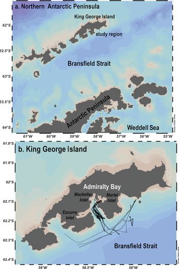
The South Shetland Islands (SSI) consist of 62 islands covering an area of 1250 km2 with jagged periglacial coasts and many bays that are seasonally ice covered, such as King George Island, where Admiralty Bay is located (Fig. 1a). Our study area encompassed a continuous trajectory in Admiralty Bay and its surroundings in the Bransfield Strait (62–63°S and 61–58°W), which is in the north-west zone of the northern Antarctic Peninsula (Kerr et al. Reference Kerr, Mata, Mendes and Secchi2018a). The jagged coast contributes to the formation of numerous glaciers associated with icebergs and outflowing streams discharging to the sea that encircle the SSI. The erosion and particulate matter inputs from glaciers contribute to the complex sea-floor geomorphology and marine habitat heterogeneity of the bays around these islands, supporting a wide variety of benthic and pelagic communities. The southern side of the SSI is separated from the Antarctic Peninsula by the Bransfield Strait, a semi-enclosed sea covering an area of ~50 000 km2 that may be considered a narrow, volcanic and seismically active extensional basin.
The study area surroundings a. in the northern Antarctic Peninsula (King George Island highlighted in b.) and b. the trajectory between Admiralty Bay and Bransfield Strait (see details on the study design in the Materials and methods section). The dashed black line indicates the trajectory of the sea-surface continuous surveys of partial pressure of carbon dioxide (μatm), temperature (°C) and salinity (dimensionless). Plots were created in Ocean Data View (http://odv.awi.de).
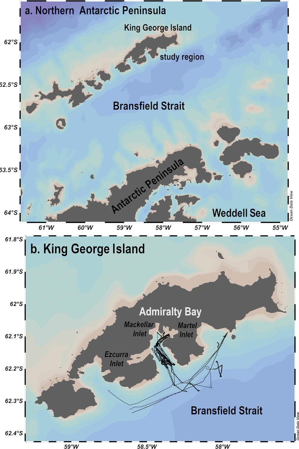
In turn, Admiralty Bay is a fjord-like feature that is ~6 km wide in the centre and 16 km long from south-east to north-west, with glaciers and icefalls that extend for approximately half of its perimeter of ~84 km (Fig. 1b). With rain on snow on King George Island, there has been a decrease in glacier area and thickness in the study area in recent decades. The water melts the snow surface over the glaciers and the meltwater flow penetrates the crevices and connects with both supraglacial and subglacial flows in temperate glaciers, which accelerates the speed of the glacier melt process in summer and changes the mass balance of the glaciers. This bay has three main inlets (i.e. Martel, Mackellar and Ezcurra) and a central channel with steep slopes reaching a maximum depth of 510 m. Both the Mackellar and Martel inlets are strongly affected by glacial erosion, and their bathymetry is characterized by recessional moraines and submarine channels. The central part of the Mackellar Inlet is shallow, ranging from 2 to 40 m, and its bottom is mainly composed of basement rocks, while the Martel Inlet is deep, ranging from 70 to 270 m in the centre. In Admiralty Bay, the distribution of benthic algae is restricted to the 60 m isobaths along the margins and the 90 m isobaths in the centre, a difference that is mainly due to the greater turbidity near the shore, which reduces light reaching the aquatic primary producers in areas with a greater influence from eroded sediments from glaciers.
The subpolar climate of the SSI is characterized by significant seasonal fluctuations, with colder and drier winters and higher annual precipitation and temperatures than those observed in the northern Antarctic Peninsula. The 30 year monthly averages (1983–2013) from the meteorological station at the Brazilian Antarctic Station Comandante Ferraz reveal that air temperatures vary from -5.3 to +1.8°C and that the monthly accumulated precipitation ranges from 36.9 to 43.4 mm in the winter and summer, respectively. This meteorological station is situated along the margins of the Martel Inlet (62°23′S, 58°27′W) and is maintained by the Brazilian National Institute for Space Research (INPE; data available at http://antartica.cptec.inpe.br). In addition, the precipitation throughout the year predominantly falls as snow, but in the summer, an important proportion of liquid precipitation contributes to meltwater and runoff flows that reach the coastal marine areas around the SSI. During the warmer months, the flow of glacial meltwater increases the amount of terrestrial sediment discharges to the subpolar bays in this region. The hydrographic dynamics of Admiralty Bay are complex, as the bay receives contrasting inflows from its surroundings; these inflows are mainly advected from the Bransfield Strait and the continental discharge of glacial meltwater or precipitation over land. Glaciers cover > 90% of King George Island, and fresh meltwater carries sediments, nutrients and organic matter to the sea. Hence, the total organic matter in the sediment of the inner Martel Inlet reaches ~9% and is higher than that of the Bransfield Strait, which may reach only 1% (Masqué et al. Reference Masqué, Sanchez-Cabeza, Bruach, Palacios and Canals2002). The other main source of water to this bay is the adjacent sea, which is more saline and cooler than the continental inputs. Surface seawater in the Bransfield Strait typically has an annual mean temperature of near 1°C and a salinity of 34 (Lopez et al. Reference Lopez, Garcia, Gomis, Rojas, Sospedra and Sánches-Arcilla1999). The Bransfield Strait surface waters result from the mixture of surface waters advected from the adjacent Weddell Sea (~-0.8°C and a salinity of 34.4) and Bellingshausen Sea (2.3°C and a salinity of 33.5).
Materials and methods
Study design
Continuously acquired measurements of sea-surface pCO2, temperature and salinity (depth ~5 m) were associated with a bottom seismic survey and meteorological air temperature and wind speed data aboard the Polar Research Vessel Almirante Maximiano from 7 to 12 December 2013. These measurements were taken following 15 consecutive parallel transects, with a constant low velocity of ~3.0 m s-1, along the thawed portion of Admiralty Bay deeper than 60 m and its surrounding waters in the Bransfield Strait (Fig. 1b). The trajectory of the vessel encompassed three contrasting ice-free zones or ~70% of the total bay area: 1) SHALLOW GLACIER THAW or SG_THAW - the northern area with glaciers along the margins, 2) SHALLOW - the south-western portion without glaciers along the margins, and 3) CENTRE - the deep central part that is greatly influenced by seawaters from the Bransfield Strait.
Discrete medians for surface pCO2, temperature and salinity (25–75% interquartile range) were derived from ~180 measurements taken during 3 min along a transect of ~540 m in each zone (CENTRE, SHALLOW and SG_THAW) of Admiralty Bay (see details on choosing the median instead of the mean in the Statistical analysis section), allowing us to obtain more robust data than any punctual sampling. Then, the whole-bay estimates of these variables were determined using two traditional spatial approaches (i.e. based on the median only for the CENTRE zone and the average of each discrete median for the three zones). Finally, these whole-bay estimates from discrete medians were compared to overall medians determined from the high-resolution spatial approach for each variable (i.e. a 3 m resolution after integrating all measurements - ~2850 during 50 min - taken at 3 m s-1 and 1 min intervals along the transects within Admiralty Bay). The high-resolution spatial median (25–75% interquartile range), determined independently of the classification into zones within the Admiralty Bay, was still compared with its surroundings in the Bransfield Strait, which was in turn derived from ~2350 measurements during 40 min.
Bathymetric data
The high-resolution bathymetry data were acquired using two multi-beam echo sounders: a Simrad EM 3002® (frequency: 300 kHz) for shallow areas and a hull-mounted Konsberg EM 302® (frequency: 30 kHz) for the deep parts of the fjord, continental shelf and upper slope towards the Bransfield Strait. Our data acquisition included depths ranging from 20 to 1200 m. Bathymetric interpretation and grids were performed using CARIS HIPS & SIPS® software.
pCO2 measurements in surface seawater
The pCO2 in the surface seawater was measured continuously using an independent hydraulic system connected to a membrane equilibrator (G542 MiniModule/Liqui-Cel) coupled with a non-dispersive infrared gas analyser (Los Gatos Greenhouse Gas Analyser) in a closed system in the on-board laboratory. The seawater inflow was maintained at a rate of ~2 l min-1 inside the system to obtain a time response of < 1 min (Webb et al. Reference Webb, Maher and Santos2016). The infrared gas analyser was calibrated before and after the sampling period with Air Liquide standards of CO2 in compressed air with nominal concentrations of 200, 500 and 1000 ppm, showing a maximum error of ± 2 ppm in the studied range. The results were expressed as the pCO2 of in situ temperature by converting the CO2 concentration (ppm) to partial pressure (μatm) via multiplication by the atmospheric pressure, and the water temperature was corrected between the sea surface and the membrane equilibrator by the solubility effect, as described by Dickson & Goyet (Reference Dickson and Goyet1994). The water temperature in the membrane equilibrator was measured at its outlet using a PRODO YSI thermometer (precision ± 0.1°C), and the sea-surface temperature (SST) was measured following the methods reported in the Hydrographic and meteorological measurements section. Our measurements were compared with the estimate of the pCO2 value that the water would have at equilibrium with the overlying atmosphere, indicating the CO2 oversaturated or undersaturated waters. We assumed an average equilibrium value of 392 μatm based on recent published estimates for the atmosphere over the Southern Ocean around Antarctica (e.g. Hauri et al. Reference Hauri, Doney, Takahashi, Erickson, Jiang and Ducklow2015) and the 2014–15 data from Palmer Station in the Antarctic Peninsula (available at https://www.esrl.noaa.gov/gmd/dv/data).
Calculation of the meltwater fractions
The meltwater fractions were calculated following Fransson et al. (Reference Fransson, Chierici, Hop, Findlay, Kristiansen and Wold2016) using Eq. (1):
 $${\rm Meltwater}\,{\rm fraction}\;{\rm (}\% {\rm )} = 1\;{\rm -}{\rm S}_{{\rm mean}}/{\rm S}_{{\rm field}}$$
where Smean is the mean annual salinity (33.97) of surface water (~5 m) in areas with an total depth > 400 m in Admiralty Bay and Sfield is the measured salinity in the seawater samples.
Hydrographic and meteorological measurements
In situ and continuous hydrographical and meteorological data were measured as 1 min averages along the vessel trajectory. The SST and salinity were measured using an SBE 21 (thermosalinograph SeaCAT®) calibrated with a precision mercury thermometer. Meteorological parameters (air temperature, atmospheric moisture content, atmospheric pressure at sea level, wind speed at 10 m above sea level and wind direction) were taken from the shipboard online data-acquisition system Vaisala® AWS430, which produced 1 min averages.
Statistical analysis
The pCO2 data, when grouped into classes by temperature and salinity, deviated from the normal distribution (Kolmogorov–Smirnov, P > 0.05) and homogeneity of variance (Bartlett, P > 0.05) assumptions required for parametric analyses, even after transformation. Thus, we used medians and interquartile ranges to represent the distribution of values, and non-parametric tests were conducted to compare the distributions. Statistical differences were tested using the Kruskal-Wallis test followed by Dunn's t-test (significance was defined as P < 0.05). All of the statistical tests were performed using Graph Pad Prism 5.0® software. Consult the supplementary material to see the complete dataset.
Results
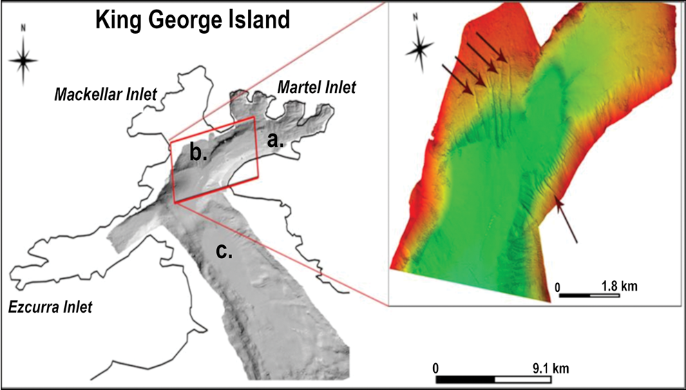
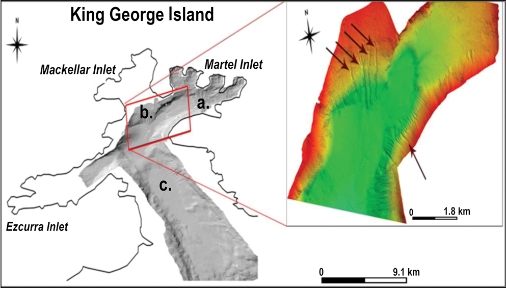
The high-resolution seismic survey indicated distinct bathymetric features within Admiralty Bay, with maximum depths of both shallow zones in Admiralty Bay reaching ~100 m, while the deepest depth in the centre of the bay was 520 m. In turn, the depth of the coastal ocean surrounding the Bransfield Strait was > 1000 m. This seismic survey also revealed a high density of submarine channels in both shallow zones of Admiralty Bay (i.e. SHALLOW and SG_THAW zones; Fig. 2), which was further related to the intra-ecosystem differences in temperature, salinity and pCO2 in the subpolar surface coastal waters studied here.
Submarine meltwater channels identified in the Mackellar and Martel inlets, with dimensions varying from tens of metres to ~1 km long, 10–80 m wide and 2–15 m deep. Distinct bathymetric zones in Admiralty Bay for a. the SG_THAW zone, b. the SHALLOW zone and c. the CENTRE zone.
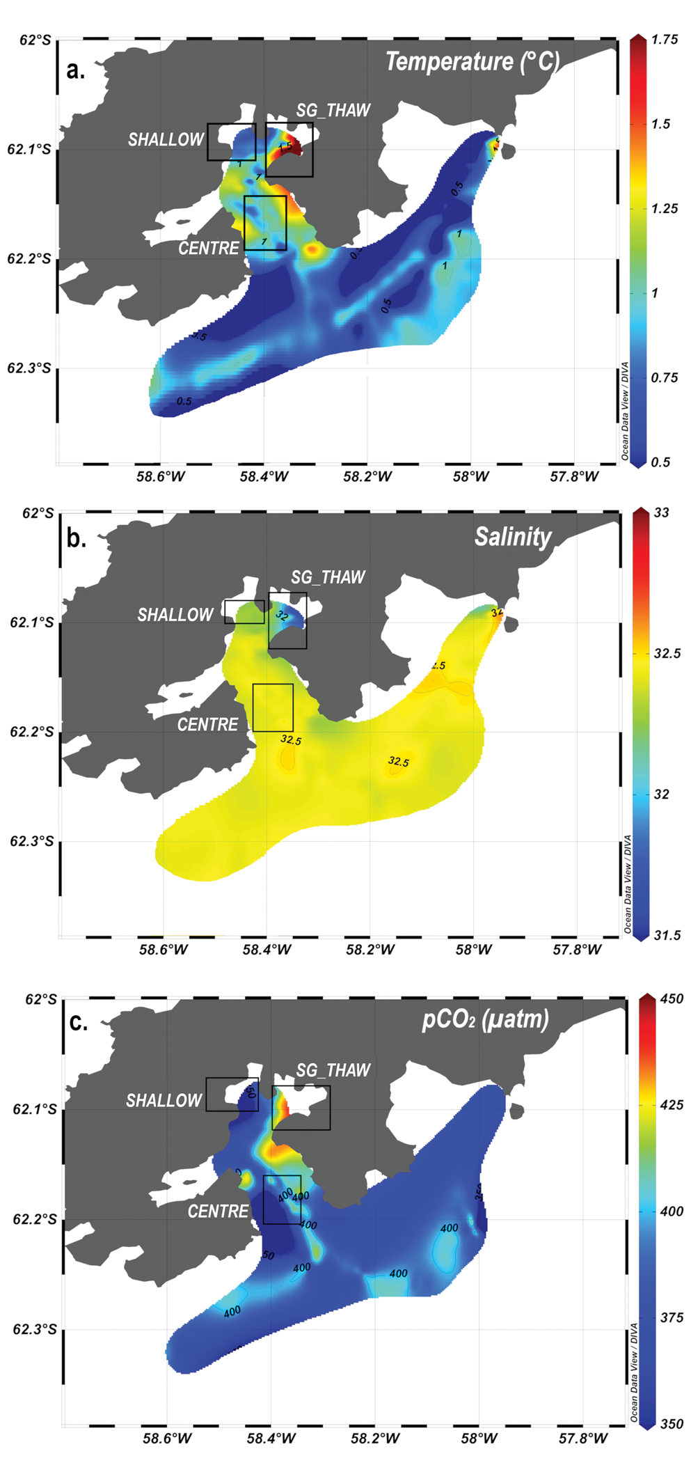
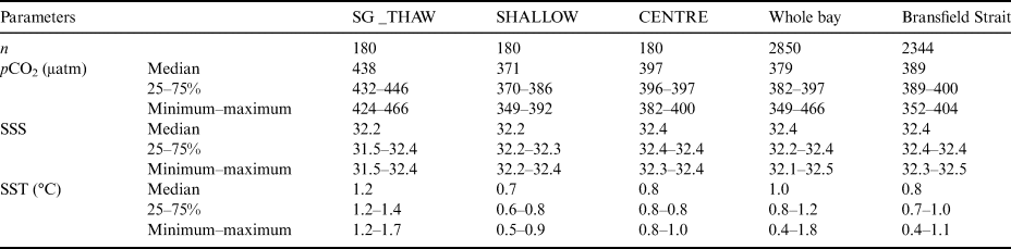
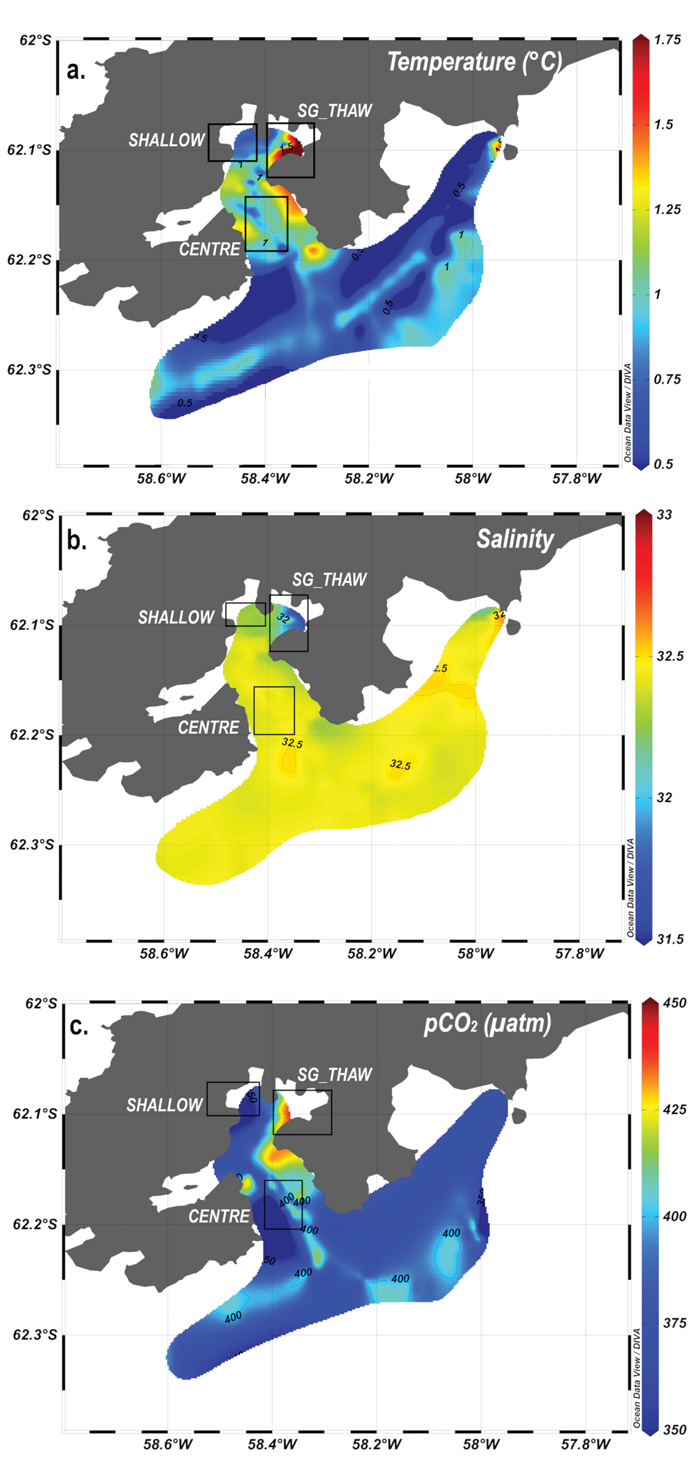
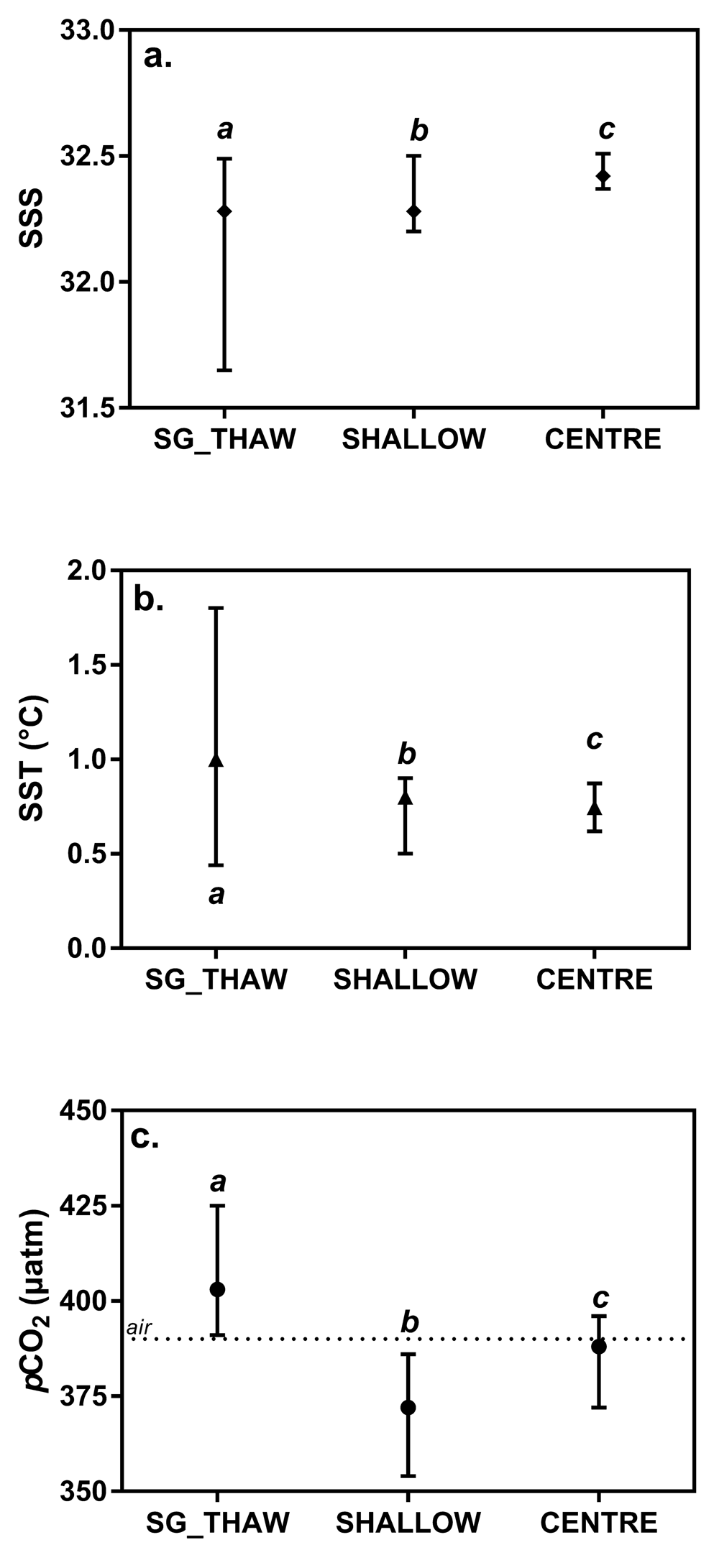
As a result of the percentage of meltwater addition in late spring, the zone of Admiralty Bay with decreased salinity (SG_THAW) reached 6–10%, while the other zones (SHALLOW and CENTRE) were more similar to the Bransfield Strait, with freshwater fractions of ~5–6%. The SST and salinity also varied spatially from the inner inlets of King George Island to their surroundings in the Bransfield Strait (Fig. 3 & Table I). The northern inner portion of Admiralty Bay, with its submarine meltwater channels (i.e. the SG_THAW zone), showed significantly less cold and saline surface water than other regions (Kruskal-Wallis test followed by Dunn's t-test, P < 0.05; Fig. 4). In contrast, the waters of the Bransfield Strait were colder and more saline (Table I).
Sea-surface spatial distribution of a. salinity, b. temperature (°C) and c. partial pressure of carbon dioxide (pCO2, μatm) within Admiralty Bay and its surroundings in the Bransfield Strait during spring 2013. Black squares represent each studied zone within the bay (CENTRE, SHALLOW and SG_THAW; see details in the text).
a. Sea-surface salinity (SSS), b. sea-surface temperature (SST) and c. partial pressure of carbon dioxide (pCO2) for each studied zone. Units are as defined in Fig. 1. Vertical bars show the median with the 25–75% interquartile range. The horizontal dashed line in c. indicates the atmospheric pCO2 equilibrium of 392 μatm (see details in the text). Different letters in each panel represent significant differences among the studied zones (P < 0.05, Kruskal-Wallis followed by Dunn's t-test). Consult the Supplementary Material to see the complete dataset.
Median with interquartile 25–75% of the sea-surface partial pressure of carbon dioxide (pCO2, μatm), sea-surface temperature (SST, °C) and sea-surface salinity (SSS) in the SG_THAW, SHALLOW and CENTRE zones within Admiralty Bay, the whole-bay estimate and the surroundings in the Bransfield Strait (Kruskal–Wallis followed by Dunn's t-test, P < 0.05; details on the study design and statistics are provided in the Materials and methods section).
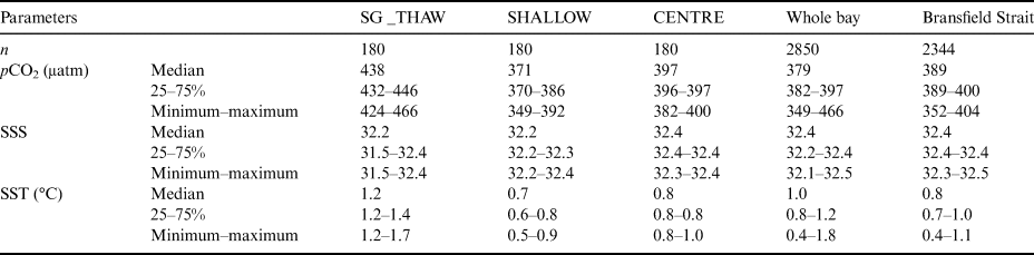
The coastal surface waters in Admiralty Bay and its surroundings showed a spatial distribution of pCO2 ranging from 349 to 428 μatm, with consistently lower and higher values than the atmospheric equilibrium in the SHALLOW and SG_THAW zones, respectively (Figs 3c & 4c). The median (25–75% interquartile range) surface pCO2 showed significant differences among the SHALLOW and SG_THAW zones (Kruskal-Wallis test followed by Dunn's t-test, P < 0.05), reaching 371 (370–386) and 438 (432–446) μatm, respectively.
The whole-bay surface pCO2 values estimated from traditional approaches based on only the median (25–75% interquartile range) observed in the central portion or the average among the medians or interquartile ranges of the three zones within Admiralty Bay were higher than the atmospheric equilibrium of 392 μatm (see details in the Materials and methods section), reaching 397 (396–397) and 402 (399–410) μatm, respectively. In turn, both high-resolution medians (25–75% interquartile range) of pCO2 for the whole bay and its surroundings in the Bransfield Strait were predominantly undersaturated, reaching 379 (349–446) and 389 (349–404) μatm, respectively.
Discussion
Overall, high-resolution data in Admiralty Bay and its surroundings in the Bransfield Strait indicate that such coastal marine waters exhibit median surface pCO2 values below the atmospheric equilibrium (~392 μatm, as explained in the Materials and methods) and thus act as zones of oceanic C uptake during late spring. This CO2 depletion confirms the role of the coastal oceans as a sink for atmospheric C commonly attributed to terrestrial nutrient inputs leading to increased primary production (Duarte & Agustí Reference Duarte and Agustí1998), which has also been observed at high latitudes in eutrophic open-ocean waters off the Antarctic Peninsula (Munro et al. Reference Munro, Lovenduski, Stephens, Newberger, Arrigo and Takahashi2015, Fay et al. Reference Fay, Lovenduski, McKinley, Munro, Sweeney and Gray2018) and coastal areas of the Southern Ocean, especially during warmer months (Jones et al. Reference Jones, Fenton, Meredith, Clargo, Ossebaar and Ducklow2017, Monteiro et al. Reference Monteiro, Kerr, Orselli and Lencina-Avila2020). However, our high-resolution spatial study also revealed a large, previously unknown variability in the net CO2 undersaturation behaviour within Admiralty Bay in the spring (i.e. under seasonal warming after winter), including peaks of surface pCO2 above equilibrium in specific regions.
In the cold coastal waters around the northern Antarctic Peninsula, a highly dynamic spatial variability in surface pCO2 has been associated with shifts from atmospheric CO2 sinks to sources in the Bransfield Strait (Ito et al. Reference Ito, Tavano, Mendes and Garcia2018). Indeed, the dilution effect may largely encompass the thermodynamic effect of temperature increase on pCO2 during the warming season of spring, suggesting that a large part of the spring pCO2 drawdown may be driven by the dilution of brines coupled with the melting of ice crystals as temperature increases (Delille et al. Reference Delille, Vancoppenolle, Geilfus, Tilbrook, Lannuzel and Schoemann2014). Another potential cause of reduced CO2 in these waters during warmer months is the aquatic metabolism, as terrestrial inputs from meltwater typically induce nutrient upwelling that increases biological C uptake by primary producers (Brown & Mote Reference Brown and Mote2009, Tortell et al. Reference Tortell, Bittig, Körtzinger, Jones and Hoppema2015, Fransson et al. Reference Fransson, Chierici, Hop, Findlay, Kristiansen and Wold2016). As a consequence, the observed differences in pCO2 among regions within Admiralty Bay may still be related to depth variations and their direct influence on light attenuation in the water column, considered a main controlling factor on this metabolic gas in aquatic ecosystems (Eveleth et al. Reference Eveleth, Cassar, Sherrell, Ducklow, Meredith and Venables2017, Jones et al. Reference Jones, Fenton, Meredith, Clargo, Ossebaar and Ducklow2017). Previous data during the warming season have indicated that phytoplankton typically determines surface CO2 in deeper waters (Kerr et al. Reference Kerr, Orselli, Lencina-avila, Eidt, Mendes and Cotrim2018b), while submerged benthic primary producers may show an intense C sink capacity in the shallower coastal waters of the Southern Ocean. The lower glacial melt and subsequent input of particulate matter increase the stability of the bottom sediment and reduce the attenuation of solar radiation in waters, which are features that may stimulate the establishment of extensive stands of benthic macroalgae in the shallow areas of Admiralty Bay.
Thus, the low terrestrial meltwater runoff in the SHALLOW zone near Keller Peninsula could be attributed to its ice-free margins, resulting in more saline and colder surface waters, especially in comparison to the shallow glacial thaw zone in the northern region of the bay (i.e. the SG_THAW zone). This result indicates the inactive condition of the submarine channels observed in the SHALLOW zone (i.e. palaeomeltwater channels). This pCO2 disequilibrium below the atmospheric equilibrium and the subsequent CO2 influx rates in the SHALLOW zone were similar or even more intense than those reported in the Atlantic, Pacific and Indian Ocean sectors of the Southern Ocean at ~50°S (Xu et al. Reference Xu, Chen, Chen, Li, Lin and Qi2016) and its portion between South America and the SSI in the Drake Passage (Munro et al. Reference Munro, Lovenduski, Stephens, Newberger, Arrigo and Takahashi2015, Fay et al. Reference Fay, Lovenduski, McKinley, Munro, Sweeney and Gray2018). In addition, our findings confirmed the net CO2 undersaturation observed in the sub-Antarctic Atlantic sector between 50°S and 60°S or in the northern open-sea region of the Bransfield Strait at ~62.5°S during spring (Metzl et al. Reference Metzl, Tilbrook and Poisson1999).
Conversely, higher surface pCO2 values in deeper central parts of Admiralty Bay (i.e. the CENTRE zone) than in shallow inner parts could be attributed to the absence of benthic macroalgae limited by light attenuation and the relatively more intense terrigenous input. In turn, the subsequent increases in sea-air CO2 outgassing observed in the other shallow area (i.e. SG_THAW zone) also contrasted with the net decline in CO2 previously reported in subpolar surface waters less influenced by terrestrial sources and glaciers in the Arctic (Sejr et al. Reference Sejr, Krause-Jensen, Rysgaard, Sørensen, Christensen and Glud2011) or Southern Ocean (Jones et al. Reference Jones, Bakker, Venables and Hardman-Mountford2015) during warmer months. The meltwater inputs from coastal glaciers might have contributed to the higher percentage of additional freshwater and warmer conditions in the SG_THAW zone than in the other areas of Admiralty Bay, which were more similar to the conditions of the Bransfield Strait. Indeed, most parts of this region in the Martel Inlet are surrounded by tidewater glaciers with steep slopes, deep crevasses and fast ice flow. In the ablation areas of this inner zone, the crevasses observed on glacier surfaces are connected to subglacial conduits where meltwater flows downwards to the subglacial zone, while subglacial conduits on the Wanda Glacier emerge at the front of the glacier, and fine sediments are transported towards the Martel Inlet through proglacial channels and lagoons (da Rosa et al. Reference da Rosa, Vieira, Fernandez, Simões and Simões2014). This inner region of Admiralty Bay shows important increases in glacial meltwater flows during warmer months, a dynamic that typically carries solid particles in suspension into the sea. In contrast to other regions without glaciers in the margins of Admiralty Bay, the active meltwater runoff in the Martel Inlet could be associated with inputs from submarine meltwater channels, which were found in our seismic survey, indicating the role of meltwater in controlling surface salinity, temperature and pCO2 in this sampling site, while the smaller channels visible on the slope in front of the Wanda Glacier are probably more recent. In cold coastal waters, a substantial influence from glaciers may reduce autotrophic CO2 uptake due to attenuation of solar radiation by the high turbidity (i.e. from glacial erosion) and increase CO2 enrichments supported by organic matter mineralization or even by direct inputs, such as dissolved inorganic carbon.
Hence, the pCO2 above the atmospheric equilibrium in the SG_THAW region here (432–446 μatm) confirms previous evidence that a substantial influence from glaciers may increase CO2, which has been attributed to light attenuation to autotrophs (i.e. high turbidity) and increased CO2 enrichments supported by organic matter mineralization or even by direct inputs, such as dissolved inorganic carbon from terrestrial sources and upwelling waters (Chierici et al. Reference Chierici, Fransson, Lansard, Miller, Mucci and Shadwick2011). Indeed, the surface CO2 supersaturation in the region of Admiralty Bay nearest the glaciers here is contrary to the strong undersaturation (pCO2 from 119 to 252 μatm) reported in other inner bay area highly affected by meltwater on the coastal ice zone of the western Antarctic Peninsula (Ryder Bay) in summer (Jones et al. Reference Jones, Fenton, Meredith, Clargo, Ossebaar and Ducklow2017). These contrasting results between both inner regions directly influenced by glacial melt suggest the role of deeper depths in Ryder Bay than in Admiralty Bay (~100 and 180 m, respectively). Associated with glacial meltwater and melting sea ice during the warmer seasons, a deeper depth facilitates water column stratification and stability (Venables & Meredith Reference Venables and Meredith2014), which in turn favour algal C uptake in relation to light attenuation and increased CO2 typically caused by vertical mixing (Jones et al. Reference Jones, Fenton, Meredith, Clargo, Ossebaar and Ducklow2017).
To obtain initial estimates of C fluxes to the atmosphere in periglacial coastal waters that are highly neglected in the literature, we calculated the net sea-air CO2 flux in late spring, as reported by Wanninkhof et al. (Reference Wanninkhof2014). The difference between the observed and atmospheric equilibrium pCO2 was multiplied by the Schmidt number, and the CO2 transfer velocity was calculated for intermediate wind speed ranges of 3–15 m s-1, as our median (25–75% interquartile range) here was ~7.8 (6.7–8.0) m s-1. Based on these calculations, the zone dominated by benthic macroalgae (SHALLOW) and the CENTRE zone in Admiralty Bay and its surroundings in the Bransfield Strait became an atmospheric CO2 sink in late spring, with median (25–75% interquartile range) values of -3.4 (-3.4 to –3.1), -1.4 (-1.5 to -1.0) and -0.5 (-1.4 to 1.6) mmol CO2 m-2 day-1, respectively. These results contrasted with CO2 outgassing of +5.8 (+5.0 to +7.0) mmol CO2 m-2 day-1 estimated in the inner area with glaciers along the margins (SG_THAW). The traditional spatial approaches assuming the average of these median sea-air fluxes for the three regions (i.e. without integrating the continuous spatial gradients of the intra-ecosystem heterogeneity; see details in the Study design section) would indicate that Admiralty Bay might be a CO2 source of +2.6 (+1.4 to +5.4) mmol CO2 m-2 day-1 in late spring. On the other hand, more accurate estimates assuming high-resolution spatial heterogeneity (i.e. using all data of the transects in motion; see details in the Study design section) revealed a very slight net atmospheric CO2 sink in Admiralty Bay, with a median (25–75% interquartile range) value of -0.2 (-1.3 to 0.8) mmol CO2 m-2 day-1. This finding indicates that the little-known high-resolution spatial variabilities in imbalances in the net influx or evasion of CO2 in adjacent polar coastal waters to the atmosphere could have important regional implications for any upscaling in the Southern Ocean. In addition, spatially contrasting responses to greenhouse gases could be increasingly important components of global change that need to be better understood, especially during the melting season and in a climate-driven scenario.
Conclusion
Combined high-resolution marine biogeochemical and geophysical approaches were used for the first time in the subpolar waters of the northern Antarctic Peninsula in this study. Our results revealed the great spatial complexity of sea-surface pCO2 along the cold, jagged coast in the warming season. Bays and associated inlets show shallower depths and slower water renewal rates than the open ocean, and these conditions may favour hot spots of both increases and decreases in CO2 in the surface waters. Our findings indicated that high pCO2 values in coastal areas with glaciers along the margins might reduce the overall C sink capacity of cold seawater under warming conditions. The variable distribution of surface pCO2 over short distances along the periglacial waters of the Southern Ocean could be an important, but still poorly understood component of climate change involved in the conversion of large C storage to greenhouse gas outgassing with increasing temperature. The enhanced inputs of organic matter and sediments from the catchment could have profound implications for the C balance in the coastal seas surrounding melting terrestrial environments. In conclusion, depth and diverse meltwater channels from adjacent glaciers may represent spatial controls on pCO2 in cold seawater, a topic that deserves more research to improve predictions of changes in greenhouse gases over extensive periglacial areas of the subpolar coastal ocean in a warmer world.
Acknowledgements
This study contributes to the activities of the Brazilian Antarctic Program (PROANTAR) and Brazilian Ocean Acidification Network (BrOA; https://broa.furg.br). The authors are grateful for the support from the Multi-user Facilities for Greenhouse Gases and Volatile Fuels at the Fluminense Federal University (GAS-UFF) and environmental analysis at the Federal University of Rio de Janeiro (UMAA-UFRJ). We acknowledge L.C. da Cunha, G. Abril and R.B. de Souza for initial discussions and two anonymous reviewers for their improvements to the manuscript. Finally, we thank the Brazilian Navy, especially the crew and all the researchers on-board the Polar Research Vessel Almirante Maximiano for providing logistical and sampling support during the cruise.
Author contributions
LSC and HM conceived and designed the study and wrote the first version of the manuscript. HM, VR, RCGP, FM and AAN performed the measurements on the ship and conducted the chemical analyses in the laboratory. VR organized all of the logistics of the expedition. RCGP carried out statistical analyses and the comparisons of the data with the published literature. All authors discussed the results and contributed to the final manuscript.
Financial support
PROANTAR projects have been funded by and have received logistical support from the Brazilian Ministry of the Environment (MMA), the Brazilian Ministry of Science, Technology, Innovation and Communication (MCTIC) and the Council for Research and Scientific Development of Brazil (CNPq) through grants from the Brazilian National Institute of Science and Technology of Cryosphere (INCT-CRIOSFERA; CNPq grant nos. 573720/2008-8 and 465680/2014-3). In addition, this study was financed in part by the Coordenação de Aperfeiçoamento de Pessoal de Nível Superior - Brasil (CAPES) - Finance Code 001 and the projects CLIMATE-PRINT-CAPES/UFF (88887.310301/2018-00) and FEEDBACKS-PRINT-CAPES/UFF (99997.310301/2018-00). LSC, RV and RK received support from CNPq fellowship 573720/2008-8 and research grant nos. 311380/2019-0 and 304937/2018-5, respectively. HM received support from the Research Support Foundation of the State of Rio de Janeiro (FAPERJ grant nos. E-26/201.503/2014 and E-26/010.001639/2016).
Supplemental material
A supplemental table will be found at https://doi.org/10.1017/S0954102020000334.