Introduction
A significant problem facing the allies in 1944 was the scarcity of oil, the search for which continued throughout the war, especially for oil that was secure from enemy air and submarine attacks. In 1944 the U.S. Navy began exploring in the Naval Petroleum Reserve near the north coast of Alaska. The CULA Expedition of 1944 sent American troops into this remote area. Approximately 400 navy personnel, mostly Seabees (or CBs – construction battalion, Navy personnel who build shore-side facilities, such as roadways, airfields and bases), none with any experience in the Arctic, were disembarked to build a camp and support the first exploratory oil drilling in the Arctic. ‘CULA’ was an arbitrary code name, not an acronym (H. Patch, radioman on CULA, personal communication, January 2013). Of course there were people there already, the inhabitants of the Inupiat Eskimo village of Barrow (MacGinitie Reference MacGinitie1955). On 21 August 1944 one of the expedition's two ships, the liberty ship, SS Jonathan Harrington, ran aground just east of Barrow. In order to lighten itself, some of its fuel was pumped overboard. The heavy fuel oil remained on the sea and beaches in the area for several years. The spill, its circumstances, and sequels provide insights into Arctic operations in Alaska in World War II, evolving relations between American military and the local Inupiat community, and may provide some background into current controversies regarding oil development in the Arctic.
Barrow
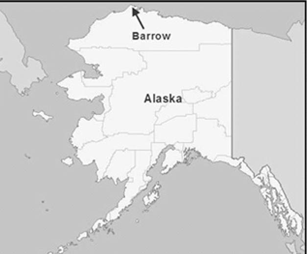
Point Barrow is a geographic point that is the divide between the Chukchi Sea to the west and the Beaufort Sea to the east (Fig. 1). The village of Barrow lies just south of the point. In 1940 the village had 363 residents and in 1950 the village had about 1,000 residents (Jenness Reference Jenness1962: 41). The Naval Arctic Research Laboratory (NARL) was located just north of Barrow. NARL was declared surplus by the Navy in the late 1970’s, but the site is still known locally and labeled on maps as ‘NARL.’
Location of Barrow, Alaska, USA.

Thomas Brower's recollections
The recollections of an Eskimo elder, Thomas P. Brower, Sr., made about 1980.
In 1944 I saw the effects of an oil spill on Arctic wildlife, including the bowhead . . . In August 1944 one of the cargo (Liberty) ships ran aground on a sandbar off Doctor Island at Elson Lagoon, southeast of Utqiagvik [Barrow]. They needed to lighten the ship to get free. To my disgust, instead of bringing up a tanker to transfer the cargo, they simply dumped the oil into the sea. About 25,000 gallons [94 m3] of oil were deliberately spilled into the Beaufort Sea in this operation. In the cold Arctic water, the oil formed a mass several inches thick on top of the water. Both sides of the barrier islands in that area–the Plover Islands–became covered with oil. That first year, I saw a solid mass of oil six (6) to ten (10) inches [15 to 25 cm] thick surrounding the islands. On the seaward side of the islands, a mass of thick oil extended out sixty (60) feet [18 m] from the islands, and the oil slick went much further offshore than that. I observed how seals and birds who swam in the water would be blinded and suffocated by contact with the oil. It took approximately four (4) years for the oil to finally disappear. I have observed that the bowhead whale normally migrates close to these islands in the fall migration. Native families living in the area of Utqiagvik and Elson Lagoon were accustomed to catching small whales in the fall for the winter food supply. But I observed that for four (4) years after that oil spill, the whales made a wide detour out to sea from these islands. Those native families could no longer hunt whales during those years at that location. In my opinion, based on my many years of experience and observation, the proposed drilling activities [this was in about 1980] in the Beaufort Sea threaten the Inupiat with more trouble in hunting the whale and fish and other wildlife because of the noise and oil pollution from the drilling sites. If there were a major blowout, all the Inupiat could be faced with the end of their marine hunting, just as those families near Elson Lagoon suffer(ed) in 1944 through 1948 (Brower, T. 1980).
The spill of 25,000 gallons [82 tons] is not enormous by marine transportation standards. The Exxon Valdez spill, at 40,000 tons, is not even on the list of the 14 largest spills, all over 100,000 tons. Nonetheless, having the spill in an area rich in marine and avian life that had provided subsistence for local peoples was a tragedy to Thomas Brower. Born in 1905, he spent most of his life in a true subsistence environment, in which survival depended on hunting and fishing success. Certainly his comments made in about 1980, 35 years after the incident, indicate anger at the fouling of the food sources upon which he depended.
Navy mission and difficulties: mission
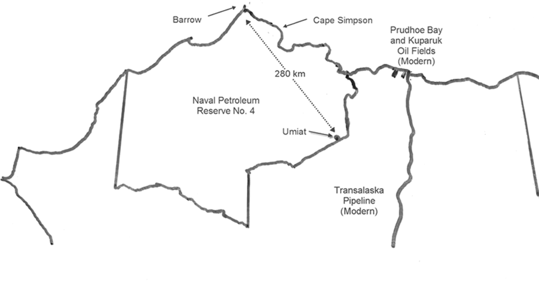
What was the navy doing in Barrow in 1944? The mission was to land troops and equipment to support exploratory drilling in the Naval Petroleum Reserve near the Colville River village of Umiat on the North Slope of Alaska (Fig. 2). The original plan was to sail to Cape Simpson, about 80 km east of Barrow, discharge the cargo, establish the camp, and leave before the ice came back. There is about a two month window in late summer and early autumn when the pack ice is sufficiently far from shore to enable such operations. The region between the main ice pack and the shore frequently has drifting ice flows. In addition, the pack moves in and out with the weather and at the time there were no detailed nautical charts of the area. There were weather records in Barrow, but they indicated that the weather during that time of year was severe and quite variable. The base camp would be established near the beach and it would support overland transport to the village of Umiat in what was then called Navy Petroleum Reserve No. 4 or PET 4.
Barrow, Umiat, and the project location.
During World War I, the navy had experienced shortages of fuel, resulting in a programme of reserving oil bearing lands for the navy. Naval Petroleum Reserve No. 4 was designated in 1923. Large oil seeps had been officially noted in 1917, but were known to the local Inupiat Eskimos long before that (Brower, C.D. 1994). PET 4 covered more than one million hectares. But with the exception of some survey work in 1923 to 1926, not much was done with PET 4 before 1944 (Reed Reference Reed1958).
Ships and documents
Two ships were involved in the 1944 expedition: the U.S. Navy ship, Spica, and the merchant ship, Jonathan Harrington. Commander Francis M. Kiley was captain of Spica and Charles L. Stone was master of Harrington. From Spica the complete but terse deck log (NARA 1944a) and a longer report the captain wrote are available (Kiely 1944). From Harrington the log of the armed guard (NARA1944b) and a ship's log with some brief legal paperwork is all that is available (NAS nd). Near the end of their tour in 1945, the CB Detachment produced a yearbook-style souvenir book of their experiences (Anon. 1945).
USS Spica
Spica, AK16, was an old cargo ship, built for civilian purposes in 1919 and bought by the navy in 1921, but not used until 1940. ‘AK’ was the Navy hull classification system indicating an armed cargo ship. The ship was built as a Hog Islander at the end of WW I. While not ice breakers, this class of ships had hulls with lapped and riveted 1-inch thick plates; thus, had a much stronger hull than the standard cargo ship of the period. Spica had a steam turbine for her main propulsion unit and was capable of 22 kph. She had four holds, two forward and two aft. She was 122 m long and had a 16 m beam with 11,340 tons at 7.3 m draft. Her typical crew was 200 enlisted men and 20 officers, and she could carry 200 passengers (Brooks Reference Brooks2000). Most of her wartime service was in Alaska waters where she participated in the battle for Attu. She made a South Pacific tour that included Kwajalein and in March 1944 returned to Seattle and resumed her work in the Alaska-Aleutian regions.
SS Jonathan Harrington
The Harrington had a crew of 49 civilian merchant sailors, and 21 to 40 naval personnel known as the ‘armed guard’ to operate defensive guns and communications equipment. In addition to the supplies, Harrington carried as passengers 5 naval officers, 14 landing craft operators, 112 CB stevedores, and 61 CBs of CB Detachment 1058. Harrington was a ‘liberty ship,’ one of 2,751 cargo ships built to the same design from 1941 to 1945. Construction of Harrington was started on 11 July 1942 and completed 17 August 1942, just 38 days, which was a little faster than the average time of 42 days for Liberty Ship construction (NPS no date). Harrington (as well as Spica) had only one screw (propeller) and thus no ability to manoeuver if there was damage.
Crew and equipment
Besides their normal ship's company and CBs, the ships transported navy stevedores, who would help with the unloading, but who would not stay on shore. The personnel of CB Detachment 1058 had some people with experience in oil drilling, but not in the Arctic. Early in the war, CBs were limited to volunteers with extensive construction experience. But after December 1942, they were assigned by the selective service system and tended to be much younger (United States 1942). The ships also carried LCMs and self-propelled pontoon barges. The LCM, (for Landing Craft Mechanized), had a flat front that could be lowered allowing equipment to drive off the craft onto the beach. The expedition had a PBY 5A flying boat attached to support the mission, mainly to scout the ice. In addition to the oil equipment, material to build the camp, and supplies for the winter, the ships carried fuel for the vehicles and heating oil in 55 gallon (200l) drums.
The navy stevedores are usually part of the Supply Corps; however, the records indicate these stevedores were ‘CBs’ and they seem to have been directed by line navy officers rather than Supply Corps officers. The commander of the mission and captain of Spica, Commander Kiley, notes there were ‘200 stevedores of the Fifth Special C. B. Detachment’ supporting the idea that these were special stevedores assigned to the CBs and not the Supply Corps.
The voyage north
Spica and Harrington left Tacoma, Washington, on 20 July 1944. Arriving at Kodiak, Alaska, on 25 July, they formed a convoy to Dutch Harbor, Alaska, with six other ships, including three warship escorts. They arrived at Dutch Harbor on 28 July and departed on 30 July. Now just Spica and Harrington sailed north and arrived at Point Hope on 2 August. There the PBY met them. While there, the ships had to transfer gasoline to the PBY. They did this by moving the gasoline in five gallon (19l) ‘blitz cans’ via a small barge. Then the cans needed to be carried over a spit to the lagoon, where the PBY was moored. ‘The natives were glad to help. . . . This was especially true after we generously distributed candy, gum, and various other ships service edibles to the very receptive and eager hands on the beach. Good-will and assistance thereafter was assured.’ Also, the ship's doctor was asked by the local people to attend to two sick, which he did (Kiely 1944: 5).
Cape Simpson attempt
On 3 August they encountered the first ice. Initially they faced small floes, then heavier ice, and then fog. They arrived off Barrow on 4 August and anchored on the west side, since the ice was in on the east. Their destination was Cape Simpson, about 80 km east of Barrow. After finding their way through the ice they anchored off Cape Simpson on the evening of 6 August, where they stayed for several days, sending out survey parties to check for routes to the beach. The water here was about 9 to 10.5 m deep, while the ships’ drafts were 7.5 m. While the area near Cape Simpson was closer to the petroleum area, the landing site was not suitable. ‘All parties agreed on the impossibility of landing and erecting camp in that area. The land was low, only a few feet above the ocean, and dotted with lakes and covered with swampy tundra. Poor drainage prevailed, landing strips would have been impossible in the summer and the unloading itself a near physical impossibility’ (Keily 1944: 9). The water was too shallow, only 0.6 m deep, up to 0.4 km from the shore.
Cape Simpson was completely unsuitable for a camp. But six days were wasted exploring this option. While at Simpson, drifting ice, pack ice, snow storms, fog and high winds, greater than 48 kph at times, hindered exploration. By 10 August it was decided to investigate Point Barrow. At that time the west side of the point [where the ships had come through the week before] was packed with ice, but the east side was fairly clear. Since the side of the point that was packed with ice would vary with the wind, the decision was made to find a camp on the point (or spit) so that if the wind changed, they could sail to the other side and thus avoid the pack ice.
Barrow landings
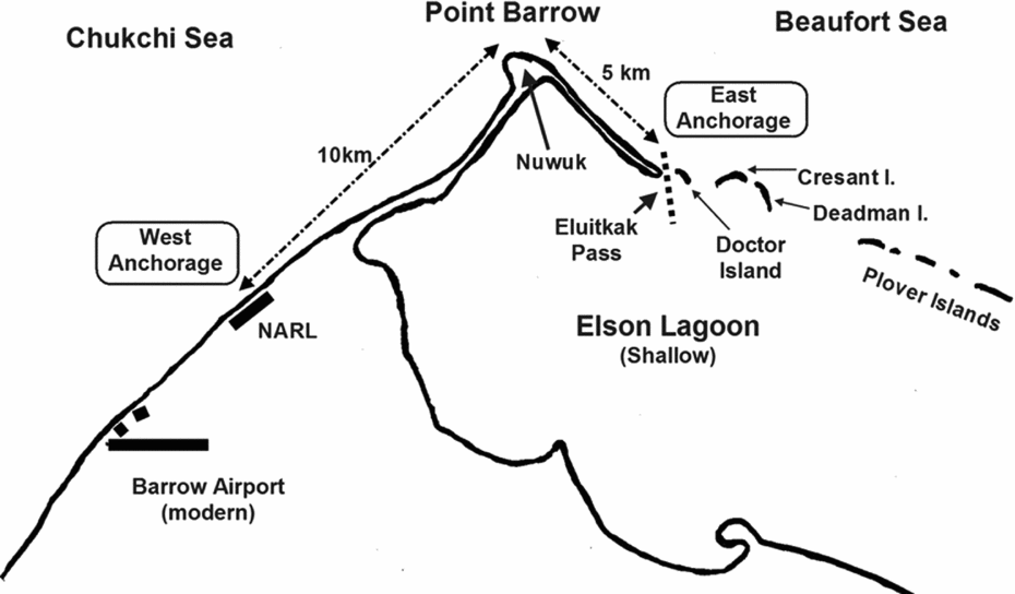
On 11 August both ships returned to the Barrow area and continued to ‘send out survey parties to sound waters and look over landing beach’, which was necessary, since there were no charts. The logs show that Spica started discharging cargo 12 August while it was anchored off the northeast side of Point Barrow. This beach is called Nuwuk, after the name of the abandoned village site on the point. There were no docks or unloading facilities. The ships were unloaded by lightering. Fuel wes transported in 55 gallon (200l) drums and unloaded in cargo nets onto barges for the trip to the beach. Once ashore, the cargo was manhandled off the beach to higher ground. The plan evolved that the final site of the camp would be the site that is today known as NARL, but unloading would take place at the Nuwuk site, for later transport to NARL (See Fig. 3 for locations).
Locations near Barrow.
Factors affecting the ships and unloading
In this section we summarise the weather and incidents leading up to the spill. This section is paraphrased from Keily (1944) with direct quotation of relevant items. The author's comments are in brackets.
10 to 20 August – Begin unloading
10 August. Sailed [from Cape Simpson Area] in the direction of Point Barrow or Nuwuk. The ice pack was solid here and it was decided not to go any further west. [sent out survey party] the ice pack was quite thick around us and it was constantly necessary to manoeuver the ship at anchorage to avoid the bigger bergs. [They explored the east-west spit from Nuwuk to Eluitkak Pass] looking for deeper water close to shore.
11August. [Proceeding slowly, sent out survey parties.] All this time the ice pack was still heavy against the shore on the western side of the point, extending down to below the village of Barrow. It was impossible for the ships to get around the point and to proceed down along the western coast line. [This of course means that the ships were trapped against the north coast.]
12 August. Found a good beach [Nuwuk] for unloading, with sufficient water to float the ships, only one and quarter mile from shore. But when they unloaded two jeeps using the LCMs, they found the jeeps bogged down in the loose gravel on the beach. The beach on the west side [NARL], closer to Barrow, was better for a camp, but the ice was still packed in that area. [They decided to land what they could at Nuwuk.] The NARL site was considered the only feasible site in the area for the camp, but the ice was still packed in. So, they commenced to unload on east beach, since there were no weather forecasts, and ‘any further delay in discharging operations might result in the failure of the expedition, and. . . .it was better to have cargo landed then on the ships.’ [And it would be possible to move the cargo by cats (bulldozers) and sleds after freeze up].
13 August. Unloading operations 24 hours per day. Winds and seas were calm, but now a thick fog made the trip between ships and shore hazardous. ‘The [Spica’s] whistle was blown at regular intervals to guide them back to the ships.’ [What happened if the returning LCM or barges missed Spica? Above the captain says they found a place 2 km from the beach, which he meant the thin east-west spit, but this author's analysis of the logs show it was almost three miles to the landing beach at Nuwuk. Also, they went to six hour shifts, which means six hours on and six off continuously day in day out] and ‘this allowed all feeding to be done on the ships with no loss of time.’ But even here, ‘During a greater part of this day the ship had to be manoeuvered with engines to avoid the larger ice flows floating by and to afford protection for the barges unloading cargo. . . .’
14 August. Weather worsened, wind increased to 37 kph and sea became choppy and the large amount of drift ice made it necessary to maneuver the ship. However by evening the wind caused the ice to clear from the west side of point, so that the LCM could be sent all the way to the NARL site, although the ice was too close to send the ships there. [Note this is a much longer trip for the LCMs, about 16 km one way.] And still, ‘Fog impeded the unloading operations and the whistle had to be sounded at short intervals to guide boats. It was dangerous work for the LCMs and barges in the ice and fog. . . .the longer trip made operations somewhat slower and dangerous for personnel.’
15 August. ‘Fog continued to hamper the operation. The winds remained southwest but increased in gusts up to thirty-two knots [59 kph]. Intermittent rain did not help matters. . .’ but the ice continued to move away from the west beach.
16 August. ‘In the early morning the weather became very miserable. . . .a continuous fog and heavy mist cut the visibility down to a few hundred yards. The ice pack moved in swiftly again from the northwest’ [closing the channel to the NARL beach.] Wind increased to 55 kph continuously, sea too rough. Some of the LCMs got caught on the west side by the ice and could not be moved back to the ship. [Again, that means the relatively small boats could be pushed by the ice onto shore, at best, or crushed.] Also on 16 August, the PBY sank during the storm. The plane was moored in Elson Lagoon and the aircrew was on the ship getting a meal; the cause of the sinking is unknown.
17 August. Wind ‘died down to fifteen knots [28 kph].’
18 August. Seas calmed and unloading speeded up. However ice was still too close on the west, so ship remained on the east side, requiring the long trip to the beach.
19 August. Still cannot get around point. LCMs and motor barges needed repair.
20 August. Ice cleared enough for the ships to go around the point, although ‘there was still some pack ice on the beach and some floating bergs, but it was considered safe.’ So at 1655 they hove up anchor and at 1918 anchored about 1.6 km off the NARL site. But ‘discharging continued favorable under conditions of heavy fog and rain.’ At the end of this day, Spica discharge was about 95% completed and Harrington was 75% completed. [As unloading progressed, they were able to erect some small cranes on barges and the beach, which could unload directly into athey wagons – wagons with tracks rather than wheels. The athey wagons were then towed with cats. Heavy cargo could then be unloaded quicker, but if it was unloaded on the Nuwuk beach, it still had to move about six miles in soft sand and gravel to the NARL site.]
Events of 21 August – storm
21 August. The day started well, but about noon, ‘The wind began to increase and discharge became slower. By 1600 the wind had increased to thirty knots [55 kph] and showed signs of going higher. Boats were sent around the point [back to the east side] to avoid the wind and seas. The wind had now increased to over thirty five knots [65 kph] and the seas in this shallow water were very high.’ [Some barges were sent around the point successfully but], ‘the remaining barges beached and were then pounded heavily by the seas. The cargo of one barge was lost completely, but the men were successfully rescued. Orders were given to direct the boats and barges for the best protection of the men. In the storm twenty five men had been washed overboard from the various boats, natives helped in their rescue.’
The preceding is from Spica log (Keily 1944). A separate section of that log is a report that was written by the ship's officers that were on shore, Coste, Holmgren, and Bowman, and discusses the detail of the beach operations. They note that on the storm of 21 August, when the LCMs and barges were sent around the point to shelter, one LCM lost its engine and beached. When the navy rescue party reached them, ‘it was learned that a group of Eskimos was responsible for saving the two operators of the barge. One of the Eskimos had a small heaving line with him. This he passed to the barge where a large line was then hauled ashore. The men then pulled themselves ashore safely on this line. The Eskimos were taking the men to their hunting camp to dry them out and to give them hot tea. Also: ‘All together more than thirty-six men were treated for exposure and shock.’ The medical supplies ashore were very meager but luckily there was a ‘sufficient supply of APC tablets and sulfa pills. The men were put to bed in sleeping bags.’ [Of course the sleeping bags were good, but the APC is just glorified aspirin and the sulfa pills are an antibiotic. Neither would have much effect on exposure-related stress.]
The bulk of the oil drums on the stranded barges spilled from them and were washed in along the beach. Around 500 drums were washed from the barges to the beach. The beach was strewn with oil drums from the [NARL] beach to the tip of Point Barrow. All of these oil drums were recovered later and carted to the NARL beach. [These drums weigh about 180 kg each – recovery of these from the surf and transport of these on the beach must have been an ordeal.]
Events of 22 August – the spill
[To review the situation so far. The ships were on the west side of the point, the LCMs and some of the pontoon barges were out of service. Approximately 30 men were on shore suffering from exposure, and the winds were Force 7 or 51 to 60 kph.] Then at 2124 hours on 21 August, ‘it was decided that the only thing for the ships safety was for them to go around the point to the east. The ice pack was coming in very fast and had already blocked off the channel to the south. No small boat could weather the storm now in its fury so we could not send a sounding boat out ahead, as we had done in coming down.’ But they followed their former course as best they could. They got near where they had anchored before and, ‘The wind was still high and the visibility was continually cut by snow flurries and in between bearing could be obtained no known tangents on the beach to ascertain our position.’ [This can be interpreted to mean that the visibility was too poor to see landmarks on shore since their last anchorage in that location.]
Then at 2055, Harrington went aground. She got off, but soon grounded again. This time she would not come off. Spica, which had unloaded more cargo, might have helped but, ‘Snow flurries and the strong wind did not allow an attempt to tow her off at present.’ [Harrington was 78% discharged, so there was some weight that could still be removed. Spica's logs indicate it was in about 8.2 m of water, and this author, triangulating from the logs, plotted its location similarly indicating the same depth, if the modern charts are correct. Based on Spica's log, which had a bearing on Harrington, she may have been in 5.5 m of water. Although a fully loaded liberty ship drew 8.2 m of water, Harrington had been discharging cargo for 10 days. Today there are charts that indicate the water depth, and surveys of the area that indicate there are many east-west trending bars along that shore (Short 1974). Such data was not available until the oil exploration almost 20 years later.]
22 August. The storm abated, but the wind continued from the west southwest and the west side of the point, where the ships had been anchored the day before, was now completely iced. The ice on the east side of the point where the ships lay at anchor was ‘at first two and half miles from the ships, but kept coming closer all day. Spica sent boats to help Harrington. They took Harrington's anchors out ahead and also Spica lent an anchor that the Harrington could use to keep her stern from floating higher on the shoal. Besides pulling on the anchors, Harrington kept her engines turning. Meanwhile they used small boats to take soundings all around. A plan was made to use Spica to pull Harrington off, but ‘both ships were in floating ice and this would have proven difficult.’ Meanwhile Harrington continued to unload as she could, with the few barges available. ‘Ice continued to come in all day very slowly and by evening it surrounded both ships. This also hampered the rescue operations of Harrington in the last successful efforts. Boats found it hard to come alongside her to continue the discharge of cargo [which would have lightened the ship more]. So ‘she also began to pump fuel oil over the side to aid in lightening the ship. At 2328 Harrington came off the shoal. She had discharged sixteen hundred barrels [254 cu. m] of oil.’
The available records do not have an official record of how much oil the Harrington had on board when it pumped. Simple calculations indicate that the Harrington may have been able to pump up to 100,000 gallons and still have a reserve to get back to Dutch Harbor. In any case, the captain would not have pumped any more oil than required in order to get free. Grounding is an embarrassment for a ship's master, but not so much of an embarrassment as is running out of fuel. Presumably the pumping was a last resort and the captain would have pumped the minimum required to free the ship. Harrington was in shallow water and Spica might have risked running aground if necessary to save the Harrington from being crushed by ice, but it seems unlikely they would have done so to act simply as a tank. In any case, pumping Bunker C oil at sea was a complex operation, since it had to be heated. In those days marine oil pollution was not given the importance it has today. Also, ice had been coming in and out and a stranded ship was at risk of being damaged by the ice.
22 August to 2 September. Wind-up of unloading and depart
Following the freeing of Harrington, the ships moved to deeper water and operations continued unloading and transporting to the Nuwuk site where material could be ‘taken by wagons’ to the NARL beach. Some of the LCMs and barges were still iced in on the west beach and ‘it was known that some of these were in bad conditions.’ Finally, ‘ice continued to come in all day very slowly and by evening it surrounded both ships.’
[The end of a long day], ‘At 2130 three hurt and sick men were brought from the beach and were immediately treated by the ship's doctor and admitted to sick bay.’ They were some of the 25 men who had been exposed to the water and cold, the day before, and had been injured in the storm.
23 August. ‘Continued to discharge on north side at Nuwuk, but the storm had caused the sand to shift and now there was only a few inches [5 cm] of water 25 to 30 feet [7.6 to 9.1 m] from the beach, which made mechanized unloading difficult.’ But, at 1700, ‘The officers and men of the C.B. Detachment 1058 were transferred to the beach and they took up their base of operations there.’ This log entry probably means the commander of the unit moved his headquarters. The logs show that the CB detachment, the stevedores, some of the ship's company from both ships and the armed guard from Harrington, all helped with the unloading.
The ships leave
Nothing was easy for the ships, but they did unload all the supplies. On 26 August Harrington was completely discharged. Some of the injured men who could travel were transferred to Harrington so they could be taken to the hospital in Dutch Harbor. After one false start, when Harrington was blocked by ice and came back, finally with the help of a PBY (a replacement for the one that sunk) to guide her through the ice, she left. Spica and stevedores stayed, since there was a lot of work to be done to transfer the equipment and supplies from the Nuwuk beach to the NARL. Between 23 and 31 August Spica moved up and down the coast in response to ice. Finally on 31 August the pack ice moved to within 1,500 yards. ‘The wind had increased to 40 knots [74 kph]. We then encountered the main pack ahead with continuous floes which we could not get around. We had to push our way through the floes using varying speeds ahead and astern. Snow storms and fog reduce the visibility at times to zero. The velocity of the wind makes the snow come in a horizontal direction. The fact that the ship was light made the screw [propeller] project out of the water about eighteen inches and the vessel answered the rudder badly.’ At the times the ice was on all sides and it was dangerous to stop but then the screw could hit the ice and damage it. Finally it was impossible to get back to the beach. ‘Seventy six men were left of the beach; including stevedores, plane crew, ship's company, and LCM crews.’ These men were left behind and transported after the heavy moving was complete.
All the night of 31 August Spica continued to manoeuver. The crew noticed that one of their fresh water tanks was salty, indicating damage to the hull. Finally they stopped and lay drifting in the ice pack. By 1 September, they were drifting with the ice, but radar indicated they were drifting toward shore. Finally, 2 September, the ice thinned out and they were able to get underway. When they were clear of the ice a few days later, they inspected the ship and found: ‘stem (bow) bent aft from about four feet [1.2m] above the keel to about 12 feet [3.6 m] above keel. Shell plating damaged, port side, from stem to frame 26; most damage about eight feet above keel; leaks through loose rivets in peak tanks, port magazine, port side of handling room, and port side of number one hold. Frames (ribs) numbers 3, 4, and 5 badly bent and twisted with several rivets broken.’
Sequel
The oil and what happened to it?
Liberty ships burned Bunker C, a heavy oil also known as ‘black oil.’ It is normally heated by steam coils in the fuel tanks for distribution to the ships’ boilers. The ships had piping and valves that allowed them to pump fuel overboard in an emergency, to lighten the ship or to reduce wave action in a rescue at sea (M. Schneider, Chairman Project Liberty Ship, personal communication, August 2009). Bunker C does not disperse well naturally and there are modern incidents in which it has remained on beaches for years. Bunker C from a 1970 spill remained on a beach in Nova Scotia for more than 30 years (Fingas Reference Fingas2004). On rough water it will form an emulsion that greatly expands its volume.
Where did the oil go?
From the logs, the author reconstructed the locations of Spica and Harrington and the wind direction on 22 August 1944. Although the incident is known as the ‘Doctor Island spill,’ it seems unlikely that the oil initially hit that island. The wind was blowing from the west, which would have pushed the slick toward Crescent Island or Deadmans Island which lay to the east of Harrington. The spit that runs from Point Barrow to the east, and the islands mentioned, are a barrier beach system collectively known as the ‘Plover Islands’ that lies between Elson Lagoon and the Beaufort Sea. Surface slicks generally are pushed in the direction of the wind. Certainly these winds that were blowing up to 38 kph would have had a powerful effect. The currents on that coast outside the barrier islands generally flow from east to west, however they are not constant and often reverse, usually with the wind. Thus, it is unlikely that the eastward push of the slick would have been prevented by the current.
Generally, the flow of water is out of Elson Lagoon toward the sea. However this direction is also not constant. While the tides in the area are small, perhaps 0.3 m or less, the wind can push a storm surge up to 1 m. Thus, current may flow into the lagoon. However the winds on 22 August were blowing west to east and would not support a storm surge into the lagoon. Thus the location of Harrington, deck logs of Spica with the reports of wind speed and direction, and the standard oceanography of the area indicate that the initial movement of the oil was eastward along the ocean side of the barrier beaches.
On the afternoon of 22 August, about the time Spica reported that Harrington was afloat, the wind changed and began coming from the northwest, although not as strong as earlier, and this wind continued for the next two days. Thus the wind may have pushed the slick through any of the several shallow channels along the barrier beach. Around noon on 25 August, the winds changed to a more easterly direction that persisted for several days. Thus, if the slick was not grounded, it could have moved back toward Doctor Island and Eluitkak Pass. A computer model of the spill based on wind information from the ships logs indicates that most of the oil would have impacted Crescent and Deadmans Island, with some entering the lagoon, and after the change in wind direction, some oil would ground on the lagoon-side of the spit and the barrier islands (Amy MacFadyen, NOAA Spill Response Center, personal communication, 14 December 2011).
Based on the logs, the most likely locations where the oil would have met the beach are the north side of Crescent and Deadmans Island. The author conducted an investigation in September 2010, boring over 50 holes on beaches of Crescent, Deadmans and Doctor Islands and found no trace of the oil. Although Bunker C can remain a long time on firm rock beaches above the usual high tide line, it is not surprising that none was to be found on the sandy barrier islands as these islands move. There is a steady migration of the barrier islands towards the west; some reports have movements up to 70 m in the average year (Short and others 1974). Hence, a section of the ‘beach’ from 70 years ago could be almost 5 kilometers further west. As the sand moves west it would eventually find its way into the northward currents from the west side of the Barrow Spit and finally into deeper waters to the north.
Harrington's woes
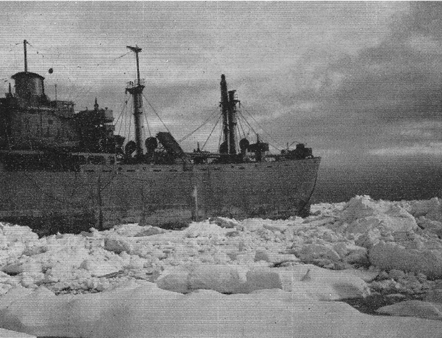
Harrington had problems on this voyage. A collision with a ship in Dutch Harbor at the beginning of the voyage, a fire in a hold off Barrow, two groundings, the one discussed above and another as the ship left Kodiak on the return voyage. There were many injuries to personnel; the more serious were taken to Spica where there was a doctor and were noted in the log. Besides the exposure, most injuries were from the loading and stevedore operations. Accidents, such as a 2.5-cm cable parting, caused injuries such as sprained backs, sprained and broken ankles and other injuries severe enough to warrant admission to Spica's sick bay. Clearly the unloading accidents were understandable, given the mission and the hurry to unload before the ice closed in. Handling the 55 gallon [200l] fuel drums was an ordeal. They each weighed about 180 kg and were unloaded with cargo nets onto barges. The edges of the net were lowered and stevedores lifted the barrels upright, then rolled them into order, and then received another net, etc. All this was done in waves up to one meter and often with 32 or 48 kph winds and snow or fog. Larger boxes were dragged off the LCMs or barges with cats. All those operations took place in the surf, on the soft beach, or both. Available records do not say much about the master of Harrington. The record of the armed guard does not disparage him in any way. Most of the injuries were to stevedores, who were navy troops not directly under his command. Also, although the master was in command of the ship and responsible for all aspects of the voyage, the actual duties were discharged by his mates, and the mates were young. The same master, Charles L. Stone, commanded Harrington on its voyage to Barrow the following year (NAS nd), implying his services were deemed satisfactory (See Fig. 4).
Harrington’s troubles did not end in 1944. She returned in 1945, this time she was stuck in the ice. Photo U.S.Navy from Reed, 1958.
Native people and the navy
Researching the events of the spill and its aftermath indicates the evolution of relations between the Inupiat Eskimos and the naval personnel. Certainly dumping oil on the local food source warranted an apology to the Barrow people, but there is no record of that. It seems likely that if the navy had made an effort to reconcile the locals about the spill, Thomas Brower would have mentioned that. It is clear that with the oil dissipating in 1945 and later, relations between the natives and the navy personnel, and mutual respect, increased.
Gathering respect for the Inupiat
The CB yearbook (Anon. 1945) does not mention the Barrow people except in one small passage that could be taken as disparaging them. Although the book has pictures of the people and their lifestyles, it does not have names of the people or notes about the pictures. Could it have been that, although Alaska natives participated bravely in the war effort as scouts and guards in the Aleutians and southwest Alaska, there may have been a lack of communication between the local people and the CBs? Of course the logs and reports follow a very formal format and would have downplayed any personal relations (and, of course, commonly troops are discouraged from fraternising with the local residents, since troops may overwhelm the existing social structure). Jim Sours, the managing editor of the CB yearbook, who was one of the expedition members who spent the winter after the ships left, in an interview 40 years later, had this to say: ‘When we got up there, the clothing was all wrong. They gave us stocking masks that would freeze to your cheeks. It took about three months to get that squared away. They finally bought mukluks (fur-lined snow boots) from the Eskimos.’ The navy personnel also learned about survival from the Eskimo people. ‘They wear four or five layers of thin clothing,’ he said. “You get air in between those layers and it provides great insulation. It was a lot smarter than what we were wearing.’ They also learned to adjust to temperatures that dropped beyond 50 degrees below zero [– 45 C]. Sours learned to appreciate some native food, the boiled polar bear and raw whale notwithstanding. ‘The next time I tried muktuk (raw whale), this Eskimo lady had prepared some type of hot oil sauce,’ he said. ‘Tasted . . . like coconut. You dip the muktuk in there and it isn't bad at all’ (Mail Tribune (Ashland OR) 4 January 2002). So, presumably in the winter, after the frenzy of the unloading and setting up the camp, the CBs did have some friendly relations with the locals.
Navy recommends Inupiat technology
Even the official records indicate a trend in the interaction. At Point Hope on the voyage northward the captain's log is condescending, implying that some candy was sufficient to purchase friendship and hard work from the Eskimo. Later, after the rescues on 21 August, the appreciation in the log book can be noted. Finally, based on his experiences, the captain of Spica wrote a supplement to his log titled, ‘experiences and observations on the ‘CULA’ expedition.’ It has information specific to navigation in the Arctic, but a section that demonstrates the relations with the local people was as follows:
Equipment Required: Based on the advice of people who have had much experience in the Arctic region, the following recommendations are made:
1. A sufficient number of fawn skin shirts and pants,
2. At least two pairs of mukluks for each man of the winter party,
3. Fur mittens for all hands also wool mittens,
4. Adequate number of snow glasses,
5. Acquire at least one reindeer parka for each member of the winter party,
6. One pair of sealskin pants for each member of the winter party.
7. Acquire enough tanned polar bear fur or wolverine to sew around hoods of parkas to protect men's faces in case the issued parka coats are to be used.
8. Necessary number of fur socks to be worn inside mukluks,
9. At least three dozen pairs of skis with binding and suitable shoes.
10. An adequate number of trail stakes with orange bunting.
11. Two good dog teams with sleds’ and spares,
Arrange for two Umicks (skinboats) with outboard motor.
. . . . Arrange to have a couple of native families to stay in vicinity of camps during the winter and have their women repair footgear for expedition members. This is very important. . . .Skinboats should be handy for rescue work in the ice; also dog teams and sleds (Keily 1944).
So the captain of Spica moved from a view of buying labour with candy to a more progressive view of endorsing the natives’ equipment and implying that they would be the best to repair the Arctic clothing the troops needed.
Inupiat as skilled labour
Regarding their value as skilled labour, there is a likewise progression. For example, in the spring of 1944, before the CULA expedition was approved, a preliminary scouting mission went to the area and reviewed the situation. It made recommendations, one of which stated: ‘7. Because of the prevalence of tuberculosis and the undependability of the natives as steady workers, no consideration should be given the procurement of local labor’ (Reed Reference Reed1958: 22). But by 1953, the project had hired many natives and the final report on the project notes among the achievements of the project ‘close relations with the native Eskimos and their maximum use in the project’ (Reed Reference Reed1958: 174). In 1954, when the oil project ceased, 125 Eskimo men were employed at $140/ week (Saturday Evening Post (Philadelphia, PA) 20 February 1954: 88–94), which is $1184/wk in 2011 dollars.
Native health
Besides cultural differences, health may have played a role in relations. In early and middle 20th century United States, tuberculosis (TB) was a dreaded disease, often associated with poverty. In 1946, a contractor reported, ‘An attempt was made to employ Eskimos applying for work, but TB among them was very common and only 13 were found physically fit – they were employed’ (Reed Reference Reed1958: 49). A 1937 survey found 25% of the Eskimos suffered from TB (Jenness Reference Jenness1962: 33). Simple influenza was also a problem since natives often did not have resistance. ‘A serious influenza epidemic struck the native village in February 1945 – Eskimos are especially susceptible to such communicable diseases. At one time almost all of the inhabitants of Barrow were ill. The Navy assisted..[with] surplus food and distributed oil for [the] hospital and [the] medical officer contributed his personal services unstintingly’ (Reed Reference Reed1958: 46). As antibiotics and other treatments for TB became available and natives began to acquire antibodies for flu, they became more available for work.
Possible problems with alcohol may have complicated relations between the Navy and the local Eskimos. The original Organic Act of 1884 banned the importation or sale of alcoholic beverages (Jenness Reference Jenness1962: 8). However Charles Brower reports the locals had learned how to distill spirits, although they needed flour and sugar to do so (Brower, C.D. 1994). Jenness suggests that for the natives in a barter economy, acquisition of alcohol was too expensive (Jenness Reference Jenness1962: 48, 49). However the military bases made both cash and alcohol available, to the severe detriment of the people. Of course Brower was writing about times before about 1930, while Jenness may have been referring to the DEW line (Distant Early Warning – a system of remote radar stations) and other military activities of the early 1950’s. None of the records regarding CULA and that era mention alcohol.
Oil development, past, present, and future
The oil field near Umiat was not developed, nor was any other large field in PET 4, which is today known as NPR-A, the National Petroleum Reserve – Alaska. There was oil, but extracting it was not economical with the technology available. Also, to exploit the oil, a pipeline would be needed between PET 4 and Fairbanks to the south. Some of the natural gas was developed and today this powers Barrow. There was a second CULA expedition in August 1945 with three ships, again Spica and Harrington, and a third cargo ship. In 1946 the navy personnel were withdrawn and the fieldwork turned over to a civilian contractor. There were supply convoys to Barrow, known as Barex 47, Barex 48, etc. Most were larger than the CULA expeditions. Then in 1953 the navy shut down the drilling project. Fortunately for Barrow, the former CB camp and oil project site had been moved to NARL in 1947. The Office of Naval Research had been funding the site for its own research and making it available to other research organisations. Also the DEW line started in late 1954, and the construction of radar stations in the Arctic helped the local economy.
The navy started to disengage from NARL in the early 1970s because its geographic interests had shifted and because the NARL site was being used by many other agencies. With the oil crisis in the mid-1970s, the base continued to support outer continental shelf activities. However in 1977 the navy cut off funds and asked that all activities at NARL be self-supporting. In the late 1980s, after a long transition, ownership of the site was given to Ukpeagvik Inupiat Corporation (UIC), the village corporation for Barrow natives. Today it is a multiple-use facility (Kelly and Brower 2001: 259–264).
In the 1960s, a huge oil field was discovered in Prudhoe Bay, about 200 miles to the east. A large-diameter 1290 km pipeline was built to the ice-free port of Valdez, Alaska. Prudhoe Bay and supplemental adjoining fields have provided more than 15 billion barrels of oil. The North Slope Borough, the municipal government for the area inhabited by Inupiat Eskimos, receives property taxes on the above-ground oil facilities. More than 80% of the municipal tax revenue comes from these direct taxes on the oil facilities. Today the oil provides most of the revenue for the North Slope Borough and oil companies are the largest employer in the borough (NSB 2009). The borough itself in turn provides employment for many Eskimos. However as those fields to the east of NPR-A become depleted, the quest for oil has once more turned west, toward NPR-A, where new technology may make marginal fields economical. Also, offshore development in the Beaufort and Chukchi seas is being explored; however, most offshore development will be beyond the three-mile limit and not taxable by the North Slope Borough.
While none of the oil from the 1944 spill is on the beaches or waters, might some of the emotion from the spill remain? The events of 1944 indicate a tremendous effort under very difficult conditions, and the success of the mission. But it had its costs. Besides injuries to the crew, it left at least one member of Barrow community with bitterness and worry about future oil development. So, this short history ends: a minor incident in a great war, but one that may have some human relations lessons for today's quest for energy.
Acknowledgements
This paper followed some earlier ideas I read in an informal studies proposal of Dennis Thurston and Michael Burwell of the MMS (now BOEMRE) and the advice of Glenn Sheehan of BASC and Ann Jensen of North Slope Borough Science. Erica Franich and Sandra Boatwright of INE helped with editing and Gary Tyndall, a former CB, helped the author, an old marine, with nautical terms. Amy MacFadyen of NOAA developed a computer model of the spill. Mike Schneider of Project Liberty Ship gave me some helpful technical information and Debra Shumate of InfoConnections dug up the logs in Washington and Elizabeth A. Gould of Global Reference Services found logs in Seattle. Also an inspiration was my father, Captain Charles M. Perkins, of the U.S. Merchant Marine, who sailed WWII tankers through three war zones, and told me, ‘They were building ships faster than they were making captains.’