1. Introduction
Considering the scarcity of economic Ni–Cu–PGE (Platinum Group Elements) deposits associated with mafic–ultramafic rocks, the discovery of the economic Aguablanca ore deposit (SW Spain) has drastically changed our view of the Ni and PGE resources in SW Europe. The Ni–Cu mineralization was discovered by Presur-Atlantic Cooper S.A. during a regional exploration programme which revealed a Ni geochemical anomaly related to a gossan (Lunar et al. Reference Lunar, Ortega, Sierra, Palomero, Moreno, Prichard and Papunen1997; Ortega et al. Reference Ortega, Prichard, Lunar, García Palomero, Moreno and Fisher2000, Reference Parker2004; Piña et al. Reference Piña, Lunar, Ortega, Gervilla, Alapieti and Martínez2006). The project was subsequently acquired by Rio Narcea Gold Mines S.A., which established the reserve ‘base case’ in 15.7 Mt, grading 0.66 wt% in Ni, 0.46 wt% in Cu and 0.47 g/t in PGM (Platinum Group Minerals) (Forrest, Reference Forrest2003). This ore is the first Ni–Cu–PGE ore discovered in the Iberian Peninsula with economic concentration so far, and it has been mined by open pit by Rio Narcea Gold Mines since 2004.
The ore deposit is contained in the Aguablanca stock. Sulphide ores occur in a subvertical magmatic breccia zone located in the northern part of the pluton. The ore-bearing breccia consists of Ni–Cu–Fe disseminated and semi-massive sulphide-bearing gabbronorite rocks hosting numerous barren or slightly mineralized mafic–ultramafic cumulate fragments. The Aguablanca stock is a mafic subcircular pluton that crops out in the northern part of the Santa Olalla Igneous Complex, a Variscan (Romeo et al. Reference Romeo, Capote, Tejero, Lunar and Quesada2006b) calc-alkaline plutonic group located in the Ossa-Morena Zone (Iberian Massif). Romeo et al. (Reference Romeo, Capote, Tejero, Lunar and Quesada2006a) performed a regional structural and gravity study of the Santa Olalla Igneous Complex, yielding a model of the emplacement and tectonic evolution of this group of plutons (Romeo et al. Reference Romeo, Capote and Lunar2007) that is mainly controlled by a Variscan structure, the Cherneca ductile shear zone (Romeo, Capote & Lunar, Reference Romeo, Capote, Lunar and Cayzer2007).
Several studies of the Aguablanca Ni–Cu–PGE ore have focused on geochemistry, mineralogy and geochronology (Lunar et al. Reference Lunar, Ortega, Sierra, Palomero, Moreno, Prichard and Papunen1997; Ortega et al. Reference Ortega, Moreno, Lunar, Prichard, Sierra, Bomati, Fisher and García Palomero1999, Reference Ortega, Prichard, Lunar, García Palomero, Moreno and Fisher2000, Reference Parker2004; Romeo et al. Reference Romeo, Lunar, Capote, Quesada, Dunning, Piña and Ortega2004, Reference Romeo, Lunar, Capote, Quesada, Dunning, Piña and Ortega2006b; Piña et al. Reference Piña, Lunar, Ortega, Gervilla, Alapieti and Martínez2004, Reference Piña, Lunar, Ortega, Gervilla, Alapieti and Martínez2005a,b, Reference Pinto, Casas, Rivero and Torné2006, Reference Quesada, D'Lemos, Strachan and Topley2007). The origin of the sulphides has been well constrained while the emplacement mechanism of the Aguablanca stock and the mineralized breccia pipes still remains unknown.
This study has the main objective of establishing the emplacement mechanism of the Aguablanca stock and the associated mineralized breccia-pipes and characterizing the tectonic controls of the ore, which will be used as an exploration tool in the Ossa-Morena zone. In this contribution, we present the results obtained from a detailed gravity survey on the Aguablanca stock, including the associated Aguablanca Ni–Cu–(PGE) mineralization, performed in order to build a 3D density model of the Aguablanca stock and the mineralized breccia. The geometry obtained from gravity modelling has been combined with a structural study of the orientation of the magmatic fabrics of the stock. The magmatic fabric orientation and the geometry of the modelled Aguablanca stock have been compared with the host rock structure, which is mainly controlled by the deformation along the Cherneca ductile shear zone, yielding an interpretation of the emplacement mechanism for both the Aguablanca stock and the mineralized breccia pipes. Recently, the search for probable new undiscovered orebodies in the Aguablanca area has widened in scope, with the aim of incrementing the resources. Our detailed gravity survey can be used as an exploration tool, taking into account the fact that sulphides can present densities near 3400 kg m−3.
2. Geological setting
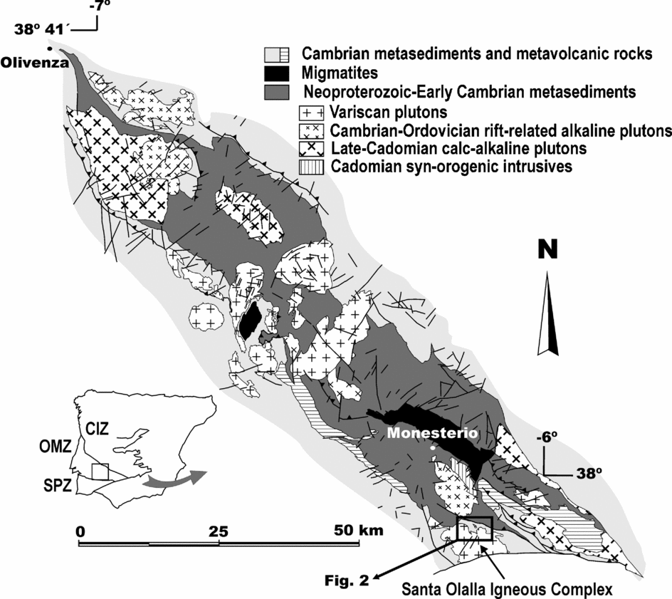
The Aguablanca stock belongs to the Santa Olalla Igneous Complex, which is located on the southern limb of the Olivenza–Monesterio antiform (Fig. 1), a major, WNW–ESE-trending Variscan structure, occupying a central position within the Ossa-Morena Zone. This zone forms one of the SW divisions of the Iberian Massif, which corresponds to the westernmost outcrops of the Variscan orogen in Europe. The Ossa-Morena Zone has also been interpreted as a poly-orogenic terrane accreted to the Central Iberian Zone during the Cadomian orogeny (620–530 Ma), the suture of which is exposed along the Badajoz–Córdoba shear zone (Quesada, Reference Quesada, D'Lemos, Strachan and Topley1990, Reference Quesada1991, Reference Quesada, Araujo and Pereira1997; Eguíluz et al. Reference Quesada and Dallmeyer2000). A subsequent rifting event culminating in formation of new oceanic crust (Rheic Ocean?) is recorded in the Ossa-Morena Zone during Cambro-Ordovician times (Liñán & Quesada, Reference Liñán, Quesada, Dallmeyer and Martínez-García1990; Sánchez-García, Bellido & Quesada, Reference Sánchez-García, Bellido and Quesada2003; Expósito et al. Reference Expósito, Simancas, González Lodeiro, Bea, Montero and Salman2003). This was followed by a passive margin stage until the onset of the Variscan orogeny in mid-Devonian times. At this point in time, Variscan tectonics started with oblique subduction of the Rheic Ocean beneath the southern margin of the Ossa-Morena Zone, where accretion and eventual obduction of oceanic fragments gave birth to the Pulo do Lobo accretionary prism and Beja–Acebuches Ophiolite (Munhá, Barriga & Kerrich, Reference Munhá, Barriga and Kerrich1986; J. B. Silva, unpub. Ph.D. thesis, Univ. Lisboa, 1989; Quesada, Reference Quesada1991; Quesada et al. Reference Quesada, Fonseca, Munha, Oliveira and Ribeiro1994) and coeval growth of a modest arc on the Ossa Morena plate (Santos et al. Reference Santos, Mata, Gonçalves and Munhá1987). Subduction of the oceanic crust finally led to oblique (sinistral) collision with the South Portuguese Zone, presumably an Avalonian part of already amalgamated Laurussia, which diachronously propagated southeastwards from the late Devonian to the late Visean (Ribeiro, Quesada & Dallmeyer, Reference Ribeiro, Quesada, Dallmeyer, Dallmeyer and Martínezdr García1990; Quesada, Reference Quesada1991). Subsequent orogenesis consisted of sinistral continental subduction of the outer margin of the South Portuguese Zone under the Ossa-Morena Zone until its waning in Early Permian times. During the whole orogenic process, the Ossa-Morena Zone acted as the upper plate subjected to a transpressional tectonic regime, consequently reactivating the pre-existing Cadomian suture under sinistral wrench conditions (Badajoz–Córdoba shear zone); this shear zone now constitutes the northern boundary of the Ossa-Morena Zone (Ribeiro, Quesada & Dallmeyer, Reference Ribeiro, Quesada, Dallmeyer, Dallmeyer and Martínezdr García1990; Quesada, Reference Quesada1991; Ábalos, Gil Ibarguchi & Eguiluz, Reference Ábalos, Gil Ibarguchi and Eguiluz1991; Quesada & Dallmeyer, Reference Quesada and Dallmeyer1994).
Plutonic rocks in the Olivenza–Monesterio antiform. The location of Figure 2 corresponding to the Aguablanca stock is indicated. Inset: Southern divisions of the Iberian Massif (CIZ – Central Iberian Zone; OMZ – Ossa-Morena Zone; SPZ – South Portuguese Zone).

The structural evolution of the Ossa-Morena Zone during the Variscan orogeny was mainly governed by transpressional tectonics throughout its time-span (from the Middle Devonian to the Early Permian). This transpressional regime resulted in the formation of a thick-skinned, strike-slip duplex structure, mainly after inversion of the pre-existing horst and graben tectonic compartmentalization acquired during the Cambrian–Ordovician rifting event (Sánchez-García, Bellido & Quesada, 2003). Internal deformation of each horse is variable and includes several folding and oblique thrust generations, as well as coeval extensional (transtensional) events. In the case of the Olivenza–Monesterio antiform, the basement was shortened by developing an antiformal stack, which tightened in several steps, whereas the Palaeozoic cover detached from it and initially formed a typically thin-skinned, SW-verging imbricate fan and large associated recumbent folds (Vauchez, Reference Vauchez1975; Quesada et al. Reference Quesada, Fonseca, Munha, Oliveira and Ribeiro1994; I. Expósito, unpub. Ph.D. thesis, Univ. de Granada, 2000). A second folding event, also SW-vergent but characterized by steep axial planes, affected the already deformed thin-skinned imbricate fan after an intervening extensional event, during which some syn-orogenic basins were formed (e.g. the Terena flysch basin). Finally, the overall NW–SE trend of the orogen was reworked by late sinistral strike-slip faults striking N50–70°, which generated the cartographic sigmoidal shapes that characterized the tectonic structure of the Ossa-Morena Zone.
Variscan plutonism in the Ossa-Morena Zone is characterized by intermediate to acid calc-alkaline compositions ranging from metaluminous tonalite and granodiorite to peraluminous granite and leucogranite, and by volumetrically minor gabbroic plutons. The main Variscan plutonic complex in the Olivenza–Monesterio antiform is a sub-circular group of plutons formed by Valencia del Ventoso, Bazana, Brovales (340±4 Ma, Pb–Pb Kober on zircons: Montero et al. Reference Montero, Salman, Bea, Azor, Exposito, González Lodeiro, Martínez Poyatos and Simancas2000; the method is described in Kober, Reference Kober1987), Valuengo (342±4 Ma, Pb–Pb Kober on zircons: Montero et al. Reference Montero, Salman, Bea, Azor, Exposito, González Lodeiro, Martínez Poyatos and Simancas2000) and Burguillos del Cerro (330±9 Ma, total rock Rb–Sr: Bachiller et al. Reference Bachiller, Galindo, Darbyshire and Casquet1997; 335 Ma, Ar–Ar on amphibole: Dallmeyer, García Casquero & Quesada, Reference Dallmeyer, García Casquero and Quesada1995; 338±1.5 Ma, U–Pb on allanite: Casquet et al. Reference Casquet, Galindo, Darbyshire, Noble and Tornos1998). Spatially separated from this group of plutons, 50 km to the SE, is the Santa Olalla Igneous Complex (340±3 Ma, U–Pb on zircons, Romeo et al. Reference Romeo, Capote, Tejero, Lunar and Quesada2006b) that contains the Aguablanca stock. A later extensional Permian event generated a set of NW–SE-trending diabasic dykes (250±5 Ma, total rock K–Ar: Galindo, Muńoz & Casquet, Reference Galindo, Muñoz and Casquet1991) that can be found in numerous localities across the Ossa-Morena Zone.
2.a. The Santa Olalla Igneous Complex
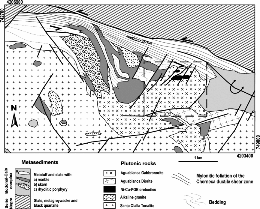
The Aguablanca stock (Fig. 2), a mafic pluton, crops out in the northern part of the Santa Olalla Igneous Complex (Romeo et al. Reference Romeo, Capote, Tejero, Lunar and Quesada2006a,b). The geochronology of the Santa Olalla Igneous Complex has been recently established (Romeo et al. Reference Romeo, Capote, Tejero, Lunar and Quesada2006b) by U–Pb ID-TIMS on zircons. The bulk of samples yield ages clustering around 340±3 Ma: the Santa Olalla tonalite (341.5±3Ma), the Sultana hornblende tonalite (341±3Ma), a mingling area of the Aguablanca gabbronorite with a felsic hybrid rock (341±1.5 Ma, interpreted as the age of the Aguablanca stock), the Garrote granite (339±3 Ma), the Teuler granite (338±2Ma), and dioritic dykes from the Aguablanca stock (338.6±0.8Ma). With this data, the Variscan age of the Ni–Cu–PGE ore is very well constrained since it was formed after the Aguablanca stock crystallization (341±1.5 Ma) and before the dioritic dykes intrusion (338.6±0.8 Ma) that appears, cutting both the mineralized breccia and the Aguablanca stock. The emplacement and tectonic evolution of the Santa Olalla Igneous Complex is mainly controlled by a sinistral ductile shear zone, the Cherneca shear zone (Romeo, Capote & Lunar, Reference Romeo, Capote, Lunar and Cayzer2007).
Geological map of the Aguablanca stock and the Cherneca ductile shear zone. The dashed square indicates the area covered by the gravity survey. Coordinates are UTM 29, metres.

The Aguablanca stock is composed of phlogopite-rich gabbronorite and norite, grading in the south to diorite. This intrusion has undergone significant endoskarn processes along the northern boundary induced by contact with the Cambrian Bodonal–Cala marbles (C. Casquet, unpub. Ph.D. thesis, Univ. Complutense de Madrid, 1980). This band of marbles is affected by an intense ductile deformation generating different types of mylonites. This intense deformation corresponds to the Cherneca ductile shear zone, a Variscan sinistral transpressional structure whose kinematics has been well established since the study of the microstructures and crystallographic preferred orientations performed by Romeo, Capote & Lunar (Reference Romeo, Capote, Lunar and Cayzer2007). The exoskarn produced by the Aguablanca intrusion is deformed by the Cherneca shear zone (Romeo, Capote & Lunar, Reference Romeo, Capote, Lunar and Cayzer2007).
The emplacement level of the Aguablanca stock was shallow (2–4 km, 0.5–1 kbar: C. Casquet, unpub. Ph.D. thesis, Univ. Complutense de Madrid, 1980), into a low-temperature environment (very low regional metamorphism).
2.b. The Aguablanca Ni–Cu–PGE ore
The Aguablanca Ni–Cu–PGE deposit (Lunar et al. Reference Lunar, Ortega, Sierra, Palomero, Moreno, Prichard and Papunen1997; Ortega et al. Reference Ortega, Moreno, Lunar, Prichard, Sierra, Bomati, Fisher and García Palomero1999; Tornos et al. Reference Tornos, Casquet, Galindo, Canales, Velasco and Stanley1999; Ortega et al. Reference Ortega, Prichard, Lunar, García Palomero, Moreno and Fisher2000; Casquet et al. Reference Casquet, Galindo, Tornos, Velasco and Canales2001; Tornos et al. Reference Tornos, Casquet, Galindo, Velasco and Canales2001; Ortega et al. Reference Ortega, Lunar, García-Palomero, Moreno, Estevez, Prichard and Fisher2004; Piña et al. Reference Piña, Lunar, Ortega, Gervilla, Alapieti and Martínez2006, Reference Pinto, Casas, Rivero and Torné2007) is hosted by the Aguablanca gabbronorite and is closely associated with a subvertical (dipping 70–80°N), funnel-like magmatic breccia (250–300 m wide N–S and up to 600 m long E–W) located in the northern part of this pluton. The breccia is comprised of barren or slightly mineralized ultramafic–mafic cumulate fragments enveloped by hornblende and phlogopite-rich gabbronorite containing disseminated and semi-massive Ni–Cu–Fe magmatic sulphides. The Aguablanca ore is mainly controlled by late-Variscan N40° sinistral strike-slip faults.
The breccia is dominated by a matrix of hornblende and phlogopite-rich gabbronorite containing Ni–Cu–Fe sulphides that host barren or slightly mineralized mafic–ultramafic rock fragments. Within the fragments, sulphides are restricted to weak disseminations (often associated with hydrothermal amphibole) and to chalcopyrite veinlets that cross-cut both fragments and host rocks (Piña et al. Reference Piña, Lunar, Ortega, Gervilla, Alapieti and Martínez2006). In the ore-bearing matrix, mineralization occurs mostly as disseminated and semi-massive sulphide ore. In the disseminated ore, sulphides occur as polymineralic aggregates interstitial to the silicate framework, representing less than 20 modal %. Leopard-textured sulphides (Evans-Lamswood et al. Reference Evans-Lamswood, Butt, Jackson, Lee, Muggridge, Wheeler and Wilton2000), reaching modal proportion as high as 85% but commonly between 20 and 70%, form the semi-massive ore. This texture comprises black spots consisting of idiomorphic silicates (mostly pyroxene, olivine and/or plagioclase) enclosed in a yellowish groundmass of magmatic sulphides.
The Ni–Cu–PGE ore has been described in detail by Ortega et al. (2000, 2004). According to those workers, the main ore minerals forming the magmatic sulphide assemblage are pyrrhotite, pentlandite and chalcopyrite. Accessory minerals include magnetite, ilmenite, rutile, native gold and various platinum group minerals. The latter are mainly Pt and Pd tellurides and bismutho-tellurides, namely michenerite, merenskyite, palladianbismuthian-melonite and moncheite, with minor sperrylite and Ir–Os–As–S–bearing-phases. This association is overprinted by hydrothermal pyrite related to the skarn processes. Recently Piña et al. (Reference Piña, Lunar, Ortega, Gervilla, Alapieti and Martínez2006) have performed systematic chemical and mineralogical analyses of a variety of igneous fragments with cumulate textures that the breccia has entrained, wrapped in the mineralized sulphide liquid, to reconstruct the sequence of the original cumulate magmatic chamber. The compositions of the various cumulate fragments can be linked by fractional crystallization processes. With the present knowledge of the ore, the following genetic hypothesis may be outlined (Piña et al. Reference Piña, Lunar, Ortega, Gervilla, Alapieti and Martínez2006). The segregation of an immiscible sulphide melt took place during the early stages of the evolution of the magma, coeval with the crystallization of peridotite. Because of its high density, this sulphide-rich melt settled to the base of the chamber, while above this, the silicate fluid generated the cumulate sequence by crystal fractionation processes. Finally, a new magma pulse intruded the chamber and mingled with the sulphide liquid, breaking into fragments the differentiated complex generated above. Magma overpressure at this position within the chamber, combined with availability of coeval extensional (transtensional) fractures, led to the explosive emplacement of the sulphide-cemented breccias along the fractures into shallower environments (Piña et al. Reference Piña, Lunar, Ortega, Gervilla, Alapieti and Martínez2006). The origin of magma overpressure was probably high water content, indicated by the presence of hydrated phases, as magmatic amphibole.
3. Magmatic structure of the Aguablanca stock
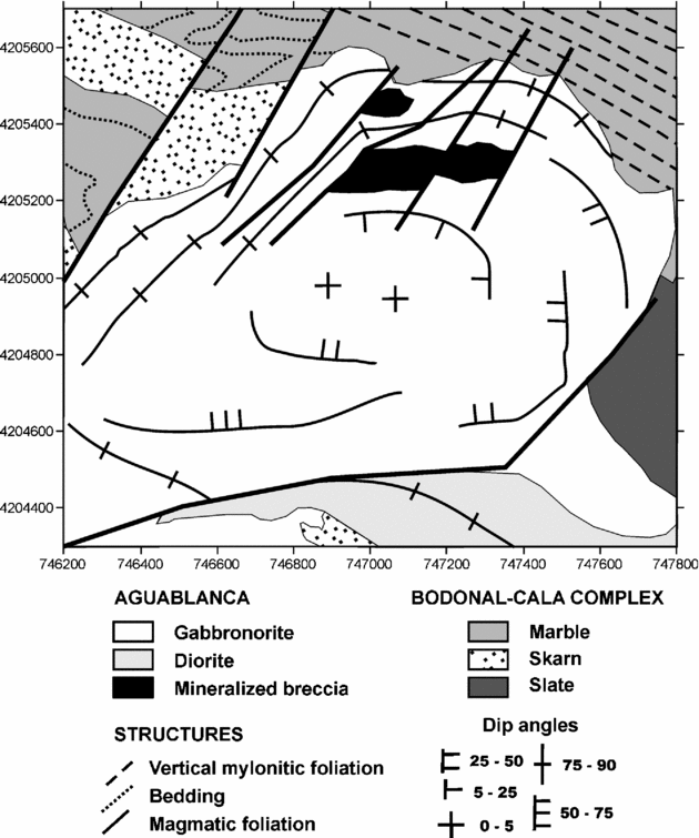
Magmatic foliations in the Aguablanca stock are mainly defined by the preferred orientation of plagioclase. The trajectories of these magmatic foliations are concentric in respect to the intrusion boundaries (Fig. 3). Magmatic foliations are mainly vertical and parallel to the pluton boundaries in the surroundings of the intrusive contact with the Bodonal–Cala marbles towards the N, NW and NE. Subvertical mineral lineations defined by the preferred orientation of pyroxene and plagioclase have only been observed in this northern area near the contact with the mylonites of the Cherneca shear zone, being more intense in the surroundings of the mineralized breccia pipes. Subhorizontal magmatic foliations dominate in the central area of the stock. The transition between the vertical magmatic foliations of the northern area to the horizontal magmatic foliations in the centre of the stock is characterized by low to intermediate dips to the south. The SW margin of the intrusion features diorites with magmatic foliations striking N150° with high dip angles towards the NE.
Structural scheme of the study area. Coordinates are UTM 29, metres.

There is a gradient in the intensity of the magmatic fabrics, being more intense towards the margins and especially toward the NE contact with the shear zone. Magmatic lineations are only developed in the NE area, which indicates a gradual change in the shape of the fabric ellipsoid from intermediate (prolate–oblate) in the NE area to oblate towards the south, where only foliations are observed.
Although the N40° sinistral strike-slip faults highly modified the intrusive contacts of the stock, it can be appreciated that these intrusive contacts are mainly discordant in respect to the bedding of the marbles out of the Cherneca shear zone, but they are subparallel to the mylonitic foliation in the contact with the mylonitic marbles towards the NE.
4. Gravity study
4.a. Gravity survey
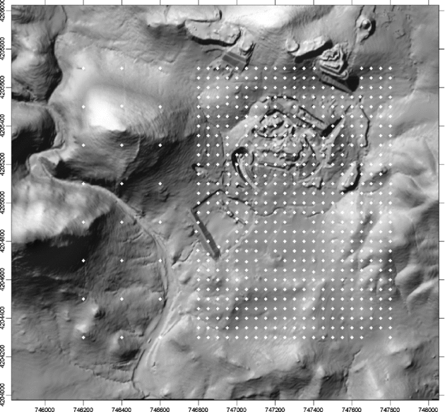
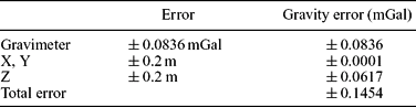
The gravity survey covers an area of 2.24 km2, where 605 gravity stations were measured. The study area comprises the Aguablanca stock. Initially, a 200 m square grid was designed. The results obtained from this preliminary gravity survey indicated that a denser gravity survey was needed to detect the presence of the mapped orebodies. Consequently, the station density was increased to a 50 m square grid. The location of the gravity stations is indicated on the topographic grid used for terrain correction (Fig. 4). Measurements were performed using a LaCoste & Romberg G-metre 953 from the Departamento de Geodinámica of the Universidad Complutense de Madrid with a nominal precision of ±0.01 mGal. A station located in Monesterio, Badajoz (absolute gravity: 979862.77 mGal), was used as gravity base station (linked to the Spanish Geographic Institute base station at Fuente de Cantos, Badajoz). Elevations and coordinates were determined by a differential GPS unit with a nominal precision of ±0.01 m, enabling measurements of X, Y and Z coordinates with an error of ±0.2 m. A comparison of 10% duplicate gravity measurements revealed a root mean square instrumental error of ±0.08 mGal in the determination of the observed gravity. This procedure enables one to estimate error margins of ±0.14 mGal for the gravity survey (see Table 1 for details).
Location of the gravity stations on the digital elevation model used for the terrain correction. Coordinates are UTM 29, metres.

Error calculus of the gravity survey

The gravity measurements were corrected for Earth-tide effects, and free-air and Bouguer reductions were applied. The density value used in the Bouguer reduction was 2750 kg m−3. Terrain correction up to 22 km was also performed, using the Terrain Correction function of the software Oasis montaj™ by Geosoft. Terrain correction from 0 to 200 m was performed using a detailed digital elevation model (1 m square grid), and corrections from 200 m to 22 km were carried out with a regional digital elevation model with a 250 m square grid. Kriging was used to interpolate the Bouguer anomaly values in a square grid of 12.5 m.
4.b. Bouguer anomaly map and residual anomaly map
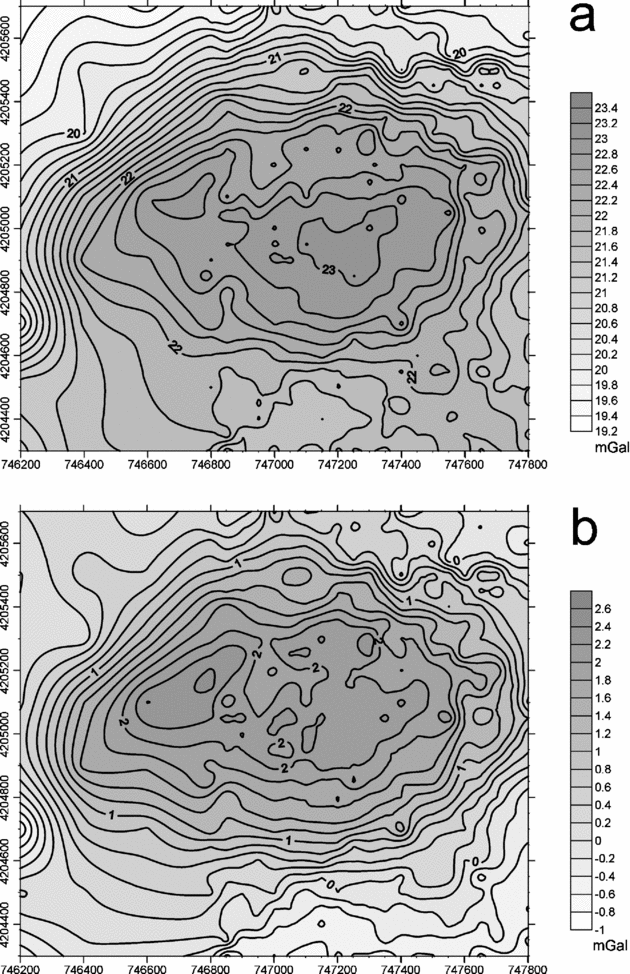
The Bouguer anomaly is characterized by positive values ranging from 19 to 23.4 mGal. The anomaly features a maximum with an E–W orientation (Fig. 5a). The maximum superposes on a N-dipping ENE–WSW-striking regional gradient. This regional gradient characterizes this part of the Ossa-Morena Zone, as can be seen from the gravity surveys performed by N. Sánchez-Jiménez (unpub. Ph.D. thesis, Univ. Lisboa, 2003) and Romeo et al. (Reference Romeo, Capote, Tejero, Lunar and Quesada2006a). From a geological point of view, the maximum is centred in the Aguablanca stock, suggesting that the denser rocks of the pluton are the source for gravity anomaly.
(a) Bouguer anomaly map and (b) residual anomaly map. The interval between anomaly lines is 0.2 mGal. Coordinates are UTM 29, metres.

A regional-residual separation was performed. The Bouguer map of N. Sánchez-Jiménez (unpub. Ph.D. thesis, Univ. Lisboa, 2003) was used as the regional anomaly map. It covers all the Ossa-Morena Zone and a part of the South Portuguese Zone with 0.07 stations per km2. This low data density generates a map dominated by large wavelengths which are interpreted to be caused by deep-seated sources, considering that this gravity survey was design to model the cortical density structure (N. Sánchez-Jiménez, unpub. Ph.D. thesis, Univ. Lisboa, 2003). These regional data were subtracted from our Bouguer map in order to obtain a residual anomaly map.
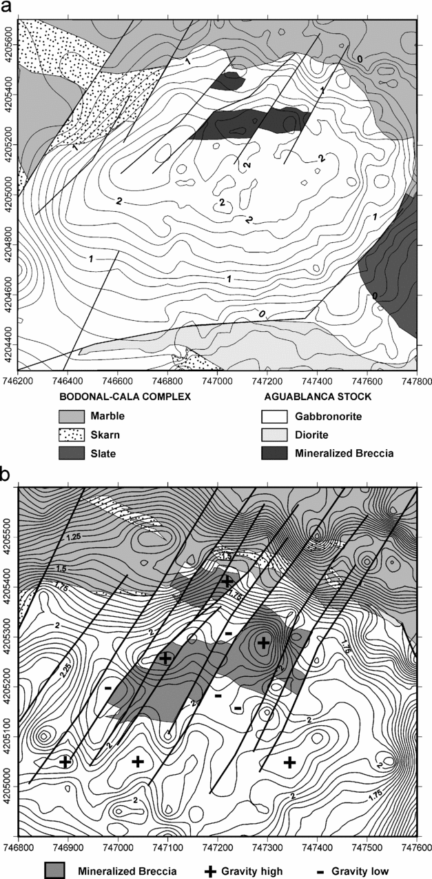
The obtained residual anomaly map (Fig. 5b) is characterized by a positive anomaly with a maximum of 3.5 mGal elongated in an E–W direction. Different minor anomalies with low amplitude and wavelength occur in the upper part of the main gravity high. Residual anomaly significance is highlighted when geology is superposed on the residual anomaly map (Fig. 6a). The relationship between the Aguablanca gabbronorite and the residual anomaly is clear. The main gravity high can be attributed to the density contrast between the Aguablanca gabbronorite and the surrounding rocks. Anomaly contours delineate the gabbronorite limits except for the SW area where it appears to exceed the maximum. The decrease of the anomaly value in this area points out a possible thickness reduction of this high-density lithology. The low wavelength and low amplitude anomalies are mainly controlled by lineaments striking NE–SW that are coincident with the sinistral strike-slip faults shown in the geological map.
(a) Residual anomaly map of the study zone and geology are superposed for an easier comparison. The interval between anomaly lines is 0.2 mGal. Coordinates are UTM 29, metres. (b) Detailed residual anomaly map of the northern area and the geology of the mineralized breccia pipes are superposed for comparison. The interval between anomaly lines is 0.05 mGal. Coordinates are UTM 29, metres.

There is a good correlation between the two known orebodies and low amplitude and wavelength maxima (Fig. 6b), which is logical considering the density contrast between the gabbronorites and the semi-massive sulphides. Although other similar anomalies appear on the main gravity high, the exploration drilling campaign in these areas has not revealed new orebodies.
4.c. Density determinations and modelling
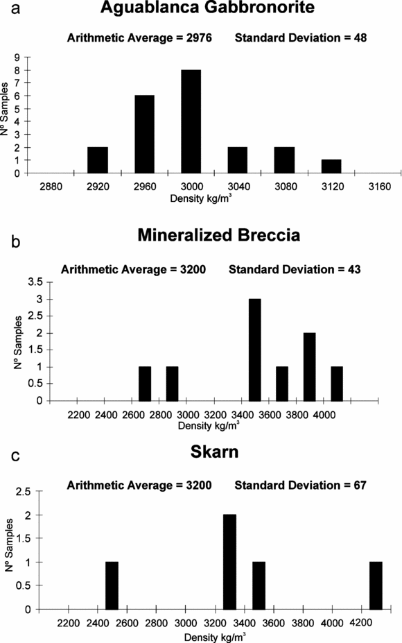
Density determinations of the main lithologies in the study area were obtained from surface samples and drill-cores, in order to constrain the modelling process. These density data of the main anomaly-generator lithologies are represented as histograms in Figure 7. The average density of the main geological units used during the modelling process is indicated for each histogram. High density values are dominant; for instance, the gabbronorites show values from 3000 to 2800 kg m−3, although the highest density measurements were obtained for sulphides and skarn.
Histograms of density determinations of the main anomaly-generator lithologies: (a) Aguablanca gabbronorite, (b) mineralized breccia, (c) skarn.

Three-dimensional density models obtained from gravity surveys have been widely applied to solve different geological problems (Grabowska, Bojdys & Dolnicki, Reference Grabowska, Bojdys and Dolnicki1998; Ebbing et al. Reference Ebbing, Janle, Koulouris and Milkereit2001; Ayala, Torne & Pous, Reference Ayala, Torne and Pous2003; Yegorova et al. Reference Yegorova, Stephenson, Kostyuchenko, Baranova, Starostenko and Popolitov2004; Ebbing, Reference Ebbing2004; Pinto et al. Reference Pinto, Casas, Rivero and Torné2005). The 3D gravity modelling eludes the intrinsic problems of 2½D or 2¾D models related to the effect of the out-of-model density distribution. Three-dimensional modelling in this contribution was accomplished by using the software GMSYS-3D™ (3D Gravity and Magnetic Modelling module for Oasis montaj™ 1.2). The density model is defined by surfaces that separate volumes with different densities. Anomaly calculus was performed in the Fourier domain using the algorithms of Parker (Reference Parker1972). Structural inversion methods were applied during modelling, based on the procedures defined by Blakely (Reference Blakely1995). Model surfaces and anomaly data have to be represented by grid files with the same number of rows and columns, the same origin and periodicity along any direction.
The geometry of the model was initially constrained by: (1) the structural data previously presented, (2) the drilling exploration campaign performed in the area of the Aguablanca mineralization (some drills have reached 1000 m depth), and (3) the surface geology represented by the geological map.
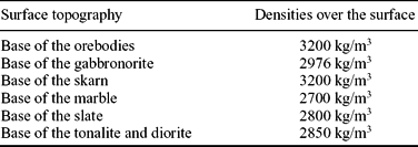
Initially, the modelling process started with a simple three-body model where the main gravity high was justified by the density contrast of the gabbronorites in respect to the northern marbles and the southern tonalites and diorites. Later the model was completed with three new minor bodies giving a better correlation of the model anomaly with the observed anomaly; these new included bodies were: the two mineralized magmatic breccia pipes of the Aguablanca Ni–Cu–PGE ore with semi-massive sulphides, the main skarn body located in the NW intrusive contact of the Aguablanca stock, and the slate that limits the stock towards the east. Table 2 indicates the surfaces and densities that define the final 3D model.
Surfaces and densities defining the 3D model

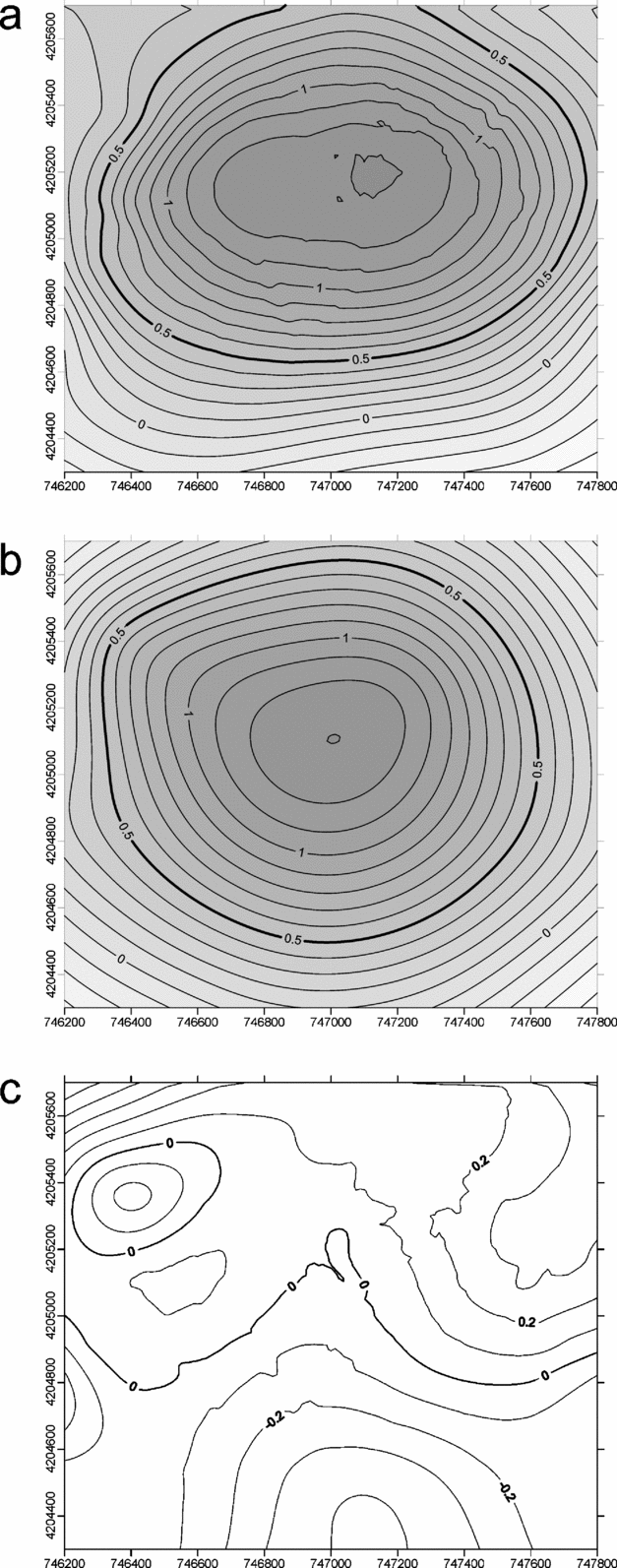
The modelling process requires an observed anomaly referred to a constant altitude. This constant altitude must be above the topography. In our case, the observed residual gravity measured in the surface level was prolonged to a horizontal surface with an elevation of 650 m (Fig. 8a).
(a) Observed residual anomaly at 650 m; these data were used for modelling. (b) Model anomaly at 650 m. (c) Error of the model. The interval between anomaly lines is 0.1 mGal. Coordinates are UTM 29, metres.

Figure 8b shows the gravity anomaly calculated for the model and Figure 8c indicates the model error, the standard deviation of which is 0.18417 mGal. A finer adjustment of the model with the observed gravity is not justified considering that the model error (±0.18417 mGal) and the gravity survey error (±0.145478 mGal) are similar.
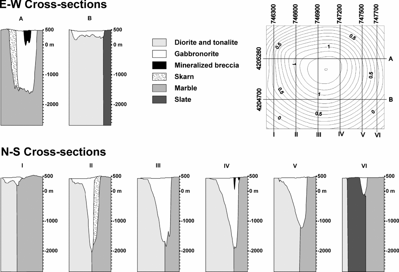
The model has been cut along six N–S and two E–W cross-sections for a complete visualization of the 3D geometry (Fig. 9). The 3D modelling has revealed that the Aguablanca pluton has an inverted drop geometry. The N–S cross-sections of the model illustrate different geometries of the northern and southern limits of the stock. The stock shows the deeper values reaching −2000 m in the northern contact of the Aguablanca gabbronorite with the Bodonal–Cala marbles. Consequently, the root of the intrusion is located in the northern border in direct contact with the mylonitic marbles of the Cherneca ductile shear zone. The Aguablanca gabbronorite thins towards the south, covering the tonalites and diorites of Santa Olalla with a layer less than 200 m in this area (cross-section II in Fig. 9).
Geometry of the 3D model. The model is represented by six N–S cross-sections and two E–W cross-sections; their locations are indicated on the model anomaly map.

One of the aims of the modelling was to investigate the existence of small dense bodies that could represent semi-massive sulphides of economic interest. Only the mapped mineralized breccia was needed to fit the gravity anomaly. The obtained morphology for the mineralized magmatic breccia pipes is characterized by a subvertical geometry within the gabbronorite root located close to the northern margin.
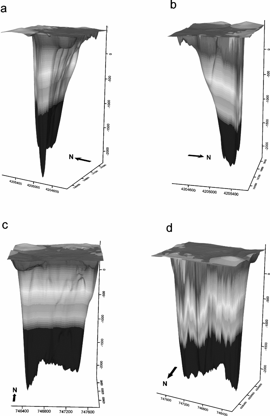
Although the gravity high contours are subparallel to the stock boundaries, the centre of the gravity high does not correspond to the centre of the stock. The highest gravity values are closer to the northern boundary of the stock than to the south. This obligates us to consider during the modelling process that the gabbronorites are thicker in the northern part of the stock than in the southern part, where we have determined that they are only represented by a very thin layer. This asymmetry of the Aguablanca stock can be appreciated in the 3D views of the modelled gabbronorites from different viewpoints in Figure 10. In these views, the lower surface represents the base of the Aguablanca gabbronorites and the upper surface corresponds to the topography.
Four 3D views of the modelled Aguablanca stock. The lower surface represents the base of the gabbronorite and the upper surface is the topographic level. Coordinates are UTM 29, metres.

5. Discussion
The detailed gravity survey performed in the Aguablanca area has revealed the presence of an anomaly of 3.5 mGal amplitude. The geometry and the location of this anomaly indicate that it can be related to the high density rocks of the Aguablanca stock, whose mafic composition (gabbronorite) contrasts with the surrounding rocks (tonalites, diorites and marbles). This anomaly is mainly generated by the gabbronorites, but there is also an important contribution from the mineralized breccia pipes that are associated with secondary maxima in the residual anomaly map (Fig. 6b), as well as a significant contribution from the skarn located in the contact between the mafic intrusion and the Bodonal–Cala marbles to the main anomaly. The contribution to the gravity field of these high-density bodies, the mineralized magmatic breccia pipes and the skarn, has been modelled as well.
Magma feeder zones are usually related to the deepest parts of plutons (Vigneresse, Reference Vigneresse1990; Yenes, Alvarez & Gutiérrez-Alonso, Reference Yenes, Alvarez and Gutiérrez-Alonso1999; Galadí-Enríquez et al. Reference Galadí-Enríquez, Galindo-Zaldívar, Simancas and Expósito2003, among others). The root for the Aguablanca intrusion, located in the northern margin of the stock with a subvertical wedge geometry adjacent to the Cherneca ductile shear zone, indicates that probably this structure was the magma feeder zone. The relationship between shear zones and magma emplacement has been widely discussed by Hutton & Reavy (Reference Hutton and Reavy1992) and Reavy & Hutton (Reference Reavy and Hutton1992), among others. The Cherneca shear zone has recently been proposed to be the feeder zone for the magmas of the Santa Olalla Igneous Complex, including the Santa Olalla stock and the Aguablanca stock (Romeo et al. Reference Romeo, Capote, Tejero, Lunar and Quesada2006a). The 3D model of the present study confirms that the magmas of the Aguablanca stock probably reached the present level ascending along the Cherneca shear zone. The Aguablanca stock is slightly discordant in the NE contact with respect to the shear zone (cutting the mylonitic foliation), and the exoskarn produced by the Aguablanca intrusion appears clearly deformed by the mylonitic deformation along the Cherneca shear zone (Romeo, Capote & Lunar, Reference Romeo, Capote, Lunar and Cayzer2007). Thus, the cross-cutting relationship between the Aguablanca stock and the Cherneca shear zone clearly indicates that the intrusion took place when the shear zone was already formed, and its deformation continued after that.
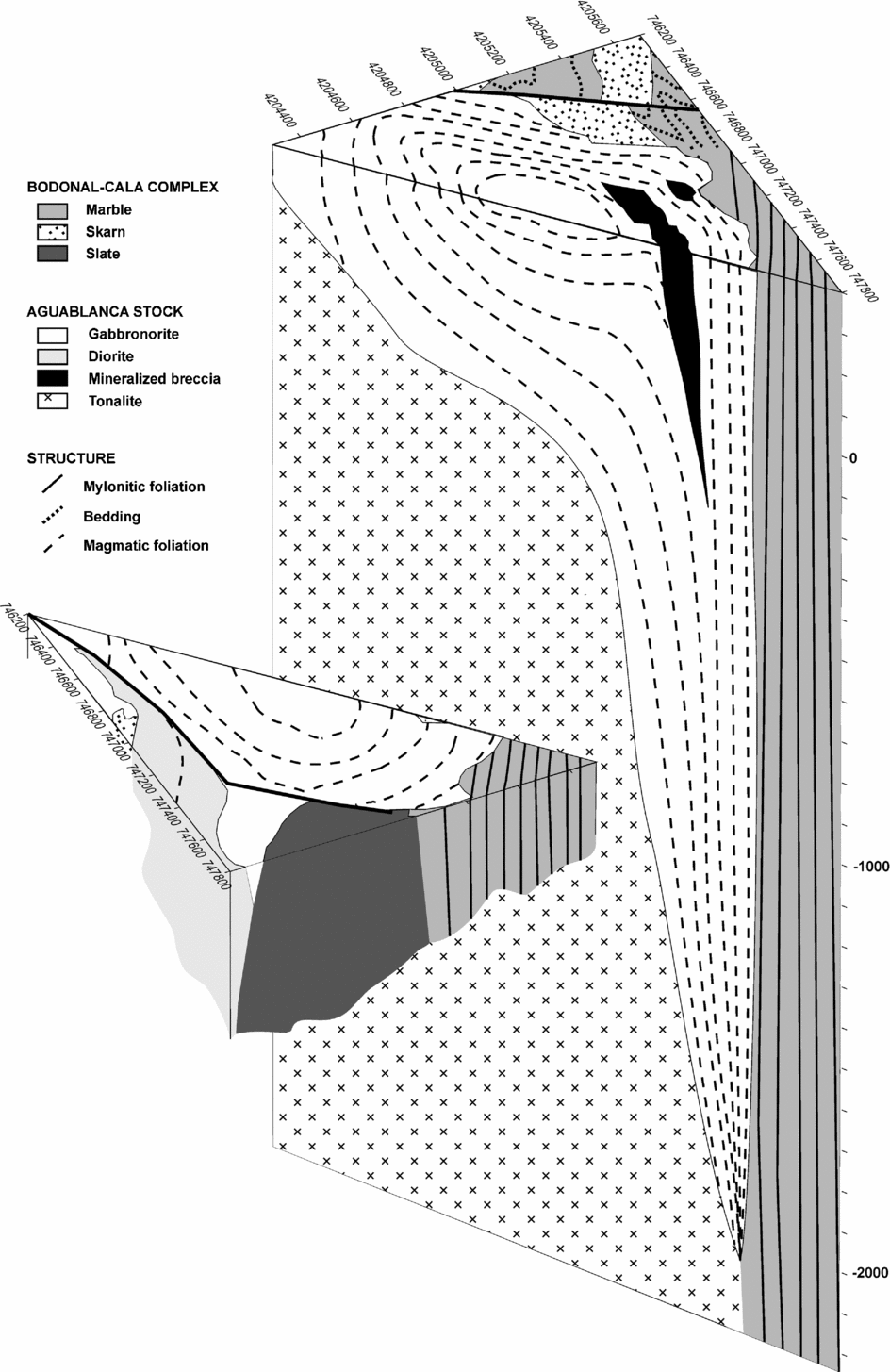
A 3D reconstruction of the Aguablanca stock with an interpretation at depth of the magmatic foliations is shown in Figure 11. In this figure, it can be appreciated that the Aguablanca stock has an inverted drop geometry ascending along the Cherneca ductile shear zone. This geometry obtained from the 3D gravity modelling is coherent with the observed magmatic fabrics on the surface, characterized by vertical magmatic foliation parallel to the margins and a horizontal foliation in the centre.
3D reconstruction of the Aguablanca stock based on gravity modelling and the surface structure.

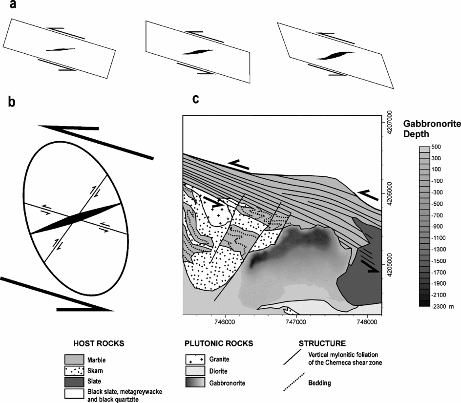
The 3D gravity model shows that the root of the gabbronorite has a wedge-shaped vertical geometry at the northern margin, but the long axis of this root is not parallel to the Cherneca ductile shear zone. The root of the Aguablanca stock has a N65°E strike while the Cherneca ductile shear zone strikes N115°E. The angle between both structures can be clearly seen in Figure 12c. The orientation of the feeder zone of Aguablanca is equivalent to the orientation expected for tension cracks developed in a sinistral ductile strike-slip shear zone with the strike corresponding to the Cherneca shear zone (Fig. 12a). The sinistral kinematics of the Cherneca ductile shear zone has been widely supported by the detailed study performed by Romeo, Capote & Lunar (Reference Romeo, Capote, Lunar and Cayzer2007), where mesoscopic kinematic indicators are coherent with microstructures and the crystallographic preferred orientations of calcite. Consequently, the obtained geometry of the Aguablanca stock indicates that it could have been emplaced along a hundred-metre-scale open tensional crack developed under the sinistral strike-slip ductile strain regime associated with the Cherneca shear zone (Fig. 12b).
Emplacement model of the Aguablanca stock along an open tensional crack developed during the sinistral displacement of the Cherneca ductile shear zone. (a) Formation of a tensional crack in a sinistral shear zone. (b) Strain ellipse deduced for the Cherneca shear zone indicating the expected orientation of tensional cracks. (c) Geological map of the Aguablanca stock and the Cherneca shear zone indicating the orientation of the root of the Aguablanca stock (darker area) parallel to the expected orientation of tensional cracks in the Cherneca shear zone.

The NE end of this tensional crack is located in the Cherneca mylonites and the crack extends far from the intense deformation shear zone towards the SW, where a less penetrative deformation is found. This zone is damaged by the strain regime and the sinistral displacement of the shear zone, favouring the propagation of tension cracks nucleated in the shear zone. Magma overpressure probably favoured the opening of this initially tectonically controlled structure. When the magma ascending along this open tensional crack reached the current erosion level it expanded towards the south, taking on its inverted drop geometry. The host rocks of the south belong to the Santa Olalla stock that was probably emplaced simultaneously (it has an equivalent U–Pb age: Romeo et al. Reference Romeo, Capote, Tejero, Lunar and Quesada2006a), probably being melted when the Aguablanca lateral expansion took place. This is in agreement with the lack of subsolidus flattening of the Santa Olalla rocks in the area surrounding Aguablanca. The filling of the pluton probably took place through multiple magmatic pulses, considering that different gabbronorite compositions have been found in the stock. The emplacement of the Ni–Cu–PGE mineralized breccia pipes along the same open tensional crack took place during the last filling stages of the stock. The stock was probably filled during different magmatic pulses mainly controlled by the gradual opening of this tensional crack.
The importance of tensional cracks as channels for magmatic ascent in wrench conditions was suggested by Glazner, Bartley & Carl (Reference Glazner, Bartley and Carl1999). In their study of the oblique subduction in southern California, they indicate how the upper plate suffers a sinistral strike-slip tectonic regime favouring the generation of en échelon tensional cracks directly filled by magma with the same oblique orientation obtained in our study. These tectonic conditions are very similar to the Variscan oblique collision in the SW Iberian Massif, where the Ossa-Morena Zone was the upper plate undergoing a sinistral strike-slip tectonic regime (Vauchez, Reference Vauchez1975; Quesada et al. Reference Quesada, Fonseca, Munha, Oliveira and Ribeiro1994).
The importance of the Cherneca shear zone for the emplacement of the Ni–Cu–PGE mineralized magmatic breccia pipes of Aguablanca deduced from this contribution indicates that prospecting the trace of the Cherneca shear zone and other Variscan shear zones associated to Variscan mafic plutonism are preferred objectives for exploration campaigns looking for new Ni–Cu–PGE ores in the Ossa-Morena zone.
6. Conclusions
The 3D modelling of a detailed gravity survey performed on the stock and the mineralized breccia pipes of Aguablanca has revealed an inverted drop geometry with a wedge-shaped vertical root located at the northern boundary of the stock. The root has been interpreted as a feeder zone, formed during the opening of a tensional crack associated with the simultaneous sinistral displacement along the adjacent Cherneca ductile shear zone. The Aguablanca gabbronorites and the Ni–Cu–PGE mineralized magmatic breccia pipes were emplaced through multiple magma pulses controlled by the opening of this tensional crack. An expansion of the stock to the south took place when magma reached the present-day surface level. This proposed emplacement mechanism is supported by both gravity 3D modelling and structural analysis of magmatic foliations. The present results indicate that the preferred targets for exploring new Ni–Cu–PGE ores in the area are Variscan mafic intrusions associated with Variscan shear zones.
Acknowledgements
We thank Rio Narcea Gold Mines for their support during the gravity survey. N. Sánchez-Jiménez is acknowledged for kindly lending the gravity data used as a regional value in the present contribution. We would like to thank the support given by D. Gómez-Ortiz during the gravity data processing. This research has been supported by Spanish grant PB98-0815.