

In November 1935, a mysterious illness struck the Chinese population of Keshan in the Japanese client state of Manchukuo (Shenbao 1935). The county seat—a middling and somewhat isolated town of 20,000 founded in 1915—lay at the end of a recently completed railroad line in what is now Heilongjiang, the northeast-most province of the People's Republic of China (Lattimore Reference Lattimore1934, 286, 288) (see figure 1). The following summer, representatives from the Department of Hygiene, the Manchukuo Army, and Mantetsu (or the South Manchuria Railway) descended upon Keshan. Traveling along dirt roads lined with sorghum-thatched, earthen farmhouses, Japanese investigators learned of victims suffering from fever, headaches, dizziness, cold limbs, chest pains, and nausea (see figure 2). From the onset of these symptoms, most people—after vomiting up yellow liquid—died within two days. Half of them were women between the ages of sixteen and thirty-five. Of the 130 known cases in Keshan and the surrounding six counties that year, 128 people had perished. Japanese doctors named the sickness Keshan Disease (Ch. Keshan bing, Ja. Kokuzan byō) (Abe Reference Toshio1937, 345–47).
Map of the former Mongol territories of Manchukuo. Data from Takemura (Reference Shigeaki1939). Figure by author.

Photograph of Village No. 36 in Keshan County. Reproduced from Manshū kokuritsu Kokuzan nōji shikenjō (1937). Courtesy of Harvard-Yenching Library.

In the 1970s, medical experts and geological chemists in the People's Republic of China identified selenium deficiency as the cause of this catastrophe (Keshan Disease Research Group 1979; Yu et al. Reference Wei-Han, Xian-Zhong, Shao-Juan, Zhe-Hong and Gao-Yang1985). As scientists like Yu Weihan have argued, Keshan Disease, like the degenerative bone disorder Kashin-Beck Disease (Ch. dagujiebing, Ja. Kashin-Bekku byō), erupts in areas that lack selenium and are undergoing intensive agricultural change.Footnote 1 This trace element helps develop enzymes that act as antioxidants, which prevent cell damage in human bodies caused by free radicals (Combs and Gray Reference Combs and Gray1998). According to the current literature, food grown in soil low in selenium made Keshan's villagers—especially younger women and children—susceptible to a fatal strain of the coxsackie virus (Beck, Levander, and Handy Reference Beck, Levander and Handy2003, 1463–67). While present research still cannot account for all of the definitive causes of the condition, a daily intake of around 55 micrograms of selenium seems to prevent Keshan Disease in adults. The denizens of Keshan likely absorbed one-fifth of that amount from locally sourced food (Fordyce Reference Fordyce and Selinus2005, 398). If the absence of this trace element emphasizes the importance of the geological milieu in enabling the possibility of human settlement, it offers a key inroad into illuminating the very nature of imperialism in Keshan.Footnote 2
Considering Keshan Disease as a selenium deficiency disorder makes the consequences of intensive agriculture visible among those who lived off the land. As Linda Nash (Reference Nash2006, 5–8) has noted, the body serves as a compelling site to explore local environments, and one that unsettles the modern dichotomy separating humans from nature: when considering the body as porous, we cannot know definitively where nature ends and the human begins. Accordingly, Keshan demonstrates the convergence of slow environmental changes (of both natural and human causes) with sudden medical breakthroughs under the conditions of imperialism. New theories on climate and hygiene from imperial Japan revealed the gradual accumulation of ecological decisions dating from the late Qing dynasty—decisions that transformed what had been a nomadic borderland into an agrarian heartland and reoriented regional economies towards global demands. These ecological decisions culminated with the Japanese creation of a colonial periphery; it was through an extractive and deliberate expansion of a soy frontier that the geological profile of the land was irrevocably changed. Despite the extraordinary agricultural output that resulted from this process, the repercussions of settler colonialism and environmental planning on the permeable bodies of imperial subjects reinforced civilizational hierarchies between Japanese occupiers and Chinese migrants.
In recent scholarship, narratives of environmental degradation in East Asia have tended to take place within the boundaries of the nation-state. This concept of “national ecologies” maintains the neat separation between the metropole and the extractive economies it created through imperial expansion, which were so necessary for modernization.Footnote 3 However, examining how the externalities of rapid development were exported to the periphery means confronting the environmental effects of industrial capitalism that cropped up well beyond the horizons of the nation-state. In the case of Keshan Disease, the center of the 1935 outbreak was in the Mongol territories of Manchukuo, a resource periphery to both China and Japan. Situating these lands at the center of the narrative reveals the ecological—and human—costs of imperialism.Footnote 4
Research on Manchukuo has proliferated in the last two decades, yet it has rarely touched upon the Mongol territories of the client state.Footnote 5 The northwestern lands historically controlled by Mongol princes, known as the banners, nonetheless accounted for 40 percent of Manchukuo's surface area (Narangoa Reference Narangoa2001, 102). From the late nineteenth century onward, Chinese colonization accelerated in the region. New trading posts and agricultural estates further cut into hunting grounds, grazing pastures, and swidden fields. Both the Qing and the successive Republican administration set up counties, like Keshan, to manage migrant settlers within the boundaries of the Mongol territories. As a result, Tungusic, Mongol, and Chinese communities increasingly overlapped in this region. Divergent visions held by Mongol banners and Chinese counties competing for the same space led to ethnic conflicts along the nomadic and sedentary divide until the Japanese invasion of Manchuria in 1931 (Borjigin Reference Burensain2007, 112–36; Bulag Reference Bulag, Schorkowitz and Ning2016; Lattimore Reference Lattimore1934, 109–34). As a result, the Japanese planners who set up the client state of Manchukuo in the 1930s sought to separate out Tungusic, Mongol, and Chinese populations and assign specific modes of production to their corresponding spaces: scientific ranching on its steppe and industrial farming on its plains. Their reductive programs refigured the land in such a way as to leave indelible imprints on the people who lived there. Recognizing the mottled nature of the borderlands, then, provides insight into the ethnic displacement and environmental violence that took place because of imperialism.
Much like surveying the geological strata of the earth, this article examines the layers of imperialism experienced by Keshan from the 1890s to the 1940s. Limiting the scope to just the archives of the Qing (1636–1911), Republican (1912–49), or Japanese (1931–45) periods would otherwise obscure this narrative; nature does not necessarily conform to such discrete and artificial units of analysis. To trace the emergence of Keshan Disease, then, this essay begins with the premise that selenium deficiency was its major, underlying cause. Much of the selenium cycling through human bodies and ecologies comes from volcanic activity churning up molten material from the planet's mantle to its surface. Selenium erodes into the soil and seeps into the water before making its way into plants consumed by humans and animals. The interplay between the earth and its climate system unevenly disperses minerals across the planet's crust, with selenium-rich and selenium-poor areas on all six of the continents where humans farm (Fordyce Reference Fordyce and Selinus2005, 378–81).
As for China, environmental scientists recently posited that the East Asian monsoon has shaped the distribution of a selenium-deficient band of soil from the country's northeast to the southwest, in which Keshan is located (Sun Guo-Xin et al. Reference Guo-Xin, Meharg, Li, Chen, Yang, Chen and Zhu2016). If so, then this pattern of selenium deficiency may have begun around fifteen to twenty million years ago with the strengthening of ocean air currents from the uplift of the Tibetan plateau (Liu and Yin Reference Liu and Yin2002). Keshan Disease has appeared throughout this belt, but usually erupts in remote areas, like Keshan County, where a high proportion of residents depend on their immediate surroundings for their food supply (Fordyce Reference Fordyce and Selinus2005, 397). Rather than explain selenium deficiency through a geologically static and deterministic model, the research here suggests that the dynamism of the earth and its climate unfolds along grander timescales. Thus, this longue durée perspective exposes how Keshan may have come to lack selenium.
Keshan stood on former Mongol territory known as Yeke Mingġan Banner (Ch. Yikeming'an).Footnote 6 During the late nineteenth century, changes in land use under settler colonialism sponsored by the Qing and Republican state very likely threatened the limited selenium supply in the soil. This borderland witnessed the dramatic shift from pastoral nomadism to intensive agriculture within a short span of fifty years. Largely driven by the integration of Manchuria's soybean industry into the global market after the Russo-Japanese War, this transition created prime conditions for selenium deficiency among its inhabitants. Converting what Chinese officials and migrants viewed as “wasteland” into farmland through settler colonialism seems to have accelerated the depletion of already scarce reserves of the mineral. Keshan Disease, however, only became codified via medical research conducted by Japanese occupiers throughout Manchukuo's countryside. Japanese specialists on endemic disease were convinced that the continental climate had shaped what they saw as unhygienic customs among Chinese migrants that led to Keshan Disease. In the absence of stark racial divides, then, both cultural understandings and material conditions of the environment acted as defining markers of colonial difference in the Japanese empire.
A Vernacular History of “Vomiting Yellow Water Disease”
For at least four decades before the 1935 outbreak, residents of Keshan and its surrounding counties had suffered from symptoms that seem to match those of what doctors now call selenium deficiency disorders. People at the time, however, named these maladies based on their bodily reactions, in vernacular terms such as “the swift and speedy sickness” (Ch. kuaidang bing), “vomiting yellow water disease” (Ch. tu huangshui bing), and a case of the “heart-attacking flutters” (Ch. gongxin fan) (Wang Reference Kejian2003, 2). The Heilongjiang Draft Gazetteer documented their consequences on homesteads along the Lalinqing River in the early 1890s:
After ten or so years [of reclamation] all of the women, infants, and the middle-aged died, with only the elderly surviving without serious injury. The youth who were fortunate to survive all grew thick, clumsy, and short with broad waists, big joints, and twisted legs.… When they had the chance, many deserted, moving entire households and affixing their land licenses to the door while leaving all of their belongings inside. (Wan and Zhang [1932] Reference Fulin and Boyin1992, 1:442)
To explain these alarming episodes, residents portrayed their land and water as contaminated, and they responded by fleeing the area. In 1903, for example, the lieutenant general in the Tungken garrison wrote to the military governor of Heilongjiang concerning the abrupt departure of his soldiers. “Not one person dares to … [use] this land again,” he lamented, after the bannermen and their farmhands “abandoned the wasteland because … the earth and water were sick and poisoned.” The military governor decided to prevent further settlement in the area (DBDX 2007, 127:128–29, 239–40). As a result, this episode was repeated in Keshan years later among a new, unsuspecting population. Contemporary records documented that in 1919 women in the Yueliangbao area had “vomited yellow water from their mouths and died,” so the inhabitants had fled one after another, leaving their farms to seed (Sun Jianping Reference Quanfang and Jingwen1992, 710). The death of some eight hundred people prompted one-third of the four hundred households to pack up their belongings and move (8–9). A year later, locals blamed the toxic well water in a separate incident that killed over one thousand inhabitants in the Dongdagang area. Nearly three hundred families decamped, leaving three villages completely deserted without a single person remaining (9). An economic profile of Keshan from 1933 recognized that “hands and feet become crooked or joints develop tumors. It is not uncommon to see freakish limbs transported on the road. Likewise … women … who [complain of] throat pain and end up dying violently are exceeding in number” (Manshū kokuritsu Kokuzan nōji shikenjō 1937, 121). When Japanese researchers arrived in Keshan in 1936, the region had already experienced cycles of disease, disorder, and displacement for decades.
Even if scientists today believe that the underlying cause of Keshan Disease was a selenium deficiency from foodstuffs grown in this local soil, its symptoms seem to have only appeared during the last years of the Qing dynasty. Thus, the geological profile alone cannot account for the sudden rise of Keshan Disease at this time. This raises the question: what made Keshan Disease largely a twentieth-century phenomenon? The answer lies in the ways in which ordinary lives converted rangelands into farmland.
Settler Colonialism in the Mongol Territories
The appearance of Keshan Disease in the late nineteenth century rested on the massive resettlement of Chinese farmers in the Mongol territories and attendant changes in patterns of land use. Keshan County sits in the Nonni River Valley (Ch. Nenjiang), which the Qing emperors recognized as hunting and foraging grounds for Tungusic tribes in the early seventeenth century. As the Qing emperors waged a series of wars against the Zunghar Khanate (1690–1758) in what would later become Xinjiang, they began to use the sparsely populated Nonni River Valley as a place where they could send Oirat Mongols from the Zunghar Khanate who had surrendered in battle. In 1728, the Yongzheng emperor ordered the move of some four hundred Oirats from the Altai Mountains to the Huyur and Tungken rivers, tributaries of the Nonni. To use the translation by Yanagisawa Akira, the Manchu archives of the Heilongjiang military governor initially described this area as “abundant in fish, big and small, surrounded by an extensive plain [where] pasture and water are of good quality” with “plenty of birds and animals in the woods.” Just after their arrival, however, these Oirats lost their livestock herds to “an epidemic” (Ma. geri), and “the wild animals around them have been driven afar.” The military governor soon transferred them to another site (Yanagisawa Reference Yanagisawa, Lkhagvasuren and Konagaya2014, 97). The Manchu records from this period nevertheless make no mention of the kind of human illness that would come to terrorize Chinese homesteaders in the late nineteenth century.
Thirty years later, in 1757, the Qianlong emperor sought to transfer a few thousand captives from the Zunghar Khanate again. He exiled fifty to three hundred Oirats and their slaves to the Huyur and Tungken rivers (Ao Reference Leqi1991; Ochir Reference Ochir2006, 58–60). The military governor by this point had come to regard the wetlands as a destination “where the pasture is not so good” with “lots of horseflies and mosquitoes in the summer” (Yanagisawa Reference Yanagisawa, Lkhagvasuren and Konagaya2014, 97). The Oirats named this place Yeke Mingġan, or in Mongolian, “The Great Thousand.” Their pastures centered on the Huyur River, bordered by the Namur River to the north, the Tungken River to the east, Dörbed Banner to the south, and the Nonni River to the west (Minseibu chihō shi 1934, 186). Keshan would later comprise one of ten counties carved out of Yeke Mingġan Banner.Footnote 7 The Manchu archives show that the Qing government treated this region as a dumping ground for problematic populations, dislocating and relocating nomadic hunters and herders well before Chinese homesteaders began to stake agricultural claims to the land.
Like much of Manchuria and Mongolia, Yeke Mingġan legally remained off-limits to Chinese migration starting in the mid-eighteenth century so that the Qing emperors could preserve the “purity” (Mo. ariġun) of their ancestral homeland and that of their pastoral allies. Despite this “closing-off policy” (Ch. fengjin zhengce), thousands of Chinese sojourners continued to cross the border throughout the nineteenth century to hunt, forage, log, and prospect for natural resources in Manchuria and Mongolia (Elliott Reference Elliott2000; Schlesinger Reference Schlesinger2017, 121–28). Many of these newcomers who chose to stay also took up homesteading to eke out a living, often cultivating fields of millet and wheat for Manchu garrisons and Mongol elites, as well as growing vegetables for themselves (Palladius and Morgan Reference Palladius and Morgan1872, 171–72). With the official end of this “closing-off policy” in the Mongol territories in 1902, the local situation in Yeke Mingġan began to reflect the broader transition of the region from rangeland to farmland: privatizing and commodifying its communal pastures affirmed the idea of the steppe as a “wasteland” in need of agricultural development.Footnote 8
Nomadic and agrarian societies valued the land differently. Mongol vernaculars conceived of their landscape as virgin, unspoiled, idle, or unoccupied (Mo. atar ġaǰar), whereas Chinese accounts referred to it as “wasteland” (Ch. huangdi, Ja. arechi), a blanket term with meanings of wildness, abandonment, and devastation. In calling the Mongol territories a “wasteland,” Chinese texts attached culturally constructed meanings of an unfamiliar and uncivilized expanse in need of agricultural development (Williams Reference Williams1996, 672). Chinese sources describe agriculturalization in confident terms of “opening and cultivating” the frontier (Ch. kaiken), but the Mongol equivalent captures its environmental violence, literally as “shattering the earth” (Mo. haġalburilaġsan) (Khan Reference Khan and Brown1996, 128). These dichotomies in how these communities understood the land persisted even as southern and eastern Mongols began to adopt agriculture in significant numbers from the late nineteenth century onward (Borjigin Reference Burensain2007).
Property regimes characteristic of nomadic and agrarian livelihoods also clashed: the former expressed land use in terms of rights to a particular cycle of migration and the latter in terms of titles to a bounded plot of earth (Lattimore Reference Lattimore1940, 66). By the late nineteenth century, Qing officials began to perceive the Mongol territories as a “wasteland,” where hunters and herders were underutilizing what the emperor had granted them. These perceptions justified requisitioning the land in the name of the state. As a result, land reclamation reduced Yeke Mingġan to a fraction of its original size by 1931. What had changed in the late nineteenth century, therefore, was not the way nomads used their domain as much as the way the state interpreted the notion of usefulness.Footnote 9
Land reclamation in Yeke Mingġan began under contentious terms. In 1897, the military governor of Heilongjiang, Enje, and his deputy, Saboo, measured out a tract one hundred by two hundred li south of the Huyur River called Babai for possible reclamation (where one li equaled about one-third of a mile) (DBDX 2007, 126:206–8). Babai bordered Yeke Mingġan to the north and, as Enje and Saboo discovered, the divide between the two territories was not as clear-cut as they had assumed. An officer dispatched by the military governor counted several settlements in Babai, where Bagmedorje, the jasaġ or ruling prince of Yeke Mingġan, had been collecting rent without permission. Enje and Saboo accused Bagmedorje of digging up the old boundary marker between Babai and Yeke Mingġan and “having the impertinence” to move it in order to claim Babai as his domain (Xing and Du Reference Yulin and Chunhe1993, 2:543). Enje and Saboo reported to the Guangxu emperor that the jasaġ had struck illegal deals with entrepreneurs to “release” half of the 800,000 shang in the Babai tract to homesteaders (where one shang equaled about 1.6 acres). Due to the original conditions that brought the Oirats to Heilongjiang—that is, banishment—Bagmedorje could not claim the right of ownership. Enje and Saboo fumed that the jasaġ “was too arrogant to obey common reason” (2:602–3). From Bagmedorje's perspective, however, he had upheld the charter from the eighteenth century, though he had broken the law by renting out the land to banner outsiders, Mongol and Chinese (DBDX 2007, 126:206–8). Eventually the two sides agreed to a boundary thirty li south of the banner headquarters (Kōankyoku chōsaka 1939, 305).
The New Policies of 1901 accelerated the conversion of pastures to farms. The Qing reversed its policies that had previously closed the Mongol territories to Chinese migration, marking a changed era for the borderlands. Throughout its domain, the Qing enacted self-consciously modernizing reforms in education, military, bureaucracy, and other state institutions, but the financial burdens of carrying them out pushed it to seek revenue from Manchuria and Mongolia. Land became commodified amid a period of increasing geopolitical anxiety for the Qing. Reacting to encroachments by the Russians and Japanese along its borders, the state issued proclamations to open the Mongol territories, including Yeke Mingġan, for official settlement by Chinese farmers. To facilitate this process under the New Policies, the Qing removed large tracts from their protective status by “releasing” (Ch. chufang, kaifang; Mo. talbihu) the land to the market. Newly established reclamation offices at the local level then surveyed, sold, and taxed those plots for revenue, and the proceeds would help to recompense financial obligations incurred by the imperial administration (Lan Reference Lan, Kotkin and Elleman2000; Reardon-Anderson Reference Reardon-Anderson2005, 78–83).
Surveying, selling, and taxing territory enabled a real estate market that commuted land into currency. Reclamation offices began differentiating the quality of the land for the explicit purpose of sales and taxation. They divided land into two groups: cultivated (Ch. shudi) and cultivable plots (Ch. huangdi), with the latter consisting of three subcategories sold at different price points. First class was rich, black earth typical of northern Manchuria; second class was hilly, sandy loess; and third class was alkaline soil mixed with soda and salts. These qualitative definitions—dependent on ideas of agricultural productivity rather than pastoral use—imply some leeway in determining value (Foreign Ministry Archives 1919).Footnote 10 Rankings could rise or fall over time; flooding and disease also factored into recalculating territorial worth (Shan Reference Shan2014, 56).
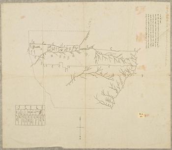
Early twentieth-century maps of the Mongol territories document how the Qing state began to view the steppe as spaces of development. Since 1690, jasaġs had to submit depictions of their domains every decade to the overseeing Court of Outer Dependencies (Ch. Lifanyuan). The years from 1907 to 1910, however, witnessed a sudden cartographic explosion with hitherto unprecedented descriptions of natural resources in the banners (Kamimura Reference Akira, Hiroshi and Akira2005, 14–15). In 1907, authorities in Yeke Mingġan drafted a map for Heilongjiang Province reflecting this shift towards commodification. With brush and ink, the map features natural formations, major roads, princely residences, fixed settlements, a Buddhist temple, and the county seat in Mongol script (see figure 3). Most importantly, the map documents Yeke Mingġan's diminishing dimensions: it conveys the disappearance of the old banner with receding, dotted lines and the permanence of new counties with firm, solid strokes. As the map declared:
Yeke Mingġan Banner intends to release [Mo. talbihu] uncultivated land [Mo. atar] within the old borders, and shrink [in size] to a new border, east to west over two hundred and forty li across, and approximately thirty to fifty li unevenly from south to north. Thus, for the sake of differentiating between the old and new borders, [this] map [Mo. ġajar-un jiruġ] was drawn. (Staatsbibliothek, Berlin Reference Staatsbibliothek and Ostasienabteilung1907)
Map of Yeke Mingġan Banner (1907). Courtesy of Staatsbibliothek zu Berlin, Preußischer Kulturbesitz, Hs. or. 103.

While artificial boundaries in the Mongol banners had always aimed (and failed) to contain seasonal rotations of pastoral nomads during the Qing, the redrawn borders of Yeke Mingġan now held new meanings; they legitimized on paper the divides of pastoral versus agrarian, communal versus private, and Mongol versus Chinese lands that were already forming on the ground (Lee Reference Lee1970, 123).
Despite the loss of their rangelands, Mongol aristocrats thought that they benefited economically from “opening up” their holdings under the New Policies. These elites had become heavily dependent on an expanding system of exchange: they smoked tobacco, drank tea, and wore silks, all purchased from Chinese merchants. To offset financial losses, Mongol nobles thus began to rent and sell communal pastures. They continued to maintain a right to collect rent (Ch. Mengzu, Mo. Mongġol düriyesü) on former banner land from tenant farmers until 1938 (Hirokawa Reference Saho2005, 93–120). Yeke Mingġan and Heilongjiang Province divided the rent so that 45 percent went to the personal coffers of the jasaġ, 35 percent funded the local reclamation office in Babai, 15 percent went to the overseeing land bureau, and 5 percent maintained the banner administration itself (DBDX 2007, 134:408–9).
The commodification of land in Yeke Mingġan accelerated under the new jasaġ, Baljinima, Bagmedorje's son, who reserved less than one-quarter of the banner as “public land for herding” to support “the livelihood of Mongols” (Xu Shichang [1911] Reference Shichang2004, 2.1.20, 2.2.36; Zhu Reference Qiqian1909, 16). In 1905, however, provincial surveyors found that just across the Huyur River to the north, in what would become Keshan, people from outside the banner were privately tilling the land and evading payment to the provincial administration (DBDX 2007, 129:155–60). Baljinima was taking in all of the revenue, rather than just half as decreed by law. Additional agents went to confirm the illegal situation, but Baljinima blocked them at the riverbank (131:130–35). Baljinima's economic straits became obvious a week later when he asked Governor Cheng Dequan for permission to sell the northern bank of the Huyur River in order to repay 12,400 taels to a Zhang Yonghe (131:111–12, 191–93). In pocketing two times the revenue, the jasaġ’s situation mirrored that of other Mongol nobles who used reclamation to finance their increasing debts.
The reclamation that had started with Bagmedorje led to a sinking spiral of renting and selling Mongol lands in order to rescue banner finances, but these pastures had been the very source of economic wealth for the area. Less land meant fewer herds and a diminished income; as debts mounted, so too did the pressure to rent or sell property, and this cycle would begin anew. Mongols short on cash living along the Namur and Huyur rivers sold their allotments to Chinese merchants to buy wares, quickly immiserating themselves. Without land to graze their animals, these herders lost their source of income and two to three hundred of them disappeared into the mountains. Still others took up coolie labor (Minami Manshū tetsudō keizai chōsa kai 1935, 24–25, 69).Footnote 11 Briefly in 1929, the remaining Oirats in Yeke Mingġan expressed their frustration with the shrinking pasturage by arming themselves with sticks and staves and rioting against the local administration. Government assistance did little to counteract the rising structural inequalities stacked against nomadic livelihoods (Bo and He Reference Shaobu and Xuejuan2001, 444–45).
Settler colonialism dislocated earlier populations by bringing in new, permanent communities (Gottschang and Lary Reference Gottschang and Lary2000, 43–63). In the Republican era, the new national government continued to encourage migration to Manchuria in order to align the ethnic limits of the Chinese nation-state with the geographical borders of the former empire. Of all the migrants moving to the borderlands, refugee populations proved the most vulnerable to what they called “the vomiting yellow water disease,” given their economic straits and transient nature. Starting in 1909, famine victims from Hubei moved to Keshan's vicinity with government assistance, followed by those from Henan and Shandong in the next decades (DBDX 2007, 140:429–31; 142:345–49; 149:407–13; 150:21–25, 81–84, 453–55). Refugees often worked whatever land, typically of poorer quality, that had been abandoned by others. Whenever disease broke out, the reclamation bureau, rather than condemning the homesteads, responded by demoting the tracts to third-class status, whose discounted price would lure migrants anew (Wan and Zhang [1932] Reference Fulin and Boyin1992, 1:449). The mysterious disorder around Keshan would vanish after its inhabitants fled, reappearing only when others took up residency. Eruptive cycles of disease and displacement persisted in these populations because no local community endured long enough to warn newcomers.Footnote 12
Keshan Disease also heightened anxieties over gender imbalance, already a demographic problem in settler society. Farming communities on the soy frontier consisted of multigenerational families and their male tenant workers, and thus featured disproportionately more men than women. In hamlets later sampled by Japanese doctors in Keshan, there were three to five men for every two women (Abe Reference Toshio1937, 354). The skewed ratio meant that in the 1930s, families still could command very high bride prices for their daughters. The cost of marriage for young homesteaders in this region was prohibitively expensive compared to the rest of China (Lattimore Reference Lattimore1932, 270–72). In fact, many men in Keshan remained too poor as tenant workers to marry (Manshū kokuritsu Kokuzan nōji shikenjō 1937, 125). The scarcity of women drove human trafficking, as brokers transported daughters of impoverished families from provinces like Zhili or Shandong to sell to single men in Heilongjiang (Ransmeier Reference Ransmeier2017, 293; Shan Reference Shan2014, 21). Because men already outnumbered women, “vomiting yellow water disease” only heightened the gender disparity in settler society. Chinese sources described affected areas as “bachelor villages” (Ch. guangguntun) and “streets of broke lineages” (Ch. duanjiajie) (Wang Reference Kejian2003, 3). One folk song of the time lamented that the disease “moved into Wangxiantun, stoked cooking fires, leaving wives dead and children scattered, only single men remained” (Sun Jianping Reference Jianping1992, 710). The village vernacular narrated the effects of disease as a loss of wives and mothers in service to the family system.
While settler colonialism acted as a quick financial fix through quantifying, commodifying, and privatizing land, it undermined the territorial integrity of Mongol banners. Yeke Mingġan's borders were drawn and then redrawn to accommodate land sales, so much so that by 1915, the year in which Keshan came onto the map, the surface area of the banner shrunk to one-twentieth of its size in the eighteenth century and half its size since the late nineteenth century (Bo and He Reference Shaobu and Xuejuan2001, 434–35; Kōankyoku chōsaka 1939, 300). By the 1930s, 90 percent of the population in and around Keshan reportedly was comprised of settlers from Shandong, with a small minority of Mongols who had adopted agriculture, to the extent that Japanese researchers could no longer discern who was “Chinese” and who was not (Keizai chōsa kai 1935, 120). Four thousand Mongols were concentrated in the banner proper, but in its surrounding former territories, they became nonexistent: only nineteen Mongols out of 200,000 residents in Keshan County; five out of 280,000 in Baiquan County; eight out of 94,000 in Yian County; and ten out of 60,000 in Kedong County (Kōankyoku chōsaka 1939, 344, 379, 416, 452; Minseibu chihō shi 1934, 198). When Japanese occupiers established Manchukuo in 1932, they excluded Yeke Mingġan and three other banners from their newly demarcated autonomous province for Mongol and Tungusic minorities, in which they forbade land reclamation (Manzhouguo zhengfu gongbao 1932). As examined in the next section, Japanese planners elevated agriculture as the industrial mode of production in Yeke Mingġan and throughout the “former Mongol lands” (Ja. kyū Mōchi) cut out of this autonomous province.
Soybeans and the Making of an Agrarian Heartland
Japanese imperialism reconfigured local relationships to land and market. It created an extractive periphery to meet the global appetite for food, fuel, and fertilizer. With Mongols migrating out of Yeke Mingġan, the cultivation of soybeans in particular replaced pastoral nomadism as the primary means of livelihood. Rather than nullify land sales by aristocrats like Bagmedorje and Baljinima, the Japanese occupation authorized them in order to make Manchukuo into the “granary of Asia” (Manchuria Daily News 1939, 1). To match international demand in the 1920s, Keshan turned towards “small-scale intensive cultivation,” a practice that exerted greater pressure per unit of soil to produce more soybeans (Lattimore Reference Lattimore1934, 93). As the agricultural yield per unit of land increased, so too did the crops’ intake of minerals in that soil. Following this line of logic, the rates at which plants absorbed selenium far outstripped the earth's ability to replenish this element. Such geochemical changes, as current medical literature argues, manifested themselves in the declining quality of the nutrition of Keshan's residents, ultimately leading to selenium deficiency disorders.
The soybean industry stood at the core of agricultural development in this region. This legume had multiple functions in the early twentieth century. Soybeans nourished humans and animals as food and fodder with their high protein content. Oil extracted from the seed acted as an industrial lubricant, solvent, cleaner, and coating agent, whereas the residual cake ended up as a valuable fertilizer for farmers. Soybeans carry elevated amounts of nitrogen needed for fertilizer since they host the symbiotic bacteria Rhizobia, which fixes nitrogen from the atmosphere in the nodules of their root system. The legume not only enriches the surrounding soil as it grows, but once compressed as bean cake, it also fertilizes fields elsewhere around the world.
Because Japan itself needed more nitrogen to push its agricultural output to increasingly ambitious levels, it began to rely heavily on exogenous sources of this chemical element. Japanese reliance on soybeans grown in Manchuria, including the Mongol territories, began in the late nineteenth century. From 1893 to 1903, Japan's importation of Manchurian soybean cake as fertilizer leapt from 25,000 tons to 200,000 tons. This surge translated into a jump in both rice and silk yields on the archipelago (Higuchi Reference Higuchi, Batten and Brown2015, 148). Soybean cake overtook herring fertilizer as the leading commercial source of nitrogen for the country after the Russo-Japanese War. In describing this voracious dependency on nitrogen, Toshihirō Higuchi calls Japan “an organic empire” where soybeans reconstituted the archipelago's metabolism in the early twentieth century. As Higuchi writes, “the agricultural core sucked up the organic material while transferring the environmental costs of its production to the colonial frontier.” Japan avoided “biogeochemical crisis” by constantly expanding its overall pool of nutrients with an influx of nitrogen from its colonies (140).
The global desire for this legume as a cheap source of organic fertilizer, vegetable oil, and animal feed drove Chinese migrants to push the boundaries of the soy frontier into the woodlands and rangelands. From 1909 to 1930, they increased soybean acreage in Heilongjiang from 15 to 38 percent of the total land under cultivation. During this decade, Heilongjiang may have supplied about 40 percent of the world's soybeans and exported over 90 percent of its crop to foreign markets (Shan Reference Shan2014, 73). As these statistics indicate, homesteaders undertook rapid and expansive reclamation to meet international demand. Migrants engaged in slash-and-burn methods by setting fire to the steppe and incinerating tall grasses and brush. They planted soybeans to enhance soil quality before sowing other kinds of crops (Heilongjiang sheng dang'anguan and Heilongjiang sheng minzu yanjiusuo 1985, 328–29). One county gazetteer from northern Manchuria noted that local farmers knew about the ability of soybeans to transform the “barren soil” without needing manure because the “bacteria on their nodules could absorb free nitrogen elements in the air” and thus generate fertilizer. Growing grains, such as millet or sorghum, before soybeans would cause “uneven damage” to the land because they would “extract nutrients from the soil immediately” (Sun and Song Reference Quanfang and Jingwen1929, juan 11, 4). Farmers then added soybeans to their crop rotation once every third or fourth year to replenish the exhausted earth with nitrogen (Hisatake Reference Kaneshizu1921, 15–23; Komine Reference Kazuo1991, 189–90; Yasumori Reference Matsunosuke1923, 2, 17–21). In clearing boreal and pastoral landscapes, this kind of reclamation stripped Manchuria of half its foliage and disrupted wildlife habitats (Fukao Reference Yōko, Ayumu and Yōko2009, 6–7; Irie Reference Hisao1937, 29; Nagai Reference Risa, Ayumu and Yōko2009, 22).
Even though Japan had yet to occupy the region formally, it had already become complicit before 1931 in expanding this soy frontier through railroad imperialism. At the turn of the twentieth century, railroads initially built by Russia reoriented the geography of agricultural extraction. Chinese traders in the decades before had relied on carts in the winter and junks in the summer to carry produce from further inland. Most notably, the Liao River conveyed shipments of soybeans from South Manchuria to the port of Yingkou (Reardon-Anderson Reference Reardon-Anderson2005, 171–88). In 1898, however, the first Japanese company, the Mitsui zaibatsu, began to compete with these small, independent Chinese firms in the soybean sector using capital from the Yokohama Specie Bank. The Mitsubishi zaibatsu and oil manufacturers Hōnen and Nisshin soon joined in purchasing soybeans from native brokers and shipping them via rail to Dalian, which soon overshadowed Yingkou for foreign export (Yasutomi Reference Ayumu, Ayumu and Yōko2009, 296). Mantetsu took over the southern trunk of the Russian-owned Chinese Eastern Railway in 1906 and, within a decade, also started to entice business away from the northern trunk, which had dominated long-distance freight in the hinterlands beyond Changchun, including Yeke Mingġan. While the Chinese Eastern Railway incentivized its route from Changchun to Vladivostok via Harbin by offering cheaper fares, Mantetsu undercut that commerce with comparable rates and efficient operations along its track from Changchun to Dalian. Allured by Dalian, a warm-water port with significant international traffic, local dealers in North Manchuria carted Harbin-bound soybeans to Changchun to load onto Mantetsu trains instead (Matsusaka Reference Matsusaka2001, 134–35). Dalian and Vladivostok each shipped 323,000 tons of soybeans per year in 1917, but the fates of these two ports could not be more different in the midst of the Russian Civil War: by 1920, soybean exports from Dalian soared to 710,000 tons whereas those from Vladivostok declined to 32,000 tons (Wolff Reference Wolff2000, 247). Japanese capitalism and imperialism worked in tandem to subvert Russia's position and intensify soybean production in ways that drew selenium out of places like Keshan.
The year 1930 marked the peak production of soybeans in Manchuria. While the legume lost out to synthetic compounds as the chief commercial fertilizer within Japan, foreign demand for soybeans—distilled as vegetable oil for industrial purposes—had soared. During this commodity craze, Mitsubishi, Mitsui, Hōnen, and Nisshin facilitated trade and transport of soybean products overseas from Manchuria. These corporations profited at the expense of large-scale Chinese dealers whose businesses were abolished by the Manchukuo state in 1933 (Nakai Reference Nakai2000, 226). By this point, Manchukuo was producing over four million tons of soybeans per year, its largest crop by weight. Keshan devoted over 90 percent of its agricultural output by weight to soybeans, millet, and wheat. All of these crops came from just 30 percent of Keshan's surface area, or about 300,000 acres (Keizai chōsa kai 1935, 126). Germany became the largest importer of the legume, so much so that it sought to sever its dependency on what pundits called “the Nazi bean” in 1933 and switch its supply from Manchuria to the Balkans (Proctor Reference Proctor1999, 157). International demand dropped during the global depression, compelling Japan to shift soybean processing towards livestock fodder, with most of it still for export (Nagata Reference Hisajirō1935, 1, 40).
In the years after the founding of Manchukuo, economic planners intervened in the soybean industry to prepare the Japanese empire for war against the Soviet Union. They disavowed railroad imperialism and global trade in favor of autarkic isolation and authoritarian developmentalism. Japanese administrators enacted this vision through the establishment of a “controlled economy” (Ja. tōsei keizai), remaking the client state into its fascist form through anti-capitalist rhetoric, corporate partnerships, limitations to the free market, and government-mandated production targets (Young Reference Young2017, 292). The Five Year Plan, announced in 1937, was a defining feature of this controlled economy. Since soybeans had saturated the market, the Five Year Plan instead focused on increasing yields for grains. Trade had become so lopsided in favor of this legume that Mantetsu researchers urged, through a study specifically on Keshan, to diversify the food supply by planting more sorghum, millet, and maize (Mantetsu, Shinkyō shisha chōsa shitsu 1940, 1, 40). Of the 300,000 acres under cultivation in Keshan at this time, soybeans accounted for 27 percent, millet for 19 percent, wheat for 12 percent, barley for 8 percent, and sorghum for 3 percent of the land (Manshū kokuritsu Kokuzan nōji shikenjō 1937, 2).
In 1940, the client state reorganized village communities—like those of Keshan—into agrarian cooperatives (Ja. kōnō gassakusha), ordering Chinese farmers to store their produce in collective granaries. Soybeans, among other staple foods, became subjected to strict regulations on processing, distribution, exportation, and price, all managed by the Manchuria Agricultural Products Public Corporation (Ja. Manshū nōsan kōsha), a new quasi-governmental organization that had replaced intermediary traders. Through this company, Japanese occupiers imposed “grain requisitions” (Ch. liangshi chuhe) on agrarian cooperatives. In Longjiang Province, where Keshan was located at that time, they seized 30 to 47 percent of the harvest at artificially low prices from 1940 to 1942 in order to feed the home islands (Zhongyang dang'an guan et al. 1991, 590–91). Despite the move from market capitalism to a controlled economy, imperial Japan still expected Manchukuo's agrarian heartland to shoulder a significant part of its output in grains and legumes, and Keshan, as one of its constituent counties, likewise bore the environmental effects of these demands.
Keshan's change from a mixed economy to an almost exclusively agricultural one during this period had direct implications for the diets of its tenant farmers. Pastoral nomadism lent itself to meat- and dairy-based diets that had greater amounts of selenium. During the late Qing, Oirats in Yeke Mingġan began to settle permanently, no longer moving back and forth between winter and summer pastures. Herding still remained their primary source of sustenance, supplemented by fishing and hunting (Ao Reference Leqi1991, 36). A late nineteenth-century compendium showcases Oirats in Yeke Mingġan as specializing in the dairy products of butter, milk tofu, and dried milk skin (Xu Ke [1917] Reference Ke1928, 6374). One British visitor to the region repeated the stereotype that “Mongols are very bad farmers, their scanty cultivation being full of weeds, so they depend on the Chinese … for luxuries and even the necessaries of life” (James Reference James1888, 310). Despite this reliance on outsiders for crops, as Owen Lattimore (Reference Lattimore1934, 92) pointed out, “the diet of the Mongol, with its meat and milk, and grain got by trade, … [was] more varied and more healthy than that of the Chinese.” In this transition from herding to farming, diets declined in the diversity of their provisions and origin.
Nitrogen and selenium cycles collided in Keshan. Since these residents exported soybeans and wheat to urban centers in Manchukuo and beyond, selenium deficiency would have posed little danger to outside consumers with a diverse diet drawn from multiple markets. For those living in Keshan and eating the mineral-depleted produce of their farms, however, the nutritional risk was substantial. Homesteaders in Keshan consumed similar food regardless of social standing, and nearly all of it was local: gruel or pancakes made from millet and tofu made from soybeans (Keizai chōsa kai 1935, 224). They also grew and ate cabbages, cucumbers, eggplants, onions, radishes, and squash (Manshū kokuritsu Kokuzan nōji shikenjō 1937, 2, 168). A high meat and dairy intake can stave off selenium deficiency (Office of Dietary Supplements 2016). The diet of wealthier farmers in Keshan nevertheless consisted of about 3.7 percent meat and fish, a proportion that dropped to 1.7 percent for poorer laborers. Much of that protein supply derived from black hogs raised on their own property and slaughtered for the three holiday meals of the year (Manshū kokuritsu Kokuzan nōji shikenjō 1937, 109, 111). Soybean imperialism had transfigured the relationship between humans and the earth in Yeke Mingġan, and in so doing, rerouted the paths of economic exchange: food that had circulated at both the banner and regional level now left the site of extraction to be consumed in other parts of the empire and beyond. The diffusion of agricultural products from Keshan on the global market thus left a concentrated imprint on the local environment.
Endemic Disease under the Japanese Occupation
Keshan Disease received significant interest from the Japanese medical community as a part of a broader movement towards monitoring the health of Japan's subjects through field research and hygiene campaigns. The principal investigator of the 1936 study, Abe Toshio, and his team looked into the possibility of pneumonic plague, insect-infested wool, poisonous gas, contaminated foods, and toxic plants, while also considering drinking water and the cold weather. After autopsying a victim's heart and discovering it unnaturally engorged, the Japanese doctors diagnosed Keshan Disease as cardiomyopathy, a deterioration of the heart muscle. Abe posited one possible etiology: fūdobyō 風土病, a combination of characters meaning climate and sickness, often translated from Japanese as “endemic disease,” a category that also included goiter and Kashin-Beck Disease (Abe Reference Toshio1937, 363). The connotations of fūdobyō contrasted with a common Chinese term for endemic disease, difangbing 地方病, whose combination of characters suggests a strictly geographic meaning. A contemporary dictionary defined fūdobyō as “a disease occurring within a fixed region, attributed to factors of climate and natural features” (Daijiten 1936, 22:68). The physical impact of Keshan and Kashin-Beck Disease, as manifested on the bodies of patients, in turn, contributed to conceptions of colonial difference by Japanese scientists who attempted to explain these disorders.
By the 1930s, fūdo—as explored in the philosophy of Watsuji Tetsurō—also could mean climate as “an expression of subjective human existence” rather than an external, objective natural environment, from which an entire people's attitudes, values, and culture would derive (Watsuji [1935] Reference Tetsurō and Bownas1998, v).Footnote 13 Watsuji revived older meanings of fūdo, from the work of seventeenth-century intellectual Wang Fuzhi, who asserted that differing geographic conditions between Chinese and their “barbarian” neighbors to the north generated contrasting constitutions, leading to disparate customs, behaviors, and natures (Chen Reference Chen, Mullaney, Leibold, Gros and Vanden Bussche2012, 74).Footnote 14 For Watsuji, fūdo served as the human expression of space. The discourse of fūdo fostered a form of environmental difference between Japanese and the Other in an empire whose ideology lacked stark racial distinctions. By extension, the term fūdobyō allowed scientists to bring bodies into the empire and calibrate their health, but under the assumption that those bodies—Japanese or Other—were fundamentally not all that different from each other. Anyone could succumb to fūdobyō. The difference, these doctors believed, lay in the environments from which inhabitants drew their sustenance and how they chose to do so. Japanese immigrants to Manchukuo, unlike the local population, could escape Keshan Disease if they followed preventative measures of modern hygiene.
Research on Keshan and Kashin-Beck Disease took place within an imperial campaign of documenting and experimenting with fūdobyō in Manchukuo (Kihara Reference Hitoshi1940, 92). Ruth Rogaski (Reference Rogaski, Che Leung and Furth2011, 141) evocatively describes the Japanese occupation as “vampires in plagueland” because Japan's biomedical programs operated among “truly terrifying atrocities” perpetrated by germ warfare projects like Unit 731. Teams of physicians from Manchukuo Medical College—which included Chinese, Manchu, and Korean interns—along with Mantetsu staff and military guards traveled the countryside. To research Keshan and Kashin-Beck Disease, they conducted house-to-house interviews, examined up to several hundred subjects per site, and checked the composition of water in dozens of wells. Doctors photographed, x-rayed, and measured their patients, as well as tested their blood and urine for any abnormal symptoms. They also visited several local elementary schools to survey children, who often exhibited signs of illness first. Professors designed trials for disease prevention where they dispensed cod liver oil, yeast pills, and nightshade to patients and observed their effects (Takamori Reference Tokio1940). The results of these studies, both in the field and in the laboratory, appeared in medical journals in Xinjing and Tokyo, in Chinese and Japanese, and established the hinterlands as a field laboratory for endemic disease research.
When studying Kashin-Beck Disease, the scientist Hieda Kentarō stumbled through villages where the proportion suffering from the condition ranged from 60 to 72 percent. He described afflicted locals living “primitive lifestyles” that had caused them to have “the bone structure of a gorilla” (Hieda Reference Kentarō1937, 8). One of Hieda's photographs, included in his report, arranged patients with Kashin-Beck Disease in a line by descending height, naked except for a loincloth. They stood next to a clothed, healthy subject—one of the Japanese doctors—so that readers could compare the full extent of their condition. Hieda aimed to construct a metric to show how the disease progressed over time, and yet the photograph now evinces how Japanese investigators objectified their patients in the name of colonial science (Hieda Reference Kentarō1935, 18).
Japanese scientists blamed civilizational practices drawn from local environments in sickening colonial bodies (Miura Reference Un'ichi1934). One professor from the Manchukuo Medical College, Hara Tooru, subscribed to the theory that carbon monoxide poisoning caused Keshan Disease. He critiqued Chinese farmers for “hibernating and sleeping in rooms with kangs”—or heated platforms for sitting and reclining—while “continuously breathing in air containing carbon monoxide day and night” during the bitter continental winters (Hara Reference Tooru1939). Hara saw how the extreme climate shaped these heating habits, yet he condemned borderland residents for not understanding the importance of ventilation.
Because women of childbearing age faced the greatest risk of Keshan Disease, their bodies became objects of concern within imperial discourse. As seen in Japanese reports, the client state took great interest in the bio-political regulation of health and illness, and birth and death among Chinese women, much like their Korean counterparts (Yoo Reference Yoo2008). Hara and his colleagues conducted physical examinations of female patients, some of them mere hours away from dying from Keshan Disease. Doctors ran the cold metal of the stethoscope against the skin of their subjects, listening to their heart beat, their blood course, and their lungs expand and contract. They pressed with their fingers to feel for the heart muscle, tapped for edemas, pricked them with needles, exposed them to x-rays, and wired them to electrocardiograph machines (Takamori Reference Tokio1940). The physicians ordered thirty-four-year-old Mrs. Nie (née Gao), among other women in Keshan, to remove her top and lower her trousers. Nie closed her eyes, then turned her face and body three-quarters towards the camera as they photographed her bare-chested. Hara later took a pen to Nie's image to mark out the internal effects of Keshan Disease across her breasts. Nie also sat for a chest x-ray, lifting her arms into the air. In the negative space of the x-ray below her ribcage, Hara drew axes and triangles to measure the expansion of Nie's heart muscle (Hara Reference Tooru1939). All of these detailed test results, along with patient photographs and x-rays, appeared in print back in the metropole, in the Tokyo New Journal of Medical Practice (Ja. Tokyo iji shinshi). Keshan Disease therefore underscored not only gender divides between men and women in an already unequal settler society but also ethnic hierarchies between Japanese and Chinese. Through these invasive procedures, Japanese male doctors furthered the production of docile bodies and the reproduction of subjects for the client state. Their subjectivities stripped down to their raw, physical capabilities, Chinese women experienced the double jeopardy of patriarchal power, locally and imperially.
Endemic disease endangered the very foundation of the imperial project in the borderlands by unsettling potential Japanese settlers as well. One doctor urgently pressed for continued research on fūdobyō because he saw it as “a significant obstacle to the Japanese development of Manchuria-Mongolia” (Miyabe Reference Isao1936, Reference Isao1937, Reference Isao1938). The Manchukuo government organized an Immigrant Hygiene Research Conference (Ja. Imin eisei chōsa iin kaigi) in 1936 to discuss the ensuing crisis. As covered in the Manchuria Daily News, military doctors and medical faculty found that:
The climate [Ja. fūdo] and endemic diseases in Manchuria differed greatly from Japan. The inability to adapt to the [continental] lifestyle would impede the health of immigrants and their descendants, making it not difficult at all to anticipate the inevitable failure of the entire immigrant enterprise. (Manshū nichinichi shinbun 1936)
Personnel responsible for the migration of Japanese “pioneers” to Manchukuo worried that these newcomers would “become alarmed and flee back to the homeland” if they had arrived without being warned of the presence of endemic disease in the area. The conference highlighted the “extreme importance of research on indigenous hygiene” in order to dissuade Japanese migrants from adopting what they deemed as unsanitary local customs, such as poor air circulation, improper food storage, and contaminated drinking water (Manshū nichinichi shinbun 1936). In this way, the practices of endemic disease prevention helped reify civilizational differences between Japanese and Chinese settler populations.
Classifying Keshan Disease symptoms made it possible for Japanese doctors to identify the condition along the soy frontier. After studying results from electrocardiograms and x-rays, Japanese physicians concluded that the sudden onset of symptoms that had struck Keshan represented only a fraction of all cases. They argued that Keshan Disease was a more gradual condition that had affected hundreds more people than just those who abruptly died in 1935. Throughout the late 1930s and early 1940s, the soy frontier continued to record hundreds of casualties as “heaps of bodies” (Wang Reference Kejian2003, 3).Footnote 15 The structures of colonial science, in terms of its ability to make observations, conduct experiments, and disseminate its results through an empirical language, then, formalized the existence of a disease already long familiar to the Chinese population.
After the communist takeover, Keshan Disease persisted as a pretext for the state extension of bio-political control into the everyday lives of its citizens. The new government intervened by sending disease prevention teams into minority areas with little medical access in order to set up hygiene centers. Daur and Orochen communities near Qiqihar, for example, learned about the “preventative measures” of air circulation, toilet insulation, and domestic repairs from these initiatives (Zhuronga, Maduertu et al. Reference Zhuronga, Dao, Yingdong and Yongzhang1958, 21–22; Zhuronga, Mojinchen et al. Reference Zhuronga, Wudamu and Weijun1961, 44). As the Great Leap Forward ramped up agricultural production, Keshan itself experienced more devastating crises that claimed thousands of lives (Sun Jianping 1992, 710). In 1959, 1964, and 1970, the worst years on record, Keshan Disease claimed 1,400 to 3,000 lives out of more than 8,000 cases per annum throughout China (Fordyce Reference Fordyce and Selinus2005, 397). Only after residents living in low-selenium areas began to take dietary supplements did Keshan Disease largely vanish from the land.
Conclusion
The disappearance of Yeke Mingġan as a banner and the emergence of selenium deficiency disorders within its constituent counties call attention to the deleterious effects of settling the nomadic borderlands. Surveying and selling the land confirmed the idea of a wilderness in the Mongol territories, and one in need of development. In the area that would become Keshan, homesteaders in turn displaced herders, converting steppe into farms and depleting the earth of its selenium. Chopping the woodlands, draining the marshlands, and burning the rangelands all simplified the variegated terrain into monocultures of grain and legumes, so much so that in 1917, the Mantetsu researcher Itō Takeo marveled that: “I imagined northern Manchuria to be wild lands, but the scenery that drew near from the windows of the train revealed field after field of farms on the horizon. Where did these farmers come from to work the land? I had an eerie feeling about it all” (Itō [1964] Reference Takeo and Fogel1988, 32). The very railway Itō rode on (and his employer no less) played a crucial role in reorienting local ecologies into imperial margins. Under the Japanese occupation, the soybean industry intensified ecological processes, where the little selenium that was drawn out of Keshan eluded its residents for a destination beyond its horizons. Japanese imperialism converted circulatory pastoral ecologies into extractive agrarian peripheries to devastating effect. Through land reclamation, industrial capitalism, and economic planning, the Mongol territories experienced an anthropogenic process so intensive that it altered their geological composition. Soybeans offered the green promise of returning nitrogen to the soil, but just as likely hastened the yellowed demise of their cultivators by removing selenium from the earth.
If selenium deficiency set the conditions for the rise of endemic disease on the soy frontier, then it exposes the layers of colonial difference between imperialists and indigenes—Mongol herders versus Chinese farmers, and then Chinese farmers versus Japanese occupiers—in how they interacted with their environments. Ironically, what had made Chinese living in the region “civilized” during the late Qing and Republican regimes—that is, the conversion of “wasteland” into farmland through the settler enterprise—had uncivilized them in the eyes of the Japanese. Cultivating crops in soil deficient in certain elements, then consuming that harvest, ultimately produced those sickly bodies that so fascinated colonial scientists and officials.
By bringing attention to the understudied Mongol territories, a layered narrative of Keshan goes beyond environmental histories bound by the nation-state to reveal the corporeal costs of settler colonialism. After the dissolution of the Japanese empire, Heilongjiang Province dismantled Yeke Mingġan completely, merging it with Fuyu County. This act, undertaken in 1948, did more than just efface the banner's existence off the map; it obscured the environmental transformation from “wasteland” to farmland in Yeke Mingġan that brought about this crisis of selenium. When considering the Mongol territories, previous scholarship often overlooked the fact that regardless of whether Japanese saw their empire as a blank map upon which to chart a colonial utopia, they still had to reckon with the hauntings of borderlands past. The migrant legacies of both the Qing and the Republic lingered in this space, and Japanese newcomers often negotiated older meanings of imperialism and nationhood within a new order of the occupation.
Acknowledgments
I wish to express my appreciation to the two anonymous referees for their attentive and engaged critiques, as well as to JAS Editor Vinayak Chaturvedi for shepherding the article through review. Mark Elliott, John Kim, Ian Jared Miller, Micah Muscolino, Ruth Rogaski, Jonathan Schlesinger, Eric Schluessel, Victor Seow, Hannah Shepherd, and Norman Smith read and discussed this essay with me at various stages of its creation. Burged Kered, Sodbilig Shirnuud, and Yanagisawa Akira offered their expertise and time. The work also benefited from insights by colleagues in the Manchurian Environment Workshop at the University of British Columbia, the Agrarian Studies Program, and the Environmental Anthropology Collective at Yale University. The Fulbright IIE Program, Japan Foundation, and Social Science Research Council provided funding for archival research.