

Introduction
Haughton crater on Devon Island in the Canadian Arctic is an ~30 km diameter, Miocene-aged impact structure that has been extensively used as a Mars (and lunar) analogue over the past 20 years to address questions including impact processes (Osinski et al., Reference Osinski, Lee, Spray, Parnell, Lim, Bunch, Cockell and Glass2005), astrobiology (Cockell et al., Reference Cockell, Lee, Osinski, Horneck and Broady2002) and as a Mars and lunar analogue (Lee and Osinski, Reference Lee and Osinski2005; Osinski et al., Reference Osinski, Léveillé, Berinstain, Lebeuf and Bamsey2006). It has been the research location for a wide range of space-related operations (Lee et al., Reference Lee, McKay and Matthews2002), including human factors (Binsted et al., Reference Binsted, Kobrick, Griofa, Bishop and Lapierre2010), field robotics (Barfoot et al., Reference Barfoot, Furgale, Stenning, Carle, Enright, Lee, Angeles, Boulet, Clark, Kovecses and Siddiqi2010) and operations (Clancey et al., Reference Clancey, Lee and Sierhuis2001).
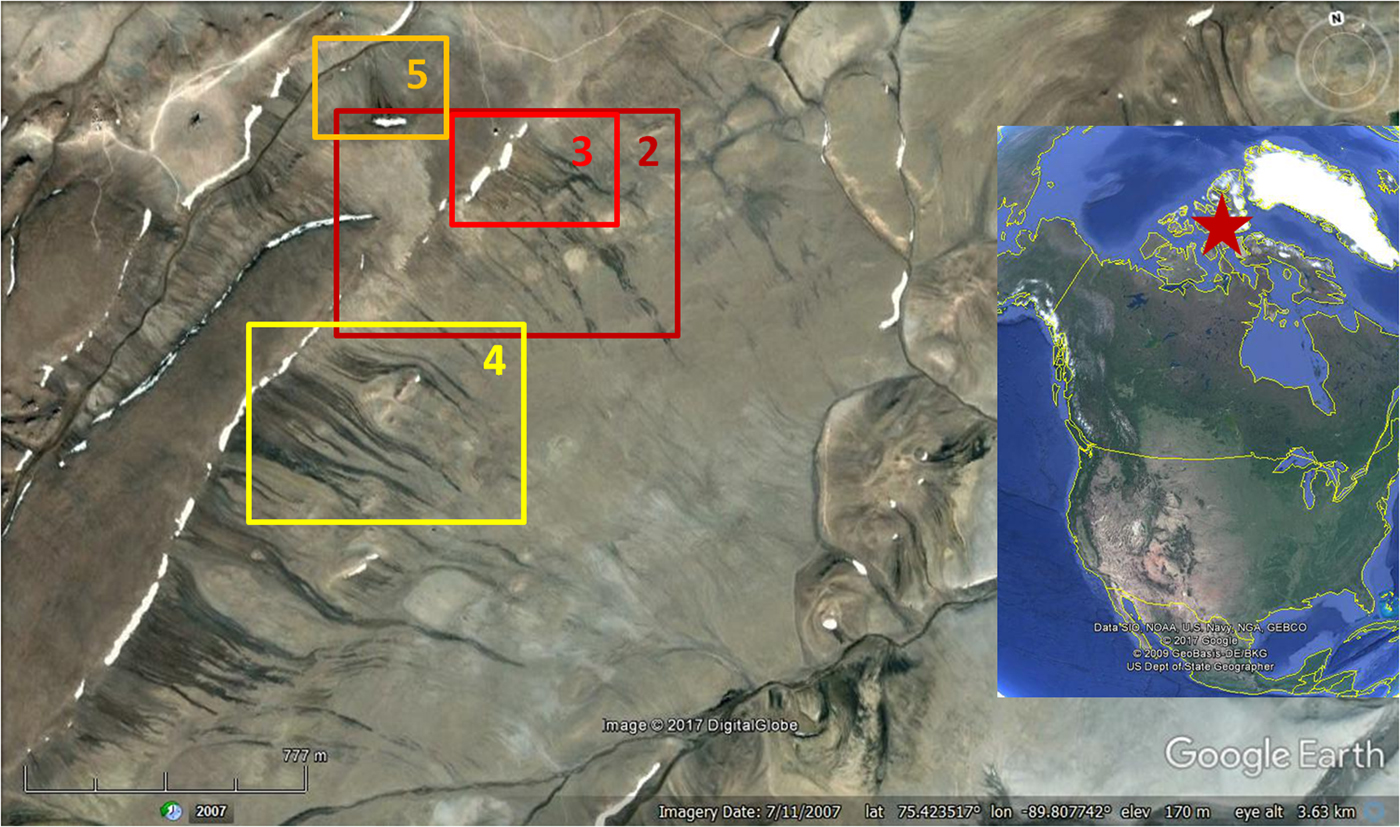
Here we report on small scale, semi-seasonal slope melt water streaks (melt streaks) formed on the crater walls that we observed during a 33-day occupancy of the Flashline Mars Arctic Research Station (FMARS) as part of The Mars Society's Mars 160 project. FMARS is located on the north-west rim of Haughton crater, known as Haynes Ridge, at 75°25′52.44″N 89°49′23.63″W (Fig. 1). These we argue are potential analogues for a range of short-lived, dark-toned Martian slope features, including recurring slope lineae (RSL and slope streaks) that may, or may not, be related to ephemeral surface water activity. As such they will provide opportunities to explore a range of research questions to do with surficial Martian processes, astrobiology and planetary protection.
Study area on the NW rim of Devon Island. Numbered boxes refer to locations of subsequent Figs 2–4. Devon Island location is shown as an inset.

Description
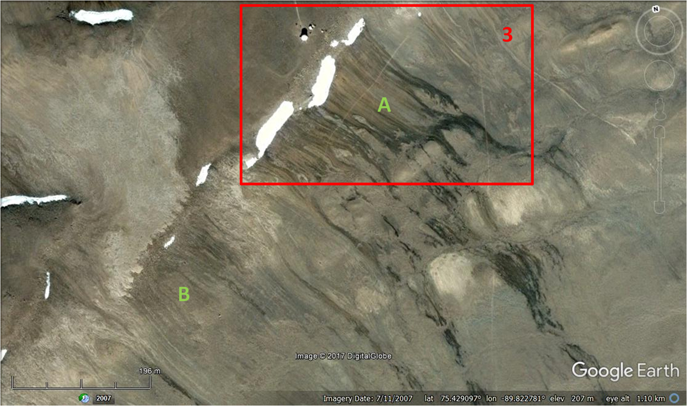
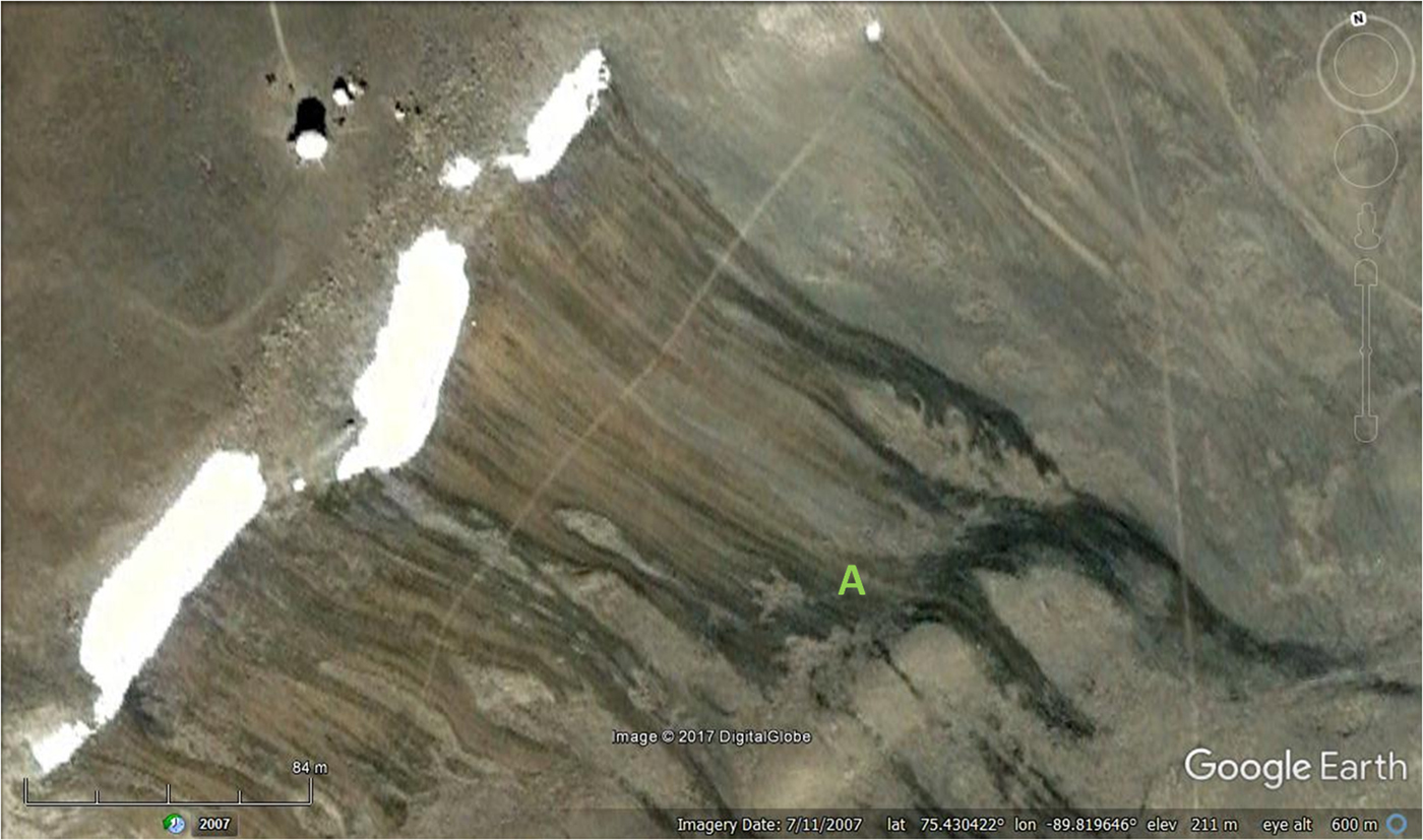
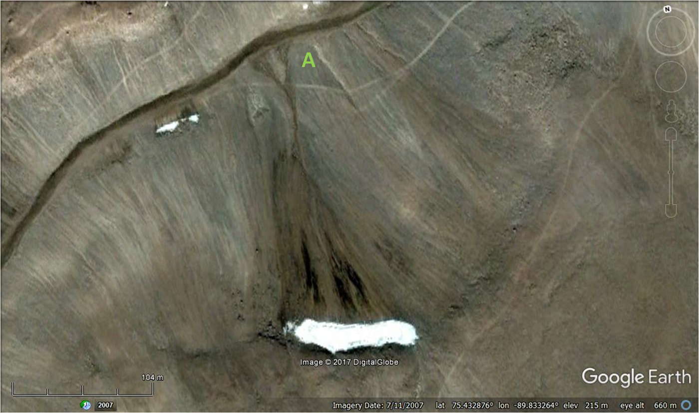
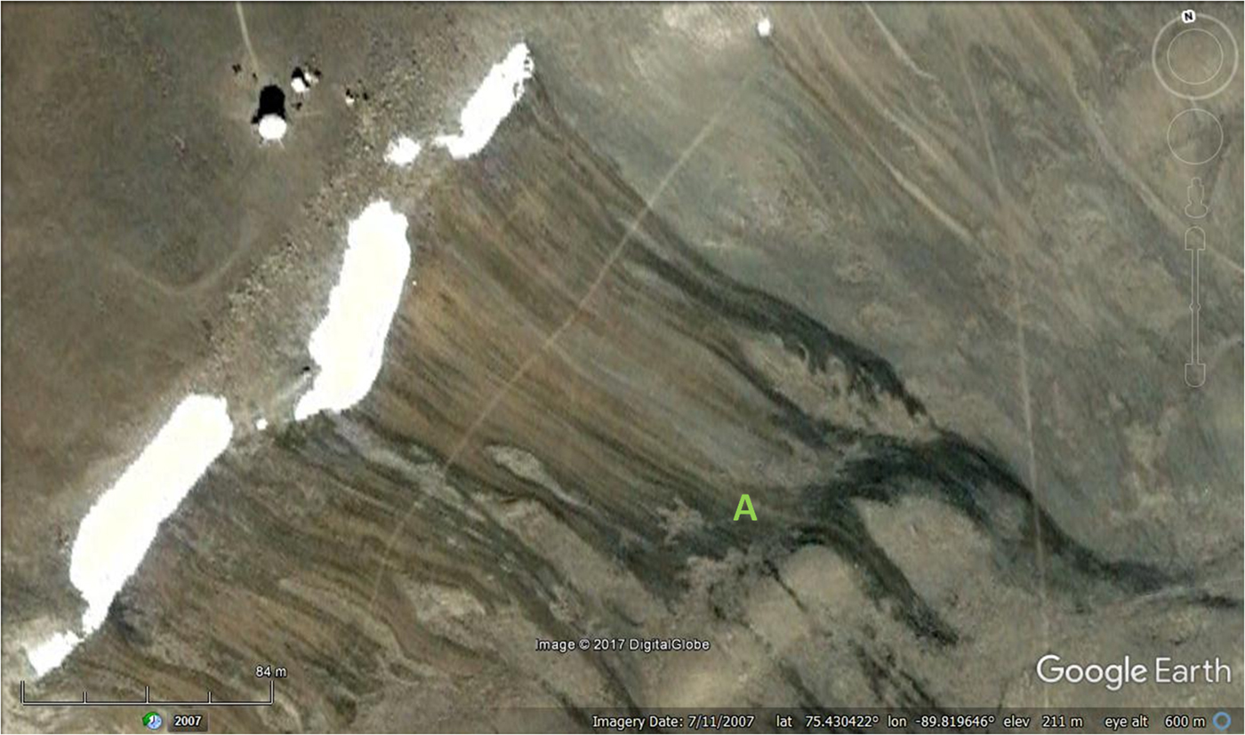
Snow melt features have been previously identified in UAV imagery from Haughton crater (Pisanich et al., Reference Pisanich, Young, Plice, Lau, Ippolito and Lee2004) but not described in detail. The examples we describe are common along the NW rim of Haughton Crater (Haynes ridge) and elsewhere. They consist of dark, often linear streaks, mostly straight but sometimes deflecting around obstacles. The melt streaks start in long-lasting snow patches and generally narrow down slope. Most have simple terminations (Fig. 2). Occasionally the termini branch in a distributary-like fashion. Some of the melt streaks are associated with the tops of solifluction lobes with further discharge from their toes (Fig. 3). In one case the streaks become a stream that terminates in a small fan (Fig. 4). Those measured by us (using Google Earth imagery from the study area) are typically a few hundred metres long and a few metres wide. Mean slope over the length of the streaks was 5.07°, with a range of 2.31–8.87° (Table 1). Overall longer streaks had lower slopes, because they extended from the top of the ridge to the lower slopes. Slopes were concave, with the steepest parts near the crest of the ridge just below the snow patch alcove. Short slope segments exceeded 20° angles in the nivation hollows formed by snow patches. The steepest segments were poorly defined because of the blocky nature of the regolith allowed surface water to drain thus preventing steak formation.
NW rim of Haughton crater. (a) Active dark melt streaks, (b) inactive and faded streaks through loss of former snow patch, the prime water source. Area shown in Fig. 3 is marked.

Active melt streaks and solifluction lobes (A) below F-MARS station (top left).
Melt water streak forming small channel and terminal fan.

Measurements of melt streaks along Haynes Ridge (N = 51)

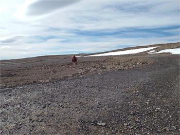
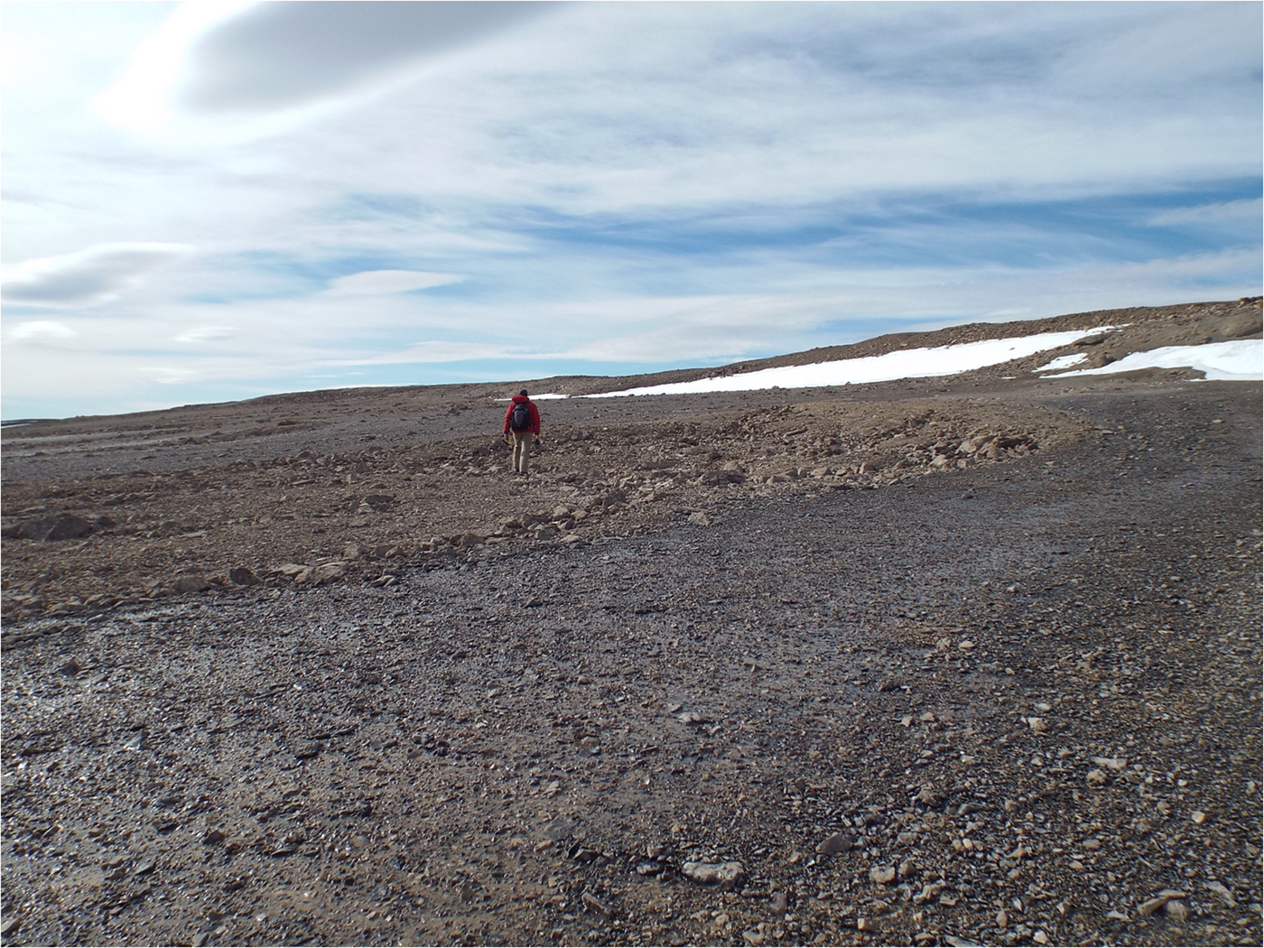
At ground level the melt streaks are composed of trails of trickling melt water that flow between and sometimes over stony ground. Stone coverage varies from 100 to 50% with any intervening fine-grained soil being fully saturated. The dark colour comes from a combination of the wetted surface and black microbial biofilms on both rocky regolith and intervening fine-grained (silt and fine sand) material (Fig. 5). Permafrost occurred at depths of less than 60 cm.
Melt streak formed by drainage from snow patches. Wetted surface colonized by dark biofilm.
The melt streaks observed by us resemble features described as water streaks at other high-latitude locations (Levy and Fountain, Reference Levy and Fountain2011; Langford et al., Reference Langford, Gooseff and Lampkin2015; Head et al., Reference Head, Marchant, Dickson, Levy and Morgan2007) and appear distinct from gully and gully-like features previously described from Devon Island (Lee et al., Reference Lee, Cockell and McKay2004, Reference Lee, Braham, Boucher, Schutt, Briggs, Glass, Gross, Hine, McKay, Hoffman, Jones, Berinstain, Comtois, Hodgson and Wilkinson2005, Reference Lee, Glass, Osinski, Parnell, Schutt and McKay2006) and other high-Arctic locations (Grasby et al., Reference Grasby, Proemse and Beauchamp2014) because of the near absence of any cross-sectional relief associated with our observed melt streaks.
While sustained, long-term weather records do not exist for Haughton crater or any other site on Devon Island, long-term records do exist for the nearby towns of Resolute (74°41′51″N 094°49′56″W) and Grise Fiord (76°25′03″N 082°53′38″W) on adjacent Cornwallis and Ellesmere Islands, 169 km southwest and 218 km northeast from FMARS respectively.
The meteorological station on Resolute is World Meteorological Organization (WMO) approved and contains WMO certified historical climate averages going back to the 1950s (Environment Canada, 2017). While Grise Fiord has maintained a meteorological record covering the same general period of time, it is not WMO approved and does not have archived climate averages. As Grise Fiord and Resolute are the nearest stations to FMARS, we have used data from these stations as proxies for the period of occupancy of FMARS during the M160 expedition (7 July–9 August 2017). Maximum and minimum temperatures for these two stations are given in Table 2, and show that temperatures during this period are likely to be between −1 and 11°C.
Summary temperature data for 7 July–9 August 2017 for Resolute (https://www.timeanddate.com/weather/canada/resolute, address accessed 29/11/18) and Grise Fiord (https://www.timeanddate.com/weather/canada/grise-fiord, address accessed 29/11/18)

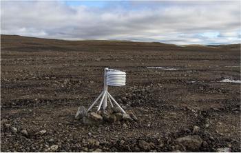
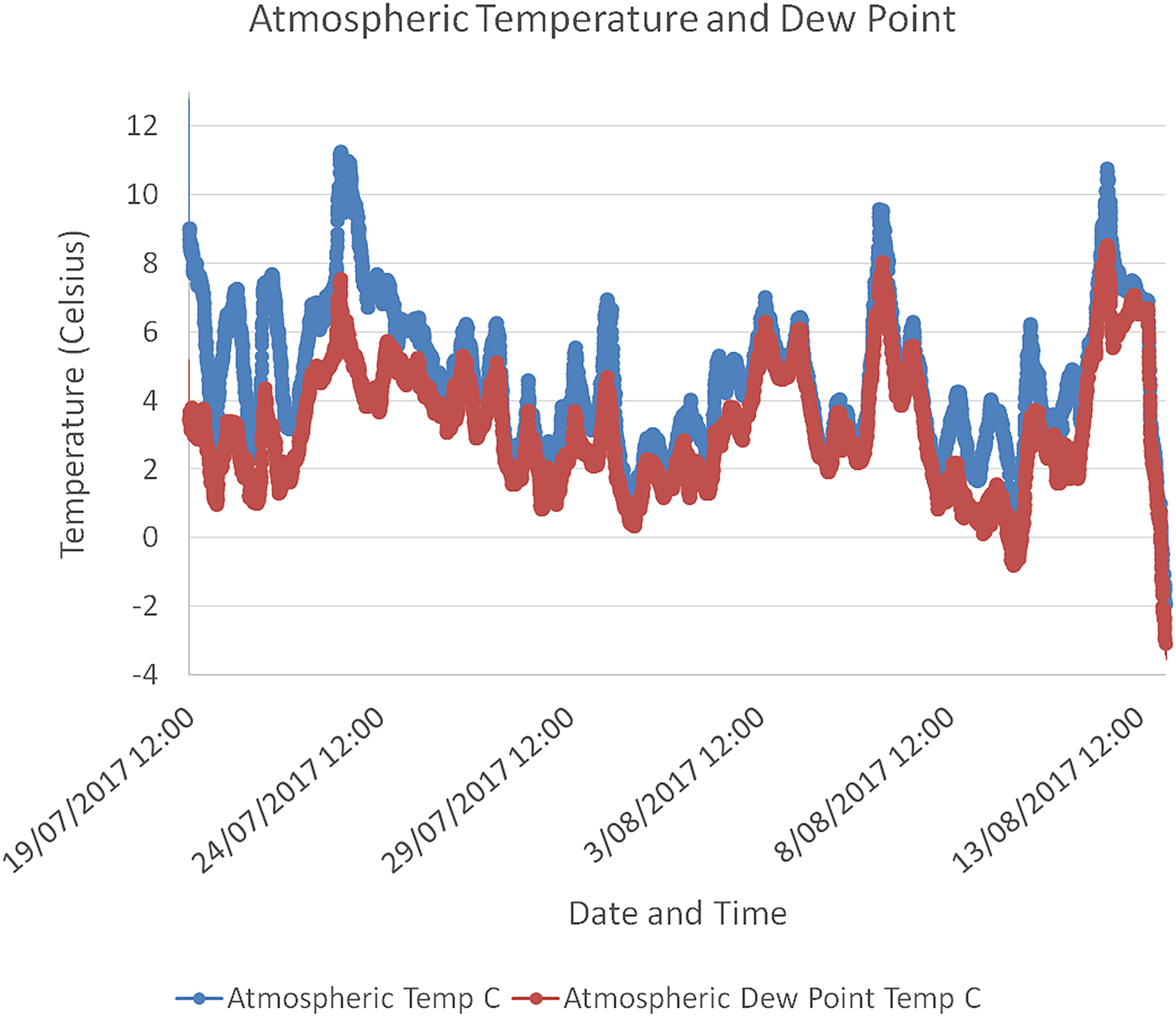
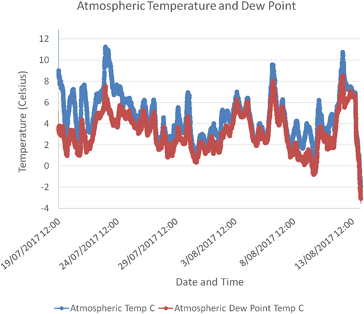
We deployed a Hobo v2 Temperature and Relative Humidity data logger (Fig. 6) to measure ambient atmospheric conditions to serve as a background for the subsurface temperature and soil moisture observations associated with the active layer above permafrost. A daily weather log was maintained and noted the weather conditions at 0800, 1200, 1800 and 2000 h for 29 days. Temperature and dew point data for this period are shown in Fig. 7.
Hobo v2 Temperature and Relative Humidity datalogger at its deployed location just beneath the western rim of the Haughton Impact Crater.

Plot of temperature and dew point measured by the Hobo v2 station at toe of streak during the M160 expedition.
Seasonal changes
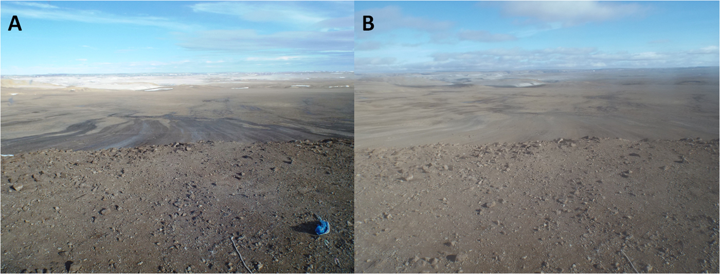
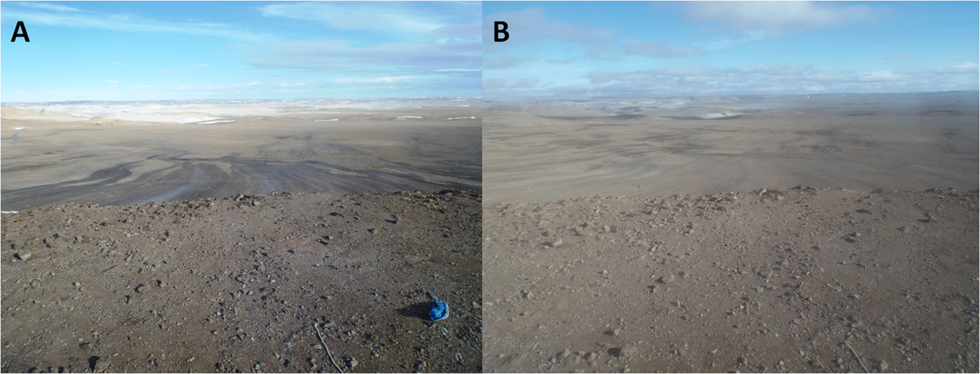
Two types of seasonal lightening of these melt streaks were observed by us and are supported by Google Earth imagery: (1) lightening through drying and (2) lightening through burial by sheet wash. The smaller and more exposed snow patches shrink with the progression of summer and eventually disappear. The dependent melt streaks dry out and lighten in colour (Fig. 2). The dead or dormant biofilms become a light grey, only slightly darker than the uncolonized rock and soil. Sheet wash from rain events transport sediment down the slopes and bury the biofilms beneath a thin layer of silt and sand, this too lightens their colour (Fig. 8).
Short term changes in slope streak expression at location shown in Figure 3. (A) Healthy dark biofilms on slope below F-MARS, 19-7-17. (B) Same area with light coloured biofilms partly dried out and buried by fine silty sand sheet wash, 14-8-17.
Other nearby examples
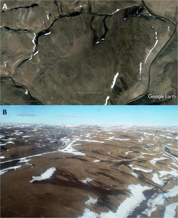
Similar features can be observed from air and in Google Earth imagery in other parts of Devon Island (Fig. 9). These were also darker when melt water was actively flowing from snow patches, and lighter when the show patches had disappeared and both surface and shallow subsurface flow had apparently ceased.
Dark melt streaks on Devon Island away from Haughton Crater. (a) Area north of crater showing dark toned streaks from melting snow patches and light toned inactive melt streaks from areas where snow has now vanished. (b) Area west of crater showing dark active melt streaks from melting snow patches and light toned inactive melt streaks in areas where snow has vanished.

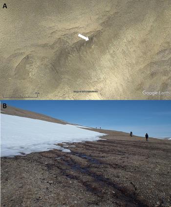
Snow patches are also present on the slopes of Signal Hill, behind the small settlement of Resolute on Cornwallis Island. Dark melt streaks are associated with these. Figure 8 shows a ground level image of melt water emerging from the snow patch forming a dark streak, and a Google Earth image of the area after the snow has melted, illustrating the very light tone of the streak after the snow patch has melted and the water ceased to flow. The melt streaks on the slopes of the nivation hollow were about 30°, and less than 10° on the floor.
Discussion
How do the melt streaks form?
Based on our observations the following preconditions must be met for the melt streaks to form:
• surface temperatures above the melting point
• surface pressures above the triple point (a precondition trivial on Earth but quite important on Mars)
• water source from melting seasonal or permanent snow patch
• slope to allow water flow
• shallow impermeable substrate (bedrock, permafrost) so that water saturates surface
• fine-grained (fine sand or silt) regolith or regolith matrix to retard water infiltration and facilitate biofilm development
The absence of melt streaks on steeper slopes may be attributed to the following factors either singly or in combination:
• Drainage of melt water is too rapid to allow sufficient moisture to accumulate and support biofilm development
• Absence of fine-grained regolith to support biofilm colonization
• Extensively fractured nature of bedrock exposed on slopes results in impermeable substratum (bedrock, permafrost) being too deep to allow surface saturation (Fig. 10).
Fig. 10.(a) Nivation hollow on the south side of Signal Hill, Cornwallis Island, behind Resolute. Arrow shows slightly darker melt streaks where water is still flowing although snow has melted. These are on the slope of the hollow. The melt streaks on the floor of the hollow are largely faded. (b) Ground image of the same nivation hollow, showing show patch against steepest parts of the slope and melt water flowing across the floor, with dark biofilms. Slope angles beneath the snow reach 30°.


Martian slopes
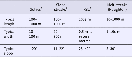
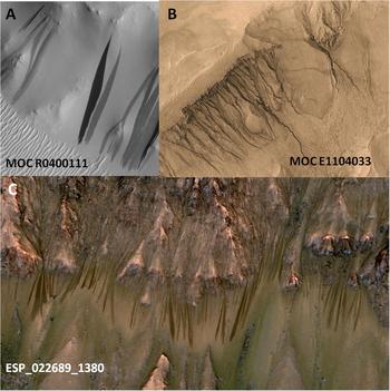
The melt streaks in Haughton crater provide an intriguing comparison to a suite of slope features locally common on Martian slopes. These include gullies (Christensen, Reference Christensen2003) with attendant flows (Malin et al., Reference Malin, Edgett, Posiolova, McColley and Noe Dobrea2006), slope streaks (Edgett et al., Reference Edgett, Malin, Sullivan, Thomas and Veverka2000) and recurring slope lineae or RSL (McEwen et al., Reference McEwen, Ojha, Dundas, Mattson, Byrne, Wray, Cull, Murchie, Thomas and Gulick2011), as shown in Fig. 7. The formation of these features is contested. Gullies and their deposits have been attributed to dry slope processes, although it is likely that Martian gullies, like terrestrial examples, are the result of a range of processes (Hobbs et al., Reference Hobbs, Paull and Clarke2014, Reference Hobbs, Paull and Clarke2017). The dark slope streaks on Mars are predominantly thought to be formed by dry particulate flows (Baratoux et al., Reference Baratoux, Mangold, Forget, Cord, Pinet, Daydou, Jehl, Masson and Neukum2006) but a role for liquid water continues to be suggested (Bhardwaj et al., Reference Bhardwaj, Sam, Martín-Torres, Zorzano and Fonseca2017). Recurring slope lineae have been attributed to wet flows formed from deliquescing salts (Ojha et al., Reference Ojha, Wilhelm, Murchie, McEwen, Wray, Hanley, Massé and Chojnacki2015) but a dry flow formation has also been suggested (Dundas et al., Reference Dundas, McEwen, Chojnacki, Milazzo, Byrne, McElwaine and Anna Urso2017). Characteristics of these features are summarized in Table 3.
Comparison between melt streaks and possible analogous Martian features

1Malin et al. (Reference Malin, Edgett, Posiolova, McColley and Noe Dobrea2006), Christensen (Reference Christensen2003), Hobbs et al. (Reference Hobbs, Paull and Clarke2014, Reference Hobbs, Paull and Clarke2017), Heldman & Mellon (Reference Heldmann and Mellon2004).
2Baratoux et al. (Reference Baratoux, Mangold, Forget, Cord, Pinet, Daydou, Jehl, Masson and Neukum2006), Bhardwaj et al. (Reference Bhardwaj, Sam, Martín-Torres, Zorzano and Fonseca2017), Phillips et al. (Reference Phillips, Burr and Beyer2007), Sullivan et al. (Reference Sullivan, Thomas and Veverka2001).
3McEwen et al. (Reference McEwen, Ojha, Dundas, Mattson, Byrne, Wray, Cull, Murchie, Thomas and Gulick2011), Ojha et al. (Reference Ojha, Wilhelm, Murchie, McEwen, Wray, Hanley, Massé and Chojnacki2015), Dundas et al. (Reference Dundas, McEwen, Chojnacki, Milazzo, Byrne, McElwaine and Anna Urso2017), Edwards & Piqueux (Reference Edwards and Piqueux2016)
All these Martian features have mostly formed on steeper slopes up to 40° for gullies (Heldman and Mellon, Reference Heldmann and Mellon2004), 11–22° for Martian slope streaks (Phillips et al., Reference Phillips, Burr and Beyer2007) and 25–40° for RSL (McEwen et al., Reference McEwen, Ojha, Dundas, Mattson, Byrne, Wray, Cull, Murchie, Thomas and Gulick2011). Their parameters are summarized in Table 3, and compared with the melt streaks described by us (Fig. 11).
(a) MOC image of slope streaks, most recently formed darkest. Characteristic diversion of flows of round obstacles is visible. (b) MOC image of crater wall and gullies, with remnant patches of presumed LDM. (c) HiRISE image of crater wall featuring RSL.

Our features also have some similarities with Martian gullies in their association with surficial deposits of snow and ice, which in the case of the Martian gullies appear to be sourced from deposits of the latitude-dependent mantle (LDM). The LDM is thought to represent dusty snow accumulations formed during the periods of high obliquity (Schon and Head, Reference Schon and Head2012). It was these similarities that drew our attention to them as potential Mars analogue features.
Significant differences also exist between the Haughton slope features and those on Mars. Unlike the Martian LDM-associated gullies, significant erosion from the upper reaches is absent from our examples along with significant deposition in their lower reaches. Furthermore, no association of slope streaks has been noted with the LDM or seasonal ice deposits. While the seasonal nature of RSL is suggestive, to date ‘wet’ formation hypotheses have focused on deliquescent salts, rather than melting of seasonal ice deposits. However multiple processes may produce similar final features on Mars, as they do on Earth. See Phillips et al. (Reference Phillips, Burr and Beyer2007) for such discussion on slope streaks and Hobbs et al. (Reference Hobbs, Clarke and Paull2016a, Reference Hobbs, Paull, Clarke and Roach2016b) for multiple processes producing gullies and valleys.
Mars analogue application
We propose that the dark melt water slope features in Haughton crater and, by extension, elsewhere on Devon and Cornwallis Islands provide potential Mars analogues in at least three potentially valuable ways.
1. As features are known to be formed by water they provide benchmarks to compare with contentious features on Mars, such as RSL and slope streaks, that may, or may, not be water associated. Their similarities and differences may help assess whether or not any of the superficially similar Martian features have formed similarly by melting of surface and/or near surface ice deposits or seeping shallow groundwater.
2. The biofilms associated with the melt streaks may provide insight into the potential habitability for possible Martian biofilms formed in hypothetical microbial communities associated with past or present seasonal melting.
3. By providing a morphologically similar feature to Martian slope streaks and RSL that is associated with water they are a natural laboratory to test issues of planetary protection associated with their study, be it by robotic missions or astronauts.
The Devon Island streaks as features known to be formed by water melt water provide benchmarks to compare with contentious features on Mars, such as RSL and slope streaks. In particular they may clarify whether the categories of RSL and slope streaks are monogenetic or polygenetic in origin (see discussion in Phillips et al. (Reference Phillips, Burr and Beyer2007) for slope streaks and Hobbs et al. (Reference Hobbs, Clarke and Paull2016a) for gullies), with convergence of appearances even though formed by different processes (Phillips, Reference Phillips1999).
Work on these dark microbial films associated with snow melt is, to the best of our knowledge, limited. Lee et al. (Reference Lee, Cockell and McKay2004) noted that cyanobacteria of the Nostoc commune and of the black and probably freeze–thaw tolerant genus Gloeocapsa are more common in areas that receive seasonal snowmelt. While comparable, photosynthetic microbes are not expected on Mars because of the high levels of shortwave UV, the relationship between liquid water and microbial habitats is likely to exist on Mars similar to on Earth (Lee et al., Reference Lee, Cockell and McKay2004).
The dark biofilms may be of assistance to better understanding approaches to planetary protection. Reviews of the relevant protocols have emphasized the importance of liquid water, especially lower salinity liquid water, in defining ‘special regions’ that need a high standard of protection from terrestrial contamination (Rummel et al., Reference Rummel, Beaty, Jones, Bakermans, Barlow, Boston, Chevrier, Clark, de Vera, Gough, Hallsworth, Head, Hipkin, Kieft, McEwen, Mellon, Mikucki, Nicholson, Omelon, Peterson, Roden, Sherwood, Tanaka, Viola and Wray2014). As an example, the identification of possible RSL near the planned track of the Curiosity rover in Gale crater (Dundas and McEwen, Reference Dundas and McEwen2015) led to a reassessment of the route because of planetary protection concerns (Witze, Reference Witze2016) because the rover did not meet the high planetary protection standards required for accessing areas with the potential for surface liquid water. We suggest that the dark coloured melt streaks and their associated biofilms in Haughton crater and elsewhere in the Arctic may provide clues to the possible vulnerability of speculative microbial communities associated with RSLs on Mars to contamination during exploration, and to develop procedures for their study to avoid such contamination
We predict that further exploration of the melt streaks in these contexts may elucidate the formation of these contentious features and provide a better understanding of planetary protection issues, allowing for effect exploration of Mars by both robotic missions and astronauts on the surface.
Conclusions
We summarize our preliminary conclusions as follows:
• Dark melt water slope features in Haughton crater on Devon Island and elsewhere in the Canadian Arctic are formed by biofilms colonizing rock surfaces over which snow melt is flowing from seasonal to semi-permanent snow patches.
• The melt water slope features darken when water biofilms are actively growing as a result of water flow. They become lighter in colour by two processes: when the water flow ceases and the surface dries, or when rain washes light coloured silt over the biofilms. Rain can also wash away remnant snow packs, resulting in reduction or cessation of water flow.
• They are common, seasonally variable and recurring slope features. They may be related to the water streaks that have been recognized in other polar locations in the Arctic and Antarctic.
• As examples of dark recurring slope features known to be associated with water they provide a wet benchmark to compare with Martian slope streaks and RSL that may, or may not, be formed by liquid water.
• The melt streaks may have potential as astrobiological analogues for wet models of slope streaks and RSL.
• They are natural laboratories to study planetary protection issues associated with robotic and astronaut exploration of potential water-related slope features on Mars.
It is our view that these features warrant further investigations in connection with their significance as benchmarks to possibly comparable features on Mars, for their insights into possible microbial habitats as natural laboratories to test issues of planetary protection issues associated with surface water on Mars.
Acknowledgements
This paper would not have been possible without the contribution of our M160 crewmates – Annalea Beattie, Claude-Michell Laroche, Alex Mangelot, Yusuke Murakami, Aunshree Srivastava and Anastasiya Stepanova. We are grateful to Robert Zubrin and the Mars Society for organizational and financial support and vision, Paul Sokoloff in his role as co-PI and Arctic expert, Vincent Chevrier for advice on environmental conditions and processes, and Chris McKay, Kathy Bywaters and Charles Cockell for input into biological matters. We also thank the input of the journal editor and the reviewers.