Introduction
With a Mediterranean climate and 700–900 millimetres of annual precipitation, the Shahrizor Plain—which lies in Sulaimaniyah Province, close to the town of Halabja—is one of the most fertile areas of Iraqi Kurdistan. This preliminary report documents new archaeological fieldwork in this relatively unexplored part of the Middle East. The focus of these new investigations is on the later prehistory of the Shahrizor, between the sixth and fourth millennia b.c. In broader regional terms this corresponds to the long period between the establishment of Neolithic farming settlements and the emergence of the earliest cities, although the nature of these processes in Iraqi Kurdistan remains very poorly documented.
In neighbouring parts of the Middle East, the periods in question have traditionally been divided into a series of broad cultural phases (Halaf, Ubaid, Uruk), reflecting associated changes in material culture and settlement patterns. In recent decades the utility of these broadly defined phases for any wider reconstruction of social evolution has been repeatedly brought into question. Partly this is the result of sustained research in areas such as the Syrian Euphrates and southern Turkey, bringing to light the complexity of local developments in village, and later urban, life and leading to a wider reformulation of key research questions (summarised in Baird Reference Baird and Potts2012; Campbell Reference Campbell and Potts2012; Carter and Philip Reference Carter and Philip2010; Schwartz and Akkermans Reference Schwartz and Akkermans2003).
Owing to protracted periods of warfare and political instability, Iraqi Kurdistan remained largely isolated from these wider research agendas and debates in the later twentieth century. A primary aim of the current project is to help rectify this situation by building up a detailed record of human settlement and associated material culture in the later stages of the Neolithic and Chalcolithic periods, situated within a wider archaeological exploration of the surrounding landscape. Given its agricultural potential, and its location astride key passes into the western Zagros and the Diyala Valley, the wide open plain of the Shahrizor seemed a logical place to begin.
The sites and their geographical setting
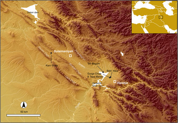
Gurga Chiya and Tepe Marani are small, adjacent mounds in the southern part of the Shahrizor Plain (Fig. 1). Viewed from the site of Gurga Chiya, the surrounding plain is framed by a number of prominent landmarks. To the southeast lies the town of Halabja, beyond which the foothills of the Zagros Mountains rise toward the border between Iraq and Iran. To the northeast the view is dominated by the site of Bakr Awa, a major ancient settlement (Miglus et al. Reference Miglus, Bürger, Heil and Stepniowski2011; Reference Miglus, Bürger, Fetner and Mühl2013), beyond which runs the modern road between Halabja and Sulaimaniyah. To the north-west lies the Darband-i Khan Dam Lake, established on the former headwaters of the Diyala River in the 1950s, where the waters of the Tanjero and other, smaller tributaries once joined the Sirwan (Upper Diyala), then flowing south through the Hamrin mountain range to join the Tigris below Baghdad. Numerous archaeological mounds of widely varying sizes are visible in the vicinity, extending east across the Shahrizor beyond Bakr Awa towards the highlands, and west up to the fringes of the lake, beneath which an estimated seventy archaeological sites, as well as the remains of some twenty early twentieth century villages, are now submerged (see Mühl Reference Mühl2010; Reference Mühl2013).
Gurga Chiya and Tepe Marani in their regional setting (map created by A. Bevan)

Gurga Chiya and Tepe Marani lie outside the area periodically flooded by the lake, in a section of the plain that has been under increasingly heavy cultivation since the late 1960s, when tractors were introduced, followed in the 1970s by centralised redistribution of arable land between the surrounding villages. An estimated century ago a waterwheel and mill—of which no trace is now visible—were located on Gurga Chiya together with a number of houses, the foundations of which were long ago cleared for ploughing (Abdlqadir Shadi, pers. comm.). The modern village of Gurga Chiya lies a short way to the north-west, along a road leading to the steep mound of Tell Qortas, on the margins of the Darband-i Khan Lake. Prior to the dam's construction the region provided rich fishing yields, and during the period of British Administration (1920–32) a bridge had crossed the Sirwan where it flows downstream past the lower reaches of the Qara Dagh range (ibid.). Prominent archaeological sites in the area around the Darband-i Khan Lake were used for military purposes during the Iran-Iraq War (1980–88). Perimeters for gun emplacements are visible as raised earthen banks on the summits of ancient tells, and long mounds of earth—used as cover for advancing units—are widespread.
The foothills of the nearby Zagros Mountains were once heavily forested. Pollen sequences from the wider Irano-Anatolian region indicate relatively slow commencement of tree growth after the end of the last Ice Age, with marked acceleration in the middle Holocene (from c. 4000 b.c.; Asouti and Kubukcu Reference Asouti and Kubukcu2014). Sheep, goat, and cattle are currently grazed in the immediate vicinity of the sites, making use of a wadi that erodes the eastern profile of Gurga Chiya, and wild boar are still occasionally hunted in the uplands. The history of sheep and goat herding in this region extends back to the initial domestication of these species (Zeder and Hesse Reference Zeder and Hesse2000; Matthews et al. Reference Matthews, Matthews and Mohammadifar2013). Both ancient and modern herding practices in this region are often characterised as “transhumant”. This, however, is a gloss on the complex history of interactions between pastoralists, villagers, and urban centres on the fringes of the Zagros (see, for example, Fredrik Barth's characterisation of the Jaf tribe's seasonal movements between Bakr Awa and the Penjwin mountains in the early-mid twentieth century; Barth Reference Barth1953; and also Potts Reference Potts2014 for a broader historical view). Altaweel et al. (Reference Altaweel, Marsh, Mühl, Nieuwenhuyse, Radner, Rasheed and Saber2012) describe the wider geographical setting of the Shahrizor Plain in further detail, and review major historical sources for the region's development over the last five millennia.
Archaeological research in the Shahrizor Plain
The history of modern archaeological fieldwork in this area falls into two parts: survey and excavation by Iraqi archaeologists in the context of dam construction (1951–61), and work undertaken by the Sulaimaniyah Directorate of Antiquities and Heritage over the past decade. International projects have been active for some years, including large-scale excavation on the high tell and “lower city” of Bakr Awa (Miglus et al. Reference Miglus, Bürger, Heil and Stepniowski2011; Reference Miglus, Bürger, Fetner and Mühl2013), where the known range of archaeological strata extends from the Uruk period to Islamic times. The earlier prehistory of the Shahrizor was known from surface survey and limited exposures at a handful of sites (summarised in Altaweel et al. Reference Altaweel, Marsh, Mühl, Nieuwenhuyse, Radner, Rasheed and Saber2012: 18; and see also Mühl Reference Mühl2013). In 1960 a large sounding at Tell Begum, north of Darband-i Khan, revealed floors and house foundations dated by associated pottery to the Late Neolithic and Early Chalcolithic periods (Hijjara Reference Hijjara1997: 127–29). Further evidence of these phases derives from recent work by the Sulaimaniyah Directorate at the sites of Greza and Tanjero, north-west of Arbat, and new work by the University of Leiden has recently commenced at Tell Begum (Nieuwenhuyse et al. Reference Nieuwenhuyse, Odaka, Kaneda, Mühl, Rasheed and Altaweel2016).
The potential for further research on the prehistory of the Shahrizor Plain has been greatly clarified by a regional survey undertaken since 2009 by Mühl (Reference Mühl2010; Reference Mühl2013), which laid foundations for current excavations at the Early Neolithic site of Bestansur (Nieuwenhuyse et al. Reference Nieuwenhuyse, Berghuijs and Mühl2012; and work now ongoing by the Central Zagros Archaeological Project, University of Reading). Mühl's survey, which identified ceramics of the Chalcolithic period at Gurga Chiya, also provided the basis for the Shahrizor Prehistory Project—a collaboration of the UCL Institute of Archaeology, UCL-Qatar, and the Sulaimaniyah Directorate of Antiquities and Heritage—which includes excavations there and at Tepe Marani.
Gurga Chiya and Tepe Marani: the sites and their location
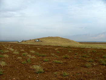
Gurga Chiya (Figs. 2 and 3) is a steep-sided, multi-period mound covering approximately one hectare and rising twelve metres above the surrounding field systems. Traces of “hollow ways” (cf. Wilkinson Reference Wilkinson2003) departing from the site to the west and north are clearly visible on CORONA satellite images, but their dates of formation are unknown (Mühl, pers. comm.). Significant quantities of pottery, recovered from slope wash deposits on the north and south faces of the mound during the pilot season (Fig. 3, Trenches GC-A and GC-C), indicate the existence of a Late Bronze Age settlement. Our work has since focussed on the mound's west face (GC-E and GC-F), where deposits of the Uruk and Late Chalcolithic periods, and associated architecture, were uncovered close to the surface of the mound.
Gurga Chiya, viewed from the south-west (photograph by G. Brereton)

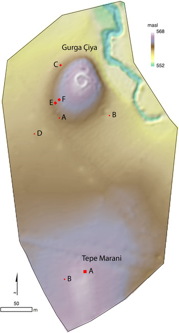
Digital Elevation Model of Gurga Chiya and Tepe Marani showing location of main trenches (TM-A, TM-B; GC-C, GC-E, GC-F) and test pits (GC-A, GC-B, GC-D; map created by A. Bevan; edge of image = edge of area surveyed)

Tepe Marani is a low mound lying less than half a kilometre south of Gurga Chiya. Its shallow profile and location on a natural rise make it almost imperceptible to the naked eye. The contours of the site, as revealed by DGPS survey (Fig. 3), cover c. 0.7 hectares. It has been extensively ploughed in recent decades and Late Neolithic (Halaf-related) pottery is relatively abundant on the surface, including painted wares. Pottery of this kind was rarely noted in recent surveys of the Shahrizor Plain (see Mühl Reference Mühl2013: 83–90), but the preliminary results from Tepe Marani indicate that remains of this period, including architecture, may in fact be preserved on shallow mounds that have survived the impact of modern farming.
Gurga Chiya and Tepe Marani are located in a part of the Shahrizor that might seem inauspicious for prehistoric research. It is here that the Tanjero River, having first followed a more constrained passage between the Pir-a Magrun and Beranan Dagh ranges, enters a wide plain fanning outwards towards the Zagros foothills. Accordingly the accumulation of alluvial deposits is likely to be most heavy in this eastern part of the plain, burying prehistoric sites below some metres of sediment. However, the uniformity of the present-day plain—with its rich, deep soils—is deceptive: a product of two or more millennia of stable soil formation, hastened by deforestation, intensive grazing, and extensive agriculture.
Deep geological cores drilled in the vicinity of Gurga Chiya indicate a complex mosaic of early and middle Holocene environments. Arable soils would have been much less evenly distributed and were most likely interspersed with grassland, woodland, areas of marsh, and riparian gallery forest. Especially significant, in terms of site preservation, is the emerging evidence for Pleistocene terraces overlooking perennial and seasonal watercourses. This suggests the former existence of an undulating land surface with markedly raised areas, where evidence for early human settlement has escaped the effects of sedimentation (Altaweel et al. Reference Altaweel, Marsh, Mühl, Nieuwenhuyse, Radner, Rasheed and Saber2012: 4–8). Gurga Chiya and Tepe Marani, and also nearby Bakr Awa, appear to be located on terraces of this kind.
To date, two phases of archaeological fieldwork have been undertaken at Gurga Chiya (GC) and Tepe Marani (TM). During a pilot season (4–9 May, 2012) the latter site was identified, test trenches were excavated at Gurga Chiya, and a DGPS survey of both sites was commenced by Bevan (Fig. 3). A longer season (2–27 May, 2013) saw the establishment of two trenches on Tepe Marani (supervised by Brereton) and four trenches on and around Gurga Chiya (supervised by Shepperson). Their purpose was to identify the location of late prehistoric deposits and test for the possible extension of the mound below the modern alluvium. One test trench dug into the cultivation, approximately 50 metres to the west of the tell (GC-D), produced a small assemblage of chipped stone, as well as highly eroded fragments of coarse pottery and bone fragments at a depth of c. 2 metres, but no extension of the mound was detected in this direction.
On the mound itself, and on Tepe Marani, sampling strategies were implemented for the recovery of environmental remains and micro-artefacts. These included on-site dry sieving (to 5 millimetre mesh), flotation, and fine sorting of heavy residues (down to 1 millimetre). On-site conservation of archaeological materials was undertaken by Ravaioli in the nearby village of Bakr Awa using locally sourced materials; and interviews were conducted with local residents concerning the recent history of the area. Results of this work are summarised below by broad chronological phases: Late Bronze Age, Chalcolithic, and Late Neolithic; comparisons are drawn with known sites and assemblages across the wider Middle East to provide a context for our findings; and we conclude with some preliminary interpretations and suggestions for further research.
The Late Bronze Age at Gurga Chiya
In the course of identifying areas with accessible prehistoric strata, significant quantities of Bronze Age pottery and chipped stone were recovered from Gurga Chiya. Their original occupation horizon appears to be high on the mound, and the excavated levels largely consist of redeposited material distributed across much of the lower part of the site. This is particularly evident in GC-C, located on the lower (north-western) slope, where Bronze Age ceramics were found within a deep deposit of mixed debris washed down from higher up the mound. Below this a series of further substantial deposits produced medium-large sherds of similar date. The concentration of debris suggests a phase of rapid building decay, possibly following the abandonment of all or part of the site.
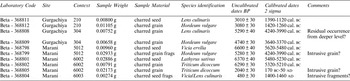
Extending into the corner of Trench C, and directly below these pottery-rich redeposited layers, was a well-preserved oven or clay-lined hearth with heavily fired walls. Sampling of its contents produced a rich botanical assemblage, described further below. Single lentil and barley seeds from within this feature yielded radiocarbon dates calibrated to 1390–1120 cal. b.c. at 2 sigma (Beta-368811, 3010 ± 30 b.p.) and to 1420–1260 cal. b.c. at 2 sigma (Beta-368812, 3080 ± 30 b.p.) respectively (Table 1). The ranges are relatively long owing to the nature of the calibration curve at this point, but when combined can be slightly narrowed to 1393–1227 b.c. at 2 sigma (OxCal v.4.2.3). Sealed below the oven and an associated mud-brick wall or platform were two further layers of slope-wash containing further Late Bronze Age pottery and chipped stone tools.
AMS dates from Gurga Chiya and Tepe Marani, processed at Beta Analytic

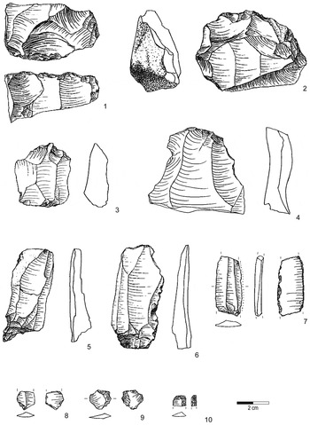
In total some forty-nine pieces of chipped stone could be securely ascribed to the Late Bronze Age horizon at Gurga Chiya. A sample is illustrated in Figure 4. All but three are made from (presumably local) chert and fine-grained limestone, among them two fragments of blades including a sickle blade (Fig. 4: 6,7), two retouched flakes, one large denticulate (Fig. 4: 2), one borer (Fig. 4: 5) and one awl (Fig. 4: 3), one fragment of a flake core, with several debitage platforms, and one core tablet (Fig. 4: 1). Three obsidian artefacts were found: a backed blade fragment (Fig. 4: 10), a micro-burin (Fig. 4: 8) and one splintered piece (Fig. 4: 9). The rest of the assemblage consists predominantly of flakes, several flake-blades, fragments of nodules and angular shatter.
Chipped stone artefacts of the Late Bronze Age from Trench C at Gurga Chiya (drawn by H. Sosnowska)

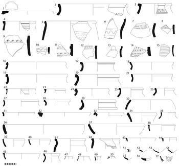
Most of the Late Bronze Age pottery from Gurga Chiya was recovered from GC-C, with quantities also recovered from the test pit on the southeast side of the mound (GC-B). As described above, the majority was redeposited in slope-wash originating from a formerly substantial LBA occupation on top of the mound. Similar ceramic material was associated with the in situ tannur and built feature near the bottom of GC-C. Recovered vessels consist chiefly of large- and medium-sized storage jars in a soft brown fabric with medium to fine chaff temper (Fig. 5: 1–35), many of which bore finger-impressed or incised decoration on appliqué cordons. Sieves of the same ware were also found (Fig. 5: 57) as well as bowls of various sizes (Fig. 5: 36–40). Also present was a less common cream ware (Fig. 5: 41–46) used for medium sized jars. Small rims and knob-bases, likely to be associated with jars and/or beakers, were found in a fine brown fabric (Fig. 5: 47–55).
Late Bronze Age pottery from Gurga Chiya: 1–40, 56–57: brown fabric with and grey core and medium chaff temper. 41–46: cream fabric with medium chaff temper. 47–55: fine brown fabric

Formal parallels for the knob bases, sieves, and jars with incised and impressed decoration are found at LBA sites across northern Mesopotamia, from Yorgan Tepe in the east (Starr Reference Starr1937–39, pls. 63–68, 77, 95–96) to Tell Brak in the west (Oates et al. Reference Oates, Oates and McDonald1997, fig. 184: 57–60, fig. 194, fig. 212: 614–15, fig. 213: 627). Mühl (Reference Mühl2013: 172–98) provides further discussion of LBA ceramic assemblages east of the Tigris, and outlines their wider social and economic contexts. Absolute dating of the assemblage derives from radiocarbon samples, obtained from the tannur in GC-C (early fourteenth to late thirteenth centuries b.c.; see above).
The Uruk Period at Gurga Chiya
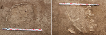
Two 4 × 4 metre trenches (E and F), located 4 metres apart on the western slope of Gurga Chiya, produced a sequence of artefact-rich deposits and structural remains spanning the fifth and fourth millennia b.c. In both cases a poorly preserved upper horizon, truncated by ploughing, contained the bottom parts of fired clay ovens (Fig. 6) of which there were four in total, ranging from 50 to 60 centimetres in diameter at point of survival. The lack of any kind of built structure around these oval installations suggests they were constructed in pits dug into older deposits. One contained bevel-rim bowl fragments and no later pottery has been identified in their fills. We tentatively conclude that these features date within the Chalcolithic, and are only slightly later than the Middle Uruk deposits into which they were dug.
Uruk-period ovens with fired clay walls in the upper levels at Gurga Chiya, Trenches E (left) and F (right)

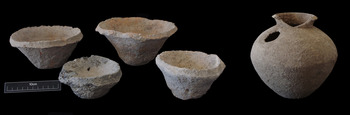
The higher of the two trenches (GC-F) contained a dense deposit of Middle Uruk ceramics, chipped stone and other material covering much of its surface. This deposit lay below the oven layer, and directly above a stone foundation wall running between the east- and north-facing sections. The pottery deposit contained bevel-rim bowls of widely varying sizes and fabrics (Fig. 7: left; Fig. 8: 1–3) many of them complete or near complete, suggesting this material lay at its original point of deposition. Given the hypothesis that these bowls may have been used to manufacture pot-baked bread (most recently, Goulder Reference Goulder2010, with further references), it is tempting to see an association between the dense pottery deposit and the overlying ovens; although the lack of any direct stratigraphic association must be borne in mind.
Left: Bevelled-rim bowls. Right: spouted jar from the Middle Uruk deposit at Gurga Chiya (Trench F; photograph by G. Brereton)

Material from the Middle Uruk pottery scatter and associated levels (Trench F). 1–3: BRBs with coarse vegetal and grit temper; no. 3 has one very large grey grit. 4–6: grey burnished ware with medium-fine vegetal and grit temper. 7–9, 13–15: red slipped and burnished ware with medium-fine vegetal and grit temper. 10–12: fine brown ware; no. 12 has scraped bottom

Globular jars (Fig. 8: 4–5) with rounded or everted rims were also common within the Middle Uruk deposit. They were typically made in grey burnished wares, sometimes with pierced nose-lugs and a rope-incised cordon or slashed incisions running around the shoulder. Also present were straight-spouted vessels (Fig. 7: right; Fig. 8: 9–10), fine cups (Fig. 8: 12) and red slipped and burnished jars with rope-impressed banding and applique nose lugs (Fig. 8: 7). The assemblage as a whole compares well with that from the Middle Uruk levels (5–7) at Sheikh Hassan (Boese Reference Boese1995), suggesting a mid-fourth millennium date (i.e., Late Chalcolithic 3–4). The same deposit also produced a small number of sherds showing closer affinities to northern Ubaid wares (not depicted). These most likely derive from earlier phases of occupation at Gurga Chiya. This probability is also reflected in two radiocarbon dates taken from the soil matrix of the large pottery deposit. While one gives a Middle Uruk/LC 4 date calibrated to 3630–3400 cal. b.c. at 2 sigma (Beta 368809, 4740 ± 30 b.p.), consistent with the majority of the pottery, the other is considerably earlier at 4240–3950 cal. b.c. at two sigma (Beta 368808, 5290 ± 40 b.p.), suggesting the presence of residual material brought up from lower layers, as is also the case in the upper fills of GC-E.
Of the chipped stone tools ascribed to the Middle Uruk phase of Trench F (Fig. 9) four were made on obsidian, the rest on chert and fine-grained limestone. Only two pieces, a blade and a flake-blade, are retouched (Fig. 9: 4), while the majority of blades show clear traces of use-wear. Seven blades have glossed edges, some of them exhibit double lustre, while three also show bitumen staining (Fig. 9: 7, 8, 10). A prismatic core (Fig. 9: 1) was also recovered, with blade removals around over half of the circumference. One very large blade (Fig. 9: 13), found in Trench E among redeposited Uruk material, can be tentatively classified as a preparatory piece for a “Canaanean blade”, of a type also found at Tell Brak (Oates Reference Oates1993, pl. 5), Hacınebi (Edens Reference Edens1999), and other Late Chalcolithic sites (cf. Rosen Reference Rosen1983:16).
Chipped stone artefacts of the Middle Uruk period from Gurga Chiya Trench F, Phases 1 and 2 (drawn by H. Sosnowska)

The removal of the large pottery deposit revealed a compacted soil horizon that contained more Uruk-period sherds as well as an almost complete animal figurine of baked clay (Fig. 10: 2). Excavation halted at this level in 2013, and it is not yet clear whether this layer and its associated figurine should be dated to the Uruk period or a preceding horizon. A copper alloy pin from a fill in Trench E (Fig. 10: 1) can be more securely dated to the mid-fourth millennium b.c. by its direct association with Middle Uruk pottery.
Left: copper pin (Trench E). Right: baked clay caprid figurine (Trench F; drawn by N. B. Knudsen)

The Late Ubaid Period at Gurga Chiya
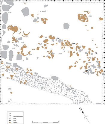
In Trench E, the lower of the two trenches, pre-Uruk levels were reached at a depth of approximately one metre below the surface. A wall foundation of unworked stones was uncovered, forming a corner in the northwest section of trench, parallel to which ran a half-metre-wide band of pebbles extending towards the southern section (Fig. 11). The pebble surface had a raised profile, rendering it unsuitable as a drain, and may represent the remnants of a dissolved mud wall or, conceivably, a narrow pathway. To the north and east of this feature, running along the same axis, was a large linear distribution of medium-to-large sized ceramic sherds of the Late Ubaid, or less likely the Late Chalcolithic period (see detailed discussion below). Owing to their common alignment it seems likely that the pottery and pebble feature originally lay on either side of a mud wall that was not visible during excavation. The pottery scatter appears to have consisted mainly of whole vessels crushed in situ, and therefore used and deposited contemporaneously (Fig. 12). Removal of the pebble surface and associated walls at the end of the season revealed a lower layer of occupational debris yielding Late Ubaid style painted pottery and a single fragment of Dalma impressed ware. The latter offers our first clear ceramic evidence for cultural interaction between the Shahrizor and the contemporaneous societies of the western Zagros highlands (cf. Henrickson Reference Henrickson, Henrickson and Thuesen1989; and further discussion, below).
Gurga Chiya, Trench E: Late Ubaid architecture and associated pottery scatter

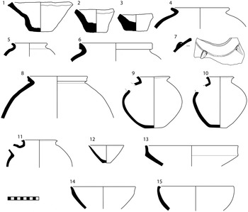
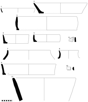
Late Ubaid/Late Chalcolithic vessels from the pottery scatter in Trench E at Gurga Chiya. 1, 8, 12, 15, 20, 22: brown coarse chaff-tempered. 7, 9, 13, 14, 17, 18, 19, 21, 24: green coarse chaff tempered. 2, 3, 10, 25, 26, 27: green medium chaff-tempered. 4, 16: buff coarse chaff tempered with white inclusions. 5: brown burnished medium chaff tempered with quartz inclusions, lumpy surface. 6: green burnished with quartz inclusions, lumpy surface. 11, 23: brown burnished medium chaff tempered

Parallels for the ceramics in the linear scatter and the deposit directly below can be found in both Late Ubaid and Late Chalcolithic assemblages elsewhere. The relevant pottery from Gurga Chiya was made mainly of medium and coarse chaff-tempered fabrics, ranging from pale reddish brown to buff and greenish in colour (Fig. 12: 1–3, 7–10, 12–15, 17–22, 24–27). Also present is a range of burnished fabrics, usually brown with a grey core but sometimes greenish, with variable amounts of chaff temper, quartz inclusions and white flecks (Fig. 12: 4–6, 11, 16, 23). Wide variation in fabric colour and inclusions, along with the limited range of forms and sometimes careless execution, points towards a relatively unstandardised ceramic industry, in which utility took priority over aesthetic considerations.
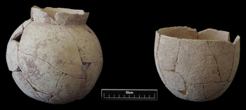
The assemblage includes a significant proportion of “angle-neck jars” (Fig. 12: 1–7; Fig. 13: left). According to Rothman these appear early in the LC2, for example at Hammam VA (Rothman Reference Rothman and Postgate2002a: 56, fig. 5: p, q, r; Akkermans Reference Akkermans and van Loon1988b, pl. 101: 48–51) and the Gurga Chiya examples have good LC2–3 parallels at Grai Resh (Kepinski Reference Kepinski2011, pl. 9.7–16, Pl. 10.1–7). However, they are already common in the Late Ubaid and LC1 periods, for example at Kenan Tepe in the Upper Tigris region, at Tell Madhhur in the Hamrin, at Hammam et-Turkman IVA–D in the Balikh, and at Tell Brak in the Khabur (Parker and Foster Reference Parker, Foster, Sağlatimur, Derin and Abay2009, fig. 4; Moon and Roaf Reference Moon and Roaf1984, fig. 18; Akkermans Reference Akkermans and van Loon1988a, pl. 75: 96–97, pl. 85.202, pl. 95.294, pl. 96.297; Oates Reference Oates and Marro2012, fig. 7: 3–4). An almost complete, thin-walled, undecorated example (Fig. 13, left), is similar to the finer angle-neck jars found in the Late Ubaid levels at Madhhur, as well as LC1 and LC2 contexts at Gawra XII and Hamoukar (Moon and Roaf Reference Moon and Roaf1984, fig. 18: 3; Tobler Reference Tobler1950, pl. 137: 293; pl. 138: 303; Abu Jayyab Reference Abu Jayyab and Marro2012, fig. 5: 6).
Left: Reconstructed “angle-neck” jar. Right: beaker, both of green medium chaff-tempered ware, from Late Ubaid levels at Gurga Chiya (cf. Figs. 13: 3, 13: 10; photograph by G. Brereton)

Some of the jars from Gurga Chiya are comb-incised (Fig. 12: 1–2). These do not resemble the comb-impressed wares assigned by Rothman to the LC2, but compare more closely to Late Ubaid pottery from Tepe Gawra (“below XII”, therefore likely Gawra XIIA), Khanijdal East, and particularly Tell Madhhur (Tobler Reference Tobler1950, pl. 138: 302; Wilkinson et al. Reference Wilkinson, Monahan and Tucker1996, fig. 10: 57; Moon and Roaf Reference Moon and Roaf1984, fig. 20: 4–8, 12–13). A body sherd with an incised herringbone pattern also has parallels at the latter site (Moon and Roaf Reference Moon and Roaf1984, fig. 20: 7, 13). The majority of angle-neck jars are in heavy brown or greenish burnished fabrics (Fig. 12: 4–6). The base of an unusually large “chalice” (a shallow dish with an extended hollow conical base, “stands or braziers” in Rothman's terminology) was found in the main pot scatter of GC-E (Fig. 12: 8). Again, similar vessels are known from both Late Ubaid and LC1–3 contexts across north Iraq and north Syria (Moon and Roaf Reference Moon and Roaf1984, fig. 21: 16; Rothman Reference Rothman and Postgate2002a, fig. 4: r, s; fig. 9: k; Kepinski Reference Kepinski2011, pl. 3: 7–14, Pl. 15: 18; Tobler Reference Tobler1950, pl. 135: 270–71, pl. 146: 399–401). A range of open forms (bowls or beakers) was also found. The most complete example, a medium-sized unpainted beaker (Fig. 12: 10; Fig. 13: right), can be compared to a plain Late Ubaid example from Gawra, “below XIII” (Tobler Reference Tobler1950, pl. 127: 171) and more precisely to plain Late Ubaid (i.e. Ubaid 4) beakers from Madhhur (Moon and Roaf Reference Moon and Roaf1984, fig. 16: 16–17, 20–21). Other more open forms (Fig. 12: 12–13) may relate to the Coba bowl tradition of flint-scraped vessels, considered hallmarks of standardisation and craft specialisation throughout the wider Near East in the pre-Uruk period (Marro Reference Marro and Marro2012; Baldi Reference Baldi and Marro2012). Deep open vessels with flat topped-rims were also identified (Fig. 12: 14–16), while a high proportion exhibit horizontally extended rims (Fig. 12: 17–19), with both Late Ubaid and LC2–3 parallels at Madhhur and Grai Resh respectively (Moon and Roaf Reference Moon and Roaf1984, fig. 17: 6–7; Kepinski Reference Kepinski2011, pl. 7: 1–2). Also common at Gurga Chiya were large open trays in a coarse vegetal tempered fabric ware (Fig. 12: 20–22). These do not appear to be widely characteristic of either the Late Ubaid or LC traditions in northern Mesopotamia. Similar, but considerably later, examples are known from Godin Tepe (Levels VI–VII), in the Kangavar Valley to the east (Rothman and Badler Reference Rothman, Badler, Gopnick, H. and Rothman2011, fig. 4: 52, Type Va). At Gurga Chiya these trays share their form and fabric with much earlier Late Neolithic (Halaf) pottery from the adjacent site of Tepe Marani (see below, and Fig. 19: 3–5, 9), perhaps pointing towards an element of long-term continuity in prehistoric traditions of cooking and cuisine along the western Zagros and adjacent foothill regions.
Painted pottery with simple geometric motifs was also recovered from the extended sherd deposit in Trench E, including two open-mouthed black-painted vessels, both with horizontal grids of filled and open rectangles (Fig. 12: 26–27). These are broadly comparable to decorated Late Ubaid sherds from Khanijdal East and Tepe Gawra XIII and “below XII” (i.e. Gawra XIIA; Wilkinson et al. Reference Wilkinson, Monahan and Tucker1996, fig. 12: 6, 9; Tobler Reference Tobler1950, pl. 127: 173, pl. 136: 278). Subject to further excavation and absolute dating, comparisons suggest a date close to the Late Ubaid-Late Chalcolithic transition (as described by Rothman Reference Rothman and Postgate2002a; and at least partly overlapping with the Lower 3 segment of the Nineveh Deep Sounding sequence; Gut Reference Gut1995: 92–95, 222–49). The relatively high percentage of painted pottery for this phase at Gurga Chiya (6.1 per cent by rim sherd count, 8.0 per cent by rim percentage) suggests that it is better described as Late Ubaid rather than LC1 or later (cf. Akkermans Reference Akkermans and van Loon1988a: 198, Table 31; Akkermans Reference Akkermans and van Loon1988b: 301, Table 50). This is supported by Late Ubaid parallels for the decorated vessels given above, both incised and painted. Furthermore, certain absences from the assemblage point towards a Late Ubaid attribution. For example Sprig Ware, characteristic of LC1 and LC2, is absent (cf. Rothman Reference Rothman and Postgate2002a: Table 2). Double and multiple-mouthed jars, elsewhere characteristic of LC 1–3, are also currently missing, as are the “casseroles” typical of LC 2–3 (cf. Kepinski Reference Kepinski2011, pl. 5: 1–5). “Double-rim jars” (cf. Rothman Reference Rothman and Postgate2002a, fig. 6: d–f) and stamped rosette decoration—both associated with LC 2—are likewise absent.
The Late Neolithic Period at Tepe Marani
The presence of Late Neolithic settlement remains on the neighbouring mound of Tepe Marani, first noted during the pilot season of 2012, was confirmed by the excavation of two trenches in the central part of the site. Building foundations were located in TM-A and a series of midden deposits in the smaller exposure of TM-B (Fig. 3), yielding associated radiocarbon dates of the mid-late sixth millennium b.c. These were calibrated at 2-sigma to 5620–5480 cal. b.c. (Beta-368798, 6600 ± 40 b.p.) for the architectural remains in TM-A, and 5320–5210 cal. b.c. and 5480–5230 cal. b.c. for the trash deposits of TM-B (Beta-368802, 6290 ± 30 b.p., and Beta-368801, 6370 ± 40 b.p.), placing the prehistoric settlement at Tepe Marani broadly within the Late Halaf or “Halaf-Ubaid transition phase” (cf. Campbell Reference Campbell2007).
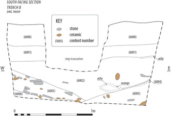
The TM-B middens were formed by trash deposits sloping steeply downwards to an exposed depth of c. 1 metre (Fig. 14), reflecting multiple episodes of digging, dumping and burning, the latter indicated by thick lenses of ash containing fragments of charred bone and organic matter, as well as ground and chipped stone tools. The trash deposits rested on and were cut into a dense layer of stones and ceramic sherds, including a number of re-joinable pieces and pieces with mending holes. The majority of sherds were spread evenly across adjacent dumping levels, horizontally bedded to create a continuous surface of unclear function.
Tepe Marani Trench B, northern section showing tip lines and overlapping trash deposits

The upper stratum of TM-A, which lies close to the summit of Tepe Marani, was formed of calcic xeresol. This soil type, common throughout northern Iraq, has been described as “self mulching”, such that features constructed of mud-brick or pisé are often transformed into a soil profile of natural appearance, leading to the disappearance of distinct strata, cut features, and structures. With sites over seven thousand years old, the upper habitation layers can become entirely homogenised by soil-forming processes, resulting in a matrix that contains only resistant artefacts such as pot sherds, worked stone, and large fragments of bone (Wilkinson and Tucker Reference Wilkinson and Tucker1995: 5). This appears to be the case at Tepe Marani.
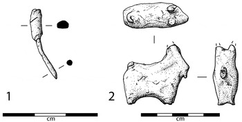
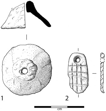
Among the finds and features observed “floating” in upper soil matrix of TM-A were concentrations of coarse pottery, bone, and chipped stone that may originally have been deposited within cut features, or on surfaces that are no longer visible. Notable small finds from these upper levels included a spindle whorl (Fig. 15: 1) and a steatite pendant with cross-hatched design (Fig. 15: 2), of a type widely documented throughout the Halaf culture area of northern Mesopotamia, and often interpreted as an early form of stamp seal for marking vessel closures (von Wickede Reference von Wickede1990).
1: Spindle whorl. 2: engraved stone pendant of Late Neolithic date from Tepe Marani, Trench A (drawn by N. B. Knudsen)

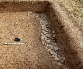
At a depth of c. 40 centimetres, a single course of rough-cut stones (c. 20–30 centimetres in diameter) was encountered, curving away from the east face of the trench (Fig. 16). Running east, and level with the base of this foundation wall, was a compressed deposit of ceramic, stone, and organic remains embedded within an ashy soil matrix, and including numerous burnt pieces. It would appear to represent destruction and collapse from a curvilinear structure, the layout of which remains to be established.
Late Neolithic curvilinear structure in Trench A, Tepe Marani

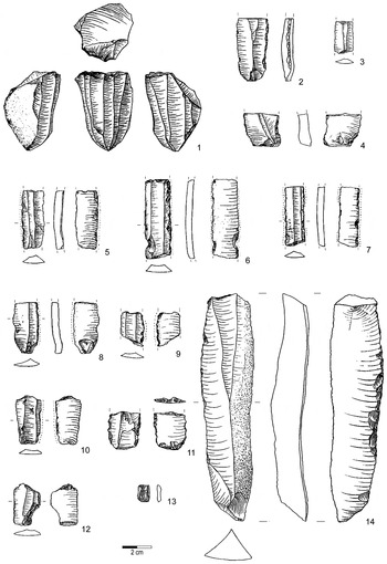
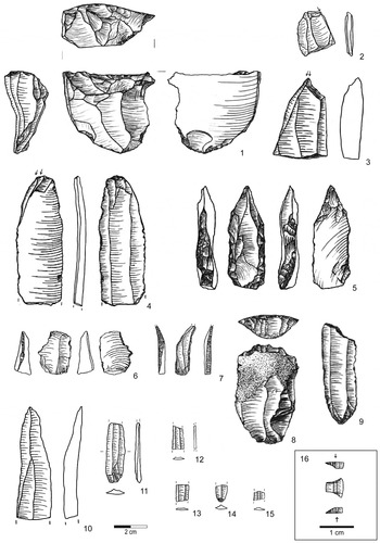
Chipped stone artefacts recovered from Trenches A and B (Fig. 17) are made almost exclusively on chert of beige-grey or brownish red colour, with a range of green, pink, and yellow hues. Artefacts from obsidian account for only 1.5 per cent of the total number, substantially lower than at the majority of Halaf sites (Healey Reference Healey2000: appendix 5). The assemblage is blade-oriented and broadly comparable to the Late Neolithic lithic industries of Tell Sabi Abyad (Copeland Reference Copeland and Akkermans1989), Yarim Tepe II (Merpert and Munchaev Reference Merpert, Munchaev, Yoffee and Clark1993) and Arpachiyah (Mallowan and Rose Reference Mallowan and Rose1935). However, chert assemblages from other Halaf sites such as Umm Qseir (Maeda Reference Maeda, Tsuneki and Miyake1998) and also Banahilk, on the nearby Rawanduz Plain (Watson Reference Watson, Braidwood, Braidwood, Howe, Reed and Watson1983: 572), were largely flake-based, indicating considerable variety in production and use of chipped stone across the wider region.
Chipped stone artefacts of the Late Neolithic period from Tepe Marani (drawn by H. Sosnowska)

Only one core has so far been found on Tepe Marani (Fig. 17: 1), but some knapping activities clearly took place on-site as indicated by the high proportion of dorsal side cortex on 12 per cent of the assemblage. Blades were sometimes intentionally broken into shorter segments, and the vast majority show unidirectional scar patterning on the dorsal side. Other modified pieces include borers (Fig. 17: 5, 6), drills (Fig. 17: 7), burins (Fig. 17: 2–4), retouched blades and flakes, end-scrapers (Fig. 17: 8), and notched tools. Silica gloss was noted on a small number of blades and on one retouched blade. Among the more unusual lithic finds was an obsidian microlithic trapeze (Fig. 17: 16). Tepe Marani also produced a significant assemblage of ground stone artefacts, including beads and grinding tools, which await study.
Further observations on the Late Neolithic ceramics from Tepe Marani
The two small trenches on Tepe Marani produced some 3880 sherds, many of which are highly decorated. The majority can be associated with the abandonment of the curvilinear structure in TM-A, and with the “pot pavement” of TM-B, forming a consistent Late Neolithic assemblage (although note the slightly later radiocarbon determinations for the latter context).
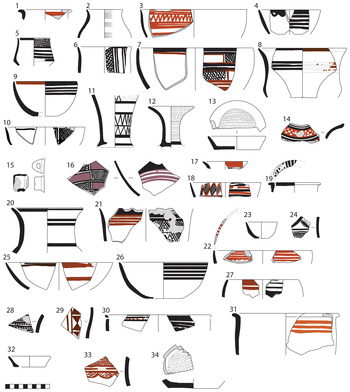
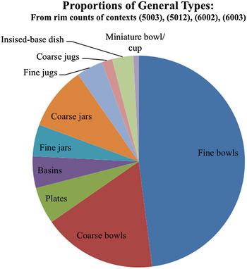
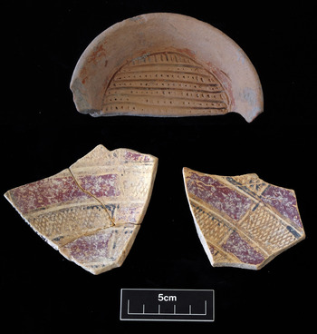
Pottery from Tepe Marani is entirely handmade, either by moulding in a basket or slab construction. Coarse and fine wares were readily distinguished, with ornamentation confined almost exclusively to the latter. The majority of vessels are fine ware bowls (Fig. 18: 1–30), followed numerically by thicker coarse ware bowls (Fig. 19: 11). Fragments of large storage jars (Fig. 19: 7–8) and shallow basins (Fig. 20: 2–5, 9) were also common. Certain vessel types may be distinctive to the Shahrizor Plain: notably a range of painted fine, medium and coarse ware dishes with deep incisions forming a grid across the interior base (Fig. 18: 13, 34; Fig. 19: 6; Fig. 20: top). Incised-base dishes of the same distinctive type were found at nearby Tell Begum, north of the Darband-i Khan Lake (Hijjara Reference Hijjara1997, pl. 87:1).
Late Neolithic fine and medium wares from Tepe Marani. Illustrated paint colours are broadly indicative only, ranging from black to grey to brownish black (indicated in black), and from red to orange to red-brown to maroon (indicated in various shades of red). Faint traces of paint are indicated as hatched. 1–16: Fine ware with limy white inclusions and speckling. 17–30: Fine ware with no visible inclusions. 31–34: Medium ware with medium to fine chaff, limy white inclusions and speckling. Nos. 13 and 34 are incised

Painted decoration on fine wares at Tepe Marani includes monochrome, bichrome, and polychrome designs (Fig. 18). The most common combination is black and red, although red-orange, maroon, purple and white pigment was also used. Geometric designs include crosshatched and checked patterns common to Halaf assemblages at chronologically earlier sites, such as Arpachiyah in Nineveh Province (Mallowan and Rose Reference Mallowan and Rose1935) and contemporaneous levels at Domuztepe in southern Turkey (Campbell et al. Reference Campbell, Carter, Healey, Anderson, Kennedy and Whitcher1999; Spataro and Fletcher Reference Spataro and Fletcher2010). Closer to hand, comparisons can be drawn with Halaf pottery assemblages from Tell Hassan (in the Jebel Hamrin region; Fiorina and Bulgarelli Reference Fiorina and Bulgarelli1985), from Kudish Saghir (near Kirkuk; Starr Reference Starr1937–39), Banahilk (in the Rawanduz Plain), and above all from nearby Tell Begum (Nieuwenhuyse et al. Reference Nieuwenhuyse, Odaka, Kaneda, Mühl, Rasheed and Altaweel2016). However, certain decorative elements typical of Halaf pottery elsewhere—including figural motifs depicting horned animals and flora—have not yet been documented at Tepe Marani.
Overall the Tepe Marani ceramic assemblage exhibits striking variation in vessel form (even within particular classes of vessel, for which see Chart 1), and also in the execution of decorative designs. Such pronounced variation at the level of individual vessels suggests that precise replication of finished ceramic products was consciously avoided by potters, even as general principles of manufacture and ornamentation became widely disseminated between small-scale communities across the northern part of the Fertile Crescent, including Iraqi Kurdistan. Avoidance of exact copying within a shared technological milieu is typical of Late Neolithic pottery assemblages across this much wider region—most notably in fine, ornamented wares—and can be regarded as a defining feature of the Halaf cultural expansion, giving way gradually to more standardised modes of ceramic production and reduced ornamentation during the Ubaid and Uruk periods (cf. Wengrow Reference Wengrow1998; Reference Wengrow2001). These broader cultural trends are clearly replicated within the late prehistoric assemblages at Tepe Marani and Gurga Chiya, and more widely within the Shahrizor.
Proportions of main Late Neolithic vessel types at Tepe Marani (by H. Himmelman)

Environmental archaeology (see also Appendices 1 and 2)
Botanical assemblages: Tepe Marani
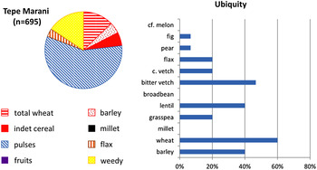
From the initial season at Tepe Marani, fourteen flotation samples were studied from approximately 280 litres of sediment. These produced 695 seeds and seed fragments. The vast majority come from midden deposits in Trench B. They appear consistent with the disposal of hearth cleanings, which incorporated waste from cereal de-husking and cooking accidents. The Tepe Marani assemblage is dominated by pulses (57.7 per cent) followed by cereals (23.2 per cent), with 2.6 per cent flax and 15.7 per cent various wild seeds probable attributable to arable weeds (Chart 2).
Proportions of plant categories in the overall Tepe Marani assemblage, and the ubiquity (% of sample in which present) for selected taxa (bar chart to right; by D. Fuller)

Despite the large numbers of pulses, wheat has the highest ubiquity, being present in 60 per cent of samples. Of note are the single finds of a pear (Pyrus sp.) and a fig seed (Ficus sp.). Wheat is predominantly emmer (Triticum cf. dicoccum), represented by 10 grains and 50 glume-bases. A few grains of probable two-grained einkorn (Triticum cf.) are present. Barley included symmetrical and asymmetrical grains, suggesting a six-row form, primarily hulled (Hordeum vulgare L.). The pronounced dominance of wheat over barley is characteristic of other Late Neolithic archaeobotanical assemblages including Ras Shamra IV, Domuztepe, Umm Qseir, Tell Aqab (Kansa et al. Reference Kansa, Kennedy, Campbell and Carter2009; McCorriston Reference McCorriston1992; Van Zeist Reference Van Zeist and Bakker-Heeres1984). Large quantities of lentils with fewer bitter vetch are found at these other sites.
Of particular note is the high level of flax (Linum ussitatissimum) at Tepe Marani. Although very few seeds have been noted at the sites of Ras Shamra and Domuztepe this is in relation to 1000s of cereal remains, while the appearance of 2.6 per cent flax in the present, smaller assemblage is significant, given that an oily seed of this type has strong preservation bias against it. Flax was likely a multipurpose crop, having been grown as an edible oilseed (high in omega-3 fatty acids) as well as for its stem's fibres. While genetic data indicates that oilseed or unspecialised varieties are primitive, with specially adapted high fibre-producing varieties being a later development, it is clear from textile finds in the Pre-Pottery Neolithic (e.g. at Çatalhöyük, in central Turkey) that textile production was established quite early. Given the additional presence of spindle whorls (Fig. 15: 1), it seems likely that textiles were among the Late Neolithic craft products at Tepe Marani.
Botanical assemblages: Gurga Chiya
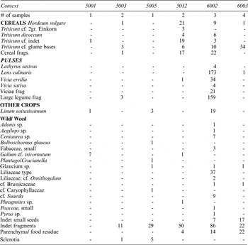
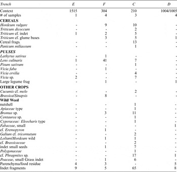
The quantity of archaeobotanical information from Gurga Chiya is so far smaller than at Tepe Marani. This can be partly attributed to the shallowness of the initial trench samples in 2013. The Late/Terminal Ubaid phase is represented by a single assemblage, from Trench E, which confirms the presence of wheat and lentil. The fourth millennium b.c. is represented by samples from Trench F, notably from within the soil matrix of a large accumulation of Middle Uruk pottery. Its contents include crops, a small amount of wheat chaff, and an assortment of wild seeds most probably deriving from weeds (28 per cent). This sample is dominated by lentils (Lens culinaris) (30 per cent) but includes barley (Hordeum vulgare L.) (6.5 per cent) and wheat, including probable one-grained einkorn (Triticum monococcum). A single specimen of broad bean (cf. Vicia faba) was found. Of interest are a small number of possible mustard seeds (Brassica/Sinapsis sp.), which warrant further examination.
Late Bronze Age agriculture at Gurga Chiya is represented by an assemblage from Trench C, which represents the charred contents of an oven dated to the fourteenth or early thirteenth centuries cal. b.c. (see above). About half the sample consists of various seeds of wild/weedy taxa, and crops (wheat and barley) account for around 28 per cent, split evenly between barley and wheat. The barley may be mainly two-row hulled, while the wheat where identifiable is emmer. Pulses (17.5 per cent) are dominated by lentil and bitter vetch, with a single specimen of probable pea (cf. Pisum sativum).
Of particular interest is the presence of a well-preserved grain of millet (Panicum miliaceum) in the thirteenth/fourteenth century b.c. sample, and two seeds most probably of melon (cf. Cucumis melo). Melon may have been established in the Bronze Age Indus Valley, and still earlier in predynastic Egypt (Fahmy et al. Reference Fahmy, Friedman, Fadl, Fahmy, Kahlheber and D'Andrea2011); but finds in Mesopotamia have been rare (Zohary et al. Reference Zohary, Hopf and Weiss2012). Millet is of particular interest as this species originated in China and its early dispersal westwards into Europe and the Near East has been controversial. Despite claims for Neolithic finds in Europe, critical reviews suggest an initial arrival after 3000 b.c., with reliable direct AMS dates only from c. 1500 b.c. (e.g. Boivin et al. Reference Boivin, Fuller and Crowther2012; Motuzaite-Matuzeviciute et al. Reference Motuzaite-Matuzeviciute, Staff, Hunt, Liu and Jones2013; Valamoti Reference Valamoti2013). In Mesopotamia, finds at Nimrud may be early Iron Age, while those from Haftavan in northwest Iran date between 1700–1300 b.c. (Miller Reference Miller, Van Zeist, Wasylikowa and Behre1991; Zohary et al. Reference Zohary, Hopf and Weiss2012). The isolated find from Gurga Chiya may therefore relate to the initial spread of this summer season crop into the Mesopotamian lowlands.
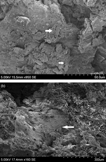
Charred food remains Twenty-five flotation samples from Tepe Marani and eleven from Gurga Chiya were scanned for charred food remains represented by amorphous charred organic lumps. The occurrence of this type of material is very high, with food fragments recovered from more than 60 per cent of the flotation samples at both sites. These remains were initially examined under low-powered binocular microscope (0.8 to 4.0 magnification) to identify preliminary plant cell structures, which were then further analysed using Scanning Electronic Microscopy. Epidermal fragments, most likely from wheat (Triticum cf.), were identified within Late Neolithic (5480–5230 cal. b.c.) fragments of processed grain from Trench B at Tepe Marani (Fig. 21: a). Additionally, Late Bronze Age (1390–1120 cal. b.c.) charred fragments of food were recovered from Trench C at Gurga Chiya (Fig. 21: b). Very clear epidermal cell structures of wheat, Triticum cf. and barley, Hordeum vulgare (ind. var) have been identified within the Gurga Chiya food remains, suggesting the mixing of different cereal ingredients in the preparation of Bronze Age meals.
Late Neolithic coarse wares from Tepe Marani. 1–6: brown coarse ware with coarse chaff temper and variable quantity of white inclusions. 7–11: buff coarse ware with coarse chaff temper and frequent white inclusions

Examples of base-incised and polychrome painted wares from Tepe Marani (photograph by G. Brereton)

SEM images: a. Late Neolithic fragments of processed grain from Trench B at Tepe Marani; b. Late Bronze Age charred fragments of food from Trench C at Gurga Chiya

A note on animal bone assemblages (by Elizabeth Farebrother)
The first series of excavations at Gurga Ciya and Tepe Marani yielded a significant assemblage of animal bones fragments, which are currently undergoing zoo-archaeological analysis. It is already clear that cattle, caprines (sheep and goat) and pig are the most commonly represented fauna at both sites. More precise identifications of species and the proportion of wild to domestic taxa will be clarified in a future report. Evidence of carnivore gnawing and burning is visible within both assemblages, and butchery marks were observed on the faunal remains from Gurga Chiya. Molluscs and micro-faunal remains were recovered from both sites. Adult and sub-adult animal mandibles—mainly from cattle, caprines, and pig—were recovered from Gurga Chiya. At present much of the dental material from Tepe Marani is represented by individual teeth. Dental ageing studies, plus epiphyseal fusion analysis, are planned in order to investigate changing methods of animal management in the later prehistory of the Shahrizor.
Summary, preliminary interpretations, and conclusion
The main achievement of the excavations at Tepe Marani and Gurga Chiya so far has been to document prehistoric human settlement of the southern Shahrizor, spanning a period of more than two millennia, between c. 5600 and 3300 b.c. The results demonstrate beyond doubt that the “hilly flanks” of the Zagros—long famous for their Palaeolithic, Epipalaeolithic and Early Neolithic sites—were also fully integrated into later prehistoric developments affecting the wider Middle East.
Of particular interest is the discovery of a Middle Uruk assemblage in the Late Chalcolithic 3–4 levels at Gurga Chiya. While not associated with preserved architecture, the presence of a representative suite of southern Mesopotamian-style pottery at this location, together with associated radiocarbon dates, adds to an emerging picture of cross-regional interaction along the northern tributaries of the Tigris during the fourth millennium b.c. This emerging picture has implications for any wider understanding of the “Uruk expansion”, arguably the earliest large-scale commercial and colonial expansion in world history, with its epicentre on the southern Mesopotamian alluvium (Algaze Reference Algaze2008; Wengrow Reference Wengrow2010: 66–87).
In his original analysis of that process, Guillermo Algaze (Reference Algaze1993: 63–72) envisaged an intensification of cultural contact and exchange between urban centres of the Mesopotamian floodplain and riverine populations inhabiting the main routes between the Tigris piedmont and the central Zagros. Such a process would mirror developments far to the west along the Middle-Upper Euphrates and the Taurus foothills, where the Uruk expansion is documented through detailed archaeological surveys and excavations. Algaze suggested that the penetration of Uruk-related assemblages and manufactured products into these distant areas reflects a predatory expansion of lowland Mesopotamian commercial interests, providing densely populated cities on the alluvium with access to upland resources such as metals, timber, and minerals.
The application of Algaze's model to the lands east of the Tigris was initially based on slim but suggestive evidence from sites such as Qalinj Agha (in the suburbs of Erbil), Nuzi (Yorghan Tepe), and indeed Bakr Awa, where small quantities of Uruk-style pottery and occasionally architecture were documented in brief preliminary reports. Subsequent excavations at Bakr Awa, discussed earlier, substantiate his thesis, as does new fieldwork at the much smaller (c. 1 hectare) site of Kani Shaie, overlooking a key overland pass through the Bazian Mountains and the Shahrizor Plain (Renette, Reference Renette, Kopanias and MacGinnisforthcoming). As at Gurga Chiya, the Uruk assemblage at Kani Shaie has been dated to the LC 4 phase, around the middle of the fourth millennium b.c. In combination, the new evidence from these two sites demonstrates an expansion of southern Mesopotamian contacts along the principal left bank tributaries of the Tigris, perhaps some centuries prior to the consolidation of (Late) Uruk contacts along the Khorasan Road to the south, as attested at Godin Tepe VI:1 (for which, see Gopnick and Rothman eds. Reference Gopnick and Rothman2011).
The establishment and intensification of contacts between lowland Mesopotamia and the central Zagros region in the fourth millennium b.c. was a complex process, reflecting—not just long-range flows of people and resources—but also cultural choices taking place at a local scale, including the exchange of specialised knowledge concerning seasonally variable routes and resources (Rothman Reference Rothman and Petrie2013; Wilkinson Reference Wilkinson.2014). A diversity of responses to the possibilities of long-distance trade is already evident in the western Zagros and adjoining lowlands in the preceding (Ubaid) period. Among earlier studies, petrographic analysis of ceramics by Elizabeth Henrickson (1989) was especially significant in revealing divergent patterns of cultural interaction between villages of the Ubaid tradition and the central Zagros highlands.
Settlements in the Jebel Hamrin region, such as those at Tell Abada (Jasim Reference Jasim1985) and Tell Madhhur (Roaf Reference Roaf, Henrickson and Thuesen1989)—both with close ceramic parallels in the lower levels at Gurga Chiya—were already linked through exchange to the Mahidasht and Kangavar Valleys (segments of the Khorasan Road) in the fifth millennium b.c. But the links are evident primarily in the mixing of local ceramic traditions, rather than the flow of metals and minerals obtained from further afield on the Iranian Plateau (Henrickson Reference Henrickson, Henrickson and Thuesen1989). The scarcity of such long-range imports at both Tell Abada and Tell Madhhur is intriguing, especially when contrasted with the emergent situation at Tepe Gawra (levels XIII–XIIA), on the Tigris piedmont to the north (Rothman Reference Rothman2002b). There, in the Late Ubaid period, interaction with the peoples of the Zagros had already produced a westward flow of materials such as lapis lazuli, copper, and obsidian, later accompanied by gold, carnelian, and no doubt also perishable goods such as upland fauna, flora, and fine timber (Rothman Reference Rothman and Rothman2001: 379).
Many of these imported materials would subsequently become key markers of value for lowland urban societies (Wengrow Reference Wengrow2010). However, their status as “luxuries” and “valuables” appears not to have been self-evident, and was most likely contested on a local scale, especially during the initial expansion of highland-lowland contacts in the sixth and fifth millennia b.c. In this respect the Shahrizor Plain can be seen to lie midway between two alternative paths of interaction between the Ubaid lowlands and the neighbouring Zagros—one route passing to the north, along the southern shores of Lake Urmia, and the other to the south, through the Mahidasht—which in turn seem to have been characterised by different sets of values and priorities.
On a wider scale the fifth millennium b.c. is characterised by the transfer of Ubaid material culture—including a characteristic range of craft products and house forms—over a truly enormous area, reaching at its maximum extent from the Arabian Gulf to the eastern corner of the Mediterranean, but with no obvious centre of gravity (Wengrow Reference Wengrow2010: 54–65). Understanding this process on a macro-regional scale has proved extremely difficult, and recent interpretation focuses increasingly on the diversity of local interactions—terrestrial and maritime—that underpin the apparent homogeneity of Ubaid material culture (see Carter and Philip eds. Reference Carter and Philip2010). Further investigation of the Ubaid levels at Gurga Chiya will add a significant dimension to our understanding of these localised patterns of interaction as played out on the eastern frontier of the Mesopotamian world, including their place in the wider Ubaid interaction sphere and their subsequent transformation in the Uruk period.
The Late Neolithic habitation at Tepe Marani, adjacent to Gurga Chiya, spans the mid–late sixth millennium b.c., and so far exhibits a variety of features consistent with Halaf-period sites in northern Mesopotamia, the Diyala Plain, and the Jebel Hamrin. They include a rich and diverse assemblage of hand-made and painted pottery, the use of stamp seals as personal amulets (and possibly also for the marking of sealed goods), and evidence for the processing of flax into yarn. Less typical at this point is an apparently low frequency of obsidian in the lithic assemblage, and the absence of figural ornamentation from pottery. Further comparison of botanical and faunal assemblages from Tepe Marani and Gurga Chiya has the potential to shed light on long-debated issues of cultural change in the later prehistory of the region such as the transition from flax to wool as a primary textile material (McCorriston Reference McCorriston1997), the beginnings of animal traction and the origin of dietary changes such as the inception of fermented cereal (bread and beer) and processed dairy products (cf. Sherratt Reference Sherratt1997; Evershed et al. Reference Evershed, Payne, Sherratt, Copley and Coolidge2008).
Such wider questions are best addressed in view of more local issues of interpretation. What, for example, prompted the relocation of human settlement from Tepe Marani to the nearby site of Gurga Chiya, sometime towards the close of the sixth millennium b.c.? To what extent can continuity and change be detected in the material culture, subsistence economies, and social organization of the people who inhabited these two sites? Why the long hiatus between Uruk and Late Bronze Age levels at Gurga Chiya, by contrast with the similarly proportioned site of Kanie Shaie to the west, where substantial third millennium occupation is evident? How do these localised shifts in habitation reflect the distinct ecology of the Shahrizor, with its atypical levels of precipitation? To what extent were they enabled or constrained by wider patterns of interaction between the Mesopotamian lowlands and the highlands of western Iran, as these shifted and expanded over a period of millennia? Answering such questions will require further fieldwork, and continued protection of the Shahrizor's rich archaeological landscape from the effects of intensive agriculture and mineral prospection.
Archaeobotanical data from Tepe Marani. Counts represent number of identifiable specimens. Each sample was approximately 20L original sediment volume.

Archaeobotanical data from Gurga Chiya. Counts represent number of identifiable specimens. Each sample was approximately 20L original sediment volume.