1. Introduction
Nowadays, the discovery of new worlds (planets) is announced in advance and widely disseminated, as seen in the endeavour to reach Mars, a mission expected to take up to one year. This scenario of a voyage lasting several months is reminiscent of the age of exploration in the 15th, 16th and 17th centuries (Morison, Reference Morison1993), ushered in by the Portuguese in 1415 with the taking of Ceuta in North Africa, and culminating in the discovery of Oceania in 1770 by Captain James Cook. Unlike today, these maritime expeditions were kept secret, since there was practically no scientific or technological difference between the countries interested in exploring new lands. In the 15th century, none of the so-called natural sciences existed; it was a time of obscurity and little technological knowledge (Rossi, Reference Rossi2001). Thus, maritime routes and the construction of Caravels and Naus (vessels) were closely guarded secrets. Political and religious support was essential for major decisions, and without the king’s or church’s backing, success in any undertaking was nearly impossible. For example, Christopher Columbus’s journey is estimated to have cost the equivalent of 3,000 gold coins, amounting to 60 kg of gold (Geraldini, Reference Geraldini1520; Boxer, Reference Boxer1969), valued at 3.6 million dollars using today’s price (60 dollars per gram), much lower than the 100 million dollars per year announced by NASA for a trip to Mars (NASA, 2023).
Due to Portugal’s geographical location at the southwestern tip of Europe, the only economic and political outlet was through the ocean. Mastering shipbuilding, understanding maritime routes and controlling shipping lanes were the first steps in this long journey. Wind direction was a crucial factor in the first global expansion. Understanding ocean winds is as important as the desire to expand Christianity or the determination of royalty to acquire more lands and wealth. It is primarily the difference in temperature (pressure) between the equator and the poles that causes winds to travel from the warmer (higher pressure) to the colder (lower pressure) regions. This is known as the first law of atmospheric circulation in meteorology (Encyclopedia Britannica, 2023). Due to the Earth’s spherical shape and daily rotation, the Coriolis force determines the circuit of winds and ocean currents between the equator and the poles. In the Northern and Southern Hemisphere, they rotate clockwise and counterclockwise, respectively (Coriolis, Reference Coriolis1835; Chesman et al., Reference Chesman, Cavalcanti-Neto and Furtado2023). This circulation using the Coriolis force was explained by the end of the 19th century (Moore, Reference Moore, North, Pyle and Zhang2015). Discovering these routes created by the Coriolis force was one of the tasks of the great navigators during the European maritime expansion in the Age of Exploration.
Chesman et al. (Reference Chesman, Cavalcanti-Neto and Furtado2023) provide a description with many didactic illustrations of how the Coriolis force was crucial in navigations between the North and South Atlantic Ocean. It particularly describes the true route to reach the Cape of Good Hope. The route necessarily hugs the east coast of Brazil and not the west coast of Africa, according to the journey of the Portuguese explorer Bartolomeu Dias, to reach the southernmost point of Africa. Curiously, this route resembles the mathematical symbol for infinity or the analemma, as shown in Figure 9 of Chesman et al. (Reference Chesman, Cavalcanti-Neto and Furtado2023).
In the early 15th century, Portuguese maritime expansion followed the west coast of Africa, seeking new lands, more wealth and the domination of new peoples. However, spices still arrived overland in Europe from the Genoese and Venetians until the fall of Constantinople in 1453. Thus, trade with the East was affected, with an increase in fees and prices for spices from India and Arabia. Additionally, the Catholic Church aimed to expand Christianity in new lands, with Africa under domination and the East waiting to be discovered through a new maritime route, bypassing Africa. King Dom João II (1455–1495) financed several fleets to find a maritime route to India. In 1488, Bartolomeu Dias successfully circumvented the Cape of Good Hope, the southernmost point of Africa. This route around the Cape was kept secret by the Portuguese crown, at least until the signing of the Treaty of Tordesillas in 1494. Only then did the Portuguese manage to reach India, but in the following year, Dom João II died. Only in 1497 did the new king, Dom Manuel I, send a new maritime expedition to India, led by Vasco da Gama, a journey that began on July 8, 1497, and ended on May 18, 1498, covering over 20,000 km in a little over 10 months.
Due to the economic and political success of Vasco da Gama’s fleet, Dom Emanuel I organised the largest and most powerful Portuguese fleet of the time, consisting of 13 vessels (3 caravels and 10 naus) and approximately 1,500 men, commanded by the nobleman Pedro Alvares Cabral. On the way to India, the fleet found Brazil, and this was registered in Pero Vaz de Caminha’s letter [08], a report of the voyage of discovery of Brazil commissioned by Pedro Cabral to be sent to King Dom Emanuel I, notifying him of the possession of the new lands.
2. Pero Vaz’s letter
In addition to this letter, there are two other documents, known as records of the birth of Brazil: The Anonymous Pilot’s Report, published in 1507 (Hue, Reference Hue2021), and Master João Faras’s letter (Varnhagen, Reference Varnhagen1843). The Anonymous Pilot’s Letter was published in Italian by Fracanzano da Montalboddo (Montalboddo, Reference Montalboddo1507) who claimed to have translated it from a Portuguese document, although the original document has never been found. A significant scientific detail in this report is the record of a comet that appeared continuously in the sky for 8 or 10 nights at the end of May 1500. Master João Faras’s letter provides more scientific data, describing, for the first time, the Southern Cross constellation and, using a nautical astrolabe, determining the latitude of Pedro Cabral’s fleet’s landing site. However, these two documents are not official records from the Portuguese royal archives. Here, only Caminha’s letter will be analysed.
To present the scientific data, the document entitled ‘Pero Vaz de Caminha’s Letter’, will be used as reference in an edited and commemorative version for the 500th anniversary of Pedro Cabral’s arrival in Brazil in 2000 (Magalhães and Salvado, Reference Magalhães and Salvado2000). This document by Magalhães and Salvado (Reference Magalhães and Salvado2000) is in Portuguese, but there are several copies in other languages that can be easily found on the internet.
3. Data and scientific analysis of Pero Vaz’s letter
To organise and specify the scientific information in Pero Vaz’s letter, it will be explained following the page and paragraph number of the reference document (Magalhães and Salvado, Reference Magalhães and Salvado2000).
The key dates that represent temporal data provide the speeds of the vessels, which appear on the first pages of the letter. The fleet departed from Portugal on March 9, 1500, as written at the end of page 4 in a single paragraph. The passage through the Cape Verde islands was recorded on March 22, 1500, on page 5, paragraph 2. Here, the speed of the vessels can be calculated. A map can be used to measure the distance between the Port of Belém in Lisbon to Cape Verde, which is approximately 2,700 km, corresponding to an average speed of 8.7 km/h, calculated by dividing 2,700 km by 312 hours (13 days). Nearly one month later, on April 21, they observed signs of land at dusk, having travelled 660 or 670 leagues (6 km = 1 league), which corresponds to nearly 4,000 km (pages 4 and paragraph 5). Thus, the average speed for this journey was 5.6 km/h (4,000 km/720 h). Towards the end of the letter, on page 29, paragraph 3, the departure date is recorded as May 1, 1500, meaning they spent approximately 10 days anchored near the coast.
The next analysis can be conducted by investigating the 4,000 km between the Cape Verde islands and the land sighting location, considering the trajectory determined by wind and ocean currents, as presented in Figure 9 of Chesman et al. (Reference Chesman, Cavalcanti-Neto and Furtado2023), and this route is attributed to Vasco da Gama’s voyage in 1498 (Museu de Marinha de Portugal, Comissão Cultural da Marinha, 2021). Tracing this route on a Google Earth map, following the wind and ocean currents for 4,000 km, leads to the coast of Rio Grande do Norte state in Northeast Brazil. The route is illustrated by the yellow line in Figure 1. This is where the North and South Atlantic currents meet, coming from Africa, and in Brazil, they diverge. Thus, sailboats are guided from east to west by the trade winds.
Photograph of the Google Earth screen showing the yellow line as the route taken by Cabral’s fleet from the Cape Verde islands to the coast of Rio Grande do Norte, covering approximately 4,000 km. The yellow line follows the trajectory taken by Vasco da Gama and the direction of the wind and ocean currents created by the Coriolis force. Source: the authors (2023).

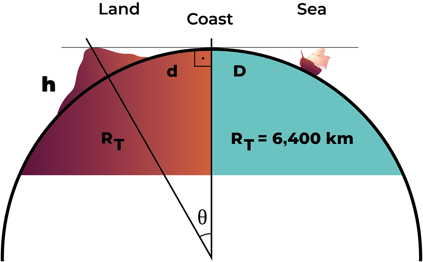
If this link of 4,000 km is used to reach Porto Seguro in Bahia state, the city established as the arrival point of Cabral’s fleet according to Varnhagen (Reference Varnhagen1843), the trajectory must be a straight line between Cape Verde and Porto Seguro, a route inconsistent with the wind and ocean current paths induced by the Coriolis force. After the fleet found signs of land, the first written anchoring information is the distance to the coast on April 23 (page 6, paragraph 6), recorded as 6 leagues from the coast (36 km). Given that the sighting distance was on the previous day at dusk, this should correspond to a slightly greater distance than 36 km. At this sighting distance, a ‘…large, very tall and round mountain, and other lower mountains to the south’ was observed (page 5, paragraph 5). At this sighting distance and considering the Earth’s shape, as shown in Figure 2, an estimate of the height (h) of the mountain seen from the sighting distance can be made. Using the definition of angle in radians (θ rad ) and the right-angled triangle formed by the hypotenuse with the Earth’s radius plus the height h of the mountain and adjacent side R T , see the drawing in Figure 2, according to the following equations:
 $${\theta _{rad}} = {\raise0.7ex\hbox{$D$} \!\mathord{\left/ {\vphantom {D {{R_T}}}}\right.}\!\lower0.7ex\hbox{${{R_T}}$}}$$
 $$\cos \left( {{\theta _{rad}}} \right) = {\rm{\;}}{\raise0.7ex\hbox{${{R_T}}$} \!\mathord{\left/ {\vphantom {{{R_T}} {\left( {{R_T} + h} \right)}}}\right.}\!\lower0.7ex\hbox{${\left( {{R_T} + h} \right)}$}}$$
Drawing of the ship’s view at distance D from the coast and a hill at distance d from the coast. In this figure, d is equal to D, under the condition that it tangentially intersects the line of sight of the hill with height h by the vessel. The drawing includes a right-angled triangle with hypotenuse RT + h, adjacent side RT, and angle θ. Source: the authors (2023).

Using the data D = d and d = 40 km, R T = 6,400 km, and substituting these values into Equations (1) and (2) provide the height of the hill, which should be 125 m. For 30 km, the height corresponds to 70 m. Thus, hills with heights between these values could be sighted from distances between 40 km and 30 km, respectively.
A view from the east to west along the northern coast of Rio Grande do Norte (RN) reveals a hill 55 km from the coast in the city of João Câmara, today called Torreão Hill, with an altitude of 240 m. With a view from the north to the south of the RN coast, a peak approximately 70 km away can be seen (Cabugi Peak), with an altitude of 590 m. It cannot be seen from an east to west view from the sea, since it is approximately 120 km from the coast, making it imperceptible, because at this distance, the altitude needed to be seen is 1,125 m and not the current 590 m. The hill named Monte Pascoal by Varnhagen (Reference Varnhagen1843), located in the south of Bahia, 15 km from the coast, with an altitude of 540 m, could be visible from 83 km according to Equations (1) and (2). Based on the information in Caminha’s letter, Torreão Hill appears to be the hill spotted by Cabral’s fleet, since the view is from east to west and the altitude corresponds to that determined by Equations (1) and (2) to be visible between 30 and 40 km from the coast.
In Figure 3, a photograph ‘land ho’ taken approximately 30 km from the coast shows Serra Verde Hill, here called Monte Pascoal Potiguar (MPPotiguar) at the geographical coordinates 5°25′20″S 35°50′20″W, with a view from east to west. The hill is clearly visible in the centre of the photograph, and there is also a bird on the right side. This geographical protrusion, shaped like a larger geographical hill, not a peak (Cabugi Peak and Monte Pascoal in Bahia have peak-shaped geographical features), and two lower ranges to the south (to the left of the larger hill) can be seen, exactly as described in the text on page 5, paragraph 5, are Torreão Hill and Amarelão Hill, respectively.
Photograph ‘land ho’ taken approximately 30 km from the coast, featuring the MPPotiguar in the centre of the image, currently known as Serra Verde Hill, with a view of the ocean from east to west. In this photograph, the smaller hills to the left of MPPotiguar can be seen and, to the far right, Torreão Hill and Amarelão Hill, a bird, a ‘Fura-bucho’ (Manx Shearwater), as described in Caminha’s letter describing the signs of land on page 5, paragraph 5. Source: the authors (2024).

After the first sailors disembarked at the mouth of a river, they decided to search for a place to anchor the entire fleet because the coast where they had anchored had many reefs. This location was found approximately 10 leagues (60 km) north of the mouth of the river (page 7, paragraph 3). It was here that they found the so-called safe harbour, ‘…they found a reef that contained a very good safe harbour, with a very wide entrance’ (page 7, paragraph 3). To reach this ‘safe harbour’, they travelled northward carried by the southeast winds (southwest in current pronunciation) (page 6, paragraph 4). On page 10, in the first paragraph, there are elements describing the dimensions of this port, ‘…the anchorage was so large and fine and safe that more than 200 ships and naus could lie in it’. Considering the size of the vessels (50 m by 20 m) and caravels (25 m by 10 m) at the time, this must correspond to an area of 200,000 m2 that could accommodate 200 ships; this should be the approximate area of this harbour. Maps of the north coast of RN show reefs with the above descriptions that represent this safe harbour corresponding to the geographical coordinates 5°04′27″S 35°47′40″W, today called Marco Beach, since it has a Portuguese marker, according to historians, planted on August 7, 1501, by Américo Vespúcio’s fleet (Thomas, Reference Thomas2003). However, in Caminha’s letter, on page 27, paragraph 3, it says ‘Planted the cross with Your Majesty’s arms and motto’. This was done on May 1, 1500 (page 26, paragraph 50). A ‘cross bearing Your Majesty’s arms and motto’ can also be interpreted as a finding marker, a possession marker, that is, one of the markers of the discovery of Brazil, since another similar marker was found on the RN coast, namely, the marker of Cananeia, a city south of São Paulo.
In the region of Marco Beach, there is a predominance of southeast winds, and the dimensions of this harbour are approximately 1,500 m (east-west) by 700 m (north-south). From the shore to the reefs, approximately 200 vessels can comfortably fit (in this area, approximately 1,000 vessels could fit). See Figure 4 for a satellite image of Marco Beach and the city of Porto Seguro, both at the same 1,000-m scale. From these images, one can infer the dimensions of each harbour. South of Porto Seguro is a river mouth approximately 350 m wide, with reefs along the coast for approximately 1,500 m. These dimensions are half as large when compared with the Marco Beach region. Moreover, this wide river (Buranhém River) is not mentioned in Caminha’s letter as being so large. Considering the dimensions, locations and the planted marker, Marco Beach Bay is more like the safe harbour described by Caminha.
Photographs of the Google Earth screen, with the same 1000-m scale for both bays, at Marco Beach (5°04′28″S 35°47′39″W) photo above and Porto Seguro (16°26′52″S 39°03′35″W) photo below. Source: the authors (2023).

To identify the river mouth of the first landing, measurements were taken on a 60 km map south of Marco Beach along the coast, reaching the Punaú River (5°20′55″S 35°21′27″W) at Zumbir Beach in the municipality of Rio do Fogo. This would be the river of the Cabral fleet’s first landing, and Zumbir Beach must have been the first beach visited by Cabral’s fleet. The last written distance on the chart is a distance from the ‘safe harbour’ to the south, where large red cliffs are observed (page 29, paragraph 5), ‘…it seems to me that from the point that we saw furthest to the south until another point that comes from the north, which we saw from this harbor, will be so far that it will be about twenty or twenty-five leagues (120 km or 150 km) along the coast’. Along parts of the coast are some large red and white cliffs, and the land above is completely flat and full of large trees. On the northeast coast of Brazil, these reddish cliffs can be seen on numerous beaches in several states. The interpretation is that these red cliffs are between 120 and 150 km from the ‘safe harbour’. These large red cliffs are found at the beginning of the southern coast of Rio Grande do Norte, approximately 130 km from Marco Beach, just beyond the city of Natal. Today, it is called Barreira do Inferno (Hell’s Barrier), where a military rocket launch base is located. Maps of the region between 120 and 150 km (between Alcabaça and Nova Viçosa) south of the city of Porto Seguro, show no red cliffs.
After Cabral’s fleet sighted land, there are records of ocean depths in the region of the first anchorage, close to the safe harbour and a nearby stream. On the morning of April 23, they measured 25 fathoms (2.2 m = one fathom), that is, a depth of 55 m (page 5, paragraph 6). The text shows a sequence of measurements demonstrating a constant decrease in depth (page 6, paragraph 1; 17, 16, 15, 14, 13, 12, 10 and 9 fathoms), which were recorded from early morning until 10 a.m. With these data, it is possible to infer a depth profile of the coast where the fleet arrived. For the northeastern coast, there is practically no significant change, since the entire east coast has almost identical bathymetry, up to approximately 50 km, after which the very deep continental slope begins. The increasing depth rate is between 1.0 and 1.5 m per km into the ocean, which is in line with the recent bathymetric description presented by Tessler and Mahiques (Reference Tessler and Mahiques2000) indicating that the ocean relief on the northeastern coast of Brazil, up to 80 km from the coast, is largely composed of the Continental Shelf, which is the part of the ocean floor that borders the continents, going from the coastline to a depth of approximately 80 m. However, given that the vessels were driven by the winds, this bathymetry of decreasing depth on reaching the coast, is better represented from east to west, as in the arrival in Rio Grande do Norte, and not following the winds blowing from north to south when arriving in the city of Porto Seguro.
The chart also describes depths in the safe harbour (page 7, paragraph 3), ‘And a little before sunset, they sailed about a league from the reef and anchored in 11 fathoms (22 m)’. And also on page 9, paragraph 5, continuing on page 10, paragraph 1, ‘All the Naus entered and anchored in five, six fathoms (11.0; 13.2 m, respectively) and this anchorage was so large and fine and safe that more than 200 ships and naus could lie in it’. At the location that forms the safe harbour of Marco Beach, in situ measurements show 20 m at the anchoring point in front of the entrance of the safe harbour, 6 km from the coast. Ten metres were measured in front of the entrance to this safe harbour. There is complete agreement between the measured values and the description of Caminha’s chart. There is also a description of the dimensions of a river near the safe harbour (page 16, paragraph 3), ‘…which is no wider than a mancala game (a few meters)’. Moreover, in the following paragraph (page 16, paragraph 4), ‘And then the captain had himself carried on the shoulders of two men and crossed the river’. Thus, the nearby river must be a stream that forms during the rainy season, which is very common on the northeast coast. These are not very wide, just a few metres, and approximately half a metre deep, unlike the Buranhém River south of Porto Seguro, whose mouth is between 300 and 500 m wide.
4. Conclusions and perspectives
It is important to underscore that the scientific data in Caminha’s letter is as precise as current academic reports. Certainly, there was a team trained in handling instruments of that time, such as ropes with well-defined metrics, hourglasses, and, primarily, nautical astrolabes and quadrants to accurately determine the latitude of the ship’s location or the time of day.
However, before the arrival of Pedro Cabral’s and Vasco da Gama’s fleets on the northeastern coast, long before Caminha’s letter was written, Bartolomeu Dias must have been the first European to reach the northeastern coast of Brazil, driven by the wind and marine currents induced by the Coriolis force. This is how he managed to navigate around the cold currents blowing from the Antarctic continent to the West African coast. Dias executed what he called the ‘volta do mar’ (turn of the sea in Portuguese,) an innovative maritime manoeuvre. He crossed the equator near the African coast, turned right in the east-west direction until reaching the northeastern coast of Brazil, then further south turned left in the west-east direction until reaching the Cape of Good Hope, pointing the way to India. Future investigations are needed to determine how Dias discovered this route. One possibility is that he used the reports of Gil Eanes who, in 1434, rounded Cape Bojador, proving that in the North Atlantic, currents lead and bring vessels in clockwise circulation. This type of circulation may have encouraged Dias to navigate in the opposite direction, that is, counterclockwise in the South Atlantic, after crossing the equator, following a new route. Thus, he followed an analemma, demonstrating the true meaning of the ‘volta do mar’ maritime manoeuvre, that is, to reach the southernmost point of Africa, one must head west after crossing the equator, then find the northeastern coast of Brazil, travel south, and only then return and head east. This route is completely different from that found in numerous books that show the route along the West African coast. It is worth noting that this first arrival on the northeastern coast of Brazil must have occurred in late 1487, almost 13 years before Cabral’s fleet (Bueno, Reference Bueno1999). Another important point in trying to discover how Bartolomeu Dias found this route concerns human migration from Africa to America. According to Guidon and Delibrias (Reference Guidon and Delibrias1986), there are archaeological records more than 32,000 years old at a site in Piauí state in northeastern Brazil. Africans may have crossed the South Atlantic to reach northeastern Brazil, instead of crossing the Bering Strait during the last ice age when migration from Asia to North America likely occurred. It is also known that by following the equatorial maritime current that blows from West Africa to the East of Brazil, Klink (Reference Klink2005) managed to cross the South Atlantic Ocean in 100 days (in a rowboat). This oceanic crossing may be ancient knowledge among African peoples.
The first distance mentioned in the letter, 4,000 km from Cape Verde to the observed land region, as illustrated in Figure 1, clearly indicates that, given the trajectory linked to wind and maritime currents, Cabral’s fleet arrived on the northern coast of Rio Grande do Norte. The shape of trajectory must be similar to the greater-than symbol in mathematics (>). See Figure 1.
The study of the view of a hill described in Figure 2 highlights the hill’s necessary characteristics, that is, it is visible between 30 and 40 km and has an altitude of a few 100 m. The photograph ‘land in sight’, shown in Figure 3, depicts a hill and its smaller ridges on the left, with altitude and viewing distance calculated according to Equations (1) and (2) and in line with Caminha’s letter. This hill is called MPPotiguar here, currently known as Serra Verde Hill, located at 5°25′20″S 35°50′20″W in the city of João Câmara. There is currently a lighthouse on the coast (São Roque Lighthouse), serving as a guiding beacon in the same direction as this hill to signal vessels sailing from east to west in the South Atlantic. In this region, vessels decide whether to continue south following the Brazil Current or go west on the Guiana Current.
In Figure 4, satellite images of Marco Beach and the coastline of Porto Seguro are presented for a comparison of dimensions and descriptions in Caminha’s letter. At Marco Beach, given the dimensions (700 m wide, north to south, and 1,500 m long, east to west), more than 200 vessels, as mentioned in the letter, could easily fit. The shape of Marco Beach is more consistent with a natural harbour, and the depths recorded are in line with those presented in the letter. Furthermore, there is no mention in the letter of a wide river like the mouth of the Buranhém River south of Porto Seguro. With respect to depth data, a more detailed study of bathymetry and the depth points described in the letter could be used to draw the arrival route to the mouth of this river, that is, looking for bathymetry for the corresponding depths mentioned in the letter and plotting the trajectory from the deepest to the shallowest depth.
In the final part of the letter, there is a report of large red barriers to the south, approximately 130 km from Marco Beach. Mapping this distance along the coast of Rio Grande do Norte leads to the cliffs known today as Barreira do Inferno.
Sixty kilometres south of Marco Beach is Zumbir Beach and the mouth of the Punaú River, both likely the first beach visited and the location of the first contact with indigenous people by Cabral’s fleet.
There are also data on fauna and flora, as well as anthropological data, and the following phrase: ‘cross bearing Your Majesty’s arms and motto’ (page 27, paragraph 3). This information needs further study and analysis to determine if they also indicate the point of arrival as being on the northern coast of Rio Grande do Norte, which indigenous tribe was contacted and what type of shrimp Caminha mentions in the letter.
Finally, analysing this and other historical documents, for example, interdisciplinary teams investigating the first 14 documents related to Pedro Cabral’s fleet, from the National Commission for the Commemoration of the Portuguese Discoveries edition as described in the introduction by Magalhães and Salvado (Reference Magalhães and Salvado2000), will surely result in numerous revelations, contributing to a better understanding of the discovery of Brazil, the route to India and the beginning of the first globalisation.
Acknowledgements
The authors express immense gratitude for the contributions, critiques, suggestions and corrections from colleagues Ananias Monteiro (UFRN), Ilde Guedes (UFC), Marcelo Moret (SENAI-BA), Manoel Cavalcanti-Neto (IHG-RN), Ricardo Amaral (UFRN) and Sergio Rezende (UFPE).