INTRODUCTION
The Pacific is comprised of more than 25,000 islands, over 1,000 of which were colonized at some point in the prehistoric past. The vast majority of these islands are atolls formed through the gradual accumulation of unconsolidated sediments on reef platforms on top of submerged volcano calderas or peaks, which eventually form a ringlet of coral islets on a barrier reef surrounding a central lagoon (Woodroffe Reference Woodroffe2008). Depending on the local geological history, atolls can form near high islands but are also commonly found along fault lines. Through time, they eventually developed into low-lying islets, many of which were later occupied by humans during the Late Holocene. Several major island groups in the Pacific that are largely, if not exclusively, atolls, include the Carolines, Marshalls, Tuamotus, Kiribati, Tuvalu, and Tokelau.
Despite the sheer number of atolls in the Pacific, the vast majority of archaeological research has focused on the high islands. This is probably due to the logistical difficulties of researchers having to travel and live on more remote and smaller islands, but also the general perception that they would have been much less attractive to colonizers given the paucity of arable land and resources (e.g. stone, clay, freshwater, terrestrial animals), susceptibility to and lack of ability to respond to natural catastrophes, and the general marginality of these environments. However, archaeologists are becoming increasingly aware that despite their small size—and what many would consider impoverished terrestrial environments—people nonetheless appear to have begun occupying (at least intermittently) atolls almost immediately after sea levels had stabilized (Riley Reference Riley1987; Shun and Athens Reference Shun and Athens1990; Weisler Reference Weisler1999a, Reference Weisler2001a, Reference Weisler2001b; Dickinson Reference Dickinson2003, Reference Dickinson2004, Reference Dickinson2009; Thomas Reference Thomas2009; Weisler et al. Reference Weisler, Yamano and Hua2012) and did so successfully and continuously for two millennia through a variety of sociocultural changes and technological innovations, such as accessing freshwater by digging wells to tap the Ghyben-Herzberg lens.
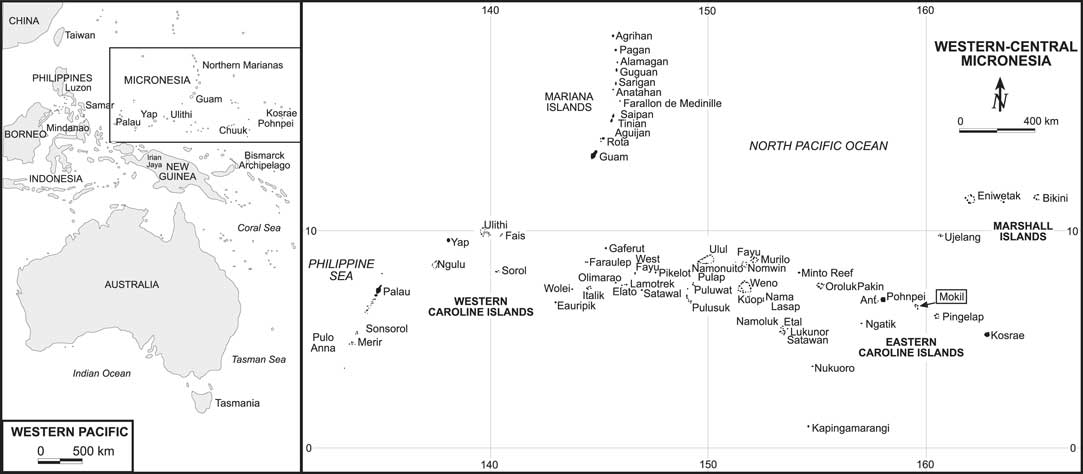
The limited research pertaining to atoll colonization and adaptation through time is even more remarkable in central Micronesia (Figure 1) where there are hundreds of atolls, most of which were occupied prehistorically; however, most unfortunately remain un- or under-investigated. To address this issue, a newly established research program has been dedicated to intensively investigate a number of atolls surrounding the high islands of Pohnpei and Kosrae. The first stage has involved several archaeological projects on Mwoakilloa (Mokil) atoll that provide an excellent opportunity to develop baseline chronologies, establish the foci of settlement on different islets, and examine the degrees to which they may have been anthropogenically altered through time.
Map of western-central Micronesia with Mokil in boxed text

RESEARCH BACKGROUND
Micronesia covers an ocean area of approximately 7,400,000 km2 (4,116 km2 of land area) and includes more than 3,000 islands, most of which are atolls or uplifted limestone. As a region, Micronesia is roughly the same size as the United States, but with a land area comparable to Rhode Island (~3,100 km2). The peopling of Micronesia differs greatly by subregion, with the western portion (Marianas, Yap, Palau) first occupied about 3000–3500 BP from somewhere in Island Southeast Asia (Craib Reference Craib1983; Rainbird 1999; Fitzpatrick Reference Fitzpatrick2003; Clark Reference Clark2005; Carson Reference Carson2008; Hung et al. Reference Hung, Carson, Bellwood, Campos, Piper, Dizon, Bolunia, Oxenham and Chi2011), and the central/eastern half settled from Melanesia (Solomons-Vanuatu region based on linguistics) between ~2000–2500 BP (Ayres Reference Ayres1990:203; Rehg Reference Rehg1995; Weisler Reference Weisler2001a, Reference Weisler2001b; Kirch Reference Kirch2010). Due to fluctuations in sea level, the number and configuration of atolls has changed over time, with the most recent emergence of eastern Micronesian atolls occurring around 2000 BP (Woodroffe et al. Reference Woodroffe, McLean, Smithers and Lawson1999; Woodroffe and Morrison Reference Woodroffe and Morrison2001; Dickinson Reference Dickinson2003, Reference Dickinson2004, Reference Dickinson2009; Woodroffe Reference Woodroffe2008), a date that generally coincides with the known settlement of the Marshall Islands, Pohnpei, Chuuk, Kosrae, and other islands in the region (Ayres Reference Ayres1990; Clark et al. Reference Clark, Petchey, Winter, Carson and O’Day2010; Weisler et al. Reference Weisler, Yamano and Hua2012; Winter et al. Reference Winter, Clark, Anderson and Lindahl2012).
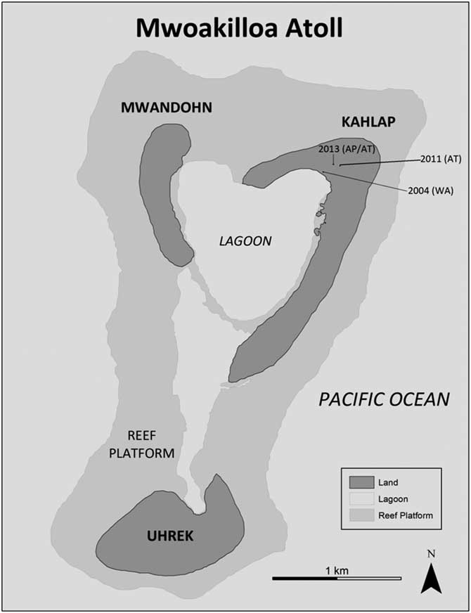
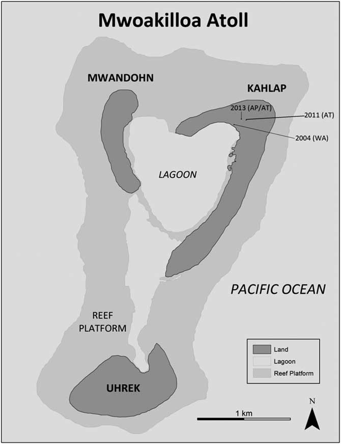
Mwoakilloa today is politically part of the State of Pohnpei in the Federated States of Micronesia (Figure 1). The island is located 166 km east of Pohnpei, 387 km northwest of Kosrae, and 115 km northwest of Pingelap atoll, and consists of three islets (Uhrek, Kahlap, and Mwandohn) that comprise a total area of 1.24 km2 (Figure 2). Archaeological research to date suggests that all three of the islets of Mwoakilloa were inhabited prehistorically, though the largest settlement has always remained on Kahlap, the largest of the three islets. Kahlap’s most prominent feature is a high artificially raised mound on which the village sits and that reaches a height of 4 m at the apex. Davidson (Reference Davidson1967:83) noted the feature had a “height greater than anything observed on the other atolls,” created through a combination of midden accumulation and possibly coral block platforms. While the size of the mound is extensive, similar deposits have been found on Kapingamarangi where excavation extended 4.6 m (Leach and Ward Reference Leach and Ward1981), with villages on other atolls being raised a more modest 1 to 2 m such as in Tokelau (Thompson Reference Thompson2010). The feature is also a result of the local community transporting coral rubble to the village area to create pathways, floors, and ground cover. Over time, the debris and platforms have accumulated in sufficient quantity to produce a large mound feature unseen elsewhere in central-eastern Micronesia.
Map of Mwoakilloa with location of test units
Oral traditions from the island indicate that people used to live on all three islets, but were in engaged in conflicts with each other that later became untenable (Bentzen Reference Bentzen1949). Historical records indicate that this led to the abandonment of Mwandohn, followed by the southern island of Uhrek, which was occupied up until the early 1900s.
Mwoakilloa has drawn the interest of a number of anthropologists over the years, though like many other atolls, this has been primarily survey work without any subsurface testing. In the 1940s, Bentzen (Reference Bentzen1949) created an anthropological documentary film about the island, reporting that the oldest part of the village was on the southern side of the main village on Kahlap, which had the richest soils. Davidson (Reference Davidson1967) spent only “a few hours” on the island, but was able to conduct the island’s first archaeological survey. She described Kahlap as having been artificially built up, with archaeological deposits about 1 m in depth. Rosendahl (Reference Rosendahl1977) mirrored these findings in his survey and collected surface artifacts, though he did not conduct any excavation.
Excavation to date has been limited to three 1×1 m test units, all of which have taken place in or around the main village on Kahlap (FMMiECH-01). W S Ayres was the first to excavate on Mwoakilloa when he opened a test unit near the lagoon side of the main village mound in 2004 (Figure 2). This was planned as the first unit in a transect across the mound. He examined deep deposits in the unit which extended down to 1.9 m and that documented historic and precontact layers. These included an occupation surface at 90 cm and related deposits extending down to 120 cm where a lagoon beach deposit extended down another 70 cm to the water table. The unit had a paucity of artifacts and cultural material in general, but significant details about the lagoon beach development. The survey of Uhrek islet demonstrated that agricultural garden pit features (taro pits) were substantial and these offer significant potential for excavation as seen elsewhere (e.g. Weisler Reference Weisler1999b).
In 2011, A Thompson opened up a unit behind the main village located adjacent to a taro patch near the middle of the island. The main purpose of the excavation was to assess the chronology of agricultural development and he subsequently found deep deposits similar to that identified in 2004, including shell tools, volcanic stone artifacts, commensal land snails, faunal remains, and burned coconut endocarp.
In 2013, A Poteate and A Thompson continued archaeological investigation with a more comprehensive survey of all of the islets for any anthropogenic modification or additional evidence of prehistoric settlement that had not been identified previously. Shovel test pits of the taro pit mounds on Uhrek and Mwandohn produced sterile soil with no cultural artifacts. It was determined that the main village on Kahlap was the best location to continue subsurface investigation as it appeared to be the longest occupied section of the island and provided easier access. Excavation in 2004 and 2011 on Kahlap had also demonstrated that the oldest areas of the island were those that were raised, and so a section of land near the highest point of the village was selected to continue fieldwork in 2013, with areas near the taro patch avoided due to the potential for mixing from cultivation. Recovered remains included stone artifacts, shell tools, burned coconut endocarp, faunal remains, and two pottery sherds.
METHODS
Excavation in 2004 and 2013 proceeded by troweling in both arbitrary 10-cm plana (levels) and stratigraphic layers. Soil was then wet-sieved through 6.3-mm (1/4″) mesh, with a 0.5×0.5 m column sample sieved through nested 6.3-mm and 1.5-mm (1/4″ and 1/16″) sieves to recover smaller site constituents. Recovered material was cleaned, dried, and sorted into basic categories (e.g. ceramics, bone, shell, and stone) in the field. Categories of material from each collected unit (planum) were placed in labeled bags and then shipped back to the University of Oregon for further analysis. Special finds (e.g. a bone tattoo needle, shell adzes, beads, and pendants from 2011 and 2013) were photographed, recorded, and then displayed in the local Mwoakilloa municipal office. The field methodology for the 2011 project was very similar to that in 2013, with the exception of the size of sieves used (1.5 and 6.3 mm). To facilitate comparison with other Pacific collections, which have often utilized 3.2-mm sieves, all 1.5-mm material was also sorted through 3.2-mm sieves in the laboratory to produce a comparable sample.
While the charcoal samples that could be used for radiocarbon dating were quite limited from the 2004 excavation, the later ones produced considerable material for dating. Charcoal samples from 2004 and 2011 were sent to laboratories at the University of Waikato (lab code WK-, New Zealand) and Beta Analytic (lab code Beta-, Miami, FL) where the labs prepped and analyzed the samples. To improve the dating assessment developed from the first two excavations, a total of six samples from the 2013 excavation were sent to Direct AMS (lab code D-AMS, Bothell, WA) for 14C dating to complement four other dates from two other labs. The charcoal and burned coconut endocarp samples from 2013 were rinsed with freshwater, dried, and placed in glass vials, while marine shell samples were washed and pretreated at the University of Oregon Island and Coastal Archaeology Lab with a 10% HCL solution, dried, and drilled to obtain a suitable sample, which was then placed in glass vials for lab submission.
RESULTS
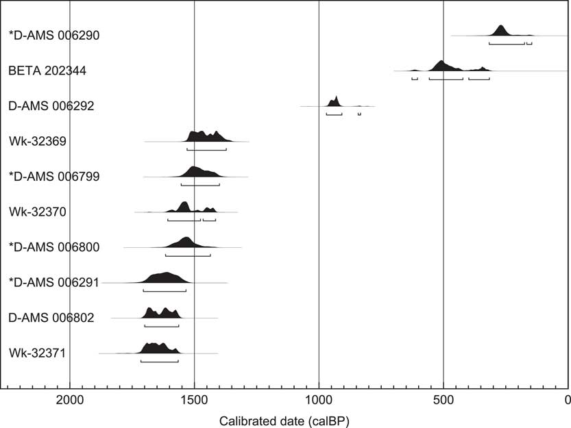
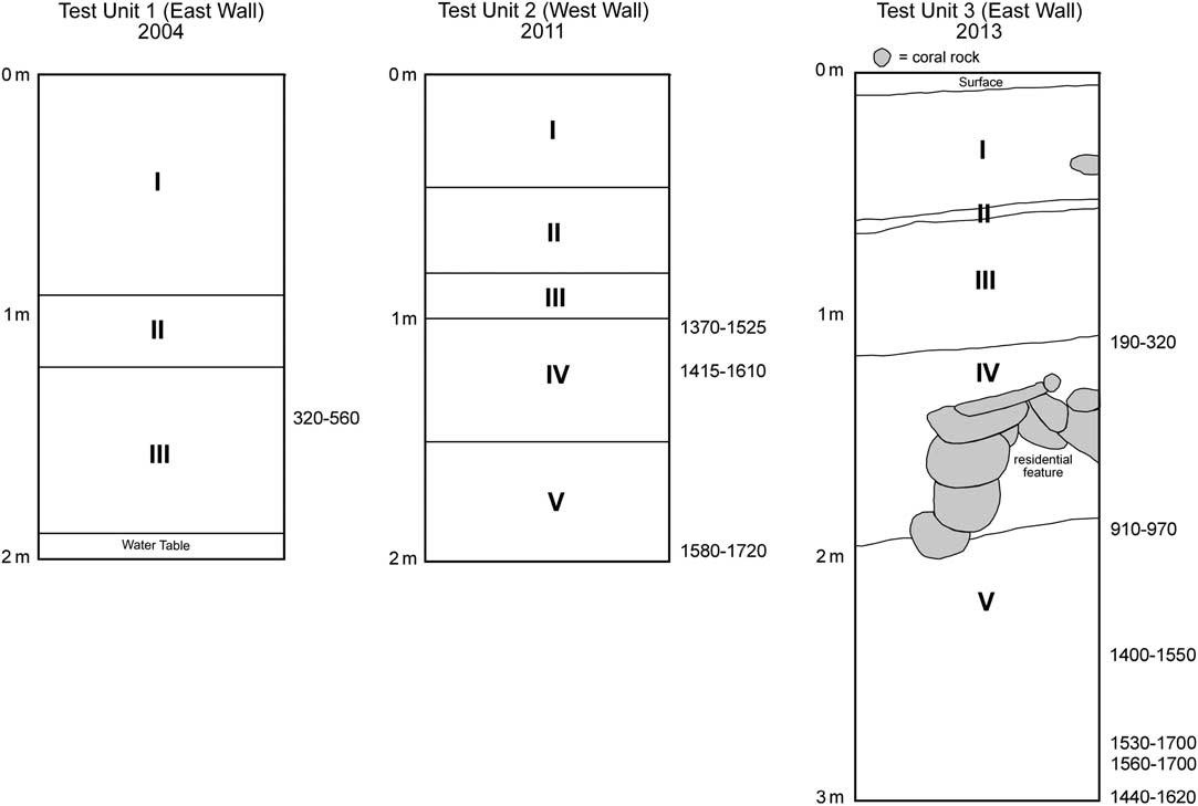
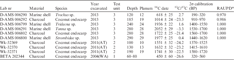
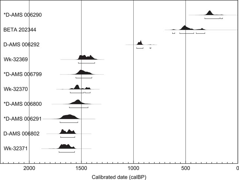
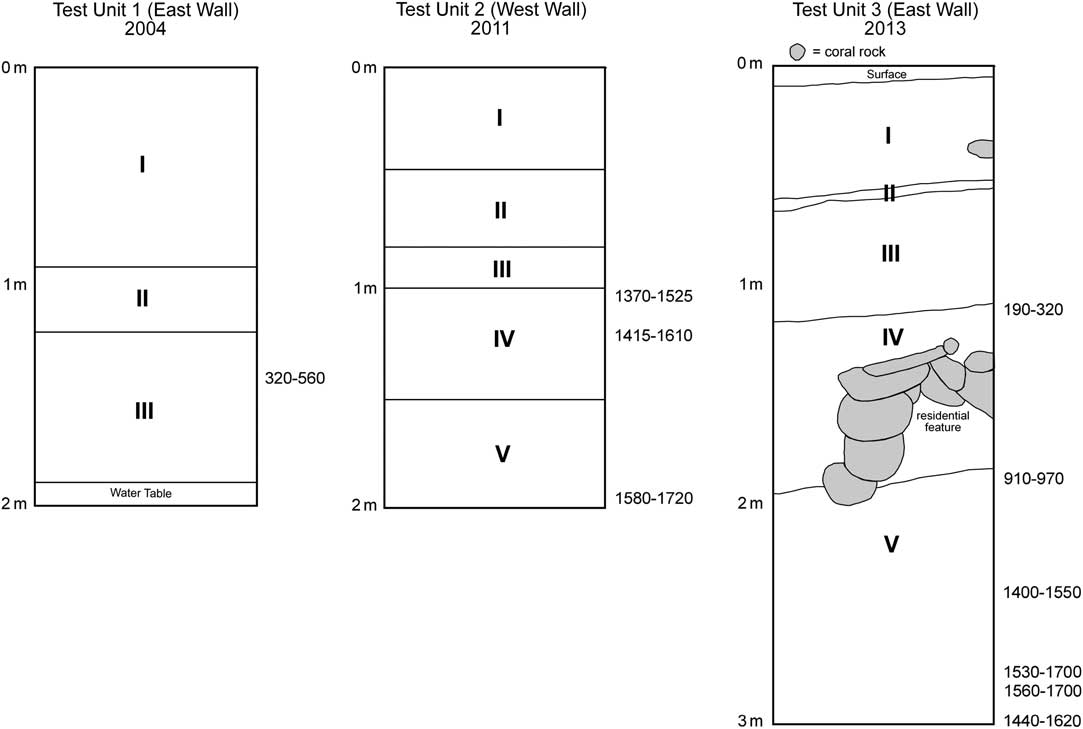
Radiocarbon dates were obtained from all three units, including seven charcoal and three marine shell samples at various depths in the excavated units (see Table 1 and Figure 3). All samples were calibrated using OxCal v 4.2 (Bronk Ramsey Reference Bronk Ramsey2009), with a global average marine reservoir effect used for marine shell as there is currently no ΔR currently available for the region (Reimer et al. Reference Reimer, Bard, Bayliss, Beck, Blackwell, Bronk Ramsey, Buck, Cheng, Edwards, Friedrich, Grootes, Guilderson, Haflidason, Hajdas, Hatté, Heaton, Hoffman, Hogg, Hughen, Kaiser, Kromer, Manning, Niu, Reimer, Richards, Scott, Southon, Staff, Turney and van der Plicht2013). The assays demonstrate that Mwoakilloa was settled at least as early as 1700–1560 cal BP (2σ), with occupation continuing up until modern times. As can be seen in Figure 4 for the main unit excavated in 2013 (Test Unit 3), the assays nicely follow stratigraphic position, with evidence for rapid accumulation of material (Layers 1–3) during the historic period through modern times. It should be noted that the ground level for the excavation in 2011 (Test Unit 2) was roughly 1 m below the ground surface for Test Unit 3 from 2013. Thus, planum 19 from 2011 [1720–1580 cal BP (2σ) and planum 28 from 2013 (1700–1560 cal BP (2σ)] are interpreted as being chronologically the same cultural deposit. The same should hold true for planum 13 from 2011 [1610–1415 cal BP (2σ)] and planum 24 from 2013 [1550–1400 cal BP (2σ)] (see Figure 4). Test Unit 3 does not present any evidence for stratigraphic discontinuity beyond the second layer. Layer 2 is a distinct sandy layer covering the entire unit present in Test Units 2 and 3 at approximately the same depth (50–60 cm). We suggest this layer represents the aftermath of a 1775 typhoon that killed most of the island’s inhabitants (Bentzen Reference Bentzen1949); additional sediment testing and micromorphology studies are needed to test this hypothesis. Test Unit 3 included a residential feature of coral blocks in Layer 4 that was interpreted as part of a platform mound or housing structure. The profiles of the test units also show the expansion of the island toward the lagoon over time as would be expected through typical geomorphological processes (Woodroffe Reference Woodroffe2008). The 2004 test unit, near the present lagoon shore, shows the progradation of the atoll based on the younger date and primarily natural deposits as would be expected based on prior research (Riley Reference Riley1987).
Radiocarbon dates from Mwoakilloa calibrated with OxCal v 4.2 using the IntCal13 atmospheric curve (Reimer et al. Reference Reimer, Bard, Bayliss, Beck, Blackwell, Bronk Ramsey, Buck, Cheng, Edwards, Friedrich, Grootes, Guilderson, Haflidason, Hajdas, Hatté, Heaton, Hoffman, Hogg, Hughen, Kaiser, Kromer, Manning, Niu, Reimer, Richards, Scott, Southon, Staff, Turney and van der Plicht2013). Range bars represent the 2σ confidence interval. *Marine samples calibrated using the Marine13 marine curve.
Profile of Test Unit 1, 2, and 3 with associated radiocarbon dates (cal BP)
List of radiocarbon dates from Mwoakilloa. *All samples calibrated with OxCal v 4.2. **Relative area under probability distribution.

While analysis of faunal remains is still ongoing, two commensal animals [Canis lupus familiaris (dog) and Rattus exulans (Polynesian or Pacific rat)] were identified in the earliest anthropogenic layers of Test Unit 3 [1560–1700 cal BP (2σ)] and provide evidence for their early presence on the island. Sus scrofa (pig) and Gallus gallus (chicken) are absent in all units, though this is not entirely unexpected given their paucity in many central Micronesian sites. Commensal land snails associated with agricultural production showed a increase in both the 2011 and 2013 excavations and are interpreted as an increase in agricultural production around 900 BP. Two small pottery sherds of plainware were found 2.6 m below the surface in TU3 directly above a planum that dated to 1560–1700 cal BP (2σ), indicating that they were imported from one of the volcanic high islands such as Pohnpei or Kosrae as there is no clay locally available. The same would hold true for volcanic stone artifacts found in the 2011 excavation in plana 11 and 17 (interpreted as coming from the same time period as the pottery), and 2013 excavation in plana 9, 11, 13, 14, 17, which appears may cover a longer timespan. Future mineralogical and geochemical analysis of pottery and stone should help to determine their provenance.
DISCUSSION AND CONCLUSION
While Dickinson (Reference Dickinson2003, Reference Dickinson2004, Reference Dickinson2009) has argued for an emergence of coral atolls in eastern Micronesia only after the last Holocene drop in sea-level stand, ~2000 to 2500 BP, Kench et al. (Reference Kench, Owen and Ford2014:7) maintain that smaller islands such as Jabat in the Marshalls emerged at a much earlier time (~4500 BP) even with higher sea-level stands in the late Holocene. This reflects some of the complexity of coral island formation and reinforces the notion that an island-specific assessment of emergence relative to human habitability may be necessary. The timing of human expansion as atolls stabilized (based on Dickinson’s timeframe) suggests that these low-lying islands provided the necessary stepping stones, stopovers, and/or safety nets that allowed for movement into more remote areas of the Pacific (Gladwin Reference Gladwin1970).
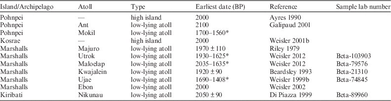
Radiocarbon dates obtained from recent excavations on Mwoakilloa document that the atoll was settled as early as 1700 cal BP, as evidenced from two dates from charcoal (D-AMS 006802; Wk-32371) and one marine shell (D-MAS 006291) in the lowest levels of excavation. While additional subsurface investigation and 14C dating are necessary to confirm this, these two assays, along with two other dates in the lowest 50 cm of Unit 3 from 2013 (D-AMS 006799; D-AMS 006800) and two from one of the earlier projects (Wk-32369; Wk-32370), provide good evidence for settlement at least between ~1500–1700 cal BP. If correct, this earliest phase of occupation would only be a few centuries after initial settlement of the nearby high islands of Pohnpei and Kosrae (~2000 BP) (Athens Reference Athens1985, Reference Athens1990; Ayres Reference Ayres1990), suggesting that Mwoakilloa, like the Marshalls (see Table 2), had a long period of occupation prehistorically on a land mass that many researchers have often considered to be marginal or unsuitable.
Early dates from islands in central and eastern Micronesia (*calibrated at 2σ).

The discovery of dog and rat in the earliest layers of human occupation on Mwoakilloa also provide further support that commensals were an integral part of human expansion into the Pacific Islands (Matisoo-Smith Reference Matisoo-Smith1994, Reference Matisoo-Smith2007, Reference Matisoo-Smith2009). Future research will be dedicated toward expanding subsurface excavations on Mwoakilloa as well as other atolls to develop much needed baseline chronologies and provide a comparative perspective for when atolls in the region were settled, subsequent adaptations in the form of subsistence strategies, and the degree of interaction that occurred between these and the larger high islands.
ACKNOWLEDGMENTS
We would like to thank the people of Mwoakilloa for hosting our projects. In particular, Chief Magistrate Ruly Neth, former Chief Galen, Kalio Lebehn, and Theo. Staff members of the Pohnpei State Historic Preservation Office, especially Roseder Lemuel and Jason Lebehn, were particularly important in setting up this research. Funding for Ayres’s work came from a Columbia University grant aimed at historic preservation training in Pohnpei State. This work could not have been completed without field assistance from Yvonne Neth and Quent Winterhoff. Emily Thomson and Erik Lash contributed to the later field studies. The 2013 fieldwork was funded by grants from the University of Oregon Center for Asian and Pacific Studies and the TS Micronesian Exploration Fund and was assisted by Emily Gibson. Three anonymous reviewers provided helpful comments and suggestions, which helped to clarify various points in the paper.