1. OUTLINE OF THE BERING SEA
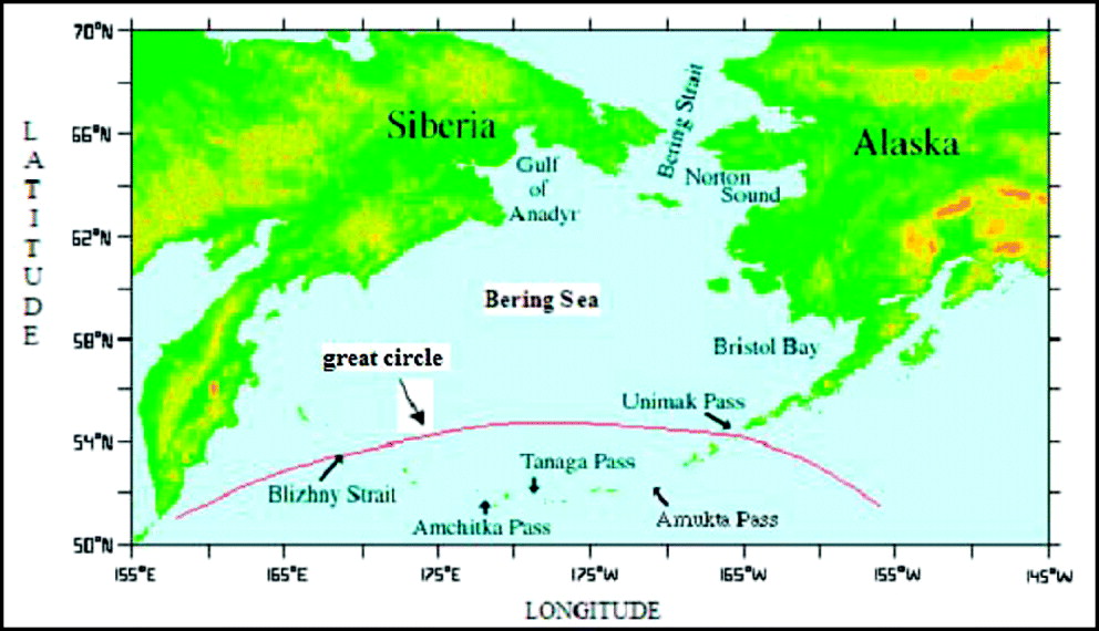
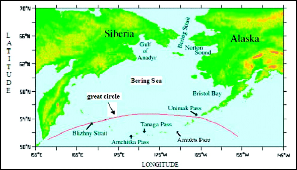
The Bering Sea is the northernmost part of the Pacific Ocean. It borders Asia to the west and North America to the east. Through the Bering Strait in the north it connects with the Arctic Ocean, while in the south the sea boundary arches along the Alaska Peninsula, the Aleutian Islands and the Commander Islands. Although the topography of the Bering Sea bottom varies a lot, it can be divided into two basic, almost equal parts. One is a deep basin including southern and western waters of the sea, with depths of 3000 m to 4000 m, the other, eastern and northern region is the shallow continental shelf in some places only exceeding a depth of 150 m. The exchange of waters with the open ocean takes place mainly between islands of the Aleutian Archipelago and through Kamchatka Strait; in the north its waters blend with the Arctic Sea through the Bering Strait [1]. Shipping channels between the Pacific and the Bering Sea run through several straits: Unimak Pass, Amukta Pass, Tanaga Pass, Amchitka Pass and Blizhny Strait (Figure 1).
Major passes between the Pacific Ocean and the Bering Sea [3].
The Bering Sea abounds with fish, crabs and other crustaceans and in this respect is regarded as one of the best and largest fishing grounds in the world. It is estimated that about 10% of the world's “fruit of the sea” comes from that area. The rich variety of birds, mammals and other animals present in the Bering Sea find favourable habitats in that ecosystem.
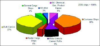
Significant vessel traffic on the Bering Sea can be divided into two main groups. One consists of large cargo vessels that sail between northern ports located on the western coast of North America and the Far East [2]. Those ships principally choose the shortest routes along the great circle that runs through southern areas of the Bering Sea (Figure 1). Notably, the traffic mostly moves from America to Asia, as ships take advantage of the anticlockwise circulation of surface waters and the surface Alaska Stream flowing westward. Ships proceeding from Asia to America, in turn, rarely enter the Bering Sea, as they prefer to benefit from the clockwise circulation of surface waters of the North Pacific and the North Pacific Current, flowing south of the Aleutian Islands, known as the Kuroshio Extension. Besides, some ships on the Pacific decide to enter southern areas of the Bering Sea to sail farther north, which enables them to avoid unfavourable stormy hydro-meteorological conditions that prevail further in the south. See Figure 2 for the breakdown of traffic through the Unimak Pass.
In the other group of smaller ships are fishing vessels and other vessels making use of the marine riches as well as other craft, such as seismic and survey vessels. While cargo ships proceeding along the great circle rarely cross latitude 55°N, fishing and specialized craft operate within almost the entire area of the sea. The best fishing period falls around autumn and winter at which time these vessels encounter very difficult navigational conditions, including drifting sea ice.
Trans-Pacific vessel traffic through Unimak Pass from October 2005 to June 2006 by vessel type [4].

2. ICE SEASONS
Due to the northerly location of the Bering Sea, ice occurs there every year, melting in spring. Depending on the severity of winter, the width of fast ice belt and the density of floating ice pack vary, nevertheless they always hinder navigation. Ice in the Bering Sea is of local origin. Amounts of Arctic ice pack seldom appear as the narrow Bering Strait, connecting the two seas, freezes nearly every winter and thus makes a natural obstacle.
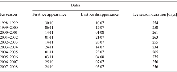
In the ice seasons 1998/9–2007/8 the dates of ice appearance and complete melting as well as ice periods varied significantly (Table 1). In three seasons ice appeared as early as late October (earliest on 24th October in the 2007/08 season), while in the other seven seasons first ice was seen on 24th November at the latest in the 2003/04 season). The difference between these two extreme dates is 32 days.
Selected data on the Bering Sea ice cover in 1998/9–2007/8 [5].
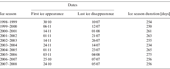
In eight seasons ice vanished in July (the earliest date was 5th July 2008), while in the other two seasons the ice disappeared in August (4th Aug at the latest in the 2005/06 season). The difference is 31 days.
The length of ice period in most cases is related to either the early appearance of the first ice or late disappearance of the last ice. The shortest ice period lasted 234 days (2003/04) and was connected with late appearance of first ice (24th November), while the longest period was 275 days (2005/06) due to relatively early formation of ice (3rd November) as well as late melting of last ice (4th August). The difference between the shortest and longest ice season is 41 days.
3. ICE EXTENT
First ice in the Bering Sea, which generally begins to form along the coasts, occurred most often in its northwest part, i.e. the Gulf of Anadyr, then a few days later in its northeast area known as Norton Bay. Moving gradually south, ice reached Bristol Bay in the east and Kamchatka Peninsula in the west.
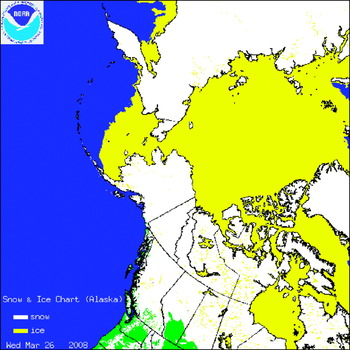
Depending on the severity of winter, the size of ice covered waters and its range varied across the seasons. The largest area of ice cover occurred in the winter season 2007–2008, when on 26th March 2008 almost half of the Bering Sea was under ice, in the east extending below latitude 55°N (Figure 3) [5]. In two other ice seasons: 2000–2001 and 2002–2003 the ice extent was relatively small, as in the eastern part it did not cover the whole Bristol Bay, which remained navigable through those two seasons. Small ice areas formed only close to the coastal belt of the bay.
Maximum ice extent in the Bering Sea on 26 March 2008 [6].

In most seasons of the ten-year period ice began to melt in early April. The process was quick so that in late June or early July almost the entire sea was free of ice. Its remains could only be found near Bering Strait and along the shores of two bays in the north west and northeast parts of the Bering Sea.
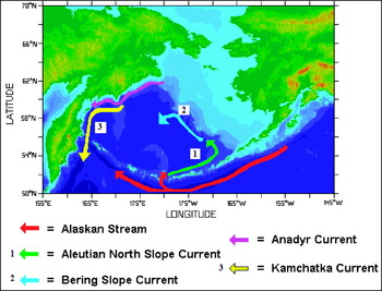
The southern part of the Bering Sea from approximately the latitude 55°N parallel was not frozen in any of the analyzed winter seasons. That may have been due to higher air temperatures that prevail there and much greater depths – the source of warmer water coming up to the surface, a phenomenon that does not take place in the shallow continental shelf of the northern and eastern parts. Another reason may be sea currents connected with the surface circulation of ocean waters. One such current is the warm Aleutian North Slope Current flowing eastward along the northern boundary of the Aleutian Archipelago. The current gradually changes its direction towards the north and thus originates the Bering Slope Current, moving northwest along the continental shelf limit and the deep basin. As its waters get colder, the current further flows southwest along Kamchatka coasts, then it continues south as the cold Kamchatka Current or Oja Siwo (Figure 4). That anticlockwise circulation of surface waters in the southern and western part of the Bering Sea keeps that sea area free from fast ice.
Major currents of the Bering Sea [3].

4. CONCLUSION
Waters of the Bering Sea are covered with ice every year, which potentially hampers the developing vessel traffic. Expansion, growth of the survey and seismic fleet related with the increased demand for the resources of this sea push vessels to navigate in waters where previously traffic was scarce. In the investigated period part of the sea south of the parallel 55°N remained non-frozen, a fact used by cargo vessels proceeding along the great circle. In the other part, particularly the Gulf of Anadyr and Norton Bay, ice was present for a long time, i.e. about eight months of the year. Consequently, navigational conditions there were difficult as vessels faced the risk of getting caught in ice or loss of time due to excessive icing.
We can expect that possible recommendations and good sea practice to be observed in ice-affected waters may soon be reflected in international regulations. If a relevant revision of these regulations is adopted, new opportunities for maritime training centres will arise, as specialized training will have to be provided for personnel of ships operating in such sea areas.