1. INTRODUCTION
In this study a real time dynamic navigation support model is developed for navigating vessels in narrow channels. The model is tested on the Strait of Istanbul (Bosporus) using the Strait geometry, counter traffic and the surface currents as the disturbances. The surface currents are treated as a random variable whose magnitude is normally distributed. The vessel trajectories are projected with respect to the discrete current magnitudes. By using a set of possible intended courses, probability distribution of current magnitudes and initial vessel positions, corresponding vessel trajectories are simulated. The grounding and collision probabilities are calculated for each trajectory. Finally, the trajectory with the lowest corresponding casualty probability is proposed as the safest for the navigating vessel. In the case of more than one safe manoeuvre, tie-breaker criteria are employed to select the best among the possible intended headings.
After the model validation, some case studies are performed and the model successfully to proposes a safe route in every case. Full Strait simulations are also performed where the vessels navigate from the entrance to the exit assuming that the vessel always follows the proposed route. These simulations are also used to assess the legal policy implications in the Strait.
The paper outline is as follows. First, a literature review on narrow channel navigation is presented. Then, the methodology, including decision and hydrodynamic model, is discussed in detail. Finally, a case study using the proposed model is performed for the Strait of Istanbul. The model is tested for different scenarios. Finally, conclusions of the model test results and model limitations are discussed.
2. LITERATURE REVIEW
Statheros et al (Reference Statheros, Gareth Howells and McDonald-Maier2008) provides a comprehensive review of models and approaches for collision avoidance, covering different approaches such as mathematical modelling of ship dynamics, neural networks, fuzzy logic, evolutionary algorithms and hybrid models. However, the emphasis is not specifically on narrow channel navigation. Nevertheless, the studies on navigation in narrow channels also focus on the same issue: avoiding collision through the channel. Not all the studies in narrow channel navigation address the hydrodynamic effects as a major concern but focus more on the technological developments and policy considerations. Reid et al (Reference Reid, Judson and Smith1998), mainly motivated by the Valdez super-tanker casualty, discuss the benefits of the Maritime Navigation Safety System (MNSS) for Canadian coasts. Paul (Reference Paul1997) investigates the policy implications for Tsushima Strait, Korea. Inoue (Reference Inoue2000) approaches the navigation difficulty in restricted waterways from the mariner's perception of safety. El-Kader et al (Reference El-Kader, El-Soud, El-Serafy and Hassan2004) study the Suez Canal with deployment of DGPS and LORAN-C systems to better track the navigating vessels. Kharchenko and Vasylyev (Reference Kharchenko and Vasylyev2004) propose a decision model to maximize the capacity of narrow waterways by keeping the distance between two consecutive vessels to a minimum, using a Kalman filter. Bhattatacharya et al (Reference Bhattatacharya, Scarlett and Gautier1996) investigate artificial intelligence techniques for tracking vessels in VTS radars, which are directly related to narrow water navigation. Le et al (Reference Le, Do, Pham, Nguyen, Hoang, Vu and Duong2003) (and the references therein) define the Marine Intelligent Transportation Systems concept which is very relevant for the current study. They propose a fully automated marine transportation system and study the traffic control system components for congested waterways. They suggest integration of radars, Automated Identification Systems (AIS) and such technologies for advanced VTS systems. They propose the use of computer simulations of marine traffic flow as the first stage for real life management applications. As a second stage, they suggest application of the models to real ships. In that respect, the current study is a promising effort towards the first stage, in which the proposed model is tested for virtual scenarios.
In the current study, the Strait of Istanbul is chosen for the model application because of its unique features such as passing through a large metropolitan city and also for its strong surface currents making the Strait one of the hardest narrow channels to navigate. Solely for the Strait of Istanbul, there are numerous studies focusing on the vessel traffic. Most of them use statistical analysis for the casualty risk and try to predict the number of casualties, or focus on the vessel queuing at the Strait entrances to maximize the vessel flow capacity. Kornhauser and Clark (Reference Kornhauser and Clark1995) exploit a regression model prepared by the United States Department of Transportation for the U.S. Coast Guard Office of Navigation Safety and Waterway Services to forecast the number of casualties in the Strait of Istanbul. The model ignores time variations in the distributions of vessel sizes and arrival rates. Instead, it only incorporates past data including the past casualties, channel width, average current velocity, wind velocity, visibility etc. It also assumes that the casualty rate is independent from the volume of traffic and therefore tends to underestimate the number of casualties that result from the increase of oil tanker traffic. Kahraman (Reference Kahraman1999) and Goren (Reference Goren2002) investigate the Bosporus by data regression and statistical simulations and propose descriptive models for the safety of the Strait. Almaz et al (Reference Almaz, Or and Ozbas2006) use ARENA to simulate the vessel traffic. Although currents are incorporated in the simulation, current forces are only introduced to affect the navigation speed of the vessel. The current drift force, an important mechanism regarding casualties, is not considered. Kose et al (Reference Kose, Basar, Demirci, Guneroglu and Erkebay2003) study the relationship between the arrival rate and the waiting time of the ship via simulation. However, no detail is given about the underlying hydrodynamic model for vessel navigation.
Sarıöz et al. (Reference Sarıöz, Kükner and Narlı1999) perform a real time ship manoeuvring simulation investigating the performance of large tankers in the Strait. The study verifies the present regulations' assumption that ships longer than 200 metres cannot keep within the traffic lanes safely, even in no current conditions. Smaller ships are capable of keeping within the traffic lanes; however they depend on pilotage skills. Ince and Topuz (Reference Ince and Topuz2004) propose a safe navigation model design within Vessel Traffic Management and Information System (VTMIS) incorporating the vessel arrivals as well as the hydrodynamic force mechanisms. However, the hydrodynamic simulations are based on pre-determined scenarios, tested with Marine Navigational Simulators (MNS). Although MNS give very realistic and reliable outcomes, their runtimes are not sufficiently small to support a real-time decision. Tan and Otay (Reference Tan and Otay1999) also propose a physics-based model for determination of spatial risk distribution in narrow channels. Markov chain analysis is performed with the help of state space representations of vessel positions. Their outcome coincides with the results of Brito (Reference Brito2000), who approaches the congestion of vessel traffic in the Strait of Istanbul from an economic and political perspective with a Markov chain model. Both studies end up with the result that there is a quadratic relationship between the volume of the traffic and the casualty risk. Özkan (Reference Özkan2003) investigates the spatial distribution of the casualties in the Strait of Istanbul incorporating a CFD based ship navigation model, focusing on pilotage behaviour and errors. In his work, the pilotage is treated as a stochastic process, which causes an uncertainty in the ship manoeuvring for given surface current conditions. The position distributions, which are the result of the pilotage differences, are used to find the casualty probabilities. The high casualty risk regions found through the model match with the real life data. Overall, the current study uses an evolutionary approach similar to Smierzchalski and Michalewicz (Reference Smierzchalski and Michalewicz1998), however the probabilistic position distribution concept introduced in Özkan (Reference Özkan2003) is employed for the analysis.
3. MODEL DEVELOPMENT
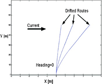
The present model is based on consecutive vessel navigation simulations that span the Strait by route trajectories corresponding to predetermined intended headings. Probabilistic surface currents are introduced as an external force that drifts the vessel from its original course. Figure 1 represents the drifted trajectories under the same intended course for three different horizontally aligned current magnitudes. As the final outcome, the model chooses the safest intended heading depending on the casualty probability calculated for that specific course of the vessel. The safest route updates are made on pre-defined check lines along the channel. At each check line vessel parameters such as speed, position, yaw angle etc are supplied to the model to re-assign the safest route. The terminology used for collision avoidance in the literature is mainly Own-ship (the ship to be navigated) and Target-ship or strange-ship (the ship to be avoided) (Statheros et. al., Reference Statheros, Gareth Howells and McDonald-Maier2008). This current study assumes a simultaneous assistance to two oppositely navigating ships and safe routes are determined based on both vessels' simulated trajectories.
Illustration of vessel drift with changing current magnitudes.

In the model, the possible headings to be supplied to the model are found through adding and subtracting small angle deviations from the channel alignment. This provides possible vessel trajectories that are reasonable in terms of channel geometry.
3.1. Route Generation
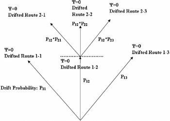
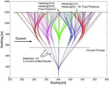
Figure 2 shows the probability assignments for the drifted routes. P ij stands for the probability of a vessel navigation ending up at a specific position on the next check line, where i represents the region that the vessel navigates through, and j represents the drifted trajectory as a result of the currents experienced by the vessel at region i. The simulation is extended to reach the second check line in a consecutive manner. The resulting trajectory tree can be expanded until it is sufficient to support a rational decision. There are 12 fixed check lines in the model that correspond to 12 major manoeuvre points along the Bosporus. In our case for the Bosporus the trajectory tree is constructed for two check lines allowing two course adjustments per trajectory. Normally, 2 check lines cover around 1 km long range (~0·5 miles after each manoeuvre) per simulation. However if the vessel approaches a major manoeuvre point, one of the check lines is set as the existing fixed check line to be able to let the vessel obey the physical manoeuvring constraints imposed by the Strait geometry. Likewise, if there is another ship approaching from the opposite direction, the check lines are located so that the vessels make two manoeuvres before they meet. Briefly, the check lines other than the fixed ones, are placed according to external conditions via changing the simulation time for each manoeuvre. The calculation for position probability distribution of the vessels at check lines can be found in Figure 2 and trajectory tree of consecutive simulations can be seen in Figure 3.
A sketch of route probability assignments.

Trajectory tree formed after two consecutive 100 seconds-long simulations with five headings and three current magnitudes.

3.2. Probability Calculations
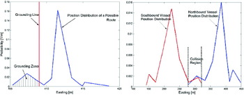
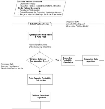
After all the position distributions for the routes are found, a post-processing unit uses the distributions obtained to calculate the grounding and collision probabilities for each route (Figure 4). The area under the position distribution, which falls on land, is used to calculate the grounding probability and the area under the intersection of two ships navigating in opposite directions is defined as the collision probability. When position probability distributions of two oppositely navigating vessels intersect on land, the area under the curves is disregarded since there cannot be collision on the shore. This intersection is used only for the grounding probabilities. This also allows the treating of grounding and collision as two distinct events which simplifies the probability calculations. The detail of how the probabilities are used to propose the safest route is given in Section 4. It should be noted that the position probability distributions of vessels at the check lines are discrete, since the current distributions that results in those position distributions are also discrete. The ship's position for each trajectory is represented by a single point corresponding to its centre of mass within the equations of motion. The point representation can easily be extended to include ships breadth by adjusting the position distribution plots, or can be translated to any part along the hull. However, since the model uses the probability distribution of all possible positions of the ship, including breadth introduces a negligible change in terms of the probability calculations.
Calculation of grounding and collision probabilities.

4. DECISION MODEL
There are two subroutines of the decision-making process written for two different casualty threats. It is assumed that when the distance between two vessels is greater than a pre-assigned threshold, d critical, there is no collision risk in near future. When two vessels are closer to each other than d critical, both collision and grounding probabilities exist. Thus, if the distance between the two ships navigating in opposite directions is above d critical the Grounding Only algorithm is employed. However, if the distance is less than d critical, the Collision Combined algorithm, which takes the collision probabilities into account as well as grounding, is used for the analysis. The flowchart of the model is given in Figure 5.
Flowchart for the proposed model.

The major rule for manoeuvre selection for both algorithms is to choose the manoeuvre that will result in the minimal casualty probability. Besides, both of them use the same logic for selecting the safe intended course from corresponding quasi-risky routes. The quasi-risky term is introduced because on some occasions two routes may have close accident probabilities. Two trajectories with the same accident probabilities within a certain interval, say, are assumed to be quasi-risky and they are assigned to be the optimal candidates. In such cases both algorithms use the criteria explained below, to select among the quasi-risky routes.
• The projected trajectories with intended headings equal or close to the longitudinal orientation of the channel are preferred.
• If the above constraint is satisfied by more than one route, the route with the minimum number of course alterations is chosen.
• If there is still more than one candidate, the route with end point having greatest distance from the channel borders is selected.
4.1. Grounding Only Algorithm
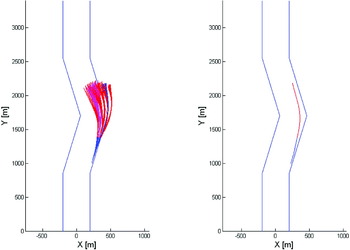
The Grounding Only algorithm processes only the grounding probabilities. Figure 6 illustrates how the tie-breaker criteria are employed for the selection among the quasi-risky routes. There are courses which are further away from the borders than the proposed safe course, however, if a vessel is to follow one of these eliminated courses, it will have a different yaw angle at the end. This will make it much harder to adjust the vessel for the next corner, because the vessel has to make a sharp move to be able to complete its manoeuvre at the next turn. Thus, the safest course is selected to be closer to the shore but still safer because of the navigational aspects mentioned above.
An Illustration of safe route selection with Grounding Only algorithm.

4.2. Collision Combined Algorithm
The Collision Combined optimization differs from the grounding only algorithm by avoiding collision as well as grounding. One vessel can avoid the other easily by performing a certain manoeuvre, however this may result in grounding. Thus, the total accident probability incorporating both accident types is employed. The total grounding probability of two vessels, which gives the probability of at least one vessel grounding, is:

where subscripts i and j represent the selected trajectories for northbound and southbound vessels respectively. Please note that the calculated grounding probability depends on the manoeuvre pair of both vessels rather than individual grounding probabilities. Thus, subscripts i and j (representing northbound and southbound proposed manoeuvres) are introduced to distinguish from individual grounding probabilities. The total casualty probability is calculated as follows:

Since collision and grounding cannot happen simultaneously, probability of casualty can be written as:

The casualty probability by definition depends on the manoeuvre pairs, thus again presented with subscripts.
In the case of multiple candidate manoeuvres which are defined as quasi-risky, tie-breaker criteria are employed. However, for the Collision Combined algorithm, the minimum distance between the vessels is considered first for elimination instead of setting a minimum number of manoeuvres as the second tie-breaker rule, as is used in the Grounding Only algorithm. This is due to the need to set two vessels apart from each other at the end of their manoeuvre.
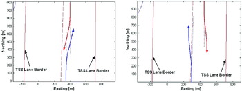
Apart from the mathematical calculations, the model also uses International Regulations for Preventing Collisions at Sea (COLREGS) while providing guidance. For instance, Figure 7 illustrates a condition where two vessels approach each other. Both vessels are proposed a starboard manoeuvre for a safe passage (Figure 7, left hand side). The proposed safest route is based on COLREGS Rule-14Footnote 1 (starboard manoeuvre) if it is possible. If the positions of two vessels are too close to each other so that a starboard manoeuvre cannot be performed safely, then the algorithm proposes a port manoeuvre instead (Figure 7, right hand side) following Rule-8Footnote 2 with trajectories that are distant from each other.
An illustration of safe route selection with the Collision Combined algorithm.

5. HYDRODYNAMIC MODEL
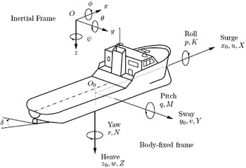
Modelling of ship movement and manoeuvring is an important part of this work. The desired model should produce trajectories including current drift forces in a reasonable time to support real time decision making. The standard six degrees of freedom representation with standard notation and sign conventions for ship motion can be seen in Figure 8. For this study, the four-degrees of freedom (surge, sway, yaw and roll) container ship model, provided in MATLAB Marine GNC toolbox (Fossen and Perez, Reference Fossen and Perez2004) is used. The hydrodynamic model used in the Marine GNC toolbox is based on a state-space representation which gives the model flexibility to introduce external forcing mechanisms easily. This flexibility was used to introduce stochastic drift forces caused by the surface currents. The physical characteristics and hydrodynamic coefficients of the container ship model that is used in this study can be found in Fossen (Reference Fossen and Perez2004).
Standard notation and sign conventions for ship motion description (Source: Perez and Blanke (Reference Perez and Blanke2000)).

Assuming that heave and pitch motion will not affect the system considerably, the following equations can be written:

Then we can write the equations of motion in 4 DOF as follows:

where m is mass of the ship, I xx and I zz are the inertias about the x 0 and z 0 axes, and x G and z G are the coordinates of the centre of gravity CG with respect to the body-fixed frame, i.e., CG=[xG, 0, zG].
The container model takes vessel position vector as an input and processes this vector to find the vessel trajectory regarding the given intended course. The position vector used by the container ship model is shown below:

where: u is surge velocity (m/s), v is sway velocity (m/s), r is yaw velocity (rad/s), x is position in x-direction (m), y is position in y-direction (m), ψ is yaw angle (rad), p is roll velocity (rad/s), ϕ is roll angle (rad), δ is actual rudder angle (rad), n is actual shaft velocity (rpm).
Some of the parameters in the position vector such as surge-sway velocity and x-y position can be easily gathered from VTS, or from a GPS device on the ship. Obtaining the rest of the parameters needs implementation of simple additional information gathering tool. As studied in Le et.al. (Reference Le, Do, Pham, Nguyen, Hoang, Vu and Duong2003) such technologies are viable implementations within the Marine Intelligent Transportation Systems framework such as Automatic Identification Systems (AIS) and Visual Vessel Traffic Systems (V-VTS). Briefly, the model parameters are measurable and can be gathered and used as an input to the proposed model.
5.1. Current Forces
The model uses surface currents as a disturbance to the ship's course. Current magnitude and direction distribution is given as an input to the model. The current drag force that drifts in vessel route is calculated with the formula (7):

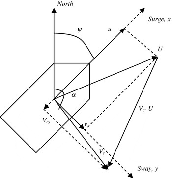
where C D is the drag coefficient, D is the ship draft, L is the length of the ship, U is the speed of the ship,  is the current velocity projected into ship's sway direction, and
 is the velocity of the ship in sway direction. (Figure 9).
Two dimensional representation of forces acting on a ship.

5.2. Auto Pilot
For the current study, a proportional derivative (PD) auto pilot that exists in Marine GNC Toolbox is employed. The control rule is given with the following formula:

where: K p, T d are Feedback gains, δ is Rudder command, ϕ is Ship's heading, ϕref is intended course, r is Yaw velocity.
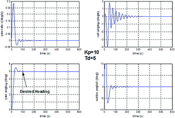
Here, the feedback gains K p and T d, can be thought of as a model for pilotage skills. Modelling of human pilotage behaviour requires a serious amount of pilotage tests and complex modelling, which is beyond the scope of this study; hence the gains are tuned to reasonable values to match some performance criteria in a heuristic manner. The time constraint is very important, since the navigation is in a narrow channel and unlike the open sea, the intended course must be maintained rapidly to avoid any grounding. However, this kind of enforcement can result in rudder adjustments that are not realistic to maintain. Thus, several adjustments in feedback gains must be set according to the desired amount of time, which also equals to a certain distance according to the ship speed. Figure 10 shows one output of a feedback tuning, where the intended heading (defined as desired heading in Marine GNC toolbox Auto-Pilot) is achieved around 100 seconds and rudder angles are acceptable in terms of real life implementation. In this study, K p=10 and T d=5 are found to perform satisfactorily for the Strait of Istanbul.
Auto-pilot response test results.

6. MODEL TEST IN THE STRAIT OF ISTANBUL
The Strait of Istanbul (Bosporus) is one of the most difficult channels in the world to navigate due to its geometry with sharp and narrow turns as well as its vulnerability to environmental effects (Akten, Reference Akten2004) (See Figure 11). The surface current flows almost invariably setting southward with a speed of 8 knots, driven by the difference of water levels at the northern (Black Sea) and southern (Marmara Sea) openings. The water in the lower layer flows in the opposite direction driven by the salinity difference between Marmara and Black Sea. This two-layer flow structure affects the current characteristics of the Strait, but the bottom layer flow does not directly affect the ship navigation through hydrodynamic forcing mechanisms. Several studies (Yuksel, et al., Reference Yuksel, Ayat, Ozturk, Aydogan, Guler, Cevik and Yalciner2008, Dogan and Burak, Reference Dogan and Burak2007, Kiratli et. al., Reference Kiratli, Cagatay, Polat, Balkis and Orhon1997) cite two-layer flow interface depths between 15–40 m, varying along the Strait (due to bathymetry, proximity to Marmara and Black Sea) and between the seasons. Given the current regulations not allowing vessels more than 300 m in length to pass, and the statistics of the vessel characteristics/sizes (Sarıöz et.al., 2000) that pass through Bosporus, the probability of a vessel with more than 15 m draft passing Bosporus is very low. In other words, the proposed model based on surface currents is valid for a high percentage of ships passing through the Strait. On the other hand, the existing literature also does not mention bottom layer flow as a potential factor affecting ship navigation or maritime accidents (Akten, Reference Akten2004). Even in the detailed simulation studies (Sarıöz et.al., 2000), bottom layer flow is not considered for the case studies. The current study also follows the same practice and does not consider bottom layer flow in the analysis. However, due to a lack of more comprehensive data, the surface current magnitude fluctuations are assumed to vary 40% in an hour, which is based on bottom flow fluctuations found in the Istanbul Rail/Tunnel Consultants Consortium's hydrographic survey (1987).
Satellite photo for Strait of Istanbul.

6.1. Model Validation
In this section, the developed model is applied to the Strait of Istanbul with several case studies, where a few selected instances will be presented to show the abilities of the proposed model. The ship speeds are set to 5 m/s (approximately equivalent to the enforced speed limit of 10 knots) in the simulations. The starting alignments of the ships are parallel to the channel centreline. The critical distance, which is used to assess the collision probability, is set to be 2000 metres and the ε value to determine the quasi-risky routes is set to 0·001. Legal navigation rules imply the Traffic Separation Scheme (TSS) in the Strait, which enforces the use of virtual lanes and keeping right-side-up during the navigation. To enforce the TSS restrictions in the model, violations of the TSS lanes are assigned casualty probabilities so that such trajectories are not preferred to those staying within the assigned lane.
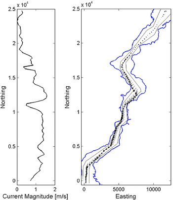
The surface current is an important parameter for the model since the distribution of the current distribution controls the position distribution of the vessel, and consequently the casualty probabilities. In this study, the currents measured by the Turkish Navy Department of Navigation, Hydrography and Oceanography is used. The data include point measurements along the Strait centre course (Figure 12). The directions of the currents are assumed to be fixed in time and the magnitudes are assumed to have a normal distribution around the measured value. The range of the variation is set to be 40% around the mean value that is found from the Istanbul Rail/Tunnel Consultants Consortium's hydrographic survey (1987).
Illustration of the current data used in the study (Turkish Navy Department of Navigation, Hydrography and Oceanography, 2002).

6.1.1. Grounding Avoidance
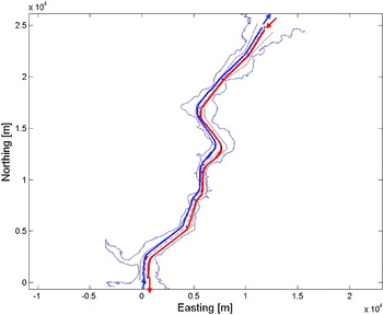
For grounding avoidance testing, both TSS restricted and unrestricted scenarios are used. Southbound and northbound vessels are simulated from entrance to exit with different initial positions. The main problem turns out to be the number and magnitude of heading deviations to form the possible heading set. Small deviations work satisfactorily with northbound traffic however southbound traffic needs larger deviations for regions like the Cape of Yenikoy, which is the sharpest turn in the Strait. The reason why southbound vessels cannot make this turn is that the strong relative currents push the vessels ashore. After some trial and error, course deviations are set as [−15° −10° −5° 0° 5° 10° 15°] for both southbound and northbound vessels. Figure 13 shows the courses for both vessels passing the Strait by keeping the proposed heading provided by the model under the Left-side up scheme (which is the opposite of the present regulations).
Safe navigation with “Left-side up” TSS restriction.

6.1.2. Collision Avoidance
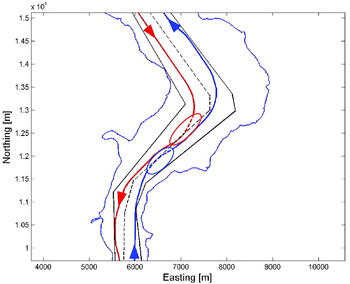
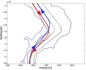
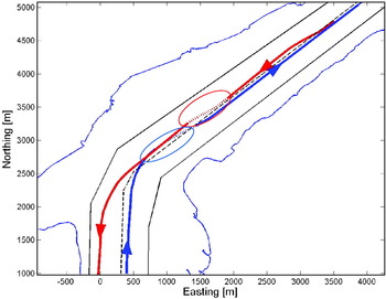
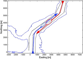
Figures 14–17 show two instances where two vessels meet at different points of the Strait. For both scenarios, the model is tested with and without TSS lane restrictions. For the no TSS restriction case, the penalty for TSS violations is removed. In Figures 14–17, the dashed lines (also circled) represent the routes taken when the Collision Combined algorithm is employed. From Figure 14 it can be seen that the northbound vessel cannot make the Cape of Yenikoy turn in the assigned TSS lane even when it is enforced by the model. If the unrestricted case is examined (Figure 15), it can be seen that the northbound vessel keeps to the right lane (TSS assigned lane) although there is no penalty assigned in the simulation for keeping to the left lane. This is because the previous bend in the Strait is a curve bending left, thus after the turn, the vessel ends up in right lane by keeping the proposed safe heading. Then, since the grounding algorithm does not favour course alterations, the vessel does not change its heading, keeps the channel alignment and stays in its lane. In Figures 16 and 17 navigation at a section closer to the south exit is illustrated. In Figure 17, although there is no TSS restriction, both vessels manoeuvre to the TSS lanes to avoid close encounter. Also, both vessels follow the trajectory in which the distance between the vessels is increased. As shown in Figure 16 with TSS restrictions, the northbound vessel makes a manoeuvre both to get back into the assigned lane and avoid collision at the same time. On the other hand, the southbound vessel recovers from a lane violation before meeting the northbound vessel but still makes a starboard manoeuvre to provide more space for the northbound vessel to manoeuvre and avoid a close encounter. No general inference can be reached for the necessity of TSS restriction itself from the results of only one possible instant. The analysis of policies such as TSS is given in the next section.
Collision avoidance scenario with TSS restriction.

Collision avoidance scenario without TSS restriction.

Collision avoidance scenario with TSS restriction.

Collision avoidance scenario without TSS restriction.

Danger scale for the passage for different simulations.

6.2. Policy Analysis
In this section, instead of analyzing separate navigation instances, a complete passage of two vessels sailing in opposite directions is considered. Two measures are tested to assess the navigational difficulty in the channel and the effect of legal policies on navigation.
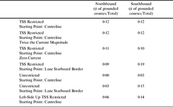
One measure is the number of the trajectories in the simulated trajectory tree which lead to grounding. A severe weather condition or a technical malfunction causes higher casualty risks if the neighbouring possible trajectories tend to ground more. Hence, this kind of a scale can give a quantitative measure about the potential danger of the proposed course. To have a scale between 0 and 1, the numbers were normalized with the number of trajectories per simulation. The scenarios and resulting Danger Scale for the Passage (DSP) are presented in Table 1.
In all scenarios, southbound navigation is more prone to cause an accident. This can also be verified from the simulations where a small number of heading deviations from the Strait centreline is sufficient for northbound vessels whereas more projected trajectories covering a wider range of headings are necessary for southbound vessels. Another result is that the TSS restrictions seem to increase the grounding probability, however, this is not literally correct since all the TSS violations are also recorded as grounding probabilities. It turns out that when the way of navigation is switched, e.g. left-side up, the DSP number for the northbound vessels decreases by one half, whereas it increases by nearly 20% for southbound vessels. It is also shown that the vessels entering the Strait near the centreline, ground less – which is intuitive. The measured currents are mostly parallel to the centreline thus no large side-sway forces are imposed on the vessel. Some exceptions occur near the sharp bends in the Strait, such as the Yenikoy Bay in the previous example, where the grounding probability increases because the orientation of currents starts drifting the vessels ashore.
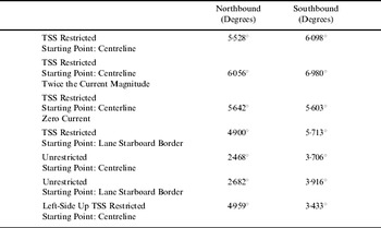
Another parameter is introduced is the Average Deviation from the Central Path (ADCP) scale. In this study, navigating with the channel alignment angle is assumed to be the safest. This parameter tracks the proposed route and measures its deviation from the channel alignment angle. The standard deviation of the difference between the proposed heading angles and the channel alignment is calculated to find the ADCP. In Table 2, the ADCP values are presented for different case studies.
Average deviation from the central path (ADCP) for different case studies.

The ADCP scale, unlike the DSP, allows comparisons between the TSS restricted and unrestricted scenarios. The results show that it is easier (without large deviations from the channel alignment) to navigate near the channel centreline without TSS regulations. However, an interesting outcome is observed for the left-side-up TSS restriction. Like DSP, both for northbound and southbound vessels, smoothness decreases when the left-side-up scheme is employed. Just as in DSP, currents do not affect as much because the surface current orientation is mostly parallel or close to the centreline alignment.
7. CONCLUSIONS AND REMARKS
This study proposes a model that can be used as a real time decision support system tool for navigation in narrow channels. A hydrodynamic ship model with reasonable runtime is used and the model is applicable to any narrow channel with a system providing the necessary input. The proposed navigation support model can be used in a management centre and dynamically provides the safest heading values during navigation, considering the vessel position and drift forces due to surface currents. A possible system for such a model to be implemented could be VTS, with some improvements on data gathering about vessels' navigation parameters which could be achieved by using advanced maritime tracking systems such as AIS. The study presents interesting results regarding different possible TSS schemes in the Strait of Istanbul. Please note that the analysis of these navigation schemes are performed to present the model's applicability to different policy environments rather than challenging the existing rules. Nevertheless, the results obtained show promising results in terms of replicating the expert knowledge as explained below.
First, an interesting finding of the study is that the southbound vessels carry more casualty risk than the northbound vessels. This statement agrees with Özkan (Reference Özkan2003) who found the same result. Another finding is that the left-side-up traffic flow is less dangerous compared to the currently employed right-side-up scheme. The left-side-up scheme was employed until 1982, and vessels used to switch from right-side-up (which is the international scheme for open waters) to left-side-up while entering the Strait (and the opposite while exiting). However, this simultaneous switch from both directions resulted in casualties, the biggest one being the Independenta tanker accident in 1982, which eventually lead to change to a right-hand-side scheme in the Strait. However, left-side-up is suggested by experienced captains for navigation inside the Strait. This study reinforces the experienced expertise knowledge with a mathematical model. Here, it should be noted that our model considers the traffic in the Strait of Istanbul only, and not the entire navigation route (the Turkish Straits) which also includes the Marmara Sea. Therefore, the risk due to the entrance and exit manoeuvres may affect the overall risk. The question of which scheme is theoretically the safer one can only be answered with a model covering the entire system of the Turkish Straits.
Another point is that the southbound vessels mostly carry oil and hazardous materials coming from the Black Sea where the northbound vessels mostly travel with less dangerous cargo or empty. This makes it hard to make conclusions about the right scheme to be employed in the Strait of Istanbul since the danger scale for the passage tends to rise for southbound vessels for left-side-up traffic. Briefly, it can be concluded that left-side-up traffic is more convenient for the Strait, but only inside the Strait if the type of the cargo carried is not considered.
The overall results can be summarized as follows:
• For all the test runs, the model was able to provide a navigation guidance for safe passage,
• The TSS restrictions increase the navigation difficulty for Strait of Istanbul,
• The closer the entrance point of the vessel to the channel centreline, the safer and smoother is the navigation,
• Southbound travel is more dangerous in terms of navigational difficulty in the Strait of Istanbul.
• Left-side-up traffic is less dangerous in terms of casualty risk compared to the currently enforced right-side-up traffic only in the Strait of Istanbul.
The model structure is flexible for upgrading and can be used for other narrow channels with different physical and hydrodynamic conditions. For instance, the program can call different hydrodynamic vessel models according to the information coming from VTS operators or other sources that can disseminate the vessel type information (such as AIS). The auto-pilot constants can be adjusted to model different pilots and relevant pilot profiles can be used by the model depending on the experience of the pilot. Likewise, the detailed surface currents can be incorporated into the model easily. Although the model is based on two vessels at a time, its generalization to the entire channel traffic is feasible. The underlying logic of the model is to predict possible trajectories of the navigating vessels, and there is no barrier to simultaneously running the model for multiple vessels. The two vessel model can be run in a reasonable time interval since the runtime provided by the hydrodynamic model is less than the actual navigation time for the proposed routes. Although the liability and legal aspects of the problems introduce barriers on immediate use, the proposed model provides a basis for further development of a narrow channel navigation guidance system.
ACKNOWLEDGMENTS
The authors would like to thank to Dr. Özkan Poyraz (Director General, Maritime Directorate, Turkish Ministry of Transport) for providing practical insights and for his valuable comments during this research. We also would like to thank Eng. Lieutenant Mustafa ÖzyalvaÁ (Turkish Navy Department of Navigation, Hydrography and Oceanography) for his help in obtaining the Bosporus current measurements used in this study.