

The Yishu fault zone is a major tectonic structure in eastern China, situated along the convergent boundary between the North China Craton and the Yangtze Block. Owing to its large-scale, deep crustal penetration, extensive spatial extent and prolonged tectonic activity, it is recognized as one of the most important active fault systems in the region (Yang et al., Reference Yang, Yang and Li2008; Dong et al., Reference Dong, Li, Chen and Zhao2009; Cai & Zhong, Reference Cai and Zhong2015; Qiao et al., Reference Qiao, Liu and Gao2022). The evolutionary process of this fault zone has exerted fundamental control over regional geological processes and has strongly influenced the distribution and development of geothermal resources in the area. Intense hydrothermal activity is widely developed along the Yishu fault zone, with surface temperature anomalies concentrated in specific areas such as the Yinan, Tongjing and Tangtou geothermal fields. These hydrothermal manifestations reflect the upward migration of deep heat flow along fault structures and provide important geological evidence for geothermal resource exploration. Therefore, investigating the geothermal system associated with the Yishu fault zone is not only of theoretical significance for understanding the tectonic evolution of eastern China, but also of practical value for guiding the exploration and development of geothermal resources.
Long-term tectonic deformation and continuous hydrothermal circulation have led to the extensive hydrothermal alteration of the rocks adjacent to the fault zone, making hydrothermal alteration a key geological indicator of geothermal activity. This process typically generates abundant clay minerals, including sericite, montmorillonite and chlorite, whose assemblages exhibit systematic zonal characteristics controlled by factors such as temperature, fluid composition, host rock lithology, permeability and alteration duration. In neutral-pH geothermal systems, low-temperature conditions (100–150°C) are typically characterized by smectite (e.g. montmorillonite) and zeolites; intermediate temperatures (170–250°C) favour the formation of illite–smectite mixed layers (which gradually transform into illite) along with chlorite and adularia; and high-temperature environments (250–340°C) may contain epidote, biotite, actinolite and other amphiboles in association with illite, chlorite and adularia (Browne, Reference Browne1978; Henley & Ellis, Reference Henley and Ellis1983; Reyes, Reference Reyes1990). Accordingly, clay mineral assemblages can serve as effective proxies for evaluating geothermal activity and estimating subsurface temperature conditions.
Conventional identification of hydrothermal alteration minerals in geothermal fields mainly relies on petrographic microscopy, scanning electron microscopy and X-ray diffraction analysis of drill cuttings (Kraal et al., Reference Kraal, Ayling, DeOreo and Calvin2024). Although these methods yield high accuracy, they are labour-intensive and spatially limited, making them unsuitable for the rapid and large-scale characterization of clay mineral distributions along extensive fault zones. Hyperspectral remote sensing features high spectral resolution with a narrow bandwidth of ∼5–20 nm, which enables the detection of subtle spectral characteristics diagnostic of various clay minerals and provides an efficient approach for regional-scale mapping of hydrothermal alteration zones (Kokaly et al., Reference Kokaly, Swayze, Livo, Hoefen, Hubbard and Meyer2021). Compared with traditional field investigations, hyperspectral remote sensing techniques have obvious advantages in terms of spatial coverage, data acquisition efficiency and repeatability, especially in tectonically complex and inaccessible terrains (Meyer et al., Reference Meyer, Kokaly and Holley2022). While hyperspectral data have been successfully applied to mineral mapping and resource exploration worldwide (Hecker et al., Reference Hecker, van Ruitenbeek F.J.A., van der Werff, Bakker, R.D. and van der Meer2019; Liu et al., Reference Liu, Yin, Shaheen, Hong, Feng and Zhang2024), systematic studies on the hyperspectral characteristics of clay minerals and their correlation with geothermal resources in the Yishu fault zone remain scarce.
In this study, the Yishu fault zone was selected as the research area to investigate the hyperspectral remote sensing characteristics of representative clay minerals using ZY1-02D hyperspectral imagery. Principal component analysis (PCA) and the Crósta method were adopted for spectral processing to extract the spatial distribution of clay minerals. In addition, ZY1-02E thermal infrared data were used to retrieve the land surface temperature (LST). By integrating the spatial patterns of clay minerals, the intensity of hydrothermal alteration and surface temperature anomalies, this study aims to evaluate the indicative significance of the hyperspectral characteristics of clay minerals for geothermal resource exploration, as well as to provide a scientific basis for precise geothermal prospecting and sustainable development in the Yishu fault zone.
Study area
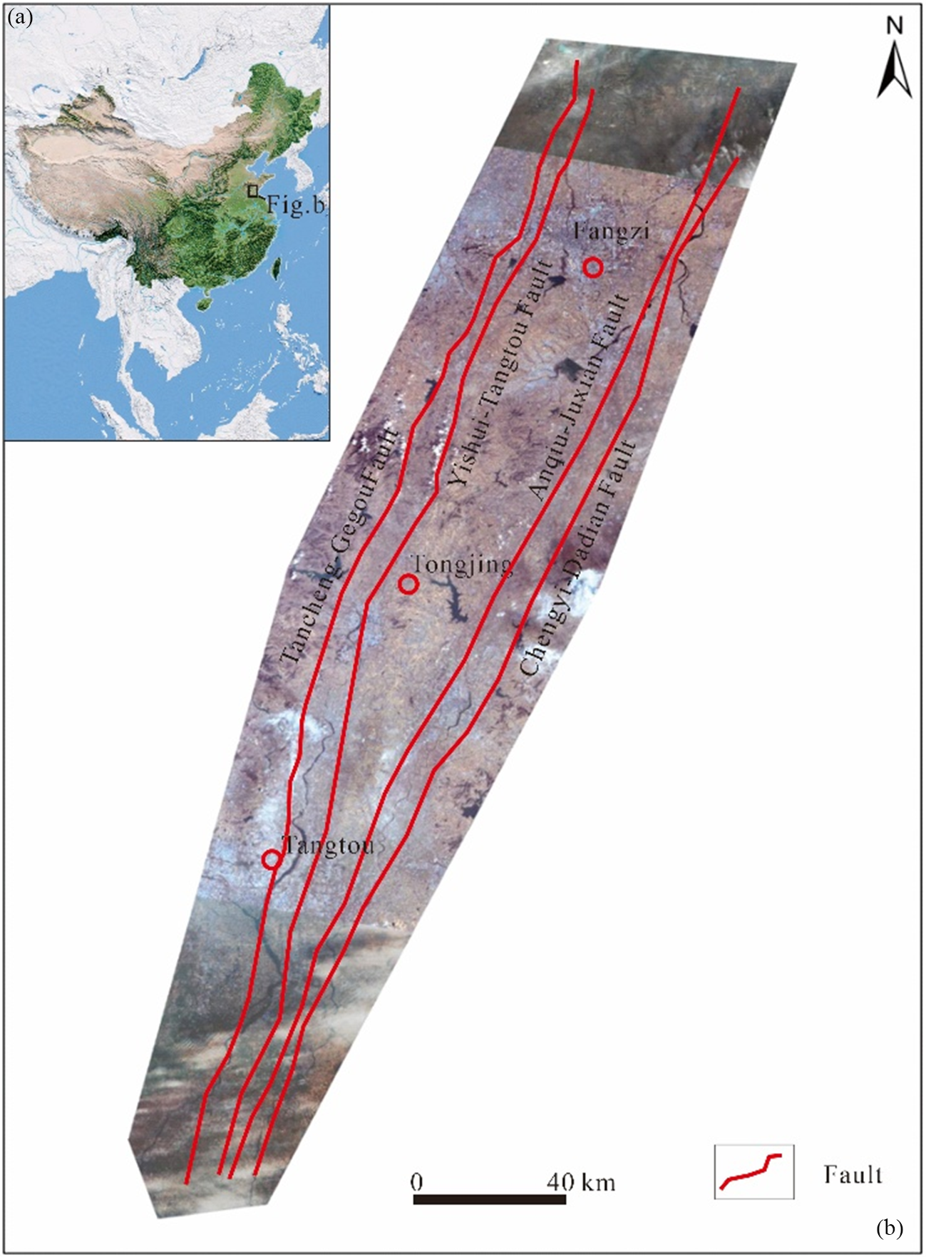
The Yishu fault zone investigated in this study is located between 118°05′00″E and 119°40′00″E and between 34°22′00″N and 37°11′00″N, covering an area of ∼17,180 km2. Three representative subareas were selected as key research sites: (1) the eastern Fangzi Sag in the northern segment of the fault zone (695 km2); (2) the Tongjing geothermal field in the Yinan area within the central segment (644 km2); and (3) the Tangtou geothermal field in the southern segment (460 km2; Fig. 1). The study area lies at the tectonic junction between the North China Craton and the Yangtze Block, a setting that exerts strong control over regional structural development and geothermal activity (Wang et al., Reference Wang and Wang2012).
Location of the study area. (a) Location map of the study area in China. (b) Simplified fault map of the study area showing major faults locations.

The Yishu fault zone is a large-scale and long-lived tectonic system with deep crustal penetration and a complex structural framework. It consists of four major fault belts: the Changyi–Dadian fault, the Anqiu–Juxian fault, the Yishui–Tangtou fault and the Tancheng–Gegou fault. These faults together form a composite graben structure characterized as ‘two grabens and one horst’, including the eastern Anqiu–Juxian graben, the western Mazhan–Sucun graben and the intervening Gongdanshan uplift (Wang et al., Reference Wang, Zheng, Liu, Xu and Li2015). The faults are mainly orientated in nearly east–west (75–105°), north-east (15–75°) and north-west (290–330°) directions, forming a dense and intersecting fracture network.
The strata in the study area range from the Archaean to the Quaternary. The core of the fault zone is mainly composed of Precambrian metamorphic rocks such as gneiss, schist and mylonite, whereas the surrounding areas are dominated by Palaeozoic to Mesozoic sedimentary rocks (sandstone, shale and limestone) and volcanic rocks including basalt and andesite. The area has experienced multiple phases of tectonic deformation, accompanied by episodic magmatism and hydrothermal fluid circulation. Prolonged fault activity has generated abundant fractures and pore spaces, which serve as effective pathways and reservoirs for the migration and accumulation of geothermal fluids (Li et al., Reference Li, Zhuo, Geng and Liang2017).
Datasets and methods
Datasets
ZY1-02D hyperspectral data
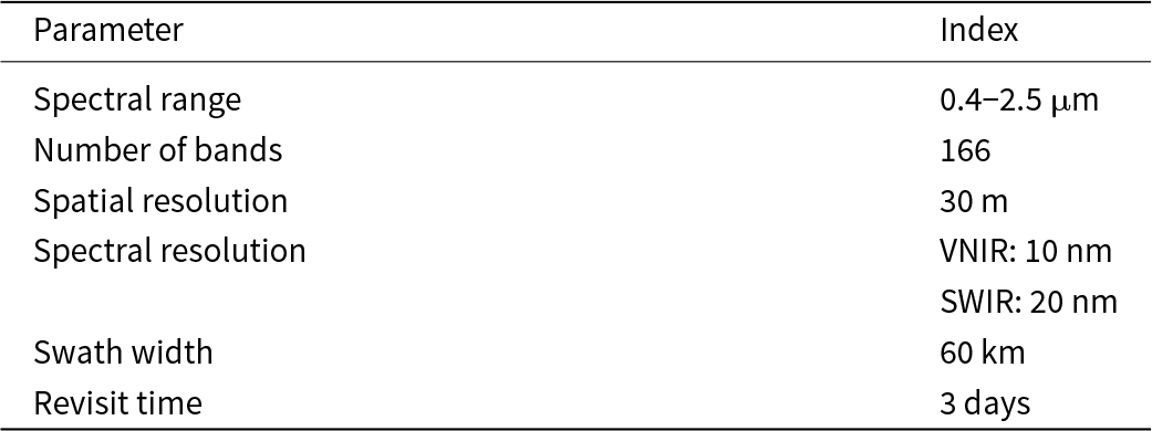
The ZY1-02D satellite, launched on 12 September 2019, is equipped with a hyperspectral imager covering a spectral range of 0.4–2.5 μm with 166 contiguous bands. The spectral resolution is ∼10 nm in the visible–near-infrared (VNIR) region and 20 nm in the shortwave infrared (SWIR) region, and the spatial resolution is 30 m (Table 1). The hyperspectral dataset used in this study provides full coverage of the Yishu fault zone. Image acquisition dates were selected to minimize cloud cover and ensure relatively stable atmospheric conditions, thereby improving data quality for spectral analysis.
Key parameters of the ZY1-02D hyperspectral sensor.

ZY1-02E thermal infrared data
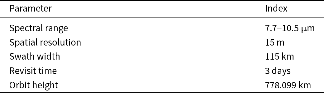
The ZY1-02E satellite, launched in December 2021, is equipped with a long-wave thermal infrared sensor operating in the 7.7–10.5 μm spectral range, with a spatial resolution of 15 m and a swath width of 115 km (Table 2). In this study, the thermal infrared data were used to retrieve the LST, providing essential information for examining the spatial relationship between clay mineral distributions and geothermal anomalies.
Key parameters of the ZY1-02E long-wave infrared sensor.

Auxiliary data
Auxiliary datasets used in this study include 1:50,000 topographic maps, regional geological maps, field survey data from known geothermal fields and reference spectra of clay minerals obtained from the Advanced Spaceborne Thermal Emission and Reflection Radiometer (ASTER) spectral library. These datasets were employed for geometric correction of remote sensing imagery, validation of clay mineral extraction results and interpretation of the regional geological framework.
Data preprocessing
Preprocessing of the ZY1-02D hyperspectral data
Preprocessing of the ZY1-02D hyperspectral imagery involved several standard steps. First, radiometric calibration was applied to convert the original digital numbers (DNs) to radiance using sensor calibration coefficients, thereby correcting for sensor response effects. Second, atmospheric correction was performed using the Moderate Resolution Atmospheric Transmission (MODTRAN) model to remove atmospheric scattering and absorption and to retrieve surface reflectance. Third, geometric correction was conducted based on 1:50,000 topographic maps by selecting ground control points, with the geometric accuracy controlled to within one pixel. Fourth, the corrected images were mosaicked and clipped according to the extent of the study area and the selected key subareas. Finally, image enhancement techniques, including false-colour composites, PCA and band ratio transformations, were applied to emphasize clay mineral spectral features and improve the signal-to-noise ratio.
Preprocessing of the ZY1-02E thermal infrared data
Preprocessing of the ZY1-02E thermal infrared imagery included radiometric and geometric corrections. Radiometric correction was applied to convert DNs to brightness temperature using sensor calibration parameters. Geometric correction was performed using the same reference framework as the hyperspectral data to ensure spatial consistency among the multi-source datasets.
Research methods
Spectral characteristic analysis of clay minerals
Based on reference spectra from the ASTER spectral library and field-collected clay mineral samples, the spectral characteristics of representative clay minerals (illite, montmorillonite and chlorite) in the study area were analysed. Emphasis was placed on identifying diagnostic absorption features, including the position, depth and width of characteristic absorption bands, to establish a spectral basis for clay mineral extraction from hyperspectral imagery.
Extraction of clay mineral information based on hyperspectral data
Based on the spectral characteristics of clay minerals, two complementary methods – PCA and the Crósta technique – were used to extract clay mineral information from the hyperspectral data. First, PCA was applied to the full hyperspectral dataset to concentrate the spectral information related to clay minerals in higher-order principal components while suppressing background and noise signals, thereby facilitating clay mineral mapping. Second, the Crósta method was implemented by performing PCA on selected diagnostic bands associated with clay minerals (especially those related to hydroxyl absorption features) to enhance the spectral contrast between clay minerals and other surface materials and to improve the extraction accuracy.
Prior to mineral extraction, vegetation and water bodies were removed by applying vegetation and water masks, thereby minimizing the influence of non-target features on the clay mineral mapping results.
Surface temperature inversion
LST was retrieved from the ZY1-02E thermal infrared data using the single-window algorithm. The main procedures included the following steps: first, surface emissivity was estimated using the Normalized Difference Vegetation Index (NDVI)-based approach, in which fractional vegetation cover was calculated and surface emissivity was derived by weighting the emissivities of vegetation, bare soil and water. Second, atmospheric parameters were obtained by inputting regional meteorological data, including water vapour content and atmospheric temperature, into the MODTRAN model to derive atmospheric transmittance and upwelling radiance. Finally, LST was calculated for each pixel by incorporating brightness temperature, surface emissivity and atmospheric parameters into the single-window algorithm.
Accuracy verification
The accuracy of the clay mineral extraction results was evaluated using two complementary approaches: field-based validation and multi-source data comparison. Representative sites were selected for field sampling, where clay mineral assemblages were identified through laboratory analyses and compared with the corresponding remote sensing-derived results. In addition, the extracted clay mineral distributions were compared with mapped hydrothermal alteration zones from existing geological maps to further assess the reliability of the extraction results.
Results
Spectral analysis
Clay minerals containing hydroxyl (OH–) and molecular water (H2O) are characterized by diagnostic absorption features primarily in the 2.2–2.3 μm wavelength range. As a result, OH–-bearing alteration minerals generally exhibit relatively low reflectance in Band B8 and higher reflectance in Band B6 of the ZY1-02D sensor. These spectral differences are expressed as variations in greyscale values between adjacent bands, allowing OH–-bearing altered minerals to be distinguished. In addition, absorption features near 1.4 and 1.9 μm provide further criteria for confirming the presence of OH–-related absorption.
Based on the spectral characteristics of OH–-bearing alteration minerals in the study area and the band-selection principles of the Crósta method, Bands B1, B3, B4 and B8 of the ASTER sensor were selected for OH– alteration anomaly extraction. Among these bands, Band B4 corresponds to a relatively reflective spectral region, whereas Band B8 is associated with strong absorption. When included in the PCA, these bands are expected to exhibit opposite loadings, enhancing the contrast of OH–-bearing alteration signals. For the ZY1-02D imagery, the spectral interval of 1.560–1.651 μm represents a reflective region for OH⁻-bearing minerals, whereas the 0.500–0.680 μm range corresponds to strong absorption. Accordingly, four bands covering the wavelength ranges of 0.450–0.515, 0.845–0.885, 1.560–1.651 and 0.500–0.680 μm were selected for OH– alteration extraction using the Crósta approach. Characteristic eigenvector matrices for both ASTER and ZY1-02D datasets were calculated using standard remote sensing software, and the results are summarized in Tables 3 & 4.
Eigenvectors for the ASTER PCA.

PC = principal component.
Eigenvectors for the ZY1-02D PCA.

PC = principal component.
Hyperspectral characteristics of clay minerals
Diagnostic spectral features
OH– groups in the Yishu fault zone display distinct diagnostic absorption features in the SWIR region, which are closely associated with clay minerals formed through hydrothermal alteration. Analysis of the ZY1-02D hyperspectral data indicates that prominent absorption features are concentrated near 1.4, 1.9 and 2.2 μm. The absorption bands at ∼1.4 and 1.9 μm are attributed to O–H stretching vibrations and combined stretching–bending vibrations in hydrated minerals such as montmorillonite, illite and chlorite. The absorption feature near 2.2 μm corresponds to Al–OH bonds and represents a key diagnostic indicator of hydrothermally altered clay minerals, particularly illite and chlorite.
Compared with weakly altered zones, areas affected by intense hydrothermal alteration exhibit significantly greater absorption depths at 1.4 and 2.2 μm, with spectral contrast values exceeding 0.3 in the key study areas. This enhanced absorption response highlights the effectiveness of SWIR spectral features for identifying OH–-bearing clay minerals and delineating hydrothermal alteration intensity.
Spatial distribution patterns
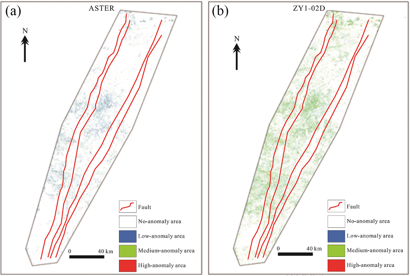
The spatial distribution of clay mineral anomalies is strongly controlled by tectonic structures and exhibits a clear zonal pattern aligned with the dominant fault orientations. At the regional scale (17,180 km2), clay mineral anomalies are predominantly distributed along the four major fault zones and their intersections, forming continuous, linear to belt-like patterns. Medium- to low-intensity anomalies constitute ∼78% of the total anomalous area and are characterized by broad and laterally continuous distributions (Fig. 2).
Clay mineral anomaly information extraction map from (a) ASTER and (b) ZY1-02D.

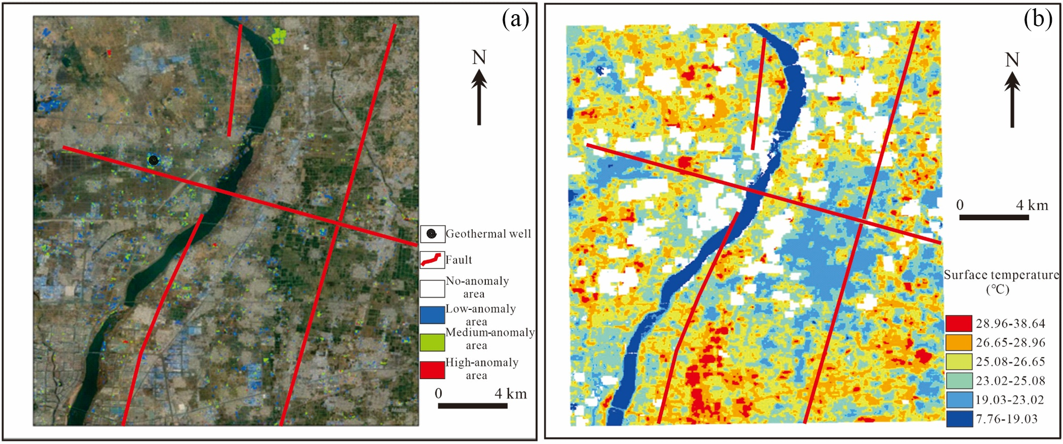
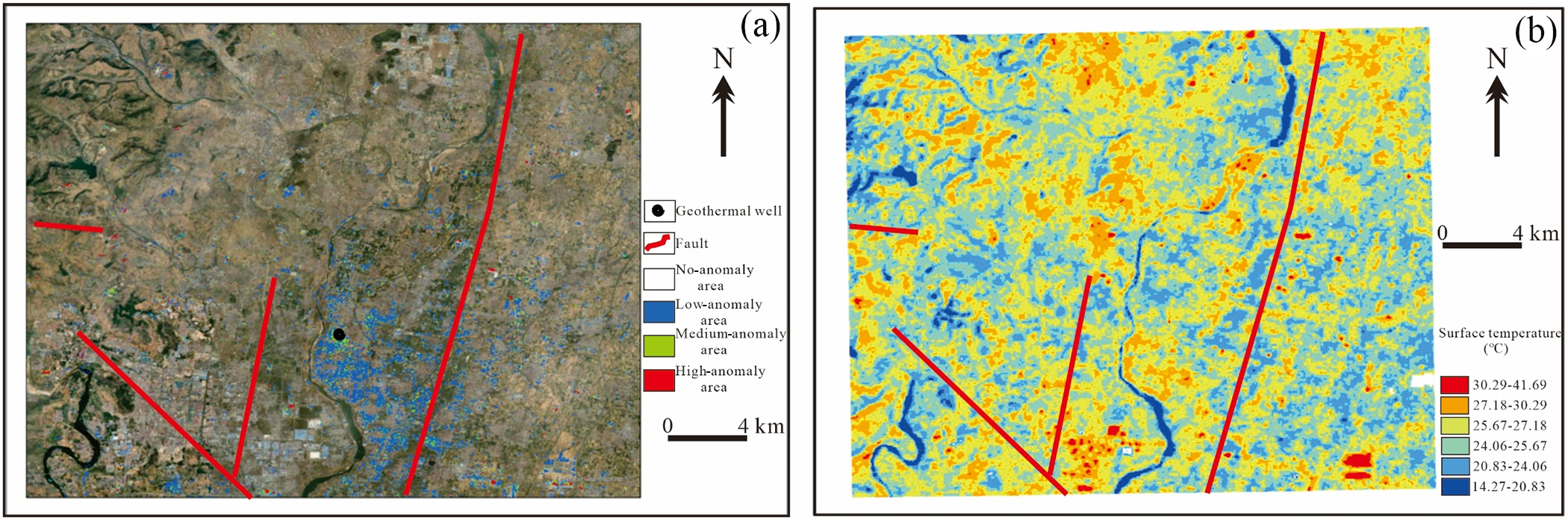
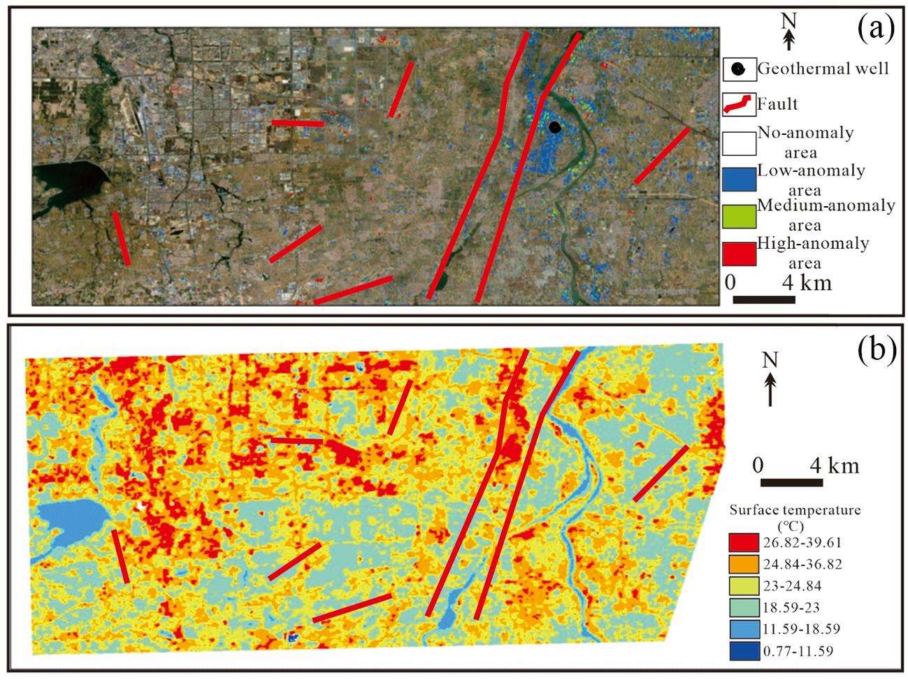
High-intensity anomalies are spatially restricted and mainly concentrated near fault intersections and river valleys, with individual anomaly patches typically ranging from 0.3 to 0.8 km2 in area. In the key study areas, distinct spatial variations are observed. In the Tangtou area, low-intensity anomalies are widely distributed, whereas medium- to high-intensity anomalies occur locally and are preferentially developed near river systems (Fig. 3a). The Tongjing area is characterized by concentrated clay mineral anomalies along the eastern bank of the southern river segment (Fig. 4a). In contrast, the Fangzi area exhibits pronounced clay mineral anomalies in its northern part, which are closely associated with localized tectonic activity (Fig. 5a).
(a) Clay mineral extraction results for the Tangtou area based on ZY1-02D satellite data and (b) LST inversion results for the Tangtou area based on ZY1-02E satellite data.

(a) Clay mineral extraction results for the Tongjing area based on ZY1-02D satellite data and (b) LST inversion results for the Tongjing area based on ZY1-02E satellite data.

(a) Clay mineral extraction results for the Fangzi area based on ZY1-02D satellite data and (b) LST inversion results for the Fangzi area based on ZY1-02E satellite data.

Discussion
Hyperspectral signatures of clay minerals for hydrothermal alteration
The hyperspectral characteristics of clay minerals in the Yishu fault zone are primarily governed by their chemical composition and crystal structure. OH– groups are the principal contributors to the diagnostic absorption features, whereas the type and abundance of metal cations (e.g. Al3+, Fe2+ and Mg2+) within the crystal lattice control the position and intensity of the absorption bands (Clark et al., Reference Clark, King, Klejwa, Swayze and Vergo1990). Illite, which is enriched in Al3+, exhibits a pronounced absorption feature near 2.2 μm associated with Al–OH bonds. Montmorillonite is characterized by a high structural water content, resulting in broad and deep absorption features near 1.4 μm. In contrast, chlorite contains significant Fe2+ and Mg2+, producing characteristic absorption bands near 2.25 μm (Fe–OH) and 2.34 μm (Mg–OH).
The clay mineral assemblages in the study area are the products of hydrothermal alteration driven by deep geothermal fluids. These fluids transport heat and reactive components upward along fault-controlled pathways and interact with surrounding rocks, such as feldspar- and amphibole-bearing lithologies, through hydrolysis and metasomatic reactions, leading to clay mineral formation (Sillitoe, Reference Sillitoe2010). Variations in hydrothermal intensity exert strong control over clay mineral assemblages: intense hydrothermal activity favours the development of OH–-rich minerals such as montmorillonite and sericite, whereas weaker alteration conditions are dominated by chlorite. Consequently, the hyperspectral signatures of clay minerals provide an effective proxy for assessing both the intensity and spatial extent of hydrothermal activity in the Yishu fault zone.
Indicative significance of clay minerals for geothermal resources
The spatial distribution of clay minerals in the Yishu fault zone is closely controlled by fault structures, with high clay mineral concentrations preferentially developed along major faults and their intersection zones (Figs 2, 3a, 4a & 5a). Faults act as primary conduits for the ascent and lateral migration of geothermal fluids. The upward flow of these fluids promotes intense water–rock interactions in adjacent host rocks, leading to hydrothermal alteration and the formation of clay minerals (Cooke et al., Reference Cooke, Agnew, Hollings, Baker, Chang and Wilkinson2020). Consequently, the linear and belt-like distributions of clay minerals can be regarded as effective indicators of geothermal fluid migration pathways.
Spatial correlation analysis further reveals a strong overlap between clay mineral-rich zones and surface temperature anomalies (Figs 3b, 4b & 5b). This relationship reflects the accumulation of geothermal fluids in shallow reservoirs along fault-controlled pathways, where prolonged fluid–rock interaction facilitates extensive clay mineral development (Neal et al., Reference Neal, Wilkinson, Mason and Chang2018). In addition, clay minerals commonly exhibit low thermal conductivity, which may reduce heat dissipation and enhance heat retention within geothermal reservoirs. Therefore, zones characterized by intense clay mineral alteration represent favourable targets for geothermal reservoir development.
Advantages and limitations of hyperspectral remote sensing in geothermal resource exploration
Compared with conventional geological survey approaches, hyperspectral remote sensing offers clear advantages for geothermal resource exploration in the Yishu fault zone. It enables the rapid, large-scale identification of clay minerals and efficient extraction of hydrothermal alteration information, facilitating the preliminary screening of prospective geothermal targets. Moreover, the availability of multi-temporal hyperspectral data allows for the monitoring of variations in hydrothermal activity, providing valuable support for the sustainable development and management of geothermal resources.
Nevertheless, several limitations should be recognized. Clay mineral extraction can be affected by vegetation cover and anthropogenic disturbances, leading to reduced accuracy in densely vegetated areas. Future studies may benefit from the integration of higher-spatial-resolution hyperspectral datasets to improve mineral discrimination, as well as from the combined use of geophysical and geochemical data to establish a more comprehensive geothermal exploration framework.
Conclusions
1) The typical clay minerals in the Yishu fault zone, including illite, montmorillonite and chlorite, exhibit distinct diagnostic hyperspectral features that serve as effective indicators of hydrothermal activity and geothermal potential. OH–-related absorption features are concentrated near 1.4, 1.9 and 2.2 μm, where the 1.4 and 1.9 μm bands are associated with O–H stretching and combined stretching–bending vibrations in hydrated minerals and the 2.2 μm band corresponds to Al–OH bonds in hydrothermally altered minerals. These spectral characteristics provide a robust basis for the hyperspectral identification and mapping of clay minerals.
2) The spatial distribution of clay minerals in the Yishu fault zone is strongly controlled by fault structures, with anomalies primarily developed along the four major fault zones and their intersections in linear to belt-like patterns. A clear positive spatial correlation exists between clay mineral abundance and surface temperature anomalies. Areas of intense hydrothermal alteration show strong spatial agreement with known geothermal fields and high-temperature zones, indicating that clay mineral distributions effectively delineate geothermal fluid migration pathways and favourable accumulation zones.
Acknowledgements
The authors thank the anonymous reviewers for their helpful reviews of the manuscript and the Principal Editor, Prof. Chun-Hui Zhou, for constructive suggestions and comments on this work.
Financial support
This work was supported by the Shandong Provincial Natural Science Foundation (Grant No. ZR2025MS686), the Shandong Provincial Geological Exploration Project (LKZ [2024] 73), the Geological Exploration Leading Demonstration and Scientific Research Project of Shandong Provincial Bureau of Geology & Mineral Resources (LDZ [2022] 15) and the Geological Exploration Project of Jinan Natural Resources and Planning Bureau (SDGP370100000202302000887).
Competing interests
The authors declare none.