
Introduction
The Ifugao agricultural terraces offer a means to better understand agricultural ecology and relationships between the landscape and human organisation. Similar to other agricultural systems in Southeast Asia, the complexity of Ifugao agriculture can be considered an ‘agro-cultural complex’.Footnote 1 The concurrent existence of intensive agriculture, swidden and agroforestry in the region provides an opportunity to look into a living agricultural system where components are interrelated and integrated into economic, political and religious spheres. Moreover, the Ifugao agricultural system presents a case study for addressing issues of economic and ecological sustainability of current farming systems, and the implications of state agricultural policies.
Using an historical ecological approach,Footnote 2 this article discusses the links between agricultural intensification and ecological and social factors. Dominant models on the intensification of agricultural production suggest an evolutionary relationship between extensive and intensive systems. Previous archaeological models for agricultural intensification assumed that there was a direct link between population and production systemFootnote 3 and levels or stages of change.Footnote 4 These models, however, focused on lowland (i.e. Egypt, Mesopotamia, China) or island populations (i.e. the Pacific), whose evolution suggests that population increase and ecological factors may have influenced production intensification, making swiddening and gardening less suitable. In highland Southeast Asia, however, the relationship between extensive and intensive systems differs. The simultaneous presence of both farming systems suggests that a risk-minimisation strategy is an important aspect of how populations choose a specific subsistence system. Thus, ethnographicFootnote 5 and archaeologicalFootnote 6 studies in montane Southeast Asia challenge dominant intensification models.
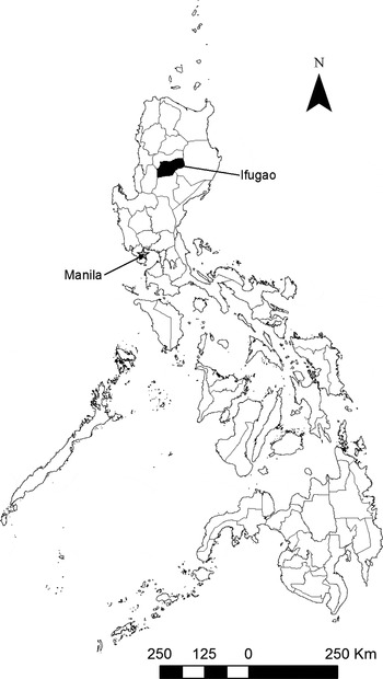
This work re-evaluates the existing models using ecological parameters, as exemplified by the distribution of agricultural fields in the North Central Cordillera in the Philippines (see Figure 1), a region famous for the Ifugao rice terraces. Statistical analysis was used to determine the relationship between the distribution of cultural features, in this case, terraced rice fields and swidden plots, with ecological parameters that include elevation, slope, aspect, distance to water source and distance to hamlets. The ecological–distributional relationships were then integrated with ethnographic and ethnohistoric data to establish the suite of ecological and social considerations that the Ifugao have in making decisions about their subsistence strategies.
Location map of Ifugao Province, Northern Philippines

In Ifugao, swiddening, intensive cultivation and agroforestry are part of a sustainable system. Swiddening has been blamed for upland deforestation and desertification elsewhere; however, the Ifugao agricultural system sustains significant forest cover in the upland terrain. I argue that populations practising a combination of swiddening and intensive forms of cultivation demonstrate a risk-minimisation strategy.
In discussing agrarian ecological issues, I start with a description of the distribution of agricultural systems in the North Central Cordillera relative to environmental parameters. The Ifugao agricultural system (especially, terraced rice pond-fields) is a unique opportunity for long-term study by archaeologists and ecologists; the terraces are still being used after more than four centuries.Footnote 7 As opposed to other agricultural systems of archaeological interest (i.e. Mimbres Valley, Mexico, the Andean raised fields, and Kohala field in Hawai'i), the Ifugao study provides us with both ethnographic and archaeological evidence for understanding human–environment interactions.
To balance the dataset (information obtained in the 1960s)Footnote 8 I focused on the present-day distribution of Ifugao agricultural systems. Where I use the term ‘traditional’, it refers to practices not influenced by the Green Revolution and its methods and that are ‘indigenous’ to the Ifugao, as explained by local farmers. Currently, a number of Ifugao farmers employ both traditional and modern methods (i.e. use of synthetic fertilisers, pesticides, and International Rice Research Institute [IRRI] rice varieties) of farming introduced after the 1960s.
The distribution of terraces and swidden fields in the Ifugao landscape shows that the difficult terrain of the North Central Cordillera did not prevent the cultivation of domesticated rice — a crop that is more adapted to levelled and well-watered areas. The existence of swiddening of non-rice crops in the Ifugao agricultural suite also shows exploitation of less productive (marginal) soils or locations. Therefore, the Ifugao provides another study where intensive and extensive production systems coexist, thus contesting the suggestion that swiddening is an inferior subsistence strategy; rather, it is a complementary system.
Agricultural strategies and land tenure
As a result of the American colonial government's successful ‘pacification’ of Cordillera cultural communities at the turn of the twentieth century, the Ifugao were drawn into the Philippine's market economy, increasing their need for monetary income. Thus, the Ifugao agricultural system experienced a transition from subsistence to simple commodity production after the 1930s.Footnote 9 Hence, where previously, agricultural products, especially rice, were solely for household consumption (including feasts), Ifugao agricultural products began to be sold. Small-scale agriculture and small animal husbandry are still dominant livelihood sources for most Ifugao, however.
After the Second World War, the growing need for monetary income compelled the Ifugao to begin to migrate to the lowlands and abroad in search of paid work. Remittances from Ifugao working abroad and in Philippine cities combined with the perception of farming as a low-status occupation greatly diminished the prestige of Ifugao farming technologies.Footnote 10 The past decade, however, has seen the re-emergence of an Ifugao identity in the midst of integration into wider Philippine society (and globalisation), with a revival of both tangible and intangible heritage. This is evident in the resurgent importance given to the terraces and rituals associated with Ifugao farming. Today, both intensive (irrigated terraces, cultivated with rice and vegetables) and extensive (swidden fields, cultivated with root crops) agriculture is practised. Arboriculture (with the introduction of mangos, avocados and coffee) and garden horticulture (vegetables) have also been added to the suite of Ifugao agricultural strategies.
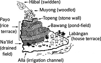
A cross-section of a typical area is presented in Figure 2, demonstrating some Ifugao agricultural strategies. Within a particular watershed, several types of land-use categories make up the agricultural system: two types of forest cover – ‘inalāhan (upslope public forests often composed of open-access communal areas) and muyong (privately owned woodlots managed with definite boundaries); hābal (swidden; unirrigated slopeland, cultivated with root crops, usually, sweet potatoes); labangan (house terraces; residential sites); na’īlid (drained fields; levelled terraced areas for cultivation and drainage of dry crops such as sweet potatoes and legumes); and payo (irrigated rice fields; levelled, terraced farmland, bunded to retain water).
Profile of an Ifugao terrace system. Stephen Acabado, ‘The archaeology of Ifugao agricultural terraces: Antiquity and social organization’ (Ph.D. diss, University of Hawai'i, 2010), p. 83

An important aspect of Ifugao agricultural terrace ecology and maintenance is the land-use category of muyong/pinugo, or privately owned woodlots. These woodlots serve as the watershed of a particular terrace system and are invaluable for terraces whose primary source of water are the springs located in these woodlots. Although hydrologic studiesFootnote 11 in the last three decades suggest that heavy forest cover actually results in more groundwater usage, these woodlots protect low-lying fields from runoff and erosion, and maintain the supply of surface and irrigation water (through cloud-intercept), stabilise relative humidity, and improve the soil's nutrients and physical and chemical properties.Footnote 12 Indeed, more logging in the vicinity of Banaue in the early 1980s accelerated runoff and evapotranspiration, exacerbating Ifugao's water shortages during the dry season.Footnote 13
The advent of a woodcarving industry in the Ifugao economy after the Second World War combined with the intervention of national forest conservation measures negatively affected the management of the muyong/pinugo system.Footnote 14 These carvings are sold locally, especially in the tourist town of Banaue. Although the carving industry itself was not a problem, national policies on logging disrupted the Ifugao forest management system. Previously, the Ifugao were able to access and obtain logs from their community's muyong/pinugo, while properly observing indigenous regulations on logging. The total log ban imposed by the national government, however, prevented them from accessing their wood supply. Since woodcarving had become a lucrative source of income for the Ifugao, the carving industry became an impetus for illegal, uncontrolled logging in the muyong/pinugo system, which has devastated some of the terrace systems in Ifugao.
Wet-rice cultivation
Anthropologists who have studied subsistence patterns in relation to social complexity have largely focused on intensive systems of cultivation.Footnote 15 The centralised management of large irrigation systems (and the intensification associated with these systems) has been seen as the stimulus for the emergence of social complexity. However, there are still a significant number of irrigation systems being run by local community organisations in Southeast Asia and very little attention has been paid to these systems.Footnote 16
In the Philippines, examples of these community-based irrigation systems are found in the densely populated lowland areas of Ilocos and the less densely populated province of Isabela that practise the zanjera system. Zanjera is a cooperative system of agricultural management developed in the north.Footnote 17 It involves the organisation of water allocation, maintenance of common agricultural structures (i.e. irrigation channels and ditches), as well as a conflict resolution system. In other words, a zanjera is a large, participatory and communal irrigation system without major state intervention. Currently, the National Irrigation Administration of the Philippines manages dams and water reservoirs; the zanjeras operate canals and local water distribution.
In the early 1970s Henry Lewis described the zanjera irrigation societies in the northern Philippine provinces of Ilocos and Isabela.Footnote 18 The zanjera system developed in Ilocos, historically a densely populated region. After the Second World War, the government sponsored migration to less densely populated areas in the country — similar to Indonesia's transmigrasi programme. Ilocano migrants who had been members of zanjeras settled in the province of Isabela, but did not form local zanjeras, which Lewis suggested was because of the different resource bases of the two provinces. Water was then readily available in Isabela (via the Cagayan River and its tributaries), and this, along with the lower population density, eliminated the need for community resource management. Rapid population growth in Isabela in the last four decades, however, has necessitated the establishment of irrigation cooperatives in the province, albeit under the direct supervision of the Department of Agriculture.
In Ifugao, there is no formal irrigation organisation such as the zanjera, although there is a customary cooperative system of reciprocal labour (uggbu or baddang). Cooperation among those whose fields have to share a water source — common in the area — is apparent. The need for this cooperation is emphasised in areas of intense population pressure or limited water supplies, or both, where the organisation of community labour and management is essential to gaining access to and sharing water, in order to minimise conflicts.Footnote 19 Similar to the zanjeras, the Ifugao study provides an illustration of a communal cooperative system, as necessitated by topographic/environmental limitations.
Intensification models
Agricultural intensification models are ultimately linked to demographic changes, although the nature of this causal relationship is debated (as in Boserup versus Malthus). The Boserupian linear model of intensification provided archaeologists (and anthropologists) with an empirical way of studying this process. In Boserupian terms, population growth forces the intensification of production via increasing capital inputs (labour, machinery, fertilisers).Footnote 20 Greater output (crop yields) is achieved through a linear progression of successive stages in the reduction of fallow length accompanied by progressive improvements in technology, the use of fertilisers, and a steady increase in labour inputs. This theory, however, fails to define ‘intensification’ clearly,Footnote 21 and the resulting models considered the relationship between simple subsistence strategy (swiddening) and intensive agricultural production (irrigated paddy fields) as evolutionary.
Similarly, Harold Brookfield's perspective on intensification rested on increases in labour inputs and other investments used to raise production significantly per unit of land or labour. His definition of intensification was tighter and shifted the focus away from levels or stages of intensity to the process itself. In Brookfield's view, ‘intensification of production describes the addition of inputs up to the economic margin, and is logically linked to the concept of efficiency through consideration of marginal and average productivity obtained by such additional inputs’.Footnote 22 In other words, there are a number of ways to increase productivity, but all of them involve additional inputs of time and energy. In foraging societies, an increase in gathering is almost synonymous to an increase in labour inputs per unit of land in food-producing societies, as well as an increase in the efficiency of production in craft-producing groups.Footnote 23 There are three significant aspects here: spatial, energy capitalisation, and technological. Examples of these are foragers who increase the spatial extent and duration of their food gathering; farmers who raise production by increasing labour input and the use of better technology; and specialists who develop more efficient equipment and skills.
Brookfield developed, with Piers Blaikie, the concept of landesque capital,Footnote 24 wherein labour inputs are focused on agricultural infrastructure (i.e. construction of terraces and irrigation channels), with the goal of making permanent modifications that will provide a long-term increase in production, while requiring minimal maintenance. Landesque capital also creates artificial microecosystems that are more efficient and suitable for longer and sustainable production.Footnote 25
Intensification then cannot be viewed through a single lens: its multidimensional character should serve to distinguish it from simple expansion or increase, and innovation.Footnote 26 In the archaeological concept of intensification, time is an inherent part of the process. Agricultural practices happen in a precise cycle within a given time-span. Thus, archaeologists can look at the long-term trends in strategies of intensification and view it as a process rather than as a series of single events. This implies multiple paths to intensification rather than a single route from long to short fallows.Footnote 27
The three perspectives discussed in this section point to labour as the major variable in agricultural intensification. As Vernon Scarborough noted, agricultural labour organisation probably led to greater social complexity.Footnote 28 Labour is difficult to archaeologically quantify compared with other aspects of technology, however. One way to shed some light on the historical role and impact of agricultural labour is the use of contemporary observations and landscape analysis and to compare them with archaeological information, given the antiquity of the terraces.
Water management systems and managerial requirements
The relationship between complex irrigation systems and social complexity has generated models of how anthropologists represent long-term culture change. Indeed, when Karl Wittfogel proposed the idea of ‘hydraulic civilisation’,Footnote 29 anthropologists were quick to apply his perspective to socio-organisational change, both in ancient and contemporary societies, but soon discovered that complex hydraulic systems do not necessarily lead to social complexity. Anthropologists generally agree that water systems of a certain scale entail some form of management, although the degree of organisational complexity varies.Footnote 30 The prevention of conflicts and disruption of societal dynamics is probably the most important task of water system organisation, but the degree of organisational complexity will determine how conflicts are resolved.
Water management systems develop from the interplay between the physical and cultural environments and emphasise cooperation. These result in the equitable sharing of water through a consensus often sanctioned by formality and law. As in religious systems, the more flexible and encompassing the rules of access and usage, the more lasting and resilient the water management system.Footnote 31 Stated differently, the systems with the best chance of uninterrupted longevity have slowly evolved on highly variable landscapes from which people make a living. Even under appreciable stress, water management systems tend to persevere because of their adaptability and dynamism. This dynamism can be seen in materially visible changes in settlement patterns and landscape transformation in the archaeological record over time.
Distribution of rice terraces in the North Central Cordillera of Luzon
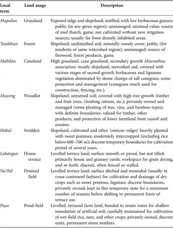
This section presents results of the Ifugao Geographic Information System (GIS) project, and reports the author's previous research.Footnote 32 It also illustrates the distribution of agricultural fields across the Ifugao landscape. A specific rice terrace or swidden field's location depends on ecological, social and cultural factors, including the knowledge of how these elements are interrelated and effectively utilised.Footnote 33 Present-day Ifugao terrace systems are a manifestation of these interrelated factors. They are also linked to land-use categories recognised by the Ifugao (Table 1).
Land use categories of the Ifugao

Source: Adapted from Harold C. Conklin, Pugguwon Lupaih, Miklos Pinther, and American Geographical Society of New York, Ethnographic atlas of the Ifugao: A study of environment, culture and society in Northern Luzon (London and New Haven: Yale University Press, 1980), pp. 7–8.
As mentioned, the Ifugao environment is generally considered marginal for intensive wet-rice systems. The region is located in the interior of the Cordillera mountain range, with a rugged topography. The average slope where irrigated pond-fields are located is 18°.Footnote 34 In contrast to lowland intensive systems located on gentler gradients, it is apparent that in Ifugao, wet-rice cultivation requires a high investment in energy and environmental modification.
Rice agricultural land use and the environment
The value of permanent agricultural property among the Ifugao, with rice fields as a primary example, rests on several factors other than the size or land area of the field.Footnote 35 These factors include: water sources; water loss (due to seepage, earthworms); distance from residence; immediate surroundings; shape of valley (e.g. deep concave); shape of bench-terraced surface; conditions of embankment (walling); quality of soil; type of fill; and protection from floods and avalanches.Footnote 36 Assuming that ethnographic models are a starting point for understanding long-term development of agricultural strategies and landscape use, spatial and ethnographic analysis provides us with information on landscape transformation and subsequent production intensification in the region.
The GIS database developed in this investigation includes distance from water sources and hamlets. In addition, several environmental factors were analysed to describe the distribution of rice terraces. These include elevation, slope and aspect.
Linking environmental characteristics to the distribution of the terraced fields in the Cordillera provides insights on optimal areas for agricultural production, based on the assumption that areas that were optimal for farming would have been the first to be exploited. Moreover, this section offers insights regarding factors that come into play in Ifugao decision-making about agricultural strategies.
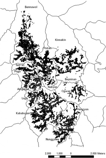
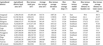
For this research, Harold Conklin'sFootnote 37 land-use maps of North Central Ifugao were digitised and incorporated in a GIS. Specific environmental parameters (elevation, slope, aspect, and distance to water and hamlet) were used to determine the range of environmental characteristics that the Ifugao use in deciding where to construct agricultural terraces. Table 2 summarises terrace feature for 13 agricultural districts (see also Figure 3).
Distribution of rice terraces and swidden fields across the 13 agricultural districts of North Central Cordillera

Summary of terrace features from individual agricultural districts

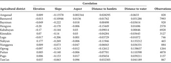
It is apparent that environmental parameters play a significant part in the Ifugao's choice of terrain to be cultivated. Statistical analysesFootnote 38 suggest that the environment directly influences the size of each individual rice terrace in Ifugao (P valueFootnote 39). However, the strength of the relationship (coefficient of determination or R-squaredFootnote 40) is not strong enough, suggesting that there are other aspects acting on the distribution (Table 3).Footnote 41 These aspects include social and cultural factors that are not readily available on two-dimensional land-use maps.
Correlation matrix between land area of individual rice terrace and elevation, slope, aspect, distance to hamlets, and distance to water source in each agricultural district

Through the course of the author's fieldwork in Ifugao, the research informants mentioned availability of labour sources, proximity to kin hamlets (which is directly related to the former), and stories of ancestral and other spirits in the area (which would require special rituals to appease the spirits and, thus, would be more expensive) as examples of social and cultural considerations in selecting a field for terrace construction. The author, while understanding that these are present-day decisions, finds these useful for this study, with the assumption that ethnographic data inform the past.
Distribution of rice terraces
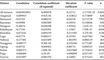
The average elevation of the rice fields or terraces in North Central Ifugao is 1,049 metres above sea level. However, the frequency distribution of the elevation of the rice fields was between 720–1515 metres above sea level, with 860 metres above sea level as the mode. Conklin et al. list the highest terraces as being 1600 metres above sea level.Footnote 42Table 4 illustrates an inverse relationship between the sizes of individual terraces relative to elevation for most of the agricultural districts investigated. However, linear regression results indicate that elevation hardly affects the distribution of the terraces.
Results of linear regressions between size of individual rice terrace and elevation

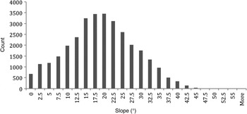
A strong relationship exists between terrace size and topographic slope. Terraces in larger agricultural districts are influenced by slope. As expected, there is an inverse relationship between the amounts of land used for rice agriculture and the slope of the topography. The average slope of the rice fields was 17.9°, while most of the fields were on slopes of between 11.59° to 25.11° (see Figure 4). To sum up, slope does not appear to be a determining factor of intensified rice production. Although it may have influenced land usage, other factors might have had stronger effects on the amount of land converted to rice agriculture.
Frequency distribution of the average slope of rice fields (y values = number of terraced rice fields)

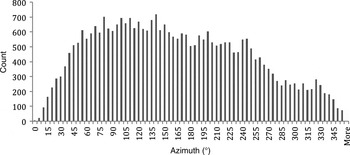
Most of the rice fields in this study are facing the east, the southeast, and south (see Figure 5). The direction of the rice fields is consistent with Conklin's findings that the south- and east-facing slopes are greener than other directions. North- and northwest-facing terraces are minimal, probably due to the relatively small amount of sunlight received in these locations.
Frequency distribution of the aspect of terraced rice fields

Nearly 75 per cent of the terraced rice fields are within 125 metres of a water source (irrigation channel) (see Figure 6). It is interesting to note that in seven agricultural districts there is no statistically significant relationship between the amount of land used for rice agriculture and the proximity to drainage. This might mean that these areas have springs or are rain-fed.
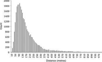
Frequency distribution of the minimum distance of rice fields from villages (y values = number of terraced rice fields)

The distribution of terraces in relation to their proximity to hamlets is not very strong. Only 30 per cent of the terraces are located within 110 metres of the nearest hamlet (see Figure 6). The rest of the distribution (70 per cent) is located between 111 metres and 985 metres. Conklin listed the proximity to hamlets as an important factor for assessing the value of agricultural land. The results of the regression analysis of land used for rice agriculture and the minimum distance of the fields from hamlets suggest the same pattern, although 5 of the 13 agricultural districts showed a statistically insignificant relationship. This exception (rice-fields and distance to hamlet relationship) might be a function of the size of the agricultural district and the concentration of hamlets (as in the case of Hengyon and Kababuyan).
Swidden fields
Shifting cultivation has been an integral part of upland lifeways in Southeast Asia as well as an important means of subsistence. Although it has many forms,Footnote 43 burning seems to be one of its unifying and indispensable aspects. Shifting cultivation is characterised by a rotation of fields between short periods of cropping (generally, one to three years) and longer periods of fallow, some lasting up to 20 or more years.Footnote 44
Shifting cultivation is also referred to as swiddening, a term that I will also use.Footnote 45 In popular literature, it is also referred to by the derogatory term ‘slash-and-burn’, which along with shifting cultivation, is reserved to describe tropical subsistence systems practised by ‘preliterate’ peoples. Peoples who engage in this type of farming are not primitive either in a technological or cultural sense,Footnote 46 nor is its geographic distribution historically limited to the tropics.
Harold Conklin pointed out that previous definitions of swiddening frequently and inaccurately implied an aimless, unplanned, nomadic movement or an abrupt change in location, either of which may refer to the cropping area, to the cultivator, or both. Conklin's study among the Hanunóo Mangyan of Mindoro in the Philippines showed that swidden systems are not primitive, but are sustainable forms of agriculture — and more environmentally friendly than most intensive forms of farming.Footnote 47 He categorised two types of swiddening: partial and integral systems of cultivation. The former refers to those farmers who practise swidden cultivation for a purely economic end, while the latter describes those whose culture is strongly tied in with cultivation (religion, rituals and community dynamics are associated with the subsistence strategy). He also pointed out that partial systems are not environmentally viable due to the lack of social structures and cultural institutions to support the system. Partial systems are also referred to as incipient swiddening,Footnote 48 where the swiddener does not have (in most cases) the appropriate ecological knowledge to develop a sustainable system. This typology of swidden systems is insightful because of the general perception that swidden cultivators are to be blamed for forest degradation and deforestation. A better understanding of swiddening forms attributes deforestation to partial systems of shifting cultivation, rather than the whole system.
Clifford Geertz echoed Conklin's assertion that integral systems are sustainable. In his study of subsistence change in Java, he stated that, in ecological terms, the most distinctive positive characteristic of swidden agriculture, and the characteristic most in contrast with wet-rice agriculture, is that it is integrated into, and when genuinely adaptive, maintains the general structure of the pre-existing natural ecosystems into which it is projected.Footnote 49
Ifugao swidden fields and the environment
In Ifugao society, rice, grown on terraces, is both economically and ritually valued over the other more abundant source of carbohydrates in their diet, sweet potatoes. The Ifugao prefer to eat rice than sweet potatoes. In fact, the amount of paddy landholdings is one of the bases for an individual's social standing (wealth). Both Harold Conklin and Peter Brosius observed that sweet potatoes grown in swidden fields provided more than half of the starch requirements of the Ifugao during the period of their respective studies (between 1960 and 1980).Footnote 50 With this in mind, we would expect that the distribution of swidden fields in the Ifugao environment would be inversely correlated to the distribution of rice terraces (under the assumption that Ifugao reserved their more productive/irrigable agricultural lands for rice production).
The Ifugao practise a form of complementary swidden farming. All districts have access to swidden land, but no district relies solely on swidden cultivation. Burned clearings on hillsides, too steep or unsuited for irrigated terracing, are cropped for about three years and then fallowed for two or three times that period.Footnote 51 Similar to statistical tests I ran with the distribution of rice terraces, this section also tested the amount of land used for swidden cultivation against the same environmental parameters used to analyse rice fields.
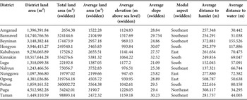
Statistical analysis of environmental parameters suggests that Ifugao farmers are able to cultivate most marginal areas for dry-crop production. Compared with rice fields, swidden plots are located in less productive areas. This distribution, however, does not mean that swidden fields offer lower yields than rice fields. The summary of descriptive statistics of swidden fields is presented in Table 5.
Summary of swidden field features from individual agricultural districts

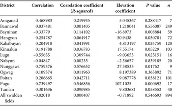
Ethnographic information suggests that swidden fields are located at higher elevations than rice fields. As expected, there is a significant correlation (inverse) between elevation and the amount of land used for swidden fields (Table 6). The average elevation of the swidden fields in the study area was placed at 1,124 metres above sea level — about 75 metres higher on average than rice fields. The distribution of the swidden fields across elevations was also uneven.
Results of linear regression between size of individual swidden field and elevation

Relationship between the distribution of swidden fields and agricultural terraces
Recently, the evolutionary relationship between intensive and extensive cultivation systems has been questioned in light of ethnographic information that illustrates the importance of swiddening to highland populations. Similarly, this investigation supports the contention that intensive and extensive systems have complementary relationships rather than an evolutionary one. Furthermore, I argue that the presence of swidden fields among intensive cultivators is a risk-minimising strategy.
The prevalence of agroecosystems among upland Southeast Asian populations supports a different view of intensification. For instance, in the northwestern highlands of Vietnam, there are subsistence patterns that are similar to Ifugao strategies.Footnote 52 This suggests that the complementarity of swiddening, household gardening, animal husbandry and an intensive paddy rice system serves to buttress the seasonality of cropping as well as any climatic fluctuations that might affect annual growing cycles.
Among the Ifugao, this risk minimisation is supported by the distribution of swidden fields across the landscape. Of the swidden agricultural districts investigated, 13 show a significant distribution vis-à-vis the rice-growing area. Swidden fields are statistically in close proximity to rice fields but on steeper slopes and somewhat further away from hamlets.
The Ifugao agricultural system adds to the increasing data that refute an exclusively evolutionary relationship between swiddening (long-fallow) and intensive forms of production. The extant models under-represent the complementarity of upland tropical agrarian systems with intensive rice agriculture. As this study shows, the Ifugao (at least in Banaue) practise annual wet-rice cropping that involves short-fallow (4–6 months) and a single harvest per year. Given that the harvest is not sufficient to supply the carbohydrate needs of the population, this supports the observation that rice cultivated in irrigated terraces is more of a prestige good.
With regard to labour requirements, Conklin calculated that one hectare of highland pond-field surface area requires a minimum of 630 days of farm labour per year.Footnote 53 Direct swidden work requires 250 days of agricultural labour per hectare per year, and maintaining a hectare of woodlot requires an average of about 20 human-labour-hours a year. Although production estimates for swidden fields are non-existent, calculations on work hours provide an impression that this farming system supplies substantial subsistence resources for the Ifugao. Upland populations are able to farm both paddy and swidden fields because of the seasonality of labour demands (cropping cycles), and thus each system complements the other.
Summary: The Ifugao agricultural system
The topographic locations of terraced rice fields and swidden fields in the North Central Cordillera suggest that the two subsistence patterns are interrelated. Although wet-terraced fields are clustered along relatively gentler slopes and swidden fields are scattered on higher elevations and steeper gradients, production requirements, consumption needs and social factors (i.e. status and prestige) provide evidence of the complementarity of the two subsistence patterns. Thus, landscape as well as ethnographic information obtained for this study underscores the interrelatedness of the two production strategies in a single integrated system.
The primary goal of this article is determining the relationships between land use and environmental and social factors. Within intensification debates and Brookfield's definition of the intensification of production,Footnote 54 the landscape of the Ifugao can be categorised as marginal for full-scale agricultural production and especially marginal for wet-rice cultivation. Thus, tests used in this study provide empirical information on the energy needed for rice terracing in Ifugao (i.e. slope, distance to water source and hamlets) to support the concept of intensification through landesque capital.Footnote 55 There is a need to look at both ecological and social factors that might explain the Ifugao choice to engage in wet-rice cultivation, despite the unsuitability of the environment to such farming. The significance of multiple strategies that include swidden production bridges the instability presented by the terrain in intensive systems.
Slope was found to be a factor in determining types of land use, which is consistent with Conklin's findings regarding the effects of slope on rice terracing and swidden cultivation. Correlation and regression analyses values are statistically significant and demonstrated that slope had the strongest effect on the amounts of land used for the types of studied features: terraced rice and swidden fields. Additionally, the results reveal a high correlation between the amounts of land devoted to farming and the size of villages such that the percentage of land used for rice agriculture and swidden cultivation seemed to be a function of population size. This relationship between larger agricultural districts and the amounts of land used for plant production can be viewed as an ‘incentive factor’ because the environment approaches optimality with more sources of water and land area available for cultivation, i.e. larger basins can attract and sustain larger populations.
The distribution of swidden fields was also affected by topographic factors examined in this study. This difference might be caused by the different types of technology employed by farmers using these types of plant cultivation. With rice agriculture, the intensive nature of production requires people to drastically modify their environment and thus offset the effects of marginal lands. In doing so, they are able to remain on particular land sites and do not need to continually move to less favourable fields. Swidden cultivation, however, represents agricultural extensification such that people cultivate a particular land area for only three years before moving to cultivate another area while allowing the original land area to remain fallow for six years before returning to it.Footnote 56 Thus, these different practices help to explain the location of swidden fields on relatively steeper slopes and more marginal lands.
Ethnographic information corroborates the results of the GIS analysis carried out in this study. Moreover, these datasets suggest the following patterns: (a) a diversified system usually uses both paddy and swidden; (b) the Ifugao started with paddy and then added swidden; and (c) Ifugao who do not have paddy fields use swidden. These features of Ifugao agroecology imply risk minimisation that combines two subsistence patterns. The interrelatedness of the strategies employed by the Ifugao (and other upland populations in Southeast Asia) challenges the unilineal model of agricultural intensification progressing from swidden to wetfield agriculture.
Although the model presented has produced statistically significant numbers in the regional analyses, this study focused explicitly on environmental–deterministic factors. The coefficients of determination reflect that less than half of the processes that have affected land usage in North Central Ifugao have been explained by these factors. Social aspects of intensification as well as of land use, as proposed by Harold Brookfield,Footnote 57 Barbara BenderFootnote 58 and Bennet Bronson,Footnote 59 might be among the other factors that played significant roles in the processes in Ifugao.
Foremost of these social factors is the status of rice as a symbol of wealth. As mentioned, rice-landholdings traditionally measure a person's wealth in Ifugao. As such, this aspect of Ifugao culture could be driving production intensification and expansion of terraced rice fields. Ethnographically, this is quantifiable, but it is impossible to investigate archaeologically.
In terms of ecological concerns, the apparent unpredictability of the terrain in terms of agricultural production in Ifugao leads to the importance of the commons (public woodlots available for swiddening). Although swidden fields become semi-private property because of the energy investment of the person/family who has cleared the area, common property serves as a buffer to the variability and limited access to rice fields. Furthermore, conversion to a permanent private landholding (rice field) is too expensive for an individual/family. Ifugao custom demands a series of rituals and feasts before a person of lower status can claim a plot of land. Thus, social norms restrict the conversion of common property to private landholding. Ethnographic information and agricultural practices also corroborate this assertion. Since the area cultivates a single-harvest-per-year rice variety, paddy landholdings and eating rice on a regular basis become status symbols. The more substantial produce from swidden fields, such as sweet potatoes, is considered common food, devoid of prestige.
Thus, identifying the social factors ethnographically would allow us to better understand subsistence strategies. Combining these datasets with ecological and archaeological components would provide a stronger comprehension of agricultural complexes. Such integration would allow us to reposition subsistence strategies away from unilineal and ambiguous concepts.
This investigation of Ifugao subsistence strategy provides an added dimension to debates about agrarian change. Although this is not a new perspective, empirical data obtained from the Ifugao landscape and ethnographic interviews further illustrate the limitation of unidirectional models for understanding complex and complementary systems.