

During the first half of the nineteenth century, the territory of the United States nearly tripled in size as the nation expanded across the continent from thirteen Atlantic-side states south to the Rio Grande and west to the Pacific Ocean. This expansion was accomplished in three broad and interrelated phases. Footnote 1 First, the federal government asserted legal sovereignty over the nation’s continental borders through a series of diplomatic treaties and purchases signed with recognized nation states including Britain, France, Mexico, and Spain. Second, the government negotiated treaties and engaged in military actions with Indian nations to remove hundreds of thousands of people who lived on and held property rights over the land. Third, the government promoted a domestic policy agenda designed to populate, settle, and incorporate the vast geographic space into what became, by 1912, the first 48 states. I examine the politics of this third phase, with specific attention to federal land policy.
I argue that government officials designed and employed land policies to strategically control the scope and pace of population movements and settlement patterns. By alternatively restricting and incentivizing population movement, government officials calculated that the strategic planting of peoples could aid in expanding borders and securing territory without over-taxing an early American state that lacked important financial and military capacities. During its earliest years, when the nation actively vied with European empires and Indian nations for control of lands east of the Mississippi River, regulating land acquisition and distribution helped the government restrain population movements that could potentially lead to conflicts that would unduly stress the nation’s limited institutional resources. By the early nineteenth century, land policies were designed and utilized to allow the nation to expand compactly, to settle and secure contested frontiers by being “full on this side” before forging further into vast geographic spaces. In the latter half of the century, as the nation gained land, population, and institutional capacity, the government continued to employ land policies as a way to manufacture demographic patterns to more quickly incorporate territories that were sparsely populated with American citizens.
The importance of federal land policies in securing and incorporating territorial borders illuminates an under-examined mechanism by which developing nation-states, even those with limited bureaucratic and military capacity, can successfully assert power over a vast and difficult geographic terrain. As such, my argument engages with scholars of both American and comparative politics interested in state formation and consolidation. Scholars of comparative state formation, for instance, have long focused on the singular importance of war for the initial development of a nation-state’s institutional capacity. Military conflicts are thought to be necessary to spur developing nations to build strong militaries and large bureaucracies in order to establish a monopoly over the legitimate forms of coercion within a given territory. Footnote 2 The United States is typically left unaccounted for within this literature because the formation of US borders are thought to be exceptional and incomparable with the experiences of other nations, particularly those of Western Europe that first provided the empirical foundation for much of the theoretical development within this field. It is argued that US state formation is better explained by a unique range of non-political factors including a distinctively strong society that, with the help of unprecedented migration from Europe, was able to dominate a sparsely populated terrain already thinned by germs and technology. Footnote 3 The US also benefited from geographical isolation and the absence of powerful competitors on its borders. As Tocqueville wrote, “Fortune, which has showered so many peculiar favors on the inhabitants of the United States, has placed them in the midst of a wilderness where one can almost say that they have no neighbors. For them a few thousand soldiers are enough.” Footnote 4
This belief in “American exceptionalism” has also left imprints on the research agenda of American political development scholars (APD) as the field traditionally bypassed the nation’s earliest years of border formation to focus instead on state building in the latter half of the nineteenth century when, prompted by the Civil War and the industrial revolution, government actors embarked on an unprecedented institutional deployment that eventuated in “a new American state” and the nation’s eventual entrance as a world power. Footnote 5 In recent years, APD scholars have begun to revise these accounts of early American state building, with some paying greater attention to the role of the military in promoting national security and border control in the nation’s earliest decades, arguing that military operations were often critical for conquering territory, removing Indians, maintaining slavery, and jump-starting the economy, even with a relatively small number of soldiers fighting in relatively “small” wars. Footnote 6 Although influenced by this work, my argument is different, instead joining a second group of revisionist scholars—both within APD and within the politics of comparative state formation—who emphasize the importance of non-militarized domestic policies such as the creation of media, mail, and transport that enable developing nation-states to “broadcast power” over vast, contested, and often sparsely-populated political geographies. Footnote 7 Land policies were particularly critical in enabling the government to overcome a weak conventional state by incentivizing and strategically privatizing an “armed occupation” of citizens to settle and secure territory. As the economist Douglas Allen has theorized, land policies can reduce the costs for governments to defend geographical space by strategically mobilizing and funneling the choices of settlers to “rush one area” and secure the contested land through population density. Footnote 8 Exertions of the state’s coercive power come from harnessing and strategically controlling society. What is critical in this argument is that neither a strong state nor a strong society is sufficient in understanding American state development; instead, land policies reflect a conventionally weak state that attained profound results by passing policies that enabled it to be both strengthened by society and make that society stronger by regulating its movements in a manner that maximized its resources and avoided overextension.
Land policies also enabled the early American state to use an institutional intervention to overcome an important ideological obstacle to expansion that was presented by the politics of race. At first glance, this is a counter-intuitive and surprising claim. After all, scholars have importantly pointed to the way that racial ideologies and the politics of slavery fueled national expansion by legitimating the taking of other peoples’ land. Footnote 9 But these ideologies and politics were more complicated in their implications for national development; they also worked to importantly limit territorial acquisitions in two significant ways. First, the political divisions over slavery meant that every contemplated taking of a new territory or geographic space, from Kansas to Texas to Cuba, as well as tangential fights over immigration, railroads, and land distribution policy, would involve a national debate over the potential such expansion would have for the delicate balance of slave and free state representation. Second, and even more directly, expanding territorial borders during this time necessitated confrontations between the US and the hundreds of thousands of people already living on the land. Political leaders had to make decisions about how they ‘imagined’ the national community: should these populations be incorporated, should they be removed to areas beyond the incorporated border, or should the nation stop expanding and leave certain populations on the other side of the border? Footnote 10 All three of these options were chosen at different times, and race was a critical intervening factor. On the one hand, naturalization laws extended to all Europeans, enabling the relatively swift incorporation of the French population in Louisiana and Germans settlers in Wisconsin. By contrast, the Indian Removal Act of 1830 mandated nearly one hundred thousand people leave their homes for lands across the Mississippi River, with reported casualties in the tens of thousands. But even when the public endorsed outright removal and exclusion of indigenous populations, it was not always institutionally possible. Removal was not simply a stark contradiction to democratic ideals, but also costly (Indian Removal and the Seminole Wars, for instance, dominated the federal budget in the 1830s), and frequently thought of as ineffective and beyond the capacity of state agencies. So, US leaders sometimes chose the third option of turning back when faced with the possibility of acquiring large populations that they deemed unable to incorporate as citizens—for example in Cuba, Santo Domingo, and “all of Mexico.” Footnote 11 When the US did continue to move forward in areas with large “non-white” populations, government officials delayed full political incorporation for many decades, as with Indian Territory, New Mexico Territory, and Hawai’i. Footnote 12
Land policies provided government officials an institutional mechanism for taking territory that manufactured racially-specific outcomes with less public visibility, enabling the government to maintain at least the appearance of fidelity to national ideals. Footnote 13 Indian removal and the violence it entailed cannot be minimized—the actions of the United States during this period would constitute genocide under current-day international law. But the Indian Removal Act was only one piece of a far broader, systematic, efficacious, and yet “unexceptional” taking of land. Footnote 14 Legislators clearly intended that these land policies could change the racial demographics of a specific geographical terrain; they designed statutes such as the Armed Occupation Act, the Land Donation Act, the Preemption Act, and the Homestead Act to move as many settlers as possible on to contested lands to overwhelm and numerically dominate the pre-existing populations. Only after this successful rush and push created a majority of whites residing in the territory would Congress vote to formally incorporate the land as a state.
I organize this material historically, utilizing government documents, newspapers, and private papers to uncover the motivations and techniques of federal policy-makers who implemented land policies. I first focus on the use of land policies to secure and settle territory east of the Mississippi River. I next examine how the Homestead Act was used to manufacture settlement patterns in the west, particularly as a way to respond to sizeable populations that many Americans believed were not able to be incorporated as citizens. Despite the broad time period and geographic space that I cover, my interest and focus is more narrow: I am not proposing a comprehensive history of American expansion, of Indian removal and resistance, of the politics of statehood incorporation, or of the range of purposes that land policies played for commerce, resource management, and civic education. Footnote 15 I am interested in illuminating previously unexamined empirical evidence that suggests the important contribution of federal land policy to American state formation and incorporation with the further goal of contributing to our theoretical understanding of what constitutes state authority and institutional strength. Footnote 16 The material is drawn from a broader collection of documents that examine federal records over land policy, Indian removal policies, and 30 different state incorporations between 1812 (Louisiana) and 1912 (New Mexico and Arizona). Footnote 17 In some legislative debates over state incorporation, there was little mention of the calculations discussed here, and more broadly, government officials never spoke with one voice about the goals of land policy, expansion, or state formation. My point is not that there was a singular driving force behind American expansion: indeed, the process of American expansion is not a single case study, and the variance of cases are a product of specific geographic, demographic, and temporal foci that differently informed policy enactments. Nonetheless, the extensive citations to federal documents are suggestive of an ambitious and historically consistent policy agenda employed in response to a reoccurring set of conflicts. In the conclusion I return to ongoing debates about what constitutes state authority in the process of territorial incorporation. Ultimately, while I hope to illuminate a state of great consequence, I argue that this reflects an alternative form of state authority, but not necessarily an equivalent or ideal form.
A Weak State Acts Robustly by Limiting Its Boundaries and Advancing Compactly, 1763–1820
From the nation’s beginnings, many Americans had grandiose designs for territorial expansion. States such as Connecticut, Georgia, and Virginia claimed vast lands that went well beyond their settled communities and many national leaders aspired to go further, with some desiring an empire modeled after Rome and Britain. Others, such as Thomas Jefferson, believed it “impossible not to look forward to distant times, when our rapid multiplication will expand itself beyond those limits, and cover the whole northern, if not southern continent.” Footnote 18 Much of this thinking paid little mind to the potential of encountering people who lived on and owned the land. The frontier was frequently discussed as if it was unpopulated, an expanse of “vacant lands.” Footnote 19 The Treaty of Paris that established the nation’s first borders in 1783 was made with European nations, excluding the many Indian nations within the territorial limits. Similar exclusions of indigenous populations occurred in subsequent treaties with European and post-European states, from the signing with the French for the Louisiana Purchase in 1803 to the Treaty of Guadalupe-Hidalgo signed in 1848 with Mexico (refer to figure 1). Government actors handled the indigenous populations residing on these lands separately, referring to the many hundreds of treaties signed with Indian nations as a separate diplomatic enterprise in “quieting,” and asserting that Indians had a “right of occupation” to the land, but not outright legal title and national sovereignty. Footnote 20
U.S. acquisitions from recognized nation-states Footnote 21

Nonetheless, political leaders during the earliest years after independence were quite cognizant of the nation’s strength vis-à-vis not only the European empires claiming land on the continent but “the Indian nations (that) encircle the Union from Maine to Georgia.” Footnote 22 Intermittent wars and shifting alliances occurred throughout this period with no single dominant actor. Footnote 23 Government officials around the country worried of war with Indian nations that refused to abide by the boundaries established in the Treaty of Paris. Federal officials were acutely aware of their government’s institutional inadequacies with many believing they lacked both the military power and financial resources to carry out expansion. As such, the new national government continued the British policy of maintaining retracted borders so as to better maintain security; the British Proclamation of 1763 prohibited colonists from settling or purchasing indigenous lands beyond a “proclamation line” that separated the seaside colonies from Indian Territory, reducing the amount of land that the Empire needed to defend (refer to figure 2). Footnote 24 The US issued its own boundary line between the nation and Indian lands, prohibiting all settlement and land purchases outside the line, and ordering the military to remove disobeying squatters. Footnote 25 The Articles of Confederation provided Congress the “sole and exclusive right and power” of managing all affairs with Indians residing outside the boundary. Footnote 26
Proclamation Line of 1763 Footnote 30

In the years between the Articles of Confederation and the writing of the Constitution, numerous states threatened to expel Indian nations from their land, and some members of Congress pushed for war and the outright extermination of Indian peoples on the frontier. But Congress upheld the boundary line. In a letter to New York Senator James Duane, George Washington worried that the state of New York’s aggressiveness with the Iroquois could lead to war and he defended the boundary line as a way of not just maintaining peace but as a way for the nation to move more strategically in the taking of Indian lands: settle the land “progressively,” he argued, with “compact” settlements and a “formidable” barrier before advancing on the frontier. He concluded that strategic patterns of settlement and peace with the Indians “are so analogous that there can be no definition of the one without involving considerations of the other.” Footnote 27 Blaine’s report as a member of the congressional committee on Indian Affairs echoed Washington’s proposals, rejecting the option of war as ineffective and too expensive, and recommending the maintenance of the boundary line while the US increased its “domestic population, and emigrations from abroad, to make speedy provisions for extending the settlement of the territories.” Footnote 28 Henry Knox, Secretary of War from 1785–95, repeatedly counseled against war because the cost to raise a sufficient number of troops to fight battles on multiple fronts on the northern and southern frontiers “far exceed(ed) the ability of the United States.” Footnote 29 In 1789, he estimated that there were 14,000 Indian “warriors” south of the Ohio and east of the Mississippi, and another 5,000 to the north, and he worried not only that “the circumstance highly probable that, in case of a war, they may make it one common cause” but that the Spanish would join them in creating “an impassable barrier.” Footnote 31 Because an “Indian war of any considerable extent and duration would most exceedingly distress the United States,” Knox argued that the US should condense “our population instead of dispersing it.” Footnote 32 President Washington agreed with Knox, worrying that the “insanity” of some border states that were attempting to appropriate, sell, and settle Indian land outside the federally-established borderline would force the nation into an unwanted war. Footnote 33
The potential of war with Indian nations was not the only motivation for national leaders establishing control over land and borders. Government officials feared that uncontrolled settlement could lead to insurrection and the potential formation of rival settler nations. Numerous uprisings such as the Whiskey Rebellion showed that settlers living on the other side of the Appalachian Mountains could turn their allegiances elsewhere with the absence of federal roads only furthering their distance from the reigns of national institutions and culture. Footnote 34 Rufus King of New York endorsed maintaining a boundary line against settlement because the Alleghany mountains “severed the two countries by a vast and extensive chain of mountains, interest and convenience will keep them separate, and the feeble policy of our disjointed Government will not be able to unite them.” Footnote 35 Many government officials desired greater control over the land to use as an economic resource, with Federalist Party leaders in particular wanting land regulation so as to reap the revenue from selling property. Footnote 36 Additionally, government leaders feared the possibility of economic chaos: in Georgia, for example, the Yazoo land scandal arose because of unregulated sales and speculation, falsified land surveys, and erroneous buyers and sellers. Yazoo led to government officials thrown out of office, the threat of war with Indian nations and Spain, and litigation that had to be decided by the Supreme Court. Footnote 37
The government passed a range of land policies designed to maintain order. The Indian Affairs Act of 1786 and the Intercourse Act of 1790 denied both settlers and individual states from selling or distributing un-appropriate land, forbid settlement on public land, forbid trading with Indian nations without a license, and empowered the President to remove illegal settlers. Superintendents were established with the authority to regulate trade and oversee boundary enforcement with regular communication with the Secretary of War. The Ordinance of 1784, the Land Ordinance Acts of 1785 and 1790, and the Northwest Ordinance of 1787 all served to further regulate land distribution by controlling both the pace of settlement, the people who were allowed to have access to property, and to create timelines and procedural hurdles for the incorporation of territorial populations into states. Footnote 38 Federal law also necessitated that government inspectors survey land prior to distribution so as to slow the pace and influence the direction of settlement. The Land Law of 1800, followed by the Intrusion Act of 1807, further delineated government authority by creating well-defined districts that would offer public land for sale through government land officers, and then enforcing a continued ban on squatting and illegal settling. Footnote 39 The results of these policies were mixed. States battled with the federal government in interpreting whether Indians residing within their lands were subject to state or federal authority and government documents from the War Department depict a constant struggle by the military to evict settlers who had advanced illegally across the boundary line. The government frequently intervened into conflicted territories by attempting to rewrite treaties that would better fix the boundaries in an effort to assuage angry state legislators, settlers, and Indian leaders. But the combined efforts of these laws significantly regulated the process of settlement, maintaining an important degree of national control over the pace and direction of population movements. These laws empowered the federal government to intervene to prevent the many violent encounters between settlers and states with Indian nations from turning into an all-out war that federal officials feared they could not afford, and perhaps most importantly, provided government officials with more time to mobilize further institutional warrants before moving forward with territorial expansion.
Settling to the Mississippi: Armed Occupation and “Advancing Compactly as we Multiply”
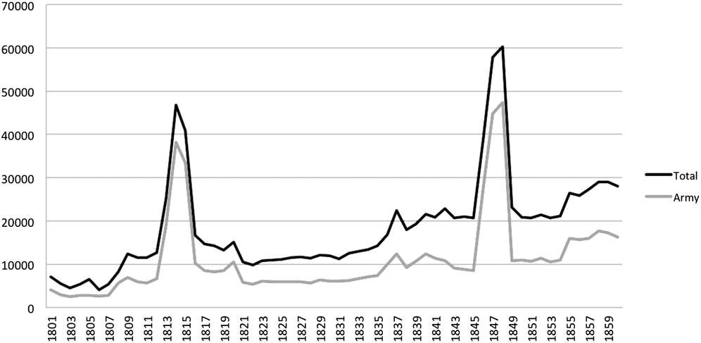
As the border line between the US and Indian Territory began to extend west in the earliest years of the nineteenth century, both with the acquisition of the Louisiana Territory and the settlement of the Northwest Territory, the government continued efforts to avoid confrontations with Indian nations, preferring to negotiate, form coalitions, and pay for any land the nation acquired. Footnote 40 Between 1800–1850, the size of the federal military hovered around 10,000 (figure 3), and officials feared its over-extension. Like Washington before him, President Jefferson and his advisors were concerned about expanding too fast, wanting to “be full on this side” of the Mississippi and “advancing compactly as we multiply.” Footnote 41 To be “full on this side,” and “advance compactly,” the US needed not just policies that regulated land dispersal, but also policies that strategically incentivized settlement on contested borders. The addition of the Louisiana Territory “increased the irregularity of the frontier boundary, and added to the number of distant and detached settlement,” wrote Senator Jeremiah Morrow for the Committee on the Public Lands. Because it created “so many assailable points” for enemies that the US did not have the means of protecting, the Committee proposed to increase the population “on the adjoining vacant territory, and proceed by a regular advance, so as to preserve always a compact population on the frontier.” Footnote 42 Jefferson recommended 160 acres be given to white males between the ages of eighteen to thirty-five who agreed to reside in the Louisiana Territory for at least seven years: “I see no security for (New Orleans) but in planting on the spot the force which is to defend it.” Footnote 43 A House report concluded with regards to the future of land claims in Michigan territory that “a liberal policy” of settlement with the use of military bounty lands would “increase the physical force of the country, so as to oppose a formidable barrier to encroachments in that quarter, and soon supersede the necessity of the maintenance of a military force there by the United States.” Footnote 44 On still a different frontier, General Andrew Jackson agreed with the Committee, advocating that Congress loosen restrictions for settlement of the Florida Territory to crowd the lands with as many people as possible to deter the Spanish from invading; the exposed land needed immediate emigration and rapid admission as a state to ward off Spanish intrusions. Footnote 45
Military personnel, 1800–1860 Footnote 54

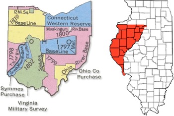
Military bounty lands were a particularly attractive way of settling contested borders. The government distributed more than 61 million acres of land to veterans, many of which were used to create militarized buffer zones along the frontier. Footnote 46 The distribution of these bounty lands allowed the federal government with scarce revenues to reimburse veterans for what was otherwise low-paid or voluntary military service. Footnote 47 Military tracts were typically placed in remote territories with sparse populations and designed to serve as a border between US territory and that of competing nations. The Federal Military Tract of 1796, for example, provided more than 2 million acres of land for military personnel to reside so that the nation could secure land north of the Ohio River (refer to figure 4). Footnote 48 President Washington argued that the land could not “be so advantageously settled by any other class of men as by the disbanded officers and soldiers of the army” because it “would connect our government with the frontiers, extend our settlements progressively, and plant a brave, a hardy and respectable race of people as our advanced post, who would be always ready and willing (in case of hostility) to combat the savages and check their incursions—A settlement formed by such men would give security to our frontiers, the very name of it would awe the Indians.” Footnote 49 The passage of the 1812 Military Tract provided bounties for soldiers of the War of 1812 including 3.5 million acres in the Illinois Tract that adjoined Indian Territory (refer to figure 4), again with the purpose of providing a buffer zone between settlers to the east and Indian nations to the west, as well as with another 2 million acres in Arkansas between the St. Francis and Arkansas Rivers sandwiched between tracts of land that had been established for refugees of east coast Indian removal efforts. Footnote 50
Ohio and Illinois military tracts Footnote 61

The aftermath of the Indian Removal Act of 1830 brought still new security issues since the policy concentrated large numbers of indigenous people within a single territory. Officials from bordering states of the new Indian Territory immediately pushed for security against what they feared would be potential attacks from more than 330,000 “Indians within striking distance,” of which Arkansas Senator William Fulton estimated that 66,000 were warriors. In response, Fulton appealed to Congress for a buffer zone to serve as a defense for the states of Missouri and Arkansas. The “object,” he said, “is to have a dense settlement of hardy adventurers all along the exposed frontier convenient to the point of danger extending along the line of our southwestern frontier.” Footnote 51 The Missouri General Assembly petitioned Congress for a more defined and densely settled state border to better separate its people who are “already surrounded by restless hordes of native savages,” that are now being mixed further with a “multitude of foreign Indians.” Footnote 52
In 1842, Congress passed the Armed Occupation Act providing 160 acres of land to those settlers who were armed and willing to occupy land south of Gainesville, Florida as a way of ending the Second Seminole War, which at the time was the second most expensive war in US history. Footnote 53 First proposed in 1839 by Democratic Senator Thomas Hart Benton of Missouri, the legislation required settlers to reside on land that was more than two miles from a military fort for seven years, building a house, and being responsible for protecting the land from Indians. Thomas Lawson, the Surgeon General, argued that military colonies would “change the system of warfare. Instead of the white men fighting the Indians in their natural fortresses, the Indians will have to come out and attack the whites within their lines of defense.” Footnote 55 Commander Thomas Jesup claimed that the object was not to beat the Seminoles, a strategy that had constantly failed, but instead “let them be crowded by settlers, and that which has invariably occurred through the whole history of our settlements will occur again, they will not only consent to remove, but will desire it as the greatest benefit the nation can confer upon them.” Footnote 56 Within a year, 1,500 people had moved to St. Lucie, Florida, and as of 1844, the Armed Occupation Act had resulted in the patenting of 1,250 claims acquiring a total of more than 200,000 acres of land. Footnote 57
The success of the Armed Occupation Act prompted calls to extend the policy to western territories. Legislation was quickly proposed to induce a volunteer force of mounted men to settle the Oregon Territory that at the time was contested between the US, British, and Indian nations. Congress removed the longstanding requirement that a government inspector first survey the land prior to settlement so as to speed the process of emigration. Willard Preble Hall, House member from Missouri, argued that Congress needed to go further: “We wish to defend Oregon. In order to do this, we wish to induce a portion of our people to remove to Oregon—TO JOIN THE ARMY OF OCCUPATION OF THAT COUNTRY. That is the object of the grants of land.” Footnote 58 Senator Stephen Douglas, Chairman of the Committee on Territories, promoted immediate settlement to secure the land against the British: in one exchange, he wrote in opposition to a proposal for building a railroad to the territory, arguing that “withholding of all those lands from sale and settlement, until your road shall have been completed, would block up the South Pass, and stop the tide of emigration to Oregon, about as effectively as the British Government, and the Hudson’s Bay Company, could desire.” Douglas argued that while they waited for the completion of the railroad, Great Britain would be sending “in the masses of her surplus population (and) extend her settlements.” If the railroad plan were employed, the result would be “a dense and prosperous British colony.” Only after “subduing the wilderness, and peopling it with a hardy and industrious population,” would the moment be right for a railroad line. Footnote 59 The Donation Land Claim Act of 1850 provided free land to those eligible to reside and cultivate land for four consecutive years in the Oregon Territory. The act resulted in more than 2.5 million acres of land going to 7,317 patents, and the policy was later extended to the Washington and New Mexico Territories. Footnote 60
Preemptions and Homesteading
By 1840, despite the addition of the Louisiana Territory, the settlement and incorporation of the United States had still not expanded significantly past its original territorial borders and the Mississippi River. As the maps of congressional districts between 1800 and 1840 in figure 5 illustrate, the US largely followed Jefferson’s dictum of being “full on this side,” by expanding the population within existing borders. (refer to figure 5). The national population more than tripled between 1800 and 1840, from 5.3 million (893,000 of whom were slaves) in 1800 to 17 million in 1840 (including 2.5 million people classified as slaves). The population would continue to grow with the help of European immigrants; between 1820, when the Census began officially counting immigration, and 1860, more than 5 million people emigrated from Europe, and the US population grew to 31 million by the eve of the Civil War. Political leaders advertised aggressively in Europe to promote emigration for labor and settlement purposes and land laws in the antebellum period had few restrictions for those who wanted to settle on lands and become US citizens, beyond being of European ancestry and desiring to become US citizens. Footnote 62 Congress members frequently lauded European immigrants for their willingness to suffer hardships “civilizing” previously “savage” lands. Footnote 63 When controversy did arise in floor debates over the free land the federal government was providing to European settlers, it was typically intermediated by the politics and divisions over slavery instead of opposition to European immigration. The decade-long debate over the passage of the Homestead Act, as we’ll see, was continually fought not over provisions that allowed European immigrants to claim free land as long as they “intended” to become citizens, but over the consequence of these populations for sectional representation. As the Columbus Democrat of Mississippi put it, “Better for us that these territories should remain a waste, a howling wilderness, trod only by the red hunter than be so settled. We prefer the neighborhood of the Wild Comanche to that of the Black hearted abolitionist.” Footnote 64
Expansion of Congressional Districts, 1801-1840 Footnote 67


The discussions in Congress about armed occupation spilled into broader debates about settler access to land. Throughout the first half of the century, settlers fought government regulation of land distribution by illegally squatting on and cultivating the land, and sometimes building homes and setting up farms. Footnote 65 Congress consistently rejected the frequent petitions and memorials from state governments and settlers asking for the right to obtain title. Many of these settlers pleaded for generosity given the cost of buying privately-held land; others emphasized the role they played in defending the land against the “ruthless savage.” Footnote 66 At times, public outcry from settlers was so great that exceptions were made. When the General Land Office was slow in making the property available in territories like Illinois, Indiana, and Missouri during the late 1810s, Congress passed a preemption act providing title to those who already inhabited and cultivated land. By the 1830s, the issue of preemption had become a major sectional divide between east and west. After eastern state members of Congress attempted to suspend surveying with the goal of slowing settlements, western states promoted an amnesty bill for squatters residing on already-surveyed land, ending in the passage of the 1830 Preemption Act, followed by a series of laws extending preemption into new territories. On the Senate floor, Democratic Senator Alexander Anderson of Tennessee argued that preemption was necessary because “in the West we have lands. We therefore want men; and men and lands constitute the greatness of our position, and from which, as a resource, we may build up a flourishing country.” Indiana Senator James Noble argued that preemption improved the land, didn’t take away value, and it gave protection to the brave settlers who are otherwise at the “mercy of the tomahawk and scalping knife.” Footnote 68 Preemption was good for the treasury, good for the adventurer, and good for “entering the wilderness” and casting “the Indians out of our borders,” which shall “form a living and massive rampart of bold and hardy men, its importance can only be estimated by a review of the actual condition of our frontier, the relations between us and the hundred Indian tribes who hover like a storm upon our Western horizon.” Footnote 69 The Secretary of War, Jefferson Davis, agreed, arguing that preemption laws “induce rapid settlement of western wilds.” Footnote 70 Preemption provided settlers an incentive to move quickly, often when the details of land treaties with Indian nations were still being actively disputed; in the immediate aftermath of the Black Hawk War, a war prompted by government surveying of disputed land in Illinois and Wisconsin territories, the federal government created a series of land offices in the region to encourage speculators, squatters, and new settlers to purchase and distribute the land as quickly as possible, leading to an “unparalleled rush for land” in Illinois. Footnote 71
The idea of homesteading, or providing settlers with free land from public resources, extended directly from the debates over preemption and armed occupation. What would eventually become the 1862 Homestead Act initially originated from Senator Douglas’ Territorial Committee, with a similarly-minded goal of establishing settler military colonies that would involve an exchange of three year’s voluntary military protection for 640 acres of land; once the land was secured, it would then be opened more broadly to farmers. Footnote 72 Congressional response to homesteading again typically divided along sectional lines, with abolitionists supporting it as a way to defeat slavery in the west, and southerners in opposition because they feared, as John Calhoun argued, they were being deprived of their “due share of the territories.” Footnote 73 But there was quite universal support for the idea of a land policy that would “occupy and cultivate our vast unoccupied domain.” Footnote 74 Even southern states closer to the frontier wavered between the fears of the impact that expansion would have for slavery’s extension and their own desire to populate the west; indeed, much of the early support for homesteading came from southern legislators, particularly Arkansas, Kentucky, and Tennessee. Senator Archibald Dixon of Kentucky typified this ambivalence, expressing fears of sectional calculations and comparative advantages brought by such a policy, but nonetheless emphatically endorsing the “great principle of settling the public lands” so as to “convert the land of the savage into that of the Christian and civilized man.” Footnote 75 Senator William Dawson of Georgia opposed the idea of land for states that were already established with the goal of increasing population: the point of homesteading was that “when we have foreign Territory which is not occupied, and it is covered by savages,” Congress should be able to “give the settlers the land, not for the purpose of a gift, but merely for the purpose of inducing them to plant themselves there to protect the rights of the whole country.” Footnote 76 James Jones of Tennessee agreed that the “wilderness” should be settled because “we are safer if we do . . . . The man who goes and encounters the frontier is as much a soldier as he who bears the musket.” Footnote 77 Nonetheless, slavery politics would be enough to defeat the Homestead Act, either through congressional vote or presidential veto, until the Civil War.
The Homestead Act and the Manufacturing of White Racial Majorities, 1862–1912
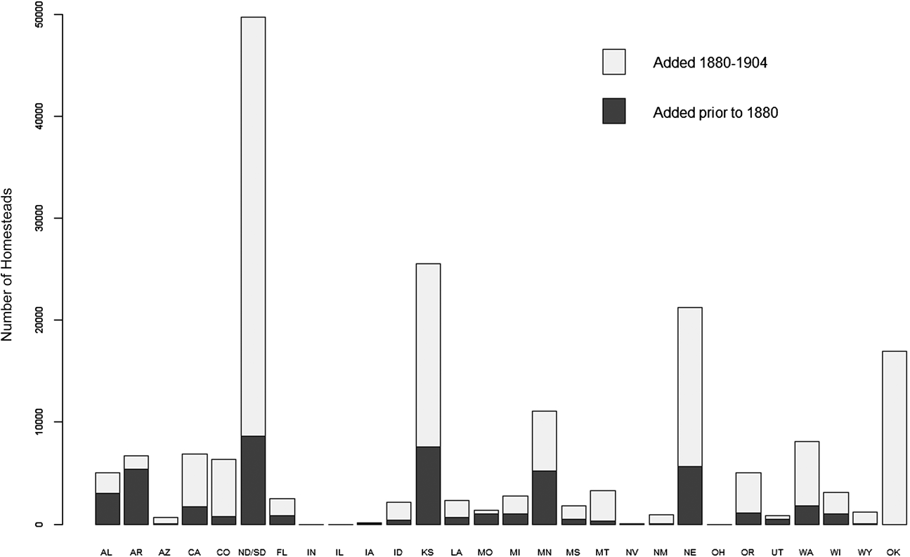
With the Civil War, US policy towards securing territory from Indian nations importantly shifted. The US stopped purchasing land or negotiating treaties, relying on military action to take lands in the west. Many western territories came under the authority of Union army leaders during the war, with the consequence of escalating military violence towards Native American nations and resulting in some of the most violent battles and massacres of nineteenth-century Indian removal. Footnote 78 The newly-passed Homestead Act often worked lock step within this new militarization. Without meaningful opposition from the South, the Act passed easily in Congress in 1862 and allowed settlers to purchase land for $1.25 per acre (in addition to a $10 entry fee), after residing continuously on the property for five years. It was followed by similar legislation such as the Timber Culture Act and Desert Land Act that further provided settlers with cheap land if they cultivated and resided on it for a set number of years. The Homestead Act alone distributed more than 96 million acres with over 300,000 individual entries over the next four decades, providing a leading catalyst for population explosions in a number of western states (refer to figure 6). Footnote 79 Homestead lands were selectively made available, and as the government made pronouncements of land openings, often before treaties were signed with Indian nations, settlers frequently rushed to contested territories in areas such as the Dakotas, Minnesota, and Utah, just as the government did with bounty lands in earlier decades. Footnote 80 The flooding of these populations frequently surrounded the remaining Indian nations, depriving them of “all chances of killing game, even for their partial subsistence.” Footnote 81
Homesteads by state, 1880-1904

But with this new assertion by the US, land policies also took on a new emphasis: they helped manufacture the racial demographics in territories with diverse populations. In this sense, Senator Douglas’s famous promotion of “popular sovereignty” was not simply a neutral endorsement for democracy but a calculation that white homesteaders would bring about a white nation. Footnote 82 For this reason, Douglas and many others opposed the continuation of Indian removal policies that concentrated Indian nations in specific territories. Douglas saw Indian Territory as “a perpetual and savage barrier to the further progress of emigration, settlement and civilization in that direction,” and he believed the first step was the settlement of Nebraska Territory, “a national necessity” that would remove the “Indian barrier.” Footnote 83 The battle over the Kansas–Nebraska Act, of course, would famously reshape a more than three-decade national compromise over slavery; but the Act also continued the process of shrinking Indian Territory, setting up the final stages for the incorporation of what would become the current state of Oklahoma.
Boomers and Sooners: Homesteading Indian Territory into Oklahoma
In the mid-1870s, Congress began discussions that eventuated in dissolving Indian Territory into the state of Oklahoma in 1907. By 1870, the population of Indian Territory was estimated at between 80,000–100,000, comprising more than 30 Indian nations including the “Five Civilized Tribes” who had been relocated there during the Indian removal policies during the 1830s and the Plains nations that were the subject of vicious fighting with the US army in the years following the Civil War (refer to figure 7). The Territory was managed by the Department of Interior, but also subject to longstanding treaties that mandated independence and autonomy for Indian nations to govern themselves. Indian nations spent much of the 1870s battling with Congress over whether lands in the territory could be used for non-Indian purposes. Some of this was brought on by Indian nations themselves, as they often rented lands to ranchers in order to pay debts and brought in American laborers to work on the land, and some of this was the result of railroad companies attempting to acquire land that ran through the Territory. Footnote 84 Members of Congress argued that if any number of “white men remove and settle in any part of the West, the United States extends over them its laws, and establishes a territorial government preparatory to its admission into the Union.” Footnote 85 Moreover, there remained a fair amount of empty land in the Territory, a result of an 1866 treaty that moved the Five Civilized Tribes east to make room for new Indian nations from the Plains to settle. As of 1879, two million acres in the middle of Indian Territory remained “unassigned,” and Congress debated whether to declare the land public and open to homesteading. Footnote 86
Removals of indigenous people to Indian Territory Footnote 94

By 1885, the Interior Department reported that it was promoting the homesteading and settlement of these unoccupied lands, claiming that “it is not beneficial to the Indians to have millions of acres of valuable land remain unoccupied around them.” Footnote 87 Indian leaders of the Five Nations hotly disputed such proposals, as well as those designed to allow railroads pass through the Territory: the new settlements, they argued, would mean the “annihilation of Indian rights, laws, and governments, and the gradual extermination of the Indians themselves.” Footnote 88 At the time, the Boomers, a small group of would-be settlers began to intrude into Indian country, following news reports claiming that the federal government was ready to declare the land public, but only to be repeatedly kicked off by the military under orders of the President. Footnote 89 In 1887, Congress passed the Dawes General Allotment Act that divided up Indian reservations (though at the time, exempting the Five Nations) into private land parcels. This further opened up land for white settlers, since the provisions of the act—providing 160 acres per household—amounted to far less than the size of the overall territory. The immediate result of the Act was the loss of two-thirds of Indian land. Footnote 90
In 1889, the unassigned lands were surveyed by federal officials, renamed Oklahoma, and declared open to settlement under the Homestead Act (refer to figure 8). The land was distributed in different phases, the first occurring at noon on April 22 on land situated immediately between the Five Tribes and Plains Tribes. The “run” for land began with the shot of a gun from a federal official: if settlers went before the gun went off—if they went “too soon”—such “sooners” were forever disqualified from obtaining future land.
Oklahoma land openings Footnote 114

Footnote 91 On that day, settlers could claim one of 11,000 quarter-sections of “unassigned lands” in territory first acquired from the Creeks in 1866. Nearly 2 million acres of land were settled that day and within the year, 62,000 settlers resided on land that was located directly between the Five Tribes to the east and the Plains Tribes to the west. Footnote 92 The government opened up another 3.6 million acres in the Public Land Strip in 1890, and by the end of the year, the population in the Territory of Oklahoma was 90,000 whites and 12,000 Indians, with many others waiting on the Kansas border for more land to open up. Footnote 93 Two years later, under more pressure from the Dawes Commission, the Cherokees sold more than 6 million acres adjacent to the Oklahoma lands in the Cherokee Outlet, leading the following year to as many as 100,000 whites in wagons rushing the land for the best tracts. Federal surveying of Indian Territory began in 1895 with the lands of the Choctaw Nation, followed by the Oklahoma panhandle. The Curtis Act of 1898 formally removed the exemption of the Five Nations and authorized the surveying and allotment of their lands. Footnote 95 By 1900, Oklahoma Territory reported 400,000 people, 92 percent of whom were classified as white; Indian Territory had swelled to 392,000, 77 percent of whom were classified as white. Footnote 96 Nearly 17,000 homestead entries were granted in Oklahoma between 1890 and 1904.
Consideration of statehood for Oklahoma began shortly after the naming of the territory in 1890. At the time, it was thought that there were 190,000 whites and another 57,000 people who were “of mixed blood, but who in personal appearance, and in their habits and customs, and in their intelligence, do not differ materially from the people who inhabit other parts of the United States.” Footnote 97 Some worried that this population mix would create problems: “With allotment comes citizenship to the Indian, ill prepared for the privileges that go with that State.” Footnote 98 In 1892, the Committee on Indian Affairs in the House began consideration of Oklahoma statehood. Footnote 99 A few years later, yet another congressional committee feared that there was a “practical denial of justice” in the Territory for the large number of whites who had settled there and lacked access to public schooling, political representation, and an adequate judicial system because they were excluded by Indian laws. The report concluded that the system of government in Indian Territory “can not continue. It is not only non-American, but it is radically wrong, and a change is imperatively demanded in the interest of the Indian and whites alike.” Footnote 100 A Senate Report in 1902 lauded Oklahoma’s potential for statehood (in contrast to New Mexico and Arizona) because of the huge numbers of white settlers now residing on the lands:
of the hundreds of thousands of people in the Indian Territory less than 87,000 are Indians. This fact is important to those who have taken it for granted that the population of the Indian Territory is of the latter race. All the conditions prevail which work for the absorption of this heterogeneous element into the body of our homogeneous citizenship.
Unlike the large Mexican populations in New Mexico, “the overwhelming body of the people” in Indian Territory was “bone of our bone and blood of our blood.” Footnote 101
The Five Tribes pushed for a separate state of Sequoyah to come in side by side with Oklahoma, proposing a state constitution in September of 1905. A vote in Indian Territory for state independence was taken later that year with the results seemingly disputed; Indian nations reported overwhelming support in the territory, whereas some media outlets claimed defeat, and most others simply mocked its possibility. Footnote 102 Statehood for Oklahoma, which incorporated Indian Territory, was granted in 1907, after a series of close votes in Congress, first in 1904 in an omnibus bill with Arizona and New Mexico, again in 1905 with New Mexico, and finally passing in March 1907 after further controversy when the state proposed a constitution with Jim Crow laws. Statehood for Sequoyah did not receive a vote in Congress. Footnote 103 By the time of statehood, Oklahoma had nearly 1.4 million people, more than 1.1 million of whom were classified as white. Footnote 104
“A Territory in Trouble:” The Six-Decade Incorporation of New Mexico Territory into a State
With Oklahoma statehood, the last unincorporated lands on the continent belonged to what had been first established as New Mexico Territory in 1850. The US acquired the land after the Treaty of Guadalupe Hidalgo ended the war with Mexico. At the time of the Treaty, the US occupied land as far south as Mexico City, and President Polk initially wanted land north of 26°N, which would have included Coahuila and Chihuahua and most of Baja, while others in the administration wanted to go even further, into Durango, Tamaulipas, and Nuevo León. “The stumbling block,” as Reginald Horsman has written, “was the Mexican people.” Footnote 105 Senator Lewis Cass from Michigan argued that the United States did “not want the people of Mexico, either as citizens or subjects. All we want is a portion of territory, which they nominally hold, generally uninhabited, or, where inhabited at all, sparsely so, and with a population, which would soon recede, or identify itself with ours.” Footnote 106 Senator John C. Calhoun argued that the US had “never dreamt of incorporating into our Union any but the Caucasian race—the free white race. To incorporate Mexico, would be the very first instance of the kind of incorporating an Indian race; for more than half of the Mexicans are Indians, and the other is composed chiefly of mixed tribes . . . . Ours, sir, is the Government of a white race.” Footnote 107 Henry Clay believed it impossible “that two such immense countries…with populations so incongruous, so different in race, in language, in religion, and in laws, could be blended together in one harmonious mass.” Footnote 108 While Whig majorities in Congress proposed leaving Mexico entirely, Democrats promoted the taking of territory in the north that was largely unpopulated. Nicholas P. Trist, sent by President Polk to negotiate boundary lines, contended “it is not our interest to acquire a territory containing much population, especially if the latter be, as is the case in northern Mexico, of a mixed colored race.” He rejected an early proposal that “includes a vast and rich country, with many inhabitants. It is too much to take. The population is mostly dark as our mulattoes, and is nominally free, and would be actually so under our government. The north would oppose taking it, lest slavery should be established there, and the south, lest this colored population should be received as citizens, and protect their runaway slaves.” Footnote 109 After careful and detailed calculations as how to best draw a boundary so as to maximize land and minimize people, the US government ended up acquiring more than half of Mexico’s territory in the late 1840s (including the disputed land of Texas) above 32N, while acquiring only 1 percent of the Mexican population.
The first territory to become a state was California (Texas was admitted immediately as a state upon its territorial acquisition). In 1848, the large territory was estimated to have fewer than 15,000 Mexicans and an Indian population of around 100,000. A huge rush of immigration immediately followed the discovery of gold, with estimates of more than 300,000 Americans entering the territory by 1854. With this “sudden and extraordinary augmentation of population,” Congress raced California to statehood in 1850. Footnote 110 By contrast, New Mexico came with a larger population of previously Mexican citizens—upwards of around 50,000. An 1850 Senate report argued that the remote and dispersed placement of the population and “the variety of races—pure and mixed—of which it consists” meant “they are not now, and for a long time to come may not be, prepared for State government.” Footnote 111 Chairman of the House Committee on Public Lands, David Disney, argued that
the obvious policy of the Government is much more urgent to induce emigration to the Territory of New Mexico than to the other Territories. Whatever of population is there is mostly foreign born; and it is important to the Government to Americanize that Territory, and to infuse into it rapidly, and at an early period as possible, as large a portion of American feeling, American tendencies, and American instincts and disposition as possible. Footnote 112
But this was not so easy. Rugged terrain and the remoteness of the region made the territory difficult to incorporate. Territorial leaders complained for decades of the difficulty of securing the land from continued Indian raids and depravations, leading the New York Times to portray it as “A Territory in Trouble.” Footnote 113 There was an early absence of railroads to penetrate the state until well into the 1870s, and agriculture was considered in primitive condition. But settlement of the territory was also importantly slowed by unique difficulties in the territory to promote federal land policy. Because much of the territory’s land was made up of large Mexican and Spanish grants owned by businessmen and ranchers, the federal government spent many decades litigating over rights to title of huge estates such as the 1.8 million acre Maxwell Land Grant. Footnote 115 For this reason, Massachusetts Senator Daniel Webster opposed its initial acquisition, arguing not only that “the country is full of people, such as they are,” but also that “there is no public domain in New Mexico. There is not a foot of land to be sold by the Government. There is not an acre that will become ours when the country becomes ours, not an acre.” Footnote 116 State legislators complained of the slow pace of land surveying and the Department of Interior complained in 1876 that government surveying was well behind the pace of other territories and that in twenty years “but seventy-one!” land claims had been confirmed because of the “complicated and confused evidences of title, most of which are in a foreign language.” Footnote 117 Governor Sheldon complained in 1883 that settlement was stalled because the territory was still “plastered with grants of land, real or presented, made by Spanish and Mexican governments. By law these grants are segregated from the public domain and must continue in a condition of practical mortmain until final action is taken to determine their validity.” Footnote 118 Corruption and land monopolies further frustrated would-be settlers; the Santa Fe Ring, it was argued, was good at using land policy to provide patronage to economic benefactors of the Republican Party but was less good at populating the territory with people immigrating from out of state. Footnote 119
As populations elsewhere increased, the population of New Mexico, and notably the number of whites, remained low, with many moving instead to Arizona territory, established during the Civil War. By 1870, only 1600 people living in New Mexico had been born outside of the territory and the US Land Office consistently reported that the territory was at the bottom in the number of homesteaders in the territories. Footnote 120 New Mexico lost a battle for statehood in Congress in the mid-1870s when it was coupled with the successful bid of the sparsely populated but overwhelmingly white Colorado. Despite arguments that the territory well surpassed the number of white citizens necessary for passage, national publications portrayed a people who “are not of us.” Footnote 121 Senator Lot Morrill of Maine argued that only one-tenth of the population spoke English, “about two-tenths or three-tenths are Indians, the men that we hunt when we have nothing else to do in the summer season . . . . And who are the others? Mexicans, Spaniards, ‘greasers.’” Footnote 122 Senator John Stevenson of Kentucky claimed that because of the few immigrants to the Territory from other parts of the US, the population remained, “exclusive of Mexicans, greasers, and Indians, of less than two thousand persons.” Footnote 123 In 1889, as the Dakotas, Washington, and Montana were being considered for statehood, New Mexicans found their population again being accused of lacking the number of American citizens necessary. Despite state legislatures that were two-thirds Republican, the national Republicans were ultimately critical for its defeat, in part concerned that the large Catholic populations would join other Catholic populations in the Democratic Party. Footnote 124 After the 1900 census placed its population at just under 200,000, New Mexico again came up again for statehood, only to be defeated by a lengthy and damaging report by Republican Senator Albert J. Beveridge of the Committee on Territories. Over the course of 120 pages, with sections entitled “Meaning of Terms ‘Mexican’ and ‘American,’” Beveridge interviewed people from all over the territory asking them how many people were American and spoke English. Footnote 125 He concluded that “the great majority are native New Mexicans of Spanish and mixed Spanish and Indian descent, and of these practically all speak Spanish in the affairs of daily life, and the majority speak nothing but Spanish.” The committee felt that Congress should continue to wait, until “the immigration of English-speaking people who have been citizens of other States does its modifying work with the ‘Mexican’ element—when all these things have come to pass, the committee hopes and believes that this mass of people, unlike us in race, language, and social customs, will finally come to form a creditable portion of American citizenship.” Footnote 126
In 1906, Congress proposed a joint statehood bill that would combine Arizona Territory with New Mexico so as to add further white populations to New Mexico. By combining the territories, Beveridge argued, “the Mexican population will be in the middle, masses of Americans to the east of them, masses of Americans to the west of them—a situation ideal for Americanizing within a few years every drop of the blood of Spain.” Footnote 127 During House hearings there was extensive debate over the actual size of the white and Mexican populations in the territories, with the chairman of the committee, Edward Hamilton, supporting joint statehood because combined with Arizona, the state would be overwhelmingly white. Footnote 128 But Arizonans protested, passing a resolution that joint statehood “would subject us to the domination of another commonwealth of different traditions, customs and aspirations.” There were strong fears in the territory that Arizona, “95 percent of whom are Americans,” would be outvoted by people of a different race, presumed to speak a different language. As one representative told the Committee on the Territories, “if we were united with New Mexico, in New Mexico they would have the majority of the votes as against Arizona . . . . They would not surrender the rights to have there to sit upon juries, to be members of the legislature, and to occupy any elective office.” Footnote 129
New Mexico became a state, months before Arizona, in 1912. The Census in 1910 put its population at 327,000, with another 204,000 in Arizona. The populations of both states had doubled over the prior two decades. Although legislators continued to ask about the “45 percent of Spanish descent” who lived in New Mexico, hearings on statehood in 1911 emphasized the many Americans from “every State in the Union” that now lived in the territory. “The entire increase of population, you might say, is what we would call Americans. There is no increase by immigration among the Mexicans.” Footnote 130 But unlike the process of settlement for so many other states, New Mexico remained distinctive, something that other legislators celebrated, noting the importance of the Spanish population that “carved a civilized state out of the wilderness, that wrested it from the Indians and consecrated it forever as the theater of the transcendent achievement of the Spanish-speaking people upon the American Continent.” Footnote 131 It entered the union with a state constitutional mandate for bilingualism in all government and legal services.
Implications
Charles Maurice de Talleyrand once said that empire is “the art of putting men in their place.” A great deal of government activity in the early nineteenth century followed this maxim quite well: the United States devoted extensive energy controlling population movements in order to defend and settle newly conquered lands. My argument here has been that federal land policies enabled an otherwise constrained American government to assert authority over the direction and pace of expansion and settlement and to maintain an official fidelity to constitutional principles while conquering territory, removing indigenous populations, and engineering a dominant racial vision by manufacturing white majorities in lands populated by diverse peoples. As such, these land policies reflect an alternative model of state authority that relies on incentivizing private forms of coercion in the absence of more conventional institutional weapons and ideological legitimacy for public violence. This claim contributes to ongoing debates within both the comparative state formation literature and within APD that are recasting our understandings of what constitutes institutional “strength” and “weakness.” Footnote 132 At the same time, I want to emphasize that as an alternative model of authority, these land policies are not equivalent or necessarily preferable to the weapons of a more conventionally powerful state. As a policy choice, the decision by the government to incentivize private actors instead of forming sizeable government bureaucracies to mobilize population movements and settlement patterns had consequences that reflect both state strengths and constraints.
On the one hand, the success that US land policies had in securing territory is only further accentuated by the counter and failed example of Mexican land policy during this time. As mentioned earlier, a major appeal of the land that the US acquired from Mexico was that it was sparsely populated—only about 80,000 Mexican citizens lived on the roughly 400 million acres of acquired land. The emptiness of Mexico’s northern territory was itself consequential for both US and Mexican state formation. Mexican (and prior to 1821, Spanish) officials at the time were well aware of the potential threat these empty lands had for their sovereign borders. Footnote 133 During the 1810s, the Spanish Regency looked to increase “the population of Texas with the greatest possible exertion,” so as to place “an impenetrable or almost impassable barrier against the United States” and a report by the Azcárate Commission of 1821 predicted that if Texas were not populated quickly, the United States would take possession of the territory and other northern regions, “just as the Goths, Ostrogoths, Vandals and other tribes had assaulted the Roman Empire.” Footnote 134 The Mexican government passed a series of laws patterned after the United States—asserting centralized control over land distribution with the help of on the ground surveyors, and attempting to incentivize foreign settlement. But Mexican officials went about implementing these policies haphazardly and with little impact. Footnote 135 Distracted by threats to the central government and rebellions from other parts of the country, government officials complained that there was minimal oversight and information about land distribution on the frontier. Local leaders in the northern territories frequently made their own deals in distributing land, most often contracting with American businessmen with whom they had personal ties. Footnote 136 Efforts to move settlers who would be loyal to Mexico to these territories—such as plans to relocate Mexican prisoners, attract Canadians in search of warmer climates, or provide colonies to 10,000 Swiss militiamen and freed African American slaves—were never implemented. Footnote 137 A last-ditch effort to establish military forts in Texas is particularly emblematic of the failed use of land policy; without providing bounty lands for armed settlements of the kind that the US implemented with such success, when the Mexican government abandoned its northern garrisons in 1832 to meet a political crisis in the capital, they left the land empty. Footnote 138 By 1836, the year of the Texas Declaration of Independence, the population of Texas had increased to over 40,000, a substantial increase from the 2,500 that lived there in 1821. But records show that only 3,500 of those living in the territory were Mexican citizens, with the overwhelming majority of the population having recently emigrated from the United States. Footnote 139
And yet, I do not wish to argue, as some revisionist scholars have done, that the nineteenth-century American state was neither weak nor importantly constrained. Footnote 140 The success of US land policy derives from the ability of federal officials to implement these laws in the absence of better institutional weapons, but land policies did not remove other weaknesses of the American state. In fact, many of the features of land policies that made them effective for expansion and settlement—such as relying on private actors with the help of incentives—are the same features that continually hindered, and continue to hinder, other national policy goals. Reliance on private incentives and a more flexible and less visible bureaucratic state can enhance state authority, but incentivizing private actors is not equivalent to administrating with publicly accountable officials. Footnote 141 If we are faithful to the historical details, and particularly the varied institutional and geographic sites in which such history develops, we ought to more modestly recognize that states have multiple tasks and skills, all of which are subject to different institutional and temporal configurations. Footnote 142 This is why it is worth emphasizing and contrasting the ambitions of American leaders at the time with the outcomes of American expansion. The results of American conquest are certainly significant, but the boundaries could well have been far more expansive had nation builders not been constrained by a small military and a need for manufacturing white majorities. Land policies are effective in overwhelming populations in certain contexts, but federal officials also rejected additional areas of potential expansion because of a belief that such policies would not be sufficient in securing and incorporating more substantial populations.
This ambivalent record of land policy is particularly notable regarding its consequence for the national construction of racial demographics. Although we see a quite significant “racial state” that maintained racial hierarchies through the institutional manufacturing of political geography, at the same time the reliance on land policies—as opposed to more conventional coercive forms—enabled a certain amount of racial diversity to thrive on the frontier despite a white hegemonic society. Footnote 143 This diversity is not just a result of ideological conflicts and multiple orders, as Desmond King and Rogers Smith importantly argue, but is also institutionally constructed from weaknesses in the capacity of the American state that enabled these pockets of diversity to withstand eradication, particularly on frontier borderlands. Footnote 144 The continuing presence of racial diversity in turn maintained pressure for the ongoing transformation of the nation’s demographic core, a transformation that remains in a modern society where those who want to reinforce and reestablish long-standing racial hierarchies coexist with the election of Hawaiian-born president Barack Obama.
Finally, I want to conclude by emphasizing a theme implicit through this work: the centrality of race in the formation and development of the American state. Bringing race to the center does not simply add new facts to a conventional story about American expansion and incorporation, but fundamentally alters its conclusion. Arguments that the US lacked substantial enemies in its earliest years significantly miss how much the federal government was concerned with and subsumed by the presence of Indian nations both on and within their borders. Arguments that the US expanded quickly and “easily” during the antebellum era to a natural resting place on the shores of the Pacific miss not only the continuous contestation over race that shaped the taking and contemplated taking of just about every single piece of geographic territory, but also—and perhaps more profoundly—the reasons why the United States would choose the path of a settler nation as opposed to a traditional empire. Of course the US was frequently imperial, from the Indian Removal Act of 1830 to the capture of Geronimo in the mountains of Arizona at century’s end, from its role in the slave trade to the takeover of Hawai’i and the long-standing colonial politics of Puerto Rico. But unlike most prior empires, the United States was uninterested in incorporating new populations and territories unless they could be populated with a majority of “Americans,” a term that was racially bounded throughout the period of American expansion. In the end, it was race—more than a lack of ambition, powerful enemies on its borders, or weak state institutions—that hindered the further expansion of national borders and determined their ultimate contours.
Paul Frymer is Associate Professor in the Politics Department at Princeton University (pfrymer@princeton.edu). He thanks Jeff Isaac, the anonymous reviewers at Perspectives on Politics, and the many people who have commented on different versions of this paper too innumerable to mention, but in particular, Amy Bridges, Michael Brown, Ira Katznelson, Rob Mickey, Nick Parrillo, Rogers Smith, Sarah Staszak, and Deborah Yashar for offering detailed readings and comments on the paper. He also thanks Sean Beienberg and Masha Krupenkin for excellent research assistance, and Steven Morrissey for the title.