1. Introduction
In eastern Thailand, the Sa Kaeo Suture is the boundary between the Permo-Triassic Sukhothai Arc Terrane and the Loei–Petchabun Fold-Belt Terrane (Fig. 1a) and has been linked to the Nan Suture in northern Thailand (Bunopas, Reference Bunopas1982). Both sutures are generally now regarded as remnants of a Permo-Triassic back-arc basin that closed prior to the intrusion of granites in Late Triassic time (e.g. Metcalfe Reference Metcalfe1996; Ueno & Charoentitirat, Reference Ueno, Charoentitirat, Ridd, Barber and Crow2011). However, recently acquired Devonian (e.g. Yang et al. Reference Yang, Feng, Shen and Chonglakmani2009; Shen et al. Reference Shen, Feng, Yang, Zhang and Chonglakmani2010) dates on mafic igneous rocks within the Nan Suture zone suggest that the two are not linked and that the Nan Suture may be a remnant of a larger and long-lived ocean as originally envisaged by Bunopas (Reference Bunopas1982). No fossils or mafic igneous rocks older than Permian have yet been found in the Sa Kaeo Suture, which supports the general assumption that it is a Permo-Triassic back-arc basin.
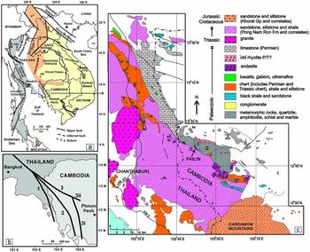
(a) Simplified terrane map of mainland South East Asia with major terranes and sutures showing study area locations. BRS – Bentong–Raub Suture; CM – Chiangmai; DBF – Dien Bien Phu Fault; HN – Hainan Island; LPB – Luang Prabang; MPF – Mae Ping Fault; MYF – Mae Yuem Fault; NR – Nakhon Ratchasima (Khorat); PKF – Poko Fault Zone; S – Simao; TPF – Three Pagodas Fault; TPS – Tamky–Phuoc Son Suture; TKF – Thakhek Fault. (b) Diagrammatic map showing the three main postulated trends of the continuation of the Sa Kaeo Suture from or in SE Thailand into Cambodia from various authors. 1 – Paralleling the Thai–Cambodian border and following the imposed Indosinian Orogenic grain within Thailand (e.g. Arboit et al. Reference Arboit, Collins, Morley, King and Amrouch2016). 2 – Southeasterly trend beneath the Jurassic–Cretaceous terrestrial sandstones of the Cardamom Mountains in Cambodia (e.g. Qian et al. Reference Qian, Feng, Wang, Chonglakmani and Monjai2016; Sone, Metcalfe & Chaodumrong, Reference Sone, Metcalfe and Chaodumrong2012). 3 – Easterly trend following the northern margin of the Cardamom Mountains and then either continuing east (3ii) or trending south along the Pursat–Kampot Fold Belt (3i) (e.g. Khin Zaw et al. Reference Zaw, Meffre, Lai, Burrett, Santosh, Graham, Manaka, Salam, Kamvong and Cromie2014). (c) Simplified compilation of relevant geology in eastern Thailand and western Cambodia. SE Thailand based on Hada et al. (Reference Hada, Bunopas, Ishii, Yoshikura and Dheeradilok1997), Chutakositkanon & Hisada (Reference Chutakositkanon, Hisada, Choowong and Thitimakorn2008) and maps of the Geological Survey Bureau, Department of Mineral Resources, Bangkok. Western Cambodia geology is based on 1:500000 scale map of the Pak Nam sheet mapped by J. Gubler in 1935 with additional mapping by E. Saurin in 1962 for the Service Géologiques de l'Indochine and the 1:200000 BRGM map of the Pothisat sheet by Dottin & Zinszner (Reference Dottin and Zinszner1972). Although originally regarded as Devonian, the Cambodian cherts are now, at least in part, reliably dated herein as Early Permian in age. By comparison with cherts in adjacent parts of Thailand, it is probable that both the cherts and the other sedimentary rocks near Pailin are also Permian. South of Pailin, the turbiditic sandstones are correlated with the Triassic submarine fan deposits of the Pong Nam Ron Formation. Point 1 – old abandoned quarries on eastern outskirts of Pailin; Point 2 – new, recently active, quarry to east of Pailin, lat. 12°49′51″N, long. 102°36′43.44″E, elevation 227 m; Point 3 – Phnom Kiaow, steeply dipping succession of shale/sandstone with poorly sorted sandstone-greywacke at top of hill, near waterfall at lat. 12°47′48.835″N, long. 102°36′56.270″E; Point 4 – Lower Permian radiolarian–conodont chert – basalt locality of Saesaengseerung et al. (Reference Saesaengseerung, Agematsu, Sashida and Sardsud2009) at Khao Phasuk (lat. 13°14′733″N, long. 102°13′807″E) in Thailand.
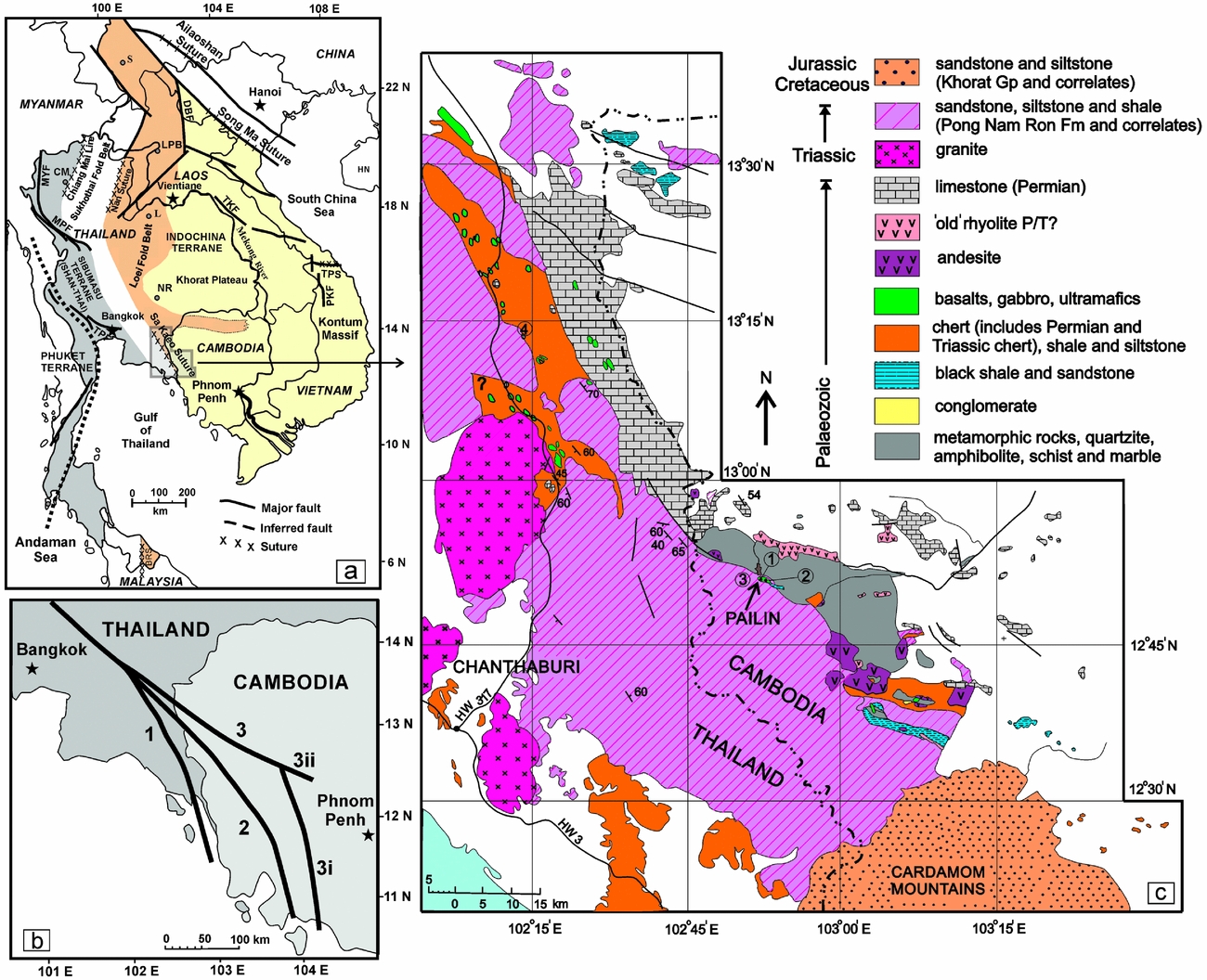
There are three main proposals (Fig. 1b) for the southerly to easterly extension of the Sa Kaeo Suture. One suggests a southerly route paralleling the Thai–Cambodian border (e.g. Chutakositkanon & Hisada, Reference Chutakositkanon, Hisada, Choowong and Thitimakorn2008; Nuchanong, Reference Nuchanong2014; Arboit et al. Reference Arboit, Collins, Morley, King and Amrouch2016), based on the general strike of strata in easternmost Thailand (e.g. Ridd & Morley, Reference Ridd and Morley2011; Arboit et al. Reference Arboit, Collins, Morley, King and Amrouch2016). A second proposal suggests a southeasterly trend heading into Cambodia beneath the Mesozoic terrestrial sandstones of the Cardamom Mountains (e.g. Sone, Metcalfe & Chaodumrong, Reference Sone, Metcalfe and Chaodumrong2012; Morley et al. Reference Morley, Ampaiwan, Thanudamrong, Kuenphan and Warren2013; Nie et al. Reference Nie, Feng, Metcalfe, Baxter and Liu2016) for which there is little evidence, and the third proposal suggests a route directed around the Cardamom Mountains, following the general trend of pre-Mesozoic rocks (e.g. Khin Zaw et al. Reference Zaw, Meffre, Lai, Burrett, Santosh, Graham, Manaka, Salam, Kamvong and Cromie2014).
Our reconnaissance survey of western Cambodia has found the eastern extension of the Sa Kaeo Suture, which includes cherts with Early Permian radiolarians and supports the proposal of Khin Zaw et al. (Reference Zaw, Meffre, Lai, Burrett, Santosh, Graham, Manaka, Salam, Kamvong and Cromie2014) (Fig. 1b, alternative 3i). These are the first radiolarians to be described from Cambodia.
Because of political instability and wars, there has been very little modern geological work in western Cambodia. Owing to a lack of good base maps and infrastructure, many of the published maps are inaccurate and many of the rock units are either undated or incorrectly dated. As elsewhere in Indochina, metamorphic rocks were often assumed to be of Precambrian or older Palaeozoic age, and tenuous chronological correlations of sedimentary sequences were made on the basis of very little or no evidence.
2. Geological setting
2.a. Geological setting of eastern Thailand
Hada et al. (Reference Hada, Bunopas, Ishii, Yoshikura and Dheeradilok1997) mapped and subdivided the 60 km wide, NW–SE-trending Sa Kaeo – Chantaburi Suture Zone into a western ‘Chantaburi Chert–Clastic Sequence’ and an eastern Thung Kabin Mélange. The western chert–clastic sequence consists of tectonic slices of alternating red chert, containing Middle to Late Triassic radiolarians, and coarse clastic units, interpreted as an accretionary complex. The eastern Thung Kabin Mélange consists of strongly foliated serpentinite matrix surrounding ‘inclusions’ of dominantly basalt, limestone and chert with minor sandstone, conglomerate, metamorphic rocks and granite. The cherts contain Early, Middle and Late Permian radiolarians and, rarely, conodonts and the limestone blocks contain Early, Middle and Late Permian fusulinids (Fig. 1c, point 4) (Hada et al. Reference Hada, Bunopas, Ishii, Yoshikura and Dheeradilok1997; Saesaengseerung et al. Reference Saesaengseerung, Agematsu, Sashida and Sardsud2009; Ueno & Charoentitirat, Reference Ueno, Charoentitirat, Ridd, Barber and Crow2011). Zircons from a granite clast are U–Pb dated as 486.5 ± 5 Ma, which is close to the age of the Cambrian–Ordovician boundary. Basalt blocks ranging from a few to several hundred metres in length are geochemically E-type MORB, characteristic of anomalous ridge segments and hot-spot related ocean islands (Hada et al. Reference Hada, Bunopas, Ishii, Yoshikura and Dheeradilok1997).
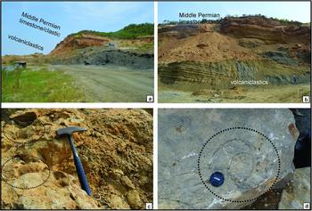
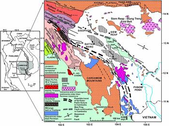
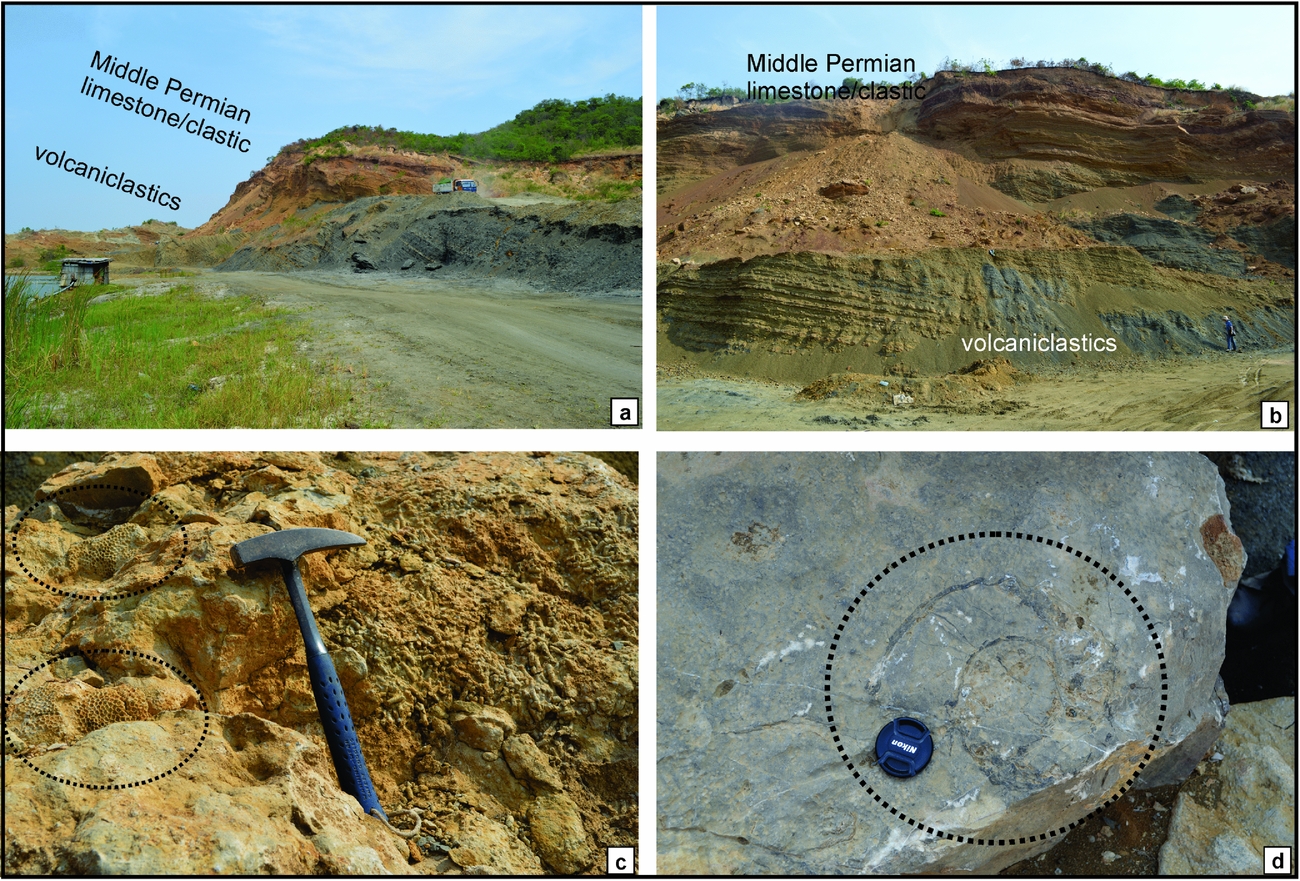
More recently, Chutakositkanon & Hisada (Reference Chutakositkanon, Hisada, Choowong and Thitimakorn2008) defined new units within the accretionary complex and mapped numerous megablocks within the mélange units (Fig. 1a). The Khao Taa Ngog Formation in Thailand and the Sisophon Limestone in Cambodia (Fig. 2) are Permian shallow-water carbonates, with a coherent stratigraphy, that may be followed from one monadnock to the next (Ishii et al. Reference Ishii, Kato and Nakamura1969; Ueno & Charoentitirat, Reference Ueno, Charoentitirat, Ridd, Barber and Crow2011). In quarries west of Sisophon, Mid Permian limestone overlies andesitic volcaniclastic rocks (tuffs) of the Member A of Ishii et al. (Reference Ishii, Kato and Nakamura1969) (Fig. 2). The sequences can be correlated with Permian limestone and tuff and tuffites in the east of the Khao Khwang Platform in the Loei Fold Belt (e.g. Wielchowsky & Young, Reference Wielchowsky, Young, Thanvarachorn, Hokjaroen and Youngme1985; Altermann, Reference Altermann1989), which suggests extension of the Loei Fold Belt into Cambodia (Fig. 1a, c). Diverse and abundant fossils such as fusulinids, brachiopods, corals, alatoconchid bivalves and others are present in these sequences and indicate a tropical regime. The lithological and faunal similarities of these Permian sequences in Thailand and Cambodia suggest a common palaeogeography or close proximity during Permian time. The Pong Nam Ron Formation and correlates in Cambodia are submarine fan deposits post-dating the accretionary prism rocks and pre-dating Late Triassic granite (Chaodumrong, Bookanpay & Seeyunghan, Reference Chaodumrong, Bookanpay and Seeyunghan2010; Ueno & Charoentitirat, Reference Ueno, Charoentitirat, Ridd, Barber and Crow2011) (Fig. 1c).
Photograph of the Permian Sisophon Limestone and andesitic volcaniclastic rocks in an active quarry, at Phnom Svai west of Sisophon town. The sequences contain highly diverse and abundant fossils. (a) At least 20 m of dark grey poorly consolidated, shallow-marine, andesitic volcaniclastic rocks (tuff) of Member A of Ishii et al. (Reference Ishii, Kato and Nakamura1969) overlain by brown clastic/carbonate sequences of Middle Permian age. (b) Well-bedded volcaniclastic rocks and limestones. Height of person for scale is 1.75 m. (c) Massive and fasciculate corals in limestone. Length of hammer for scale is 33 cm. (d) Ammonoid. Diameter of lens cap for scale is 5.5 cm. The thick basal andesitic tuff suggests an active volcanic arc in this area during Early Permian time approximately contemporaneous with the deep-water cherts further south at Pailin.
Sangsomphong et al. (Reference Sangsomphong, Tulyatid, Thitimakorn and Charusiri2013) used enhanced airborne magnetic and radiometric data to identify geophysical domains in eastern Thailand. A highly magnetic ‘Central Domain’ separates less magnetic domains and its strongly magnetic character suggests the presence of serpentinites and basalts; we equate this broad zone to both the Loei Terrane (Burrett et al. Reference Burrett, Zaw, Meffre, Lai, Khositanont, Chaodumrong, Udchachon, Ekins and Halpin2014; Khin Zaw et al. Reference Zaw, Meffre, Lai, Burrett, Santosh, Graham, Manaka, Salam, Kamvong and Cromie2014) and to the Sa Kaeo Suture along the domain's southern margin. The southern domain would then represent the Triassic Sukhothai Arc Terrane and also include the Sibumasu Terrane further south.
2.b. General geology of NW Cambodia
Gubler (Reference Gubler1935) mapped metamorphic and igneous rocks which he included in his ‘Crystallin de Pailin’. He regarded these rocks as a Hercynian (or Variscan) Massif and this was accepted by most subsequent authors. For instance, Fontaine & Workman (Reference Fontaine, Workman and Nutalaya1978, p. 672) suggested that the metamorphic and igneous rocks constituted ‘possibly a largely concealed Variscan massif in NW Kampuchea (Cambodia), the area of Precambrian and Devonian–Carboniferous around Pailin being the edge of it’.
Because of a lack of good base maps and poor infrastructure, very little locality information and very few maps were provided by Gubler (Reference Gubler1935), and many of the place names that he used are no longer recognized. Gubler (Reference Gubler1935) constructed several highly diagrammatic cross-sections and mentioned the occurrence of poorly located igneous rocks, including peridotite, pyroxenite, gabbro, diorite, basalt and rhyolite. He recognized that there was an ‘old’ deformed basalt and a younger, Quaternary gem-bearing basalt. He also recognized two ages of rhyolite. Gubler (Reference Gubler1935) identified sedimentary cherts in many localities and recognized abundant radiolarians and sponge spicules within them. He suggested a Devonian age for the radiolarian cherts by general lithological comparison to sequences in France. On the basis of the Lower Carboniferous to Upper Permian (to Triassic?) foraminifera Geinitzina and also ‘Endothyra’ he suggested a Carboniferous age for the sandstones and shales, which he placed in his ‘Serie Schisto–Greseuse’. This shale–sandstone sequence is, by comparison with sequences across the border in Thailand, more likely to be either Permian or Triassic in age (Fig. 1c). A thick sequence of coherent, steeply dipping, turbiditic siliciclastic rocks between Pailin and the Thai–Cambodian border on the track ascending Phnom Kiaow (Green Mountain) in the Todeth Mountains (Fig. 1c, point 3) is lithologically identical to the Mid Triassic Pong Nam Ron Formation in adjacent areas of Thailand.
Relatively modern mapping by geologists of the Bureau de Récherches Géologiques et Minieres (BRGM) (Dottin & Zinszner, Reference Dottin and Zinszner1972) as summarized in Figure 1c indicates small areas of a variety of sedimentary, igneous and metamorphic rocks.
To the west of Sisophon town, an active quarry contains abundant fossils of fusulines, corals, brachiopods, bryozoans and ammonoids (Fig. 2). The sequence consists of bedded calcareous tuff overlain by limestone, shale and limestone in ascending order, which are assigned to members A–D of Ishii et al. (Reference Ishii, Kato and Nakamura1969). This sequence may be assigned a Middle Permian age as indicated by the Neoschwagerina to Yabeina fusuline zones (Ishii et al. Reference Ishii, Kato and Nakamura1969; Fontaine, Reference Fontaine2002). Highly fossiliferous Mid Permian limestones and associated rocks are also present to the south of Sisophon in Battambang and nearby areas in the west of Cambodia (e.g. Gubler, Reference Gubler1935; Ishii et al. Reference Ishii, Kato and Nakamura1969; Fontaine, Reference Fontaine2002).
2.c. Geology of the Pailin area
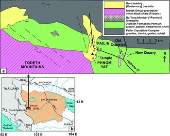
Our reconnaissance survey in western Cambodia found mafic igneous rocks and cherts within quarries in an E–W belt of hills within the eastern outskirts of and to the east of the town of Pailin (Fig. 3). This 20 km long, 1.5–2 km wide belt lies between steeply dipping greywackes and sandstones of the Todeth Group to the south and the Pailin Crystalline Complex to the north (Berrangé & Jobbins, Reference Berrangé and Jobbins1976). The Todeth Group is lithologically identical to the contiguous Triassic, Pong Nam Ron Fm in Thailand (Fig. 1c). The Pailin Crystalline Complex is ‘largely amphibolitic (metavolcanic)’ but also includes ‘granodiorite, diorite, gneiss, schist, greenstone, quartzite and basic dykes’ (Berrangé & Jobbins, Reference Berrangé and Jobbins1976). One K–Ar date of 245 Ma is noted in this complex on the BRGM map (Dottin & Zinszner, Reference Dottin and Zinszner1972) and, pending modern dating, there is no reason to ascribe the Pailin Crystalline Complex or even its protoliths to the Precambrian or older Palaeozoic. Berrangé & Jobbins (Reference Berrangé and Jobbins1976) mapped the belt between the Pailin Crystalline Complex and the Todeth Group as the O Smoet ‘Formation’ containing ‘jasper, chert, acid volcanics, quartzite, schist, phyllite, siltstone and shale’. To the west of Pailin they mapped small areas of ‘Permian’ limestone within the O Smoet ‘Formation’ as the Ba Tong Member (Fig. 3a).
Locality maps of western Cambodia. (a) Locality map of Pailin area in western Cambodia showing quarry localities. Radiolarians have been obtained from the western end of the ‘new’, recently active, quarry at lat. 12°49′51″N, long. 102°36′43.44″E, elevation 227 m which is c. 900 m west of three ‘old’ abandoned quarries. The E–W-trending range of hills continues for at least 10 km to the east and 6 km to the west. Mapped units and names are from Berrangé & Jobbins (Reference Berrangé and Jobbins1976) and may be based on geographic names not in current use. (b) Location of Pailin, Battambang, Sisophon, Siem Reap and Pursat in western Cambodia and Chantaburi and Trat in SE Thailand. Shaded area is Battambang Province, western Cambodia.

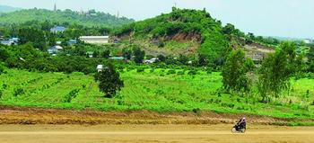
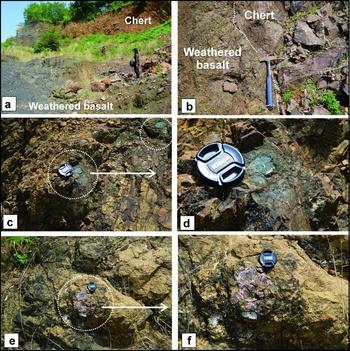
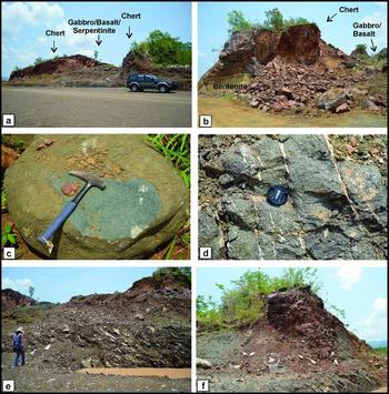
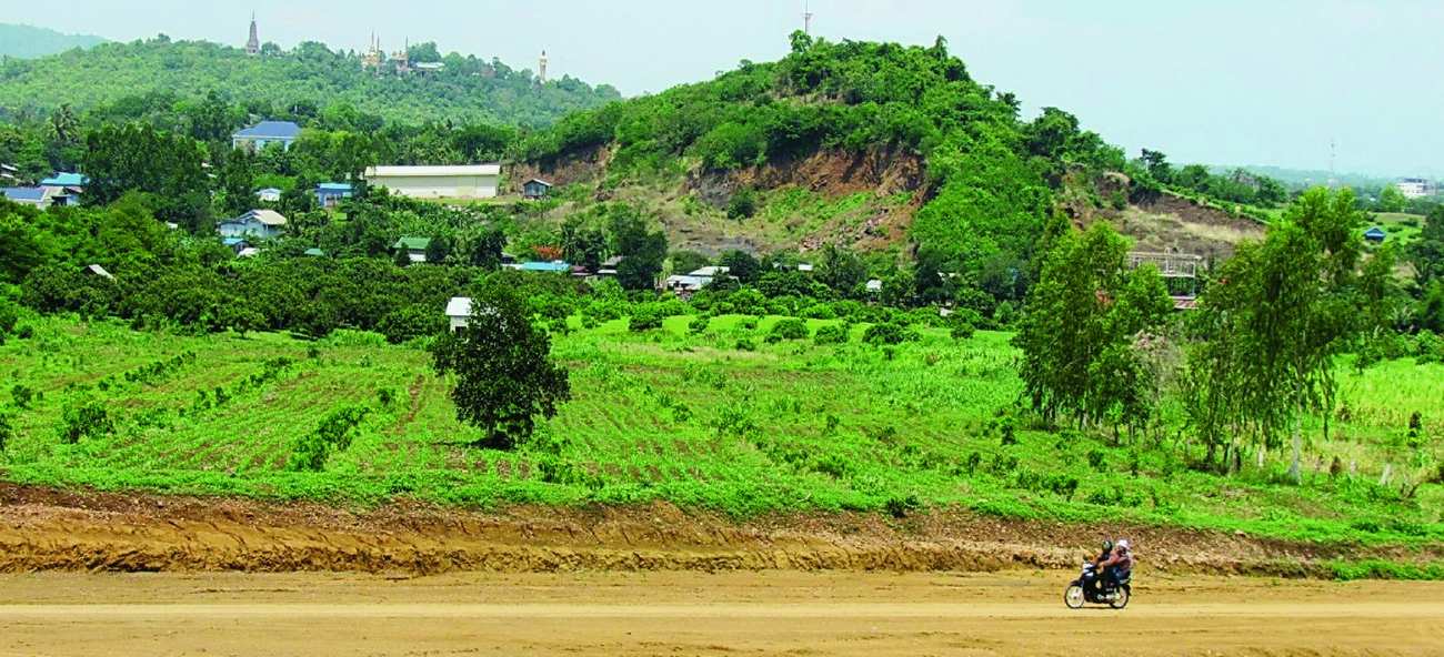
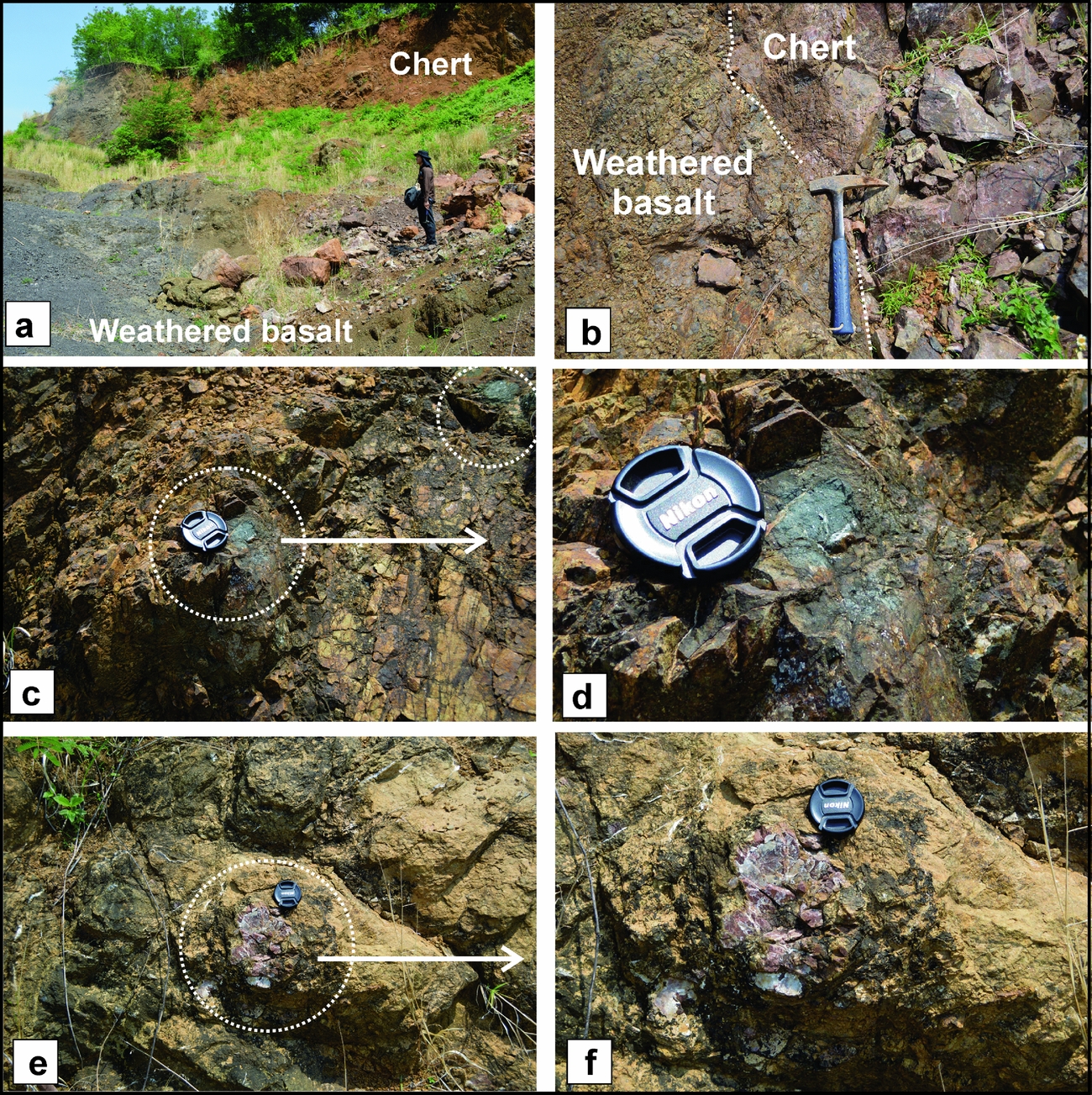
Abandoned and highly weathered quarries (‘old quarries’ herein) in the belt mapped as O Smoet ‘Formation’, within the eastern outskirts of Pailin City, contain strongly deformed basalts and micro-unfossiliferous cherts (Fig. 4, 5). Also present, are chert and basalt blocks within a volcaniclastic matrix (Fig. 5), which may constitute a mélange. However, the rocks in the old quarries differ from the Thung Kabin Mélange of Thailand in lacking a mainly serpentinitic matrix and some of the possible megablocks are in contact. About 1 km further east, a 150 m long, recently active quarry (‘new quarry’ herein) contains less weathered and less deformed, bentonized volcanic ash, volcanic breccia, basalt, dolerite, gabbro, serpentinized probable ultramafic rocks and thinly bedded radiolarian chert (Fig. 6). The rocks, in the new quarry, do not constitute a mélange as the contacts between the units are either non-conformable, intrusive or faulted. Cherts are found in both the eastern and western parts of the quarry (Fig. 6). The rocks in the new quarry form a semi-coherent assemblage which is best termed a dismembered ophiolite. Separate blocks of serpentinite, basalt, chert or basalt with chert have been described on the Thai side of the border, but a variety of mafic volcanic and sedimentary rocks have not been found together in close contact. Further field and laboratory work will define the detailed extent, composition, tectonic setting and ages of these units.
View of Pailin ‘old’ abandoned quarries from ‘new’, recently active, quarry looking west. Hill with mast in distance is Phnom Yat just above the main temple (see Fig. 2a).
Photographs of ‘old’ abandoned quarry. (a) Chert and weathered basalt in ‘old’ quarry; (b) sharp contact between basalt and chert in ‘old’ quarry; (c) a probable part of mélange consisting of clast of mafic volcanic embedded in clastic rocks; (d) enlargement of (c); (e) clast of chert embedded in clastic rocks in probable mélange; (f) magnification of (e). Height of person is 1.75 m, length of hammer is 33 cm and diameter of lens cap is 5.5 cm.
Photographs of ‘new’, recently active, quarry at 12°49′51″N and 102°36′43.44″E. (a) View of quarry looking southeast. Radiolarian samples from western end of quarry – above vehicle; (b) chert and silicified mudstone at western end of quarry, overlying light coloured bentonized volcanic ash; (c) basalt; (d) magnification of serpentinite from (a); (e) thin-bedded chert dipping east; sample bags show collection points; (f) westerly dipping chert at western end and entrance to quarry; bags show radiolarian collection points. Height of person is 1.60 m, length of hammer is 33 cm and diameter of lens cap is 5.5 cm.

3. Material and method
Reconnaissance field work and sampling took place during the summer of 2014 in the west of Cambodia. Seventeen chert samples were collected from the new, active quarry in Pailin (Figs 3, 6). Five samples of chert were collected from the abandoned quarry (Figs 4, 5). All samples were prepared and treated in the Applied Palaeontology and Biostratigraphy Research Unit's laboratory at Mahasarakham University. The chemical treatment method, using hydrofluoric acid, is adapted from Pessagno & Newport (Reference Pessagno and Newport1972). Selected specimens were then picked from dry residues and mounted onto metal stubs for scanning electron microscopy (SEM) in the Faculty of Science, Mahasarakham University.
4. Radiolarian faunas from Pailin, Cambodia
Poorly to moderately well-preserved radiolarians were obtained from three samples including sample numbers QPL1405, QPL1407 and QPL1408 (Fig. 6f). The other samples yield very poorly preserved, recrystallized indeterminable radiolarian tests. However, radiolarians were not found from five samples of chert collected from the old abandoned quarry. Radiolarians from a new, recently active quarry in the east of Pailin, Cambodia are mainly composed of albaillellarians with some latentifistularians and entactinarians. Because of their high abundance and biostratigraphic importance, only albaillellarians are described herein.
4.a. Systematic description of radiolarians
All radiolarian specimens described herein are classified following De Wever et al. (Reference De Wever, Dumitrica, Caulet, Nigrini and Caridroit2001).
Class ACTINOPODA
Subclass RADIOLARIA Müller, Reference Müller1858
Superorder POLYCYSTIDA Ehrenberg Reference Ehrenberg1838, emend. Riedel, Reference Riedel, Harland, Holland, House, Hughes, Reynolds, Rudwick, Satterthwaite, Tarlo and Willey1967
Order ALBAILLELLARIA Deflandre Reference Deflandre and Grasse1953, emend. Holdsworth, Reference Holdsworth1969
Family Albaillellidae Deflandre Reference Deflandre1952, emend. Holdsworth, Reference Holdsworth and Swain1977
Genus Albaillella Deflandre, Reference Deflandre1952; emend. Holdsworth, Reference Holdsworth1966; emend. Ormiston & Lane, Reference Ormiston and Lane1976
Type species. Albaillella paradoxa Deflandre, Reference Deflandre1952
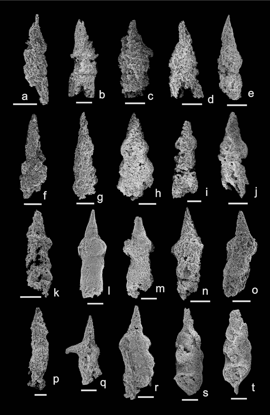
Albaillella sp. Figure 7a–d
Remarks. The illustrated specimens exhibit a shape resembling Albaillella asymmetrica Ishiga & Imoto in the outlines of the apical cone and the pseudoabdomen. The apical cone shows weak segmentation, is distally tapered and changes into a spine (Fig. 7a). The pseudoabdomen is flattened with two asymmetrical wings (Fig. 7c). Unfortunately, our specimens are too poor to classify to species level and are referred to genus only.
Scanning electron micrographs (SEM) of Early Permian radiolarians from Pailin, west of Cambodia. All scale bars = 50 μm. PRC numbers are specimen numbers in the Palaeontological Research Centre of Mahasarakham University. (a–d) Albaillella sp., sample QPL1405 ((a) PRC584, (b) PRC585, (c) PRC586, (d) PRC587); (e–g) Pseudoalbaillella spp., samples QPL1405, QPL1408 ((e) PRC588, (f) PRC589, (g) PRC590); (h–k) Pseudoalbaillella sp. cf. P. lomentaria Ishiga & Imoto, Reference Ishiga and Imoto1980, sample QPL1405 ((h) PRC591, (i) PRC592, (j) PRC593, (k) PRC594); (l–p) Pseudoalbaillella sp. cf. P. elegans Ishiga & Imoto, Reference Ishiga and Imoto1980, samples QPL1405, QPL1408 ((l) PRC595, (m) PRC596, (n) PRC597, (o) PRC598, (p) PRC599); (q–t) Pseudoalbaillella sakmarensis (Kozur, Reference Kozur1981), sample QPL1408 ((q) PRC600, (r) PRC601, (s) PRC602, (t) PRC603).

Range. Early Permian.
Occurrence. Pailin, Cambodia
Family Follicucullidae Ormiston & Babcock, Reference Ormiston and Babcock1979
Genus Pseudoalbaillella Holdsworth & Jones, Reference Holdsworth and Jones1980
Type species. Pseudoalbaillella scalprata Holdsworth & Jones, Reference Holdsworth and Jones1980
Pseudoalbaillella sakmarensis (Kozur, Reference Kozur1981) Figures 7q–t, 8a–c
1981 Parafollicucullus sakmarensis Kozur, pl. 1, figs 1, 3.
1982 Pseudoalbaillella sakmarensis (Kozur); Ishiga, Kito & Imoto, pl. 1, fig. 8.
1985 Pseudoalbaillella sakmarensis (Kozur); Ishida, pl. 1, figs 2, 3.
1989 Pseudoalbaillella cf. sakmarensis (Kozur); Wu & Li, pl. 1, fig. 17.
1989 Pseudoalbaillella sakmarensis (Kozur); Isozaki &Tamura, pl. 1, figs 4, 10.
1994 Pseudoalbaillella sakmarensis (Kozur); Wang, Cheng & Yang, p. 182, pl. 1, figs 9–11.
1997 Pseudoalbaillella sakmarensis (Kozur); Jasin & Ali, pl. 1, fig. 3.
1998 Pseudoalbaillella sakmarensis (Kozur); Xian & Zhang, pl. 2, figs 15–18.
2009 Parafollicucullus sp. cf. P. postsakmarensis; Saesaengseerung et al., p. 128, figs 7.10, 7.11.
Remarks. Apical cone lacking segmentation. Spherical thorax with two asymmetrical wings. The long pseudoabdomen is composed of three segments with the last one strongly curved in the apertural margin.
Range. Early Permian.
Occurrence. Ural, Japan, South China, Malaysia and eastern Thailand.
Pseudoalbaillella scalprata Holdsworth & Jones, Reference Holdsworth and Jones1980 morphotype scalprata Ishiga, Reference Ishiga1983 Figure 8g, h
1980 Pseudoalbaillella scalprata Holdsworth & Jones, p. 284, appendix fig. 1 (A, B).
1980 Pseudoalbaillella sp. cf. Ps. scalprata Holdsworth & Jones; Ishiga & Imoto, pl. 2, figs 4–8.
1982 Pseudoalbaillella scalprata Holdsworth & Jones; Ishiga, Kito & Imoto, pl. 1, figs 11, 12.
1983 Pseudoalbaillella scalprata Holdsworth & Jones morphotype scalprata; Ishiga, pl. 1, figs 1–18.
1984 Pseudoalbaillella sp. aff. Ps. scalprata Holdsworth & Jones; Ishiga et al., pl. 1, figs 4–8.
1985 Pseudoalbaillella scalprata Holdsworth & Jones; Ishida, pl. 1, figs 7–9.
1985 Pseudoalbaillella scalprata Holdsworth & Jones; Sheng & Wang, pl. 2, figs 9–12.
1985 Pseudoalbaillella scalprata Holdsworth & Jones; Yoshida & Murata, pl. 1, figs 8, 9.
1985 Pseudoalbaillella scalprata Holdsworth & Jones; Cornell & Simpson, pl. 1, fig. 5.
1992 Pseudoalbaillella scalprata Holdsworth & Jones; Blome & Reed, figs 10.19–10.21.
1993 Pseudoalbaillella scalprata Holdsworth & Jones; Nazarov & Ormiston, pl. 7, fig. 10.
1994 Pseudoalbaillella scalprata Holdsworth & Jones; Wang, Cheng & Yang, p. 182, pl. 1, figs 20–22.
1996 Pseudoalbaillella scalprata Holdsworth & Jones; Spiller, pl. 3, figs 6, 7.
1998 Pseudoalbaillella scalprata Holdsworth & Jones; Sashida et al., p. 13, figs 11–11, 12, 13.
2006 Pseudoalbaillella scalprata Holdsworth & Jones; Shimakawa & Yao, pl. 1, figs 16–18.
2009 Pseudoalbaillella scalprata Holdsworth & Jones; Saesaengseerung et al., figs 7.28, 7.29.
2011 Pseudoalbaillella scalprata Holdsworth & Jones; Jasin & Harun, pl. 4, fig. 4.
2011 Pseudoalbaillella scalprata Holdsworth & Jones; Xie et al., p. 214, figs 2A, S.
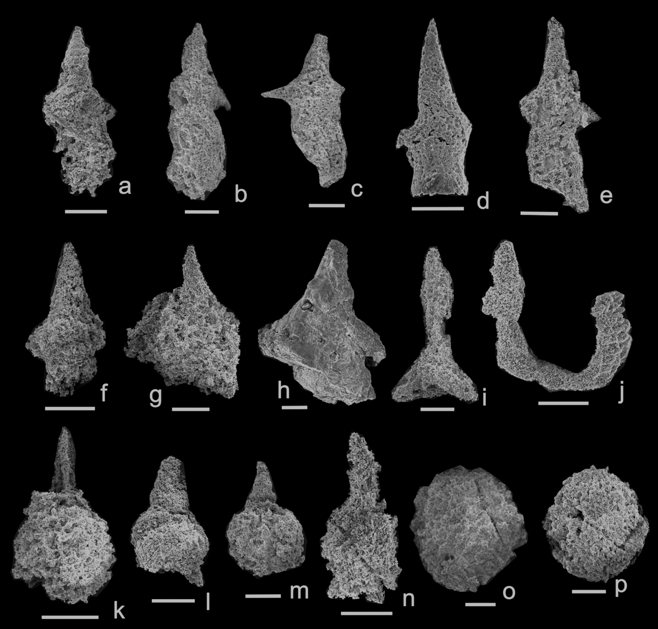
Scanning electron micrographs (SEM) of Early Permian radiolarians from Pailin, Cambodia. All scale bars = 50 μm. PRC numbers are specimen numbers in the Palaeontological Research Centre of Mahasarakham University. (a–c) Pseudoalbaillella sakmarensis (Kozur, Reference Kozur1981), samples QPL1405, QPL1408 ((a) PRC604, (b) PRC605, (c) PRC606); (d–f) Pseudoalbaillella sp. cf. P. simplex Ishiga & Imoto, Reference Ishiga and Imoto1980, samples QPL1405, QPL1408 ((d) PRC607, (e) PRC608, (f) PRC609); (g, h) Pseudoalbaillella scalprata Holdsworth & Jones, Reference Holdsworth and Jones1980 morphotype scalprata Ishiga, Reference Ishiga1983, samples QPL1405, QPL1408 ((g) PRC610, (h) PRC611); (i) Latentifistularia gen. et sp. indet., sample QPL1407 (PRC612); (j) Pseudoalbaillella u-forma Holdsworth & Jones, Reference Holdsworth and Jones1980, morphotype II (Ishiga, Imoto, Yoshida & Tanabe, Reference Ishiga, Imoto, Yoshida and Tanabe1984), sample QPL1408 (PRC613); (k) Trilonche? sp. sample QPL1405 (PRC614); (l–n) Pseudoalbaillella spp., samples QPL1405, QPL1407 ((l) PRC615, (m) PRC616, (n) PRC617); (o, p) Entactinaria gen. et sp. indet, samples QPL1405, QPL1408 ((o) PRC618, (p) PRC619).

Remarks. The illustrated specimens of Pseudoalbaillella scalprata by Ishiga (Reference Ishiga1983) seem to show rather wide variation in the length of the apical horn and pseudoabdomen and the angle between the two shoulders. Our specimens are characterized by the diagnostic features of this species in having a small and slightly curved apical horn. The pseudothorax is sub-globular with two slightly flattened wings. The pseudoabdomen with two flaps is extending downwards.
Range. Early–Middle Permian.
Occurrence. Japan, West Texas, Oregon, China, peninsular Malaysia, northern, eastern and NE Thailand.
Pseudoalbaillella sp. cf. P. simplex Ishiga & Imoto, Reference Ishiga and Imoto1980 Figure 8d–f
1980 Pseudoalbaillella simplex Ishiga & Imoto, pl. 1, figs 13–18.
1982 Pseudoalbaillella simplex Ishiga & Imoto; Hattori & Yoshimaru, pl. 1, fig. 2.
1985 Pseudoalbaillella simplex Ishiga & Imoto; Ling, Forsythe & Douglass, fig. 3L, M.
1984 Pseudoalbaillella simplex Ishiga & Imoto; Ishiga et al., pl. 1, figs 17–22.
1989 Pseudoalbaillella simplex Ishiga & Imoto; Isozaki & Tamura, pl. 4, figs 11, 12.
1994 Pseudoalbaillella simplex Ishiga & Imoto; Wang, Cheng & Yang, p. 183, pl. 1, figs 3, 4, 19.
2002 Pseudoalbaillella simplex Ishiga & Imoto; Sashida & Salyapongse, p. 696, fig. 3.3.
2008 Pseudoalbaillella simplex Ishiga & Imoto; Kurihara & Kametaka, p. 537, fig. 5.9.
2011 Pseudoalbaillella simplex Ishiga & Imoto; Xie et al., p. 215, fig. 2I, J.
2016 Pseudoalbaillella simplex Ishiga & Imoto; Shi et al., p. 5, fig. 4.5.
Remarks. Apical cone is long without segmentation and the ventral side is slightly curved. Pseudothorax is weakly inflated with two small wings. The constriction between the pseudothorax and the pseudoabdomen is weak. Although these specimens are broken, they are comparable to the type specimen (Ishiga & Imoto, Reference Ishiga and Imoto1980, pl. 1, fig. 18) so we have assigned them to Pseudoalbaillella sp. cf. P. simplex.
Range. Early Permian.
Occurrence. South China, SW Japan and Chile.
Pseudoalbaillella u-forma Holdsworth & Jones, Reference Holdsworth and Jones1980, morphotype II (Ishiga et al. Reference Ishiga, Imoto, Yoshida and Tanabe1984)
Figure 8j
1980 Pseudoalbaillella u-forma Ishiga & Imoto, pl. 1, figs 6–8.
1982 Pseudoalbaillella u-forma Ishiga & Imoto; Ishiga, Kito & Imoto, pl. 1, fig. 1.
1984 Pseudoalbaillella u-forma Holdsworth & Jones morphotype II; Ishiga et al., pl. 1, fig. 5.
2006 Pseudoalbaillella u-forma Holdsworth & Jones morphotype II; Shimakawa & Yao, pl. 1, figs 10–11.
2009 Parafollicucullus u-formus (Holdsworth & Jones) m II; Saesaengseerung et al., figs 7.6, 7.7.
Remarks. Although the illustrated specimen is poorly preserved and broken, it closely resembles Pseudoalbaillella u-forma (Holdsworth & Jones) morphotype II, in having a slender apical cone, small pseudothorax and a U-shaped pseudoabdomen.
Range. Early Permian.
Occurrence. South China, Japan, Alaska (United States) and eastern Thailand.
Pseudoalbaillella sp. cf. P. elegans Ishiga & Imoto, Reference Ishiga and Imoto1980
Figure 7l–p
1980 Pseudoalbaillella elegans Ishiga & Imoto, p. 31, pl. 1, figs 9–12.
1982 Pseudoalbaillella elegans Ishiga & Imoto; Ishiga, Kito & Imoto, pl. 1, figs 2, 3.
1987 Pseudoalbaillella elegans Ishiga & Imoto; Ling & Forsythe, p. 257, pl. 1, fig. 9.
1989 Pseudoalbaillella elegans Ishiga & Imoto; Isozaki & Tamura, pl. 4, figs 7–9.
1993 Pseudoalbaillella elegans Ishiga & Imoto; Sashida et al., figs 6, 1–4.
1994 Pseudoalbaillella elegans Ishiga & Imoto; Wang, Cheng & Yang, pp. 179, 180, pl. 1, figs 7, 8.
1998 Pseudoalbaillella elegans Ishiga & Imoto; Sashida et al., p. 11, figs 11, 12–15.
2011 Pseudoalbaillella elegans Ishiga & Imoto; Xie et al., p. 210, figs 2U, V.
1994 Pseudoalbaillella elegans Ishiga & Imoto; Pseudoalbaillella sp. aff. P. elegans Ishiga & Imoto; Wu, Xian & Kuang, pl. 2, fig. 6.
1996 Pseudoalbaillella elegans Ishiga & Imoto; Spiller, pl. 4, figs 5, 6.
2009 Pseudoalbaillella sp. cf. P. elegans Ishiga & Imoto; Saesaengseerung et al., p. 129, figs 7.12, 7.13.
2016 Pseudoalbaillella elegans Ishiga & Imoto; Shi et al., p. 5, fig. 4.11.
Remarks. Apical cone is without segmentation with no sinuosity in the shell. However, the pseudoabdomen of our specimens is shorter than the type specimens and they may be broken. The pseudothorax is also larger than in the type specimens (e.g. Fig. 7l, o).
Range. Early Permian.
Occurrence. South China, Japan, Chile, peninsular Malaysia and northern, eastern and NE Thailand.
Pseudoalbaillella sp. cf. P. lomentaria Ishiga & Imoto, Reference Ishiga and Imoto1980
Figure 7h–k
1980 Pseudoalbaillella lomentaria Ishiga & Imoto, p. 32, pl. 2, figs 9–15.
1992 Pseudoalbaillella lomentaria Ishiga & Imoto; Kuwahara, pl. 2, fig. 14.
1992 Pseudoalbaillella sp. cf. P. lomentaria Ishiga & Imoto; Blome & Reed, pl. 10, figs 7, 8.
1993 Pseudoalbaillella lomentaria Ishiga & Imoto; Sashida et al., figs 6–5, 6.
1994 Pseudoalbaillella lomentaria Ishiga & Imoto; Wang, Cheng & Yang, p. 181, pl. 1, figs 12, 13.
1994 Pseudoalbaillella lomentaria Ishiga & Imoto; Wu, Xian & Kuang, pl. 2, fig. 8.
1995 Pseudoalbaillella lomentaria Ishiga & Imoto; Sashida, p. 39, figs 1–18, 19.
1997 Pseudoalbaillella lomentaria Ishiga & Imoto; Jasin & Ali, p. 331, pl. 1, fig. 1.
1998 Pseudoalbaillella lomentaria Ishiga & Imoto; Sashida et al., p. 13, figs 11–16–18.
2002 Pseudoalbaillella lomentaria Ishiga & Imoto; Sashida & Salyapongse, p. 696, figs 3.4, 3.5.
2005 Pseudoalbaillella aff. lomentaria Ishiga & Imoto; Suzuki et al., p. 696, figs 7.1–7.6.
2009 Parafollicucullus lomentarius (Ishiga & Imoto); Saesaengseerung et al., p. 127, fig. 7.14.
2016 Pseudoalbaillella lomentaria Ishiga & Imoto; Shi et al., p. 5, fig. 4.12.
Remarks. The examined specimens are similar to P. lomentaria in having a slightly curved apical cone, spherical pseudothorax and three-segmented pseudoabdomens. But our specimens do not possess a pair of flattened wings.
Range. Early Permian.
Occurrence. South China, Japan, Chile, North America, Malaysia, Far East Russia and northern, eastern and NE Thailand.
Pseudoalbaillella spp.
Figures 7e–g, 8l–n
Remarks. The specimens are not well preserved. The test consists of a relatively large cone with an apical cone. The pseudothorax is inflated and spherical in outline. The pseudoabdomen is inflated and cylindrical. There is a constriction between the pseudoabdomen and the pseudothorax.
Range. Early Permian
Occurrence. Pailin, Cambodia.
4.b. Age assignment of the Pailin radiolarian fauna
More than eight species and three undetermined radiolarians (Figs 7, 8) are reported from Pailin and comprise: Pseudoalbaillella sakmarensis (Kozur, Reference Kozur1981); Pseudoalbaillella scalprata morphotype scalprata Ishiga, Reference Ishiga1983; Pseudoalbaillella sp. cf. P. simplex Ishiga & Imoto Reference Ishiga and Imoto1980; Pseudoalbaillella u-forma morphotype II (Ishiga et al. Reference Ishiga, Imoto, Yoshida and Tanabe1984); Pseudoalbaillella sp. cf. P. elegans Ishiga & Imoto, Reference Ishiga and Imoto1980; Pseudoalbaillella sp. cf. P. lomentaria Ishiga & Imoto, Reference Ishiga and Imoto1980; Albaillella sp.; Pseudoalbaillella spp.; Trilonche? sp.; Latentifistularia gen. et sp. indet.; and Entactinaria gen. et sp. indet.
Among this radiolarian fauna, albaillellarians are most abundant. The biostratigraphically important species are Pseudoalbaillella sakmarensis, Pseudoalbaillella scalprata m. scalprata, Pseudoalbaillella simplex and Pseudoalbaillella u-forma m. II, Pseudoalbaillella sp. cf. P. elegans and Pseudoalbaillella sp. cf. P. lomentaria. They have a similarity with faunas reported from Lower Permian strata in Japan (Ishiga, Reference Ishiga1982, Reference Ishiga1986, Reference Ishiga, Ichikawa, Mizutani, Hara, Hada and Yao1990; Sashida, Reference Sashida1995), West Texas (Cornell & Simpson, Reference Cornell and Simpson1985), Cis–Ural (Kozur & Mostler, Reference Kozur and Mostler1989), Oregon, United States (Blome & Reed, Reference Blome and Reed1992), South China (Wang, Cheng & Yang, Reference Wang, Cheng and Yang1994; Shimakawa & Yao, Reference Shimakawa and Yao2006; Wang & Yang, Reference Wang and Yang2011), Malaysia (Jasin & Ali, Reference Jasin and Ali1997; Jasin, Reference Jasin2008), Far East Russia (Suzuki et al. Reference Suzuki, Kojima, Kano, Yamakita, Misaki, Ehiro, Otoh, Kurihara and Aoyama2005) and central, eastern and northeastern Thailand (Sashida & Nikornsri, Reference Sashida, Nikornsri, Dheeradilok, Hinthong, Chaodumrong, Putthapiban, Tansathien, Utha–aroon, Sattayarak, Nuchanong and Techawan1997; Sashida et al. Reference Sashida, Igo, Adachi, Ueno, Nakornsri and Sardsud1998; Sashida & Salyapongse, Reference Sashida and Salyapongse2002; Saesaengseerung et al. Reference Saesaengseerung, Agematsu, Sashida and Sardsud2009; Burrett et al. Reference Burrett, Udchachon, Thassanapak and Chitnarin2015). Pseudoalbaillella u-forma m. II, Pseudoalbaillella elegans and Pseudoalbaillella simplex are the representative species of the Pseudoalbaillella u-forma m. II Assemblage Zone (early to middle Wolfcampian) of Ishiga (Reference Ishiga1986, Reference Ishiga, Ichikawa, Mizutani, Hara, Hada and Yao1990), which can be correlated with the Pseudoalbaillella simplex Assemblage of Sashida & Salyapongse (Reference Sashida and Salyapongse2002), Pseudoalbaillella u-forma m. II Zone of Shimakawa & Yao (Reference Shimakawa and Yao2006) and Pseudoalbaillella u-forma – P. elegans Assemblage Zone of Wang & Yang (Reference Wang and Yang2011). Those zones correspond with the Lower Permian (Asselian). Pseudoalbaillella lomentaria, Pseudoalbaillella sakmarensis and Pseudoalbaillella scalprata m. scalprata are indicative of the Pseudoalbaillella lomentaria Assemblage Zone (middle to late Wolfcampian) of Ishiga (Reference Ishiga1986, Reference Ishiga, Ichikawa, Mizutani, Hara, Hada and Yao1990), which is correlated to the Pseudoalbaillella lomentaria Assemblage of Sashida & Salyapongse (Reference Sashida and Salyapongse2002), Pseudoalbaillella lomentaria Zone of Shimakawa & Yao (Reference Shimakawa and Yao2006) and Pseudoalbaillella lomentaria – P. sakmarensis Assemblage Zone of Wang & Yang (Reference Wang and Yang2011). These zones are Lower Permian ranging in age from the Asselian to the Sakmarian, although Zhao et al. (Reference Zhao, Huang, Zhang, Yang, Chen and Xiong2016) put the P. lomentaria Zone in or up to include the lower Artinskian. In the Chantaburi area along the Sa Kaeo Suture zone, eastern Thailand, Saesaengseerung et al. (Reference Saesaengseerung, Agematsu, Sashida and Sardsud2009) reported the co-occurrence of conodonts (Streptognathodus constrictus) that also indicate an Asselian–Sakmarian age. It can be suggested that some taxa probably range up to late Early Permian time or even existed in early Middle Permian (Roadian) time such as P. lomentaria, P. simplex, P. scalprata and P. elegans reported from Hubei, China (Shi et al. Reference Shi, Feng, Shen, Ito and Chen2016).
The radiolarian faunas in the samples from Pailin, Cambodia correspond to the radiolarian zonal faunas of the Pseudoalbaillella u-forma m. II Assemblage Zone to the Pseudoalbaillella lomentaria Assemblage Zone of Ishiga (Reference Ishiga1986, Reference Ishiga, Ichikawa, Mizutani, Hara, Hada and Yao1990), which indicates an Early Permian (Asselian–Sakmarian) age.
5. Discussion
At Pailin in western Cambodia, an E–W-trending, 1.5 to 2 km wide, 20 km long belt of ophiolitic rocks including Lower Permian radiolarian cherts and volcanic rocks is contiguous with the Lower Permian mélange of the Sa Kaeo Suture in Thailand and indicates that the suture extends eastwards into Cambodia (Fig. 9). Mouret (Reference Mouret, Angsuwathana, Wongwanich, Tansathein, Wongsomsak and Tulyatid1994) suggested an E–W trend for an ultramafic belt, near Pursat (Fig. 9), which he termed the Pursat Line.
Speculative diagrammatic map showing possible trend of the Sa Kaeo–Pailin Suture eastwards and then southwards along the Pursat–Kampot Fold Belt in Cambodia, based mainly on information on the distribution of ultramafic and mafic igneous rocks and cherts in Gubler (Reference Gubler1935). Other Cambodian data are from United Nations (1993). Thailand data are from Sangsomphong et al. (Reference Sangsomphong, Tulyatid, Thitimakorn and Charusiri2013) and Ridd & Morley (Reference Ridd and Morley2011) and DMR geological maps. Gravity lows and ‘basement’ highs in Cambodia are from Te Duong Tara (Reference Tara2006).
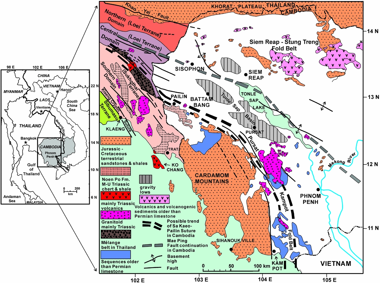
Mentions of chert, basalt and gabbro surrounding the Jurassic–Cretaceous terrestrial sedimentary sequence of the Cardamom Mountains (Gubler, Reference Gubler1935; Dottin & Zinszner, Reference Dottin and Zinszner1972) suggest that the suture may also follow the general trend of the Pursat–Kampot Fold Belt towards the south (Fig. 9) as suggested by Khin Zaw et al. (Reference Zaw, Meffre, Lai, Burrett, Santosh, Graham, Manaka, Salam, Kamvong and Cromie2014) (Fig. 1).
The gravity lows that help define the Tonle Sap Basin to the south of Tonle Sap Lake in Cambodia (Te Duong Tara, Reference Tara2006) align with the central geophysical domain of Sangsomphong et al. (Reference Sangsomphong, Tulyatid, Thitimakorn and Charusiri2013) in Thailand. This also suggests an easterly rather than a south–southeasterly alignment of the suture within Cambodia (Fig. 9).
Morley et al. (Reference Morley, Ampaiwan, Thanudamrong, Kuenphan and Warren2013) constructed a pre-Cenozoic palinspastic reconstruction for Cambodia and eastern Thailand by translation and rotation of a northern Indochina block around the Cenozoic Mae Ping Fault. A slightly smaller rotation could explain both the initiation and deformation of the Tonle Sap Basin to the south of Tonle Sap Lake (Fig. 9). Speculatively, an Early Permian volcanic arc extended eastwards from Sisophon to follow the Siem Reap – Stung Treng Fold Belt (Fig. 9) (the Rovieng Line of Mouret, Reference Mouret, Angsuwathana, Wongwanich, Tansathein, Wongsomsak and Tulyatid1994), and the ophiolitic/mélange assemblages at Pailin may have formed within a back-arc basin sphenochasm. The volcanic rocks at Sisophon were then conformably overlain by platform carbonates of Middle Permian age and deformed during phases of the Triassic Indosinian orogeny (Arboit et al. Reference Arboit, Collins, Morley, King and Amrouch2016). Arc magmatism continued well into Late Triassic time along the Sukhothai Terrane in Thailand until its collision with the Loei Terrane during Norian time.
6. Conclusions
The mélange–ophiolitic rocks from Pailin occur in an E–W-trending belt and are a continuation of the Sa Kaeo Suture of eastern Thailand. The first illustrated and identified Cambodian radiolarians are described herein from the Pailin chert and are the same Early Permian age as those from the Sa Kaeo Suture. The E–W trend of the Pailin ophiolitic/mélange rocks and their contacts with the metamorphic rocks of the largely amphibolitic Pailin Crystalline Complex, to the north, suggest that the main suture separating the Loei Terrane from the volcanic arc Sukhothai Terrane follows the northern margin of the Jurassic–Cretaceous age terrestrial sandstones of the Cardamom Mountains. Speculatively, the suture (Fig. 9) may then follow the eastern margin of the Cardamom Mountains southwards along the geologically very poorly known Pursat–Kampot Fold Belt.
Acknowledgements
The project was supported by Mahasarakham University and the National Research Council of Thailand. We appreciate the help of Mr Sa-ngaun Choochang, Mr Komkrit Uttarawiset and other colleagues in Cambodia. We thank Drs Sangad Bunopas, Sirot Salypongse and Bob Findlay for their help in Thailand. Drs Tsuyoshi Ito and Zhong-Qiang Chen provided thorough and very helpful reviews.