Public architecture is one of the key features of early complex societies, as the massive mobilization of resources required for these projects prevented smaller-scale societies from undertaking them. In the Americas and elsewhere, public architecture took different forms such as mounds, platforms, ditches, palisades, and causeways (Dillehay Reference Dillehay1992a; Iriarte Reference Iriarte2006; Lesure and Blake Reference Lesure and Blake2002; Spencer and Redmond Reference Spencer and Redmond1998). In this paper we discuss, from an archaeological and pedological perspective, a mound-and-platform complex discovered on Mocha Island (southern Chile) and compare it with similar sites on mainland southern Chile (Dillehay Reference Dillehay1986, Reference Dillehay2007, ed. Reference Dillehay and Dillehay2014). Our aim is to shed light on the convergent and divergent characteristics of the indigenous communities in this region since ~AD 1000. This paper also endeavors to establish a methodological framework for studying the architectural features of public complexes. First we will introduce the geographical and social context of southern Chile and Mocha Island. We then describe Dillehay's groundbreaking work on mound building in the Purén-Lumaco area. This is followed by the results of our research, a discussion of these results, and our conclusions.
Southern Chile and Mocha Island: Its Territory and People
Geographical Setting
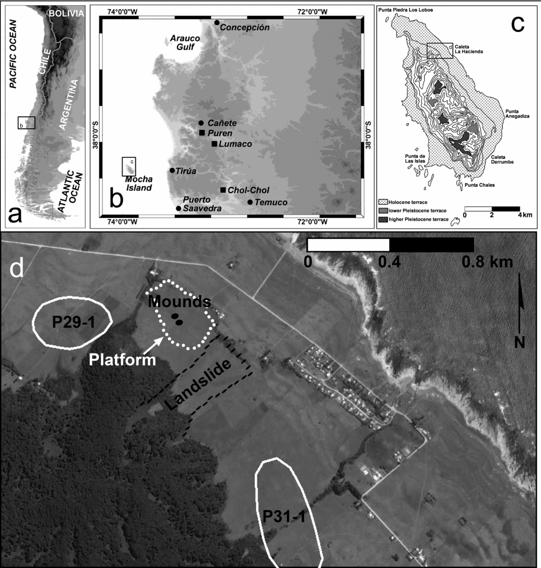
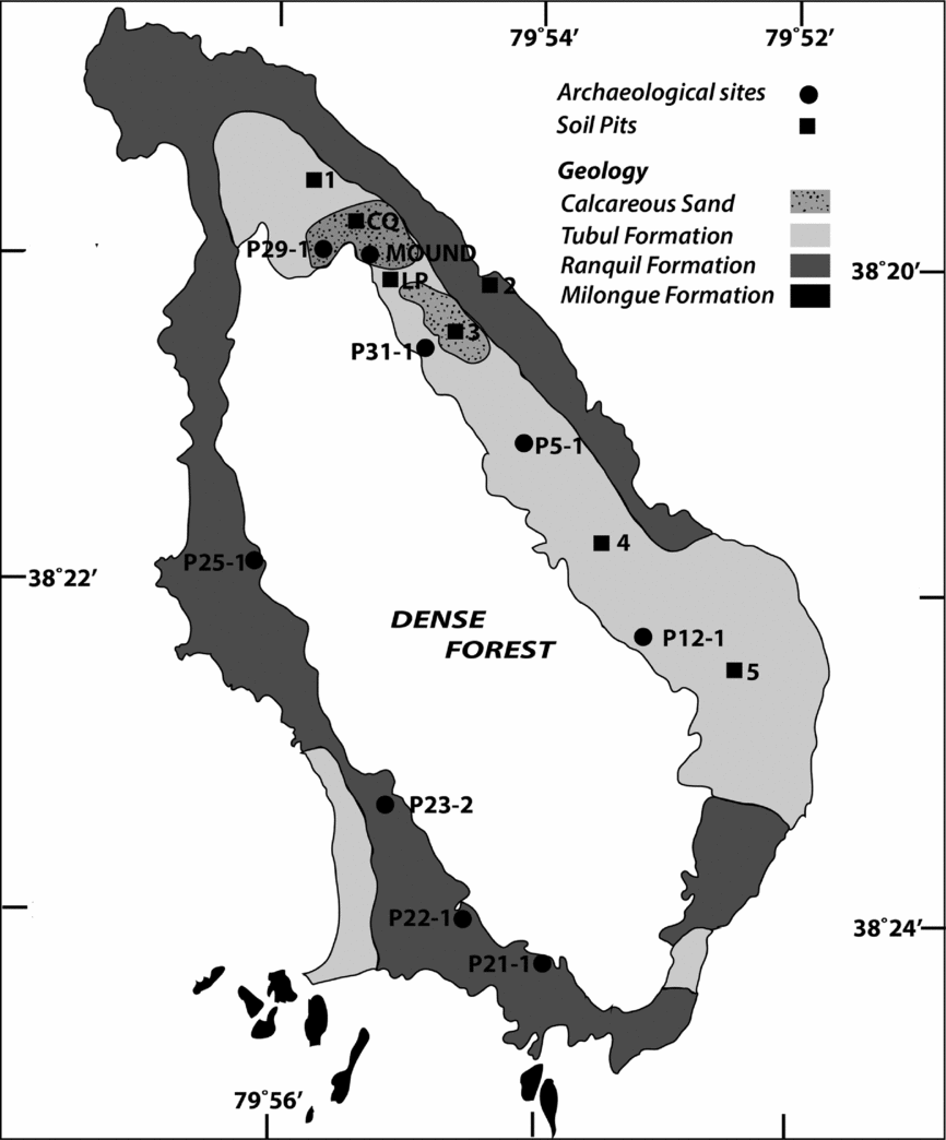
Mocha Island is located in the South Pacific Ocean at 38°22’ S, 30 km off the coast of southern Chile (Figure 1a). It is composed of abrupt escarpments that separate elevated Pleistocene marine abrasion platforms from a Holocene marine abrasion terrace (Figure 1c). The Holocene marine terrace surrounds the entire island and consists of a wave-cut platform directly abraded into the bedrock, which corresponds mainly to the Ranquil (Miocene) and Tubul (Pliocene) formations (Tavera and Veyl Reference Tavera and Veyl1958), both of marine origin (Figure 2). A series of 18 strandlines formed by sand, gravel, and shell deposits have developed over the last 6,000 years due to tectonic uplift, causing a shoreline retreat of ~38 m during that period (Nelson and Manley Reference Nelson and Manley1992). Due to the steep terrain and dense forest of the central ridge, current human activity and settlements are located on the Holocene terrace, as are all archeological sites found on the island to date.
(a) Southern South America, with the location of southern Chile. (b) Southern Chile, with the location of Mocha Island, modern cities (black dots), and archaeological districts mentioned in the text (black squares). (c) Mocha Island's main geomorphological features and inset of mound location. (d) Mocha Island architectural complex (mounds and platform) and nearby archaeological domestic sites (Google Earth image).

Mocha Island archaeological sites (black dots) and soil pit observations (black squares). Rocks that outcrop at the Holocene level terrace (after Gajardo Reference Gajardo1973) and that served as parent material for the two main soil types present on the island are indicated.

Human Trajectories
Despite the fact that southern Chile has one of the longest records of human occupation in the Americas (Monte Verde, ~14500 cal BP [Dillehay Reference Dillehay1997; Dillehay et al. Reference Dillehay, Ramírez, Pino, Collins, Rossen and Pino-Navarro2008]), the first period of occupation on Mocha Island is dated to a brief span of time as recently as around 3400 cal BP (~1450 cal BC), after which the island appears to remain unoccupied for the next 1,500 years (Campbell Reference Campbell2015a; Quiroz et al. Reference Quiroz, Vásquez and Sánchez2000).
By ~1850 cal BP (~100 cal AD), the first evidence of ceramics appears in southern Chile (Adán et al. Reference Adán, Mera, Navarro, Quiroz, Campbell, Sánchez, Falabella, Aldunate, Uribe and Sanhueza2016; Campbell and Quiroz Reference Campbell and Quiroz2015), although the first centuries of this phenomenon (~1850–1550 cal BP [~100–400 cal AD]) are still not fully defined. It is followed by the Early Ceramic Period (1550–950 cal BP [400–1000 cal AD]), during which the Pitrén Complex is the predominant culture-historical unit for all of southern Chile (Adán and Mera Reference Adán and Mera2011; Aldunate Reference Aldunate, Hidalgo, Schiappacasse, Niemeyer, Aldunate and Solimano1989; Mera Reference Mera2014). In the mainland, a remarkable shift occurs from the small early Pitrén cemeteries (no more than 10 graves) to larger ones in the late Pitrén (up to 50 graves), likely denoting larger, more sedentary, coresidential groups. These later graves, in contrast to the undifferentiated early burials, present varying quantities of ceramic vessels and have even yielded unusual artifacts such as metallic adornments and alpaca (Vicugna pacos) wool textiles. This evidence could indicate an emergent level of social differentiation occurring within this society (Adán and Mera Reference Adán and Mera2011; Mera Reference Mera2014; Mera et al. Reference Mera, Mille, Munita and Figueroa2015; Ocampo et al. Reference Ocampo, Mera and Rivas2003).
In the case of Mocha Island, ceramics also appear around 1850 cal BP (~100 cal AD), marking the starting point of its second human occupation. Here the Pitrén Complex is represented by isolated findings and a few archaeological stratigraphic components. An effective and permanent colonization of Mocha Island can be identified dating to around 950 cal BP (~1000 cal AD; Campbell Reference Campbell2015a), which lasted into the ethnohistorical period.
The Pitrén Complex was followed, in the northern section of southern Chile (Mocha Island included), by the El Vergel Complex which is the prevailing culture-historical unit for this region during the Late Ceramic Period (950--400 cal BP [1000--1550 cal AD]). It is important to note that the Pitrén-El Vergel transition does not seem to imply a population replacement, but rather a significant change in the material assemblages that characterize each complex – primarily, ceramic decoration and funerary practices (Adán et al. Reference Adán, Mera, Uribe and Alvarado2005; Aldunate Reference Aldunate2005; Bahamondes Reference Bahamondes2010; Dillehay Reference Dillehay1990a; Massone Reference Massone2005). Additionally, there is a diversification of burial patterns (direct burial, dugout trunks, stone slab cists, urns, and mounds; Aldunate Reference Aldunate, Hidalgo, Schiappacasse, Niemeyer, Aldunate and Solimano1989; Bullock Reference Bullock1970; Dillehay Reference Dillehay1986), the development of a widespread metal-working tradition (Campbell Reference Campbell2005; Campbell et al. Reference Campbell, Teresa Plaza and Figueroa2015), and the earliest manifestations of public architecture (earthen mounds and platforms; Dillehay Reference Dillehay2007).
In terms of subsistence, there is a clear and greater reliance on cultivated resources such as quinoa (Chenopodium quinoa), maize (Zea mays), beans (Phaseolus vulgaris), squash (Cucurbita sp.), and cheatgrass (Bromus sp.), combined with wild ones such as strawberry (Fragaria chiloensis), maqui (Aristotelia chilensis), and berries (Rubus sp.), among others (Bonzani Reference Bonzani and Dillehay2014; Delgado Reference Delgado2016; Dillehay et al. Reference Dillehay, Pino, Bonzani, Silva, Wallner and Le Quesne2007; Godoy Reference Godoy2016; Iriarte Reference Iriarte and Dillehay2014; Massone et al. Reference Massone, Silva, Labarca and Haberle2012; Roa Reference Roa2016; Roa et al. Reference Roa, Silva and Campbell2015; Sánchez et al. Reference Sánchez, Quiroz and Massone2004; Silva Reference Silva2010, Reference Silva and Dillehay2014). In addition, there is evidence of hunting and fishing practices and likely raising of camelids (Lama sp.). Also, the El Vergel Complex residential sites are the most ubiquitous and discernible in all of southern Chile. On Mocha Island, in particular, these domestic areas range from 4 to 15 ha in size and present deep (80 to 150 cm) and rich deposits (Campbell Reference Campbell2011, Reference Campbell2015b; Quiroz and Sánchez Reference Quiroz and Sánchez2005; Sánchez Reference Sánchez1997).
Taken together, all of the above evidence is indicative of a much more sedentary lifestyle, and a very probable increase in population. In sociopolitical terms, the El Vergel Complex seems to correspond to several small political units or polities, whose descriptions plausibly fit somewhere between transegalitarian societies and simple chiefdoms (Bogucki Reference Bogucki1999), marking a significant increase in social complexity from its Pitrén predecessor. The slight evidence of wealth differentiation vis-à-vis the ethnohistorical record helps propose a phenomenon of social differentiation based more on ideological aspects, rather than direct economic control (Campbell Reference Campbell2011; Dillehay Reference Dillehay2007).
The southern Chile Late Ceramic Period groups faced the arrival of Europeans around AD 1550; the collective but vague name they used to refer to themselves was “reche”: “the authentic people” (Adán Reference Adán2014; Boccara Reference Boccara2007; Sauer Reference Sauer2015). After 50 years of occupation of this area, Europeans were permanently driven out to the north of the Biobio-Laja rivers. An independent indigenous country emerged in 1604 and lasted until 1882, when it was conquered by the Chilean state. The society during the ethnohistorical period, in contrast to the prehistoric one, is marked by livestock raising, raiding, and a trading economy, as well as the consolidation or reinforcement of a chiefdom structure in certain sectors of southern Chile (Bengoa Reference Bengoa2003; Boccara Reference Boccara2007; Dillehay Reference Dillehay2007; Zavala Reference Zavala2008). By the mid-eighteenth century, a new ethnic identity had emerged from “reche” and was clearly consolidated as “Mapuche.” Finally, the integration of the Mapuche people into Chile during the late nineteenth century, although resulting in the dissolution of their political autonomy and most of their social structure, did not lead to the disappearance of their traditions and ideological world.
In contrast to the mainland, Mocha Island during the sixteenth and seventeenth centuries was never occupied by Europeans. Still, its indigenous population was intermittently visited by European explorers who traded with the islanders and/or raided them (Quiroz and Olivares Reference Quiroz, Carlos Olivares, Quiroz and Sánchez1997). This situation continued until Spanish authorities forcibly transferred the island's population to the mainland in AD 1685–1687, bringing its second human occupation to an abrupt end (Goicovich and Quiroz Reference Goicovich and Quiroz2008; Quiroz Reference Quiroz1994). After this, Mocha Island remained unoccupied for the next 160 years. In the 1840s, a third human occupation began by Chilean farmers (Pizarro Reference Pizarro1990) who are the forebears of most of the current population. They implemented an economy based on livestock and low-scale nonmechanized agriculture.
Mounds in Southern Chile: The Case of Purén-Lumaco
In southern Chile, anthropogenic mounds and platforms have been very recently recognized as a feature of the Late Ceramic Period (AD 1000–1550) and Reche-Mapuche groups (AD 1550–present). This has mostly been due to the efforts of Dillehay (Reference Dillehay1986, Reference Dillehay1990b, Reference Dillehay and Lange1992b, Reference Dillehay and Politis1992c, Reference Dillehay and Dillehay1995a, Reference Dillehay1995b, Reference Dillehay, Durán and Bracco1999, Reference Dillehay and Boccara2002, Reference Dillehay2006, Reference Dillehay2007, ed. Reference Dillehay2014; Dillehay and Saavedra Reference Dillehay and Saavedra2003, Reference Dillehay and Saavedra2010; Seguel et al. Reference Seguel, Pino and Dillehay2005), although previous indications can be found in ethnohistorical sources (Molina Reference Molina1795:90; Nuńẽz de Pineda Reference Nuńớz de Pineda y Bascunãń2001[1673]:498–502) and archaeological works (Gordon et al. 1972–Reference Gordon, Madrid and Monleón1973). In addition, there are also small burial tumuli in southern Chile (Dillehay Reference Dillehay2007:91–92, Reference Dillehay and Dillehay2014:16; Latcham Reference Latcham1916:138–140, Reference Latcham1924:524– 525, Reference Latcham1928:207) that should be distinguished from the abovementioned features; these tumuli did not reach the spatial scale or convey the same ritual and political importance as the mounds and platforms did for prehistoric, ethnohistorical, and ethnographic indigenous groups.
According to Dillehay (Reference Dillehay2007:37), mounds are present in different areas of southern Chile. Purén-Lumaco has the largest number of mounds at over 300; it is also where they are still used, constructed, and incorporated in Mapuche life. These mounds range between 5 and 50 m in diameter and 1 and 18 m in height, and most are clustered in 9- to 12-mound complexes or rehuekuel (Dillehay Reference Dillehay2007:17, 94, 279–281). Purén-Lumaco has an area of about 250 km2, and based on Dillehay's calculations (2007:305–306, 311), it could hold a population of 10,000 to 30,000 in the late prehistoric period (AD 1000–1550) and into AD 1800.
Dillehay's ethnographic research has recovered a variety of concepts related to the mounds (2007:16–22, 159). First, the name for mound in the Mapudungun language is kuel, which means “a socially built mound where ancestral spirits reside, important people are occasionally buried, and public rituals are performed,” while ñichi is “the culturally leveled surface, or hilltop platform, on which mounds are erected.” An associated term is rehuekuel, which refers to “sacred knolls and hilltops that are artificially leveled, where one or several kuel are located and where large scale nguillatun (fertility) and other public ceremonies are sponsored by multiple patrilineages.” These rehuekuel then are “associated with old nguillatun and palín (ball-game) fields and sacred altars (llangi-llangi).” Finally, reñinmapu are “the artificially prepared soil layers that make up the mounds,” and kueltun refers to “the ritual act of capping the kuel with individual soil layers that are offerings to the ancestors and deities.”
Dillehay proposes that mound building in Purén-Lumaco and elsewhere in southern Chile “was related to population growth, social emulation, competitive feasting, and differential power relations between lineages in highly fertile, circumscribed valleys” (Dillehay Reference Dillehay2007:34). In turn, “the absence of archaeological kuel in some areas suggests that local societies never activated a necessary and sufficient level of social stratification and complexity to develop mound building” (Dillehay Reference Dillehay2007:312). For the same reason, “those populations in the region not having built and worshipped mounds, generally did and do not exhibit the same kinds of social organization and military success [than mound-building populations]” (Dillehay Reference Dillehay2007:22).
The areas where mounds are built correspond to “spurs, crests, or promontories, usually at their highest point or at a unique angle that visually sets them apart and visibly contrasts them on the horizon in multiple directions (. . .). Mounds also are cleared of vegetation so they can be seen from various angles and distances.” (Dillehay Reference Dillehay2007:322). Also, informants (Dillehay Reference Dillehay2007:267) indicate that the soil used for a mound is carried from different areas in the valley, which is reflected in the different colors observable in the mound's stratigraphy, and represents the participation of different lineages in its construction.
According to Dillehay, mounds and mound-building activities are intimately integrated with ritual and political aspects of the prehistoric and historical indigenous communities in southern Chile, virtually becoming their ideological axis. As such, the functions of mounds were diverse (Dillehay Reference Dillehay2007:224). One of these was “to serve as burial plots for important leaders,” although not all mounds fulfilled this role (Dillehay Reference Dillehay2007:298). Also, Mapuche communities today hold nguillatun ceremonies at some rehuekuel. In these fields, “participants cook, eat, and reside for several days” (Dillehay Reference Dillehay2007:61). The field is “a semicircle or rectangular U-form with the opening to the east” and it is “sacred, never plowed, and always located in a flat area adjacent to or overlooking a body of water (creek, river, or lagoon)” (Dillehay Reference Dillehay2007:183–184).
The Mocha Island Mounds and Platform
Our research case study is focused on a recently discovered mound-and-platform complex on Mocha Island (Campbell Reference Campbell2011). Given the small scale of this island (50 km2) and its native population (estimated at about 1,500; Supplemental Text 4), as well as its marginal geographical position within southern Chile, it serves as an excellent case study to contrast and complement the views already advanced by Dillehay (Reference Dillehay2007, ed. Reference Dillehay2014) in relation to the historical, sociopolitical, and technical processes behind mound-building in southern Chile and elsewhere.
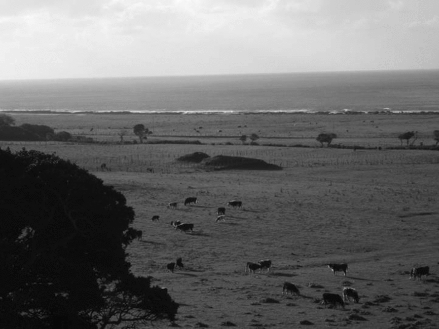
This architectural complex (rehuekuel in Mapuche terminology) is located on the northeastern part of Mocha Island on a Holocene marine terrace (Figure 1d). It is in a flat area at 43 msl and about 650 m from the current shoreline, on a level that is above the highest strandline of the Holocene terrace (Nelson and Manley Reference Nelson and Manley1992). This area is bracketed by an arm of the central range to the north and an ancient landslide to the south, while to the east it is open, facing the ocean and, across that, the mainland. This positioning creates quite an amphitheatric setting for the complex itself (Figure 3 and Supplemental Figures 1 and 2). The area is covered with grass and is used for animal husbandry rather than agriculture, which has helped preserve the entire complex and protect its soil integrity.
Northward view (from above the ancient landslide) of the architectural complex.

The complex consists of a platform or extensive leveled surface (ñichi in Mapuche terminology), which has an elliptical shape and covers ~9.2 ha. Above this there are two side-by-side mounds, or kuel. Although there is no clear-cut distinction between the platform and the mound bases, because they constitute a single anthropogenic continuity, the mounds rise from the present surrounding ground level by about 2.8 m for the North Mound and 3.1 m for the South Mound.
Materials and Methods
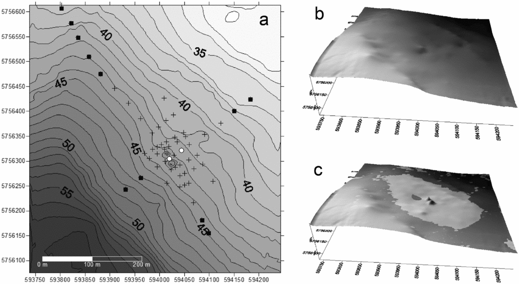
The mounds-and-platform complex was investigated using two complementary strategies. The first was a trench oriented from the top of the North Mound into the space between the two mounds. The goal of the trench was to access the mound's stratigraphy and to reach the original paleosol. The second strategy involved a set of 49 auger cores distributed all over the platform, as well as beyond it (Figure 4a). The goal was to estimate the extension and depth of the platform and its stratigraphy at different points, in order to better understand the construction efforts entailed.
(a) Topographic map of the research area, with elevations relative to sea level; auger cores with a buried paleosol (black crosses), auger cores without a buried paleosol (black squares), auger cores with a buried paleosol and artifacts in it (white circles) are all indicated. (b) Digital elevation model of the paleosurface. (c) Digital elevation model of the current surface, showing the maximum refill area occupied by the platform and the mounds (in light gray).

A topographic survey was undertaken using a differential GPS and a total station over 45 ha, centered at the mounds. Auger core data were used to create topographic maps of the current surface and the paleosurface before mounds-and-platform construction (Figure 4b and 4c). Auger cores that reached a point beyond the platform without paleosol are located on the north-south and east-west axes. The paleosurface grid was created by subtracting the depth of paleosol surface from the current surface altitude (Supplemental Figure 3).
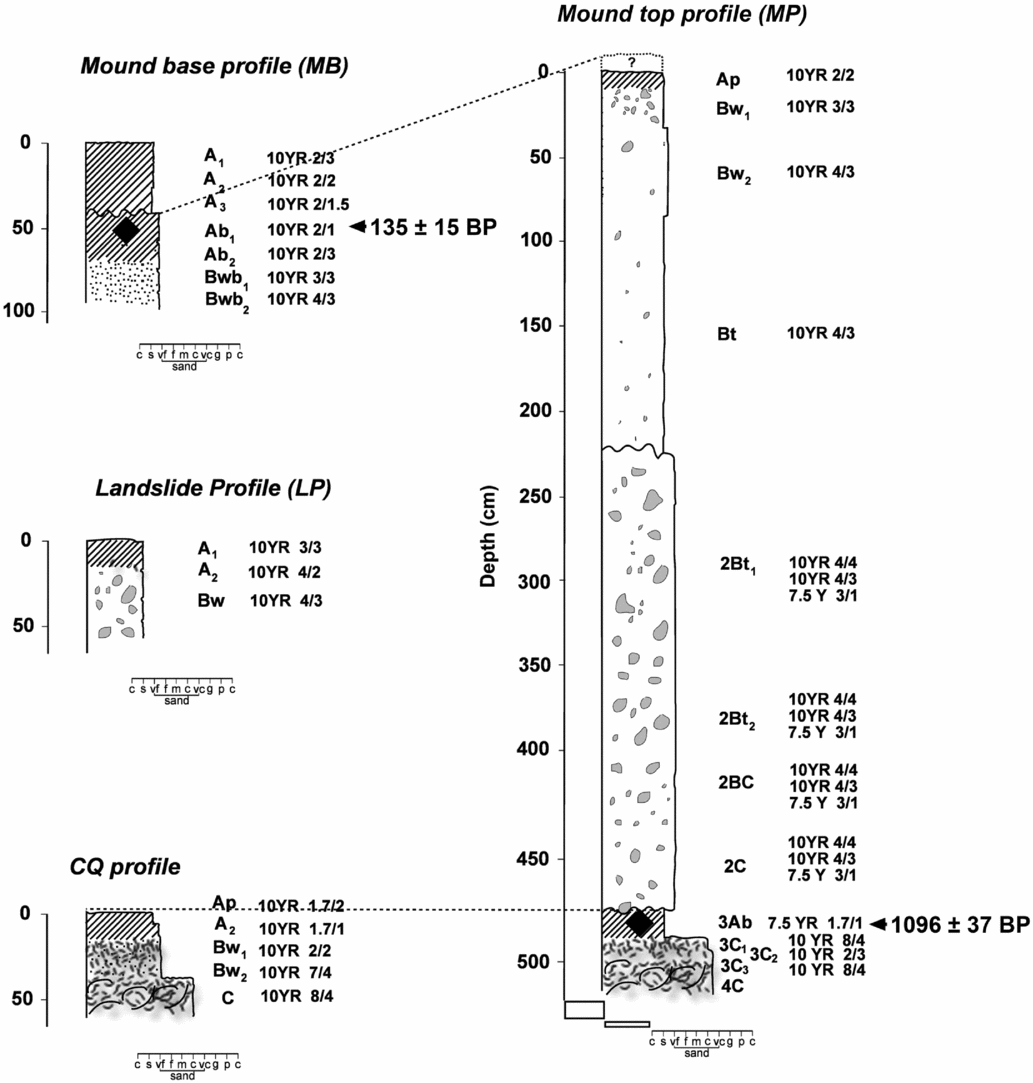
To understand the architectural complex's stages of construction and the potential materials used to build the complex, we performed a general survey of the soils on the eastern part of the island, in addition to studying the trench and two soil profiles located at opposite ends of the mound trench (Figure 5 and Supplemental Figure 4). The profiles in the trench are named mound top profile (MP) and mound base profile (MB). In our soil survey, we observed that there were generally two types of soil that could be differentiated by their parent material: those that formed in Tertiary deposits from the Tubul and Ranquil formations, and those that developed in Quaternary calcareous sand (Figure 2). These two types of soil are very different in color and texture and are therefore very easy to distinguish from each other. We thoroughly described a profile for each of these soil types near the architectural complex, one located at the ancient landslide (LP profile), corresponding to the Tertiary parent material, and one located toward the north at the same level as the complex (CQ profile), that developed over the Quaternary calcareous sand (Supplemental Figure 5). Soils that developed in the Tertiary parent material tend to be loamy textured (LP profile), while soils developed in the Quaternary parent material have sandy loam or loamy sand soil textures (CQ profile). For each soil horizon, color (Munsell Color chart), texture, and friability were analyzed, while additional samples were taken for micromorphological analysis. Our micromorphological descriptions were based on the terminology proposed by Bullock and colleagues (Reference Bullock, Fedoroff, Jongerius, Stoops, Tursina and Babel1985). Soil texture was examined for paleosol under the mound at the MP and for the CQ profile. Bulk density was measured using the clod method.
Stratigraphy of profiles mentioned in the text. Soil diagnostic horizons, Munsell soil color, and AMS radiocarbon dates of buried soils are all indicated.

Charcoal samples for 14C dating were collected from the Ab paleosol at the MP and MB profiles. The dates were calibrated using the software Calib 7.0 (Stuiver et al. Reference Stuiver, Reimer and Reimer2005) and the calibration curve SHCal13 (Hogg et al. Reference Hogg, Hua, Blackwell, Niu, Buck, Guilderson, Heaton, Palmer, Reimer, Reimer, Turney and Zimmerman2013). Samples for carpological analysis were taken from the paleosol material of the MP. Soil material was processed with a machine-assisted flotation system. Recovered cultural archaeological remains were also analyzed.
Results
The Mocha Island architectural complex is structured around two mounds located atop a platform that covers an area of about 400 by 300 m, and that has a thickness of ~2.4 m below where the mounds are located (i.e., excluding the thickness of the mounds themselves). The fill materials in the mounds and platform consist of soil from unconsolidated parent material related to sedimentary deposits of fossiliferous clay with mollusk molds and sandstone, which correspond to the Tubul and Ranquil formations. This material is different from the underlying material (paleosol), which is composed of sands, gravels, and shell fragment deposits of Quaternary age. As a result, it is easy to separate these two materials in the stratigraphic column. Given the record of the island's rapid uplift in the last 6,000 years (Nelson and Manley Reference Nelson and Manley1992), it is possible to estimate that at the moment of the mound's construction, the seashore was less than 200 m away.
Macromorphological Soil Features
For the mound, two profiles were described at each end of the trench (Supplemental Text 1 and 2). One (MP) extended from the top of the mound summit down to a depth of 514 cm, and the other profile (MB) extended from the mound base down to a depth of 97 cm.
The MP consisted of two main sections (Figure 5 and Supplemental Figure 4): from 0 to 474 cm, corresponding to anthropogenic deposited soil material, and from 474 to 524 cm, corresponding to paleosol buried after the construction of the complex. The first section of MP comprises eight horizons with one discontinuity at a depth of 225 cm, which clearly segregates two construction phases. The underlying paleosol comprises five horizons.
The MB has three horizons, covering a buried sequence of five horizons (Figure 5 and Supplemental Figure 4); at a depth of 45 cm, the Ab1 horizon was found to contain charcoal. The last sequence corresponds to soil development over the mound and platform filling material, whereas the upper A horizons correspond to eroded material, mostly from the mound, that was deposited over the original sequence.
The discontinuity inside the MP consists of an abrupt boundary separating two layers that differ in color, the amount of coarse fragments they contain, and their consistencies. Both construction phases used similar materials, removed from Ranquil and Tubul formation deposits, which are at different stages of weathering and consistency (Supplemental Figure 6 and Supplemental Text 3). The clay and sand fragments of sedimentary origin are clearly separated from the weathered soil fill material. These materials suffered pedogenic processes indicated by the presence of color and structure development, as well as clay illuviation features and a dark-colored upper horizon, which reflects the accumulation of organic matter. This pedogenic development of the profile could be clearly seen at a depth of at least 437 cm. The degree of material mixing, features of pedogenic development prior to the material's transfer, and the similarity to the profile described at the nearby landslide (LP [Figures 1c and 5 and Supplemental Figure 2]) all indicate that a material of similar origin to that observed at LP was used to construct the mound.
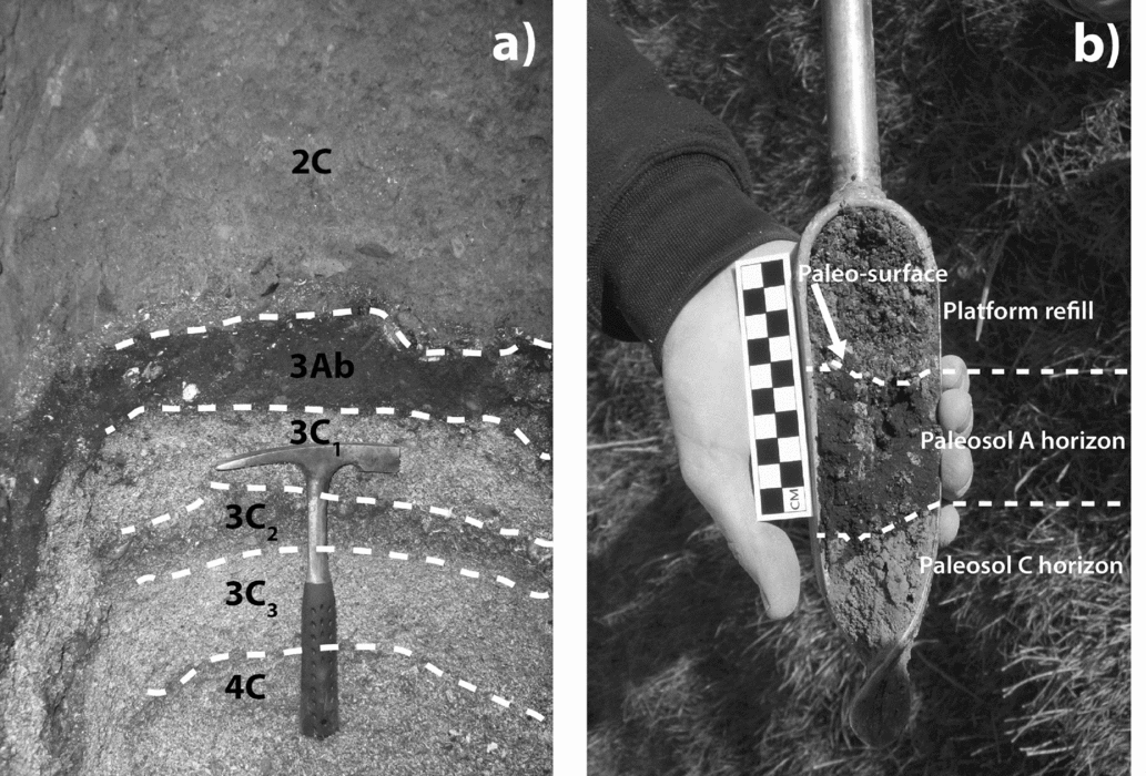
The differences between the upper filling material and the underlying paleosol are clear (Figure 6). There is an abrupt boundary and a clear change in material content, as well as the presence of a dark horizon, reflecting a formerly exposed A horizon that accumulated a significant amount of organic matter, giving it a characteristic dark color. The contact between the two materials appears as a smooth, continuous gray layer with ash and a high amount of charcoal. The parent material of the paleosol corresponds to sand composed of seashell fragments of Holocene age (Nelson and Manley Reference Nelson and Manley1992).
(a) Contact between mound fill (horizon 2C) and paleosol (3Ab), which shows the contrast between the fill material and the beach sands and shells that overlie it. (b) Auger core showing the contact between both materials.

The exposed CQ profile at the same level as the paleosol displays a sequence with well-developed Ap and A2 horizons, with pedogenic development down to at least 37 cm (Supplemental Figures 4 and 5). This profile corresponds to a soil with a similar initial exposure age as the paleosol, but with continuous exposure (Figure 4 and Supplemental Figure 3). The buried paleosol at the MP has an A horizon that is 11 cm thick, revealing that the surface over which the mound was built corresponded to a young and poor soil.
Platform and Mounds Dimensions
Two topographic surfaces were generated. The first surface (Figure 4b) corresponds to the paleosurface that existed before the mounds and platform were constructed. Its stratigraphic ceiling was the contact between the fill of the platform and mounds complex and a buried A horizon (equivalent to horizon 3Ab in Figures 5 and 6). For the auger cores where no paleosol was found, and for those points beyond the auger core survey, the paleosurface was assumed to be equivalent to the present surface. The second surface (Figure 4c) corresponds to the current surface.
The calculated area of the complex is between 5.5 and 12.8 ha, with an average of 9.2 ± 3.7 ha. The difference between these values results from calculating the area of the platform surveyed with the auger cores (5.5 ha) and the value obtained after interpolating all points beyond that survey (12.8 ha; Figure 4). Using these values, an average volume of 42,996 ± 2,900 m3 was obtained for the material used to construct the platform and mounds. For simplicity's sake, we will take the averages as the most suitable values. The bulk density of the platform and mound fill is an average 1.35 mg/m3, which corresponds to 58,045 tons of filling material.
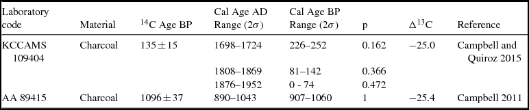
Absolute Dates
The first sample was taken from the buried Ab paleosol horizon in the MP, and it provided a date of 1096 ± 37 BP (AA 89415). The second sample was taken from the Ab horizon in the MB, yielding a date of 135 ± 15 BP (KCCAMS 109404; Table 1). The oldest date provides the maximum time since when the paleosol was buried under the architectural complex's fill. It implies that construction of the complex started around the Early Ceramic to Late Ceramic transition. Nonetheless, the existence of at least two discernible construction events at the North Mound suggests that much of its construction can be attributed to the Late Ceramic El Vergel Complex period.
Absolute Dates from Mocha Island Mounds-and-Platform Complex

Note: Dates were calibrated using the software Calib 7.0 (Stuiver et al. Reference Stuiver, Reimer and Reimer2005) and the calibration curve SHCal13 (Hogg et al. Reference Hogg, Hua, Blackwell, Niu, Buck, Guilderson, Heaton, Palmer, Reimer, Reimer, Turney and Zimmerman2013).
The later date likely corresponds to the 1840s Mocha Island recolonization. This occupation included clearing the forest with fire to open up areas for agriculture (Cañas Pinochet Reference Cañas Pinochet1902). In this case, the sediments that eroded from the mound helped to preserve this thin charcoal layer, and this allows us to assume that a thicker A horizon covered the mound until it eroded during recolonization.
Archaeological Remains
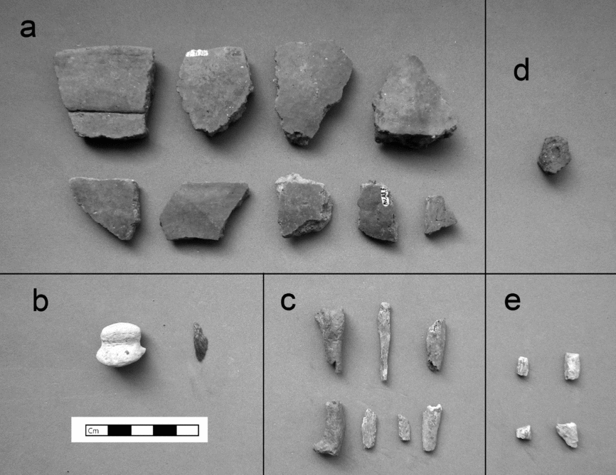
Excavation of the mound trench and the auger cores revealed that the filling material used to build both the mound and the platform was completely devoid of any cultural material. Instead, the only archaeological remains were recovered from the paleosol, and more specifically from the Ab horizon (Figure 7).
Archaeological materials recovered from the paleosol. In the mound trench: (a) ceramics sherds, (b) lithics, (c) bone fragments; in auger core #12, (d) ceramics; in auger core #24, (e) bone fragments.

At the mound trench, the paleosol provided nine undecorated nondiagnostic ceramic sherds, seven bone fragments (two of Spheniscus sp. and five indeterminate), and two lithics (a small sandstone net-sinker and a schist flake). Auger cores #12 and #24, directly adjacent to the North Mound, yielded a single undecorated ceramic sherd and four indeterminate bone fragments, respectively. Finally, a survey of the entire architectural complex area found two ceramic sherds and six lithics; these were neither chronological nor functionally informative.
The sediments from the paleosol material of the MP trench revealed the presence of a sample of botanical taxa (Supplemental Table 2); these remains have to predate the construction of the architectural complex. Both the Chenopodium sp. and Poaceae are part of the Mocha Island archaeobotanical assemblages. The former could be a variety of wild chenopodium or quinoa (Chenopodium quinoa), while the latter probably corresponds to a collected and/or cultivated cheatgrass.
Discussion
The construction of architectural complexes such as the one described here is one of the features of some late prehistoric and historic indigenous communities in southern Chile. Dillehay (Reference Dillehay1986, Reference Dillehay2007, Reference Dillehay and Dillehay2014) has reported extensively on these complexes, mostly through his research on Purén-Lumaco. Our discussion then, will take a comparative approach, contrasting the Purén-Lumaco sites with the Mocha Island complex described above.
Dillehay indicates that some of these architectural complexes or rehuekuel consist of a platform or ñichi, and mound(s) on top of it, called kuel. That is the case on Mocha Island as well. However, what is different and surprising is the size and volume of the Mocha Island complex. Using the Purén-Lumaco data (Dillehay Reference Dillehay2007; Dillehay and Saavedra Reference Dillehay and Saavedra2010, Reference Dillehay, Saavedra and Dillehay2014), we have estimated that the mainland platforms measure from 0.04 ha (Ñachekuel [Dillehay and Saavedra Reference Dillehay and Saavedra2010:201]) up to 3.2 ha (Rehueñichikuel [Dillehay and Saavedra Reference Dillehay and Saavedra2010:226]), although most are no more than 0.2 ha. It should, nevertheless, be noted that the Purén-Lumaco area has been subject to forestry, agricultural activities, and public works (e.g., road construction), which have certainly resulted in the loss of fill material at some of these complexes.
In contrast, the platform at Mocha Island covers ~9.2 ha. This aspect is even more striking when one considers that native population estimates for Mocha Island reach only up to about 1,500, while population estimates for Purén-Lumaco are in the range of 10,000 to 30,000. In terms of per-capita labor, this single construction project may have been much more demanding for the people on Mocha Island than at Purén-Lumaco, if not for the many more rehuekuel that were built at Purén-Lumaco. Therefore, in the long run, the demand on mainland inhabitants might have been much greater than on Mocha Island.
In fact, in the case of Mocha Island, the nature of the filling sediments allows them to be more easily and clearly isolated from the paleosol. The parent material of the paleosol is a Quaternary seashell-rich material, while soils of unconsolidated sediments from the Ranquil and Tubul formations were used for the fill material, giving it a texture, color, and consistency that are distinct from the paleosol.
Another point of comparison is the mounds themselves. On Mocha Island, the filling sediment was completely devoid of cultural material, and the most likely explanation for this is that the sediment came from the nearby landslide formed over the Ranquil and Tubul formations, which is the closest source of material with these characteristics. On the other hand, for Purén-Lumaco, Dillehay (Reference Dillehay2007, ed. Reference Dillehay2014) reports the presence of archaeological features such as different color layers and burning events, and cultural materials such as ceramics and faunal remains. Also absent on Mocha Island are differentiated “artificially prepared soil layers” or reñinmapu like those found at the Purén-Lumaco mounds, added as part of the kueltun rituals. These characteristics imply the following for the latter area: a) the use of sediments that already contained cultural remains from, for example, domestic middens; b) the addition of cultural remains, as well as soil layers, to the filling sediments as, for instance, offerings; or c) both. In fact, Dillehay and Saavedra (Reference Dillehay, Saavedra and Dillehay2014) described mounds formed by hundreds of different pockets of poncho-loads—woven blankets used to carry dirt—which correspond to individual loads of soils of different texture and color. The various soils at Purén-Lumaco have been linked with soil series located in different parts of the valley (Seguel et al. Reference Seguel, Pino and Dillehay2005, Reference Seguel, Pino, Dillehay and Dillehay2014). The diversity of soils used for mound construction was particularly pronounced during the prehispanic period in Purén-Lumaco, while more homogeneous soil materials were used for the Hispanic levels (Dillehay and Saavedra Reference Dillehay, Saavedra and Dillehay2014:217–220). The use of diverse soils was interpreted as representing the relationships among the lineages of the mound builders, with different soils sourced from each lineage's homeland (Dillehay and Saavedra Reference Dillehay, Saavedra and Dillehay2014:218).
In contrast, at Mocha Island the homogeneity of the fill material made it extremely difficult to isolate different construction events. It was possible to identify only one boundary between stages, which does not present a buried A horizon. The absence of buried soil inside the mound fill might reflect a process of rapid construction, perhaps with a short break between the two construction events. Young soils of known age on the island show high soil production rates: Bahlburg and Spiske (Reference Bahlburg and Spiske2012) described 5 to 10 cm thick soils in the shore uplifted after the 1835 earthquake. Because soil production declines exponentially as depth increases (Heimsath et al. Reference Heimsath, Dietrich, Nishiizumi and Finkel1997), we expect high initial rates of soil formation for the beginning decades (as shown by the 5 to 10 cm thick soils after 175 years). The absence of even a very thin soil inside the mound allows us to think in terms of a unique break period that might not have exceeded the duration of a century.
This means that the construction of the mounds was very probably a rapid and continuous process. The absence of any datable or chronologically diagnostic material inside the mound fill prevents us from estimating the precise timing of construction. Nevertheless, the degree of pedogenic development of the soil in the platform and mounds after their construction allows us to interpret a long period of soil formation based on the following facts: thickness and pedogenic development of the MB soil (52 cm), the amount of eroded material that constitutes the three upper A horizons (55 cm), and the average thickness of 24 cm for the A horizon of the platform. Considering soil production values on Mocha Island, a 24 cm thick soil (considering the thickness of the MB's A horizon) should have been exposed for ~560 years at least. This implies that the mounds and platform had already been there for at least five centuries before the beginning of the current occupation (AD 1840s), suggesting that the construction of the architectural complex ended around AD 1300, with a maximum building time of around 300 years. In that time, the mounds would have been visible from the shoreline.
As indicated, construction of the complex began around AD 1000. This was a time of significant change in southern Chile, as reflected in the region's incorporation of new technologies and goods, higher population densities, and almost certainly the emergence of more complex social organization. Therefore, undertaking a construction project of this scale is by no means unexpected. It is important to indicate that, at that moment, the area selected for the platform-and-mound complex must have contained one of the few developed soils of the Holocene plains surrounding Mocha Island, since it was located on one of the few older terraces above the 38 m strandline (Nelson and Manley Reference Nelson and Manley1992).
Given that an effective and permanent colonization of Mocha Island can be dated from AD ~1000 onwards, and since the base levels of the eight communities (expansive domestic areas ranging from 4 to 15 ha that most closely resemble homesteads) identified in the island (Figure 2) date to that moment and/or their middens increase dramatically from that time on (Supplemental Table 1), the commencement of construction on this architectural complex can be interpreted as marking a “foundational event” for the Mocha Island community. This date also coincides with changes in the island's vegetation and a decline in forest species, recorded in the palynological record of a nearby stratigraphic column (Le-Quesne et al. Reference Le-Quesne, Villagrán and Villa1999). This occurred contemporaneously with the presence of charcoal in the record, suggesting forest clearance activities that probably were undertaken to habilitate space for camelid (Camelidae sp.) grazing and agricultural activities. In addition, the AD ~1300 date, taken as a milestone for the conclusion of the complex's construction, marks a moment in which these eight communities were already established, based on the absolute dates obtained for them.
These characteristics are reminiscent of Dillehay's ethnographic work in Purén-Lumaco. He indicates that some mound complexes or rehuekuel served as the plaza where ritual, political, and/or festive activities were performed. On Mocha Island, the very nature of the filling sediment used to build the architectural complex –with its remarkable differentiation from any surrounding materials, in terms of both color and texture–allows us to propose that it was the deliberate intention of the indigenous inhabitants to set apart this area, creating a unique space that was unequivocally distinguishable by its appearance and where a visible physical boundary marked whether one was inside or outside this space. In fact, no less than 600 m separate this architectural complex from the closest domestic sites (P29-1 and P31-1; Figure 1d), and because of its amphitheatre-like location, there is no intervisibility between the complex and these sites. In fact, the soil at site P29-1, which formed in a parent material of calcareous sand similar to the CQ profile, was not used in the construction of the mounds and platform. These characteristics thus lead us to propose that the complex was a truly public space, not owned by any one particular island community.
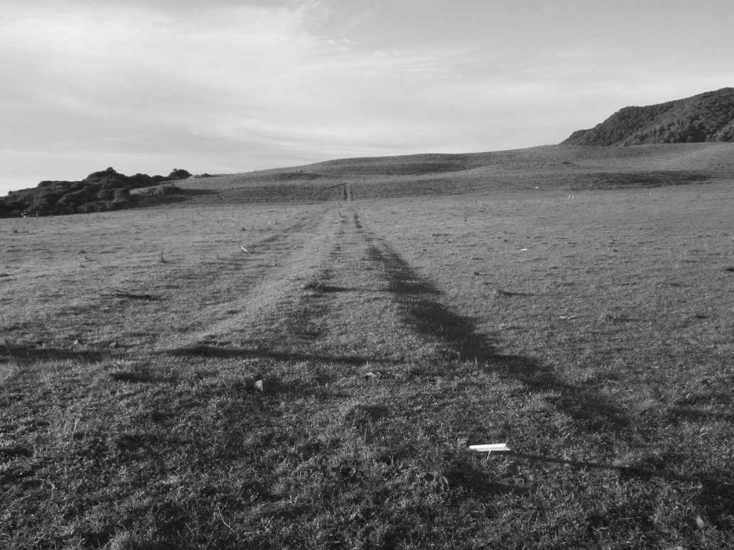
Additionally, from within the platform area it is possible to distinguish at least two strips of earth. These are each about one meter wide and 100 to 200 m long, extending from the mounds to the southern edge (the ancient landslide) of this apparent ceremonial space (Figure 8). Initially, we interpreted these strips as possible causeways (Campbell Reference Campbell2011:206–207), but without ruling out that possibility, we are also inclined to think that these may correspond to boundaries of a field for the palín game. According to López (Reference López2011:147–158), palín fields are demarcated by digging a ditch and lining the removed dirt along the field's edges. The size of palín fields varies significantly, ranging from 50 to 500 m long and 5 to 83 m wide.
Strip of earth going from the mounds to the ancient landslide.

The already advanced implications of the Mocha Island complex are even more remarkable if one considers that it is the only such site on the entire island, a point supported by the full coverage survey that we conducted (excluding the steep central forest). Therefore, this complex would have been the central ideological hub for the island's entire indigenous population. This situation is again a clear contrast with Purén-Lumaco, where more than 300 mounds have been identified. As such, it could indicate that Mocha Island did not reach the degree of social complexity achieved at Purén-Lumaco, and that the island population did not have to sustain a similar level of construction activity over the centuries. Still, the Mocha Island architectural complex may denote the occurrence of a much more hierarchical or consolidated political situation compared to Purén-Lumaco, one that prevented the spread of this building practice to other sectors of the island.
It is worth mentioning that Spanish, Dutch, and English ethnohistorical sources (Campbell Reference Campbell2011:298–354) explicitly indicate the existence of individuals of social prestige and political importance on Mocha Island. In addition, one of these explorers (Van Noort 1600 [Ijzerman Reference IJzerman1926:54–58; Van Meurs Reference Van Meurs1993]) arrived at the island when its inhabitants were holding a festival, strikingly analogous to Dillehay's ethnographic reports on ceremonies that occur in the present day at the Purén-Lumaco rehuekuel. Still, the contrasting views that emerge from Mocha Island and Purén-Lumaco might also represent different social, political, and ideological approaches to the construction, use, and significance of early public architecture.
Turning to a different aspect of mound building, it is worth mentioning the Mapuche myth of the struggle between the water and earth snakes, Cai-Cai and Tren-Tren, respectively, in which humankind is saved by escaping to the top of Tren-Tren and then making a human sacrifice (Foerster Reference Foerster1993). Therefore, in a territory as prone to earthquakes and tsunamis as southern Chile (Ely et al. Reference Ely, Cisternas, Wesson and Dura2014; Garret et al. Reference Garrett, Shennan, Woodroffe, Cisternas, Hocking and Gulliver2015; Huellas Mapuches 2011; Lenz Reference Lenz1912), building a mound can take on the significance of creating a local protective Tren-Tren, where the myth is reenacted through successive constructions, rituals, and offerings. In fact, in Purén-Lumaco the largest and most important kuel is TrenTrenkuel (Dillehay Reference Dillehay2007:106). In the case of Mocha Island, it is possible that the filling material came from the large ancient landslide that demarcates the architectural complex to the south; that landslide could even have been an outcome of one of these catastrophic events.
Finally, having in hand estimates of the material removed and used to build the Mocha Island architectural complex (42,996 m3 and 58,045 tons), of the years elapsed between the start and end of its construction (300 years), and of the island's native population (1,500 people), the next step would be to estimate the labor requirement for a public project such this one. Nevertheless, approximations of this kind are virtually absent in the anthropological literature.
One of the few such attempts was by Erasmus (Reference Erasmus1965), using actual ethnographic experiments. Based on his results, with a distance of 200 m between the source material excavation site and the fill destination, as is the case with the ancient landslide and the Mocha Island mounds, a single worker is able to carry 1.1 tons per day. This translates into a total of 52,767 worker-days for the island's complex, implying that a workforce of 500 people—one-third of the estimated native population for Mocha Island—could have built it in 106 days. If we opt to use another of Erasmus’ estimations, in which he calculated 5.25 worker-days per m3 of fill, building the Mocha Island complex would then require 225,729 worker-days, translating to 451 days of construction, again with a workforce of 500.
Given that the first estimation is much more optimistic, we prefer the second one. In any case, both show that building the complex was a perfectly feasible endeavor for a small population, and that they would have been able to accomplish it in a rather short time span. Thus we consider this estimation of labor requirements to be entirely congruent with the gathered geoarchaeological information, which indicates rapid construction.
Elaborating on estimations by Erasmus (Reference Erasmus1965), among others, Drennan and colleagues (Reference Drennan, Peterson, Fox, Douglas Price and Feinman2010) and Peterson and Drennan (Reference Peterson, Drennan and Smith2011) have proposed a “tax rate” index, understood as the per-capita burden for carrying out public works, or as the number of days’ labor per year per available laborer that is required for construction. This kind of index allows for the development of a comparative perspective beyond the culture-historical peculiarities of each society, helping increase our understanding of the processes of social change worldwide (Smith et al. Reference Smith, Feinman, Drennan, Earle and Morris2012). In this fashion, the “tax rate” for the Mocha Island architectural complex can be estimated at 1.5 days/worker/year. This value turns out to be a close equivalent to the “tax rate” calculated for the construction of an archaeological landmark such as Pueblo Bonito in Chaco Canyon (Drennan et al. Reference Drennan, Peterson, Fox, Douglas Price and Feinman2010:64–70).
Conclusions
The research conducted shows that mounds and platforms and the practices related to their construction and usage are a key aspect to understanding the late prehistoric and historical indigenous societies of southern Chile, the southernmost population in the Americas that engaged in the construction of these public spaces. Beyond this overarching statement there emerges a picture of remarkable local peculiarities. On one hand, not all communities engaged in the construction of public architecture, and those who built such structures did not do so in a homogeneous fashion. While the landscape at Purén-Lumaco is dotted with mounds, on Mocha Island there are just two mounds in a very circumscribed setting; at the former the mound fill contains artifacts, features, and a variety of soil types, and at the latter these are almost absent.
Both situations must be linked to the sociopolitical changes that populations in southern Chile experienced starting in AD ~1000, marked by the emergence and development of much more complex societies, encompassed under the label of El Vergel Complex. In this context, it is worth noting that in spite of Mocha Island's geographical marginality, its low population density in comparison to Purén-Lumaco, and the abrupt and drastic termination of its occupation in AD 1687, its indigenous inhabitants were not disconnected from the contemporary regional processes occurring on the mainland. Therefore, geographical position need not be equated with sociopolitical preeminence or backwater status.
It remains to be seen whether the mechanisms outlined in Purén-Lumaco (population growth, social emulation, competitive feasting, differential power relations between lineages, circumscription) as leading to mound building were the same ones operating across all of southern Chile. In addition, it is fundamental that we further examine the sociopolitical processes occurring in those areas where these architectural complexes did not manifest. In other words, we must assess to what extent these processes and their materials correlate to and can be explained by circumscribed and local factors or by broader and regional factors, or both, and how this can illuminate our understanding of cultural diversity at large. Finally, our research also highlights the importance of integrating different scientific approaches (archaeology and pedology) to produce a richer and more complete knowledge of past social dynamics.
Acknowledgments
To the research project grants NSF-BCS 0956229, FONDECYT 3130515, and FONDECYT 11150397. The research activities were authorized by Consejo de Monumentos Nacionales under ORD. N° 0248 of 2009, as well by the parcelas owners don Roberto Silva and don “Goto” Parra. To those who participated in the Mocha Island field campaigns, especially in February 2010. To Ronald Amundson, Fernanda Falabella, Jacobus Le Roux, and Andrés Troncoso for their comments on an earlier draft of this paper. To our professors, colleagues, and friends at the University of Pittsburgh, UC-Berkeley, Universidad de Chile, and Pontificia Universidad Católica de Chile. To the three anonymous reviews, whose comments contributed to the development of this paper.
Data Availability Statement
The photographs used in the manuscript are the property of the authors. The drawings were designed by the authors. Topographic data were obtained from a field survey and may be requested from the authors.
Supplemental Materials
Supplemental materials are linked to the online version of this article, which is accessible via the SAA member login at https://doi.org/10.1017/laq.2017.42.
Supplemental Figure 1. Southward aerial view of Mocha Island, with the main cultural and natural features mentioned in the text.
Supplemental Figure 2. Westward view of the mounds. Part of the ancient landslide is on the left edge.
Supplemental Figure 3. Transversal major axis section of auger cores from research area NW-SE, showing the paleosurface and auger core depth. Vertical and horizontal axes are not at the same scale.
Supplemental Figure 4. Horizontal section of mound trench. Mound Base profile (MB) at the left, and Mound Top profile (MP) at the right.
Supplemental Figure 5. Profiles showing the parent material for the two main soil types present on Mocha Island: (a) Typic Udipsamment soil developed in a parent material of Calcareous sand; (b) Dystric Haplustept soil developed in a parent material of Tertiary rocks corresponding to the Tubul and Ranquil formations.
Supplemental Figure 6. Micromorphological features of: (a) Mound Top Profile (MP) Bt1 horizon (130 cm), showing the jumbled nature of the soil aggregates in the fill: an unweathered silt aggregate (S) residing next to an iron oxide nodule fragment (Fe) and a silt aggregate with iron oxide quasicoating (upper right); (b) sharp boundary contact between the fill material (horizon 2C) and paleosol (horizon 3Ab).
Supplemental Text 1. Soils Pits Horizon (Stratum) Description (For Nomenclature used see Supplemental Text 2)
Supplemental Text 2. Soil horizon terminology used (From Schoenberger et al. 2002)
Supplemental Text 3. Micromorphological Soil Features
Supplemental Text 4. Mocha Island's population estimate
Supplemental Table 1. Absolute dates from Mocha Island archaeological sites
Supplemental Table 2. Carpological remains recovered from the Mound top Profile (MP) trench
Supplemental Material References.