INTRODUCTION
Protected areas (PAs) have long been the cornerstone of conservation strategies to halt biodiversity losses and ecosystems degradation (Chape et al. Reference Chape, Harrison, Spalding and Lysenko2005; Hansen & DeFries Reference Hansen and DeFries2007). To an extent, this understanding has motivated the international community to adopt binding conservation targets of biodiversity representation in PA networks (CBD 2004; CBD 2010). In turn, these have brought about a significant increase in the number and area of PAs over the last two decades (Woodley et al. Reference Woodley, Bertzky, Crawhall, Dudley, Londoño and MacKinnon2012; CBD 2014). Many representativeness and gap analyses of biodiversity at global and national scales have been conducted (e.g. Brooks et al. Reference Brooks, Bakarr, Boucher, da Fonseca, Hilton-Taylor and Hoekstra2004; Dietz et al. Reference Dietz, Belote, Aplet and Aycrigg2015), yet the coverage of PAs remains biased (Montesino Pouzols et al. Reference Montesino Pouzols, Toivonen, Di Minin, Kukkala, Kullberg and Kuustera2014; Watson et al. Reference Watson, Dudley, Segan and Hockings2014). Assessments of how well PA networks represent biodiversity have not paid attention to political boundaries, and therefore ignored the reality that global and regional PA networks are formed by national networks with their own history (Joppa & Pfaff Reference Joppa and Pfaff2009). There has also been a tendency to disregard prior spatial configurations of PA networks as baselines for understanding their development, despite the evidence on PA downgrading, downsizing and degazettement (PADDD) (Bernard et al. Reference Bernard, Penna and Araújo2014; Mascia et al. Reference Mascia, Pailler, Krithivasan, Roshchanka, Burns and Mlotha2014).
The Caucasus ecoregion extends for c.580 000 km2 across the territories of Armenia, Azerbaijan and Georgia, the southern Russian Federation, northwestern Iran and northeastern Turkey (Mittermeier et al. Reference Mittermeier, Robles Gil, Hoffmann, Pilgrim, Brooks and Mittermeier2004). Under the Soviet regime, most Caucasus PAs were created based on a strict protection paradigm – the so-called ‘Zapovednik’ concept (Kozhevnikov Reference Kozhevnikov1909) – which made the system monotonous and rigid in terms of biodiversity representation and use of natural resources. The disintegration of socialism in 1991 allowed former Soviet countries in the Caucasus to adopt PA management principles from the West (Williams et al. Reference Williams, Zazanashvili, Sanadiradze and Kandaurov2006). For instance, 2.4% of Georgia was covered by Zapovedniks in 1990 (Sokolova & Syroechkovskii Reference Sokolova and Syroechkovskii1990), whereas the PA network of Georgia covered 7.2% of its territory in 2009 and included all six International Union for Conservation of Nature (IUCN) categories (Zazanashvili & Mallon Reference Zazanashvili and Mallon2009).
Throughout the 20th century, the Caucasus faced an increase in human-related threats to biodiversity, especially after the collapse of the Soviet Union due to institutional changes, socio-economic crises and armed conflicts (Krever et al. Reference Krever, Zazanashvili, Jungius, Williams and Petelin2001). In response, the Ecological Conservation Plan for the Caucasus was developed (Williams et al. Reference Williams, Zazanashvili, Sanadiradze and Kandaurov2006). The implementation of this non-binding strategic document, which relates mainly to the former Soviet countries of Armenia, Azerbaijan and Georgia, brought about a significant increase in the number and area of PAs (Zazanashvili & Mallon Reference Zazanashvili and Mallon2009). Yet efforts to apply a systematic conservation planning approach in order to guide the development of national PA networks are of recent origin and are confined to Iran (Makhdoum Reference Makhdoum2008), Russia (Krever et al. Reference Krever, Stishov and Onufrenya2009) and Turkey (Eken et al. Reference Eken, Bozdoğan, İsfendiyaroğlu, Kılıç and Lise2006). The only regional study of the Caucasus that included the PAs of Armenia, Azerbaijan, Georgia and the Russian part of the Caucasus assessed only how well the regional PA network in 2005 represented biodiversity (Zazanashvili Reference Zazanashvili, Bohn, Hettwer and Gollub2005).
In sum, PAs, especially in the South Caucasus (SC; i.e. Armenia, Azerbaijan and Georgia), have increased in number and area, and also diversified to include different management regimes since the Soviet era. This drastic change has raised questions as to how effective the PA network of the SC and its constituent national networks are at representing biodiversity when compared to their PA configurations before the collapse of the Soviet Union in 1991. The SC provides an opportunity to investigate biodiversity representation in PAs beyond state borders and to explore the evolution of PAs in a part of the world where drastic institutional and political changes have taken place. We sought to answer the following questions: (1) How has the PA network in Armenia, Azerbaijan and Georgia changed since 1991? (2) How has the representation of biodiversity in regional and national PA networks of the SC changed between 1991 and 2014? (3) How have changes in the national PA networks of the SC between 1991 and 2014 affected the representation of biodiversity?
METHODS
Study area
The SC extends over Armenia, Azerbaijan and Georgia between latitudes 43°35’11’’N and 38°23’31”N and longitudes 50°22’15’’E and 40°00’23”E, and consists of an area of c.186043 km2 (c.31.7% of the Caucasus ecoregion). The northern and western parts are mostly covered by high mountain grasslands and temperate broad-leaved and coniferous forests, which include the south slope of the Greater Caucasus, the entire range of the northern and eastern extent of the Lesser Caucasus and the Likhi ridge that bridges the Greater Caucasus and the Lesser Caucasus. Meanwhile, along with temperate broad-leaved forests at higher altitudes, dry open woodlands and shrublands, steppes and semideserts dominate the eastern and southern parts of the SC. In addition, the central part of the Colchic refugium (Georgia) and the northwestern part of the Hyrcanian refugium (Azerbaijan) lie in the SC; both are unique features of the Caucasus due to their Tertiary origin, evolutionary history and diversity of relict and endemic vascular plants and tree species (Nakhutsrishvili et al. Reference Nakhutsrishvili, Zazanashvili, Batsatsashvili and Montalvo Mancheno2015). As former Soviet republics, the PA networks of Armenia, Azerbaijan and Georgia were mainly based on strict protection, although some forest- and hunting-managed reserves also existed, and a couple of Soviet-style national parks, whose goal was forest management rather than the protection of ecosystems, were established before the collapse of the Soviet Union (Zazanashvili & Mallon Reference Zazanashvili and Mallon2009).
Changes in PAs
We collected from Sokolova and Syroechkovskii (Reference Sokolova and Syroechkovskii1990), IUCN (1992) and World Wide Fund for Nature (WWF 2009) the following data on PAs: year of gazettement; name in 1991; name in 2014; area in 1991; area in 2014; location/country; Soviet category; and IUCN category. We omitted from our analysis natural monuments since they are sites of aesthetic rather than biodiversity value. Like Bernard et al. (Reference Bernard, Penna and Araújo2014), we grouped PAs into strict protection or multiple-use types. Informed by the conceptual PADDD framework (Mascia & Pailler Reference Mascia and Pailler2011), we then reviewed the information in our database together with historical accounts available in Ministry of Nature Protection of Armenia (1999), Ministry of Ecology and Natural Resources of Azerbaijan (2000) and Agency of Protected Areas of Georgia (APA 2014a) to identify changes in the status of PAs gazetted up to 1991 (i.e. Soviet-era PAs) and the number and area of PAs gazetted after 1991 (i.e. post-Soviet PAs). Additionally, we used geographic information systems (GIS) to identify complexes of PAs along state borders in 1991 and 2014 in order to explore changes in the spatial continuity of vegetation formations.
Representativeness and gap analyses
We prepared in ArcGIS 10.2 (ESRI 2011) two datasets for PAs and one for terrestrial ecosystems. For present PAs (2014), we used the most up-to-date digitized maps of each PA available in the GIS database of the WWF-Caucasus Programme Office (WWF-Caucasus). Second, we compared the legal area of each PA to its GIS shapefile area in order to identify mismatches based on the following criteria: for small PAs (legal area ≤10 km2), a difference between legal and GIS areas of more than 10% of a PA's legal area; and for the other PAs, a difference between legal and GIS areas of more than 10 km2. Third, we used geographic features based on topographic maps of 1:200 000 for Armenia, Azerbaijan and Georgia and our knowledge in order to correct mismatched shapefiles. For Soviet-era PAs, we looked up the oldest shapefiles stored in the GIS archive of WWF-Caucasus for PAs with different legal areas in 1991 from those in 2014. Using the same approach, the same three documents used to characterize changes in PAs during the post-socialism era and the descriptions of protected habitats and/or historical accounts of Soviet-era PAs (Sokolava & Syroechkovskii Reference Sokolova and Syroechkovskii1990), we created a dataset for PAs existing in 1991. These two time-framed datasets (i.e. Soviet and present) for the national PA networks of each country were then combined to create datasets at the SC level.
For the ecosystem-level dataset, we extracted from the interactive application of the Map of Natural Vegetation of Europe at 1:2 500 000 scale (Bohn et al. Reference Bohn, Gollub, Hettwer, Neuhäuslová, Raus, Schlüter and Weber2004) GIS-based data on vegetation formation for the SC. Next, we identified remaining areas of each vegetation formation by removing from the SC ecosystem-level layer anthropogenic land uses and inland water bodies as identified in the Land Use/Land Cover Map of the Caucasus Ecoregion at 1:500 000 scale (Williams et al. Reference Williams, Zazanashvili, Sanadiradze and Kandaurov2006). Third, we split the ecosystem-level dataset for the SC on the basis of state borders in order to create each country's ecosystem-level dataset, then overlaid the ecosystem-level dataset for the SC with its Soviet and present network of PAs and the ecosystem dataset for each country with their Soviet and present PA systems. We used a uniform target of at least 17% representation for each vegetation formation in order to measure representativeness and assessed gaps in the PA network in the SC and the three national PA networks in 1991 and 2014. Finally, we calculated the percentages of how much vegetation formations are covered by PAs in both time frames and compared these to 17% (codes of vegetation formations are the same as in Bohn et al. [Reference Bohn, Gollub, Hettwer, Neuhäuslová, Raus, Schlüter and Weber2004], and they appear between parentheses in the text).
Limitations of the study
Using surrogates for biodiversity (Rodrigues & Brooks Reference Rodrigues and Brooks2007; Fraser et al. Reference Fraser, Beresford, Peters, Redhead, Welch, Mayhew and Dytham2009) and setting minimum targets for its conservation (Chape et al. Reference Chape, Harrison, Spalding and Lysenko2005; Carwardine et al. Reference Carwardine, Klein, Wilson, Pressey and Possingham2009) could be seen as caveats due to their contested nature. We used vegetation formations as surrogates for terrestrial ecosystems because plant community types are largely similar to habitat types in the SC (Akhalkatsi & Tarkhnashvili Reference Akhalkatsi and Tarkhnashvili2012), and habitat protection is one of the most effective approaches for conserving biodiversity (Hughes et al. Reference Hughes, Daily and Ehrlich2000). We used a uniform target of 17% because this value is commonly used to assess the progress of countries towards achieving Aichi target 11 (CBD 2014; Watson et al. Reference Watson, Dudley, Segan and Hockings2014), and also because its achievement, although challenging, could greatly increase the protection of biodiversity (Woodley et al. Reference Woodley, Bertzky, Crawhall, Dudley, Londoño and MacKinnon2012; Montesino Pouzols et al. Reference Montesino Pouzols, Toivonen, Di Minin, Kukkala, Kullberg and Kuustera2014). Another caveat relates to the use of maps with different scales. By choosing vegetation formations, which are the highest hierarchical levels of the Map of Natural Vegetation of Europe (Bohn et al. Reference Bohn, Gollub, Hettwer, Neuhäuslová, Raus, Schlüter and Weber2004), instead of lower-level units, as was done in Zazanashvili (Reference Zazanashvili, Bohn, Hettwer and Gollub2005), we avoided generating considerable mistakes in our calculations due to discrepancies between scales. In other words, the use of maps of different scales is unlikely to qualitatively alter our findings (Venter et al. Reference Venter, Fuller, Segan, Carwardine, Brooks and Butchart2014). Using a static ecosystem layer derived from secondary data (i.e. potential vegetation and land-use maps) allowed us to map biodiversity at the ecosystem level. This could not have been done using spectral analysis of open source satellite imagery (e.g. Landsat) because our ecosystem-level dataset is based on the ecological concept of potential natural vegetation, which refers to the vegetation that would be expected given environmental constraints (e.g. climate, geomorphology and geology), without human intervention or hazard events (Moravec Reference Moravec1998). Yet this came at the cost of not acknowledging other land-use dynamics (e.g. forest regeneration) beyond cover losses between 1991 and 2014.
RESULTS
Changes in the national PA networks of the SC
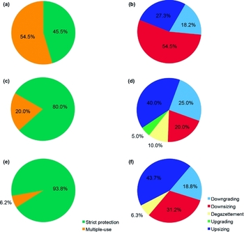
In the SC, we identified a total of 47 PADDD events that have changed legal restrictions and/or boundaries since the Soviet era (76.6% in strict protection PAs). Armenia, Azerbaijan and Georgia, respectively, had 23.4%, 42.6% and 34% of the total PADDD events. Events occurred in 35.7%, 50% and 60.9% of Soviet-era PAs in Armenia, Azerbaijan and Georgia, respectively. Nearly 50% or more of the PADDD events happened in strict protection PAs in Armenia, Azerbaijan and Georgia (Fig. 1). The most common events were downsizing, with six events in Armenia, and upsizing, with eight and seven events in Azerbaijan and Georgia, respectively (Fig. 1). Meanwhile, degazettement was the least common event, affecting three strict protection PAs (two in Azerbaijan and one in Georgia).
Percentage of Soviet-era PAs of the SC affected by PADDD events during the post-socialism era (1991–2014) by type of PA (left-hand pie charts) and type of event (right-hand pie charts). (a and b) Armenia, (c and d) Azerbaijan and (e and f) Georgia.

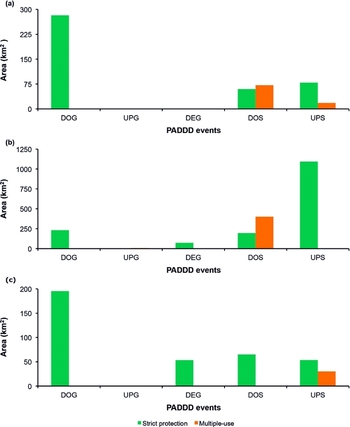
A total of 2913 km2 of Soviet-era PAs in the SC (31.1%) were affected by one or two PADDD events between 1991 and 2014. Armenia, Azerbaijan and Georgia, respectively, had 17.5%, 68.8% and 13.7% of the area of Soviet-era PAs affected by PADDD events. Events that changed legal restrictions of Soviet-era PAs (i.e. downgrading and upgrading) affected 719km2, of which 98.9% was downgrading (Fig. 2). Changes in boundaries of Soviet-era PAs (i.e. degazettement, downsizing and upsizing) affected 2194 km2 during the post-socialism era. Upsizing events changed the largest PA area (1274 km2), whereas degazettement events changed the smallest PA area (126km2). Interestingly, 44 km2 of downgraded PAs were no longer officially considered a PA in Azerbaijan as of 2014 because of its status as a historical site, and c.82% of the extent of degazetted PAs was later used to enlarge a post-Soviet PA in Azerbaijan and a Soviet-era PA in Georgia. We did not include the upsizing in Azerbaijan because it affected a PA established after 1991. The area affected by degazettement, downsizing and upsizing among these three countries varied greatly (Fig. 2), with Armenia, Azerbaijan and Georgia, respectively, having 10.4%, 80.4% and 9.2% of the area affected by these PADDD events. Upsizing affected the largest area in Azerbaijan, and compared to Armenia or Georgia, Azerbaijan was the only country with a net gain of 423 km2 after PADDD events that legally changed the extents of Soviet-era PAs (Armenia and Georgia had net losses of 34 km2 and 35 km2, respectively).
Area of Soviet-era PAs affected by PADDD events that changed their legal restrictions (DOG: downgrading; UPG: upgrading) and coverage (DEG: degazettement; DOS: downsizing; UPS: upsizing) during the post-socialism era (1991–2014). (a) Armenia, (b) Azerbaijan and (c) Georgia. Note: upsizing includes the area added to one, four and two downgraded strict protection PAs in Armenia (58 km2), Azerbaijan (632 km2) and Georgia (11km2), respectively.

After 1991, 47 PAs were created in the SC. Strict protection PAs were only gazetted in Azerbaijan and Georgia (three and one, respectively), which meant that 91.5% of post-Soviet PAs were multiple-use PAs (seven, 12 and 24 in Armenia, Azerbaijan and Georgia, respectively) in 2014. Armenia, Azerbaijan and Georgia, respectively, had 10%, 44.1% and 45.9% of the total area of post-Soviet PAs in the SC (9451 km2). In all three countries, all or almost all the area of post-Soviet PAs fell in the group of multiple-use PAs (100%, 97.2% and 99.9% in Armenia, Azerbaijan and Georgia, respectively). Both changes in Soviet-era PAs and gazettement of PAs after 1991 in Armenia, Azerbaijan and Georgia meant that in the SC there were 126 PAs covering 19 196 km2 in 2014 (i.e. 51.8% more PAs and 105% greater area under protection than in 1991). This means that there was an increase in the coverage of PAs in the SC from 5% to 10.3% during the post-socialism era. Yet the amount of territory covered by PAs varied greatly among the countries of the SC, going from 10.2%, 5% and 2.9% in 1991 to 13.3%, 10.3% and 9% in 2014 for Armenia, Azerbaijan and Georgia, respectively (for a graphic summary of the distribution of PA sizes, see Fig. S1; available online).
Between 1991 and 2014, the number of PAs along state borders increased from six to 21 (i.e. a sixth of the total number of PAs in the SC in 2014), including PAs along the state borders of Armenia and Azerbaijan, Armenia and Georgia, and Azerbaijan and Georgia. As a result, eight out of 12 vegetation formations found in at least two SC countries, which excluding Colchic lowland vegetation formations (S and T) and Caucasian meadow steppes throughout the SC (L) from this analysis, now have some level of connectivity across state borders (Table S1).
Representativeness and gap analyses of vegetation formations and the effect of PADDD events on representation
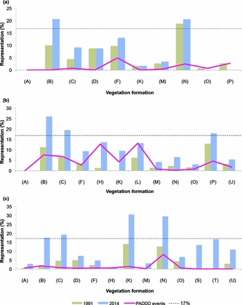
Increases in the number and area of PAs during the post-socialism era brought about changes in the representation of all vegetation formations (see names in Fig. 3). Based on a uniform target of at least 17% for each vegetation formation, not a single vegetation formation reached this target in 1991. After 23 years, only alpine grasslands, thickets and mats (B) were above this target, and Colchic lowland mires (S) and Colchic lowland Alder forest (T) shifted from unrepresented (0%) to under-represented (>0%, <17%) between 1991 and 2014 (Fig. S2, Table S2). The remaining 12 vegetation formations were still under-represented in the PA network of the SC as of 2014, ranging from 2.6% to 16.8% for sub-nival vegetation (A) and sand-dune vegetation complexes and north Caspian and east Transcaucasian halophytic vegetation (P), respectively. Interestingly, these two vegetation formations were also the least and best represented in 1991 percentage-wise, respectively (Table S2).
Representation of vegetation formations in each country of the SC in 1991 and 2014 and the effects of changes in boundaries and legal restrictions of Soviet-era PAs on the representation of each vegetation formation (PADDD events). (a) Armenia, (b) Azerbaijan and (c) Georgia. Vegetation formation names are as in Bohn et al. (Reference Bohn, Gollub, Hettwer, Neuhäuslová, Raus, Schlüter and Weber2004): (A) sub-nival vegetation of high mountains, (B) alpine vegetation, (C) subalpine vegetation, (D) mesophytic and hygromesophytic coniferous and mixed forests, (F) mesophytic deciduous broad-leaved and mixed forests, (H) hygro-thermophilous mixed deciduous broad-leaved forests, (K) xerophytic coniferous forests, woodlands and scrubs, (L) forest steppes and dry grasslands, (M) steppes, (N) oreoxerophytic vegetation, (O) deserts, (P) coastal vegetation and inland halophytic vegetation, (S) mires, (T) swamp and fen forests and (U) vegetation of flood-plains.

Representation of terrestrial ecosystems in the national PA networks of the SC increased in nearly all vegetation formations (Fig. 3). In Armenia, mountain thorn-cushion communities (N) were already represented (≥17%) in 1991. Alpine vegetation (B) moved from under-represented to represented. Meanwhile, deserts (O) and coastal vegetation and inland halophytic vegetation (P) saw their areas under legal protection reduced, which led to the former joining sub-nival vegetation (A) as unrepresented in the PA network of Armenia in 2014 (Fig. 3). In Azerbaijan, coastal vegetation and inland halophytic vegetation (P), together with two vegetation formations associated with high mountain ecosystems (B and C), shifted from under-represented to represented, whereas sub-nival vegetation (A) remained unrepresented in 2014 (Fig. 3). In Georgia, alpine and subalpine vegetation (B and C, respectively), open juniper woodlands (K) and mountain thorn-cushion communities (N) were represented in 2014, and Colchic lowland vegetation formations (S and T), which are only present in Georgia, moved from unrepresented to under-represented in 2014 (Fig. 3).
The effects of changes in boundaries (i.e. upsizing, downsizing and degazettement) and in legal restrictions (i.e. downgrading and upgrading) of Soviet-era PAs on the representation of each vegetation formation varied greatly among Armenia (i.e. from 0.01% to 4.92% for vegetation formations B and F, respectively), Azerbaijan (i.e. from 0.19% to 13.16% for vegetation formations N and L, respectively) and Georgia (i.e. from 0.05% to 8.13% for vegetation formations U and N, respectively) (Fig. 3). In Armenia, changes in boundaries of Soviet-era PAs brought about a negative outcome for the representation of deserts (O) and coastal vegetation and inland halophytic vegetation (P) due exclusively to downsizing, whereas the contribution of upsizing of Soviet-era PAs to increasing representation was limited to only two out of three vegetation formations (C and F) affected by this type of event because of a net gain (i.e. upsizing was larger than downsizing). For four out of seven vegetation formations in Azerbaijan (B, N, O and P) and for two out of six in Georgia (D and O) where downsizing and degazettement took place, these types of events could also have brought about a negative outcome because of a net loss. Yet its impact was largely offset by the area that was set aside after 1991.
DISCUSSION
Our results align with general findings that PADDD events often target the same PA more than once through both changes in boundaries and legal restrictions, as well as significantly reduced extents of PAs that go unseen in national, regional and global coverage estimates due to the increase in the number and area of PAs (Mascia & Pailler Reference Mascia and Pailler2011). In the SC, events of PA downsizing and/or degazettement did not contribute to Armenia, Azerbaijan and Georgia not yet achieving Aichi target 11, as Macias et al. (Reference Mascia, Pailler, Krithivasan, Roshchanka, Burns and Mlotha2014) also found. Yet downsizing did negatively affect the representation of deserts (O) and coastal vegetation and inland halophytic vegetation (P) in Armenia. Our assessment of how PADDD affected biodiversity representation could inform other studies that might seek to research the implications of PADDD for biodiversity and society (Mascia & Pailler Reference Mascia and Pailler2011). Our time frame suggests that the described PADDD events could have led to Armenia, Azerbaijan and Georgia adopting open-market policies and practices after the collapse of the Soviet Union. Yet the possibility that these PADDD events responded to a paradigm shift from strict protection to less restrictive, more multifunctional PAs, as in Brazil (Bernard et al. Reference Bernard, Penna and Araújo2014), should not be underestimated, as our results show that the strict protection PAs of the Soviet period were most affected by PADDD events and that many multiple-use PAs were gazetted after 1991.
The development of PAs during the post-socialism era was an uncoordinated, ad hoc process in Armenia, Azerbaijan and Georgia. First, the extent of vegetation formations covered by PAs varied greatly between each country. Secondly, the expansion of PAs mostly benefited the representation of vegetation formations that had relatively high percentages already covered by PAs in 1991 (Fig. 3), with the exception of Colchic lowland vegetation formations (S and T). This made the national PA networks inherently biased, especially towards vegetation formations (A, B, C and N) associated with high mountain ecosystems (Fig. 3). This finding aligns with the global trend of high mountain ecosystems having high levels of representation as reported in recent PA analyses (Brooks et al. Reference Brooks, Bakarr, Boucher, da Fonseca, Hilton-Taylor and Hoekstra2004; Montesino Pouzols et al. Reference Montesino Pouzols, Toivonen, Di Minin, Kukkala, Kullberg and Kuustera2014). In other words, national PA networks in the SC are still biased towards territories located far from major roads and cities, as well as at high elevation, with steep slopes and low agriculture suitability (Joppa & Pfaff Reference Joppa and Pfaff2009).
Based on the six clauses for a more holistic interpretation of Aichi target 11 (Woodley et al. Reference Woodley, Bertzky, Crawhall, Dudley, Londoño and MacKinnon2012), it seems unlikely that Armenia, Azerbaijan or Georgia could reach at least 17% (clause 1) of ecologically represented areas (clause 2) within their PA networks by 2020. This is not only based on our findings, but also because of an increasing dependence of governments in the SC on natural resources in order to achieve development goals (Zazanashvili & Mallon Reference Zazanashvili and Mallon2009). Due to the increase in the number of complexes of PAs created along state borders between 1991 and 2014, it could be argued that having PAs that are well connected and integrated into the wider landscape (clause 4) has improved at a regional scale. However, clause 4 at a national level is starting to be considered through the implementation of a landscape corridor approach in three pilot sites, one in each country (WWF 2015). Although we cannot assess the other three clauses using our findings, we can say that important areas for biodiversity (clause 3) are covered by PAs (CEPF 2003) and that the management of PAs is more efficient and equitable (clause 5). These two clauses are indirectly supported by the stabilization of key species populations (APA 2014b; Askerov et al. Reference Askerov, Talibov, Manvelyan, Zazanashvili, Malkhasyan, Fatullayev and Heidelberg2015) and the involvement of local people in the management of two PAs in the SC over the last 3 years, respectively. Nevertheless, the SC totally lacks other effective area-based conservation measures (clause 6) because in situ conservation is exclusively achieved through PAs managed by central governmental agencies.
We believe that our results are a first step towards systematically starting to develop the PA network of the SC. They could help conservationists change the status quo, and also serve as a basis for the application of innovative approaches in conservation planning in the SC that takes into consideration dynamic processes at larger landscape and regional scales. This could include climate change (Carroll et al. Reference Carroll, Dunk and Moilanen2010), land-use scenarios (Montesino Pouzols et al. Reference Montesino Pouzols, Toivonen, Di Minin, Kukkala, Kullberg and Kuustera2014) and ecosystem services (Rogers et al. Reference Rogers, Glew, Honzák and Hudson2010) in the selection of sites for further expanding the network of PAs. We argue that the expansion of the PA network in the SC has to be addressed from a new perspective on conservation planning, in which PAs are considered to be elements that are embedded in wider coupled human–natural systems, rather than isolated islands for pure conservation. For this more holistic approach to be successful, maintaining and restoring connectivity between PAs (Seiferling et al. Reference Seiferling, Proulx, Peres-Neto, Fahrig and Messier2011) and planning for biodiversity conservation beyond PAs (Hansen & DeFries Reference Hansen and DeFries2007; Chazdon et al. Reference Chazdon, Harvey, Komar, Griffith, Ferguson and Martínez-Ramos2009), which includes recognizing the value that human-dominated landscapes can have for connectivity (DeClerck et al. Reference DeClerck, Chazdon, Holl, Milder, Finegan and Martinez-Salinas2010), need to be considered. This is not just to protect biodiversity, but most importantly is a way to find synergies and co-benefits between nature conservation and the well-being of local people (DeFries et al. Reference DeFries, Hansen, Turner, Reid and Liu2007; Fischer et al. Reference Fischer, Hartel and Kuemmerle2012).
ACKNOWLEDGEMENT
The authors thank experts from Armenia, Azerbaijan and Georgia for their help in checking our lists of protected areas. Arman Kandaryan and Natia Arobelidze helped us process GIS shapefiles for Soviet-era protected areas in Armenia and Azerbaijan, respectively. The authors are also grateful to our three anonymous reviewers.
Supplementary material
To view supplementary material for this article, please visit https://doi.org/10.1017/S0376892916000424