Introduction
The site of Merquly (ميرقولي ; Merquli or Merculi; UTM 521432, 3955598 38N) is located on Permagroun Mountain, the mountain that has been associated with the Flood as described in the Epic of Gilgamesh (George Reference George2003). Merquly is about 40 km north-west of Slemani (or Sulaimaniyah), Iraq, located near a pass to a small valley that is found within the mountain; the site, at an elevation of 1618 m above sea level, likely guarded this pass as one would go through the Permagroun, suggesting the strategic nature of the pass as well as the site. Indeed, excavation of the site proved difficult due to its isolated location, inaccessible by road, and high elevation. In June 2009, excavations commenced with the goal of uncovering architecture associated with the site. The work was prompted by the discovery of a nearby rock relief, about 200 m to the south-west and about 20 m lower in elevation, possibly representing a local ruler or noble, that may date to the late Parthian period (Zamu and Amedi Reference Zamu and Amedi2011).
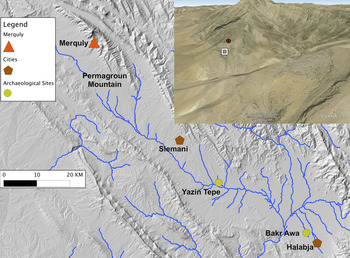
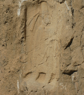
This report summarizes efforts from the 2009 season undertaken at Merquly. Figure 1 indicates the location of the site in relation to Slemani, Iraq and the surrounding region, along with the position of the site and the nearby rock relief. Figure 2 shows the nearby rock relief that has been published previously (Altaweel Reference Altaweel, Marsh, Muhl, Nieuwenhuyse, Radner, Rasheed and Saber2012: fig. 5). In general, the site consists of large stone foundations, where there are possibly several structures that are interrelated, and a likely wall surrounding the settlement or fortification. A number of the stones associated with these features are visible on the surface. While there is some evidence of fire, the site was likely abandoned, as no extensive burning was found. In fact, relatively few artefacts were found on the site, with most contents of the site having likely been removed in antiquity or even eroded.
Map showing Merquly and nearby cities and known archaeological sites. The inset shows a satellite image overlaying elevation data that shows Merquly (red dot) and the nearby rock relief (white square) near the mountain pass. Imagery in the inset is provided by Google Earth (2014) using Cnes/Spot data

The nearby rock relief at Merquly

The Citadel
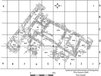
Excavation squares measuring 5 × 5 m were laid out along an area that is called the “citadel” by the excavators, which is a high point along the Permagroun that overlooks the pass and where structures from the site were found. Once excavations began in these squares along the citadel (Fig. 3), a fortress-like structure became evident. The architecture and walls were built on different levels, following the general contour of the ridge the structures were built on, as indicated in Figure 4, which shows different vantage points in squares A–F. One clear building level (Level 1) is evident for the site, with at least two building phases present in some places; these early and late phases are discussed in the text below where they are relatively clear. In addition, there are later intrusions on the structure, including at least one pit (P1) and other areas disturbed by later activity (R4, R17a and CY9), which are recorded as part of Level 0. It is possible that the disturbances in R4, R17a and CY9 are more recent disturbances, while P1 is an ancient intrusion. The main benchmark used for Merquly is indicated as a large “O” in Figure 3.
Plan of excavations that revealed structures in the citadel. The key for the plan is as follows: CY = courtyard, D = door, D? = possible door, L = lane/alley/corridor, H = hearth, R = room, W = wall, and P = pit. In cases where there is a north-south wall, N is used

Elevation variation and walls of the structures in the citadel

Main Excavations
Large stone foundations and smaller stones are evident on the surface and along the main outer south-east–north-west wall (squares A6–D9), which measures 23 m in length, while the north-east–south-west wall extends nearly 30 m (squares B6–D1) in length. Another part of the fortress, extending in the north to D1, and likely having extended further in a north-west–south-east direction, is also evident. Further outer walls are likely also present to the north, but these are not well preserved or not easily visible based on surface investigations. To the south, similarly, evidence of a second wall is apparent based on large tumbled stones, perhaps signifying a second outer wall facing in this direction. The area also includes a large circular installation (P1), measuring approximately 1.5 m in diameter and 2.0–2.2 m in depth. The eastern walls of the installation are damaged, but evidence of paved walls are found in the installation. P1 is found intruding into feature D3, an entrance between L1 and R5, with part of Wall (W)2a partially collapsed due to the pit. Excavations were, in fact, begun near to P1 to clarify the walls and installations around this feature, with W2 and W2a initially excavated and distinguished. From the visible evidence, it seems clear that P1 is a later intrusion into the main citadel structure; this feature is designated as belonging to Level 0.
With the beginning of excavations, a room quickly became apparent. This space (R3) measures 4 × 7 m, with the floor descending in an eastward direction between 40 and 80 cm. This structure is earlier than P1 and is designated as part of Level 1. Various limestone pieces were found, but none clearly showed evidence of being used in any installation. In the middle of the room, another wall was exposed (W2a), measuring 90 cm in width. This wall runs from south-west to north-east. The wall reaches an area where more limestone rocks were found. Overall, the main north wall (W1) contains between one and two courses of stone, with a width of between 0.8 and 1.2 m. The west wall (W3) measures about 1.0 m in width, with worked stones measuring 40 × 35 × 64 cm.
Two nearby areas were next excavated, Courtyard (CY)9 and Room (R)17a, both of which were found to have been disturbed by modern Iraqi army activity. The army had likely used this area during the Iran-Iraq War and its conflict with the Peshmerga, with evidence of modern food and camping items found during excavations. Although heavily disturbed, the direction of the walls in R17a (i.e., W12 and W13) suggest the area was a later construction. Overall, we conclude there were two ancient phases, related to Level 1, for R17a, which was then subsequently disturbed by the Iraqi army (i.e., in Level 0).
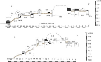
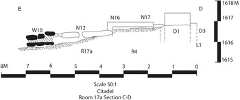
To the west, W14 has an entrance (D2), with another room (R13) becoming apparent after excavations continued in the area. A group of fallen stones (N10), to the east of R17a, appear to be part of R17a. In the south part of W13, evidence of fire was found, with ash evident in the remains. Long stones in the south-western part of R13 suggest that these stones may have been used as part of the drainage, perhaps removing water from a nearby bathroom or helping to drain rainwater from the area. Figure 5 shows a section between R17a and R4, helping to indicate the elevation differences encountered in the area.
Section between R17a and R4

Areas surrounding this disturbed area appear to be from Level 1 and less disturbed. In W16, abutting rooms (R14 and R15) were uncovered; these rooms have an elevation difference of nearly 1.5 m below R17a. Here, a clear entrance (D11) connects R14 and R15. The entrance has two steps leading up into R14; this room utilizes the natural bedrock as the floor's pavement. In D12, which is at the level of the natural bedrock, and along W17 in R14, remains of stairs and steps are evident that lead about one and a half metres higher than the level of R15.
Moving to the south and southeast part of the excavated area, L7 and R15–16 are found. L7 seems to have been accessible from R3, but no clear access is evident between L7 and R15. South and west of R15, the site descends steeply, suggesting this could be the last room of the structure in this direction. From excavations, it is evident that R15 and R16 are connected by D13. The difference in elevation between R14 and D14, which is a likely entrance to the fortress or citadel, is nearly 1.5 metres, with R14 being higher. This could suggest that there is a path that once connected to this side of the citadel. Evidence for stone stairs was, in fact, found in D11.
The next area uncovered was R4, which is a large courtyard affected by later disturbances or construction in R17a. R4 is about 30 cm higher than R14. D1 in W4 is likely the main entrance that leads into Lane (L)1. The main courtyard (CY9) is possibly connected to L1 by D2, which has a long stone foundation that could be the floor threshold; however, it is unclear if this stone is used in secondary context as part of W2. In fact, W2 appears to be a late phase construction for Level 1. Overall, there are at least three entrances (D1, D3 and D8) in L1, with a fourth possible entrance (D2) that connects CY9. In addition, out of context stones are observed to intrude into L1.
Rooms designated as R3, R6 and R8 could have been storage rooms. R6 seems to be accessible via CY9 through D6, which was closed in the later phase of Level 1. R8 (2.3 × 1.5 m) is seen to be accessible via R3 and through D5. In CY9, a later small wall (W23) measuring 8 × 7.5 m extends northeast to southwest. The wall seems to block an earlier entrance (D2). The closed entryways (D2 and D6) and wall (W23) associated with CY9 suggest at least two phases for the structure, although the second phase incorporated relatively minor modifications. Overall, CY9 likely has four entrances, accessing L1, R3, 6 and 10a; however, the entrances to R3 and R6 were blocked in antiquity during the late phase of Level 1. In L1, the possible entryway (D2) may have also been blocked, but the fallen stones found could simply be wall collapse on the doorway.
L17 is a likely extension to L1, with D8 located between these features; a small room or hall is designated as R12. Overall, R12 and L17 seem to form another division within the citadel that is located on higher ground, perhaps a terraced area, that is made accessible via D8; there is about 1.2 m elevation difference between R17a and R12. W15 appears to have an entrance, called D1, although this is not entirely clear, as this entrance may have just been a part of the wall remains. Next to this is R20, a small rectangular room, which is at the edge of the eastern part of the excavated area. R21a is another room to the north, but the architectural remains here are poorly preserved.
L10a is a corridor that has an entrance (D4) leading to R10 (4.85 × 3.6 m), although this is not entirely certain. A large number of pottery fragments were found in R10. The south-eastern corner of R10 has a small fireplace/hearth (H1). The fireplace has three courses of stone in a circular form, with evidence of ash extending 20 cm in depth; some of the sherds found within the room have evidence of burning and ash, with some of these sherds being likely cooking wares, suggesting that the room was possibly a kitchen. One very large storage sherd was found in the room, measuring 1.5 m in diameter. R11 (3.9 × 3.1 m) is another room, and does not have a clear entrance, but it is possible that a doorway existed to the north and was not identified during excavations. L21 seems to be a possible connecting corridor between R11 and the rest of the structure, but fallen stone debris hindered a clear identification of the relationship between L21 and R11. A rock used as a door socket was found in the debris area. Nevertheless, a possible entrance (D20) may connect L10a to an outside area of the structure and to the north-west. Additional rooms and structures could be evident east of R11 and R22, but this is unclear from current excavations, as work had stopped in this area at the end of the season. To the north-east, remnants of stone and a possible foundation trench represent possible remains of an outer wall in the citadel structure, which are outlined in the plan (square D1; see Fig. 3).
What is unclear is whether there are other structures in the surrounding heights and elevated areas, as the excavation season was limited in time and could not properly uncover further features. Relatively few cultural remains were found in the structures, suggesting the buildings were simply abandoned or that there has been significant surface erosion, given the steep elevation, that has led to ceramics and other small finds being washed away. Overall, the main walls (i.e., non-secondary construction) measure between 0.9 and 1.4 m in thickness. Most entrances are relatively wide, at about 1 m, but they can be as narrow as 0.7 m (e.g., D5), with evidence of stairs at entrances such as D11 and along W16. The terraced structure likely conforms to the contour of the mountain, explaining the need for having elevated divisions covering the overall built area. In addition, all the clear entrances have thresholds made of large flat stones. To the south and west, remains of towers and defensive walls are apparent from field observation, suggesting that these remains likely formed part of a larger fortified structure surrounding Merquly and may represent the outer walls of the site. Future excavations in these areas could clarify the relationship of these remains to the citadel. The site seems to have a primary phase of construction and a secondary phase that added or changed some of the features. However, this second phase seems to be relatively minor or largely a rebuilding phase of existing structures. Finally, the nearby relief of a standing figure, most likely an official or king, suggests the strategic nature of the site. Datable materials from the fortress suggest that the citadel may date to a later period than the relief; this discussion is given below.
Archaeological Finds
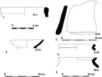
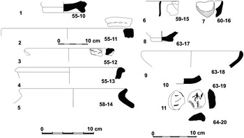
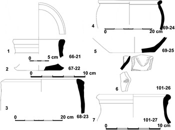
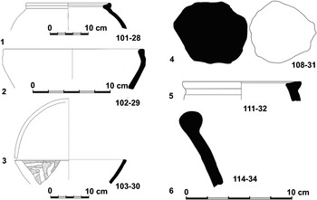
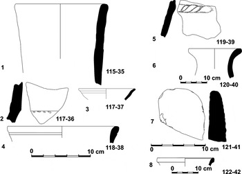
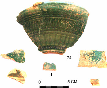
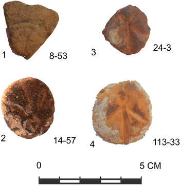
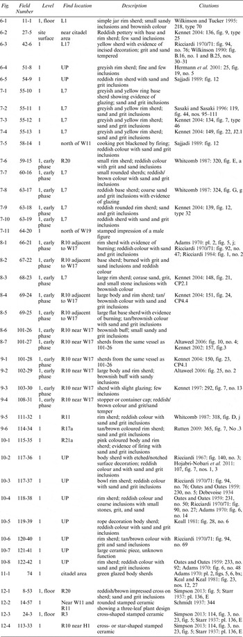
While in general the excavations yielded relatively few object finds, ceramic sherds have been recovered within the excavated structures, allowing the site to be dated. Examples of finds are listed in Figures 6–12, with descriptions and comparisons to comparable ceramics given in Table 1. In general, the majority of sherds appear to date to the Sasanian period, with stamped sherds and glazed ceramics (Figs. 11 and 12) being the most diagnostic. Colours of the non-glazed ceramics range from white-pinkish, red, pink, light red, yellowish-red, brownish-red, pale brown, reddish-grey, and light brown; however, reddish colours were predominant. Glazed ceramics are green. Pottery temper incorporates small stones, grit, or sand, while relatively few have no inclusions. A large proportion of the sherds appear to be from cooking or storage wares and are coarse tempered. Types of wares, however, include large storage jars, cooking wares and cups. Overall, 25 rim sherds, 5 base sherds, and 6 body sherds are decorated; most of the body sherds are globular and rim sherds generally are everted. One stamped sherd shows a male figure possibly standing next to a tree (Fig. 7, no. 11). While most of the sherds are plain or simply decorated, Figure 12 (nos. 1–4) shows stamped designs commonly found in the Sasanian period. One glazed ware is also diagnostic for this period (Fig. 11).
Ceramics from Merquly Level 1 (Field Numbers 11-1 to 54-9)

Pottery from Merquly Level 1 (Field Numbers 55-10 to 64-20)

Pottery from Merquly Level 1 (Field Numbers 66-21 to 101-27)

Pottery from Merquly Level 1 (Field Numbers 101-28 to 114-34)

Pottery from Merquly Level 1 (Field Numbers 115-35 to 122-42)

Green glazed ceramic (Field Number 74) found in the citadel in Level 1

Stamp-impressed clay objects (Field Numbers 8-53 to 113-33) showing crosses (1, 3–4) and a likely leaf design (2)

Descriptions of pottery shown in Figs. 6–12. In the find location column, UP is for unprovenanced.

A total of six pottery bases were found, with three being ring bases and the others simple flat bases. All of the flat bases were likely used as cooking vessels, and show evidence of burning (e.g. Fig. 8, no. 5), while the ring bases show evidence of being glazed (Fig. 7, no. 1 and no. 8). As the pottery is found in one building level, although probably with at least two building phases, we conclude the site dates to one period, with differences in periods not distinguishable based on the ceramics from different phases.
Many of the diagnostic ceramic finds, including their context, description, and close parallels, are listed in Table 1, with Figures 6–12 showing these key finds. While a few of the diagnostics could possibly be dated to the Parthian period (e.g., Fig. 10, no. 3 or 10, no. 6), the predominant forms appear to be more clearly Sasanian and, in fact, many of the Parthian types have also been found in Sasanian contexts (Ricciardi Reference Ricciardi1970/71; Kennet Reference Kennet2004). Therefore, without clearer evidence, we suggest that the site dates to the Sasanian period, possibly dating to the second half of the Sasanian period given the presence of the impressed crosses (Simpson Reference Simpson, Peruzzetto, Metzger and Dirven2013) that are found during this time in northern Mesopotamia. In fact, the best evidence for a Sasanian date comes from the Sasanian-style stamped sherds, comparable to finds from Nuzi and elsewhere (Starr Reference Starr1937: pl. 136, E; Schmidt Reference Schmidt1937: 342, 344; Simpson Reference Simpson, Peruzzetto, Metzger and Dirven2013: 114, fig. 3), and green glazed sherds (Fig. 11) that are common to the period (Keal and Keal Reference Keall and Keall1981: fig. 23, nos. 12, 27; Hill et al. Reference Hill, Speakman and Glascock2004). Figure 12, no. 2 appears to be a slightly unusual impressed ceramic style from this period, as this design is more often found in decorated stucco in Sasanian buildings (Schmidt Reference Schmidt1937: 342, 344).
Discussion and Summary
Overall, the site of Merquly appears to be a fortress that dates to the late Sasanian period. This appears to be supported by the ceramic finds evident at the site. The presence of a nearby rock relief provisionally dated to the late Parthian could suggest the site was constructed after the relief had already been made. We cannot exclude the possibility that an earlier Parthian phase is present at the site, perhaps associated with the relief found nearby, but a clear Parthian phase has not been ascertainable at this stage. Nevertheless, based simply on the finds, we have to conclude that Merquly is a Sasanid site, while the relation to the nearby rock relief is not entirely clear without further investigation.
From the ceramics, parallels, particularly for those examples shown in Figures 11 and 12, are found in relatively nearby sites from northern and southern Iraq (Starr Reference Starr1937: pl. 136; Ricciardi Reference Ricciardi1967; Adams Reference Adams1970; Ricciardi, Reference Ricciardi1970/71; Wilkinson and Tucker Reference Wilkinson and Tucker1995; Altaweel Reference Altaweel2006; Simpson Reference Simpson, Peruzzetto, Metzger and Dirven2013: 114, fig. 3, no.23) and Western Iran (Keal 1969; Keal and Keal Reference Keall and Keall1981). However, some of the general styles, as one might expect during a period when the Sasanian empire ruled a large area, show similarity to other regions, including other parts of Iran (Schmidt Reference Schmidt1937: 344; Whitcomb Reference Whitcomb1987; Sajjadi Reference Sajjadi1989; Kennet Reference Kennet2002; Hojabri-Nobari et al. Reference Hojabri-Nobari, Khosrowzadeh, Kouhpar and Vahdatinasab2011), Turkey (Wilkinson Reference Wilkinson1990), the Gulf (Sasaki and Sasaki Reference Sasaki and Sasaki1996; Kennet Reference Kennet2004), and Central Asia (Hermann et al. Reference Herrmann, Kurbansakhatov and Simpson2001). Similarities to these regions suggest Merquly likely has cultural similarities with more distant regions, but as scholars have indicated (Boucharlat and Haerinck 1992) there is still much to learn regarding regional variations and understanding of ceramic styles within the Sasanian period.
As for architectural similarities with other nearby regions and citadels/fortresses from the Sasanian period, so far no similarities with other sites are overtly evident, although this might be due to Merquly's relatively less well-preserved architecture. While the location and known architecture suggest Merquly served as a type of fortress, the functional nature of the site is still uncertain. Qal'eh-i Yazdigird is a site that is relatively near Merquly, located about 120 km to the south-east, and seems to have a comparable setting to Merquly, with the fortifications at Qal'eh-i Yazdigird potentially resembling Merquly and being located on an uneven elevated area in the Zagros. In the case of Qal'eh-i Yazdigird, the preservation is better and clear fortress towers are present (Keall Reference Keall1967, Reference Keall1982; Keall and Keall Reference Keall and Keall1981), although in the case of Qal'eh-i Yazdigird one of the fortresses is dated to the late Parthian period (Keall Reference Keall1977). There also seem to be fortress towers at Merquly, similar to Qal'eh-i Yazdigird, but the towers are not preserved at Merquly and a simple surface examination was not sufficient to determine their plan. Kala Dawar, a site near Qal'eh-i Yazdigird, is dated to Sasanian and later periods (Keall and Keall Reference Keall and Keall1981; Keal Reference Keall1982). This particular site does show a plan with a courtyard layout surrounded by long L-shaped corridors similar to what is apparent at Merquly (Fig. 3). Merquly could also be similar to Qasr-i Abu Nasr (Whitcomb Reference Whitcomb1985: 94), located in south-western Iran near Shiraz, which is a type of fortified town and fortress area, albeit that Merquly would likely be at a smaller scale. As Whitcomb points out in discussing Qasr-i Abu Nasr, such citadel and fortress sites are difficult to discern architecturally since often they can be products of numerous architectural phases influencing what actually remains and is evident in excavations. While only two main building phases are known at Merquly, it is possible that other phases have been missed or are difficult to discern archaeologically since other parts of the site have not been investigated. Future excavations along the identified possible tower areas could clarify the architecture. Overall, architectural comparisons are still tentative without further excavations.
Further clarifying the history of the site will be the primary goal in any future excavations of this site, including addressing the question of whether Parthian evidence can be found and linked to the relief in the area. The site's strategic location, on a height next to a pass going into the Permagroun, would suggest the area should have been important to fortify or protect in many periods, as the more recent Iraqi Army disturbances in the area themselves suggest. Overall, the presence of stone materials on the surface near to the excavated area does suggest that the citadel is probably part of a larger fortified complex.