Introduction
The sovietization of Russian science began in the Soviet Union in the early 1930s and was almost concluded before World War II. Repression and several campaigns against scientists created an atmosphere of fear in order to make scientists loyal to the Soviet regime. The next ideological step was to rewrite the history of world science on the basis of materials from the Soviet archives, in order to emphasise the prominence of Russian science in numerous scientific discoveries as well as in geographical studies. The Academy of Sciences of the Soviet Union (AS SU) took responsibility for this, as in, for example, 1947 when the Soviet Union took part in an international discussion on the invention of radio (Sonin Reference Sonin2011: 411–416, 433). The project had to be coordinated with the Secretariat of the Central Committee of the Communist Party of the Soviet Union (CPSU) (Osipov and Esakov Reference Osipov and Esakov2000: 391). On 11 January 1949, the general meeting of the AS SU accepted the Central Committee's ‘suggestions for ideological activities and Joseph Stalin's instructions concerning the revision of science history in the Marxist-Leninist [context],’ emphasising the ‘urgent need for improving and extending the activities in the fields of science history and technology’ (Postanovlenie. . . Reference Vavilov1949: 881).
In writing the ‘true history’ of science, the Russian expedition to the Antarctic in the nineteenth century (the official name was ‘premiere division partie’ (‘first squadron of sloops’) (compare de Traversay Reference de Traversay1819)) under the leadership of Fabian Gottlieb von Bellingshausen became one of the first ideological battlefields for Soviet researchers. On 9 August 1948, the United States of America called upon seven states that had made colonial claims to Antarctica (Argentina, Australia, Chile, France, New Zealand, Norway and United Kingdom) to give up their demands and together establish an eight power condominium to assume collective sovereignty over Antarctica (Berg Reference Berg1949: 4; Bulkeley Reference Bulkeley2013: 10). The Soviet Union was to be excluded from this collective. Such a proposal could not be met without a contest. On 29 January 1949, the CPSU decided that at first, it would be appropriate not to use official methods to draw attention to the rights of the Soviet Union to the Antarctic (Dokladnaya. . . 1950). This suggestion was included in the resolution of the meeting of the Soviet Geographical Society, convened especially for this purpose on the initiative of the CPSU on 10 February 1949 (Berg Reference Berg1949: 31–32). The Soviet Union's right to participate in political discussions about Antarctica was asserted on the grounds of the Bellingshausen expedition. This fact on its own, however, was insufficient to assert Soviet interests; a new version of the ‘exploration’ of the Antarctic continent, starting with the Russian Antarctic expedition, had to be planned.
This article discusses treatments of the Russian Antarctic expedition in the context of western, Russian and Soviet ideas about the Antarctic in the 19th and 20th centuries. The analysis focuses on the arguments put forward by Soviet scientists between 1945 and 1970 that the ice shelf (verge of the Antarctic continent) was first sighted and thus discovered namely by the Russian expedition. In this context, whether Bellingshausen and his contemporaries interpreted the nature of continental ice the same way that scientists of the twentieth century did is the decisive question. The answer would indicate whether it is correct to ascribe present-day knowledge to people from the nineteenth century; in the present case, concerning a continent that can consist of ice. Even today, a definitive claim over the ‘first exploration’ of the Antarctic continent depends on the answer to this question, which is political in nature. From a scientific and historical point of view, it would perhaps not be correct to give one definite answer. The article tries to contribute to the depolitisation of the history of Antarctic exploration.
General conceptions of the physical geography of the South Pole region before the 19th century
During his great voyage of 1519–1521, Fernando Magalhães discovered that south of the strait he had crossed (which opened a route from the Atlantic to the Pacific Ocean) was ‘Tierra del Fuego’. The following voyages under the leadership of Francis Drake, Jacob le Maire, William Dampier, Jacob Roggeween, Jean Baptiste Charles Bouvet de Lozier and Edmund Halley proved that the ancient conception of the large ‘Terra Australis’ was outdated and if it existed, then most probably in the region of the South Pole. The first to analyse the voyages to that extensive territory, in the past called ‘Terra Australis’, was the French encyclopaedist Charles de Brosses in his publication Historie des navigations aux Terres Australes of 1756. According to him, voyages to the region of the South Pole indicated that ice was encountered at very low latitudes. He interpreted that as the evidence of considerably more severe climate in this region, as compared to the North Pole. Brosses concluded that difficult ice conditions were the reason why a continent had not been yet discovered in the South Pole region (Brosses 1756: 1: 47, 69, 2: 314).
The famous British circumnavigator James Cook attempted to solve the question of the presence of a continent in the region of the South Pole during his second voyage around the world (1772–1775). Cook wrote in his travelogue: ‘Thus I flatter myself, that the intention of voyage has, in every respect, been fully answered; the southern hemisphere sufficiently explored; and an final end put to the searching after southern continent, which has at times, ingrossed the attention of some of the maritime powers, for near two centuries past, and been a favourite theory amongst the geographers of all ages. That there may be a continent, or large tract of land, near the pole, I will not deny; on the contrary I am opinion there is; and it is probable that we have seen a part of it. The excessive cold, the many islands and vast floats of ice, all tend to prove that there must be land to the South’ (Cook Reference Cook1777: 239). Some pages later Cook stated: ‘If any one should have resolution and perseverance to clear up this point by proceeding farther than I have done, I shall not envy him the honour of the discovery; but I will be bold to say, that the world will not be benefited by it’ (Cook Reference Cook1777: 243).
Cook supposed that his expedition had put an end to the speculations concerning the physical geography of the South Pole. Indeed, it partly had. In 1778, a close friend and colleague of Brosses, Georges-Louis Leclerc de Buffon, the most influential 18th century natural scientist, published in his voluminous work Histoire naturelle, générale et particulière special maps of the physical geographies of the North and South Poles with respective explanations added to volume 5 (Buffon Reference Buffon1778: 601–615). Relying on the data of severe climate by navigators who had been to the regions of the Arctic and Antarctic, he, as had some earlier authorities, reached a logical conclusion accepted by his contemporaries that the poles were permanently covered with ice. It means that he confirmed the view of Cook that there was no point in trying to find some economic benefit from the South Pole region. Describing the floating continuous ice sheet, Buffon applied a witty metaphor of cork (ice cap), comparing ice around both poles with ‘une calotte de glace solide & continue’ (Buffon Reference Buffon1778: 604). To the question whether there was a continent or a number of islands in the region of the South Pole, Buffon preferred not to answer.
Buffon's publications were widely known. One of the best experts on the Russian Antarctic expedition, Rip Bulkeley (Reference Bulkeley2014: 57–58), has pointed out that Buffon's ice cap hypothesis in the North and South Poles was cited in several publications and was even included in maps. But if the Russian Minister of the Navy, Jean-Baptiste Prevost de Sansac, Marquis de Traversay, who was the initiator of the Russian Antarctic expedition (July 1819–August 1821), had used Buffon's speculative hypothesis as the main source, the Bellingshausen expedition, probably, would have never taken place. De Traversay knew the publications of Cook and, relying on his data, was convinced that there was a continent in the region of the South Pole and it was possible to find it. That supposition encouraged Russians to launch the Antarctic expedition (de Traversay [Reference de Traversay1818–Reference de Traversay1819]; compare Tammiksaar and Kiik Reference Tammiksaar and Kiik2013).
Antarctic expeditions from the 1820s to 1920s
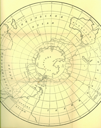
The origin, course and results of the Bellingshausen expedition on board the sloops Mirnyj and Vostok are well known today (Bellingshausen Reference Bellingshausen and Debenham1945; Rubin Reference Rubin1982; Bulkeley Reference Bulkeley2014), while the Soviet historiography of the Russian Antarctic expedition has been studied (Ovlashchenko Reference Ovlashchenko2014; Reference Ovlashchenko2016). The members of the Russian Antarctic expedition, Bellingshausen and the astronomer Ivan M. Simonov, accepted the opinion of Cook that it was impossible to determine whether the Antarctic continent existed (Nähere. . . 1821; Bellinsgauzen Reference Bellinsgauzen1823; Simonow Reference Simonow1824; Debenham Reference Debenham, Bellingshausen and Debenham1945; Bulkeley Reference Bulkeley2014). But, unlike Cook, the Russians discovered patches of terrestrial land, Peter I Island and Alexander I Coast, south of the Antarctic Circle in January 1821 (Fig. 1).
Map of the southern hemisphere with the islands discovered by the Russian Antarctic expedition (Bellinsgauzen, Reference Bellinsgauzen1831a). There is no remark on the discovery of the Antarctic continent.

During the Bellingshausen voyage the south polar regions were also visited by three mariners – in 1819 the English William Smith on the brig Williams and in 1820 Master in the Royal Navy Edward Bransfield with Smith in the same vessel and also the American sealer Nathaniel Palmer on the sloop Hero. They made discoveries in the northern part of the Antarctic peninsula. Smith discovered the South Shetland Islands in 1819, and these were further examined by Smith and Bransfield in 1820. During this examination Bransfield sighted, on 30 January 1820, terrestrial land west of the South Shetland Islands and named it ‘Trinity land’ (compare Gould Reference Gould1941). Palmer made his discovery on 17 November 1820 when he sighted Trinity land later named partly after him as Palmer Land (Balch Reference Balch1925; Debenham Reference Debenham, Bellingshausen and Debenham1945: xxiv). These as in the case of Bellingshausen's discoveries caused no big sensation in that time in European society.
After Bellingshausen's voyage, expeditions to the region of the South Pole continued. Many whalers and sealers visited South Polar regions (Headland Reference Headland2009: 123–154). In 1821–1824, the British sealer Benjamin Morell (Reference Morell1832) sailed in the southern polar waters; in 1822–1824, there was the British sealer James Weddell (Reference Weddell1827) and in 1830–1833, the British sealer John Biscoe (Reference Biscoe1833; Reference Biscoe and Murray1901).
The first Russian circumnavigator Adam Johann von Krusenstern (in Russian Ivan Fedorovich Kruzenshtern) was, until the 1830s, convinced that there was no continent present in the region of the South Pole (Krusenstern Reference Krusenstern and Kotzebue1821: 3; Reference Krusenstern1830; Kruzenshtern Reference Kruzenshtern1830: 106; compare Tammiksaar and Kiik Reference Tammiksaar and Kiik2013:181, 185, 188). Having learned about the discoveries of the British John Biscoe, Krusenstern wrote to Alexander von Humboldt in 1833: Bellingshausen's ‘discoveries at 69 South Latitude awoke interest again in connection with the discoveries of Capt. Biscoe [Enderby and Graham Lands] in the same region. It cannot be excluded that there is a connection with Capt. Bellingshausen's Alexander Land . . . If that appears to be true, it makes for the extent [of this land] over 900 miles and, no doubt, deserves to be called continent’ (Krusenstern Reference Krusenstern1833; B.[erghaus] Reference [erghaus, H.]1863: 11–12).
The captain Paul Theodor von Krusenstern (compare Keyserling, Krusenstern, Reference Keyserling and Krusenstern1843; Kruzenshtern Reference Kruzenshtern1879; Krusenstjern Reference Krusenstjern1982: 1–10) wanted to check his father's supposition. In 1833, he met James Clark Ross at Kronshtadt, who planned an expedition to the South Pole and invited Krusenstern to join it. But he refused as he dreamed of organising his own expedition to these areas but failed (Perneder Reference Perneder1990: 82–83).
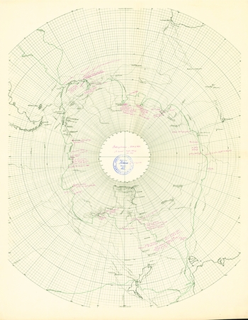
After Biscoe visited the South Polar regions in 1837–1840, the British sealer John Balleny (Reference Balleny1839); in 1838–1841, the French circumnavigator Jules Sebastién César Dumont d'Urville (Reference Dumont d'Urville1987); in 1838–1839, the American captain Charles Wilkes (Reference Wilkes1844a); and in 1839–1841, the British sailor and scientist James Clark Ross (Reference Ross1847) also explored in the area. Discoveries made during these expeditions were similar to those of the Bellingshausen expedition; new separate patches of terrestrial land were added to the maps of the region in the southern hemisphere (Fig. 2).
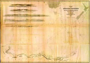
Charles Wilkes (Reference Wilkes1844b) was the first who stated that he had discovered Antarctica. His discovery was depicted in the ‘Chart of the Antarctic Continent described as an icy barrier discovered by Charles Wilkes 1840.’

The J.C. Ross expedition in 1841, however, discovered a large landmass with high mountains. Victoria Land, and ‘ice barrier’ were more prominent than the patches of terrestrial land discovered during previous expeditions. Numerous discoveries changed the general situation, and more people, such as Wilkes (Reference Wilkes1844a), member of the J.C. Ross’ expedition Robert McCormick (Reference M'Cormick and Ross1847), geologist Gregor von Helmersen (in Russian Gregor Petrovich Gel'mersen), geographer Leopold von Schrenck (in Russian Leopol'd Ivanovich Shrenk), astronomer Otto Struve, geophysicist Emil Lenz (in Russian Emilij Khristianovich Lents) (Smirnov Reference Smirnov1998: 51) and John Murray (Reference Murray1886) began speculating on the existence of a continent in the south.
Others, especially the cartographers August Petermann (Reference Petermann1850; Reference Petermann1863a) and Alexander Keith Johnston (Reference Johnston1848), Bellingshausen's companion Simonov (Reference Simonov1844), meteorologist Matthew Fontaine Maury (Reference Maury1860: 463–479), Ferdinand von Wrangell (in Russian Ferdinand Petrovich Vrangel’) (Smirnov Reference Smirnov1998) and geophysicist Georg Neumayer (Reference Neumayer and Michov1885, Reference Neumayer and Kollm1896a, Reference Neumayer1896b) speculated over the question of sea or archipelago behind the ice barriers in the region of the South Pole. Those who were more cautiously inclined left questions open about the existence of a continent or a sea. The fact that most of the seafarers in the 19th century saw ice in the south made the problem even more complicated, as they did not find a logical explanation for the origin of such high ice masses, whether they had been formed on the mountainous continent, in the sea, or between islands. Each explorer put forward his own argument. In terms of today's knowledge, their assumptions were not accurate (Wilkes Reference Wilkes1844a: 349–354; d'Urville Reference Dumont d'Urville1987: 479–488; Ross Reference Ross1847: 274–275).
For Russian scientists, as well as their European colleagues, it was difficult to establish what there was in the South Pole region. However, although reliable knowledge of the physical geography of the South Pole region was scant, this did not bother those who believed in the existence of a continent there and, depending on their nationality, people considered Wilkes, d'Urville, or J.C. Ross as the first explorer of Antarctica. Among them, Ross was even in Russia considered to have contributed the most to the exploration and discovery of the Antarctic (Otkrytie. . . 1842: 48–52; Baer Reference Baer2001: 45; Seybt Reference Seybt and Ross1847; V; Kämtz Reference Kämtz1848: 85–88; Lenz Reference Lenz1858: 45; Nordman Reference Nordman1877: 8; Smirnov Reference Smirnov1998: 46–54). Pavel M. Novosil'skij, an officer on Mirnyj, was probably very disappointed that the discovery of the Antarctic continent by the Bellingshausen (he died in 1852) expedition was not mentioned in his obituaries (Anonymous 1853; Milyutin Reference Miljutin1853: 6; Zhizneopisanie. . . 1853). That may be the reason why Novosil'skij very soon after the obituaries published two pamphlets, The sixth continent, or, a brief account of voyages to the south from Cook to Ross ([Novosil'skij] Reference Novosil'skij1854) and a diary entitled South Pole ([Novosil'skij] Reference Novosil'skij1853) claiming publicly, for the first time in Russia, that Russians, who discovered the Alexander I Coast in January 1821, should be considered the pioneers of the Antarctic continent. He wrote: ‘. . . until the present day, neither in Russian nor in foreign languages, has there appeared any special study on the southern continent [which I have compiled] and the first discovery of it rightly belongs to Russian navigators’ ([Novosil'skij] Reference Novosil'skij1854: 17).
Novosil'skij was elected a member of the Russian Geographical Society on 11 February 1854 and in the same year he wrote his book The sixth continent (Otchet. . . 1855: 5, footnote 1; 71). Next year, on 25 April 1855, he presented his conclusions to the general meeting of the geographical society (65 members were present) (Obshchee. . . 1855: 20). Friedrich Benjamin von Lütke (in Russian Fedor Petrovich Litke), the first vice-president of the Russian geographical society, did not agree with Novosil'skij's statements and probably initiated a critical discussion on this question after the presentation. We know Lütke's views thanks to his letter (January 1856) to the secretary of the St Petersburg Academy of Sciences. The Academy had commissioned Lütke to review Novosil'skij's books for the Demidov's Prize awards (Dvadtsat’. . . 1856) and in this letter he severely criticised Novosil'skij's statement and his publications. Lütke wrote: ‘. . . now, after all the discoveries made in recent times [in the southern areas], and especially after the discovery of the Antarctic continent, interest in Bellingshausen's discoveries is fading. . . . This expedition had no scientific value, as no scientists took part in that and sailors only made their every-day ordinary observations’ (Lütke Reference Lütke1856: 3). Obviously, that disapproval by Lütke after the presentation was the reason why Novosil'skij changed his attitude in his next article (Otchet. . . 1856: 53) writing at the end of 1855: ‘Are all these coasts [discovered during the 19th century] emerging [in the region of the South Pole] parts of a continuous continent or, vice versa, are these different lands? This question will be solved by navigators sailing in the polar sea in the future’ (Novosil'skij Reference Novosil'ski1855: 30).
Novosil'skij's statements were almost forgotten in Russia (except in [Russwurm] Reference Russwurm1870: 17; G[ershau] 1892: 373, 381) until 1949 (Ostrovskij Reference Ostrovskij1949). However, the claim that the Russian expedition had discovered the Antarctic continent upon the discovery of the Alexander I Coast in January 1821 attracted more attention after expeditions by the Belgian (Adrien de Gerlache de Gomery 1897–1899), the British (Carsten Borchgrevink 1898–1900; Robert Falcon Scott 1901–1903; Ernest Shackleton 1908), the German (Erich von Drygalski Reference Drygalski and Kollm1901–1903), the Swedish (Otto von Nordenskiöld 1901–1903), and the French (Jean-Baptiste Charcot 1904–1907) explorers yielded evidence of the existence of an Antarctic continent consisting mainly of continental ice. This was supported by the famous Russian geographer Lev Berg (Reference Berg1929: 47, Reference Berg1946: 109) as well as other Russian authors (Rabinovich Reference Rabinovich1908: 5; Vvedenskij Reference Vvedenskij1940: 46; Reference Vvedenskij1941: 121; Shister Reference Shister1948: 9).
Such an approach was still not dominant in Russia in the first half of the twentieth century. The Bellingshausen expedition did not result in the discovery of Antarctica, but it was considered very important in the exploration of southern polar areas in the 1840s, although this expedition was not the immediate trigger for the understanding of Antarctica as a continent (Shpindler Reference Shpindler1903: 281; Grigor'ev Reference Grigor'ev1937: 15; Raikhenberg Reference Raikhenberg1941). The most important supporter of this view was another Russian geographer, Yulij Shokal'skij (Reference Shokal'skij, Arsen'ev and Petrushevskij1898; Reference Shokal'skij1902; Reference Shokal'skij1928: 191).
The question of the Antarctic continent and ice age theory
Until today, in the explanation of the nature of the Antarctic continent, attention has not been paid to the ice age theory developed in the 19th century. That, however, is important as since 1949, thanks to Admiral Evgenij Evgen'evich Shvede (Reference Shvede, Bellinsgauzen and Shvede1949: 27, Reference Shvede, Bellinsgauzen and Shvede1960: 38), the conception that Bellingshausen and Lazarev understood the nature of the ice continent and thus can be correctly considered the discoverers of the Antarctic continent began to gain ground in Soviet publications. Tobias Krüger (Reference Krüger2013) has pointed out that in the history of geology the question of the extension of glaciers from the Alps to different regions of Europe was discussed as early as the 18th century. The main question was how erratic blocks were transported long distances from their original places. At first the transportation was not considered to be connected with past changes in the climate of the Earth. The theory of ice ages, partly based on meteorological and geological field observations in the Alps, attracted greater attention among European scholars thanks to the Swiss scientists Ignatz Venetz (Reference Venetz1833), Jean de Charpentier (Reference Charpentier1835) and Louis Agassiz (Reference Agassiz1837a, Reference Agassiz1837b; Agassiz and Bettannier Reference Agassiz and Bettannier1840). It means that Bellingshausen and Lazarev did not know the ice age theory when writing their works. They, after all, were not scholars (although they have been specified in this way), but navigators who had to carry out certain tasks.
Bellingshausen, probably, first learnt about the ice age theory in September 1842 when Karl Ernst von Baer (in Russian Karl Maksimovich Bér), member of the St Petersburg Academy of Sciences, applied to him as head of the port of Kronshtadt for renting a boat for a trip to islands of the Gulf of Finland (Baer Reference Baer1842; Sukhova and Tammiksaar Reference Sukhova and Tammiksaar2015: 38; footnote 30). He wanted to show Alexander Theodor von Middendorff (in Russian Aleksandr Fedorovich Middendorf) the traces of the glacial era in these islands. Baer hoped that Middendorff (who was appointed the leader of a Siberian expedition organised by the Academy of Sciences in 1842–1845) would, as a result, better appreciate indicators of former glaciation in Siberia (Tammiksaar Reference Tammiksaar2002: 132). Whether Bellingshausen drew on this basis any conclusions concerning his earlier observations in the region of the South Pole, the data at our disposal do not provide an answer.
It is noteworthy that the naturalists who proved the existence of ice age in the history of Europe, Siberia and Middle Asia were not very much interested in field study to establish the reasons of the drift of real glaciers. They tried to establish former boundaries of continental ice with the help of geological data available (Drygalski Reference Drygalski and Kollm1896: 25). As geological traces of the glacial epoch in Siberia with its severe climate, as in several places in Europe, were contradictory, the theory was not accepted with enthusiasm (Sukhova Reference Sukhova2000). On the contrary, it took a long period, from 1840s to 1870s, to prove the validity of the ice age theory. It was mainly the Swedish geologist Otto Martin Torell, who studied the phenomenon of glaciers in Switzerland, Spitsbergen and Greenland in the 1850s and later proved that the glacial era also existed in Scandinavia and several other places in Europe (Krüger Reference Krüger2013: 320–331).
Since the theory of the glacial era was acknowledged, it was often emphasised in scholarly literature that the ice age still exists in the Arctic and Antarctic (Ratzel Reference Ratzel and Michov1885: 17). That was a theoretical conception. Only the drift of Alpine glaciers at the place had been studied, not the drift of continental glaciers. Thus the physical preconditions and possibility of the movement of inland ice was in practice unknown. The first important attempts in the study of the physical laws of its movement were made by the Dane Hinrich Rink in Greenland in 1848–1851. Adolf-Erik Nordenskiöld carried out similar studies in the same region in the 1870s. The German geographer Erich von Drygalski measured in practice the movement of inland ice in Greenland in 1892–1893 and discovered numerous indicators of the principles of their drift (Lüdecke Reference Lüdecke2015: 16–23).
By the time that Drygalski carried out his Greenland expedition, the voyages by Wilkes, d'Urville and J.C. Ross had become history. Only the Challenger expedition of 1872–1876 made a short visit to the South Pole region (Neumayer Reference Neumayer and Kollm1896a: 12). In contrast to Greenland, which Nansen had crossed in 1888, nobody reached the inland area of the Antarctic before the 20th century. The only reliable data available was temperatures for summer periods and this was too scanty for providing a definite answer about the physical geography behind ice-barriers discovered by J.C. Ross, Wilkes and d'Urville (Drygalski Reference Drygalski and Kollm1896: 18; Fricker Reference Fricker1898: 222; Reference Fricker1904). It was still unknown whether there was a mountainous continent (Murray Reference Murray1886; Markham Reference Markham and Kollm1901) or an ocean mostly covered with ice behind the glaciers (Neumayer Reference Neumayer and Michov1885).
Numerous public lectures delivered by the German geophysicist Georg Neumayer since 1865 with the aim of encouraging the exploration of southern polar areas bore fruit thirty years later (Neumayer Reference Neumayer1901). In July 1895, Neumayer participated in the Sixth International Geographical Congress in London, where he had been invited by John Murray, former researcher of the Challenger expedition. He made a very detailed report about the tasks and importance of the study of southern polar areas (Neumayer Reference Neumayer1896b). Before the London congress, German geographers had gathered in Bremen where the launching of the German expedition to the south was on the agenda. In addition to Neumayer, Drygalski also prepared a report in which he suggested that the methods he had applied in inland ice studies in Greenland should also be used in the Antarctic. His idea was to point out the origin of different types of sea ice in order to establish the occurrence of glaciation in inland areas (Drygalski Reference Drygalski and Kollm1896). Neumayer acquainted the delegates in London with the purposes of Drygalski's studies as well as the report of Friedrich Ratzel (Reference Drygalski and Kollm1896) who also underlined the need to study glaciers in the region of the South Pole (Neumayer Reference Neumayer1901: 400–409).
It was, in the first place, thanks to Drygalski that the study of glaciers in southern polar areas had become topical since 1895 (Drygalski Reference Drygalski1898; Reference Drygalski and Kollm1901). The meteorological data collected during the wintering of the Belgian Antarctic expedition (1897–1899) under the guidance of Adrien de Gerlache at last provided some evidence of the existence of the Antarctic continent covered with glaciers (Supan Reference Supan and Murray1901a, Reference Supan and Kollm1901b). Drygalski, the leader of the first German Antarctic expedition (1901–1903), devoted effort to the study of the inland ice of the Antarctic (Drygalski Reference Drygalski1904). Similarly to Nansen in Greenland, Shackleton's Nimrod expedition (1907–1909) proved finally that the whole territory along which it progressed from the sea to the South Pole was a large high ice sheet and there stretched an ice continent, not an ice-covered sea (Shackleton Reference Shackleton1911).
Americans, British and Russians declare themselves discoverers of Antarctica
By the beginning of the 1920s, when the existence of the ice continent was evident, Wilkes, J.C. Ross, and d'Urville were no longer considered to have discovered the Antarctic continent. In the first half of the 20th century, scientists of the United States of America and Great Britain argued who had the honour of having discovered the Antarctic continent. Neither of these could boast of the discovery of some continent, while the Spanish had discovered America and the Dutch had discovered Australia. The Antarctic continent provided an opportunity. Expeditions making for the region of the South Pole at the beginning of the 20th century had to find reliable proof concerning the existence of a continent in the southern hemisphere.
Americans, however, had a problem. Although Wilkes was the first to declare himself the discoverer of the Antarctic, J.C. Ross and d'Urville had raised a doubt about his discovery and that was widely known (Fig. 3). So in 1902, Edwin Swift Balch (Reference Balch1902: 72, 174) in his book Antarctica tried to diminish the position of J.C. Ross who was mainly accepted as the discoverer of Antarctica and had pointed out that the American sealer Nathaniel Palmer could have discovered it on 17 November 1820 (Balch Reference Balch1902: 91). However, according to an article published by Rupert Thomas Gould in 1925, Bransfield, rather than Palmer, saw Antarctica first (Gould Reference Gould1925). The debate on who was the first to see Antarctica became heated between Balch (Reference Balch1925) and his supporters (Anonymous. . . 1911; Hobbs Reference Hobbs1939, Reference Hobbs1941; Martin Reference Martin1938, Reference Martin1940) and Gould (Reference Gould1941) and his adherents (ARH 1939; Hinks Reference Hinks1941; Campbell Reference Campbell2000: 132–133).
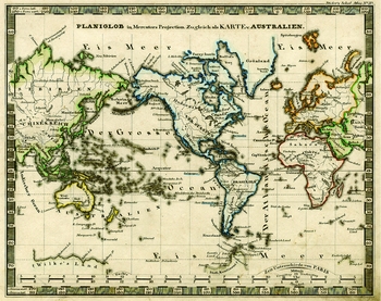
The exploration results of Wilkes were considered unreliable after the publication of results by Ross and d'Urville. That fact is well illustrated by the world map in the school atlas published in Germany in 1846 where there is a question mark placed on the lands discovered by Wilkes (Schul-Atlas 1846).

In the debates between Americans and British the question that the honour of the discovery of the Antarctic continent could belong to the Russian Antarctic expedition did not arise (except for Martin Reference Martin1938). The main reason, probably, was that Bellingshausen's travelogue was published only in Russian and in very small number (a print run of 600). Already in 1833, Alexander von Humboldt had expressed his regret to the cartographer Heinrich Berghaus that the Bellingshausen travelogue had been published in the ‘unknown to us Russian language’ (B[erghaus] Reference [erghaus, H.]1863: 11–12). In 1842, some data of the expedition were published in German (Löwe Reference Löwe1842), but they did not provide an adequate picture of the course of the expedition and especially the ice observations made during it. By the middle of the 19th century, the Bellingshausen book (Reference Bellinsgauzen1831b) had become a rarity even in Russia. August Petermann was successful in procuring one in 1863. After receiving it, he wrote in his registration book: ‘Bellingshausen expedition in Russian in one volume plus album and atlas in folio – the second copy of the library of the Russian Ministry of the Navy (received from Grand Duke Konstantin [Nikolaevich, Commander-in-chief of the Russian Navy and president of the Russian Geographical Society]). Very rare, impossible to provide in some other way’ (Petermann Reference Petermann1863b).
A more complete German translation of Bellingshausen's entire voyage narrative was published in 1902 (Bellingshausen Reference Bellingshausen1902), when interest in former voyages and their results in the southern polar waters started to arise connected with new expeditions there, but it was unavailable in English. Robert Falcon Scott wrote in 1905: ‘Bellingshausen was the first definitely to discover land within the Antarctic Circle. . . . Unfortunately, little is known of Bellingshausen's voyage, as the narrative was never translated into English from the original Russian’ (Scott Reference Scott1905: 10). Numerous other explorers of southern polar areas and those writing on exploration history reached the same conclusions (Fricker Reference Fricker1898: 41; Reference Fricker1904; Cook Reference Cook1901: 36; Balch Reference Balch1902: 83; Mill Reference Mill1903: 151; Reference Mill1905: 114–130).
Interestingly, Soviet scientists did not do anything noteworthy in the 1920–1930s for the study and propagation of Bellingshausen's legacy. Meanwhile, Soviet Russia was mainly interested in preparations for the Second International Polar Year (1932–1933) to guarantee its geopolitical interests in international scientific collaboration in northern polar areas (Lüdecke and Lajus Reference Lüdecke, Lajus, Barr and Lüdecke2010). It is not surprising, then, that when the part of the Antarctic coastline named Kronprinsesse Märtha Land, to which the Bellingshausen expedition had been quite close on 28 January 1820, was discovered by the Hjalmar Riiser-Larsen expedition in 1930, the Russians did not ascribe much official attention to it until 1939 (Razdel. . . 1939).
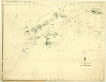
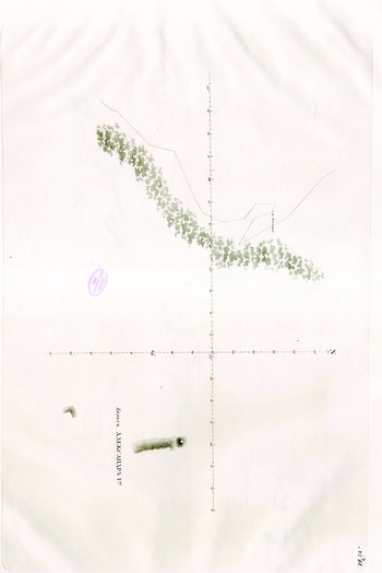
Bellingshausen's volume in English was printed in 1945. The preface and commentaries of the English book were written by Frank Debenham, director of the Scott Polar Research Institute, who had been interested in Bellingshausen's work in 1920s (Debenham Reference Debenham1923: 189). His work, based on the available knowledge of the physical geography of the Antarctic continent in 1930s, indicated to Soviet researchers indirectly that the key to when Antarctica was first sighted did not lie in the discovery of Alexander I Coast in January 1821 or on 17 February 1820 (Bellingshausen Reference Bellingshausen and Debenham1945: 128, footnote), but rather in the date 28 January 1820, when the Russian expedition had made the first attempt to approach the South Pole through ice. Debenham described that as follows in a footnote: ‘This day must be considered an unfortunate one for the Russian expedition, for we know now that they must have been within a few miles, not more than twenty at most, of the coast of what is now called Princess Martha Land, discovered in 1929–30 by the Norwegian expedition. It is even possible that the “solid stretch of ice running from east through south to west” was indeed the land ice which, everywhere along this coast, marks the edge of the continent. In any case, a few hours of clear weather on this day would have certainly antedated the discovery of land here by 110 years’ (Bellingshausen Reference Bellingshausen and Debenham1945: 117 footnote 2). The fact that Bransfield discovered the extreme northern portion of the mainland of the Antarctic Peninsula, as proved by the British in the late 1930s, named Trinity Land, on 30 January 1820 made the situation even more complicated (Fig. 4). In 1947, Rear Admiral Evgenij E. Shvede published a review of this book in the journal of the Russian Geographical Society, in which he did not dispute Debenham's statements (Shvede Reference Shvede1947), but there is a high probability that he did not read it very carefully.
The map of British discoveries in the region of the Islands of South Shetland and South Orkney (today that region also includes the Antarctic peninsula) compiled by the Department of Hydrography of the British Admiralty in 1844. It follows from the map that at that time the British did not regard the discoveries of Bransfield and others as the discoveries of the continent (there is no respective word on the map) (Kartensammlung Perthes. Erfurt. 547$111789869).

The great political game had not yet started as the Americans undertook their démarche in 1948. As a result, Bellingshausen's expedition, the discoveries made, and writings and other issues became very important to political authorities. Due to that, the Palmer-Bransfield discussion and the book by Debenham were studied more thoroughly by Soviet geographers at the beginning of 1949. A hasty study of Russian-language archival documents and literature provided plenty of material proving that it was certainly the Russian Antarctic expedition that discovered the Antarctic continent (Berg Reference Berg1949: 17).
On 10 February 1949, a general assembly of the Geographical Society took place. Berg, president of the Society, relayed the main report (Berg Reference Berg1949: 4–20). To strengthen the political message, he spoke about the view of James Cook (that is, that it was impossible to see a continent/land in the Antarctic because of complicated ice conditions) which had hindered further exploration in the Antarctic, and that brave Russian seafarers had refuted such a misleading view. After this report, it became very important to Soviet researchers to prove that Cook's expedition had denied the existence of a continent in the south. Such political allegations were explicitly expressed in the publisher's preface to the book The voyage of the sloops ‘Vostok’ and ‘Mirnyj’ to the Antarctic in the years 1819–1821 published in 1949. It reads: ‘Russian explorers sailed to the southern hemisphere with a special aim to discover lands in the vicinity of the South Pole after it had been completely assumed in the West [by Cook] that the South continent did not exist. The discovery [did] take place’ (Anon. Reference Andreev1949: 3). In this way, the communist Soviet Union brought discredit upon the capitalist west.
It was also important to prove that the honour of discovering the Antarctic continent first belonged to Russia. In his report, Berg highly valued Debenham's data and suggested that the rough ice described by Bellingshausen on 28 January 1820 was actually the verge of the Antarctic continent (Berg Reference Berg1949: 12; 18–19). However, Berg did not declare that Bellingshausen had assumed that he had discovered the Antarctic continent on that day; as an experienced historian of geography, Berg knew that in such circumstances, it would be too provocative to assume so (Fig. 5). Some other distinguished Soviet geographers, such as Andrej A. Grigor'ev and D. M. Lebedev (Reference Grigor'ev and Vavilov1949), Aleksandr I. Andreev (Reference Andreev and Andreev1949a) and Stanislav V. Kalesnik (Reference Kalesnik1949), also used Debenham in their articles to show how highly they valued Bellingshausen's observations. Admiral Shvede also participated in the general assembly and, relying on Debenham, noted that the discoveries of the Bellingshausen expedition should not be limited to the officially recognised discoveries of Peter I Island and Alexander I Coast in 1821. Specifically, it should be acknowledged that the expedition repeatedly approached the Antarctic continent and, judging by the descriptions presented by Bellingshausen, he had certainly seen Antarctica considerably earlier than what was assumed (Berg Reference Berg1949: 24). In this way, Shvede recognised that there was a serious problem for Soviet geographers, and encouraged the proving that it was the Russian Antarctic expedition which discovered the Antarctic continent.
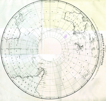
The map of the voyage of the Russian Antarctic expedition around Antarctica compiled by Soviet geographers and published in 1949. It is remarkable that the boundaries of the Antarctic continent have been indicated in the map due to which it was accepted as a proof of the discovery of the continent by the expedition (Berg Reference Berg1949).

Since prominent Russian geographers Berg, Grigor'ev, Andreev, and Kalesnik were not completely successful in solving the problem, Shvede tried to do it himself by creating a different account of the Russian Antarctic expedition. In 1949, on his initiative, the second edition of Bellingshausen's narrative was published in Russian. A critical analysis of the available archival documents and published materials in the introduction to the book indicated that he was convinced that Bellingshausen could not see the Antarctic continent on 28 January 1820 due to bad weather. He compared the observation data of the second Soviet whale flotilla Slava (Gan Reference Gan2011) of 20 March 1948 in clear weather with those from the Bellingshausen expedition on 2 February 1820, and deemed them similar. Thus, Shvede wrote: ‘If the visibility had not been bad, Bellingshausen and Lazarev would already have secured data on the Antarctic continent on 28 January 1820’ (Shvede Reference Shvede, Bellinsgauzen and Shvede1949: 26).
Books about the first (1946–1947) and the third (1948–1949) trip of the first Soviet Antarctic whale hunting flotilla have been published (Shister Reference Shister1948; Reference Shister1949) but not on the second Slava expedition. There is only one report by Georgij M. Tauber (Reference Tauber1949) and it appears that the abstract (not appropriate to the text) describing the approaching of the Antarctic continent by Slava on 20 March 1948 in the region (69°25′S and 1°11′W) where the Russian Antarctic expedition had been on 2 February 1820, was added later. The Antarctic continent was that day clearly seen from Slava (Tauber Reference Tauber1949: 370). It is not known whose idea it was to include that paragraph in the text. But the fact that in March 1948 the question of the discovery of the Antarctic continent on 28 January 1820 was not on the agenda (otherwise Slava would have been sent straight to that position) can provide an answer. It is more probable that it was pure chance that Slava reached the region of Kronprinsesse Märtha Land.
Nevertheless, Soviet authors tried to portray the Russian Antarctic expedition as having discovered the Antarctic continent on 28 January 1820, although the publications of the materials about the expedition containing Bellingshausen's texts (Bellingshausen Reference Bellingshausen and Debenham1945: 117; Bellinsgauzen Reference Bellinsgauzen and Shvede1949: 110) (Fig. 5), notes by Egor Kiselev, a sailor aboard Vostok under the command of Bellingshausen himself (Andreev Reference Andreev1949b; Tarnopol'skiy Reference Tarnopol'skij1941; Bulkeley Reference Bulkeley2014: 130–140), and the diary by Pavel Novosil'skij (Reference Novosil'skij1853: 28–29), sailing as an officer on Mirnyj, proved well that the navigators had not seen anything special on that day. This was also well known in the west (Armstrong Reference Armstrong1950; Reference Armstrong1951; Reference Armstrong1971).
First, on 17 February 1820, the ‘verge of continental ice’ was sighted by the Russian Antarctic expedition. On 20 April 1820, Bellingshausen wrote in his report to the Minister of the Navy: ‘17th and 18th [February 1820], I reached latitude S 69°7′30″, longitude E 16°15′. There, beyond ice fields comprising small ice and [ice] islands, a main of ice [‘materik l'da’] was sighted, the edges of which had broken away perpendicularly, and which stretched as far as we could see, rising to the south like land’ (Bellinsgauzen Reference Bellinsgauzen1823: 212; Samarov Reference Samarov1952: 147; translated Bulkeley Reference Bulkeley2014: 83).
To maintain the prominence of the Russian expedition over the American (Palmer) and British (Bransfield) expeditions, the Soviet researchers had to find a source that differed from the notes of other expedition members on the same date.
‘Materoj led’, ice age and the first sight to Antarctica
Such a source already existed: from Mikhail P. Lazarev, captain of Mirnyj. Lazarev's letter to a friend from 15 September 1821 was published in the Russian Navy journal in 1918, describing the course of the voyage as follows: ‘On 28th January we reached latitude 69°23′S, where we met main ice [‘materoj led’] of extraordinary height. It was a fine evening, and looking out from the crosstrees it stretched just as far as our gaze could reach, but we had not long to enjoy that amazing spectacle, because the murk quickly came over again and the usual snow set in’ (Pis'ma. . . 1918: 55; Andreev Reference Andreev1949b: 21; Samarov Reference Samarov1952: 150–151; English translation Bulkeley Reference Bulkeley2014: 168).
Thus Bellingshausen as well as Lazarev, both used for describing ice what was seen very similar terms ’materik l'da’ (Bellinsgauzen Reference Bellinsgauzen1823: 212; Samarov Reference Samarov1952: 147) or ‘materoj led’ (Bellinsgauzen Reference Bellinsgauzen and Shvede1949: 118; 310; Pis'ma. . . 1918: 55; Samarov Reference Samarov1952: 150–151), in Soviet Antarctic literature known as ‘ice continent’. Thus these terms are playing a key role in the exploration history of Antarctica. What two captains meant when used these expressions?
The similarity of terms may have resulted in a discussion that took place during a lunch on 20 February 1820 on board Vostok, three days after the sight of ‘materik l'da’ according to Bellingshausen (Bellinsgauzen Reference Bellinsgauzen1823: 212; Reference Bellinsgauzen and Shvede1949: 120). We know about this lunch thanks to the navigation chart of the Russian Antarctic expedition (Belov Reference Belov1963: 33). We can only imagine the perplexity of two captains and the officers of both ships on 20 February when they discussed such an unexpected and magnificent sight. Nobody, not even James Cook, had encountered anything like that during his voyage to the south. This was quite different from Buffon's speculative ice cap hypothesis, in the event that they knew that, but rather slightly. So it is clear that the descriptions of ice in the Antarctic seas published by Bellingshausen in 1831 were not always understandable to his contemporaries. In the first German translation of Bellingshausen's work (1842), the translator had not translated all the long descriptions of the sight, for example ‘materoj led’ on 17 and 18 February (Löwe Reference Löwe1842: 139). In the English translation of 1945, ‘materoj led’ was translated as ‘high icebergs’ and ‘mother-icebergs’ (Bellingshausen Reference Bellingshausen and Debenham1945: 128, 417), not as ‘ice barrier’ now named as the ‘verge of continental ice’ (Wilkes Reference Wilkes1844 a: 354; J.C. Ross Reference Ross1847: 228). Bulkeley (Reference Bulkeley2014: 54–60) in his book Bellingshausen and the Russian Antarctic expedition, 1819–21, has used, in his translation of Bellingshausen's and Lazarev's texts, the term ‘main ice’, used by John Ross (Reference Ross1819) (very similar to the term of Buffon ‘ice cap’ and his follower William Scoresby's (Reference Scoresby1818) ‘continuous field of ice’ 6 or 7 m thick). Thus, the term ‘materoj led’ is very confusing and there are different translations for this term.
Bulkeley (Reference Bulkeley2014: 58) has pointed out that astronomer Simonov knew Buffon's hypothesis. But from his texts it follows that during the voyage Simonov had no special interest in ice and its types (Simonov 1822; Simonow 1825; compare Bulkeley Reference Bulkeley2014: 144–158). When the naval officers Bellingshausen, Lazarev, Novosil'skij and even the sailor Kiselev (compare Bulkeley Reference Bulkeley2014: 13B3) paid in their notes attention to the magnificent sight on ‘the verge of continental ice’, then Simonov, the only scientist on the expedition, did not. That raises a serious question about his position on the ships during the voyage. He seemed not to belong to the close company of officers of the expedition and thus could not take part in common discussions on board, meaning that his ideas did not influence the views of other expedition members.
But what about the terms ‘materoj led’ and ‘materik l'da’ themselves? There seem to be several reasons, such as the extraordinary height of the ice, its extension far beyond the horizon and rising to the south like a coast of land why Bellingshausen used the term ‘materik l'da’ in his report to the Minister of the Navy in April 1820 (Bellinsgauzen Reference Bellinsgauzen1823: 212; compare Bulkeley Reference Bulkeley2014: 83). He could not provide another adequate description as compared to solid ground. According to the first Explanatory dictionary of the Russian language by Vladimir Dal’, in the nineteenth century, the word ‘materik’ was used in a geographical context as a general term for ‘solid ground’ (from island to continent) (Dal’ Reference Dal’1881: 311). In Dal's Dictionary it is also denoted that ‘materik’ can also mean the height of a coast, a slope of a river, or a mountain, as opposed to level relief (Dal’ Reference Dal’1881: 311), for example, to sea level.
Interestingly P. Novosil'skij (Reference Novosil'skij1853: 30) who took part in the lunch on 20 February 1820 did not use the term ‘materik’ in his diary but the term ‘ledyanoj bereg vysokimi otvesnymi stenami’ (‘ice coast with high vertical walls’). Did he use this expression because was so strong in Russian terminology or he had read the expedition results of Ross and Wilkes, which were published in his booklet The sixth continent, or, a brief account of voyages to the south from Cook to Ross ([Novosil'skij] Reference Novosil'skij1854)? Still it seems that Novosil'skij wrote differently from Bellingshausen and Lazarev first of all under influence of Ross, who discovered ‘a perpendicular cliff of ice between one hundred and fifty and two hundred feet [46–61 m] above the level of the sea, perfectly flat and level at the top’ (Ross Reference Ross1847: 218). Ross (Reference Ross1847: 219) continued in his book: ‘The whole coast here from the western extreme point [Parry Mountains], now presented a similar vertical cliff of ice, about two or three hundred feet [61–91 m] high.’ Ross called his discovery ’Great Icy Barrier’ (Ross Reference Ross1847: 208). Novosil'skij translated this into Russian as ‘ledyanaya stena’ (‘ice wall’) ([Novosil'skij] Reference Novosil'skij1854: 10; 13). In this way Novosil'skij very probably linked his own sight with Ross’ one. But did Bellingshausen do the same with his own southern sea high ’materik l'da’ and John Ross’ northern sea low ’main ice’ as Bulkeley (Reference Bulkeley2014: 58–60) proposed? Even more as Bellingshausen similarly to Cook sailed around the South Pole, and had thanks to his own experience a very complex view on ice and its types in the south as is evident from his book (Bellinsgauzen Reference Bellinsgauzen1831b, 2: 236–250; Reference Bellinsgauzen and Shvede1949: 308–310). Unfortunately this is not translated by Bulkeley in his book. On the other hand it must be admitted that to translate that text correctly is difficult as it is replete with different terms, with paragraphs omitted from the original. In the course of editing a book such problems present very big challenges.
For Bellingshausen and Lazarev ‘materik’, and for Novosil'skij ‘ledyanoj bereg vysokimi otvesnymi stenami’ did not denote a continent. On the contrary, it was used as an indefinite expression ‘ice of extraordinary height and extensive like a coast of land’ as far as it was impossible to determine its area. It also follows from the Russian text written by Bellingshausen himself (Bellinsgauzen Reference Bellinsgauzen1831b, 2: 236–250; Reference Bellinsgauzen and Shvede1949: 308–310), although the switch from describing different ice types in the sea to the origin of ‘materymi l'dami’ is very prompt. It seems as if one paragraph on Bellingshausen's text (Reference Bellinsgauzen1831b: 250; 1949: 310) had been deleted in the course of editing the book. As it follows from the printed text Bellingshausen was convinced that the almost land-free region of the South Pole was mostly covered by different types of ice (ice islands, ice hills, ice fields, small ice, floes and hummocks), but its thickness and size varied from place to place and it was floating about. This was ‘rising into mountains’ (‘materymi’) in some places near the South Pole as result of compressing of different ice types and stationary in the regions of the southern waters where it was attached to islands like Peter I Island and the Alexander I Coast, or to some shallows in the Antarctic Ocean (Bellinsgauzen Reference Bellinsgauzen and Shvede1949: 308–310). It is why ‘main ice’ is not the best term to translate ‘materik’, or a comment should be added to explain the use. Firstly, that does not reflect the main characteristic, the extraordinary height of the ice shelf, which embarrassed Bellingshausen, Lazarev, Novosil'skij, Wilkes and J.C. Ross, and, secondly, the majority of ice was moving not stationary.
Most of the Soviet researchers did not waste their time in arguing why Bellingshausen and Lazarev had used the term ‘materoj led’, the term itself, meaning in everyday Russian ‘ice continent’, was important. Such an explanation appeared to be sufficient grounds to state that Bellingshausen and Lazarev had understood the nature of the ice continent. From the writings of Lazarev and Bellingshausen, however, it follows that they both used the word ‘materik’, in the first place, to denote the height and continuousness of the ice coast seen, that is to describe the profile/relief, not a mainland/continent, which is different from what Soviet scientists have tried to prove using contemporary Russian terminology.
But Shvede understood the necessity of building a link between ‘materoj led’, the date of 28 January 1820 and the ice age theory in order to keep the discovery for Russians. Shvede wrote in 1949: ‘It was only because of extraordinary fairness and strictness to the reliability of the discovery that the Russian navigators did not allow the declaration that [on 28 January 1820] they had actually seen the low part of the continent, rather than the coastal ice’ (Berg Reference Berg1949: 24; Shvede Reference Shvede, Bellinsgauzen and Shvede1949: 26–27, Reference Shvede1952: 15, Reference Shvede, Pavlovskij and Kalesnik1958: 35, Reference Shvede, Bellinsgauzen and Shvede1960: 38) (Fig. 6). Although in this argument there is no word about ‘ice age’ Shvede's words ‘extraordinary fairness and strictness to the reliability of the discovery’ had to indicate that the Russian navigators knew that Antarctica was covered with glaciers.
Although Shvede was convinced that Bellingshausen had recognised the Antarctic continent, the well-known German cartographer August Petermann did not accept this opinion. In the 1860s, he compiled the first special map of southern polar areas for the widely distributed Stieler atlas (compare Tammiksaar Reference Tammiksaar and Riffenburgh2007). To draw Bellingshausen's navigation route on the contour map of southern polar areas, he needed the original narrative written in Russian (Bellinsgauzen Reference Bellinsgauzen1831b). As it was impossible to obtain that, he had to use, at first, Löwe's (Reference Löwe1842) translated version of the book (Kartensammlung Perthes. Erfurt 547$111790697). On the date 28 January 1820 in the map, Petermann has written with his own hand ‘impenetrable ice, no sign of land’, and on 17 February ‘Immobile and moving ice’.

Shvede's declaration, in one version or another, was often used later in the publications of Russian authors (Karelin Reference Karelin1949: 22; Sokolov, Kushnarev Reference Sokolov and Kushnarev1951: 125; Buinitskij Reference Buinitskij1953: 12; Ostrovskij Reference Ostrovski1966: 62). However, Shvede knew well that this was false because he used in his introduction Bellingshausen's report of 20 April 1820 to the Minister of the Navy (Shvede Reference Shvede, Bellinsgauzen and Shvede1949: 25, 26), in which Bellingshausen admits: ‘I found no evidence anywhere of a great Southern land [from the Sandwich Islands to New Holland], although I held most of my course inside or near the polar circle [in January and February 1820], as much as the winds allowed. If such a land does exist, it must lie far within the ice and be covered by it, and there would be no way to recognize it’ (Bellinsgauzen Reference Bellinsgauzen1823: 217; translated in Bulkeley Reference Bulkeley2013: 15; Reference Bulkeley2014: 87). This statement was the only one by Bellingshausen that refuted the whole notion that Antarctica, mostly made up of continental ice, was sighted first by Russians in 28 January 1820. A similar opinion was also expressed in the writings by Simonov (Reference Simonow1824: 5). Berg and Andreev had also used the same Bellingshausen's report as a source (Berg Reference Berg1949: 17; Andreev Reference Andreev1949b: 170 note 16).
Lazarev – the discoverer of Antarctica?
The sights described by Bellingshausen, Kiselev, and also by Novosil'skij on 28 January were similar; only the one by Lazarev was different. Comparing their descriptions of 17 February 1820, when they approached the ‘ice of extraordinary height’, there is no doubt that just on that day Bellingshausen (Reference Bellingshausen and Debenham1945: 127–128; Bellinsgauzen Reference Bellinsgauzen1823: 212, Reference Bellinsgauzen and Shvede1949: 120) and Kiselev on Vostok (Tarnopol'skij Reference Tarnopol'skij1941: 41; Bulkeley Reference Bulkeley2014: 133) and Novosil'skij (Reference Novosil'skij1853: 30) on Mirnyj had seen in modern terminology ‘the verge of the continental ice’ of Antarctica, which made a strong impression on them. According to written sources, Lazarev was the only one who did not see this; at least, he did not write about it in his letter. This letter was used by the geographers Berg, Grigor'ev, Andreev, and Kalesnik in their writings, but because Lazarev was not aware of understanding the nature of continental ice and did not state anything about discovering the Antarctic continent at the end of the letter (Pisma. . . 1918: 59; Andreev Reference Andreev1949b: 25–26, compare Bulkeley Reference Bulkeley2014: 171), it was probably not used as proof that the Russian expedition had seen the Antarctic continent on 28 January (Berg Reference Berg1949: 17–18; Andreev Reference Andreev1949b: 21, 168 note 4).
In spite of that, the first to use Lazarev's letter as the most important proof of the discovery of Antarctica was Arkadij Adamov in a non-scholarly article of 1951 (Adamov Reference Adamov1951). Shvede confirmed the same position in 1952 (Shvede Reference Shvede1952: 18). In 1957, Vladimir Lebedev (member of the Russian Antarctic Commission organising the IGY) introduced this idea to the international audience (Lebedev Reference Lebedev1957: 20–21; Reference Lebedev1959: 22). Although many of the European and American researchers, headed by Debenham (Reference Debenham1959: 44–46), disagreed that the discovery took place on 28 January 1820 as stated by Lebedev (Euller Reference Euller1960: 39; Caras Reference Caras1962: 15; Hatherton Reference Hatherton1965: 29; Lewis Reference Lewis1965: 19), it is thanks to Lebedev that Lazarev's private letter was accepted as a major scientific proof of the discovery of Antarctica (Lebedev Reference Lebedev1960, Reference Lebedev1961, Reference Lebedev1962, Reference Lebedev1963; Treshnikov Reference Treshnikov1963: 24–25). Subsequently several Russian authors credited the discovery of Antarctica to Lazarev (Firsov Reference Firsov1963; Trapeznikov Reference Trapeznikov2003: 128–139).
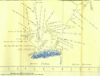
Between 1961 and 1963, Mikhail I. Belov, polar historian, published three important studies in which he analysed unsigned navigation charts of the Russian Antarctic expedition drawn during the voyage (Belov Reference Belov1961, Reference Belov1962, Reference Belov1963). According to him and his group of experts, the compilers of the maps were clearly officers of the expedition. These maps were probably drawn for the Emperor and the Minister of the Navy to illustrate the discoveries in the region of the South Pole (Tammiksaar Reference Tammiksaar2014: 293, footnote 15). On the basis of 15 navigation charts and of the colours used on them, Belov tried to prove that the verge of the continental ice Lazarev had seen on 28 January 1820 had been depicted on chart no. 2 (Belov Reference Belov1962: 111, Reference Belov1963: 32–33) (Fig. 7). Belov's arguments were partly acknowledged internationally (Jones Reference Jones1982; Fogg and Smith Reference Fogg and Smith1990: 28; Landis Reference Landis2001: 35; Trewby Reference Trewby2002: 39). But on the chart, a note on that day reads ‘solid stretch of ice was seen’, rather than ‘ice of extraordinary height’ as written by Lazarev. ‘Solid stretch of ice’ was that day seen from the ships by Bellingshausen (Reference Bellingshausen and Debenham1945: 117) as well as by Novosil'skij (Reference Novosil'skij1853: 29). Thus, the navigation chart confirms what was written by Bellingshausen and Novosil'skij, not the information in Lazarev's letter.
Bellingshausen's route to the south on 28 January 1820 according to the navigation chart. Contours of impenetrable ice (colored blue) stopped voyage further south (Belov Reference Belov1963, map No 2).

The question is why Bellingshausen had considered it necessary to indicate on the chart with own handwriting a ‘solid stretch of ice’? Aside from this note, six other important notes of Bellingshausen were on the charts, which denoted the sighting of the previous known de Traversay and South Sandwich islands, and the discovery of Peter I Island on 21 January and Alexander I Coast on 28 January 1821 as ‘saw the land’ (Belov Reference Belov1963: 110, navigation charts no. 1–15). The note on ‘solid stretch of ice’ extending south, however, marks the end of Bellingshausen's first important and, as later become clear, furthest attempt at approaching the South Pole during first season in 1820, since according to the instruction by de Traversay, he had to sail as far as possible to discover new lands (South Continent) (Tammiksaar and Kiik Reference Tammiksaar and Kiik2013: 186). The corresponding dark blue colour on the map denoted impenetrable ice, not ‘ice of extraordinary height and extensive like a coast of land’ (‘the verge of continental ice’). Later, the ‘solid stretch of ice’ or ‘ice of extraordinary height and extensive like a coast of land’ seen on 17 February blocked their way to the south. The contours of ice depicted in the navigation chart found in the Bellingshausen map (Reference Bellinsgauzen1831a) coinciding with the ice contours published in the uncoloured maps of Peter I Island and Alexander I Coast (respectively No 61) (Fig. 8). So there is no reason to doubt that the ice hand coloured dark blue in the navigation charts simply indicated the limit from which the ships could not move further, nothing else. This point of view of Bellingshausen is also confirmed by what Simonov had seen on 28 January 1820. Simonov wrote: ‘. . . at last we approached 69º30′S, where impenetrable eternal ice set limits to the power of man in moving on [to south]’ (Simonow Reference Simonow1824: 11). Thus it is not surprising that Bellingshausen, as a good cartographer, who had compiled maps of the first Russian voyage around the world 1803–1806, had omitted these navigation charts from his atlas and they were forgotten. He did not consider the sighting of stationary high ice coasts a discovery (terrestrial land was not seen), and the position of ice could be described in his narrative, as indeed it was. As concerns Soviet science, the discovery of these charts, actually contradicted the statement that Antarctica was discovered by the Russian expedition.
Map No 61 from the atlas of Bellingshausen (Reference Bellinsgauzen1831a), the route of the Russian Antarctic expedition near the coast of Alexander I Land on 29 January 1821. Contours of impenetrable ice attached to the coast are in black-white version (typical for that time maps and illustrations everywhere in the world) but in its style and structure identical with the navigation chart (compare Fig. 7).

Thus the navigation chart of the Russian Antarctic expedition proves the validity of the texts by Bellingshausen, not those by Lazarev. But how is it possible that these two dates, 28 January and 17 February 1820, which appeared to be so important from the point of view of later Antarctic exploration, were described completely differently by Lazarev and Bellingshausen. According to Belov, Lazarev had written his letter on the basis of the logbook (Belov Reference Belov1962: 111), but he does not provide any proof. It rather seems that Belov was (purposely?) mistaken in order that the letter would seem ‘more scientific’ beside the navigation charts. Thus, the only explanation is that Lazarev wrote the letter to his friend without consulting his personal maps from the voyage (if these existed!) and travel notes (which have not been found up to the present day). He probably made the simple human mistake of exchanging the dates 28 January and 17 February in his letter. This was not important at the time. According to some Russian authors, it was just Lazarev's letter that proved that he, not Bellingshausen, had discovered the Antarctic continent and had known the nature of continental ice in Antarctica (Trapeznikov Reference Trapeznikov2003: 128–139). But Lazarev, at the same time, resolutely disproved the existence of the Antarctic continent at the end of his letter (Pis'ma. . . 1918: 59; Bulkeley Reference Bulkeley2014: 171). Neither Lazarev nor other participants in the expedition placed much attention to the sight ‘ice of extraordinary height and extensive like a coast of land’ and associated it with certain land as can be concluded from the articles by Simonov, the diary of Novosil'skij and the writing by Bellingshausen. But there was one thing in his writing accepted by every member of the expedition; lands discovered within the Antarctic Circle in January 1821 were the southernmost as compared to those discovered up to that time and indicated to the possibility existing of other ‘mainlands’ in southern polar regions. This was an important result and was, perhaps, generally accepted.
Conclusion
According to de Traversay's instructions, the aim of the Russian Antarctic expedition (1819–1821) was to find the fabled south continent, the existence of which James Cook assumed but considered impossible to discover. As opposed to Cook, the Russian Antarctic expedition under the command of Bellingshausen and Lazarev discovered terrestrial land within the Antarctic Circle in January 1821. However, like Cook, they could not prove the presence of a continent. In this context, Bellingshausen and Ivan M. Simonov, who wrote about the Russian Antarctic expedition in detail, agreed that it was impossible to discover the continent if this existed there at all. The view that the Russian Antarctic expedition had not sighted the Antarctic continent dominated in Russia until the beginning of the twentieth century.
The expeditions launched by Great Britain, the United States, and France discovered several new patches of land in the region of the South Pole at the end of 1830s and beginning of 1840s. As a result, several scientists, cartographers, and navigators began to speak openly about the presence of a continent in the South Pole region, although the point of view that there was no continent was just as popular. Specific geographical conditions of the Antarctic continent, the hard-to-define icy coastline, difficulties in approaching it, and severe natural conditions prevented any clear answers until the first decade of the twentieth century. The few expeditions to the southern polar areas that provided some data of scientific importance in the nineteenth century were searching for land, rather than ice. Little, however, was discovered during these voyages. No expedition or explorer of the nineteenth century was able to solve the main problem of the southern polar areas, that is the existence of extensive and large icebergs, and the presence of ice shelves (continental ice) in this region. The peculiarity of Antarctica lies in the fact that it is not mainland, but a land of ice, totally different from terrestrial land. Of course there were at the end of the 18th century and the beginning of the 19th century speculative views in the style of Georges-Louis Leclerc de Buffon's ‘ice cap’ and his follower William Scoresby with his ‘continuous ice field’. They suggested on basis very few observation data, that both poles are covered with floating continuous ice sheet but real scientific argumentation that a continent can also be made up of ice is only feasible through the ice age theory, a perspective developed only in the end of nineteenth century.
In the 1840s, after the results of the Wilkes and J.C. Ross expeditions had been published, discussions about who discovered the Antarctic first arose. According to some American researchers, it was Wilkes; for the British, it was Ross; for the French, it was Jules Dumont d'Urville; and in Russia, some authors stressed that the discovery of Alexander I Coast could be regarded as the discovery of the entire Antarctic continent. As there were very few empirical data about the (non-)presence of the continent, these discussions could not be resolved and every one participating was independent in his/her conclusions, there was no pressure and no preappointed thoughts.
Interestingly, as a result of the ‘heroic age’ in the early 1900s, the existence of the continent in the South was proved theoretically as well as empirically, while the question of who discovered Antarctica was still open. As compared to the 19th century, the modern situation was totally different: attempts were made to establish who first sighted Antarctica, not how complicated it was for earlier generations to understand the nature of it. The first sight did not need any understanding, it was only important to make the world accept that.
Perhaps this development was result of the glorious celebration of the discovery of America in 1892 (Fleming Reference Fleming and Speake2003: 271). Christopher Columbus was the first to sight America in 1492 but this was unknown in European society until 1825 when Spanish sailor Martín Fernández de Navarrete rediscovered Columbus journals and published them (de Navarrete Reference de Navarrete1825). But still in 1850 in the British empire John Cabot was honoured as the discoverer of North America (compare Jones Reference Jones and Hakluyt1850: lxviii). In 1892 Columbus’ priority of honour was acknowledged. Now honour and priority became crucial during the ‘heroic age’. The attempts to conquer the North or the South Pole are the best examples in this context. It was not only competition between explorers, but also between different countries, because the national pride was at stake and that made it extremely significant. Thus, to be first was an important political instrument in proving one's supremacy in the world. The first sight of Antarctica and the title of its discoverer also belonged to that category. To receive this title made investigators go to archives. That is why the Americans and British were ready to replace the names of their glorious explorers Wilkes and J.C. Ross with those of the almost unknown Nathaniel Palmer, Edward Bransfield, William Smith and Charles Poynter, the co-traveller of the last-mentioned (Campbell Reference Campbell2000: 132). Russell Owen had a reason for writing in 1941: ‘The argument as to who (Palmer or Bransfield) saw it [Antarctic mainland] first has been for many years, particularly in the twentieth century, a matter of acrimonious debate between American and British scientists’ (Owen Reference Owen1941: 41).
As the Soviets had similar aims with the Americans and British, after World War II, they also entered the political debate upon the question of who first discovered Antarctica. That was an opportunity to show one's position in the days of the cold war. To reach that aim, texts by Cook, Krusenstern, Bellingshausen, and his travelling companions were altered to an extent that their content was in accordance with the interests of the Soviet authorities (Tammiksaar and Kiik Reference Tammiksaar and Kiik2013; Bulkeley Reference Bulkeley2014). Similarly as American and British scientists were concerned with Palmer and Bransfield, Soviet researchers relying on scientific investigations of the most recent period took little interest in how Bellingshausen and Lazarev had estimated their observation results. Partly under political pressure and partly on their own patriotic initiative, they considered it a priority to prove, by any means, that Bellingshausen and Lazarev knew the nature of the continental ice and discovered the Antarctic continent in January 1820, not in January 1821 when they first sighted terrestrial land within the Antarctic Circle.
It is regrettable that Bellingshausen, Bransfield, and Palmer were drawn into cold war agendas, and scientific integrity was almost forgotten. Bellingshausen, Lazarev, Ross, Wilkes, Dumont d'Urville and others did not know as much about Antarctica as we know today. Antarctica, (in this case) should be analysed with consideration to what was known about it at the time (for example ice theory, doubts about the existence of continents that are not terrestrial etc). This has been the main problem of the history of Antarctic exploration, given its complicated physical geography.
Proceeding from today's knowledge, we could consider any of Bellingshausen, Lazarev, Palmer, or Bransfield as discoverers of Antarctica, but we should not deliberately ascribe modern aspects of scientific knowledge to them or other Antarctic explorers. It would be more correct to accept that our knowledge of the complicated physical geography of southern polar areas has changed slowly but completely, and for that reason, it is not justified to point out the first pioneer of Antarctica. Another reason is that the question of who first sighted the mainland of the Antarctic continent has throughout the 20th century, depending on antagonistic relations of the countries and national pride, been, in the first place, a political, and only a long way after that, a scientific task. The political aspect has not been forgotten even today, for example, compare British and Russian encyclopedias. The Antarctic Treaty concluded in 1959 was a reasonable compromise in solving the claims to Antarctica in a neutral way. Such a neutral attitude should be used in solving the question of the discovery of Antarctica, too and there is no sense in trying to establish who discovered Antarctica first, since it is not within anyone's power to solve this problem.
Acknowledgements
This article was supported by Estonian Ministry of Education Grants No IUT 02–16, by Estonian University of Life Sciences 13005SPTL and from the Grant of European Union KESTA No 3.2.0801.12–0044. Many thanks to my good friends Natal'ya Sukhova, Cornelia Lüdecke, Stéphane Schmitt, Vello Paatsi and especially Rip Bulkeley for valuable comments and help with literature sources. For English revision of the text my thanks are due to Maie Roos and Marielle Dado. Also grateful thanks to Olga Stone for reviewing the Russian texts in this paper.