

INTRODUCTION
Archaeological sites and monuments, embedded and scattered along the countryside, peri-urban or urban spaces, have dominated Mediterranean cultural landscapes for thousands of years. Cultural landscapes in these regions have sustained intensive human activity for 10,000 years; it is difficult to find any place which epitomizes untouched nature in these regions.Footnote 1 Yet, with its rich biodiversity, the Mediterranean region of Turkey still encompasses unspoiled coastal regions with seascapes, lakes and wetlands, mountainous zones with various ecologies, endemic plants and wildlife, and, above all, many unexcavated archaeological sites.
In Turkey, conservation and presentation of archaeological sites and monuments began with the development of modern archaeology in the late nineteenth century. From that time on, archaeological techniques and subjects of conservation have been gradually changing and developing at archaeological sites. Famous ancient cities have been unearthed, and axes of ancient towns and important monuments have been identified, and in some cases impressively restored.Footnote 2 Nevertheless, institutional archaeological activities have mostly focused on architectural heritage conservation, with the landscape setting with its visual and ecological authenticity receiving little attention. However, archaeological sites are located in unique complex landscape settings composed of architectural remains, visually and spatially interrelated spaces, and ecologies with topographical features, framed by landforms. Their built environments are always connected to a particular urban or rural landscape with a spatial and visual dependence. AnagnostopoulosFootnote 3 states that the relationship between any true work of architecture and the environment in which it will be placed is not merely a matter of scenery; it is a complex and deeply organic relationship stemming from the overall visual, functional, and structural dependence of the building on its site, a dependence that is ecological in character.
Historic landscapes are one major element of cultural landscapes: They exhibit enormous variety, depth, and sensitivity; they are places where people live, work, or take part in recreational activities.Footnote 4 These landscapes, in their broadest and most useful sense, include aspects of historic features that are not archaeological; they include topographical formations, patterns of land use systems, settlements, fauna and flora, as well as sociocultural values, traditions, and identities. In this sense, the complexity of historic landscapes cannot be reduced to artifacts and the landscape is more than its historic elements.Footnote 5 Conversely, cultural and natural resources in cultural landscapes are faced with many developmental pressures caused by changes in land use such as agriculture, industrialization, urbanization, expanded areas of buildup areas, and mass tourism. Today, the cultural heritage of the countryside appears to be packed into urban peripheries, agricultural lands, new settlements, and tourist regions. Although cultural heritage is protected in a site-specific manner where the built items they contain are displayed, places of natural significance are preserved traditionally as nature zones and national parks on a regional scale. However, archaeological landscapes as a whole are virtually unprotected by designations. Demarcating visual boundaries, in turn, produces spatial and visual fragmentations in the physical environment of cultural landscapes where new developments in land use and tourism compete for space. This leads to the loss of material and immaterial information about the setting and its culture as well as to the loss of visual and spatial relationships between sites and landscapes. This recognition forces specialists including archaeologists, conservationists, planners, designers, and resource managers to rethink integrated approaches to natural and cultural heritage and land use developments on urban and rural scales. The result has been an evolving process that spurs new scientific know-how for preserving and using landscapes.Footnote 6
Landscapes should be considered in terms of forms, functions, processes, and context.Footnote 7 Salter refers to the forms in landscapes and defines cultural landscape as “that segment of earth space which lies between the viewer's eye and his/her horizon.”Footnote 8 It is essential to emphasize all forms and structures among the various components of landscapes to define the spatial and visual interfaces of the conserved heritage. Although site-specific heritage presentation contains forms and functions, archaeological landscapes possess context and processes which make them vivid and extremely intersighted. Therefore, the optimal approach unites the attributes of past and present in an integrative landscape conception, amalgamating historical, visual, and spatial features. To set the strategies for a coherent management plan, we should understand these changing spaces with their dynamic natures, defining their character within their environments. Focusing on these objectives, this article explores the visual qualities and place values of archaeological heritage with a tripartite conceptualization of landscape integrity, considering the archaeological landscape setting as artifact, architectonic space, and scenery. The cultural heritage complex of Bergama in Western Aegean Turkey is used as a case study.
VISUAL LANDSCAPE INTEGRITY
After two decades of focused investigations into the phenomenon of heritage, the field of heritage studies is firmly established in academics and now has a recognized and solid theoretical foundation,Footnote 9 as indicated by the broad spectrum of scholarly heritage research in historical, social, cultural, and architectural fields. However, heritage sites as a contemporary visual space assessed within their physical environments have remained underexplored. In particular, research into the visual aspects of heritage landscape and site presentation from a landscape approach is still lacking today.
From a landscape approach, heritage sites are considered within their wider landscape settings where they directly or indirectly interrelate and affect other cultural resources, ecologies, settlements, and people through visual attributes. Jakle refers to particular places that are intended to be picturesque.Footnote 10 This creates distinctness in a wider setting, which is the critical factor distinguishing heritage landscapes from single monuments, constructed parks, galleries, and museums, making them unique, vivid, and evocative. Regarding this point, Garden points out the problem of analyzing heritage sites without sites and the consequential effects of sameness and homogeneity.Footnote 11 When a sense of place evokes a feeling of homogeneity, where one seems to see “the same old stones in every archaeological site,” the place lacks its own quality of character and identity. Creating memorable physical settings to engender space quality is also often debated by landscape designers.
Tripartite conceptualization of visual landscape integrity including artifacts, three-dimensional space and scenery is a useful way of grasping the interplay and integration of landscape values in heritage landscapes. These three factors make up the main visual characteristics of a heritage site and allow for an integrating landscape approach. On one hand, this approach helps viewers (visitors, tourists, and laypeople) perceive the sense of place and comprehend the significance of the site, providing for a better visual and spatial orientation in the site. On the other hand, it makes it possible for researchers, planners, stakeholders, and site managers as well as locals and authorities interested in heritage sites to understand the character of the sites, values, potential, and possibilities for sustainable conservation. In this respect, it is essential to point out two aspects to comprehend the framework of this approach. First, a landscape approach compromises visual and tangible components of the landscapes, focusing on the physical and spatial interrelations of spaces linked with cultural heritage sites. Second, it provides a framework for spatial planning and can be applied to every heritage landscape where sufficient archaeological material exists which is accessible to the public.
In fact, landscape is subject to change, because of its highly evolutionary nature as well as the changes that human beings have forced and continue to force on it to create a livable world.Footnote 12 A place retains its meaning to the extent that people continue to expect certain satisfactions (or dissatisfactions) implicit in behaviors contained.Footnote 13 The sense of place from spatial, architectural, social, and psychological viewpoints has been researched by different authors.Footnote 14 Lynch writes: “Sense depends on spatial form and quality, but also on the culture, temperament, status, experience, and current purpose of the observer.”Footnote 15 Lambrick argues that perceived importance can be closely related to the quantity and quality of detailed information, but is above all connected to its current appearance; in fact, it is more connected to the perceived environment than to its authentic character.Footnote 16
Today, apart from the scientific and didactic values of archaeological sites, public use and recreation (in other words, access and tourism) dominate Aegean archaeological sites. The activity of archaeological site visitation has created an ancillary tourism sector, which tends to appear as an obligatory component of holiday packages. Visitors are fascinated by ensembles from ancient times that are visible, touchable, and legible.Footnote 17 To create an authentic staging for visitors, it is necessary to identify the scenic and archaeological values, define the boundaries of the space, and emphasize the selected characteristics. To improve the quality of the visitor experience, however, minor urban design interventions that accentuate the physical landscape setting are necessary. Such beneficial settings can offer choices of routes, offer diversity of experience, and encourage exploration. This increases modes of mobility and can contribute to engaging the interest and attention of the visitors.Footnote 18 Above all, it can achieve sustainable conservation of archaeological sites and landscapes as an essential part of archaeological resource management. The planning objectives encompass a wide range of aspects including landscaping, preservation, nature protection, local prosperity, and land use.
ARCHAEOLOGICAL LANDSCAPES AS ARTIFACT
Considering the landscapes as artifacts points to the physical aging of heritage sites, which display historically and archeologically significant tangible and intangible features modified by human action. It refers to both constant (past) features that have been conserved as well as changing (contemporary) values that are perfectly integrated into the landscapes. On one level, the concept of artifact signifies the substantial and historical values of the heritage landscape that should be preserved. On another level, it refers to the esteemed values of heritage appreciated as objects of art. This concept helps us grasp how heritage sites work and what they do over time (the evolution process), to understand how both heritage and heritage sites change and grow over time.Footnote 19 Archaeological sites combine different concepts and elements beneath their aged and weathered surface. They are made, reshaped, or modified by human culture and historical circumstances; each one adapts itself to its local physical setting. In this sense, it is clear that earlier communities also had their own perception of landscapes that occupied the same space as the landscapes of today.
Landscapes provide essential information about all vestiges of human existence. Archaeological remains of cities, ancient quarries, burial mounds, and routes as well as human-induced topographical formations such as river basins and vegetation formations including maquis, forests, and olive groves are all indicators of the evolutionary character of the landscape. In nature particular natural forms are found that have inspired human creation since the beginning of time and have thus become the loci of meanings projected by the human mind.Footnote 20 Landscapes have been reorganized either consciously or subconsciously for a variety of religious, economic, social, political, environmental, or symbolic purposes. Landscape elements such as mountains, rocks, springs, rivers, and lakes were assumed to be sacred in the ancient Hellenistic and Roman cultures. They were associated with particular divinities and allowed the population to come into contact with the supernatural.Footnote 21 Some features have hardly changed over the centuries. Many still dominate the Mediterranean terrain where monuments make explicit reference to features in the wider landscape. They possess material and immaterial information about the past and present, which interweave in real, perceived, and symbolic ways.Footnote 22 How landscapes are perceived and interpreted has defined the structure of landscapes and changed land use patterns.Footnote 23
Integrated heritage conservation is strongly linked to the artifact concept. Here, conservation is aimed at raising the interest in sustainable cultural landscape preservation, reducing the developmental pressures on heritage sites and landscapes. This should refer to past and present aspects. Additionally, this is aimed at underscoring the historical and natural values and enhancing the authenticity of the space within its landscape that makes it attractive and interesting for visitors.
ARCHAEOLOGICAL LANDSCAPES AS THREE-DIMENSIONAL SPACE
Three-dimensional space refers to the spatial distribution of objects (sites) and locational qualities. Higuchi calls this depth, which is an effect of a continuous change in the surface and of atmospheric perspective or the overlapping of objects viewed.Footnote 24 This is created with the help of a continuous background, which assists in defining boundaries and enclosures in a space. In a visual sequence, space generates modes of movements. There are different ways in which these forms take shape in landscapes. Principally, architectonic forms occur, mostly as human creation, throughout the evolution of places and landscapes over time. Because of the complexity of the landscapes and the nature of the archaeological remains, some of these forms can be better perceived than viewed in the wider setting. The so-called landscape roomFootnote 25 is a perceptual unit bounded by a floor, walls, and a ceiling. This constitutes the interior space of the site. In the wider landscape, it appears where topographical features such as mountains and rocks, vegetation, and sky frame the heritage site, providing a monumental backdrop. The local settlements, their vernacular architecture, traditional land use and contemporary sociocultural aspects shape the image of the space. Additionally, a heritage site is a complex social space constructed by the interaction and perceptions of individuals who visit the site.Footnote 26 Without a sociocultural framework, space has no qualities of its own; the interaction between nature and culture reveals the cognitive, material, and functional aspects.Footnote 27
Spatially, integral spaces constitute exterior and interior divisions. In considering the architectonic space, two types of ordering systems can be identified: One is characterized by the horizontal and another by vertical forms in the landscape. This shapes our perception of depth in space. Spatial separations such as barriers or boundaries between these divisions can vary in form, and the structure of the material determines the character of the space. It could be a wall, a gate, a monument, or even a hedge or groups of trees. The visual definitions can be intensified by differentiating interior from exterior spaces or by delineating rooms with a structure though the use of materials different from those found on the site.Footnote 28 Ideally, exterior space should be consonant with interior space to provide fluxes, spatial and structural sequences among the spaces in heritage landscapes. This creates space experience and generates amazement. Barriers and shelters for protection, planned routes for visitation of the site, and design of infrastructural units such as parking lots, entrances/exits, visitor information centers, and refreshment utilities enhance the place quality, help orient the visitor, and imply the connections between components of the heritage landscape. In a broader sense, organizing appropriate space for visitation in a visual sequence allows people to move freely in archaeological sites.
ARCHAEOLOGICAL LANDSCAPES AS SCENERY
The concept of scenery simply refers to the visible form and quality, and the dualistic relationship between the physical state of a heritage site and the viewer's perception. A view is a powerful stimulus; it comforts and inspires. Views generate emotions, and expand the spectrum of imagination with their aesthetic values. Views and panoramas contribute immeasurably to the character of the site where the viewer stands and, in turn, bestow those same characteristics on the viewer. In a similar manner, views represent all that the place and landscapes represents. Landscape consists of visible and perceived environments constructed both materially and perceptually.Footnote 29 Tuan writes that landscape is an image, a construct of the mind and feeling.Footnote 30 It is critical to address the physical landscape in its visual fashion to achieve adequate and in-depth coverage of its complexity. The visual contact of heritage monuments within their landscape setting is of essence; it enables the viewer to grasp, perceive and interact with the tangible and intangible values. Even if inaccessible, historic landscape features may constitute a very valuable visual amenity in the wider landscape or for the setting of historic buildings. Initial eye contact begins at the entrance of the site. Jakle describes it as a sense of announcement that makes it exciting.Footnote 31 Sometimes, a view comes into sight unexpectedly in the panorama exposed.
Heritage sites have strong visual identities as a whole variety of present and past visions are encapsulated in the physical place. They are reflected as panoramic views, landmarks, viewpoints, and visual units. Archaeological sites within their landscapes present contradictory readings, including ideas of permanence and decay, domination and resistance, stability, and mobility. Additionally, the areas of visibility are connected to the topographical features and distances between viewer and object.
The term “visual envelope”Footnote 32 refers to a complex web of visibility that encloses the area of a site within its landscape. Significant views enter the psyche of a place to be remembered long after other details are forgotten. In a way, views represent all that the place itself represents. Archaeological sites are also mostly perceived in relation to their scenic qualities. In this sense, contemporary views of archaeological sites within their landscapes are strictly connected to the presentation of the heritage, which is in fact a delicate issue. The picturesque quality of the landscape and its aesthetic values obtain a subjective approach that is mostly dependent on current aesthetic values.Footnote 33 They constitute a unity with rich visual qualities, despite the selective power of the eye. Visual continuity during perception can be broken by visual barriers such as cultural elements, topographical features, and plant cover. Every archaeological ensemble has a unique shape, color, or arrangement that facilitates making vividly identified, powerfully structured, highly useful images of the environment. Hence they uphold a constantly evolving and complex unity of perceptions.Footnote 34 Higuchi focuses on the visual elements of landscape that grasp the nature of the setting as a visible spectacle and spatial structure.Footnote 35
THE CASE STUDY: THE CULTURAL HERITAGE COMPLEX OF BERGAMA
The cultural heritage complex of Bergama is located in the northwest of the Aegean region of Turkey where the Madra Mountains in the north and the Yunt Mountains in the south expand into the Bak̅rçay Plain (Figure 1). The town of Bergama, located 110 km north of İzmir and 30 km from the coast, has a population of 60,000 that increases to 120,000 when including the surrounding districts. It lies in an area surrounded by agricultural land with pine forests on the high Kozak Yaylas̅ (plateau) and the Pergamon archaeological site to the northeast.
The location of the town of Bergama.

The region has a richly diverse natural and cultural resource record created through the long-term interaction between humans and their landscape on urban and rural scales.Footnote 36 Bergama and its environs epitomize unique living cultural-archaeological landscapes shaped by constant human intervention. For thousands of years, these landscapes have been used and reshaped for their resources and appreciated for hallowed and picturesque values in their changing forms. Today cultural heritage, as remnants of these past cultures, affects the image and function of the region in the dynamic tourism industry.
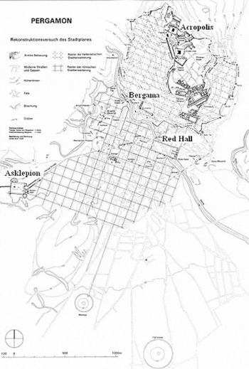
Visible archaeological sites and monuments of Bergama's cultural heritage complex are scattered around different locations in the town (Figure 2).Footnote 37 The archaeological site of Pergamon with the Acropolis and the steep Hellenistic theatre, landmarks of the modern urban landscape of Bergama, loom over the city; the Roman Temple, the so-called Red Hall named after the red brick building material, formerly located in the lower part of ancient Pergamon, is today found in a congested urban district of Bergama. The Sanctuary of Asklepion is situated in the southwest part of town, adjacent to the military zone.
The town of Bergama and the archaeological sites of the Pergamon, Acropolis and Asklepion.

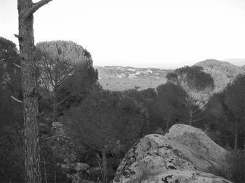
The ancient thermal spa settlement of Allianoi is situated approximately 20 km to the northeast of Bergama, surrounded by forest, agricultural land, and the soon-to-be activated water reservoir of Yortanl̅ Dam. Additionally, according to recent research done around the Pergamon, the existence of other ancient settlements related to the Pergamon including Perperene, Atarneus, and Elaia (the harbor city of Pergamon) has been identified.Footnote 38 What makes these cultural landscapes remarkable is the spatial and visual interrelations between nature and culture. Apart from rich ancient remains dispersed throughout the rural and urban landscapes, the region is famous for its thermal water springs, gold quarries, and the biggest pine nut forest (Pinus pinea) in the Aegean region, which has been exploited for its edible pine nuts since ancient times. (Figure 3).
Pine nut forest Pinus pinea in the surroundings of Bergama.

When we speak of living cultural landscapes, we can think of Bergama and its environs, with their natural and cultural resources as the outcome of constant human interaction in all parts of different landscape settings. Uses of land as well as cultural and natural resources have been part of this culture for thousands of years. Treatment in thermal water springs has been a long-standing tradition in Western Anatolian cultures. Water springs of three well-known ancient healing complexes—the Sanctuaries of Asklepion, the spa settlement of Allianoi, and the so-called Cleopatra's Thermal Bath—can still be visited and partially used today. Every year, the ancient Theatre of Asklepion hosts thousands of people in for festivals and concerts. In Basilica, in the so-called Red Hall, annual religious ceremonies including pilgrimages take place. How are these sites perceived in the landscape and what are the visual aspects that make these particular places interesting? How can recreation and visual amenity be supported by underpinning the key elements of the region? With the help of a tripartite conceptualization of visual landscape integrity, values and characteristics of the sites can be identified to propose an integrated management plan.
URBAN LANDSCAPE OF BERGAMA AND THE ANCIENT CITY OF PERGAMON
Historically, the area occupied by the ancient city has been significant. The famous city of Pergamon was founded on the hills of Kale Mountain in 281 bc and became the capital city of the Attalid Kingdom in the Hellenistic era. In the Roman period, under the rule of Trajan and Hadrian (the first half of the second century ad), with the removal of fortifications, Pergamon stretched down to the lower level of the Bak̅rçay Plain, where the town of Bergama is located today.Footnote 39 It became one of the most important cities of Roman Empire in Asia Minor. Various ancient monuments and remains, embedded in the urban landscape, have been traced back to this period.
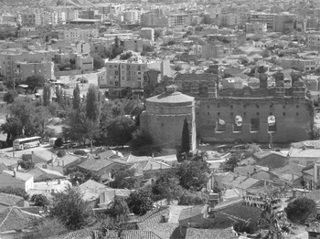
Today, the Acropolis is visible from every point in the town. At the main square, the impression of depth that the archaeological landscape evokes is even stronger. Nevertheless, because of uncontrolled urbanization and inadequate preservation strategies, they face pressures on different levels. The ruins of the theater in the lower part of Pergamon has been threatened for years by outskirt areas that have been built up overnight without proper permission, whereas the Roman Stadium has already been partly demolished to build residential districts. The Red Hall lies in between a commercial district congested with buildings and a bus and car parking lot on one side and old Ottoman district on the other (Figure 4). Thus there is a rich legacy of natural and built heritage in urban Bergama, but unfortunately only the latter receives any institutional and municipal protection. Apart from the archaeological heritage, old districts with vernacular houses, mosques, and other buildings from the Ottoman Period that could have been overwhelmed by decay and demolition contribute to the visual historical features of Bergama.
The Red Hall between modern buildings in the background and old Ottoman houses in the foreground.

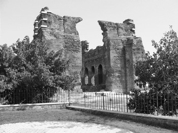
The Red Hall is located between a congested modern area and the old Ottoman town. Although the three-dimensional space of the temple site has a strong visual depth with the Acropolis in the background, it has been isolated and fenced off rather than integrated as part of the larger urban landscape (Figure 5). The exterior spaces of the site did not contribute to a qualitative and harmonious visibility. Tourists who visit the site perceive the remains, but at the same time conceptualize the location visually in its wider landscape. In this respect, exterior spaces are also interrelated within the site; they create the three-dimensional space whose presence attracts visitors. They should therefore be displayed in the context of the urban setting.
The Red Hall.

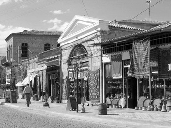
Recently, these spaces were renewed and enhanced in an integrated streetscape; commercially used historical buildings along the site were restored; pavements and streets were paved with brick and granite, underlining the archaeological site and historical urban landscape (Figure 6). Additionally, by paving, illuminating, and planting trees and bushes to frame the Red Hall, the entrance of the site was laid out as a park with places to sit and rest. The temple building attracts the eye, whereas the streetscape directs and contains the view. To integrate an urban heritage context, a visual tie should be developed for the visitor to experience while moving in search of scenery. This can engender a strong feeling of visual continuity and depth in the historical urban texture.
Shops in front of the Red Hall.

In the urban context of Bergama, it would be possible to create urban tourism in which visitors could saunter along the streets, combining the images of open spaces with heritage sites, squares, and parks. An alternative path providing full engagement with the past and present spaces, passing along the heritage settings, commercial streets and bazaars, the Red Hall, and the old Ottoman district, could ultimately lead to the Acropolis. Traffic could be regulated by declaring the heritage districts a pedestrian zone with limited vehicular access; in particular, the bus and car parking lot should be moved to another area. Through the streets of the old town, the beautiful façades of the houses could be observed in a visual sequence. While walking through the streets, the panoramic sight of the modern town could be viewed in its wider landscape.
In the existing parking lot adjacent to the Red Hall, an information center could be of use to gather and welcome visitors and to introduce historical and archaeological information about the cultural heritage complex by means of media, three-dimensional models, books, and photos. Additionally, one spot of the park could be displayed in the form of an ancient herb garden, with didactic and recreational facilities which would reinforce interest in and perceptions of likely past landscapes. The information center could be the starting point for the individual or groups of visitors, offering guided tours and shuttle bus services. Here, visitors could obtain entrance tickets and brochures; finally, they could be directed to the cultural heritage complex including the museum. Such a place could generate new potential for the economic and cultural well-being of locals—including public awareness, engagement, and place identity—and the conservation of urban heritage and enhancement of the development of the town.
THE ACROPOLIS OF PERGAMON
The landmark of the town and region, the Acropolis of Pergamon with the Trajan Temple, which ascends the Kale (Castle) Mountain, punctuates the skyline of Bergama (Figure 7). The perception of the Acropolis begins far away when one enters the town of Bergama. This generates a powerful sense of announcement and physical identity. The remains of the ancient city of Pergamon are preserved as an acropolis cityFootnote 40 above the modern city. Therefore, its artifact character was protected from being demolished by any modern urban developments. Settled in the seventh century bc, structures on the Acropolis lie in an area enclosed by two fortification walls.Footnote 41 The architectonic topography of the site provides a visual and spatial enclosure and background for the urban landscape of Bergama. Today, it is still possible to observe how the steep slopes of Pergamon were shaped and integrated into the urban landscape. This landscape is best experienced while ascending the summit of the Acropolis by circumambulating the old streets of Bergama. Topographical and archaeological features interwoven in an outsized space constitute the texture of this cultural landscape. Entering the interior spaces of the site, the vast archaeological area creates a strong sense of open space and seeing into the past.
The Theater and Trajan Temple at the Acropolis.

The path from the entrance with a ticket booth directs visitors to the stairs which are followed by the open spaces where the areas of visibility are laden with reconstructed monuments including the Trajan Temple, theater, vista terraces, and information boards. This gives visitors a clear account of the most important elements in this archaeological landscape. Above all, there is a precise sculptural relationship which creates exact visual control and great spatial effects. The famous Pergamon Altar, whose remains are displayed in Berlin, was also located in the Acropolis, on the terrace between the upper Agora and the Temple of Athena. Although one can hardly sense the spatial boundaries of the Pergamon Altar, it is possible to perceive the visual architectonic space within its landscape and comprehend the holy character of this place. Here, this sense of three-dimensional space could be emphasized by arranging the space by planting sacred trees in a symbolic way, reviving the temple's form and significance. From a physical point here or behind the area of the restored monuments, other visible remains are sparsely dotted among the vast archaeological space, causing the architectonic space to blur. It is common for large spaces of archaeological sites to lead to problems for visitors perceiving the whole site; the visual limits are difficult to discern. Here, the sense of place should be stressed by encouraging visitors to wander around the whole archaeological landscape on designed paths, keeping the visual sequence of the wider setting in movement. Because these are the areas of less visitation, an alternative for tourists might be an attractive path that passes through natural and cultural settings, allowing panoramic views of the hill and modern town. The entrance of the alternative path would be located at the end of the old town district where the boundaries of the archaeological site begin. Along this path, shady sitting facilities could be provided where visitors would have the opportunity to perceive the archaeological three-dimensional space in its wider landscape. The archaeological space would then be in constant flux as one moves along the route. This would create a cohesive sense of place and layout.
THE SANCTUARY OF ASKLEPION
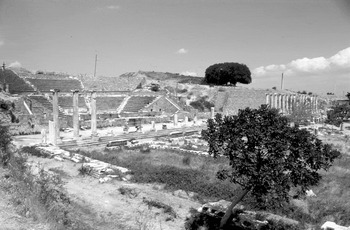
Asklepieion served as an important healing and pilgrimage center for worshiping Asclepius, the God of healing in ancient times (Figure 8). Located on a low rock, the Asklepion was initially surrounded by three water springs. Water and mud were two important natural elements for medical treatment processes. A temple, cult and healing rooms, houses and sleeping quarters, library, fountains, pools, and a theater were built. In contrast to the archaeological site of the Acropolis where the remains are outstretched in the inclined archaeological area, the architectonic space in Asklepion lies on a flat area enclosed by various remains and monuments which form smaller interior spaces. This creates a cozy and familiar sense of place offering inner tranquility and security. From the first instant, the visitor is captivated by the high visibility of ancient components in this enclosed space, which prevents the depth of exterior spaces from being perceived. Here, the sense of place is legible; the high visibility of the remains stresses their artifact character. The three-dimensional space is composed of visible boundaries made from pavement, walls, and columns and is extremely coherent and well perceived. This helps provide easy access and orientation on site. Because the most effective vantage points are elevated locations, the theater offers a clear sense of vertical dimension. From this perspective, the eye captures a diversity of objects. This site conveys a strong sense of past place through the visible remains as well as through its mythical and historical aspects as an ancient healing center. However, a visual sequence should be provided by a marked and signed path that runs throughout the site. In ancient times Asklepion was connected by a partly colonnaded sacred street, Via Tecta, to the center of Pergamon.Footnote 42 The significance of this spatial connection with Pergamon's urban context could be stressed by three-dimensional information boards. The ancient connection of the Asklepion with Pergamon via the modern town of Bergama through the sacred street could be partly reconstructed as another focal panoramic route that would imply visual landscape integrity between past and modern spaces. In this case, vegetation, especially trees and shrubs, could be used to mark the boundaries of the sacred street, framing the view in the rural landscape.
The archaeological site of Asklepion.

THE ARCHAEOLOGICAL SITE OF ALLIANOI
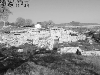
Located 18 km to the northeast of Bergama, on the road to the town of İvrindi, the archaeological site of Allianoi was established during the Hellenistic Age and reached its peak during the reign of Roman emperor Hadrian. Allianoi was famed for its thermal spring center and was known as the most important healing complex during Hadrian's rule (ad 117–138). The visible remains on site, which date back to the Roman period, the second century ad (Figure 9), are preserved in extraordinary condition. The site is located just inside the reservoir of the Yortanl̅ Dam, the construction of which was recently completed. The dam has not yet been activated because of the ongoing discussion in Turkey of preserving Allianoi, which would be in danger of being submerged and lost forever to the waters of the Yortanl̅ Dam. The thermal baths and the Nympheum remained in use for a long time, with some alterations.Footnote 43 Although the excavations in the archaeological site do not have a long history and the site has been partly opened for the public, the outstanding beauty of the natural environment and cultural resources has begun to attract many visitors.
The archaeological site of Allianoi.

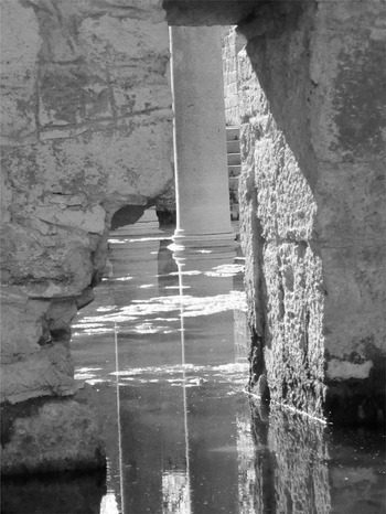
The archaeological site of Allianoi lies in an alluvial land enclosed by agricultural land and woodlands to the west. The site is separated into two parts by the İlya stream; in the north is the thermal spa center with thermal spring water baths in the therapeutic range of 45°C to 55°C, and to the south of the stream the remains of the civil settlement are located. Two sides were connected by a Roman bridge, which was used continuously until 1992, when it was demolished because of disinterest by authorities and experts. This site differs from the other archaeological sites in the region in which the natural resources—streams, woodlands, agricultural areas, hot water springs, and rich vegetation—enclose the archaeological sites and shape their landscapes. Here, the nature–culture interplay is evident. In Allianoi, the visual landscape changes constantly because of ongoing excavations if the site is not submerged under water. Yet, the openness of the space on the plain gives the impression of a coherent landscape where the visibility of the space creates panoramas which sweep to far-away horizons across one's field of vision. This site has great potential for a vivid and tangible public presentation combining thermal water baths, natural beauty, and cultural heritage to create visual amenity and recreation (Figure 10). The visual harmonization of existing remains engenders a strong feeling of continuity and place identity.
Allianoi.

Jameson writes that for an effective interpretation we need to reach out to our communication partners, in this case locals and authorities, and arm them with knowledge and understanding of how cultural heritage can contribute to people's sense of identity and ultimately improve their lives.Footnote 44 Hence, deliberate research and sensitive design measures should be required in laying out conservation concepts to prevent the complete extinction of its context.
CONCLUSION
Today, the visible elements of landscapes are becoming more important as visual attractiveness and recreation play a distinct role in shaping cultural landscapes. Tourism and leisure activities in historic landscapes are gaining ground as they influence and benefit the appearance of historical elements, making them remarkable and visible in landscapes. Archaeological sites produce strong visual qualities and create spatial qualities resulting from topographical variations. These landscapes reflect different impressions of the past on the multidimensional spaces of cultural and natural resources. This lends distinctiveness, meaning, and quality to the archaeological landscapes people visit or live in, providing a sense of continuity and a source of identity.
Generally, archaeological heritage contributes to the everyday lives of local communities on urban and rural scales, improving the quality of life. In Turkey, archaeological site visitation appears to be an ancillary tourist attraction to the sea-sand-sun factor in coastal tourism. However, ongoing developments in coastal regions compromise the qualities of the natural and cultural heritage to a great extent. This makes preservation and development rather complicated for heritage sites when they are subject to rapid change caused by urban pressure or agricultural demands. The outstanding characters of these places must be incorporated into people's lives in a creative fashion with sophisticated physical planning. Inhabitants and tourists need pleasant and integrated environments with distinct characters to engage optimally with their surroundings. Integrated planning should enhance the visual quality of the sites and their landscapes, underlining the important merits of cultural and natural components. This could be achieved if, on the one hand, the conservation of archaeological landscapes could be incorporated into a larger context, both in the field of archaeological preservation and natural resource conservation where archaeological sites are recognized as components of their larger landscape context. Additionally, fragmentations of landscape patterns and serious conflicts with natural interests would have to be avoided. On the other hand, archaeological sites could be identified as places with distinct spatial and visual assets on the landscape level, in addition to the material value that should also be strictly conserved. Garden refers to the opportunity of locating sites in the context of their larger environment and draws attention to the importance of the setting.Footnote 45 This could also emphasize the importance of the present layout of the site. By means of the visual landscape integrity approach outlined earlier, the interplay and integration of different landscape values can be brought to light, exposing new potential for heritage presentation. This could also help create new perspectives in terms of conservation and resource use for the process of sustainable management. Creative land use planning and site interpretation can increase public awareness of heritage protection on a socially, economically, and culturally sustainable basis. Unfortunately, the integration of visual considerations in the process of landscape planning and development has hardly been investigated because of a deficiency in the theoretical basis, academic involvement, and collaboration in spatial planning and heritage conservation within local communal planning systems. Nevertheless, when an efficient spatial organization that harmonizes with the visual relationship and structural fabric of cultural elements and natural resources is established in a heritage setting, the heritage and landscape is protected against the effects of development such as uncontrolled use and unplanned actions.
In conclusion, the challenge is developing a more forward-looking viewpoint and holistic approach to handling the heritage sites in their present landscapes. Every planning and management decision should be based on an understanding of its wider landscape, which will likely affect the significance of the visual values and should aim at creating distinct and visible spaces with locational qualities.