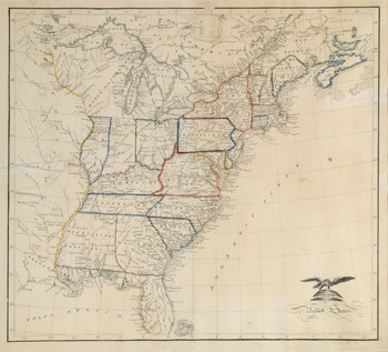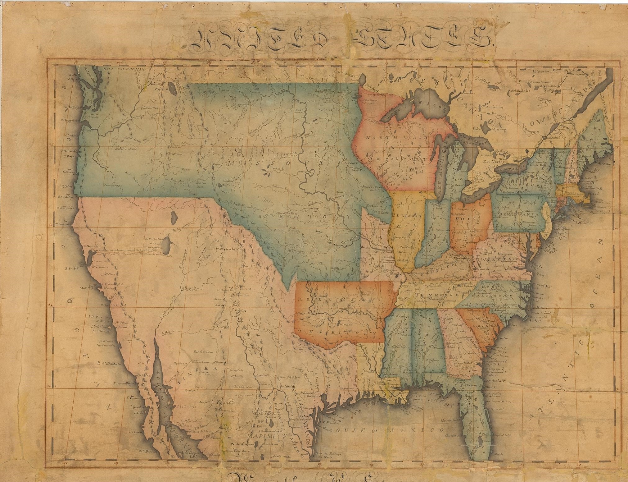


In June of 1816, sixteen-year-old Caroline Chester was one of 137 students enrolled at the Litchfield Female Academy (LFA) in Connecticut, the most reputable school for girls in the country.Footnote 1 Chester faithfully recorded her school experience in her diary, including a decision to make an elaborate map of the nation as part of her studies. She was inspired to undertake the project by a classmate who—by completing large maps of Asia and the United States—demonstrated “how much persevering industry joined with a large share of Patience will accomplish.” Chester worked diligently on her map throughout the summer term, devoting hours at a time on a project that she never expected to be so tedious. By late August, her frustration was palpable: “I once heard a gentleman remark that he had seen patience advertised for sale and if ever I have the pleasure of seeing him again I will petition him to purchase me a large quantity for I know no person who stands so much in need of it as myself.” A few days later, she was more straightforward: “I am quite tired of drawing on my map.” Chester's exasperation is explained by a glance at her map, virtually a copy of the published original issued during the War of 1812 (see Figure 1). She had meticulously replicated the entire printed map, including the form and content of the cartouche, the detailed borders and topographical features, and even the narrative annotations about native tribes in the far west.Footnote 2
Caroline Chester, “A Map of the United States,” 1816, 52 × 63.5 cm. Litchfield Female Academy. Caroline Chester's diligent effort to reproduce a national map was part of a popular school exercise to teach young girls several different skills. (Map courtesy of the Litchfield Historical Society, Litchfield, CT.)

By drawing a map, Chester was taking part in a school exercise that stretched across the country in the early republic. From the 1790s to the 1830s, students aged twelve to sixteen—primarily but not exclusively female—drew, painted, and stitched elaborate and enduring maps as part of their education in academies, seminaries, and other independent schools. Some maps were copied and traced, while others were freehand efforts guided largely by the grid of longitude and latitude. Some were assigned to serve the geography curriculum, while others were intended to showcase penmanship, artistry, and the cultivation of self-discipline. Most were a combination, made over the course of a school term, to demonstrate artistic accomplishment and geographic knowledge. They range widely in size, with some large enough to be displayed on rollers, while others were but a page in a school journal, or even smaller. Most of the examples that survive today—in archives, in map collections, and in the map trade—have been preserved for their precise execution and artistic achievement, with finely executed borders, detailed river systems, and extravagant ornamentation. Yet others bear marks of artistic freedom, or perhaps the lapsing attention of a distracted student. Several are unfinished, which itself helps us to see the process by which students engaged in these projects. Yet even these unfinished and rudimentary examples involved hours of effort.Footnote 3
From South Carolina to Maine, Maryland to Mississippi, the practice of map drawing constitutes a significant and unexplored phase in the history of education—particularly for girls—and a window onto schooling and pedagogy in the early republic. These teaching and learning practices spread quickly through female academies, often by teachers who had themselves been educated in this tradition. In the absence of published textbooks, coordinated and mandated curricula, or state-sponsored reform, map drawing became a time-consuming, demanding, and yet common exercise by the 1810s. By the 1820s, this tradition was so entrenched that educators began to question the relevance of long hours spent diligently drawing and copying maps. And in challenging this practice, they reflected on the pedagogy of geography and maps. Some characterized map drawing as part of an “accomplishment”-driven education that confined women to using maps as artistic objects rather than as tools of discovery. Others questioned the wisdom of exposing students to national and world maps without first teaching them how maps represent space and location. All of these critics were inspired by Johann Pestalozzi, whose attention to direct observation, “home” geography, and the gradual expansion of the student's horizon captured the imagination of so many educators in the mid-nineteenth century.
The widespread practice of drawing and copying maps also illuminates the career of Emma Willard, one of the century's most influential and prolific educators. Willard was herself a product of this education, and it shaped her understanding of pedagogy. We generally remember her as a pathbreaking female educator, but just as relevant is the degree to which her ideas, experiments, and pedagogy grew from an intensely visual school culture. From the earliest days as a headmistress in Vermont, her approach to teaching was influenced by her own education in the Connecticut River Valley. For the rest of her life, she advanced an intensely graphic approach to education, one that may have rejected mimesis but which replaced it with an equally nonverbal and memory-driven emphasis upon history and geography. More generally, the proliferation of map drawing in the early republic demonstrates the rapid adoption of a pedagogical tool that young women could use in their own teaching.
These school maps also constitute a fresh type of evidence for the history of education that details the learning experience of the early nineteenth century. In this respect, the maps enable us to move past national committee reports or idealized articulations of curricula to examine materials that were produced by students in an era long before the standardization of schooling. A study of children's mapping and the responses it prompted suggest that these elaborate assignments—spread through informal networks—directly shaped pedagogies and texts.Footnote 4 Finally, the practice of map drawing is an opportunity to examine the first generations of girls to receive higher-level schooling in America. Whether stitching a map of Boston Harbor in 1800 or painting a double-hemispheric map of the world in 1825, generations of young girls—and more than a few boys—turned toward the language of cartography to learn history, geography, penmanship, and place. In the process, the map became an instrument of literacy itself.
Female Education in the Early Republic
Historians identify the early national and antebellum eras as a watershed in female education, when the tradition of home schooling gave way to an awareness of education as a social experience. Hundreds of female academies were launched after the Revolution, but without state support these schools remained fragile, with some lasting only a few years in homes rather than in institutional settings. Regardless of size, all academies depended upon enrollment, and though state support was rare, the sheer number of these schools indicates a widespread demand for female education. In the 1810s, nine schools were founded in the Hartford area alone, six of which were exclusively for girls. Nationally, 182 female academies and at least fourteen seminaries were established between 1790 and 1830. The best known of these were Sarah Pierce's LFA, founded in 1792; Susanna Rowson's Academy, founded in 1797 in Boston; and the Elizabeth Female Academy, established in Mississippi in 1818. By the 1820s, academies were joined by female seminaries, an attempt to increase the sophistication of the curriculum and mimic the offerings of male colleges.Footnote 5
Although they grew quickly, peaking in influence before the Civil War, these schools were never as stable as their male counterparts, and this condition motivated Willard to establish a school for women in New York that would have the attention of not only local patrons but the state legislature. In the era before state support, the most successful schools were those that cultivated a solid curriculum, reliable instruction, and a reputation for moral integrity. The fragility of these schools might also explain why they offered a relatively homogeneous curriculum, for most fledgling schools took their cues from more established institutions. The LFA was one such model, its influence amplified by the number of its students who later became teachers. This curriculum—devised by Sarah Pierce in the 1790s—included a basic course of study that included “Writing, History, Geography, Grammar, Arithmetic, Rhetoric, and Composition, with plain Needlework.”Footnote 6
School notices confirm that geography was invariably among the earliest subjects taught in female schools, alongside grammar, composition, and arithmetic. It was broadly regarded as a source of self-improvement, civic engagement, and utility, but especially as an appropriate science for girls. Gloria Seaman Allen noticed geography in advertisements for female schools as early as 1786 in Maryland, with an impulse to “make maps” apparent in American schools and seminaries by the 1790s. After 1800, the LFA curriculum became a model to follow. Willard opened a boarding school in her Middlebury home in 1814, advertising “Reading, Writing, Arithmatic [sic], English Grammar, Geography, Drawing, Painting, and Embroidery.”Footnote 7 Geography persisted for years as a foundational study in the Shocco Female Academy of North Carolina. In Fayetteville, Arkansas, children of elite Cherokee Indians were educated in geography by 1839. Throughout the early republic, geography was as essential to literacy and citizenship as Noah Webster's spellers, and especially relevant as a way to expose students to regions of a country that most would never see firsthand.Footnote 8
In 1814, Pierce's nephew John Brace arrived at LFA to formalize the curriculum and elevate its rigor. Addressing the students in 1819, Brace emphasized the centrality of geography and history, for “without them, our minds would be narrowed down to the little spot in which we live and confined within the small prison of the present, & could never, as they now do, roam the universe at large, without effort & without pain. I know no greater proof of a weak mind, than an ignorance of these branches of education.”Footnote 9 Similarly, John Pinkerton prefaced his 1818 atlas by celebrating geography as “a study so universally instructive and pleasing, that it has, for nearly a century, been taught even to females.”Footnote 10 Both geography and map reading were used to cultivate literacy and prepare women for a life of usefulness as well as social exchange.Footnote 11 Yet while many have argued that separate institutions signaled rigid gender distinctions in the curriculum, Margaret Nash has shown that academy education was remarkably similar for boys and girls. Both were schooled in the fundamentals of grammar, arithmetic, composition, and geography, though the vocational elements diverged, with boys accessing surveying and navigation while girls were guided toward needlework.Footnote 12
The documentation of geography in the curriculum, however, does little to explain the popularity or purpose of map drawing, which could be simultaneously practical and artistic, useful and ornamental. Simply put, why did students make these time-consuming and intricate maps? Betty Ring has observed that map stitching developed in British female schools in the late eighteenth century as a way to teach needle arts and geography. By the 1780s, commercially printed map patterns, largely of the British Isles and world hemispheres, were available in England.Footnote 13 The practice quickly migrated across the Atlantic. In 1777, Alice Shippen encouraged her daughter in New Jersey to “work a map” while in school to acquire useful needle skills.Footnote 14 Soon thereafter, schools and teachers advertised map themes as part of needlework, perhaps legitimated by its place at Litchfield. The New York Daily Advertiser, for instance, advertised packs of fifty-two geographical cards describing “all the kingdoms of the world” in detail, and arranged to be useful to young ladies who were “working maps.”Footnote 15 Maps were treated as respectable, even progressive, subjects for needlework. Perhaps the integration of cartography and samplers even extended the relevance of needlework in an era of rapidly expanding educational opportunities for girls. In 1800, Sally Dodge worked an exuberantly patriotic map sampler of Boston Harbor while a student at Susanna Rowson's Academy in Medford.Footnote 16 And from the 1790s to the 1840s, the students of the Westtown School in Pennsylvania stitched globes as part of their education. These “ornamental studies”—needlepoint and painting—were often and widely used to reinforce other lessons of rhetoric, geography, and history.Footnote 17
Even more common than stitched maps or globes were those drawn or painted. At times, this was closely tied to geography, as when Mary Wilson wrote to her friends in 1818, “I am reviewing my Geography, and drawing a map.”Footnote 18 In August 1814, Vermont schoolgirl Linda Raymond informed her mother, “I think I shall draw a map of the United States that will assist us greatly about remembering the Geography.”Footnote 19 But maps and geography were often separated in the advertised curriculum. Geography was usually described as a textual study that encompassed everything from astronomy and climate to the rotation of the earth, and it was often taught without maps. By contrast, map drawing was generally advertised as its own end, and frequently connected to other subjects, both artistic and scientific. Jedidiah Morse's geography texts were unrivaled in popularity but included very few maps due to the cost of engraving. It was not until the late 1810s and 1820s that printing costs fell to the point of making school atlases accessible. Thus, for much of this period, school atlases were not readily available, prompting teachers to use commercial material or to create their own. Many teachers may even have assigned map drawing, not just to help students learn and demonstrate mastery but to create documents of lasting value and future study.Footnote 20
The impulse to assign students map exercises began as early as the 1790s, evident in Harriet Hayles's small map of the southern states drawn while a student in Charleston. At the age of thirteen in 1801, Lucy Sheldon repeatedly recorded her efforts to draw a map of Connecticut in her diary. These and other references indicate that map drawing was spreading through both male and female schools prior to 1800.Footnote 21 By the 1810s, the practice was part of the formal curricula in the established schools of the northeast and southeast as well as the frontier communities. In 1810, young Anne Laura Clarke advertised an education with “charts and maps” at the school she ran out of her father's home in Northampton, Massachusetts.Footnote 22 In 1818, a newly opened Seminary for Young Ladies in the home of Mrs. Barron of Norfolk, Virginia, advertised a host of subjects that included both geography and—separately—map drawing.Footnote 23 In the 1820s, Samuel Atkinson's Philadelphia Seminary for Young Ladies advertised geography as well as the use of globes. An 1821 prospectus for Mt. St. Mary's Seminary for boys in Frederick County, Maryland, prominently advertised surveying and map drawing. The 1824 catalog of the Female Boarding School of Clinton in Utica, New York, stressed geography, the use of globes, and map drawing in the fundamental course of study. An 1825 prospectus for Hillsborough Female Seminary in North Carolina advertised map drawing and the use of globes for its second-year students.Footnote 24 The Elizabeth Female Academy in Mississippi and the Brookfield Female Seminary in Massachusetts examined students in map drawing and map projections in the 1820s.Footnote 25 In its 1831 catalog, the Boston Female Monitorial School proudly listed students who completed the course in map drawing. The Purkitt School in Roxbury, Massachusetts, incorporated map drawing alongside other subjects in the 1840s. In fact, as late as 1867 the Hartford Female Seminary advertised map drawing as one of its basic subjects. All of these underscore the place of map drawing in schools for boys and especially girls.Footnote 26
This evidence does not capture the far larger number of schools that never grew to the point of having a catalog or prospectus, much less recruiting students. Moreover, the frequency of map drawing in advertisements for male schools raises the question of why, more often than not, the maps that survive today were authored by young girls. One possible explanation is that, while girls were instructed in map drawing (or copying) as part of penmanship and geography studies, boys were frequently taught map drawing as an adjunct to surveying. The examinations given at the Raleigh Academy in North Carolina in 1822 and 1823 document that girls were taught to draw maps while boys were taught surveying.Footnote 27
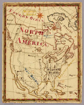
There are important exceptions here, for several of the intricate, artistic, and exacting maps that survive today were made by young men. In Londonderry, Vermont, Melvin Wright drew a large and elegant map of the state, flanked by detailed ornamental vignettes of regional history and geography that he copied from other sources. Bradford Scott made several maps of the western hemisphere in 1816, each of which reflects his attention to penmanship and calligraphy (see Figure 2). Lewis Woodruff carefully designed a map of the United States while studying at LFA in preparation for law school. Yet, in general, boys were probably learning to draw maps as working tools of the field, while girls prepared maps for competitions and performances oriented around artistic execution as much as the mastery of geographic knowledge. Map drawing was primarily—though never exclusively—the domain of female education.Footnote 28
Bradford Scott, “North America,” 1816. (Map courtesy of David Rumsey Map Collection, Stanford University.)

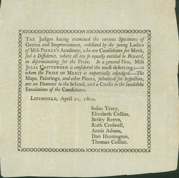
The intensely artistic dimension of these maps is itself revealing, for they were generally designed as public acts of learning, drawn to be seen, judged, and appreciated. In fact, most were bordered with ribbons or set on rollers for display in school competitions, fueling a robust trade for framing in the Connecticut River Valley. LFA was known for inviting notable members of the community to judge the students in oratory, artistry, maps, and charts (see Figure 3).
Announcement of Litchfield Female Academy Competition, 1802. (Courtesy of Litchfield Historical Society, Litchfield, CT.)

In 1820, sixteen-year-old Mary Elizabeth Hartt won an award for her embroidered map of the nation, stitched at the Steele Creek Female School in South Carolina. The meticulous execution of the maps marks them as the source of great pride—and no little frustration—particularly in schools such as LFA that prized performance and competition. These projects were designed to endure in an era when maps and atlases were costly and scarce.Footnote 29
Making the Map
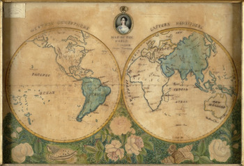
The practice of map drawing spread quickly, not only because it served several elements of the curriculum but also because it required little instruction or teaching expertise, and minimal materials or preparation. That so many examples were modeled on outdated maps is revealing. Harriet Hayles may have used a much older map as her model because current material was unavailable, but the goal might not have been strictly the mastery of geography. Students often used old maps, at times even representing antiquated geographies in their maps. When Catharine Sargent drew a highly stylized view of the world copied from a Mercator projection in 1791, she evoked an era of maritime discovery that had long since passed.Footnote 30 Whether stitched or drawn, some of the most common maps depicted the world on a double hemisphere (see Figure 4). Commonly available sewing patterns may have popularized these samplers, but they were also popular because the margins allowed for botanical or other decorative touches. Charles Lothrop and several other young men decorated their double-hemispheric maps of the world with floral borders throughout this period. Juliana Carpenter ornately framed her 1825 hemisphere map with lush botanical renderings, while Thankful Vincent's more restrained touches to her 1823 map sampler honored her Quaker identity.Footnote 31
Juliana Carpenter, “Map of the World,” 1826, 32 cm in diameter, on 46 × 69 cm sheet. Fifteen-year-old Juliana Carpenter drew and painted this elaborate double-hemisphere map, earning an award from her teacher at Cortland Academy in New York. Notice the detailed border, an effort to practice art but also knowledge of botany. (Map courtesy of a private collection.)

Aside from the world on a double hemisphere, the most common maps prior to 1800 were of particular areas, such as Sally Dodge's stitched map of Boston Harbor. By the 1810s, however, the most common subject of hand-drawn maps was the United States, no doubt a result of the wave of patriotism that swept through the country after the War of 1812. Sally Bartholomew and Bradford Scott modeled their national maps on Jacob Cumming's School Atlas just after the end of the war. Lydia Stiles was only eleven in 1816 when she mapped the United States as part of her studies at Catharine Fiske's school for girls in Keene, New Hampshire. Melissa Spelman drew a map of the nation at age thirteen in 1815, while Sarah Earle completed hers the following year. Interestingly, many of the maps drawn in the 1810s and 1820s—such as those drawn by Mary Johonnot—mark the prime meridian measured from Washington, DC, not Greenwich, England, a reflection of the short-lived nationalistic effort to create an American source of longitude.Footnote 32
Creating a national map was a demonstration of civic pride and a statement of national coherence, even a way for students to connect to fellow Americans whom they would never meet. As Mary Kelley observed, the widespread study of geography united a population that was both “spatially divided and socially diverse.” By extension, drawing these maps was a way to inhabit the national community, a step beyond the passive seeing of a map toward a more active declaration of membership—albeit constricted—in the national body. It made the abstract and unprecedented concept of American identity more concrete.Footnote 33 Having just opened the Middlebury Female Academy (MFA), Willard characterized this identity as uniquely female, insisting in an ebullient Independence Day address that women were peculiarly adapted to love their country and its territorial dimension, for “men can rove, but woman cannot transplant herself from her native soil.” Map drawing was a way to inhabit that identity.Footnote 34
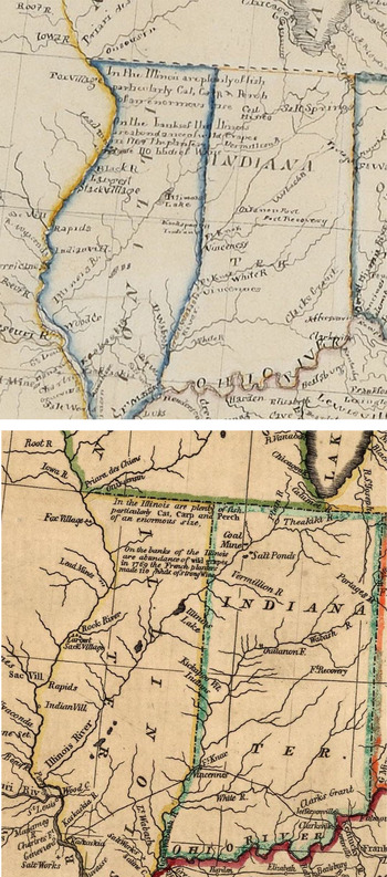
The process of making these maps varied widely. Some of these students meticulously copied and traced their maps, while others used latitude and longitude to scale up their map from smaller models. The most striking element of Chester's map is its fidelity to W. Shelton and Thomas Kensett's “An Improved Map of the United States” (see Figures 5 and 6).
Comparison of detail of the western territories in Caroline Chester's schoolgirl “A Map of the United States,” above top, with the published Shelton and Kensett “An Improved Map of the United States,” 1813, bottom, that guided her work. Caroline Chester's diligent effort to reproduce a national map was part of a popular school exercise to teach young girls several different skills. (Chester map courtesy of the Litchfield Historical Society, Litchfield, CT; Shelton and Kensett map reprinted from W. Shelton and Thomas Kensett, “An Improved Map of the United States.”)

Several other maps undertaken at LFA reflect a similarly high level of effort and discipline. Like Chester, Lucretia Deming undertook several maps after the War of 1812—of the United States and its states, Europe, and South America—all of which were guided by Mathew Carey's 1811 General Atlas.Footnote 35 Such replication demanded hours of concentration, though not necessarily intellectual engagement. Eliza Ogden similarly spent long afternoons on her map while a student at LFA in 1816, to the point that one wonders whether the project was primarily designed to keep her and her classmates occupied. The errors on her and other maps may signal the attention to lettering, sometimes even at the expense of spelling. The degree of mimicry exemplifies the principle of emulation so prized in female academies, though male examples bear the same qualities. Emulation was integral to accomplishment-centered schooling, and map copying may have fit into this existing goal. These time-consuming, sustained exercises also fit the lengthened school day that developed after the Revolution.Footnote 36
These projects appear to have been modeled on a range of available material, including hand-drawn maps by teachers themselves. This might indicate that teachers were having students draw maps without much guidance from textbooks or school materials. After 1820, however, students usually copied maps from more inexpensive school atlases, such as Sidney Edwards Morse's Modern Atlas. Martha Story used Morse to guide her large map of the nation, closely replicating its contours and shape. (See Supplementary Figure 1, available in the online supplementary material.) The precise artistic appearance of maps such as Story's reminds us that this task was often less about cartographic conceptualization than demonstrating the discipline and control required to replicate or emulate a map. Like so many others, Story placed a premium on calligraphy, political borders, coloration, and place-names, and re-created the formal elements of printed maps, such as margins and neat lines; oddly, however, she included no indication of scale. Lucy Tenney carefully copied nearly every detail of Osgood Carleton's master map of Massachusetts, down to the detailed icons in the legend. Yet she omitted his measurement of scale, perhaps using gridlines alone to guide her work. To be fair, text and atlas publishers such as Jedidiah Morse themselves often omitted measurement of scale, which is revealing, for it indicates that school geographies were often less engaged with the operations of mapping than with exposing students to the general appearance of a map or the general contours of landforms. For students, the assignment of creating a map in this era was often less about absorbing geographical relationships, or the meaning of cartography, and more about artistic execution.Footnote 37
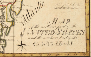
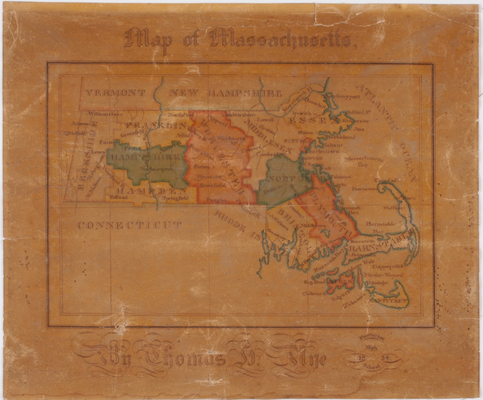
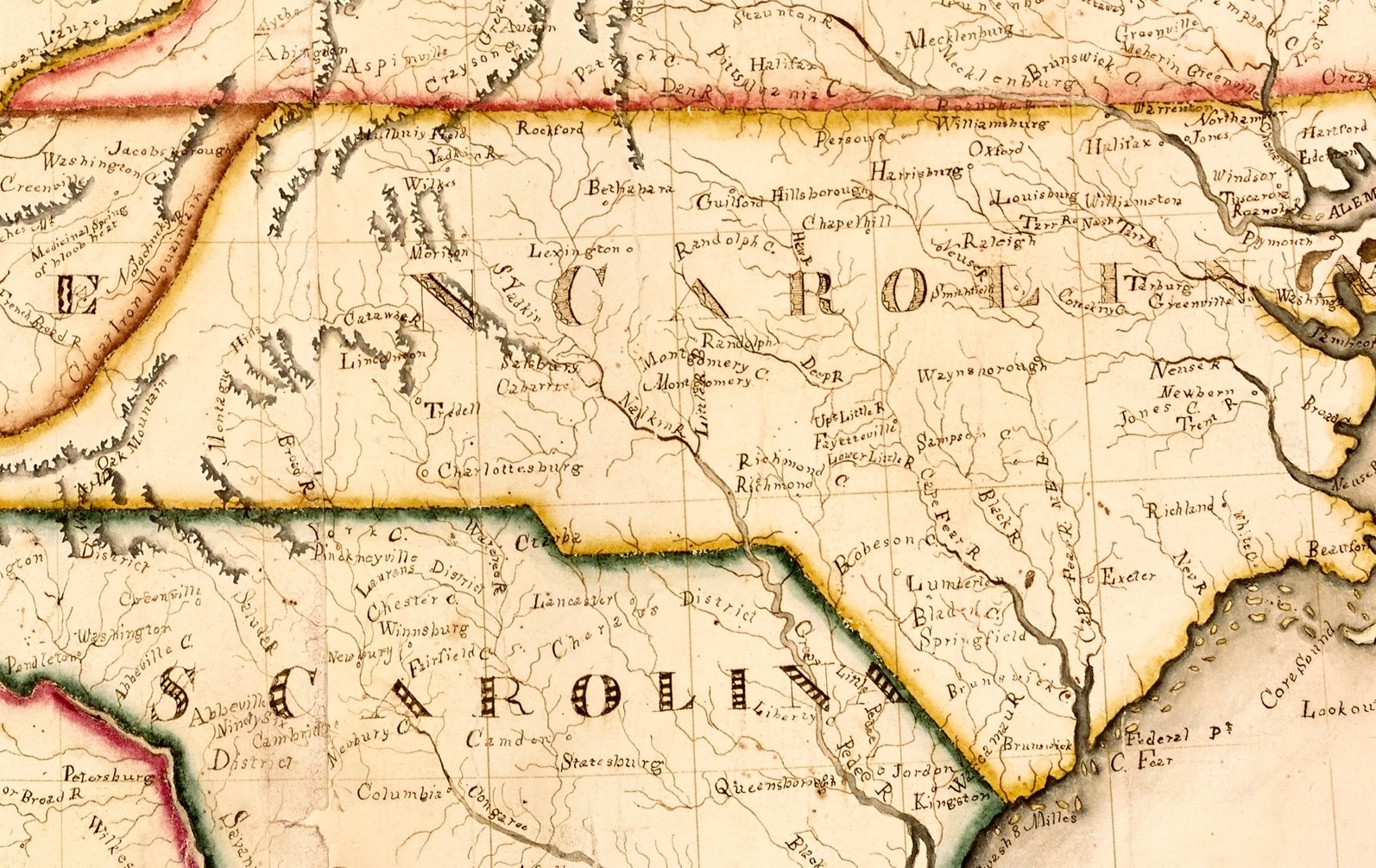
Yet inextricably tied to this artistic execution was the practical skill of penmanship, a mainstay of nineteenth-century schooling. The maps that survive—and which command healthy prices on the antiques auction market today—demonstrate that they were considered worthy of preservation, much of which has to do with their script and composition. In 1814, Mary Hall compiled her map of the United States from several different originals, painstakingly using distinct calligraphic hands to distinguish different types of place-names (see Figure 7). Similarly, Emily Hill drew an extraordinarily large map of the nation in 1820, employing several different letter styles in the process. The size of her map, made on papers sewn together, suggests that Hill was a teacher designing a tool of instruction. She also carefully articulated topography and borders, another indicator of the premium on artistic execution.Footnote 38 (See Supplementary Figure 2, available in the online supplementary material.) Thomas Nye completed his map of Massachusetts in Pawtucket High School in 1834, one that surely inspired pride for its precise hand and artistic execution. (See Supplementary Figure 3, available in the online supplementary material.) In these respects, map drawing and copying were an expression of both useful and ornamental goals of education. The fact that young men drew maps with the same ornamental calligraphy challenges assumptions about the rigidly gendered norms for penmanship. Boys were just as likely to ornament their maps with calligraphy, and just as likely to omit measures of scale and latitude in favor of artistic appearance.Footnote 39
Mary Hall, detail of “Map of the Northern Part of the United States,” 1814. Mary Hall's attention to lettering indicates that this map was at least, in part, a penmanship exercise. (Map courtesy of Osher Map Library, University of Southern Maine, http://www.oshermaps.org/map/926.0001.)

The same style of map drawing in female education was also widespread in Europe. In France, Celeste Babin's 1839 “Mappemonde Projetee” displays such exacting attention to artistic care that one can be forgiven for assuming it was a printed map of the world. At about the same time, Marianne Hunt devoted hours to her delicate and thorough atlas of the world, guided and praised by her tutor's marginal notes. Hunt's assignment—creating both physical and political atlases for different regions of the world—reflects the conventional division of geography that emerged at mid-century, inspired by Karl Ritter and Alexander von Humboldt. Across the English Channel, Frances Bowen's finely executed 1810 world atlas reflects a similar commitment to mastering geographic knowledge through artistic skills and penmanship. Mary Ann Thompson's intricate atlas of English counties (circa 1800) also marks attention to hand and coloration. Schoolgirls on either side of the Atlantic were drawing and stitching maps in the same tradition by the last quarter of the eighteenth century.Footnote 40
A Graphic Education
To explore the meaning of these exercises, we turn to Emma Willard, an architect of female education in the early nineteenth century. Willard encountered geography early through Jedidiah Morse's texts while studying with Thomas Miner in Hartford in the 1790s. She praised his willingness to challenge girls, but found the course in geography deficient, for “we learnt boundaries and latitudes from the book, giving little heed to maps.” Looking back, she keenly remembered what was lacking in her own geographical education.Footnote 41
Willard was then educated at female academies in Hartford, where she recalled a rudimentary yet typical and highly visual education hinging on grammar, geography, arithmetic, painting, music, and embroidery. Though she acknowledged the contribution of pioneers such as Pierce, she lamented that female education was premised on false assumptions and outdated pedagogy. Willard was especially intrigued by the cultivation of memory, a goal she shared with many others.Footnote 42 Pierce, for instance, had long stressed the importance of geography in developing principles of association and “readiness of memory.” By having students engage with nonfiction—primarily history and geography—their “sickly relish for fictitious writings” would be controlled.Footnote 43 Geography and maps constructively engaged the imagination in ways that would influence subsequent educators. At LFA, Pierce had students not just draw maps but chart information in unconventional ways to cultivate their minds. Betsey Clark charted the “faculties of the soul” in 1800; Marian Lewis chronicled human history in her 1815 picture of time; and Eliza Ogden extensively charted the history of English monarchs in 1816. All of these exercises at LFA were long-term projects designed to familiarize students with the organization of information as well as to practice penmanship and calligraphy.Footnote 44
A few miles to the north, in Northampton, Anne Laura Clarke began to use these same graphic skills in her newly opened home school, advertising an education rich in maps and charts. Clarke had been educated at Mrs. Patten's school in Hartford—known for its emphasis on embroidery—at the same time that Willard was enrolled nearby at a school run by Lydia Royce, engaging in the same types of needlework. Both Willard and Clarke were also influenced by the timelines of Joseph Priestley, which had for decades been popular tools to teach chronology and history. Clarke, in fact, adapted Priestley's model in the 1820s and 1830s to illustrate her highly popular lectures on European history.Footnote 45 Such examples of graphic learning were part of a larger era of visual experimentation. Maria Edgeworth championed globes to integrate history and geography, and she stressed the use of color to convey different regions of power over time. Through intentionally colored maps, she argued, “History, chronology, and geography, would appear at once to the eye in their proper order, and regular succession, divided into centuries and periods, which easily occur to recollection.” Edgeworth praised Abbé Gaultier, who used play and pictorial amusements to teach geography to the children of French exiles in London after the French Revolution.Footnote 46
Willard—like Clarke—was attracted to graphic styles of learning, in part, because they both had been exposed to this tradition in the female academies of Hartford. Willard's own childhood exposure to needlework may have developed her interest in spatial and visual knowledge. She also had a passion for drawing and painting, and she proudly remembered herself as “picture-maker-general” of the common school class. Her efforts to improve as an artist, she wrote, motivated her to master geometry. As she remembered, “I determined to understand perspective; and knew I must begin with geometry. . . the very ploughshare of the mind.” In 1804, Willard made the transition from student to instructor when she began teaching in her hometown of Berlin, Connecticut. She then found several positions in the Connecticut River Valley and New York before moving north in the summer of 1807 at age twenty to open a school in Middlebury, Vermont. She enrolled students for a few years in her home and, in 1814, took over MFA from Idea Strong. By 1816, over seventy students attended MFA, and Willard remembered this as the moment when she began to experiment with teaching, particularly with geography. As she recalled, Jedidiah Morse's geography was “good for a reading, but bad for study.” She began to think about how geography might be taught differently by stressing its comparative and pictorial dimension. She grappled with concepts of perspective and view, proudly recalling her mastery of Euclid as well as Charles Le Brun's drawing manual. These concepts and tasks, she recalled, led her to appreciate visual forms as superior in elegance and pedagogical effectiveness to verbal and textual information. Her early exposure to drawing shaped her understanding of how the mind works to acquire, understand, and retain information.Footnote 47
This intense interest in perspective and drawing may have also led Willard to teach her students not just to study and copy maps, but to reproduce them from memory. She regularly asked her students to draw maps to learn history and geography, and her particular techniques are apparent in a dense and detailed surviving manuscript made by one of her best students, Eliza Henshaw. The journal is filled with competent, neat, and detailed maps of individual countries, ones that attend not primarily to color or precision—like most maps discussed here—but rather to rough geographical form and outline, as if they were drawn from memory. As instructed by Willard, Eliza joined each of her maps with descriptions of the region, emulating narrative from geography textbooks or other lessons. Willard's drive to experiment with pedagogy was no doubt influenced by the location of her academy, adjacent to the newly founded Middlebury College (1800). Willard was “bitterly” aware of the gulf in accommodations that separated the two schools. This discrepancy and inequality between male and female educational access was all the more galling given Willard's claim that the college faculty considered her students’ recitations superior to their own. It was this discrepancy between male and female education that moved her to begin developing a plan for female education in 1816. The plan eventually won support from Governor DeWitt Clinton in New York, and laid the foundation for Troy Female Seminary, which opened in 1821 and educated twelve thousand girls in its first half century.Footnote 48
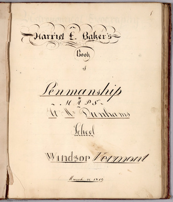
This integration of visual and textual characterized Willard's highly successful geography and history textbooks in subsequent decades. Here she was part of a larger trend, for a variant of this approach is apparent in four penmanship journals from female academies in northern New England. These manuscripts included not just maps but intensely graphic arrangements of information. The earliest of these, by Caroline Burroughs, remains a mystery, since it bears no location, school, or date. She probably wrote this journal between 1809 and 1815, though it is difficult to date her project, given that she was working from older maps. Catharine Cook produced her journal while enrolled at Josiah Dunham's illustrious Windsor Female Academy (WFA) in Vermont in 1818. Harriet Baker completed a similar project at the same school in 1819 (see Figure 8). Seventy-five miles to the west, Frances Henshaw—younger sister to Eliza—finished her penmanship journal in 1823 while at MFA, immediately after Willard herself left to launch Troy.Footnote 49 (See Supplementary Figure 4, available in the online supplementary material.)
Harriet Baker, penmanship journal page, 1819, Windsor, VT. Baker's project at the Windsor Female Academy was part of a larger trend that integrated penmanship, geography, and map drawing. (Image courtesy of David Rumsey Map Collection, Stanford University.)

These four manuscripts are remarkably similar in size, structure, and content. Each opens with a long narrative section that reproduces information related to geography and history through careful calligraphy and penmanship. Cook, Baker, and Henshaw used ornate script to reproduce passages on climate, astronomy, and the discovery of America from an earlier edition of Jedidiah Morse's Geography Made Easy.Footnote 50 In each of the four journals, students were learning through emulation, an essential component of eighteenth-century education. By copying important passages, students—or their teachers—hoped they would “internalize the style and substance of their betters.”Footnote 51 In the penmanship renderings of these long narratives, students were not only reproducing narrative but experimenting with graphic and visual learning. In each journal, textual material was delicately laid out in angled or other geometric fashion, employing ornamental styles that might have also endured from eighteenth-century calligraphy and penmanship manuals. Perhaps writing out material in unconventional modes and patterns gave the material a tangible quality, thereby imprinting it in the student's memory. In fact, some of these arrangements are so stylized as to assume the appearance of quilt work, which itself may have exposed them to the graphic and spatial precision that these assignments demanded.Footnote 52
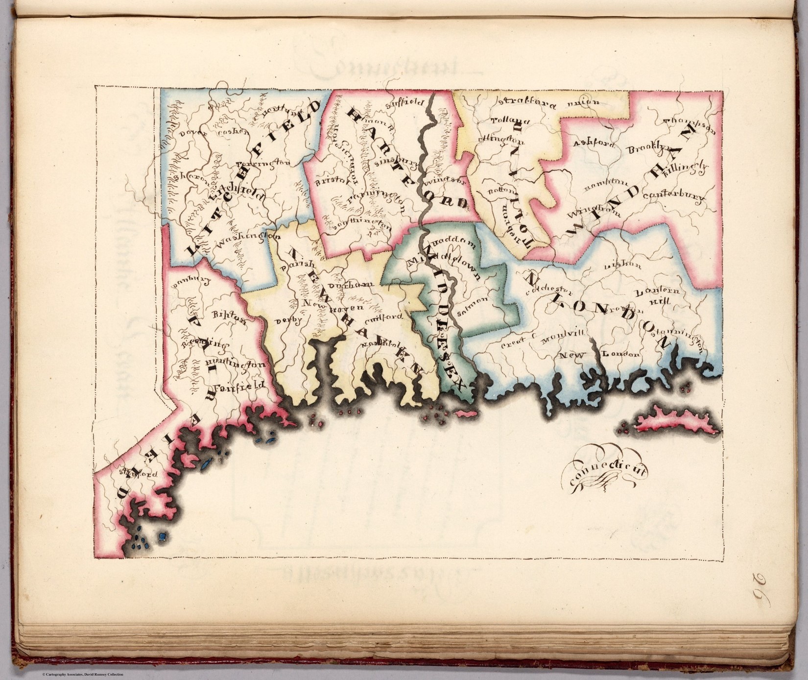
This graphic arrangement of information in these journals was occurring at the same time Willard was experimenting with geography at Middlebury. The artfully arranged narrative in these penmanship journals, however, was just the introduction to manuscripts that were thoroughly visual. Burroughs drew eighteen maps in her journal, all of which were taken from Jedidiah Morse's American Gazetteer. Henshaw's nineteen maps profiled each state, all but one of which was drawn from Carey's American Pocket Atlas (1805). Cook drew nine state maps—beginning with New Hampshire and Vermont and moving south to New York and New Jersey before discontinuing her project—and included descriptions for every state in the Union. Similarly, Baker's unfinished journal does not have maps of every state, but those that she completed show exceptional pride and attention. The maps of Cook, Baker, and Henshaw are beautifully colored, lettered, and designed. Baker, in fact, executed her coastlines, borders, and place-names with an astonishingly acute eye for detail, and the result are maps so polished as to approximate the look of engraving. (See Supplementary Figure 5, available in the online supplementary material.) Burroughs's maps are more loosely composed and reflect attention to geographical lessons more than presentation and execution, but they are equally dense with information. Each of these girls focused her penmanship journals on the United States.
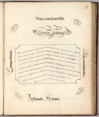
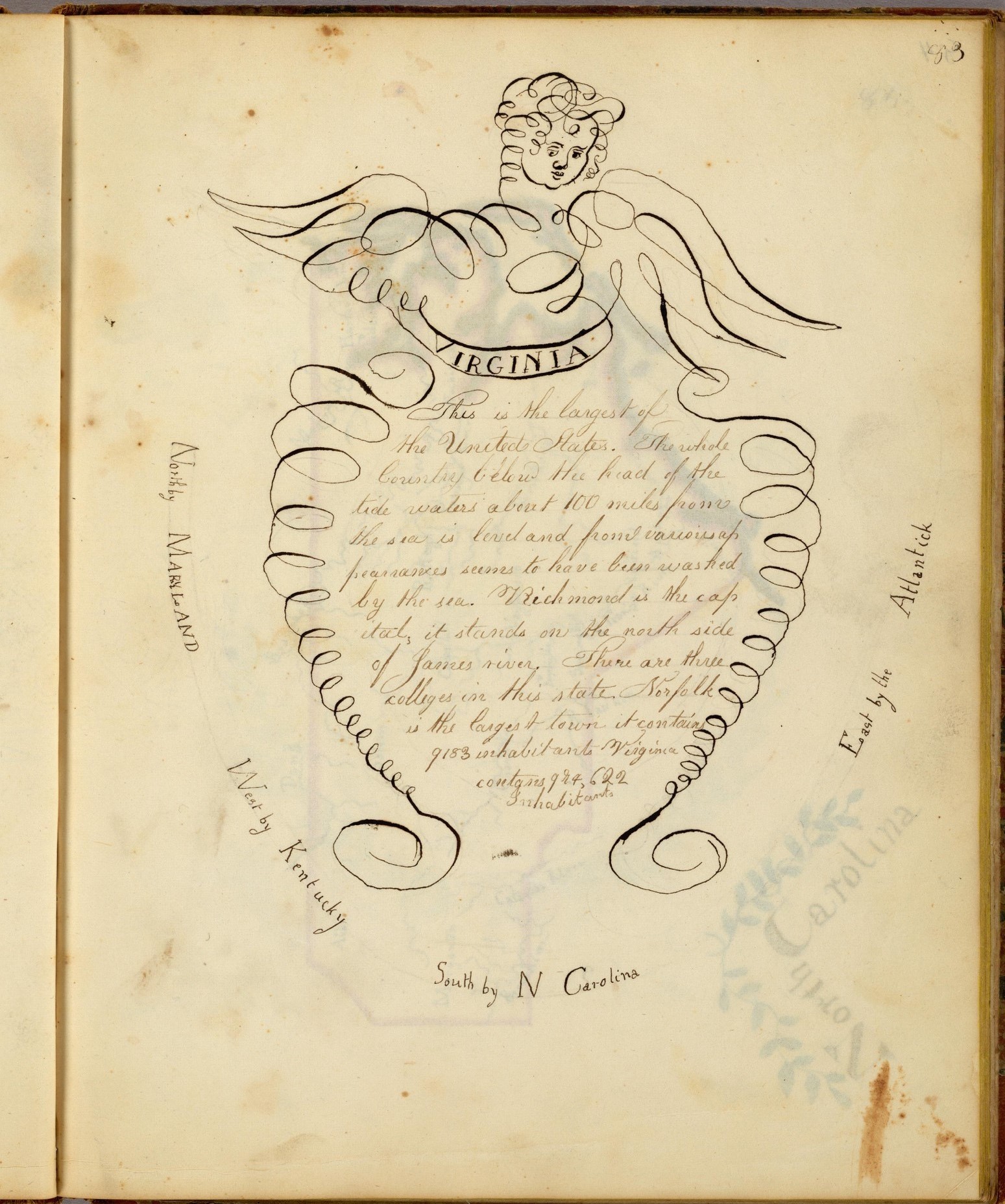
Beyond this, the penmanship journals share another very revealing quality: each included carefully composed “word maps” that arranged information geographically. Such a practice may have its roots in Jedidiah Morse's word maps designed for elementary readers, where place-names were positioned on the page in geographically appropriate ways. Henshaw's delicately penned descriptions of New York State were “bounded” by geographic features to the north, south, east, and west. Burroughs created over thirty word maps to exhibit her mastery of geography and calligraphy. Small iconic flourishes round out each picture, demonstrating her artistic talent and extending the graphic associations of the information for the mind. Henshaw copied the cherub's head from the title page of Eleazer Huntington's penmanship book in her narrative description of Virginia, then bounded her description of the state by listing all the surrounding states and bodies of water. (See Supplementary Figure 6 and 7, available in the online supplementary material.) The journals of Henshaw, Burroughs, and Baker are filled with efforts to give information a spatial form, no doubt in the service of memory (see Figure 9).Footnote 53
Massachusetts “word map” from Harriet E. Baker's Book of Penmanship and Maps, 1819, 25 × 19 cm. This word map arranged information geographically to help students practice penmanship, knowledge of states, and orientation. (Image courtesy of David Rumsey Map Collection, Stanford University.)

Map Drawing and Educational Networks
The sheer detail of these penmanship journals suggests that they extended over many months and required superior self-discipline and talent. In addition, the striking similarities between the Baker, Cook, and Henshaw journals in both appearance and structure indicate that the same teacher directed these efforts, or that a network existed where teachers exchanged exercises and practices. Baker and Cook completed their work at the newly launched WFA, which attracted elite families from Vermont and western New Hampshire after 1814. Led by Dunham, the school prided itself on a progressive curriculum that exposed girls to both common and higher subjects of moral philosophy and natural history. This might explain the highly stylized quality of these journals, methods of learning not only penmanship but history, geography, and art. In this regard, they echo and parallel the particular needlework styles that characterized certain female academies. These journals also reveal something about the larger dynamics in female academies. Recently, Bethany Nowviskie discussed Henshaw's remarkable journal as the product of a graphic impulse that Willard had established at MFA, one that remained even after she left to found Troy in 1819. Yet these penmanship journals, such as Sally Tate's from the 1790s, document that the emphasis predated Willard. And if we acknowledge the extent of map drawing from the 1790s to the 1830s, Willard becomes a product of this web of schools that had long engaged with graphic learning.Footnote 54
In the same way that Willard was both a product of and an influence over visual learning, Eleazer Huntington was inextricably connected to the dense community of academies in the Connecticut River Valley that had emphasized penmanship as essential to female education since 1800. Huntington was an engraver in Hartford when he issued his first guide to penmanship in 1816, and the text soon became a standard-bearer in female schools. But his very decision to compile and publish such a guide was a product of his experience in Hartford, dense with the pedagogical experiments taking place all around him at female academies. In this respect, Huntington was both responding to and influencing the direction of American education by developing materials that captured these experiments. The wide adoption of his texts was extended by girls who were educated in this tradition and then went on to teach elsewhere.Footnote 55
Relatedly, the practice of map drawing probably spread not through published texts—for few exist in these early decades—but rather through informal networks. For instance, Mary Read was a teacher at Fiske Seminary in Keene, New Hampshire, around 1816, where Lydia Stiles and Mary Anne Russell made maps. She then taught with Josiah Dunham in Windsor, Vermont, the following year. Might she have brought her experience drawing maps to Dunham's school, where young girls were taught to conceive of geography through maps and other graphic forms?Footnote 56 Similarly, Caroline Hale graduated from Dunham's school and then went on to teach Juliana Carpenter to draw maps at the Cortland Academy in Homer, New York. Lucy Burnap taught at Woodstock, Vermont, in 1814, then spent time teaching in Fayetteville, Vermont, in 1818 before taking over MFA after Willard left to launch Troy. Might Burnap have brought her experience with mapping to Middlebury, where Willard was already experimenting along similar lines? Linda Raymond was a student at Burnap's school in 1814 before moving to Catherine Fiske's school in Keene in 1815, both of which included map drawing. The frequent movement of students as well as teachers meant that these practices traveled swiftly. And in an environment of transitory teaching with relatively limited curricular materials, one's own teaching experience and exposure became even more important.Footnote 57
Map drawing in schools also raises questions about how we understand the history of pedagogy. William Gilmore's exhaustive study of reading habits in Windsor, Vermont—the very town that spawned Josiah Dunham's school for girls—establishes the decades from 1780 to 1835 as one of exploding literacy and access to the printed word. Among the most widely circulating texts of this era were Morse's geographies, outranked only by the Bible and Noah Webster's spellers. But Gilmore's investigation of reading ignores nontextual information—maps, charts, and other visual material—that also proliferated in these years. Martin Brückner has argued that geography spread not just in schools, but also became part of everyday discourse, and maps part of a common linguistic identity. Graphic and cartographic exercises were integral to the curriculum at WFA, exposing students to maps as meaningful representations of information. The experience at Windsor was not unique among female academies, many of which were awash in an intensely graphic form of learning that antedated—and may have even prompted—the spread of maps through formalized pedagogies, textbooks, and atlases. In the case of map drawing, classroom practices may have shaped formalized pedagogies, rather than the reverse.Footnote 58
Johanna Drucker has coined the term graphesis to evoke the ways that visual forms organize information into meaningful, useful pictures in the digital age, and the term may also help us understand styles of learning in the early republic. The widespread adoption of map drawing in female—and occasionally male—schools produced educators who, in turn, published their own lavishly graphic teaching materials. Consider the school texts of William Woodbridge and Willard in the 1820s, or the inexpensive atlases of Daniel Adams and Sidney Edwards Morse in the same decade. Willard's goal was a traditional one—to sharpen and improve one's memory—so visual and cartographic learning appealed to her as a mnemonic device. For her, the interest was in how we learn in order to remember, so her publications are dense with graphic material. Her first published visual tool was a graphic “map” of Roman history, where time was represented by the Amazon River as a way to profile its scope and scale. She also authored the first historical atlas of the United States in 1828, aided by a former student, then spent years experimenting with graphic devices, such as the Temple of Time, the Tree of Time, the Stream of Time, and others.Footnote 59
Willard's graphic innovations, however, were not without competition. Anne Laura Clarke—who had also been educated at Hartford—thrilled audiences around the country with historical lectures illuminated with detailed time charts that she attempted to copyright in 1825. These were quite similar to the type that Willard would experiment with in the 1830s. Thus, when Clarke lectured at Troy Female Seminary in 1826, she probably expected a kindred spirit in Willard, yet she was initially greeted with frosty indifference. Such an encounter may have been fueled by Willard's sense that Clarke—educated in the same tradition—was also using visual techniques to advance an “original” approach to history and geography. More to the point, their rivalry underscores the creative energy around graphic learning in the 1820s and 1830s.Footnote 60
Clarke never published her charts, while Willard spent the 1820s and 1830s assertively writing, illustrating, and publishing a series of geography and history texts. By the late 1820s, she had become a leading textbook publisher, in part due to her collaboration with Woodbridge. Influential educational reformers such as Joseph Emerson praised their plan of geography for its comparative approach and use of thematic mapping. Willard's history of the United States was widely adopted, especially for the series of historical maps that accompanied the first edition in 1828. Her textbooks were ubiquitous in northern schools, but reached into the southern states as well, enthusiastically adopted in both South Carolina and the frontier. Miss C. M. Thayer, the New York-educated headmistress of the reputable Elizabeth Female Academy in Mississippi, had long emphasized map drawing in her curriculum and praised Willard's texts for their liberal use of maps and other graphic tools. Inspired by Willard—and more fundamentally by Johann Pestalozzi—Thayer approached geography by emphasizing direct observation by the student. First, she had girls notice the school grounds, then draw a map that translated that observation onto paper. Mapping exercises then gradually moved outward, encompassing her village, her town, and finally her nation. These steps of increasing abstraction, Thayer argued, helped the student gradually enlarge her world as well as apprehend the nature of cartographic representation. The goal was for each student to draw states and country with “accuracy and dispatch, without a copy. . . from memory alone.” The distinction here seems worth considering: some teachers had asked students to copy maps, while Willard, Thayer, and others emphasized mental maps that could be recalled and reproduced from memory. Clearly, map drawing could be used for a wide variety of goals, though the larger aims remained fixed around memorization.Footnote 61
Willard's influence was just as directly felt through the thousands of young teachers whom she trained at Troy from the 1820s to the 1870s. Drawing remained central, and even grew in importance at the seminary in the 1830s and 1840s, a reflection of Willard's conviction that visual and spatial skills were the best means to cultivate mental discipline. Maps also remained common fixtures in the classroom, and Willard's own antebellum texts are littered with graphic learning experiments. Her own education had led her to experiment with techniques that would influence countless women who became teachers. Willard was representative in this respect: early nineteenth-century female education was intensely visual and produced women who adopted that approach in their teaching.Footnote 62
The Critique of Map Drawing
In fact, map drawing had become so commonplace that it began to draw scrutiny in the 1820s. Consider the observations made by Willard's sister, Almira Phelps, founder of the highly regarded Patapsco Female Institute in Maryland and an established pedagogical reformer. In 1831, Phelps spoke to the students at Troy and praised Willard's pursuit of the ideal female curriculum. In a lecture on geography, Phelps reflected on the diverse methods of teaching geography. Early in the century, she observed, students were limited to the texts of William Guthrie and Jedidiah Morse, which were both devoid of nontextual material. Even with the introduction of atlases, Phelps pointed out, “No attempt was made to teach the drawing of maps, except in a laborious and unprofitable manner, which occupied weeks, and even months, with little other advantage than that of giving to the pupil neatness of execution.”Footnote 63 This meticulous attention to detail did little to teach young women the larger concepts of geography.
[While the] maps had a very pretty appearance. . . the mind of the pupil was usually too intent on the mechanical performance to think of the relative situation of places. A young lady, after spending three months at a boarding school, and having drawn and painted a map, was considered as well versed in geography, though in truth she might be almost as ignorant of the science as the unconscious material on whose surface her map had been delineated.Footnote 64
This state of affairs, Phelps insisted, was just what Willard rebelled against when she introduced map drawing at Middlebury in 1816. Phelps argued that most female educators used maps in a way that had little to do with teaching geography. And while Phelps predictably favored her sister's work, more relevant here is her conscious effort to differentiate Willard's approach to instruction from those of her competitors and predecessors. Surveying the landscape of contemporary female education, Phelps saw many students creating maps. The key was how these tools were used to engage young women. Not surprisingly, Phelps championed Willard and Woodbridge's published plan of geographical education as a pathbreaking model that grew out of Willard's own experience at Middlebury and Troy.
Phelps's comments reveal the changes taking place, some of which predated Willard but which she catalyzed as a well-known and widely published educator. As Kim Tolley has argued, geography paved the way for more advanced sciences in female education, including natural philosophy, chemistry, algebra, and botany. By the 1830s, there was also an increasingly competitive market for educational materials, itself a result of the spread of female schools. Phelps's dismissal of the “ornamental” style of map drawing—one that placed a premium on appearance and accuracy of replication rather than the ability to reproduce and understand geographical relationships—was not unique. Several educators began to challenge what they deemed a mechanistic and abstract approach to geography and mapping. The pedagogy of geography was under scrutiny.Footnote 65
One such critic was Joseph Emerson, who launched two female schools and infused both with the study of geography and maps.Footnote 66 Sophia Sawyer, for instance, remarked on the highly visual education she received at Emerson's Byfield Academy in 1820.Footnote 67 Like Phelps, Emerson was frustrated by the brittle and superficial role of maps in the contemporary female curriculum. Most schools, he argued, typically assigned students to use and draw world maps without any understanding of orientation, scale, latitude, or longitude. In this context, the map had little meaning for the student, an abstract representation of space that could not be grasped in a dynamic way. Rote questions—with clearly memorized answers—made the situation worse, hindering any true apprehension of cartography. Much better, he wrote, to begin by translating the concept of a map at the local level, mapping a garden or a field, and then working outward to towns and regions, states, and nations. The problem, Emerson observed, was that students learned the “mere signs of Geography,” rather than the subject itself. They learned to memorize a map, but missed its properties or operation, engaging with maps yet failing to understand information encompassed by maps. He negatively contrasted this tradition with Willard and Woodbridge's comparative approach to geography.Footnote 68
Woodbridge himself echoed Emerson's critique of contemporary geography's focus on the map as an abstract object rather than as a complex method of representing spatial relations. The result was a generation that looked on a map and saw place-names rather than “lofty forests. . . beautiful, cultivated fields. . . or. . . villages.” The superficial emphasis on the map as an end in itself left students preoccupied with the “lines and spots” rather than “the great objects they represent.” Like Phelps, he wrote, “We have no patience with those who thus teach their pupils a science, which may be called Chartology, but has no more title to the name of Geography, than the giving names to an equal number of Chinese characters.”Footnote 69
Similarly, James Carter and William Brooks objected to the misguided approach to maps that dominated New England education. Carter and Brooks insisted that mapmaking begin not with mimesis but by representing and sketching local and familiar landscapes on the page. By beginning with national and world maps, students were necessarily disadvantaged, for whom among them could grasp the scale of a world map? They argued it was only when pupils could draw maps from memory—ideally county maps—that genuine mastery of geography was demonstrated. Arathusa Fisk drew such a map of Worcester County in 1834, detailing the interior township borders in a fashion that was perhaps guided by Carter and Brooks's text.Footnote 70 Emerson, Willard, Woodbridge, Carter, and Brooks developed their materials and ideas through classroom experience, teaching young women and men in intensely visual environments. All had students draw maps to teach geography and other subjects, and then went on to create materials, texts, and atlases that reflected this practice. And all advanced a pedagogy modeled on Pestalozzi's emphasis on local and familiar geography that gradually extended outward. In this framework, mapping was just as essential, but derived from direct observation rather than beginning with the most abstract concept of astronomical and world geography. Maps that replicated world hemispheres, or the nation, ran counter to the insistence that the student first apprehend her immediate surroundings and then understand how that perception would be represented and abstracted through a map. The use of Pestalozzian principles to critique the style of map drawing that dominated early nineteenth-century education anticipates the turn toward “home geography” at the end of the century. Yet studies of geographical education at late century suggest that many of the practices criticized by these reformers remained integral to geography textbooks and curricula.Footnote 71
These pedagogical critiques underscore how ubiquitous the artistic approach to map drawing and copying had become by the 1820s. They also anticipate the decline of the practice, attributable to several factors. First, the rise of coeducation delegitimized school traditions that were associated with female schools. Betty Ring cited a “war against ‘accomplishments’ in female education” by the 1830s, which took its toll on embroidery and these artistically focused maps. Ring singled out Willard, Woodbridge, and Catharine Beecher for “zealously” advancing a notion of female education that dismissed needlework. As Ring argued, the social upheaval of the industrial revolution—compounded by the zeal of these reformers—spelled the death of needle arts as a source of female education.Footnote 72 Indeed, Beecher remembered map drawing as essential to the education around “accomplishments” at LFA. She lamented that her own education occurred before the “higher branches” entered female schools, leaving her and her sister to the drudgery of “map-drawing, painting, embroidery and the piano.”Footnote 73
It was true that Willard chafed at the limitations of female schooling and argued that girls were overly educated in “the charms of youth and beauty.” Yet these student maps confound the division between “useful” or “ornamental” that Ring invokes. Willard continued to champion memorization and was, in fact, dismissed by later educators for exactly this preoccupation. For Willard, penmanship was both artistic and useful and, if anything, she points to the false dichotomy between the two. For young men, penmanship was a marker of education itself as well as an eminently applicable skill. For women, too, a polished hand could aid family businesses or even support female employment within the home. Penmanship—like map drawing—was also essential for teaching, the most common vocation for girls attending Willard's school. To the extent that map drawing and geography journals engaged with penmanship, then, they could be both traditional and ornamental on the one hand and progressive and practical on the other.Footnote 74
The decline of the practice of elaborate, intricate hand-drawn maps may also have had something to do with the increased availability of published cartographic material. Though a few school atlases included outline maps in the early nineteenth century, they were relatively rare and expensive. By the 1840s, far more students had access to the mass-produced outline maps of George Fitch, which enabled them to “fill in” the blank map rather than produce something on their own. Lydia Weeks and Sarah Budington “worked” their maps on Fitch's outlines, which even included a printed space for their name on the map, formalizing what previous generations had done with their own intricate hand. Quite simply, the increased availability of published student materials substantially diminished the need to draw elaborate maps.Footnote 75
Yet map drawing did not disappear. Instead, it became part of established curricular approaches, and the informal techniques so apparent in the early part of the century evolved into more formalized, pedagogically driven exercises that reflected the philosophy of Pestalozzi. William Bentley Fowle, an educator in Boston, issued a series of school texts and pedagogical manuals that emphasized map drawing, penmanship, art, and geography. Fowle proudly cited “the elegant writing, printing, and map-drawing performed” by his pupils, suggesting the persistence and integration of these skills well into the 1840s. In his texts, Fowle relentlessly critiqued existing methods of teaching map drawing, and then advanced his own presumably more refined and thoughtful techniques. But, of course, his pedagogy was itself an outgrowth and product of a culture that was immersed in this practice. Map drawing was everywhere in the early decades of the nineteenth century, particularly throughout the schools and academies in his home state of Massachusetts.Footnote 76
The rise and decline of map drawing constitutes an important episode in the history of education. In the earliest years of the new nation, many girls—and quite a few boys— spent long hours drawing, tracing, stitching, and ornamenting maps of their state, nation, and world. These artifacts—along with diaries and other related sources—offer a rich window onto the daily experience of education, which is particularly important given that this was the first generation of girls to receive higher-level schooling. These map projects served multiple curricular goals, especially geography, calligraphy, penmanship, and art. Map drawing was thus a highly useful way for teachers to keep students occupied and engaged over long periods of time, and to prepare them for the constant culture of public examination, performance, and exhibition. The rapid growth of this practice records an active network of teachers throughout the nation who strained to fulfill the demand for female education that integrated both ornamental and useful elements.
Moreover, the spread of map exercises in the early republic shows us an intriguing instance where the adoption of classroom practices came not via prescriptive ideals or curricular mandates, but through teachers who themselves had likely been educated in these traditions. The widespread practice of map drawing also documents an intensely visual and graphic classroom culture. The varied styles of these maps indicate that map drawing was highly adaptable: while one teacher might have assigned a map sampler as a mark of accomplishment, her daughter may have had students draw maps as a gateway to civic education. Whether serving to cultivate memory or more progressive goals of spatial thinking, maps were at the heart of early nineteenth-century pedagogy. The exercise fit exceedingly well in an era of rapidly expanding—if fluid—educational opportunities for young girls.
More generally, the demise of this practice marks the earliest stages of a shift toward “home geography” and social education inspired by Pestalozzi, where geography and maps became a way to explore the realm of the student rather than the world beyond her horizon. Carter, Brooks, Emerson, Phelps, Woodbridge, and Willard rejected the rote approach to map drawing when students had yet to apprehend the nature of maps or their immediate world. But these critiques themselves demonstrate how common map drawing had become by the 1820s. Over the course of some forty years, this pedagogy produced artifacts that students and their families prized and preserved for two centuries, and which collectors and archivists actively seek on the market. Whether drawn, painted, or stitched, authored by boys or girls, mapmaking was essential to early nineteenth-century education.
Supplementary Material
To view supplementary material for this article, please visit https://doi.org/10.1017/heq.2017.2.