INTRODUCTION
The political, economic, and social changes that swept across Mesoamerica after the close of the Late Classic period (a.d. 600–800) has been a central issue since the advent of scholarly interest in pre-Hispanic history. Evidence for increasing political and ideological links between western and eastern Mesoamerica were first documented at the cities of Tula and Chichen Itza (Chi Cħeen Itza Footnote 1 ). Early theories to explain pan-Mesoamerican links in architecture and material culture combined indigenous historical accounts recorded during the contact period to interpret the historical links between the two cities. This research drew on indigenous accounts charting migrations and invasions of historical figures, lineages, and ethnic groups as a basic framework to understand sociopolitical dynamics originating at the close of the Classic period. In these narratives, archaeological evidence for increasing links between eastern and western Mesoamerica including distinctive forms of architecture, urban planning, and art styles were associated with the spread of “Mexican” groups with links to the Gulf Coast and central Mexico (Pollock et al. Reference Pollock1962; Roys Reference Roys, Pollock, Roys, Proskouriakoff and Smith1962; Thompson Reference Thompson1970). Central themes in these reconstructions included (typically facile) correlations between material culture traits and historically documented groups, including the Itza, Olmeca Xicallanca, Toltec, Putun, and Nonoalca. Subsequent research has challenged or contradicted many of the central elements of these models, particularly chronological relationships between “Old” and “New” Chichen Itza and its relationship with Tula (see contributions in Kowalski and Kristan-Graham Reference Kowalski and Kristan-Graham2007).
A central figure in many indigenous accounts was the mythical personage or god Quetzalcoatl/Kukulcan (see Glossary and Appendix B). The nature and significance of this figure as a historical individual, mythical ruler, or deity—and his relation to Feathered Serpent iconography—has been a source of significant debate (Baldwin Reference Baldwin1998; Florescano Reference Florescano and Hochroth1999; Gillespie Reference Gillespie1989; López Austin Reference López Austin1973; López Austin and López Luján Reference López Austin and Luján1999, Reference López Austin, Luján, Carrasco, Jones and Sessions2000; Nicholson Reference Nicholson2001; Ringle et al. Reference Ringle, Negrón and Bey1998). While uncritical acceptance of indigenous narratives as historically accurate accounts and projection of these sources into the pre-Hispanic era is problematic (Gillespie Reference Gillespie, Kowalski and Kristan-Graham2007; Gunsenheimer Reference Gunsenheimer and Prem2003; Smith Reference Smith, Kowalski and Kristan-Graham2007), indigenous histories provide an important window into the role of migration and foundation myths in political narratives late in the pre-Hispanic era.
Contemporary views of the relationship between increasing similarities in political/religious symbolism, iconography, architecture, and material culture traditions have shifted from invasion and migration models to theories focusing on interaction, economic integration, and the spread of shared political-religious ideological charters across Mesoamerica during the Epiclassic and Postclassic periods (López Austin and López Luján Reference López Austin and Luján1999, Reference López Austin, Luján, Carrasco, Jones and Sessions2000; Ringle et al. Reference Ringle, Negrón and Bey1998). From this perspective, architectural, artistic, and ceramic links among a network of important centers in the Epiclassic period was part of a new world order melding religious and political messages. These dynamics were intricately linked to a pan-Mesoamerican religious cult associated with Quetzalcoatl/Kukulcan. This network included several Epiclassic (a.d. 800–900/1100) and Postclassic (a.d. 900/1100–1500) cities in the Maya area, the Gulf Coast, and central Mexico. This transitional period also witnessed radical changes in regional economic systems, trade networks, systems of governance, and the ways in which political power was legitimized and reinforced. In aggregate, these histories provided both a geographical outline of interpolity relationships that defined the political landscape of the Epiclassic and Postclassic periods as well as a fictive genealogy of power that functioned to link elites across disparate parts of Mesoamerica. These narratives were a central element in the negotiation of political legitimacy for several centuries.
Mythical narratives associated with Quetzalcoatl/Kukulcan reflect important links between polities that transcended political, cultural, and linguistic boundaries. When viewed from the level of pan-Mesoamerican cultural dynamics, the three types of interpolity connections outlined in this paper formed a symbolic political infrastructure. As the origin and purveyor of Toltecoyotl, or just and pious leadership, Quetzalcoatl/Kukulcan played a central role in this new geopolitical order as archetypical ruler and source of political legitimacy. Mythical accounts tracing the migrations of this individual across Mesoamerica, and his role in the foundation of cities and ruling dynasties, was a central component of an emergent political ideology based on fictive descent. Changing settlement patterns and urban traditions across Mesoamerica—including establishment of coastal cities, more nucleated forms of urbanism, and adoption of common forms of epicentral urban planning—suggest that the founding of cities played a major role in these developments starting in the Epiclassic period and continuing into the Postclassic period.
This paper traces mythical accounts relating to the development of pan-Mesoamerican international relationships associated with this emergent politico-religious order. In the sections below we outline information from indigenous histories pertaining to connections between pre-Hispanic cities throughout Mesoamerica along the migration route associated with Quetzalcoatl/Kukulcan. Migrations between centers across the Yucatan Peninsula and beyond were associated with three types of symbolic or real infrastructure networks: terrestrial roads (sacbeob or zac beob), celestial avenues (cuxaan zumoob, meaning living, blood-filled rope or cords that connected cities or individual deities), and underground roads (zahcaboob, white cave or sascab mine; Diccionario de Motul II ca. 1580; Solana ca. 1580). These three types of physical links between centers were metaphorical reflections of the high degree of socio-cultural and economic integration between centers which began to crystallize at the end of the Late Classic and continued into the Postclassic period. These linkages are consistent with the hypothesis proposed by Ringle et al. (Reference Ringle, Negrón and Bey1998) and López Austin and López Luján (Reference López Austin, Luján, Carrasco, Jones and Sessions2000) about the cultural importance of the god Quetzalcoatl/Kukulcan in the Epiclassic period based on the distribution of shared styles of material culture, including architecture, art, and ceramics.
HISTORICAL CONTEXT: CHANGING MESOAMERICAN INTERACTION SPHERES
The development of increasing pan-Mesoamerican linkages between eastern and western Mesoamerica is a fundamental characteristic of the Classic to Postclassic transition. Similarities between the distant cities spread across ancient Mesoamerica—particularly Chichen Itza and Tula—provided clear evidence for changes in the geopolitical landscape and the adoption of shared symbolic systems. Researchers such as Brinton (Reference Brinton1882) and Charnay (Reference Charnay1885) used Contact period indigenous histories to interpret historical links between these two cities, a method later expanded upon in seminal studies by Carnegie Institution researchers such as Tozzer (Reference Tozzer1957) and Roys (Reference Roys1933, Reference Roys1957, Reference Roys, Pollock, Roys, Proskouriakoff and Smith1962, Reference Roys1966) to identify common central themes in myths and historical narratives across Mesoamerica.
Based on this framework, changes between the Classic and Postclassic periods were interpreted as the result of migrations and invasions of ethnic groups documented in ethnohistoric sources. Tozzer's (Reference Tozzer1957) research on the link between Chichen Itza and Tula was among the first to combine ethnohistorical data to develop pre-Hispanic archaeological chronologies, including the basic chronological framework dividing Chichen Itza into Old (Puuc Maya) and New (Toltec) sectors. These observed similarities included site layout, architectural styles (I-shaped ballcourts, tzompantli, and colonnaded buildings), and new sculptural styles (such as atlantean figures, chacmool monuments, feathered serpent columns, and military and sacrificial scenes; recent literature on these relationships include Jones Reference Jones1993a, Reference Jones1993b; Kowalski and Kristan-Graham Reference Kowalski and Kristan-Graham2007). In these narratives, the strong archaeological evidence for increasing links between eastern and western Mesoamerican cultural areas was interpreted as the result of invasions, with the spread of “Mexican” traits traced through incursions of ethnic groups with supposed links to the Gulf Coast and central Mexico (Pollock et al. Reference Pollock1962; Roys Reference Roys, Pollock, Roys, Proskouriakoff and Smith1962; Thompson Reference Thompson1970).
Among the most notable migration myths included the movements of the mythical personage of Quetzalcoatl/Kukulcan (for reviews of this literature see Baldwin Reference Baldwin1998; Florescano Reference Florescano and Hochroth1999; Gillespie Reference Gillespie, Kowalski and Kristan-Graham2007; López Austin Reference López Austin1973; López Austin and López Luján Reference López Austin, Luján, Carrasco, Jones and Sessions2000; Nicholson Reference Nicholson2001; Ringle et al. Reference Ringle, Negrón and Bey1998). As many of the indigenous historical texts begin with origin myths connecting local lords to the Toltecs and Tollan, these sources provided an expedient framework for the projection of ethnohistoric documents into the pre-Hispanic past. In many of these reconstructions, primacy was placed with historical narratives of the movements of ethnic groups such as the Itza, and their role in larger scale pan-Mesoamerican cultural dynamics. Although later research on the iconography, architecture (Lincoln Reference Lincoln, Sabloff and V1986), and ceramic chronologies (Ball Reference Ball and Mills1979; Robles Castellanos Reference Robles Castellanos1990) of Chichen Itza clearly demonstrated that the division of chronologically distinct New and Old components was untenable, this framework for understanding the past proved quite durable (Folan Reference Folan1991–1992:122).
The historical context of the emergence of Quetzalcoatl/Kukulcan as an important pan-Mesoamerican deity has roots in feathered serpent iconography at Teotihuacan. There is a marked spread in the distribution of this deity following the collapse of Teotihuacan and the later decline of inland cities in the southern Maya lowlands. The nature and significance of this quasi-historical figure, and his relation to the Feathered Serpent deity, has been a source of significant debate within Mesoamerican archaeology (Baldwin Reference Baldwin1998; Florescano Reference Florescano and Hochroth1999; Gillespie Reference Gillespie1989; López Austin Reference López Austin1973; López Austin and López Luján Reference López Austin and Luján1999, Reference López Austin, Luján, Carrasco, Jones and Sessions2000; Nicholson Reference Nicholson2001; Ringle et al. Reference Ringle, Negrón and Bey1998). This is at least partly due to the melding of attributes of a historical personage, mythical ruler, and the Feathered Serpent deity (Nicholson Reference Nicholson2001: Figures 1–3). While debates about the historical veracity of migration myths associated with Quetzalcoatl/Kukulcan and the correlation of these events with the archaeological record have been largely unsuccessful (Smith Reference Smith, Kowalski and Kristan-Graham2007), these ethnohistoric accounts and indigenous oral histories raise some important questions about the nature of pre-Hispanic communication routes, religious movements, economic systems, and pan-Mesoamerican integration.
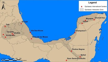
Contemporary views of the nature of these political, economic, and social dynamics have moved away from migration and invasion as explanatory frameworks, focusing instead on new political institutions and ideologies. Ringle and colleagues (Reference Ringle, Negrón and Bey1998) and López Austin and López Luján (Reference López Austin and Luján1999, Reference López Austin, Luján, Carrasco, Jones and Sessions2000) have argued that architectural, artistic, and ceramic links between a network of important centers in the Epiclassic were part of a new world order melding religious and political messages intricately linked to a pan-Mesoamerican religious cult associated with the personage or deity Quetzalcoatl/Kukulcan (Figure 1). The connections between the pilgrimage centers identified by Ringle and colleagues (Reference Ringle, Negrón and Bey1998) and López Austin and López Luján (Reference López Austin and Luján1999, Reference López Austin, Luján, Carrasco, Jones and Sessions2000) are reflected most notably in remarkable architectonic and artistic similarities (Kristan-Graham and Kowalski Reference Kristan-Graham, Kowalski, Kowalski and Kristan-Graham2007; Love Reference Love2012). Freidel (Reference Freidel, Sabloff and Andrews V1986) has stressed the importance of religious syncretism and shared symbols in pan-Mesoamerican trade networks linking the Maya area, highland Mexico, and the Gulf Coast. The spread of this cult likely originated in the Chontalpa region in the ninth century (Dahlin Reference Dahlin2002), with the strongest evidence of participation occurring along riverine waterways and the Gulf Coast (Pohl Reference Pohl, Smith and Berdan2003; Ringle et al. Reference Ringle, Negrón and Bey1998:214). This network included several Epiclassic (a.d. 800–900/1100) and Postclassic (a.d. 900/1100–1500) pilgrimage centers oriented in an arch between central Mexico and the Maya area, connected by the Gulf Coast maritime trade route. Some of the most prominent examples of these pilgrimage centers include Tula, Chichen Itza, Cholula, El Tajín, Xochicalco, Cacaxtla, and Uxmal. The mechanisms and nature of the spread of the cult of the Feathered Serpent are poorly understood, but probably include a high degree of economic, social, and political integration.
Quetzalcoatl cult network as defined by Ringle, Gallareta Negrón, and Bey (adapted from Ringle et al. Reference Ringle, Negrón and Bey1998:Figure 1).

In the Maya area these new developments are most prominent at Chichen Itza, where political, economic, and ideological innovations included new forms of art and architecture. These new visual and symbolic systems are characterized by an eclectic and cosmopolitan mix of symbols with strong foreign elements that reflect linkages with centers in Veracruz and the basin of Mexico (Cobos Palma Reference Cobos Palma, Demarest, Rice and Rice2004; Dahlin Reference Dahlin2002; Krochock Reference Krochock1998; Lincoln Reference Lincoln1991; Love and Kaplan Reference Love and Kaplan2011; Ringle et al. Reference Ringle, Negrón and Bey1998; Wren and Schmidt Reference Wren, Schmidt and Culbert1991). Changes in the role of warfare at Chichen Itza indicate a focus on territorial expansion and the importance of access to coastal trade routes (Cobos Palma Reference Cobos Palma, Demarest, Rice and Rice2004; Dahlin Reference Dahlin2000, Reference Dahlin2002; Freidel and Schele Reference Freidel, Schele, Hanks and Rice1989; Krochock Reference Krochock1998; Lincoln Reference Lincoln1991; Schele and Freidel Reference Schele and Freidel1990; Stuart Reference Stuart, Sabloff and Henderson1993). These innovations would become defining attributes of the Postclassic period across Mesoamerica (Masson et al. Reference Masson, Hare, Lope, Schwartz and Nichols2006; Milbrath and Peraza Lope Reference Milbrath and Lope2003).
The nature of exchange networks also underwent significant change, with a shift from low-bulk, high-value items in the prestige sphere to the movement of bulk goods via maritime trade routes (Andrews Reference Andrews1983, Reference Andrews, Clancy and Harrison1990; Berdan et al. Reference Berdan, Masson, Gasco, Smith, Smith and Berdan2003; Dahlin and Ardren Reference Dahlin, Ardren, Masson and Freidel2002; Ek Reference Ek2008, Reference Ek2009, Reference Ek and Braswell2012; Kepecs et al. Reference Kepecs, Feinman and Boucher1994; Masson and Mock Reference Masson, Mock, Rice, Rice and Demarest2004; West Reference West, Masson and Freidel2002). The increase of trade and religious activity as well as armed conflict in northern Yucatan was associated with radical changes in the geopolitical landscape following the depopulation of Classic-period city-states across the raised karstic plain that extends across much of the southern and central Maya lowlands (Braswell et al. Reference Braswell, Gunn, Domínguez Carrasco, Folan, Fletcher, López, Glascock, Demarest, Rice and Rice2004; Domínguez et al. Reference Domínguez Carrasco, Folan, Gates, Heredia, Gunn, López, Robichaux, Volta, Arroyo, Paiz and Mejía2012; Dunning et al. Reference Dunning, Beach and Luzzadder-Beach2012; Gates Reference Gates, Folan, García Ortega and Sánchez González1992, Reference Gates, Folan, Sánchez González and García Ortega1999; Turner and Sabloff Reference Turner and Sabloff2012). The movement to the coast included a major reorientation of trade routes. Provenience studies of obsidian have demonstrated a notable increase in exchange between the Maya lowlands and central Mexico, which likely focused on the Gulf Coast trade route (Andrews et al. Reference Andrews, Asaro, Michel, Stross and Rivero1989; Braswell Reference Braswell, Smith and Berdan2003). Masson and Mock (Reference Masson, Mock, Rice, Rice and Demarest2004) have argued that shifts to coastal trade routes and decentralization of market systems would have further undermined the power of large inland centers. Braswell and Glasscock (Reference Braswell, Glascock and Glascock2002; see also West Reference West, Masson and Freidel2002) have convincingly shown that changing obsidian exchange systems in the Terminal Classic period at Chichen Itza reflect a transition from a bounded solar market system to an open interlocking market system by a.d. 900 (Smith Reference Smith and Smith1976). These processes were part of a general pan-Mesoamerican pattern of increasing commercialism, interregional exchange, and a general strengthening of linkages between previously disparate parts of Mesoamerica (see Andrews and Sabloff Reference Andrews V., Sabloff, Sabloff and Andrews V1986; Berlo and Diehl Reference Berlo and Diehl1989; Braswell Reference Braswell, Smith and Berdan2003; Reference Braswell2009; Freidel and Sabloff Reference Freidel and Sabloff1984; Masson Reference Masson2000; Masson et al. Reference Masson, Hare, Lope, Schwartz and Nichols2006; Milbrath and Peraza Lope Reference Milbrath and Lope2003; Sabloff and Rathje Reference Sabloff and Rathje1975b; Smith and Berdan Reference Smith and Berdan2003b).
With the emergence of the Gulf Coast as the most prominent trade thoroughfare, the frontier region between the Maya lowlands and central Mexico—including coastal zones of Campeche, Tabasco, and Veracruz—take on much greater pan-Mesoamerican significance in the Terminal Classic/Epiclassic period, with population expansion along coastal and riverine trade routes. A demographic boom took place in southern Veracruz between a.d. 700 and 1000, with a shift from inland settlement to a repopulation of coastal areas (Borenstein Reference Borenstein2005; Killion and Urcid Reference Killion and Urcid2001:19). A similar pattern has been noted in the Maya area at Champotón (Chakan Putun; see Ek and Rosado Ramirez Reference Ek and Ramírez2004; Folan et al. Reference Folan, López, Heredia, Hernández Trujeque, Folan, Forsyth, Blos, Gómez Coba, Cen, Bishop, Bolles, Braswell, Ek, Gunn, Götz, Villanueva, Blanco, Gunam, Domínguez Carrasco, Noble and Palma2012; Forsyth Reference Forsyth and Palma2012), the Chikinchel region (Kepecs Reference Kepecs1999, Reference Kepecs, Smith and Berdan2003), and along the Caribbean coast (Joyce Reference Joyce1991; Masson Reference Masson2000, Reference Masson, Smith and Berdan2003; McKillop Reference McKillop1996). Additional research in the Candelaria River drainage (Vargas Pacheco Reference Vargas Pacheco and Rattray1998, Reference Vargas Pacheco2001) and along a postulated inland trade route across the base of the Yucatan peninsula (Alexander Reference Alexander2000; Alexander and Canché Manzanero Reference Alexander, Canché Manzanero, Rubio and Gubler2005; Chase and Chase Reference Chase and Chase1982; Hammond Reference Hammond1983) indicate that trade became a major factor in site location.
Whether instigated by climatic change, anthropogenic environmental change, or other factors, the movement of interior population centers from urban areas such as Calakmul to coastal redistribution centers such as Chakanputun during the Terminal and Postclassic instigated major changes in political, economic, and social institutions. Our own research in Coba, Calakmul, and Chakanputun (Champotón) support our initial arguments that climatic change played a major role in demographic movements to northern Yucatan and coastal and riverine zones during the Terminal Classic period (Folan et al. Reference Folan, Gunn, Eaton and Patch1983b). These new seats of power were well situated near strategic coastal trade routes that afforded a more efficient form of transportation for goods and people between disparate parts of Mesoamerica.
GOD, MYTH OR KING? QUETZALCOATL/KUKULCAN IN MESOAMERICAN FOLKLORE
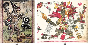
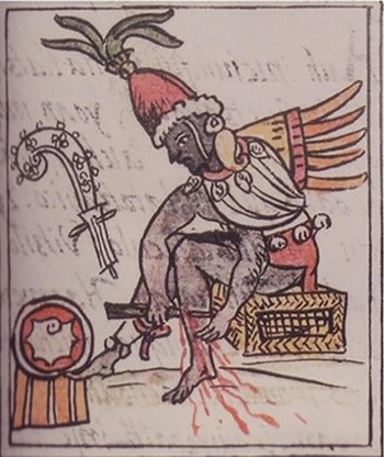
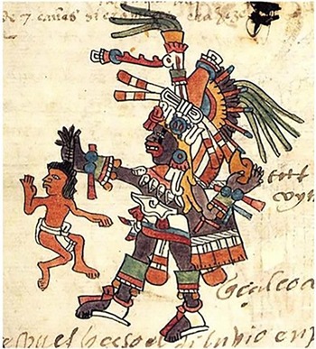
The nature, social meaning, and mythology of Quetzalcoatl/Kukulcan have been a source of considerable debate within Mesoamerican archaeology due to the different aspects of this deity and the multiplicity of phenomena associated with him. In his exhaustive synthesis of ethnohistorical sources on the subject, Nicholson (Reference Nicholson2001) identified two main aspects of the Feathered Serpent: the quasi-historical Toltec ruler Topiltzin Quetzalcoatl and the god Ehecatl Quetzalcoatl (Figures 2–4). Many ethnohistoric sources conflate these two, adding a great deal of confusion to interpretations of the role of this deity in Mesoamerican pantheons as well as in changing political systems and religious movements between the Classic and Postclassic periods.
The multiple aspects of Quetzalcoatl. (a–b): Images of the god Ehecatl Quetzalcoatl (Durán Reference Durán1971 and Nowotny Reference Nowotny1976).

Depiction of ruler Topiltzin Quetzalcoatl performing auto sacrifice from the Florentine Codex (Sahagún Reference Sahagún1969b).

Quetzalcoatl, detail from f. 10 recto (Trecena 3) in Codex Telleriano-Remensis (Quiñones Keber Reference Quiñones Keber1995).

Historical narratives associated with the mythical personage Topiltzin (“our ruler”) Quetzalcoatl describe an individual with the prototypical attributes of ruler, priest, and cultural hero: fundamentally human qualities (Figures 3–4; Florescano Reference Florescano and Hochroth1999; Nicholson Reference Nicholson2001). The deeds and actions associated with Topiltzin Quetzalcoatl range from the mundane to the supernatural, including pilgrimages as a wandering holy man to the mythical founding of cities (Gillespie Reference Gillespie1989; Nicholson Reference Nicholson2001). In his role as sovereign. Quetzalcoatl is depicted as the inventor of many of the prototypical attributes of civilization, including the founding of the first great city of Tollan, and the seed for all subsequent legitimate dynasties. As such Topiltzin Quetzalcoatl serves as a symbol for the pious and just ruler. These characteristics were the basis of idealized rulership and political legitimacy encompassed within the concept of “Toltecoyotl.” This concept would form a central element in political ideologies that linked rulers across Mesoamerica (López Austin and López Luján Reference López Austin, Luján, Carrasco, Jones and Sessions2000).
Migrations and founding of cities and dynasties is a central element of indigenous historical accounts associated with Quetzalcoatl/Kukulcan. Central Mexican historical narratives recount the exile of Quetzalcoatl (“Feathered Serpent” in Nahuatl) from Tollan and exodus to the east via Cholula to the Gulf Coast, in some versions of the narrative continuing east via raft. Parallel sources document the arrival of the mythical personage of Kukulcan (Kukul Can or “Feathered Serpent” in Mayan dialects) in the Yucatan Peninsula from the west. After this arrival, Kukulcan was said to migrate across the Maya area establishing a network of cities (Figure 1; Folan et al. Reference Folan, Bolles and Ek2010; López Austin and López Luján Reference López Austin, Luján, Carrasco, Jones and Sessions2000; Ringle et al. Reference Ringle, Negrón and Bey1998). In early correlations between archaeological and ethnohistorical data, these events have been correlated with archaeological evidence of “Mexican” influence in the Maya area during the Terminal Classic period, particularly in similarities between the cities of Tula and Chichen Itza (Roys Reference Roys1966; Thompson Reference Thompson1970; Tozzer Reference Tozzer1957). Because of the correlations between central Mexican and Maya historical narratives, many invasion models of the Classic to Postclassic transition have focused on the role of Quetzalcoatl/Kukulcan as a real historical personage. A common theme in these historical narratives is the foundation of cities and dynasties along this migration route, with veneration of the Feathered Serpent deity a central element in religious practices and political ideologies.
The other aspect of the Feathered Serpent, Ehecatl Quetzalcoatl, pertains to the realm of the supernatural (Figure 2). Ehecatl Quetzalcoatl was an important deity associated with a range of phenomena, including creation, wind, fertility, rain, the star Venus, merchants, and the arts (López Austin and López Luján Reference López Austin, Luján, Carrasco, Jones and Sessions2000; Taube Reference Taube1992, Reference Taube and Prem1999, Reference Taube and Grube2001). López Austin and López Luján (Reference López Austin, Luján, Carrasco, Jones and Sessions2000:37) argue that the Feathered Serpent combines a diverse set of incongruous symbols, with his body forming the column that supports the sky, and playing a major role in phenomena associated with human gestation, wind, dawn, and Venus. Characteristics that link the deity Ehecatl Quetzlacoatl with Topiltzin Quetzalcoatl include the invention of important elements of “civilized life” or “Toltecoyotl,” such as commerce, calendrics, the priesthood, learning and knowledge, and the temporal order. López Austin and López Luján (Reference López Austin, Luján, Carrasco, Jones and Sessions2000:37–38) condense his many attributes down to a fundamental role as “extractor,” or one who moves substances or knowledge from the realm of the gods to the world of humans, or one who “transcends boundaries.” As noted above, linkage or descent from “Toltec” ancestors were based on this concept, and were a fundamental component of political ideologies in the Epiclassic and Postclassic periods.
This huge diversity of attributes and multiplicity of names and associations has led to a great deal of confusion about the role of this god in Mesoamerican religious, social, and political life. While it is certainly within the realm of possibility that the mythic Topiltzin Quetzalcoatl personage might have been based on an actual historical ruler—either associated with the city of Tula or some other place or polity—this personage was subsequently conflated with the supernatural entity of Ehecatl Quetzalcoatl. The ambiguity in different accounts—ranging from the exclusive realm of gods, to a melding of godlike and human qualities, to mundane roles as wandering pilgrim and priest—leave a great deal of leeway for potential interpretations.
Research focusing on the location of Tollan, the identity of Quetzalcoatl, and the role of this mythical ruler in broader Mesoamerican dynamics has approached the topic from many different perspectives (reviews and critiques include Davies Reference Davies1977; Gillespie Reference Gillespie1989; López Austin Reference López Austin1973; Nicholson Reference Nicholson2001; Ringle et al. Reference Ringle, Negrón and Bey1998; Smith Reference Smith, Kowalski and Kristan-Graham2007). In his ethnohistorical synthesis, Nicholson (Reference Nicholson2001) was credulous about the status of this character as a real historical figure. Others, such as Gillespie (Reference Gillespie1989) and Ringle and colleagues (Reference Ringle, Negrón and Bey1998) argued these accounts are best included in the realm of myth, functioning as an ideological charter for political legitimation during the Late Postclassic and Colonial periods. Gillespie (Reference Gillespie1989) argues that the melding of myth and historical elements in a political narrative took place during the Late Postclassic, likely including the conflation of the Topiltzin and Ehecatl aspects of the Feathered Serpent into single entity. Smith is highly dubious of any attempt to glean historical information from these sources, arguing that use of these histories to understand developments in pre-Hispanic era are misguided (Smith Reference Smith, Kowalski and Kristan-Graham2007). Historiographic studies of Mesoamerican indigenous histories would seem to support this more critical perspective (Gillespie Reference Gillespie, Kowalski and Kristan-Graham2007; Gunsenheimer Reference Gunsenheimer and Prem2003; Kepecs Reference Kepecs1997; Smith Reference Smith, Kowalski and Kristan-Graham2007).
As mentioned above, the increasing prominence of feathered serpent imagery associated with the god Quetzalcoatl/Kukulcan is one of the most important changes in public art and iconography during the Terminal Classic period (Baldwin Reference Baldwin1998; Berlo and Diehl Reference Berlo and Diehl1989; Folan et al. Reference Folan, Bolles and Ek2010; Kowalski and Kristan-Graham Reference Kowalski and Kristan-Graham2007; López Austin and López Luján Reference López Austin and Luján1999, Reference López Austin, Luján, Carrasco, Jones and Sessions2000; Rice Reference Rice1983; Ringle Reference Ringle2004; Ringle et al. Reference Ringle, Negrón and Bey1998). Ringle and colleagues (Reference Ringle, Negrón and Bey1998:233) envision this process as a reconceptualization of the role of this god within Mesoamerican pantheons, including new aspects of Quetzalcoatl as the alligator earth monster cipactli and the association with creation (see also López Austin Reference López Austin1973; López Austin and López Luján Reference López Austin and Luján1999; Thompson Reference Thompson1970). The association with creation that is evident in Aztec creation myths seems to have origins at least as early as the end of the Classic period, as reflected in numerous depictions of humans emerging from the mouth of a feathered serpent. Ringle and colleagues (Reference Ringle, Negrón and Bey1998:188) argue that the conflation of Topiltzin Quetzalcoatl with the god Ehecatl Quetzalcoatl was a symbolic narrative: “…the wandering city-founder Quetzalcoatl is better viewed as a later etiological attempt to explain the spread of his cult, uniting in a single figure several historical episodes probably separated by centuries.”
Indigenous historical accounts link the spread of Feathered Serpent worship with the migrations and movements of various mysterious ethnic groups, including the Olmeca Xicallanca and Tolteca-Chichimeca (López Austin and López Luján Reference López Austin, Luján, Carrasco, Jones and Sessions2000; Ringle et al. Reference Ringle, Negrón and Bey1998). Many of these accounts are associated with the establishment of Cholula as a pilgrimage center devoted to Quetzalcoatl (Durán Reference Durán1971:128–133). An account by Ixtlilxochitl (Reference Ixtlilxochitl1975:528–530) attributes the introduction of Feathered Serpent worship to the arrival at Cholula of the Olmeca Xicallanca, who are said to have arrived by boat from the east prior to the age of the Toltecs. Other sources corroborate the mythical origins of Quetzalcoatl in the east (see Ringle et al. Reference Ringle, Negrón and Bey1998:187). The connection of both the god and personage of Quetzalcoatl/Kukulcan with migration is abundantly clear in art and iconography from across Mesoamerica, ranging from feathered serpents as stages for ritual processions to migration iconography such as “footprint” motifs.
While migration stories are a central theme in oral histories and symbolism associated with Quetzalcoatl/Kukulcan, evaluation of the historical accuracy of these accounts is beset by major historiographical problems. Instead, these myths and stories are part of political narratives reflecting the importance of links between political and religious centers within the context of an emerging new religious movement. Ringle and colleagues (Reference Ringle, Negrón and Bey1998) and López Austin and López Luján (Reference López Austin and Luján1999, Reference López Austin, Luján, Carrasco, Jones and Sessions2000) argue that the spread of feathered serpent imagery within a network of cities along the Gulf Coast reflects the spread of a new political-religious order during the Epiclassic/Terminal Classic period. From this perspective, migration and place-making narratives were central elements in creation myths which lent a genealogical charter to emergent Epiclassic and Terminal Classic elites within the context of the more highly integrated and international political, economic, and ideological systems.
An associated change in religious iconography includes increasing centrality of the deity Ek Chuah (God L). Although less prominent than the Feathered Serpent, Ek Chuah also assumes a more central role in Mesoamerican art and iconography during the Epiclassic period. The importance of God L reaches an apogee slightly earlier (around a.d. 750), appearing in the monumental art centers across Mesoamerica such as Cacaxtla, Chichen Itza, and Cauinal, and in several sites in Campeche, such as Edzna, Dzehkabtún, Sabana Piletas, and Santa Rosa Xtampak (Arnauld Reference Arnauld1990:360; Grube et al. Reference Grube, Gayol and Castillo2009; Martin and Grube Reference Martin and Grube2008:151–152; Pallán Gayol Reference Pallán Gayol2009:99–101; Taube Reference Taube1992:Figure 41b, Reference Taube and Grube2001:272). The early association with this deity at the end of the Classic period—particularly in Campeche—is interesting given the role of this god as the patron deity of merchants and long-distance trade (Pallán Gayol Reference Pallán Gayol2009:99–100; Schellhas Reference Schellhas1904:34–35; Taube Reference Taube1992:90; Thompson Reference Thompson1970:306–308). This correlation makes sense given the well-documented role of Gulf Coast groups in coastal trade. Both Quetzalcoatl/Kukulcan and God L have been associated with Chontal groups or with religious movements between centers on the Gulf Coast (Folan et al. Reference Folan, Bolles and Ek2010; López Austin and López Luján Reference López Austin and Luján1999, Reference López Austin, Luján, Carrasco, Jones and Sessions2000; Pallán Gayol Reference Pallán Gayol2009; Ringle et al. Reference Ringle, Negrón and Bey1998). While the Gulf Coast maritime trade route was likely an important thoroughfare in increasingly integrated pan-Mesoamerican political, economic, and ideological systems of the Epiclassic and Postclassic periods, many of the traits associated with this “new order” have not been extensively documented at centers in the southern and eastern Gulf Coast.
While historiographic studies have demonstrated the shortcomings of uncritical acceptance of indigenous narratives as historically accurate accounts and projection of these sources into the pre-Hispanic era (Gillespie Reference Gillespie, Kowalski and Kristan-Graham2007; Gunsenheimer Reference Gunsenheimer and Prem2003; Smith Reference Smith, Kowalski and Kristan-Graham2007), indigenous histories provide an important window into the role of migration and foundation myths in political narratives late in the pre-Hispanic era. In particular, these mythical narratives reflect important links between polities that transcended political boundaries. Indigenous histories were part of political narrative that linked cities across Mesoamerica through both mythical migrations of the personage/god Quetzalcoatl/Kukulcan. Interpolity links consisted of both actual physical connections and symbolic ties between cities, which were envisioned as celestial, terrestrial, and subterranean links. In addition to the clear evidence for increasing pan-Mesoamerican interaction reflected in material culture, these histories offer important additional information about the nature of the interregional networks of the Epiclassic and Postclassic periods.
POLITICAL INFRASTRUCTURE: PHYSICAL, METAPHORICAL, AND SYMBOLIC
The central thesis of this paper is that the connections between cities that defined political, economic, and social networks were signified by both physical and symbolic linkages. These linkages can be divided into three types of interpolity connections, including both tangible and symbolic “political infrastructure.” Terrestrial roads, or sacbeob (zac beob see Beltran Reference Beltran1859; Ciudad Real Reference Ciudad Real and Acuña2001), consist of raised roads built from masonry, earth, or shell in centers across the Maya lowlands (Bolles Reference Bolles1997–2015; Bolles and Folan Reference Bolles and Folan2001; Bustillos Carrillo Reference Bustillos Carrillo1964; Shaw Reference Shaw2001, Reference Shaw2008; Saville Reference Saville1930:Figures 5–8). The elevated road systems of the lowland Maya are well known archaeologically from the Preclassic period onward (Benavides Castillo Reference Benavides Castillo1981; Bennett Reference Bennett1930; Bolles and Folan Reference Bolles and Folan2001; Folan Reference Folan1977a, Reference Folan1977b; Hanks Reference Hanks1990; Maldonado Cardenas Reference Maldonado Cardenas1979; Normark Reference Normark2006; Shaw Reference Shaw2001, Reference Shaw2008; Stanton Reference Stanton2005; Stanton and Freidel Reference Stanton and Freidel2005; Stuart Reference Stuart2006; Villa Rojas Reference Villa Rojas1934).
Less well understood are links between cities envisioned as celestial roads and mythical underground routes (Sharer and Traxler Reference Sharer and Traxler2006:731). These include the cuxaan zum routes (Tozzer Reference Tozzer1907) at times represented by umbilical cords and the Tamacaz or Milky Way, which is interpreted as a celestial path or road. Celestial avenues, or cuxaan zumoob, are conceptualized as living ropes symbolizing a consanguineous relationship in the form of an umbilical cord (Miller Reference Miller and Hammond1974, Reference Miller1982:91–95; Olton Reference Olton, Blos, Palma and Robinson2002; Tozzer Reference Tozzer1907:133, Figure 9). The cuxaan zum also represents relationships between individuals and by extension, their families and extended households, as depicted on polychrome vessels (Reents-Budet Reference Reents-Budet1994:Figure 19). According to Professor Jose A. Xiu (Miller Reference Miller1982:92) speaking in Mérida, when the cuxaan zum is once again joined together, “[i]t will be strung up like an immense suspension bridge from the turbulent Caribbean sea and this sacred city of Ich canziho,” giving the idea that the cuxaan-zum once stretched from a place such as Tulum on the shores of the Caribbean to Mérida thus resembling descriptions of the sites and cities from Tulum to Coba to Valladolid and westward to Mérida. It is here where they turn south to Mani, Uxmal and Champotón in the form of a subterranean zahcab. These mythical subterranean routes were underground links between cities. These were called zahcab according to oral histories collected by Folan in Chemblas, Campeche (see Bolles and Folan Reference Bolles and Folan2001). The above mentioned tie between Kukulcan and the Coba/Yaxuna sacbe indicates his travels on terrestrial roads (Villacorta Calderon Reference Villacorta Calderon1934) and as we will see, Kukulcan was associated with both terrestrial and subterranean routes before arriving on the peninsula. Villacorta Calderon (Reference Villacorta Calderon1934) also describes accounts in which Kukulcan travelled on the Coba-Yaxuna sacbe. Information from myths and oral histories recorded by Bolles and Folan (Reference Bolles and Folan2001) presented below, in addition to other relevant ethnohistorical data, provide important information about indigenous Maya conceptions of connections between cities that were linked into religious, political, and economic networks as early as the Terminal Classic/Epiclassic period. During our investigations in the ruins of Coba, Quintana Roo between 1972 and 1974 (Folan Reference Folan, Folan, Kintz and Fletcher1983) we made a record and a detailed analysis of more than 30 intersite and intrasite sacbeob (Benavides Castillo Reference Benavides Castillo1976a, Reference Benavides Castillo1976b; Folan et al. Reference Folan, Kintz and Fletcher1983a:Figure 5). Simultaneously, we made an ethnographic record of a celestial sacbe network connecting the sites of Tancah Tulum, Coba, Zac Li (White Hawk, modern Valladolid), Chichen Itza (Cobos Palma Reference Cobos Palma, Sanders, Mastache and Cobean2003; Cobos Palma and Winemiller Reference Cobos Palma and Winemiller2001; Schmidt Reference Schmidt1994), Izamal, (Lincoln Reference Lincoln1980), Dzibilchaltun (Bolles and Folan Reference Bolles and Folan2001; Maldonado Cárdenas Reference Maldonado Cardenas and Pacheco1995; Maldonado Cárdenas et al. Reference Maldonado Cárdenas, Voss, Góngora, Blos, Palma and Robinson2002), Ich Caan Ziho (modern Mérida), and Uxmal based on ethnohistoric and ethnographic efforts (Bolles and Folan Reference Bolles and Folan2001). The sources of these accounts included primary research by Folan in interviews with residents of Coba and analogous sources collected by Tozzer (Reference Tozzer1907) in Valladolid, Yucatan. From Uxmal, the road network continued underground to Chakanputun (modern Champotón) and from there to Mexico (Folan Reference Folan1977a). Below, we outline the nature of these links and their political, social, and symbolic importance in pre-Hispanic Maya society.
These linkages between cities had striking similarities to our own concepts about the political geography of the Yucatan Peninsula. Independently, we created a model of Maya geopolitics with principal regional centers of Coba, Zac Ii, Chichen Itza, Izamal, Ich Caan Ziho, Uxmal and Edzná (Folan Reference Folan1977a, Reference Folan1980b). Each of these regional centers was related to a port on the Caribbean or the Gulf of Mexico and associated intermediary sites, following a model outlined by Hirth (Reference Hirth1978) for highland Mexico. Chakanputun was a regional center and a port located on the Gulf Coast in central Campeche (Ek Reference Ek2009, Reference Ek and Braswell2012; Ek and Cruz Alvarado Reference Ek and Alvarado2010; Folan et al. Reference Folan, López, Rosario Domínguez Carrasco, Gonzalez, Gunn, Folan, Barredo, Hernández Trujeque, Bolles and González Heredia2002, Reference Folan, Folan, Morales, Gonzalez, Blos, Bolles, Ruiz and Gunn2003, Reference Folan, López, Hernández Trujeque, Heredia, Folan, Bolles, Gunn and Domínguez Carrasco2004, Reference Folan, López, Heredia, Hernández Trujeque, Folan, Forsyth, Blos, Gómez Coba, Cen, Bishop, Bolles, Braswell, Ek, Gunn, Götz, Villanueva, Blanco, Gunam, Domínguez Carrasco, Noble and Palma2012). The Chichen Itza/Xuenkal/Isla Cerritos route was hypothesized by Andrews and colleagues (Reference Andrews, Asaro, Michel, Stross and Rivero1989) and Manahan and Ardren (Reference Manahan and Ardren2008), while an Izamal and Dzilam route was suggested by Burgos Villanueva and colleagues (Reference Burgos Villanueva, Reyna, Carrillo and Góngora2009). In the aftermath of the Classic Maya collapse, the Terminal Classic geopolitical landscape consisted of large cities and associated port centers incorporated into the highly integrated and international pan-Mesoamerican social political and economic systems.
MAYA SACBEOB: INTERSITE CAUSEWAY SYSTEMS IN THE MAYA LOWLANDS
The most obvious evidence for links between cities and polities are reflected archaeologically in built roads or sacbeob. There is a large body of literature focusing on the nature and function of sacbe systems in pre-Hispanic Maya polities. In one of the more recent reviews of this literature, Shaw (Reference Shaw2001, Reference Shaw2008) differentiates between “local intrasite” causeways that linked plaza groups within a single urban epicenter, “core–outlier intrasite” roads that linked urban epicenters with minor centers and peripheral communities in the surrounding hinterland, and “intersite” causeways that linked cities together. This latter class of road systems would have had both practical and symbolic importance as components of the political landscape as formal material signifiers of interpolity relationships. She also classifies sacbe systems based on the nature and connectivity of nodes, including radial, solar, and dendritic systems (Shaw Reference Shaw2008). Within these different types of roads there is a great deal of variability in the form and degree of architectural elaboration, ranging from simple dual alignments of stone delimiting a pathway, modest raised roads, to the truly monumental causeways at centers like Coba (Figure 5; see also Chase and Chase Reference Chase and Chase2001; Cobos Palma and Winemiller Reference Cobos Palma and Winemiller2001; Folan et al. Reference Folan, Kintz and Fletcher1983a; Shaw Reference Shaw2001, Reference Shaw2008; Thompson et al. Reference Thompson, Pollock and Charlot1932). Additionally, we have classified sacbeob according to terminology and concepts recorded in dictionaries dating from the sixteenth to eighteenth centuries (Bolles and Folan Reference Bolles and Folan2001), including the Mayan terms noh be for large, long roads, cħibal be for roads associated with specific lineages (such as the recently discovered sacbe in Oxpemul) and buth be which cross low, wet areas (Folan et al. Reference Folan, Bolles and Ek2010, Reference Folan, Domínguez Carrasco, Lòpez, Paredes Gómez, Pleites, Sandoval, Robichaux, Folan, Valle, Magallon and Gunn2011). These terms provide information about emic sociocultural concepts associated with these features of Maya political landscapes.
The sacbe (zac be) systems of Classic Maya cities such as Coba include important termini and distant centers, including the Coba-Yaxuna causeway that extends 100 kms and the 20 km-long Coba-Ixil sacbe (Folan et al. Reference Folan, Folan, Kintz and Fletcher1983).

Pre-Hispanic Maya road systems created physical links both within interpolity regional systems as well as marking the territorial limits of individual polities. Intrasite sacbe systems often form a closed system linking different urban complexes within Classic Maya cities. A closed pattern has been documented at Tikal, where the main sacbe system is triangular in plan and provides access only to the main plazas within the site epicenter. Only the Mendoza sacbe extends beyond the nucleus of the city (Carr and Hazard Reference Carr and Hazard1961). At the site of Oxpemul we documented an example of an isolated and defensive communication system with its entry points located below the epicenter of the city, defended by high points and plateaus in a pattern that differs greatly from the other examples previously mentioned (Barnes et al. Reference Barnes, Heredia and López2009). We have recently documented a linear sacbe 1,250 m in length, 20 m wide and 1 m high that connects the two main plateaus of Oxpemul, linking the two major civic/religious nuclei of the city (Folan et al. Reference Folan, Bolles and Ek2010, Reference Folan, Domínguez Carrasco, Lòpez, Paredes Gómez, Pleites, Sandoval, Robichaux, Folan, Valle, Magallon and Gunn2011).
Other cities were connected in more open systems, with intersite sacbe networks facilitating social, economic, and political links between urban centers. The system of sacbeob in the Petén centers on Calakmul, with terrestrial sacbe extending from urban epicenter and market zone located behind Structure VII (Folan Reference Folan1991–1992; Folan et al. Reference Folan, Gunn, Domínguez Carrasco, Inomata and Houston2001) to El Mirador (Folan et al. Reference Folan, Marcus and Miller1995), which may be a twin city (Figure 6). Intersite sacbe systems have been documented at sites such as Coba (Figure 5), Ichmul, Izamal, Chichen Itza, Ich Caan Ziho, El Mirador, and Caracol. We have classified these road networks within a system different to radial, solar, or dendritic as proposed in the excellent work by Shaw (Reference Shaw2001, Reference Shaw2008) into another based on the symbolic configuration of arteries. In the case of Coba, this system mimics the shape of a “V shaped” funnel formed by its principal sacbeob. This latter pattern reflects an open communication system designed to facilitate the passage of people, ideas and goods (Folan et al. Reference Folan, Hernández, Kintz, Fletcher, Hau and Canche2009), as is the case at Chichen Itza, Calakmul, El Mirador, and Caracol. These terrestrial sacbe systems provide a clear material correlate for interpolity communication routes extending from the Formative through Postclassic period.
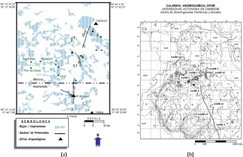
Calakmul combines both (a) internal and (b) intersite systems (adapted from Folan et al. Reference Folan, Gunn, Domínguez Carrasco, Inomata and Houston2001).

CUXAAN ZUMOOB: CELESTIAL LINKS BETWEEN PILGRIMAGE CENTERS
A metaphorical and less tangible form of intersite connections included celestial avenues, or cuxaan zumoob, that symbolized consanguineous relationships between individuals, groups, and places. These links were envisioned as living ropes in the form of an umbilical cord (see Figure 7; Miller Reference Miller and Hammond1974, Reference Miller1982:91–95; Olton Reference Olton, Blos, Palma and Robinson2002; Tozzer Reference Tozzer1907:133). Umbilical cord imagery has been noted in Maya art and iconography—particularly in images on polychrome vessels— as living ropes connecting individuals, families, extended households, and places (Reents-Budet Reference Reents-Budet1994:203).
Images of cuxaan zum as a rope or umbilical cord connecting places and individuals (Villacorta and Villacorta Reference Villacorta and Villacorta1930:218).

Mythical accounts and folklore depict cuxaan zumoob as large blood-filled cords that connected cities (see Appendix B). In one important account, a cuxaan zum was able to support a group of Itza warriors (Bolles and Folan Reference Bolles and Folan2001). In another account, a Spanish military contingent cut the cuxaan zum connecting Coba and Zac Ii, effectively severing communications between these two important cities (Bolles and Folan Reference Bolles and Folan2001; Folan et al. Reference Folan, Kintz and Fletcher1983a). Other celestial links were associated with the Milky Way (Tamacaz [Ciudad Real Reference Ciudad Real and Acuña2001]) that was interpreted as a celestial path or road (Sharer and Traxler Reference Sharer and Traxler2006). While the cuxaan zum stretch from one population center to another, the xibalba be led to the underworld (Villacorta Calderon Reference Villacorta Calderon1934).
ZAHCABOOB: UNDERGROUND NETWORKS
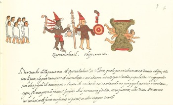
In addition to the terrestrial and celestial links, mythical subterranean routes linked cities via underground passages between cities. These subterranean passageways were called zahcab according to three conversations with José Maria Calan Zuc of Chemblas, Campeche (see Bolles and Folan Reference Bolles and Folan2001). Myths outlining the deeds of Quetzalcoatl/Kukulcan frequently include migrations and founding events in subterranean settings (see Appendix B). In one account, Quetzalcoatl, accompanied by Xipe Totec, built houses under the earth in Mictlancalco (“the house of dead”). In others Quetzalcoatl/Kukulcan excavated a passageway through a mountain that they could not cross (Figure 8; Kingsborough Reference Kingsborough, Aglio, Havell and Bohn1831–Reference Kingsborough, Aglio, Havell and Bohn1848) and another in the form of a tunnel passing beneath the sea (Muñoz Camargo Reference Muñoz Camargo1981:Plate 84v). In the Codex Kingsborough, Quetzalcoatl and Xipe Totec are depicted leading migrants through the underground passageway in a mountain:
“The two lords of penitence, Quetzalcohuatl and Totec, also called Chipe [Xipe], took the children and innocent people that remained [in Tula] and left with them going into the world populating it and taking with them other peoples that they encountered. And they say that, as they were walking with these peoples, they arrived at certain mountains. Being unable to traverse them, they thought up a way to bore underneath them, and so they passed through, others say that they remained stuck there and were transformed into stone and other similar unknown things” (translation by Beniamino Volta from the original Italian text in the Codex Vaticanus 3738A [Ehrle Reference Ehrle1900 (1566):f. 9r]).
Quetzalcoatl and Xipe Totec migrating through the world according to the Codex Vaticanus. In this image, the migrants pass through an underground passageway through a mountain (Kingsborough Reference Kingsborough, Aglio, Havell and Bohn1831–1848).

Subterranean routes were related to the numerous sascaberas in the Yucatan Peninsula, including several very large and long (±300 m) sascaberas in Champotón (Jose A. Hernandez Trujeque, personal communication 2012) and other sascaberas in Mani (Brainerd Reference Brainerd1958; Folan Reference Folan1969a). Compared to the terrestrial and celestial links reviewed above, there are far fewer depictions and iconography associated with subterranean routes. These are discussed by Reents-Budet (Reference Reents-Budet1994:101, 203, n24), who equates caves with sacrificial rites as being entrances to the underworld. Cenotes were associated with similar meanings. These are reasonably comparable to sascaberas and the subterranean zahcab routes between Mérida, Mani, Uxmal and Chakanputun, as well as the obsidian mines in the highlands and the tunneling of mountains associated with Quetzalcoatl/Kukulcan along with his numerous sojourns into the underworld (Carrasco Reference Carrasco2000).
Underground routes were related to religious rites that include human sacrifice of adults and/or children (Folan Reference Folan1970), as exemplified in the underground route between the Cenote X-Lacah in Dzibilchaltun with Chablekal (Marden Reference Marden1959), the route between Mani and Ich Caan Ziho associated with a celestial and underground route, and, apparently, the route linking Acanmul and Uxmal, almost all which are found in the western part of the Yucatan Peninsula. Although we do not know of a mythical or physical link providing access to the Postclassic round observatory at Mayapan, we believe that there is a strong possibility that they may have existed and that myths associated with them are still to be discovered.
Chronologically, the oldest routes appear to be terrestrial sacbeob that are common by the Preclassic period and continued in use and increased in frequency during the Classic and Terminal Classic periods. Not surprisingly, we have far fewer early dates for celestial and underground routes due to the lack of the material correlates identifiable in the archaeological record. Myths concerning subterranean zahcab routes, most frequent in the western part of the Yucatan Peninsula, include clearly late historical elements such as cows, roosters, horses, cats, and other species introduced by Europeans. A similar pattern has been documented in myths concerning underground routes followed by Quetzalcoatl between the Mexican highlands to Coatzalcoalcos as well as his association, in the form of an Ehecatl Quetzalcoatl effigy, with an underground obsidian mine in the highlands of Mexico (Pastrana Reference Pastrana2010).
Based on archaeological, ethnohistoric, and ethnographic data, we propose that migration myths associated with the god/personage of Quetzalcoatl/Kukulcan were part of a political narrative associated with the development of highly integrated political, economic, and religious systems after the close of the Classic period. Linkages between important cities were envisioned as physical connections corresponding to terrestrial, celestial, and underground communication routes based on the mythic migrations of Quetzalcoatl/Kukulcan during the ninth century. These migrations followed a general path extending between Mexico and the Yucatan Peninsula, later returning via the same route (Landa Reference Landa and Tozzer1941).
THE KUKULCAN PILGRIMAGE ROUTE AND INTERSITE LINKAGES IN LATE MAYA PREHISTORY
As noted above, the migrations and trajectory of Quetzalcoatl across Mesoamerica between a.d. 700 and 900 has captured the imagination of many investigators of Mesoamerican cultures (López Austin Reference López Austin1973; López Austin and López Luján Reference López Austin and Luján1999). The role of Quetzalcoatl/Kukulcan in political narratives combining migration myths, foundation events, and the construction of linkages between centers was part of a major reorganization of political, religious, and economic systems across the Yucatan Peninsula and Mesoamerica. Based on synthesis of ethnohistoric and ethnographic accounts and our own analyses of the different types of ancient Maya communication routes over the past 35 years we have developed the following model of Quetzalcoatl/Kukulcan's movements from Chakanputun to Tancah Tulum in the Caribbean and back again to Chakanputun. In the sections below we examine each of these routes in greater detail.
THE INITIAL EXODUS FROM CENTRAL MEXICO
In many sources, the migrations start with Quetzalcoatl's departure (either voluntary or through exile) from central Mexico and journey to the Gulf Coast (see Appendix C). According to Wigberto Jimenez Moreno (personal communication 1956), Quetzalcoatl disembarked on a raft of serpents, perhaps raising anchor near Coatzacoalcos (“the place where serpents are enclosed”) to arrive at Tlilan Tlapallan (“The Place Written in Red”) that may have been a geographical reference to the Maya region. One of the pilgrimage centers—perhaps located in the southwestern coast of the Yucatan Peninsula—was Nonoalco (or Onoalco “Where They Are Mute” [Garibay Kintana Reference Garibay Kintana1940]), possibly located somewhere near the linguistic border between Nahuatl and Maya speakers (Landa Reference Landa and Tozzer1941). After leaving Nonoalco, Quetzalcoatl/Kukulcan would have continued rafting toward the area frequented by Mexica merchants, perhaps making landfall in Potonchan (“House of Stench”), Xicallanco (“Place of Calabash”) and Cochiztlan (“The Rest Place”) (Bolles and Folan Reference Bolles and Folan2001), before arriving at Chakanputun (modern Champotón).
Chakanputun (whose toponym translates as “the savannah of the potters,” or “the potter's savannah,” according to Bolles [Folan et al. Reference Folan, López, Hernández Trujeque, Heredia, Folan, Bolles, Gunn and Domínguez Carrasco2004]) was a port capital and commercial center of great importance on the west coast of the Yucatan Peninsula during the ninth century. Items exchanged through Chakanputun included fine paste ceramics (Bishop et al. Reference Bishop, Blackman, Folan, Forsyth and Sears2006; Ek Reference Ek and Braswell2012; Ek and Cruz Alvarado Reference Ek and Alvarado2010; Ek and Rosado Ramírez Reference Ek and Ramírez2005; Forsyth and Jordan Reference Forsyth and Jordan2003), obsidian (Geoffrey Braswell, personal communication 2006, 2010; Folan et al. Reference Folan, López, Heredia, Hernández Trujeque, Folan, Forsyth, Blos, Gómez Coba, Cen, Bishop, Bolles, Braswell, Ek, Gunn, Götz, Villanueva, Blanco, Gunam, Domínguez Carrasco, Noble and Palma2012), and terrestrial and marine food resources (Folan et al. Reference Folan, López, Hernández Trujeque, Heredia, Folan, Bolles, Gunn and Domínguez Carrasco2004; Götz Reference Götz and Palma2012; Piña Chan Reference Piña Chan, Lee and Navarrete1978; Villanueva Garcia Reference Villanueva García2013). Chakanputun also is a place with a great deal of archaeological evidence of cultural influence from highland Mexico and Veracruz, such as mortuary practices associated with the god Xipe Totec (Gómez Coba and Folan Reference Gómez Coba and Folan2007; Hurtado Cen et al. Reference Hurtado Cen, Bastida, Tiesler, Folan, Tiesler and Cucina2002).
Indigenous histories recorded by Spanish chroniclers in both the Maya lowlands and central Mexico focus on the migrations of Quetzalcoatl/Kukulcan from his homeland in central Mexico to Chakanputun via the sea, the founding of Chakanputun, and his subsequent departure from the same port via the sea. Landa (Reference Landa and Tozzer1941:26, ff. 5r–5v) recounted a later migration myth associated with the personage/deity of Kukulcan:
Que este Cuculcan viuio con los señores algunos años en aquella ciudad (Mayapan) y q[ue] dexando losen mucha paz, y amistad se torno por el mismo camino a Mexico, y que de pasada se detuvo en Champoton y que para memoria suya y de su partida hizo dentro en la mar /5v/ vn buen edificio al modo del de Chiçeniza vn gran tiro de piedra de la ribera, y que assi dexó Cuculcan en Yucatan perpetua memoria.
This Kukulcan lived with the lords in that city for several years; and leaving them in great peace and friendship, he returned by the same way to Mexico, and on the way he stopped at Champoton, and, in memory of him and of his departure, he erected a fine building in the sea like that of Chichen Itza, a long stone's throw from the shore. And thus Kukulcan left a perpetual remembrance in Yucatan (translation by Tozzer).
A small island located just off the coast, adjacent to the mouth of the Río Champotón, is very likely the same temple (see also Ruz Lhullier Reference Ruz Lhuillier1969:36; Scholes and Roys Reference Scholes and Roys1968:3). From these mythical accounts, Chakanputun was a launching point for a series of migrations, pilgrimages, and perhaps conquests into the Yucatan Peninsula.
THE CHAKANPUTUN/TULUM ROUTE
From Chakanputun, oral histories and myths trace the movements of Quetzalcoatl/Kukulcan to Tancah Tulum in the Caribbean, beginning his migration between Chakanputun and Uxmal via an underground zahcab (Figure 9; Bolles and Folan Reference Bolles and Folan2001). From there, Quetzalcoatl/Kukulcan continued on to Campeche after leaving Chakanputun, where the Spaniards described a building with an enormous stone serpent swallowing a lion in 1517 (Díaz de Castillo Reference Díaz de Castillo1904). Afterwards he arrived at Acanmul, where there exists a myth, recorded in an account by Calan Zuc (Bolles and Folan Reference Bolles and Folan2001), of an underground passage associated with Quetzalcoatl/Kukulcan between this center leading to Uxmal (Bolles and Folan Reference Bolles and Folan2001). The former center flourished during the Late and Terminal Classic periods (Ball and Taschek Reference Ball and Taschek2015; Ojeda Mas Reference Ojeda Mas, Rubio and Gubler2006, Reference Ojeda Mas2007; Ojeda Mas and Sanchez Reference Ojeda Mas and Sánchez2001; Williams-Beck et al. Reference Williams-Beck, Taschek and Ball2005). Myths also describe a celestial sacbe or cuxaan zum linking Uxmal and Ich Caan Ziho (Bolles and Folan Reference Bolles and Folan2001). Furthermore, there are myths of both an underground and celestial route between Mani and Ich Caan Ziho (Brainerd Reference Brainerd1958; Folan Reference Folan1969b) with the former associated with a temple dedicated to Kukulcan, the sacrifice of infants, and the distribution of water by Ix-Nuc Mani (“Old Woman of Mani”), the mother of the Dwarf of Uxmal (Appendix D; Burns Reference Burns1983; Stephens Reference Stephens1962, Reference Stephens1963). Other underground routes supposedly linked Noh Cacab (a large village in Santa Elena, Yucatan to the Spanish-speaking world; Ciudad Real Reference Ciudad Real and Acuña2001) and Uxmal (Bustillos Carrillo Reference Bustillos Carrillo1964; Dunning Reference Dunning1992; Dunning and Kowalski Reference Dunning and Kowalski1994), as well as the route recorded by David Bolles between Noh Cacab and Ich Caan Ziho. The cenote at the ruins of X-Koch (see Ciudad Real Reference Ciudad Real and Acuña2001; Smyth and Ortega Zapata Reference Smyth and Zapata2008), located between Uxmal and Noh Cacab is connected with Mani by another underground route, thus making Mani perhaps the nexus of the underground zahcab from Uxmal, X-Koch, and Noh Cacab on the way to Ich Caan Ziho.
Celestial, subterranean, and terrestrial routes followed by Quetzalcoatl/Kukul Can between Champoton and Tulum. Drawing by J.J. Cosgaya.

From Ich Caan Ziho to Chichen Itza with its manifold sacbeob (Cobos Palma and Winemiller Reference Cobos Palma and Winemiller2001; Shaw Reference Shaw2008), Quetzalcoatl/Kukulcan continued on to Izamal as indicated in the myth of a cuxaan zum between these two centers (Folan et al. Reference Folan, Kintz and Fletcher1983a). The cuxaan zum between Dzibilchaltun (Chable) with its feathered serpent sculpture (Maldonado Cardenas and Echeverria Castillo Reference Maldonado Cárdenas and Castillo2011)—also known as Ich Caan Ziho according to Maldonado Cardenas (Reference Maldonado Cardenas and Pacheco1995)—and Izamal. This corresponds precisely with the modern route taken by the Purisima Virgin de la Concepcion Inmaculada from the cenote in the principal plaza of the former site to Izamal where she is believed reside to the present day (Bolles and Folan Reference Bolles and Folan2001; Marden Reference Marden1959). The route continued along another cuxaan zum between Izamal, Chichen Itza (Relaciones de Yucatán 1967:270) and Zac Li (Valladolid) according to the same myth compiled in the ruins of Coba, Quintana Roo (Folan et al. Reference Folan, Kintz and Fletcher1983a). This celestial sacbe runs parallel to the 99 km long sacbe between Yaxuna and Coba and the Coba-Ixil sacbe (Benavides Castillo Reference Benavides Castillo1976a, Reference Benavides Castillo1976b; Folan Reference Folan1977b) with the former sacbe also being linked with Kukulcan in indigenous mythology (Villa Rojas Reference Villa Rojas1934).
In Valladolid, with its mythological sacred tree (Tozzer Reference Tozzer1907; Villacorta and Villacorta Reference Villacorta and Villacorta1930), the route continues via another cuxaan zum to Coba. Architecture at the latter site includes a substantial round temple generally associated with veneration of the god Ehecatl Quetzalcoatl in addition to the Kukican terminus of Sacbe #8. From there, Kukulcan continued on to Tulum Tancah along another cuxaan zum supposedly constructed by the Itza (Folan Reference Folan1977b). There are several representations of Quetzalcoatl/Kukulcan at Tulum Tancah as the star of Venus, according to Miller (Reference Miller1982), as well as the goddess Ix Zac Beliz pictured on what may be a sacbe (Sabloff and Rathje Reference Sabloff and Rathje1975a, Reference Sabloff and Rathje1975b). Interestingly, analysis of dental morphology of burial samples between the sites of Chakanputun (Champotón) and Tulum reflect direct relations between these two populations (Cucina and Tiesler Reference Cucina and Tiesler2008). Already established in Tulum Tancah, the expansion of the network associated with Kukulcan may have extended into Central America. This expansion to the south could have followed the sacbe at Tulum Tancah southward as registered by Cogolludo (Reference Cogolludo1971[1842]) and Vapnarsky (Reference Vapnarsky1995), passing by what would come to be the home of the Talking Cross of Chan Santa Cruz (Dumond Reference Dumond2005; Dumond and Folan Reference Dumond, Folan, Hostettler and Restall2001).
THE RETURN THROUGH CHAKANPUTUN TO MEXICO
Already having extended his politico-religious powers and trade routes across much of Yucatan, Quetzalcoatl/Kukulcan then began his return “along the same route to Mexico” (Landa Reference Landa and Tozzer1941), following the celestial cuxaan zum between Tulum Tancah and Coba and continuing on to Chakanputun (Figure 10). More recent myths suggest that this cuxaan zum remained intact until the contact period, when a mounted army cut the cord between Coba and Zac Ii (Bolles and Folan Reference Bolles and Folan2001; Folan et al. Reference Folan, Kintz and Fletcher1983a), thus terminating the link between these two centers. Another possible route led along the sacbe between Coba and Yaxuna to Zac Ii and Chichen Itza, where, according to a myth, Quetzalcoatl/Kukulcan continued on to Mexico by means of an underground passage leading from the Sacred Cenote (Folan Reference Folan1977a, Reference Folan1980a), possibly related to an underground passage extending from beneath the Temple of Kukulcan to the Cenote Xtoloc, with a deviation to the west at the ball court (Folan Reference Folan1980a, Reference Folan1980b) where he could have continued to Chakanputun (Roys Reference Roys1933). In an alternative route to Chakanputun, Quetzalcoatl/Kukulcan travelled from Chichen Itza to Izamal (Relaciones de Yucatán 1967:270) with a mention of Kukulcan listed on a stela from Dzilam (Alexander Voss, personal communication 2009).
After conquering Chichen Itza in the personage of Hunac Ceel, Kukulcan (see Landa Reference Landa and Tozzer1941:22, n123) apparently continued to Mayapán, perhaps with the Itzaes, during his entrance to the peninsula from Cozumel/Ppole (Hernández de Cordova Reference Hernández de Cordova and Seville1921; Ringle et al. Reference Ringle, Negrón and Bey1998) and took control of a large part of the Yucatan Peninsula. Leaving Mayápan, Quetzalcoatl/Kukulcan could have taken the cuxaan zum to Ich Caan Ziho and Motul (Relaciones de Yucatán 1967:77), and from Ich Caan Ziho to Uxmal where the anthropomorphic heads within several mosaics bear iconographic links to Kukulcan (Roman Piña Chan, personal communication 1960; Dunning and Kowalski Reference Dunning and Kowalski1994). His trip later continued south along a masonry sacbe between Noh'pat, Uxmal, and Kabah (Carrasco Vargas Reference Carrasco Vargas, de León and Parvamon1993; Kurjack and Garza Terrazona Reference Kurjack, Terrazona and Ashmore1981; Victor Segovia Pinto, personal communication 1962) and the underground zahcab linking Uxmal to Chakanputun. At Chakanputun, ethnohistoric sources indicate that the people paid tribute to Kukulcan before he embarked on his return to Mexico by sea, erecting in his memory a temple and monument on an island similar to those documented on the east coast of the Yucatan Peninsula (Ruz Lhuillier Reference Ruz Lhuillier1969; Shook Reference Shook1951).
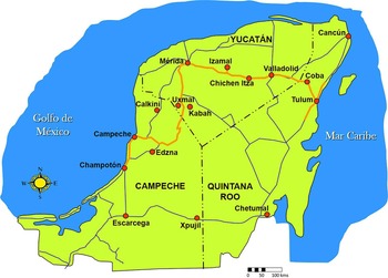
From Chakanputun, Quetzalcoatl/Kukulcan embarked on his return journey to Mexico, following the maritime route via Cuchiztlan, Potonchan, Nonohualco, and Coatzacoalcos, probably personified there as the star Venus before reappearing within the Mexica Empire as the god Quetzalcoatl. In Tenochtitlan, Quetzalcoatl was venerated by the round temple located opposite the Temple of Huitzilopochtli in the sacred precinct of the city (Carrasco Reference Carrasco2000). This latter city was later visited and conquered by Cortez, who followed much of the same route of Quetzalcoatl/Kukulcan outlined above from the coast of the Yucatan Peninsula to Tenochtitlan via Cholula. Later, the conquest of the Yucatan Peninsula by the Montejos in the sixteenth century also includes Chichen Itza and perhaps Coba in the first stage and a second stage disembarking at Chakanputun and continuing on via Calkiní to arrive at Ich Caan Ziho where they established the European regional center today referred to as Mérida. Today the modern highways between Chakanputun, Uxmal, Ich Caan Ziho, Chichen Itza, Izamal, Zac Ii, Coba and Tulum follow the same routes some 1,000 years later (Figure 11). Plans to construct a rapid transit train will follow this same route, linking Champotón, Palenque, Uxmal, Ich Caan Ziho, Izamal, Valladolid, Chichen Itza, Coba and Punta Venado on the east coast of Quintana Roo.
Celestial, subterranean, and terrestrial routes followed by Quetzalcoatl/Kukul Can between Tulum, Champoton, and Coatzacoalcos. Drawing by J.J. Cosgaya.

The modern highway system of the Yucatan Peninsula from Champoton to Tulum. These thoroughfares follow earlier routes taken by Montejo in the Contact period and the earlier mythical routes of Quetzalcoatl/Kukul Can outlined in this work. Drawing by J.J. Cosgaya.

DISCUSSION
Based on the prominence of Quetzalcoatl/Kukulcan in both pre-Hispanic iconography and Contact period indigenous oral histories outlined above, it is clear that this god/personage had great importance in political ideologies by the Terminal Classic period. It is possible that the mythical story of Quetzalcoatl/Kukulcan was, at some point, based on a historical individual but the historiographical issues inherent in projecting oral histories centuries into the past makes interpretations of these sources as historically accurate accounts untenable. An alternative possibility is that actual historical personages undertook pilgrimages and military campaigns as representations of (or within the guise of) Quetzalcoatl/Kukulcan, which could help explain the long history of these myths starting in the Epiclassic period. Unfortunately, evaluating these possibilities is impractical through archaeological methods. Regardless, it is clear that stories concerning the movements of Quetzalcoatl/Kukulcan across Mesoamerica were an important component in the spread of new political and religious concepts that occurred within the context of increasing internationalism, economic integration, and pan-Mesoamerican trade that characterize the Epiclassic/Terminal Classic and Postclassic periods (Ringle et al. Reference Ringle, Negrón and Bey1998). This trend was part of a major change in political ideologies in which the fundamental basis of political legitimacy was reorganized into a new narrative that connected rulers across Mesoamerica into a type of fictive genealogy of power (López Austin Reference López Austin1973; López Austin and López Luján Reference López Austin and Luján1999, Reference López Austin, Luján, Carrasco, Jones and Sessions2000). In this new geopolitical landscape, the establishment of cities—and links between cities—was a crucial element in this new cosmopolitan and “international” system. This geopolitical system materialized as a distinctive urban tradition, exemplified in the new types of urban landscapes that spread across Mesoamerica in the Epiclassic/Terminal Classic period.
As archetypal symbols of just and effective rulership, mythical accounts of the migrations and deeds of Quetzalcoatl/Kukulcan played a central role in emergent links between rulers across disparate parts of Mesoamerica beginning as early as the Late Classic period and intensifying in the Epiclassic/Terminal Classic and Postclassic periods. In these political narratives, Quetzalcoalt/Kukulcan was the source and purveyor of Toltecoyotl: just, enlightened, and pious leadership. While these pan-Mesoamerican political, social, and economic reorganizations are still poorly understood, the oral histories and myths outlined above were undoubtedly a form of political rhetoric linking rulers across Mesoamerica through fictive descent from common ancestors. As we have argued above, this rhetorical focus on the descent of contemporary rulers from the original “Toltec” ancestor as a central element of political legitimacy would last for several centuries.
The spread of this new political and ideological order can be traced in the strong links in monumental art, architecture, and iconography among a network of cities across Mesoamerica. Andrews (Reference Andrews1975:21, 93) has proposed that the great urban centers of the Maya lowlands would be distributed along important routes of interregional communication, and that the internal structure of cities would conform to the trajectory of circulation routes embodied within internal causeway systems (or sacbeob). In addition to trade relationships, the distribution of major cities of the Yucatan Peninsula after the end of the Classic period was also influenced by spatial proximity to maritime and riverine communication routes, sources of potable water, and fertile land. Interregional communication networks were determined by spatial relationships between cities, the emergence of international religious movements, and the kinship, economic, and political relationships that existed between states across Mesoamerica. Most of these cities were located within 50 kilometers of the coastal margin, following the important maritime trade networks that connected many cities into a pan-Mesoamerican interaction sphere that became increasingly important after the end of the Classic period (Andrews Reference Andrews, Clancy and Harrison1990; Folan et al. Reference Folan, Kintz and Fletcher1983a; Freidel Reference Freidel, Chase and Rice1985, Reference Freidel, Sabloff and Andrews V1986; Freidel and Sabloff Reference Freidel and Sabloff1984; Freidel and Scarborough Reference Freidel, Scarborough, Macleod and Wasserstrom1982; Ringle et al. Reference Ringle, Negrón and Bey1998; Sabloff Reference Sabloff and Benson1977; Sabloff and Rathje Reference Sabloff and Rathje1975a, Reference Sabloff and Rathje1975b; Smith Reference Smith, Kowalski and Kristan-Graham2007; Smith and Heath-Smith Reference Smith and Heath-Smith1980; Smith and Berdan Reference Smith and Berdan2000, Reference Smith, Berdan, Smith and Berdan2003a, Reference Smith, Berdan, Smith and Berdan2003c). Although long-distance exchange and interaction has roots no later than the Middle Formative, by the end of the Late Classic period participation in these pan-Mesoamerican networks would have increasingly clear political, economic, and social ramifications. These mythical accounts linked important participant cities in the Postclassic Mesoamerican world through a shared political rhetoric combining migration stories, founding events, and archetypes of political leadership centering on the personage and deity of Quetzalcoatl/Kukulcan.
The highly integrated political, economic, and social networks of the Postclassic were associated with maritime trade networks and three different types of interpolity linkages or routes. This “political infrastructure” included terrestrial sacbe, celestial cuxaan zum, and subterranean zahcab routes. The more common and archaeologically notable of these, the terrestrial sacbeob, apparently played an important role in the development of social, political, and economic integration both within cities and between centers. All three types reflect increasingly important links between centers that developed during the Terminal Classic period in the Maya lowlands. Intersite terrestrial sacbeob serve to reinforce social, political, economic, and religious relations within regional centers with Coba, Chichen Itza, Izamal, Ich Caan Ziho, Uxmal, and Yo'okop, marking not only consanguine relations between lords (cħibal be) but also sacred and secular links between central places and outlying communities.
These ethnohistoric sources provide complementary and corroborating information to the archaeological data outlined by Ringle et al. (Reference Ringle, Negrón and Bey1998) and López Austin and López Luján (Reference López Austin, Luján, Carrasco, Jones and Sessions2000) concerning the role of the god/personage of Quetzalcoatl/Kukulcan in historical developments within the Yucatan Peninsula. While it is impossible to verify if Kukulcan was an historical individual, a mythical amalgamation of several individuals, or a deity, the social importance of Quetzalcoatl/Kukulcan within Mesoamerican cultural developments is abundantly evident by the Terminal Classic/Epiclassic period. While this network has clear economic aspects, we argue that these dynamics also held political significance, reflecting a process through which inter-elite political ideologies were fused across previously disparate Mesoamerican culture areas. This new “genealogy of power” was encoded in political rhetoric focusing on Quetzalcoatl/Kukulcan as the root of political legitimacy. The mythical accounts outlined above reflect the mythical political infrastructure associated with this new world order. The social importance of these linkages is clearly reflected in the continuity of oral histories relating to Kukulcan that are still kept alive in the cultural memory of modern Maya across the Yucatan Peninsula.
CONCLUSIONS
It seems difficult to imagine that diverse modern Maya communities could retain oral histories and memories related to mythical or real routes after 500 to 1000 years. Nevertheless, in the case of the terrestrial, celestial, and subterranean routes associated with the personage of Quetzalcoatl/Kukulcan, there is a great deal of consistency and continuity in mythical accounts in dispersed places such as Chakanputun, Chemblás, Mani, Chichen Itza, Coba, Cozumel, Mayapán, Uxmal and Tulum. Associations with terrestrial, celestial, or underground links between cities, specific temples and buildings, sacbe termini, hieroglyphic texts, or iconography, the information communicated by archaeology, oral histories, and ethnohistories all reflect the importance of Kukulcan within a network of important centers during the Terminal Classic and Postclassic period. This phenomenon was most likely part of a generalized pattern of international ties that spread across Mesoamerica beginning in the Epiclassic period, with shared cultural patrimony, religious syncretism, and common symbolism across disparate areas of Mesoamerica facilitating much greater social and economic integration.
There are many unresolved issues concerning the precise function of the terrestrial zac beob that are so common in archaeological sites across the Maya area and whether these features functioned similarly to the more ephemeral and mythical cuxaan zum and subterranean zahcab routes. In the case of terrestrial zac beob, they likely served multiple social functions, including the demonstration of the power of a ruler and the state, physical manifestations of political links between centers (such as the sacbe systems in the Puuc Hills, and at Izamal, and Coba), a means of organizing movements of people in religious and ritual processions, and as infrastructure for everyday movements of people and goods within cities, between urban centers and peripheral areas, and between polities in inter-polity economic networks (Folan et al. Reference Folan, Hernández, Kintz, Fletcher, Hau and Canche2009). The construction of causeway systems would have provided a durable physical symbol of the power of centralized rulership, showing that nothing was outside the reach of the king, while also facilitating maintenance of geopolitical boundaries, as reflected most clearly in the case of Coba and the distant centers of Ixil and Yaxuna. Generally, terrestrial, celestial and underground routes between pre-Hispanic cities formed symbolic linkages between members of ruling lineages, avenues for commerce, as well as pathways for religious and ritual relations and defensive mechanisms. These linkages were, and continue to be, important symbols of the development of the image of sociopolitical and economic entities, including governors, citizens, and their general well-being, as well as repositories of ancient myths.
RESUMEN
Este trabajo examina los mitos etnohistóricos e históricos orales acumulados durante los últimos 50 años en referencia a los movimientos del personaje mítico de Quetzalcoatl/Kukulcan sobre rutas terrestiales, celestiales y subterráneos a través de las tierras bajas de los mayas después de su llegada a la península de Yucatán. Los datos etnográficos y etnohistóricos incluyen una gran cantidad de información pertinente a conexiones entre importantes centros políticos y económicos, además de centros rituales entre el clásico terminal y posclásico para continuar después de la llegada de los españoles. Estos mitos e historias orales completan los datos arqueológicos reflejando así un aumento en el internacionalismo, integración económica y la posible extensión de movimientos religiosos durante el clásico terminal o epiclásico a través de Mesoamérica.
ACKNOWLEDGMENTS
This paper is an expanded and translated version of a paper titled “Quetzalcoatl/Kukul Can: Su ruta comercial and conquista a través de la Península de Yucatán del siglo IX al XVI en adelante: Una interpretación emica and ética de comunicaciones mesoamericanos regionales and locales,” translated by Jerald Ek and originally presented by William J. Folan, David Bolles and Jerald Ek at the XIX Encuentro de Investigadores de la Cultura Maya en la Univ. Autónoma de Campeche in November 2009. The senior author wishes to thank Jacinto May Hau, Nicolas Caamal Canche, George E. Stuart, Laraine A. Fletcher, Ellen R. Kintz and Lynda Florey Folan for their collaboration and dedication related to Coba, Don José María Calan Zuc for the Acanmul/Uxmal route and José Antonio Hernandez Trujeque on the Chakanputun sascaberas and sacbe. The authors also wish to thank Lynda Florey Folan for her contribution toward the betterment of the manuscript and Marie Carmen Villegas Pascale for calling our attention to several references to Kukulcan in Las Relaciones de Yucatan.
APPENDIX A
References to the various Franciscan vocabularies and other vocabulary sources are given as code letters. These sources cited here are as follows:
- BMTV
-
Bocabulario de Maya Than de Viena (Acuña Reference Acuña1993)
- CMM
-
Motul Mayan-Spanish (Calepino Maya de Motul, Ciudad Real Reference Ciudad Real and Acuña2001)
- DBM
-
Bolles's (Reference Bolles1997–2015) entries
- DMM
-
Combined Solana (ca. 1580) / Diccionario de Motul II (ca. 1580) / S.F. Spanish-Mayan
- NEM
-
Barrera's Nomenclatura Etnobotanica Maya, Mayan-Spanish (Barrera Marin et al. Reference Barrera Marìn, Vásquez and Franco López1976)
APPENDIX B
GLOSSARY OF PROPER NAMES, PLACE NAMES AND OTHER NATIVE MESOAMERICAN WORDS
Belize/Beel Itza: There can be two interpretations of the meaning of the name Belize. If we take into account the Spanish pronunciation of the name then perhaps it is derived from Beel Itza, from beel = “road” and Itza = the tribal name. The other possibility is that the name is derived from the word beeliz: “[b]eeliz: caminante de a pie y cosa que se anda por tierra y ba por tierra” (CMM, Ciudad Real Reference Ciudad Real and Acuña2001). However, in this case one has to wonder why the third syllable “ce” is pronounced in Spanish.
Cacaxtla: “Place of the Backpack Pack,” from cacaxtli = backpack rack and –tla = place. Alternatively, Molina (Reference Molina1970:279) adds that Cacaxtli is the name of a “certain bird” although a search for other sources for this name as a bird has not been fruitful: “[c]acaxtli. escalerillas de tablas para lleuar algo acuestas el tameme, o cierto paxaro.”
Calak Muul: The name Calakmul is derived from the Mayan name Calak Muul = “Paired Man-made Mounds.” This place name is composed of two parts: calak which means “paired” and muul which means “man-made mound / hill.” For an example of the use of calak see: “[c]alak kuch: hilo doblado” (CMM, Ciudad Real Reference Ciudad Real and Acuña2001). For the meaning of muul see NEM: “Mul: Cerro, montículo, montículo arqueológico” (Barrera Marìn et al. Reference Barrera Marìn, Vásquez and Franco López1976). It might be worth mentioning that epigraphers have seized upon the word uitz or huitz for the hieroglyph which represents a pyramid, T685. In the modern language uitz means specifically a natural hill as opposed to muul, which means a man-made hill. Whether this distinction was made back when the hieroglyph was used is something open to question.
Calkini: As a possibility see: “[c]al kin: encalmamiento con sol” (CMM, Ciudad Real Reference Ciudad Real and Acuña2001).
Chac Mool: “Red Claw,” from chac = “red” and mool = “claw.” See also DMM: “[p]ies y manos del tigre: mool; ox.”
Chakan Putun: “Potter's Savannah,” from chakan = savannah and putun, a variant of patom / potom = potter. The Mayan name for the present-day Champoton. See CMM: “[c]hakan: çauana o deesa, vega o campo llano, o heruaje para pasto. / Patom: ollero o alfarero en general; official de cosas de barro. / Potom; potomal: en lo de Mani y Ti Kax; lo mismo que patom, patomal” (Ciudad Real Reference Ciudad Real and Acuña2001).
Chi Cħeen Itza: Following Mayan Colonial Orthography this place name should be spelled as shown, from Chi = “mouth, edge,” Cħeen = “well” and Itza, the tribal group. See CMM: “[c]hij: la orilla o ribera de mar o rio o orilla de heredad, boca de pozo, la margen de la escritura o de papel escrito, de la halda de la vestidura o ropa. / Cħeen: pozo o cisterna o cueua de agua” (Ciudad Real Reference Ciudad Real and Acuña2001). As a side note, the name for Chi Cħeen Itza appears 14 times in Landa's (Reference Landa and Tozzer1941) Relación, usually spelled Chicheniza, but also once as Chiçeniza and once as Chichenyza. Just as in the case of Chi Cħeen Itza, it appears that many of the spelling practices for place names in Yucatan originate with Landa and do not correctly reflect the way the place name should be spelled according to the texts written by the Maya.
Chikin Cheel / Chikin Cħel: “The Western Cheel.” Given that the location of Chikin Cheel is in northeastern Yucatan, it is rather surprising that the region should be called Chikin Cheel. Perhaps this is due to migration. It might also be mentioned that there is the family name Cħel, so it is not certain if this spelling is correct or whether it should actually be Chikin Cħel. Chel is a type of jay bird and Cheel is, among other things, means rainbow.
Cholula: “Place of the Refugees.” See “[c]holollan - top. de una famosa ciudad en la región del actual Puebla” (Garibay Kintana Reference Garibay Kintana1940:303). Lugar de refugiados de Choloa.
Chontalpa: “Place of the foriegners.” See Molina (Reference Molina1970): “[c]hontalli. estrangero o forastero., and Pa. es preposicion, la qual siempre se pospone a los nombres, en esta lẽgua y quiere dezir, en.”
Coatzaqualco: Coatzaqualco, according to the Siméon (Reference Siméon1977:115) dictionary, means “Place Where the Snakes Are Enclosed,” from coatl = “snake,” tzaqua = “enclosed, detained,” and co = “place.” Perhaps this is relevant to the idea that Quetzalcoatl made a raft of snakes and sailed to the east.
Coba: There are a couple of possible meanings for the word Coba. See CMM: “[c]oba: especie de los faisanes llamados bach” (Ciudad Real Reference Ciudad Real and Acuña2001). Also: “[l]ago o laguna de agua: koba .l. hoc akal” (BMTV, Acuña Reference Acuña1993). Given the natural environment surrounding Coba, it would appear that in fact the name should be spelled Koba and not Coba, but the Mayan texts are consistant in using the word Coba so it would seem that the first meaning is the correct one.
Cochiztlan / Cuchiztlan: Cochiztlan is derived from cochi = “sleep, rest” and -tlan = “place.” Cochiztli = “deep sleep.” See the paper “Puerto de Champoton” which has the following quote: "de que los mexicanos lo llamaban la ‘Provincia de Cochistlán' a toda la región comprendida por Champotón que fue definido como significativo de 'lugar hediondo' tal vez por la gran cantidad de restos de pescado y marisco que debían haber sido abandonado en la playa y alrededor del templo en el mar.” That is, Scholes and Roys (Reference Scholes and Roys1968:34) surmise that Cochiztlan might be either Champoton or Campeche, although here they are talking about provinces rather than towns of these names.
Cuxaan Zum: = “Living Rope.” See lines 6–8 of the narrative in Appendix B for a description of one such rope at Mani. See also Tozzer (Reference Tozzer1907:153): “[i]t was at this period (meaning the period of the first creation) that there was a road suspended in the sky, stretching from Tuloom and Coba to Chichen Itza and Uxmal. This pathway was called kušansum or săbke (sic) (white road). It was in the nature of a large rope (sum) supposed to be living (kušan) and in the middle flowed blood. It was by this rope that the food was sent to the ancient rulers who lived in the structures now in ruins. For some reason this rope was cut, the blood flowed out, and the rope vanished forever.”
Ehecatl Quetzal Coatl: “Air/Wind Quetzal Coatl.” One of the aspects of the god Quetzalcoatl.
Hunac Ceel: This name translates as “Uniquely Cold,” meaning very cold-blooded. In the semi-historical narratives of Yucatan there are various personages who lived a historically impossible length of time, and are thus assumed to have been people who had taken on names of deified heroes. One such name is Hunac Ceel.
Itza: An ethnic group of Maya, perhaps speaking a somewhat different dialect from those Maya which are refer to as Yucatec, although studies by Schumann (Reference Schumann G.1971) show a very close relationship between the Itza dialect as spoken around the lake of Peten and Yucatec. It is thought that the Itza migrated north from Nonohualco. As pointed out in the entry Nonohualco, it is interesting that the Maya colonial texts refer to the Itza as Ah Nun Itza, meaning “the mute Itza,” or people who don't speak intelligibly.
Itzmal / Itzamal: Izamal is derived from the Mayan place name Itzmal, a name also often employed by early Spanish writers such as Lizana (Reference Lizana1995[1633]). Itzmal is the site of one the largest pre-Columbian structures in Yucatan along with numerous other structures and, thus, a logical stop on Kukulcan's sojourn. The site is said to be dedicated to the principal god Itzam Na which has often been glossed as “Lizard House.” However, Lizana (Reference Lizana1995[1633]:6r) parses the name equating the syllable itz to “dew.” Because of various place names ending in the suffix –mal it may well be that the suffix –mal means “place,” and thus the name Itzmal could mean “Place of Dew.” See CMM: “[i]tz: leche, lagrima, sudor, o goma por quaxar de arboles y de matas y de algunas yeruas” (Ciudad Real Reference Ciudad Real and Acuña2001). Compare with BMTV: “[l]agartos, como iguanas de tierra y agua: ytzam” (Acuña Reference Acuña1993). “En el pueblo de Ytzmal, junto á un cerro de los muchos que se ha dicho hay labrados á mano, que era morada de sacerdotes gentiles, y en él se fundó despues el convento que hoy permanece, habia un templo edificado á un ídolo, que tenian muy celebrado, que se llamaba Ytzamat ul (Itzam Thul), que quiere decir él que recibe y posee la gracia, ó rocio del cielo. Decian los indios, que este fué un gran rey, señor de esta tierra, que era obedecido por hijo de Dioses, y cuando le preguntaban, como se llamaba, ó quien era; no respondia mas de estas palabras, Ytzencaan Ytzen muyal (itzen caan, itzen muyal), que era decir: Yo soy el rocio, ó sustancia del cielo y nubes” (see Lizana Reference Lizana1995[1633]:255–256).
Kukul Can / Quetzalcoatl: The names Quetzalcoatl and Kukul Can are etymologically analogous in Nahuatl and Mayan, with Quetzal and Kukul meaning “feather,” in particular “quetzal feather” and Coatl and Can meaning “snake.” See BMTV: “[p]lumas berdes mui galanas y grandes que sacan en los bayles: kuk .l. kukul” (Acuña Reference Acuña1993). See also: “[c]an: culebra; nombre generico” (CMM, Ciudad Real Reference Ciudad Real and Acuña2001). The names Quetzalcoatl and Kukul Can, meaning “Precious-feathered Serpent” in Nahuatl and “Feathered Serpent” in Mayan, are equivalents for the name of the god-king who, by many accounts, originated in what is now known as Tula, a town and archaeological site in the state of Hidalgo.
Mexico: From Kartunen (Reference Karttunen1983:145): “The etymology of this is opaque. Because of the difference in vowel length, it cannot be derived from ME-TL ‘maguey.’ The sequence XIH also differs in vowel length from XĪC-TLI ‘navel,’ which has been proposed as a component element. The final element is locative –co.”
Mictlancalco: “House of the Place of the Dead,” from Mictlan = “place of the dead,” calli = “house,” and –co = “place.”
Noh Cacab: Noh Cacab, meaning “large village,” is the Mayan name for the town of Santa Elena situated on the road from Uxmal to Kabah. See CMM: “[n]oh: cosa grande. Noh be: camino grande y real. / Cacab: pueblo pequeño /o/ assiento de pueblo pequeño” (Ciudad Real Reference Ciudad Real and Acuña2001).
Nonoalca / Nonoualca: The people from Nonoualco. See Nonoualco.
Nonoualco / Nonoalco / Nonohualco: There are various spellings for this place name: Nonoalco, Nonoualco, Nonohualco. It is called in one case Nonohualco Teotlixco in Muñoz Camargo (Reference Muñoz Camargo1981), but Muñoz Camargo usually calls this place Onoalco. There is general agreement that Nonohualco is the same as Onoalco / Onoualco / Onohualco and is situated just west of Xicallanco, which in part borders the western edge of the Laguna de Términos, Campeche. From Siméon's (Reference Siméon1977) dictionary Onohualco apparently means “flat land,” from onoc = “lying down.” However, Garibay Kintana (Reference Garibay Kintana1940:306) has the following note in his Llave del Náhuatl: “Nonohualco, Nonoalco, Onohualco — top. de varios sitios, aunque el principal es mítico. Et. dud. ‘Donde moraron gentes’ (onoque, onohua); ‘donde son mudos’ e. d. gente a quien no se entiende lo que hablan (nonotli: mudo).” For Teotlixco see Siméon (Reference Siméon1977:491): “Teotlixco s. Provincia situada hacia el mar del Sur. También es el nombre de un poblado (Sah.).” The place name Teotlixco appears to be the conjunction of teotl = “god” and ixtli = “face, surface.” From the foregoing it is clear that there are various meanings attributed to this place name; foremost amongst them is “Place of the Mute,” with the word “mute” applied to people who do not speak an intelligible language. In the Mayan texts there is a similar reference to the Itza who at times are called Ah Nun Itza” “the mute Itza.” The significance of another place named Nonohualco in Nahuatl and the idea that Ah Nun Itza come from the area around Nonohualco deserves further study. See BMTV: “[b]oçal, persona que no sabe el lenguaje que se habla en la tierra: nunal, ah nun .l. nun” (Acuña Reference Acuña1993:148).
Olmeca Xicallanca: For Olmeca see Siméon (Reference Siméon1977): “olmecatl s. pl. olmeca. Pueblos llegados al Anahuac en lejanos tiempos, a los se atribuye generalmente la construcción de las pirámides de Teotihuacan (Clav.).” For Xicallanca see the entry for Xicallanco.
Onoalco / Onoualco / Onohualco: See the entry for Nonoalco, Nonoualco, Nonohualco.
Potonchan: Potonchan is the present-day Frontera, Tabasco, at the mouth of the Grijalva River. According to the Siméon (Reference Siméon1977) dictionary, the name is derived from the Nahuatl words potoni = “stinking” and chantli = “house, residence, habitation.” The similarity of the name Potonchan to Champotón has led to some confusion about which town is meant, and, as in the case of the Siméon (Reference Siméon1977) dictionary, for example, has placed the site of Potonchan at Champoton. However, while it is fairly clear that the place name Potonchan is derived from the Nahuatl language, it is certain from the Mayan literature that the place name Champoton is derived from the Mayan name Chakan Putun / Chakan Poton = “Savannah of Potters,” due to the clay deposits in the area.
Poton / Putun: The people from Potonchan. See Potonchan.
Puuc: the hill region south of the Yucatecan plain. See CMM: “[p]uuc: cerro, monte, o sierra baxa, o cordillera de sierra como la que va por junto a Maxcanu, Ti Cul, y Ti Kax. vitz: la sierra alta” (Ciudad Real Reference Ciudad Real and Acuña2001).
Tenochititlan: “Place of the nopal,” from tenochtli = Tuna lapidea (Hern.) and –tlan = “place.”
Teotihuacan: “Place Sent by the Gods,” from teoti = “to be a god or become a god,” ihua = “to send,” -can = “place.” There is some question as to what the original name of Teotihuacan might have been, with suggestions from Mayan hieroglyphs that it might have been “Place of Reeds.” Insomuch as Teotihuacan predates the ruins at present-day Tula, perhaps this place was originally called Tollan, but for some yet unknown reason the population moved from there to the present-day ruin site of Tula.
Tlilan Tlapallan: The suffix Tlilan appears to be derived from tlilania, which according to the Molina (Reference Molina1970) vocabulary means: “debuxar o hazer rayas con tinta, o echar perfil de negro a lo que se pinta con pinzel.” For Tlapallan: (red [earth] place?), see Garibay Kintana (Reference Garibay Kintana1940:310): “[t]lapallan — top. de un país mítico. “La tierra del rojo.” Región legendaria a donde se encaminó Quetzalcoatl.” For the Maya, and to some extent the Nahuatl, red is the world direction color for the east and Acatl years are associated with the east. Siméon (Reference Siméon1977) concurs with Garibay Kintana (Reference Garibay Kintana1940) that Tlapallan is derived from tlapalli = “red” and the suffix –tlan = “in, within, near, etc.” Thus, the whole name of Tlilan Tlapallan appears to mean “The Place Which is Painted/Written with red.”
Tollan: See Tula, below.
Toltec: People from Tollan/Tullan.
Toltecayotl: See Siméon (Reference Siméon1977): “toltecayotl s. Maestría en las artes mecánicas, todo lo relativo a la mecánica. R. toltecatl. toltecatl s. Arteson, maestro, obrero hábil, artista…”
Topiltzin Quetzal Coatl: “Our ruler Quetzal Coatl.”
Tula/Tollan/Tullan: From the Nahuatl name Tollan/Tullan. Siméon (Reference Siméon1977) has this entry: “[t]ollan o Tullan s. Ciudad antigua fundada por los toltecas, capital de un Estado cuyo primer rey, Chalchiuhtlanetzin, se supone que empezó a reinar en el 667 (Clav.); hoy Tula, situado a 50 kilómetros al norte de la ciudad de México. R. tollin, tlan.” Tollin is Nahuatl for “reed” and –tlan means “the place of,” making Tollan meaning “the place of the reeds,” probably so-called because of the reeds which grow along the river flowing through the valley below the site. In the Florentine Codex this name is written as Tullan or Tulla, and generally translated by Anderson and Dibble (Sahagún Reference Sahagún, Anderson and Dibble1969a) as Tula.
Tulum / Tuluum: “Walled in.” See BMTV: “[ç]erca de pueblo o güerta: tuluum .l. v tuluumil v pach cah. Probably originally from tul luum: surrounded with earth” (Acuña Reference Acuña1993).
Tzompantli: Siméon (Reference Siméon1977): “estaca, poste donde se colgaban las cabezas de las víctimas. R. tzontli, pantli.”
Uxmal: While various sources claim that the meaning of Uxmal is based on the corruption of the word oxmal (literally “three times” from ox = “three” and –mal = “times,” but often glossed as “thrice built”), there is reason to think that for a place name the suffix –mal has a different function. There are several places in the Yucatan peninsula with names ending in –mal, and none of these use numbers in their name, meaning that in these cases –mal is not a numerical classifier as in the case of oxmal. Some examples of the usage of the suffix –mal in this manner are in the place names Akumal, Chactemal (modern Chetumal), Emal, Itzmal (modren Izamal), Otzmal / Otzomal, and Ulumal. It appears that there is principally one meaning of the word ux which would give the name Uxmal a meaningful name, and that is “to harvest.” If this is true, then Uxmal means “The Place of Harvest.” See DMM: “[c]oger con la mano fruta y legumbres: vx” (Solana ca. 1580)
Xochicalco: “House of Flowers”, from xochitl = “flower,” calli = “house,” and –co = “place.” Entry Xochicalcatl: “‘[e]n la casa de las flores,’ o quizá de los cantos, por la siginicación metafórica de xochitl” (Garibay Kintana Reference Garibay Kintana1940:311).
X-Koch: For the meaning of the name Koch. See CMM: “is Koch .l. ix koch: higuerilla que llaman del infierno de que se saca aceite muy medicinal. Sus ojas son buenas para dolor de tripas faxandolas con ellas y calientes a la lumbre y puestas sobre llagas viejas las sana mudandolos cada dia y limpiando la llaga” (Ciudad Real Reference Ciudad Real and Acuña2001).
Xicallanco: Xicallanco is derived from xicalli = “jicara,” probably so named because of the xicara trees which dot the savannah in the area. Scholes and Roys (Reference Scholes and Roys1968) place the site at present-day Cerrillos, Campeche, on the shore of Laguna de Términos. However, there also exists Xicalango a few kilometers east-northeast on the other side of the peninsula on the shore of the Gulf of Mexico.
X-Toloc: “Lady lizard,” the name of one of the cenotes at Chi Cħeen Itza. See CMM: “Lagarto, otro que anda por los arboles: toloc” (Ciudad Real Reference Ciudad Real and Acuña2001).
Yucatan: The name for Yucatan most probably comes from a combination of Taíno with Nahuatl. The name seems not to be Mayan because most Mayan place names have recognizable meanings and Yucatan does not, although there have been various attempts to explain it as a Mayan word. The reason for supposing that Yucatan is derived from a Nahuatl word is because of the suffix -tan. The Nahuatl suffixes -tla and -tlan both indicate “the place of.” According to Bernal Díaz (Reference Díaz de Castillo1632), the word yuca is the native word for cassava in Cuba and Jamaica. Note that the word tlati in his explanation given here is transformed into – tlan in the last instance of the mention of Yucatlan. The Nahuatl vocabularies do not give tlati, so either this is a mis-transcription of the original text or perhaps alternatively there was some other language, such as Taíno, involved here. However, there is the Nahuatl word tlalli, meaning cultivated ground or garden bed, and as that fits the description attributed to tlati we could assume that tlati was written in error. Note further that Díaz (Reference Díaz de Castillo1904:24) states that Yucatan is not the name which the Maya applied to their land: “y ansi mismo les mostravan los montones donde ponen las plantas de cuyas rraizes se haze el pan caçabe, y llamase en la ysla de cuba yuca, y los yndios dezian, q[ue] las auia en su tierra, y dezian tlati por la tierra en que las plantauan, por manera que yuca con tlati quiere deçir yucatan, y para declarar esto dezianles los españoles questavan con el Velasq[uez] hablando juntamente con los yndios, señor, dizen estos yndios, que su tierra se dize yucatlan y ansi se quedo con este nonbre que en su lengua no se dize ansi.”
Zac Be: The word a paved road, often written as sacbe, is derived from the Mayan word zac be/ çac be = “white road.” See Calepino Maya de Motul: “[ç]ac be: caçada, o camino de calçada.” It could be surmised that this term should be applied only to paved roads, as opposed to the swept roads which from many indications and reports made up the majority of the road network in Yucatan and in Mesoamerica in general.
Zac Beeliz: The meaning of Ix Zac Beeliz is “Ella que camina el camino blanco” (Bolles and Folan Reference Bolles and Folan2001). See the entry Beeliz above about the meaning of Beliz / Belice for further discussion about the meaning of Beeliz.
Zac Ii: The Mayan name for Valladolid, Yucatan, the meaning of which is “white hawk.” Over the front north-facing door of the cathedral at the Zocolo of Zac Ii is the image of the bird.
Zac Luum Cħeen: Roys (Reference Roys1933:73) thinks that Sacalum is the modern name for Zac Luum Cħeen which appears on page 8 of the Chumayel. It is one of the many places which the Itzas visited on their wanderings, and is listed in conjunction with Ticul, which makes sense in terms of location.
Zahcab / Zazcab: (See DMM, Solana ca. 1580): Cueua y tierra blanca de donde la sacan: çahcab.
Ziho: This is the abbreviated version of the older Mayan name for Mérida, Ich Caan Ziho = “In Heaven Born.” In modern Mayan the place name is Ho, without the locative prefix ti.
APPENDIX C
From the Florentine Codex (Sahagún Reference Sahagún, Anderson and Dibble1981:33–34):
Twelfth Chapter, which telleth how Quetzalcoatl fled, took flight, when he went there to Tlapallan, and of the many things he did on the way.
And still many more portents came upon the Tolteca until Tula was destroyed.
And when these were happening, Quetzalcoatl, who already was troubled, who already was saddened, was thereupon minded to go, to abandon his city of Tula.
Thereupon he made ready. It is said that he had everything burned—his house of gold, his house of seashells; and still other Tolteca craft objects which were marvelous achievements, which were costly achievements, he buried, all; he hid all there in difficult places, perhaps inside a mountain or in a canyon.
And also the cacao trees he changed into mesquites. And all the precious birds, the resplendent trogons, the lovely cotingas, the roseate spoonbills, all of them he sent away beforehand. They kept themselves before him; they went toward Anauac.
And when this was done, thereupon he departed; thereupon he followed the road.
Then he came to arrive elsewhere, at Quauhtitlan. A very thick tree stood [there], and it was very tall. He stood by it. Thereupon be called forth for his mirror. Thereupon he looked at himself; he saw himself in the mirror; he said: “Already I am an old man.” Then that place he named Ueuequauhtitlan. Thereupon he stoned, he threw many stones at the tree. And as he threw the stones, the stones indeed went into it in various places, were stuck to the old tree in various places. Just the same has it continued to exist; thus is it seen. Beginning at the foot, [the stones] extend rising to its top.
And when Quetzalcoatl followed the road, they went blowing flutes for him.
Once again he came to rest elsewhere. Upon a stone he sat. He supported himself on it with his hands. And as he supported himself on the rock by his hands, they sank deeply; as if in mud did the palms of his hands penetrate. Likewise his buttocks, as they were on the rock, submerged deeply. They are clearly visible, so deeply are they pierced [in the rock]. Hence the place was named Temacpalco. Thereupon he looked toward Tula, and thereupon he wept. As one sobbing violently did he weep. Two hailstones fell as his tears; over his face did his tears spread; as they dripped they indeed pierced holes in the stone.
APPENDIX D
From Allan Burns (Reference Burns1983:37–38):
Not far from Ticul, where Alonzo has spent most of his life, is the town of Mani. Mani today is a quiet town, about eighteen miles off the main highway between Muna and Felipe Carrillo Puerto. In addition to the fame Mani has as being the home of the prophet who predicted the coming of the Spaniards to the New World, it was the location where Fray Diego de Landa, in an act of faith, burned a large pile of Yucatec Mayan picture manuscripts soon after the conquest. This next narrative was untitled, although the story was referred to at other times as “The Old Lady of Mani.” This version was written down by Alonzo in a notebook he kept after we had worked together for a year.
THE OLD LADY OF MANI
Well, there in the town of Mani there is a deep well.
There's a huge box there; there's a huge rope there, rolled up in the box.
It's a thick rope. The thing is, the rope lives—it has blood.
There in the middle of the town of Mani it is rolled up.
Half of the rope. When it is cut, blood runs out.
When you try to roll it up again, it won't go.
Long ago it was cut like that, it was put in two huge boxes. / 38
That's the only way it can be rolled up, because one box can't carry it.
There at the deep well there in the middle of the center of Mani, there is water, because the well is enchanted.
It was made that way by the ancient Makers. It was spoiled in the old times.
At midday strange things are heard. Roosters sing and turkeys shout. People talk, dogs bark.
Burros shout, pigs, goats, cows, horses—it's enchanted like that.
There is a big path inside the Deep Well that runs to the town of Ho.
There underneath the cathedral the big path comes out.
That road keeps going, it doesn't have an end.
It just keeps going, it doesn't have an end.
Because the path that runs there goes all the way to Jerusalem too.
That rope that goes from Mani to Ho, there is where the “poor people's horse” is going to run—the squirrel.
There is where the “rich people's horse” is going to run too—a real Spanish horse.
There they will be sent to get some hot tortillas from Ho and bring them to Mani.
When the horse gets on, it falls because its feet slip like that. Because it can't go like that.
That “horse of the poor people”—the squirrel—has feet too.
When it grabs the rope—the “horse of the poor people”—with its claws, then it can't fall like that.
“Tha’—-tha’—tha’” it goes like that.
It comes right away running with the hot tortillas to Mani too.
There is the Old Witch Who Sells Water too.
There is the Feathered Serpent.
There water will be sold:
you'll be given a little nutshell of water; you'll give one boy child for it like that.
These things are coming to pass. The day is growing closer too.