1. INTRODUCTION
The BeiDou navigation satellite system (BDS) is being developed by China to provide positioning, navigation and timing services for global users. The constellation has consisted of five Geostationary Earth Orbit (GEO) satellites, five Inclined Geosynchronous Satellite Orbit (IGSO) satellites and four Medium Earth Orbit (MEO) satellites since December 2012 for serving the Asia–Pacific area (Yang, Reference Yang2010). Until now, the BDS-2 regional system has consisted of 17 launched satellites with 15 satellites in operation. Five BDS-3 in-orbit satellites have been launched (http://mgex.igs.org/IGS_MGEX_Status_BDS.html). By 2020, there will be 35 satellites to provide services for global users (Yang et al., Reference Yang, Li, Xu, Tang, Guo and He2011).
With the advent of BDS, much research has been carried out on the performance of its signals, satellite orbit and clock, ranging code, positioning accuracy and reliability. Zhang et al. (Reference Zhang, He, Tang, Shen, Chen, Sun, Jiao, Wu and Shi2013) analysed the multipath for BDS satellites in different orbit planes, showing that multipath impacts for observables of GEO satellites are larger in magnitude than for IGSO and MEO satellites. In Wu et al. (Reference Wu, Zhou, Wang, Hu and Cao2012), the pseudo-range multipath errors for BDS GEO/IGSO satellites were detected and a real-time correction algorithm was proposed to improve the positioning accuracy. The initial assessment of COMPASS/BeiDou-2 by Montenbruck et al. (Reference Montenbruck, Hauschild, Steigenberger, Hugentobler, Teunissen and Nakamura2013) shows that a fully adequate signal strength and competitive code and carrier tracking performance were achieved when compared with the Quasi-Zenith Satellite System (QZSS). It has been pointed out that there is a satellite-induced code bias in Multipath (MP) combinations for BDS IGSO/MEO satellites, which should be corrected when evaluating the multipath of these satellites (Wanninger and Beer, Reference Wanninger and Beer2015; Lou et al., Reference Lou, Gong, Gu, Zheng and Feng2017). In Yang et al. (Reference Yang, Li, Wang, Xu, He, Guo, Shen and Dai2014), the basic navigation and positioning performance of BDS were evaluated, and the results show that the precision of BDS code and carrier phase measurements were comparable to the Global Positioning System (GPS). The accuracy of BDS Single Point Positioning (SPP) satisfied the design requirement. In addition to SPP, both static and kinematic modes for BDS Precise Point Positioning (PPP) were discussed by Qu et al. (Reference Qu, Zhao, Li, Guo, Su and Liu2013) and Xu et al. (Reference Xu, Xu, Xu, Zhu, Sui and Sun2014), indicating that accuracy at the centimetre level can be achieved. Multi-Global Navigation Satellite System (GNSS) PPP with BDS were analysed by Lou et al. (Reference Lou, Zheng, Gu, Wang, Guo and Feng2016), showing more than 60% improvement on the convergence time in both single- and dual-frequency PPP results.
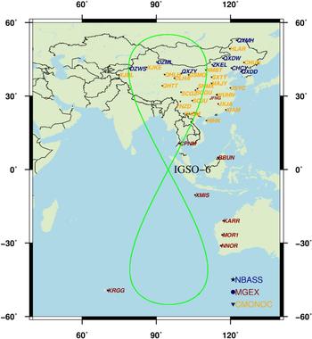
A new BDS IGSO satellite IGSO-6 was launched on 29 March 2016 (http://mgex.igs.org/IGS_MGEX_Status_BDS.html) and has been in operation since 18 May 2016, which has increased the number of IGSO satellites from five to six. Its ground track is depicted in Figure 1. Since the BDS-2 M5 satellite has malfunctioned since 2014 (Wang et al., Reference Wang, Yuan, Li, Montenbruck and Tan2016), the new satellite IGSO-6 is operated to ensure the quality and accuracy of service provided by the BDS-2 regional system. The Pseudo-Random Noise (PRN) of this new IGSO-6 satellite was switched from C15 to C13 on 11 October 2016. However, the new satellite was not available in the first week due to manoeuvring and adjustment according to the Space Vehicle (SV) health flag in its broadcast ephemeris. As a new IGSO satellite, it is not clear if there is any improvement on the performance of the signals in comparison with other IGSO satellites. Furthermore, there are some problems in the whole system, usually absent in other GNSS systems, such as the satellite-induced code bias and inter-frequency bias. It has not been specified whether IGSO-6 has the same problems. The impact of IGSO-6 on the whole system, especially in respect of SPP and PPP positioning performance, needs to be analysed.
The ground track of IGSO-6 and tracking stations selected from the NBASS, MGEX and CMONOC networks.

Several GNSS tracking networks, including the National BDS Augmentation Service System (NBASS), the Crustal Movement Observation Network of China (CMONOC) (Ma et al., Reference Ma, Chen, Ye, Lai, Wei, Chen, Ning, Xu and Ding2001), and the Multi-GNSS Experiment and Pilot Project (MGEX) are utilised for the analysis. The NBASS is a Chinese ground-based augmentation system (http://www.beidou.gov.cn/2017/06/07/201706076774fdba1bff4d4480c53a1bc3853bdd.html), which supports multi-GNSS (BDS, GPS and Global Navigation Satellite System (GLONASS)), extended with Galileo and provides a real-time precise positioning service. More than 150 well-distributed tracking stations were built with Chinese domestic receivers from ComNav, Huace, Unicorecomm and HI-TARGET. A subset of these stations was upgraded shortly after the signals were received from the IGSO-6 satellite. The CMONOC was established in 2000 and about 260 permanent GNSS tracking stations have been established since 2010 (Yang et al., Reference Yang, Song, Jiao, Chen, Xue, Zhou and Zhu2017), among which 25 stations have the capability to track BDS signals. MGEX is a campaign organised by the International GNSS Service (IGS) (Dow et al., Reference Dow, Neilan and Rizos2009) to track, collect and analyse all available GNSS signals (Montenbruck et al., Reference Montenbruck, Steigenberger, Khachikyan, Weber, Langley, Mervart and Hugentobler2014; http://mgex.igs.org/index.html). There are about 16 stations in the Asia-Pacific region with the ability to track BDS signals.
This study uses the measurements from 38 stations with BDS IGSO-6 signal tracking capability, which were selected from the MGEX, NBASS and CMONOC networks as shown in Figure 1. The IGSO-6 satellite's signal characteristics are analysed with respect to the Carrier-to-Noise-density ratios (C/N0), satellite-induced code bias, multipath and inter-frequency biases in the next section. To evaluate improvements of IGSO-6 on BDS positioning performances, the Position Dilution of Precision (PDOP) values in the BDS service region are evaluated, and then the impacts on the accuracy of SPP and the convergence time of PPP are discussed. Finally, some conclusions and remarks are given.
2. SIGNAL CHARACTERISTICS
To analyse the IGSO-6 satellite's signal qualities and characteristics, the C/N0 is evaluated and the satellite-induced code bias, multipath and inter-frequency biases are assessed in this section.
2.1. Carrier-to-noise Density Ratio (C/N0)
The C/N0 given by a receiver is a result of signal gain and loss along the complete transmitting and receiving chain (Hauschild et al., Reference Hauschild, Montenbruck, Sleewaegen, Huisman and Teunissen2012a). It is an essential and measurable signal-quality value in a GNSS receiver, which can be used to weight measurements (Wieser and Brunner, Reference Wieser and Brunner2000).
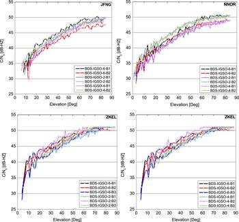
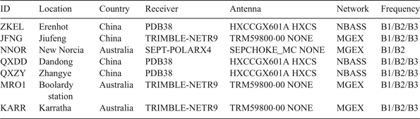
Figure 2 depicts the C/N0 as a function of the satellite elevations at stations JFNG, NNOR and ZKEL for IGSO-6, IGSO-2 and IGSO-4 in different orbit planes. The station information is listed in Table 1, and it should be noted that the B3 signal is supported except for IGSO-6 at station JFNG. Measurements on 17 June 2016 at these stations were used. Here, all the signals on three frequency bands (B1, B2, B3) are transmitted in Quadrature Phase-Shift Keying (QPSK) modulation on the I component (B1I, B2I, B3I) (Han et al., Reference Han, Yang and Cai2011). It is clear that the performances of the C/N0 for IGSO-6 are different at the selected stations with different receivers.
The C/N0 as a function of satellite elevation for IGSOs at the selected stations on 17 June 2016.

Selected GNSS monitoring stations with IGSO-6 tracking capability for the C/N0 and Multipath analysis.

At all the stations, especially at stations NNOR and ZKEL, it was found that the C/N0 for the B2 signal of the IGSO-2 and IGSO-4 satellite were approximately 2-3 dB-Hz more powerful than the B1 signal over the entire elevation range. In contrast, the result for IGSO-6 indicates that the B1 signal is more powerful than the B2 signal.
IGSO-6's B1 signal had a higher power level than any signals of IGSO-2 and IGSO-4, while the B2 signal had the lowest power level at station JFNG. At station NNOR, the B2 signal of IGSO-6 had a 2-3 dB-Hz lower power level compared with other IGSO satellites but not the lowest. IGSO-6's B1 signal was 1-2 dB-Hz higher than other IGSO satellites, and it became more powerful at high elevation angles. It is interesting to note the results of all triple-frequency signals at station ZKEL. The C/N0 of all signals became constant at high elevation angles. The reason for this phenomenon is that the fractional part of C/N0 is neglected according to the initial setting of the firmware of the PDB38 receiver. As the values of C/N0 change slightly at high elevation angles, with only variations in the fractional part, the C/N0 seems to have no variations in the figure at high elevation angles considering that the fractional part is neglected in the receiver. IGSO-6's B2 signal at station ZKEL was about 1-2 dB-Hz lower than the signals of other IGSO satellites, while IGSO-6's B1 signal had a 2-3 dB-Hz higher power level. For the B3 signal, IGSO-6 had a comparable level to IGSO-4 but 1-2 dB-Hz lower than IGSO-2.
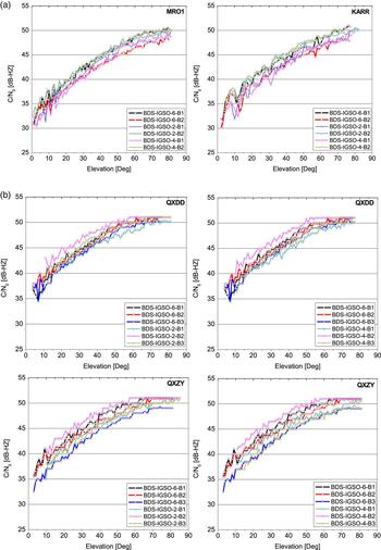
Another subset of stations with the same hardware was selected to investigate the key factors for different performances at the stations. The station information is again listed in Table 1, and it should be noted that the B3 signal is supported except for IGSO-6 at stations MRO1 and KARR during the day. The results are shown in Figure 3. The performances of C/N0 for IGSOs at stations MRO1 and KARR with TRIMBLE NETR9 receivers are similar and are shown in Figure 3(a). Figure 3(b) depicts a similar performance at stations QXDD and QXZY with PDB38 receivers. However, performance is apparently different for stations with differing hardware. At the station MRO1 and KARR, IGSO-6's B1 signal had a comparable performance with the B2 signals of IGSO-2 and IGSO-4, which was 1-2dB-Hz higher than the B1 signal of other IGSO satellites. However, IGSO-6's B1 signal at stations QXDD and QXZY is 1-2 dB-Hz less powerful than the B2 signals of IGSO-2 and IGSO-4. There are also some differences between stations with the same hardware, which is inevitable as this is related to the environment; the performances of C/N0 are more affected by the hardware.
The C/N0 as a function of satellite elevation for IGSOs at stations with same hardware on 17 June 2016.

2.2. Satellite-induced Code Bias
There is a characteristic of the present BDS IGSO/MEO satellites, namely the Satellite-induced Code Bias (SCB), which has been described as an elevation-dependent and frequency-dependent systematic bias (Hauschild et al., Reference Hauschild, Montenbruck, Sleewaegen, Huisman and Teunissen2012a; Montenbruck et al., Reference Montenbruck, Hauschild, Steigenberger, Hugentobler, Teunissen and Nakamura2013; Diessongo et al., Reference Diessongo, Schüler and Junker2014; Wanninger and Beer, Reference Wanninger and Beer2015). All stations in Table 1 and Figure 9 with BDS triple-frequency signal tracking capability for IGSO-6 were used to investigate the IGSO-6's SCB with the MP combination computed from the following equation (Hauschild et al., Reference Hauschild, Steigenberger and Rodriguez-Solano2012b):
 $${MP}_{A}= \rho_{A} -\lpar a + 1 \rpar \cdot \varPhi_{A} + a \cdot \varPhi_{B} + b$$
where ρA is the pseudo-range on the signal A, Φ A and Φ B are the carrier phase measurements on signal A and signal B, b is the bias caused by phase ambiguities and MP A is the code multipath of the signal A.  $a = 2\cdot f_{B}^{2}/\lpar \, {f}_{A}^{2}- f_{B}^{2}\rpar $, in which f A and f B are the corresponding frequencies of the signal A and signal B. This MP combination has eliminated all errors from the pseudo-range observation with the receiver noise, multipath errors and bias variations left. In general, the bias b in MP values is determined as the average over each pass and should be removed from the MP value (De Bakker et al., Reference De Bakker, Tiberius, Van Der Marel and Van Bree2012), however, there are still elevation-dependent bias variations left for BDS satellites after the averages have been removed. The elevation-dependent bias variations can be found in the MP time series for BDS satellites while they are usually absent for other GNSS systems These bias variations are generally referred to as the SCB. In this analysis, the MP combination of the B1 signal was formed with the carrier phase from the B2, while the B2 and B3 MP combinations were formed with the carrier phase from the B1 signal.
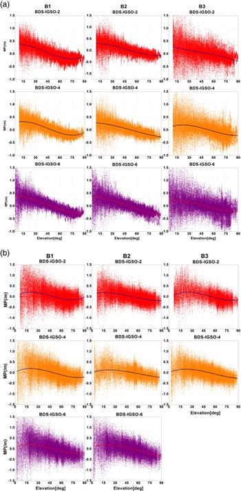
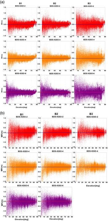
Figure 4 shows the MP combinations for the three frequencies (B1/B2/B3) of BDS IGSO satellites as a function of satellite elevation measured by the receiver PDB38 (Figure 4(a)) and TRIMBLE NETR9 (Figure 4(b)) for a period of one week at stations with triple-frequency tracking capability. Only IGSO-2, IGSO-4 and IGSO-6 were included in the analysis and the B3 signal of IGSO-6 is not supported by TRIMBLE NETR9. It is clear that there were systematic biases with non-zero mean in MP combinations for each frequency and receiver after the bias caused by phase ambiguities was removed. The IGSO-6 satellite also had similar characteristics. A cubic polynomial model as a function of satellite elevation with coefficients suggested by Lou et al. (Reference Lou, Gong, Gu, Zheng and Feng2017) for the three frequencies of BDS was applied to eliminate the systematic biases of IGSO satellites. The MP combinations for the three frequencies of BDS IGSO satellites with satellite-induced code bias corrected are depicted in Figure 5. The systematic biases in MP combinations were eliminated in Figure 5. It should be noted that the models for other IGSO satellites are also suitable for the new IGSO satellite IGSO-6.
The MP combinations of BDS IGSO satellites for the three frequencies at all stations 15–21 July 2016.

The MP combinations for the three frequencies of BDS IGSOs with SCB corrected 15–21 July 2016.

2.3. Noise and Multipath (MP)
MP is the interference between direct microwave signals from the satellites and reflected signals before reaching the antenna, which will affect GNSS observations and cause oscillations in observations (Roussel et al., Reference Roussel, Frappart, Ramillien, Darrozes, Baup, Lestarquit and Ha2016; Jin et al., Reference Jin, Qian and Wu2017). The MP combination is computed from the combination formula in Equation (1) as shown in the computations of Section 2.2 for the analysis of pseudo-range noise and multipath errors. The same stations selected for analysis of C/N0 are used.
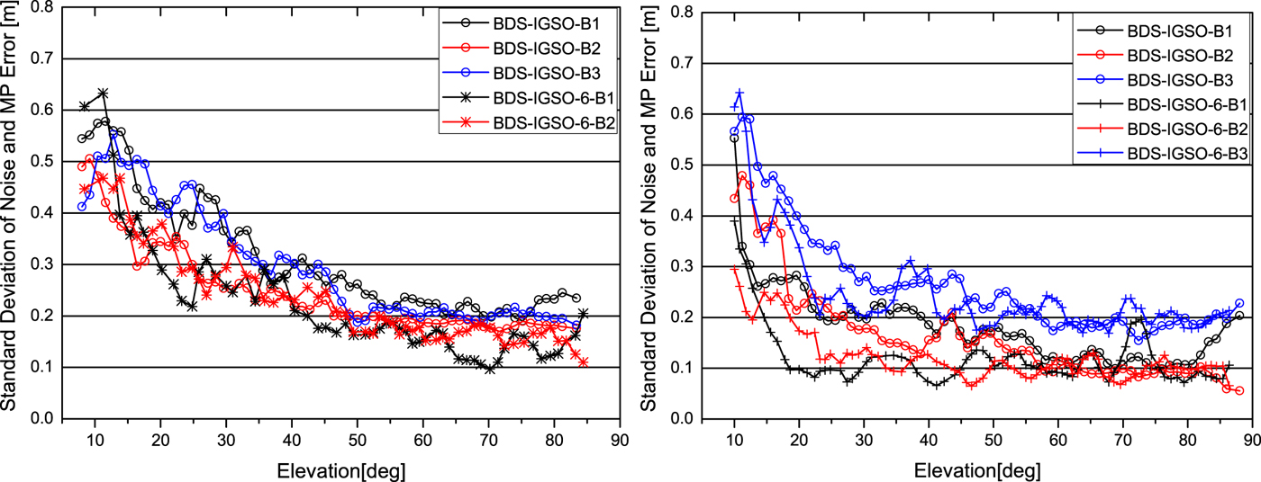
It should be pointed out that the SCB for BDS IGSO satellites discussed in Section 2.2 needs to be corrected, and the same SCB models used in the analysis are applied to all IGSO satellites including IGSO-6. The results of the MP combinations for the B1, B2 and B3 signals with SCB corrected at stations JFNG and ZKEL are depicted in Figure 6. The standard deviations of the noise and multipath errors of the multipath combinations over satellite elevation are illustrated in the plots. It is clear that IGSO-6's B1 signal showed the lowest noise and MP errors at both stations and the standard deviation reached the order of 10 cm. For the B2 signal, the performances of IGSO-6 and other IGSOs were comparable. Nevertheless, IGSO-6 had a better performance on all the three frequencies at ZKEL for low elevation angles. The standard deviation was at the level of 10 cm at ZKEL but 18 cm or more at JFNG for high elevation angles, which indicates that station JFNG seems to be affected more by MP and noise compared with ZKEL. The B3 signal of all IGSO satellites, including IGSO-6, exhibited the worst noise among all the three frequencies for low elevation angles and the standard deviation was of a level of 20 cm for high elevation angles at station ZKEL.
The standard deviations of the noise and MP errors for IGSOs at station JFNG (left) and ZKEL (right) 17–21 June 2016. Note that only the station ZKEL contributed to the IGSO-6's B3 signal results.

2.4. Inter-frequency Bias
With BDS carrier phase measurements available at three frequencies (B1/B2/B3), it is possible to form a triple-carrier combination Equation (2) in which the inter-frequency bias can be directly observed (Montenbruck et al., Reference Montenbruck, Hugentobler, Dach, Steigenberger and Hauschild2012; Li et al., Reference Li, Zhou and Wu2013).
 $$\matrix{ {DIF{\rm (}\varphi _1,\varphi _2,\varphi _3{\rm )}} \hfill & { = IF{\rm (}\varphi _1,\varphi _2{\rm )} - IF{\rm (}\varphi _1,\varphi _3{\rm )}} \hfill \cr {} \hfill & { = \left( {\displaystyle{{f_1^2 } \over {f_1^2 - f_2^2 }} - \displaystyle{{f_1^2 } \over {f_1^2 - f_3^2 }}} \right)\cdot \varphi _1 - \left( {\displaystyle{{f_2^2 } \over {f_1^2 - f_2^2 }}} \right)\cdot \varphi _2 + \left( {\displaystyle{{f_3^2 } \over {f_1^2 - f_3^2 }}} \right)\cdot \varphi _3} \hfill \cr } $$
where φ i(i = 1, 2, 3) are carrier phase observations at three frequencies f i(i = 1, 2, 3) respectively, and IF(φ i, φ j) (i,j = 1,2,3, i ≠ j) refers to the ionosphere-free linear combination with φ j and φ j. As discussed in Montenbruck et al. (Reference Montenbruck, Hugentobler, Dach, Steigenberger and Hauschild2012), the triple-frequency combination Equation (2) is both geometry-free and ionosphere-free. It signifies the difference of satellite clock offsets determined from two different pairs of signals and provides an indication of thermally-dependent inter-frequency biases. The combination includes not only the inter-frequency clock bias between the B1/B2 and B1/B3 ionosphere-free combinations, but also a constant ambiguity term.
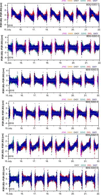
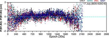
Six stations with BDS triple-frequency signal tracking capability were selected for the analysis. The stations JFNG and SNMX selected from MGEX and CMONOC are equipped with the TRIMBLE NETR9 receiver while the other stations selected from the NBASS are all equipped with the PDB38 receiver and firmware. The B3 signal is supported by the TRIMBLE NETR9 receiver for all but the signal from IGSO-6. Figure 7 depicts the triple-frequency combination of carrier phase measurements for six BDS IGSO satellites at the selected stations over a period of one week, where the constant ambiguity terms were removed for each pass. The difference between the Ionosphere-Free (IF) combination of B1 and B2 and the IF combination of B1 and B3 was used to form the triple-frequency combination in the plots. It can be seen that there was a daily periodic variation for each IGSO satellite. However, the variations of biases for IGSO satellites on one day were different from each other. As for the new IGSO satellite IGSO-6, the variations of biases for IGSO-6 on 17 July 2016 are illustrated in Figure 8, which shows that IGSO-6 also has systematic variations. By comparison, the variations of biases for IGSO-6 are similar to IGSO-2 on the same day, and those of IGSO-3 are more like IGSO-4, while the trend of variations for IGSO-1 seems to be opposite to IGSO-5, but they are similar at all six stations over the whole week for each IGSO satellite. The explanations of these phenomena remain unclear, but as a whole, there was a daily repeatability but no visible systematic variation among the stations, which indicates that the inter-frequency bias is satellite-dependent and uncorrelated between the stations. The reason for inter-frequency biases of IGSO satellites including IGSO-6 will be investigated further.
The triple-carrier combinations of BDS IGSOs at the selected stations 15–21 July 2016.

The triple-carrier combinations of IGSO-6 at the selected stations for one day (17 July 2016).

3. BDS POSITIONING PERFORMANCE
In order to analyse the impact of IGSO-6 on BDS positioning performance, the PDOP values in the BDS-2 service region are evaluated first, then positioning in both SPP and PPP modes are discussed. The discussions also show the current positioning performance of BDS-2 in the service region.
3.1. Data and Strategy
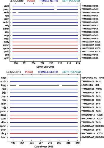
The tracking stations in Figure 1 with IGSO-6 tracking capability were selected for the positioning performance analysis. The datasets of these stations were collected for a period of three weeks from 15 July to 5 August 2016. All the information for the stations is illustrated in Figure 9.
The time period of selected GNSS monitoring stations used for the positioning performance analysis. The colours represent different types of receivers and the antenna configuration of each station is listed on the right.

At the low-latitude stations CPNM, XMIS and BRUN, the IGSO-6 satellite is visible during the whole day, and most stations in China have a visibility period of 18-20 hours, but for stations located in high-latitude regions such as stations KRGG and QXMH, the visible period is shorter than 16 hours per day. A cut-off elevation mask angle of 7° was chosen and data sampling is set to 30 s for usable measurements (Chen et al., Reference Chen, Wang, Zhang, Yang, Chen and Gong2016). In SPP, the processing strategy is similar to that described in Yang et al. (Reference Yang, Li, Wang, Xu, He, Guo, Shen and Dai2014). The pseudo-range observations from the BDS B1 signal were used and the Klobuchar model from the BDS broadcast ephemeris was applied to the ionosphere delay errors correction. For PPP, the same strategy discussed in Lou et al. (Reference Lou, Zheng, Gu, Wang, Guo and Feng2016) was used with post-processed BDS precise satellite orbit and clock products from MGEX (Deng et al., Reference Deng, Ge, Uhlemann and Zhao2014). Some data pre-processing was applied to ensure that the IGSO-6 observations were added from the beginning, which could make full use of IGSO-6 observations in the PPP convergence.
Epoch-wise positioning errors were obtained by comparing the positioning solutions to the precise coordinates to mm-level accuracy as references. The precise coordinates were calculated using the Position And Navigation Data Analysis software (PANDA) developed by Wuhan University of China (Liu and Ge, Reference Liu and Ge2003). To evaluate the positioning performance, the positioning accuracy was given for SPP at the 95% confidence level. For PPP, the convergence times were included in the statistics, and the results of the convergence time were at the 95% and 68% confidence levels, respectively.
3.2. PDOP
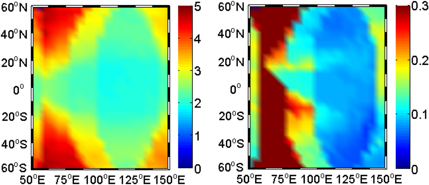
The broadcast ephemeris of BDS from 15-21 July 2016 was used to calculate the PDOP values in the BDS service region (55°S-55°N and 70°-150°E) (Ran, Reference Ran2011), and results are shown in Figure 10. Both the PDOP values and the average improvement in PDOP values with IGSO-6 are shown in the figure. It can be seen that the PDOP values with IGSO-6 were smaller in the whole service region when compared to the PDOP values without using IGSO-6. Improvements were significant in the area 50-100°E, where fewer visible satellites can be observed than in other regions, therefore, the new IGSO satellite IGSO-6 can greatly enhance the satellite geometric configurations in the area. However, there were few improvements with IGSO-6 in the central area of the BDS service region, which have the best observation environment in the BDS service region and IGSO-6 has less contribution to the PDOP values.
The PDOP values (left) and improvements (right) with IGSO-6 in the BDS service region. The improvements were obtained from the differences of the PDOP values with and without IGSO-6.

3.3. SPP
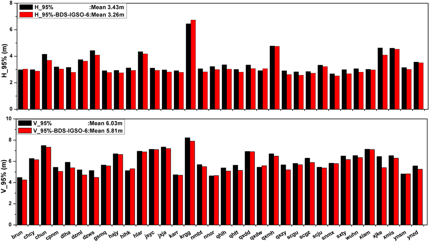
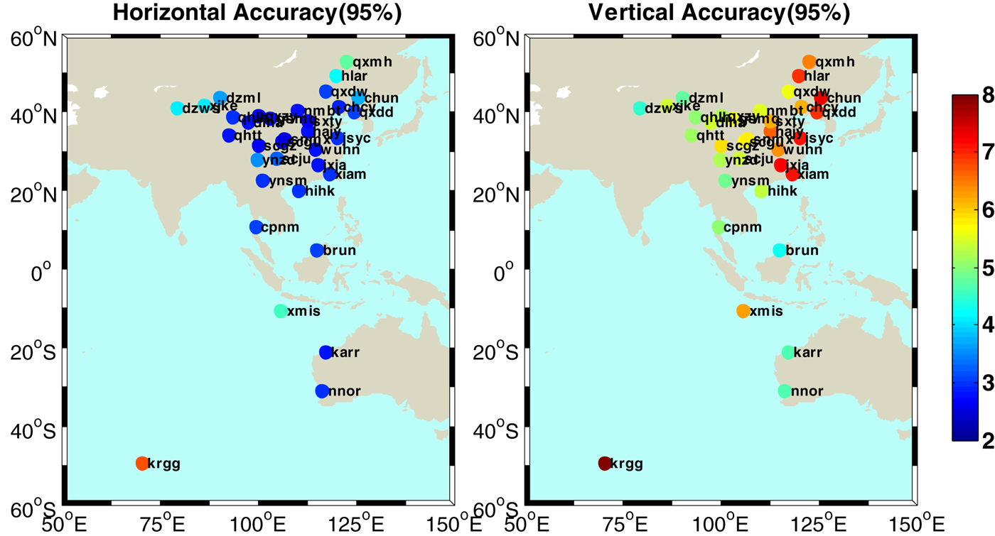
The results of positioning accuracy at the 95% confidence level in the horizontal and vertical components over three weeks are shown in Figure 11. A control group of positioning without using the IGSO-6 observations is set for comparison. The positioning solutions with the IGSO-6 observations performed better at most stations. There was an improvement of about 3·6% in the vertical, reduced from 6·03 m to 5·81 m, and 4·9% in the horizontal, reduced from 3·43 m to 3·26 m. The improvement was especially significant at station XJKE, where the positioning accuracy is improved by about 16·4% in the vertical, reduced from 6·46 m to 5·40 m and improved by about 11·7% in the horizontal, reduced from 4·63 m to 4·09 m.
The positioning accuracy (95%) of each selected station in the horizontal and vertical components over three weeks are given. The results without IGSO-6 (in black) serve as a control group for comparison.

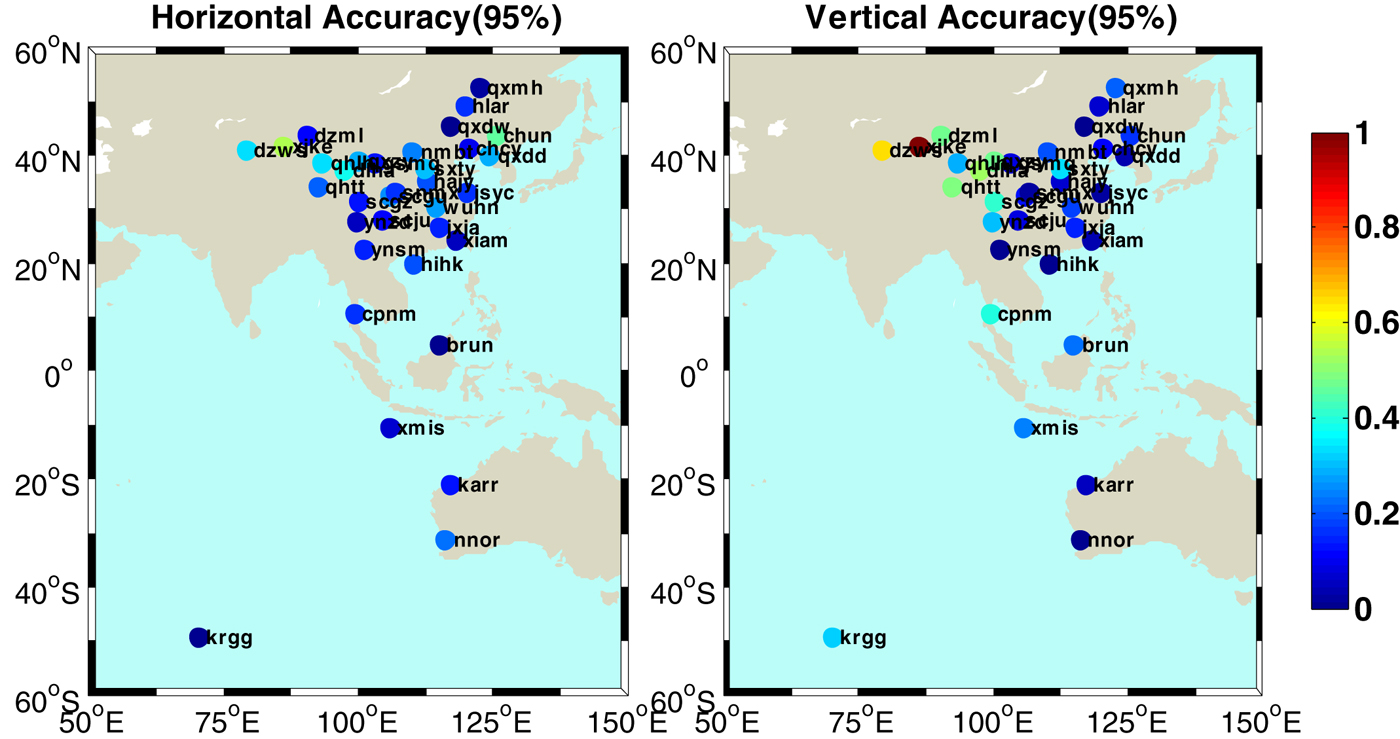
Figure 12 also shows the positioning accuracy (95%) of each station, while Figure 13 illustrates the improvement in positioning accuracy with IGSO-6 at each station. It is interesting to note that the positioning accuracy in the vertical component was obviously improved in the west of the BDS service region, where an apparent reduction in the PDOP value with IGSO-6 is shown in the PDOP values in Figure 10. However, the positioning performance at KRGG and XMIS seems to be poor no matter whether the IGSO-6 observations were used or not, from which it could be inferred that the correction precision of the BDS ionospheric model is low in the low-latitude and high-latitude regions of the southern hemisphere (Wu et al., Reference Wu, Hu, Wang, Zhong and Tang2013).
The distribution and positioning accuracy (95%) of each station in the horizontal and vertical components with IGSO-6 over three weeks. The colours of cycles represent the value for positioning accuracy ranging from 2 to 8 m.

The improvement of positioning accuracy (95%) at each station in the horizontal and vertical components with IGSO-6 over three weeks. The colours of cycles represent the value for improvement ranging from 0 to 1 m.

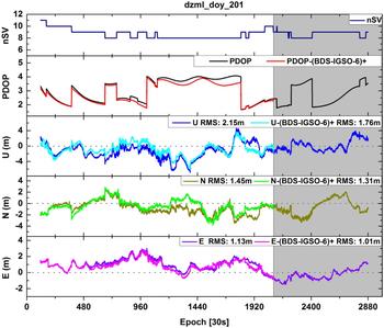
The results of SPP at the station DZML are shown in Figure 14 as an example. The PDOP values varied from 1·5 to 4·2. It reduced by 0·6 at most and 0·2 on average after adding IGSO-6, and the Root Mean Squares (RMSs) of position errors were 1·01 m, 1·31 m and 1·76 m in the east, north and up components, respectively. It is clear to see that the positioning performance with IGSO-6 was better than the result without IGSO-6 in the first part, while the performance was the same in the rest of the shaded part of the plot when IGSO-6 was not visible.
The results of SPP with and without IGSO-6 at the station DZML on 19 July 2016.

3.4. PPP
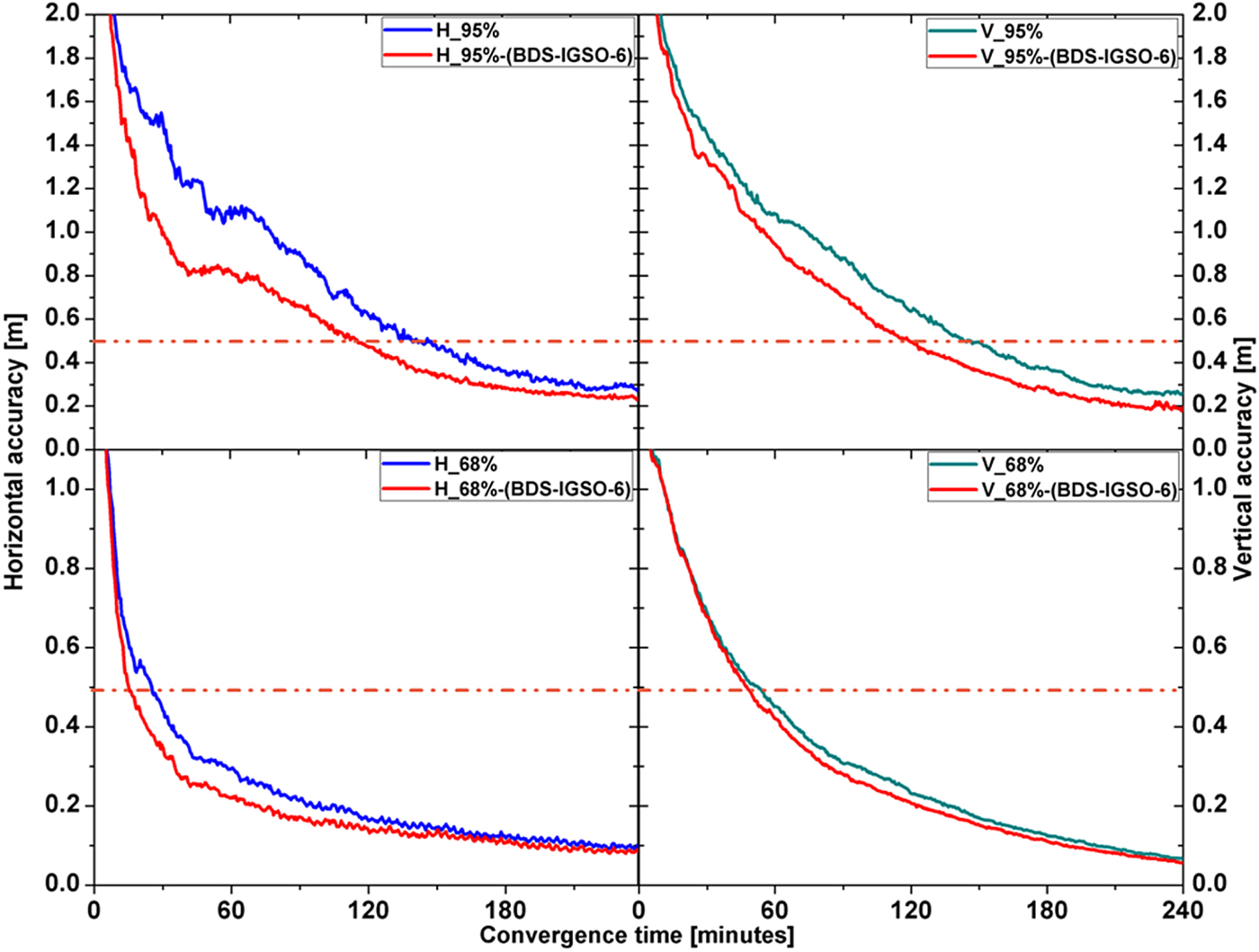
For PPP, a control group without using the IGSO-6 observations is also set for comparison. Figure 15 illustrates the positioning accuracies (95% and 68% confidence level) with convergence time in the horizontal and vertical components using the strategy in Section 3.1 for all selected stations over the three weeks. It can be seen that the convergence of the horizontal and vertical components for PPP were accelerated with the IGSO-6 observations. It took about 136 minutes for the horizontal positioning accuracy (95%) to be better than 50 cm and about 146 minutes in the vertical component. There was an improvement of about 18·3% in the horizontal direction, reduced from about 142 minutes to about 116 minutes and about 17·8% in the vertical direction, reduced from about 146 minutes to about 120 minutes at the 95% confidence level. The results at the 68% confidence level show similar effects to that of IGSO-6.
The positioning accuracy (95% and 68%) with convergence time in the horizontal and vertical component. The results with IGSO-6 are plotted in red.

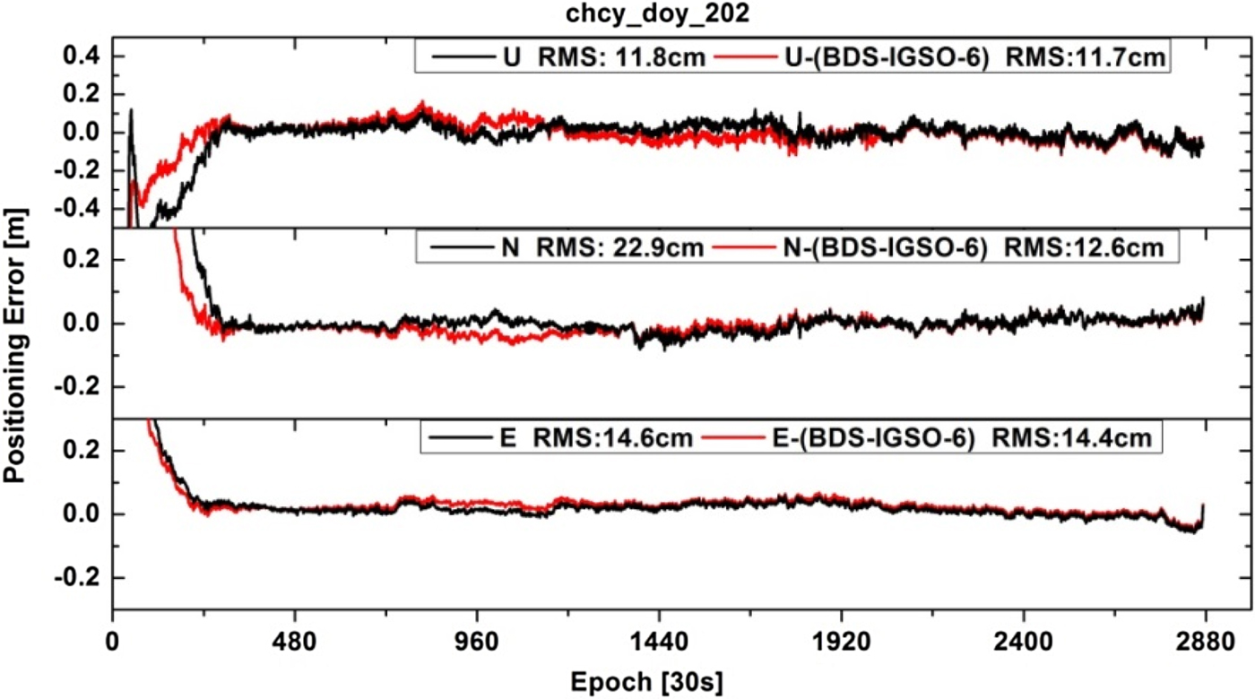
The positioning performances of PPP with and without IGSO-6 at the station CHCY are depicted in Figure 16 as an example.
The results of PPP with and without IGSO-6 at the station CHCY on 20 July 2016.

The RMSs of PPP with IGSO-6 were 14·4 cm, 12·6 cm and 11·7 cm in the east, north and up components. It is obvious that the convergence of PPP was accelerated significantly with the IGSO-6 observations. The accuracy of PPP with IGSO-6 was also improved, especially in the north component, considering that IGSO-6 mainly had contributions to the convergence and results of the whole day were involved in the statistics.
4. CONCLUSIONS
The number of BDS IGSO satellites was increased from five to six with the recent IGSO-6 satellite joining the constellation. This paper has focused on the signal characteristics and impact of the newly launched IGSO-6 on BDS positioning performance. Based on the 38 stations selected from the NBASS, MGEX and CMONOC networks, the C/N0, satellite-induced code bias, noise and multipath and inter-frequency bias were evaluated, and finally the impact on BDS positioning performance has been demonstrated.
The C/N0 of IGSO-6 and other IGSO satellites were compared for three types of receivers at different stations. Contrary to other IGSO satellites, the B1 signal for IGSO-6 had the best performance among all triple-frequency signals. It was 2-3 dB-Hz higher than other IGSO satellites for the B1 signal. However, the B2 signal of IGSO-6 was less powerful than other IGSO satellites, and the B3 signal had a comparable power level. The SCB of IGSO-6 triple-frequency observables were compared with other IGSO satellites and the same characteristics were found, which can be corrected by the same models as for other IGSO satellites. The multipath combination was utilised to analyse the pseudo-range multipath and noise for two stations, in which the SCB of BDS IGSO satellites including IGSO-6 were corrected. It is interesting to note that the B1 signal of IGSO-6 had the lowest noise and multipath errors at both stations while the performances of IGSO-6's B2 and B3 signals were comparable with other IGSO satellites. Moreover, the inter-frequency bias of IGSO-6 has daily periodic variations and systematic variations, which are different from those of other IGSO satellites.
The impact of IGSO-6 on BDS positioning performance was analysed in SPP and PPP modes for three weeks. The results indicate that on average the positioning accuracy (95% confidence level) of SPP can be improved by about 22 cm in the vertical component and 17 cm in the horizontal component with IGSO-6. The BDS PPP performances are also significantly improved when adding IGSO-6. In comparison with the results excluding the IGSO-6 observations, the convergence time of PPP with IGSO-6 can be reduced by about 26 minutes in both the horizontal and vertical components for positioning accuracy (95% confidence level) to be better than 50 cm. Since BDS-2 is a regional system, the improvements brought by IGSO-6 are not obvious outside the official service region, however, within the service region, the performance improvement is promising. Despite the limited service region of the BDS-2 regional system, it can be anticipated that the BDS positioning performance will be greatly improved when the BDS-3 constellation of 35 satellites is completed as a global navigation satellite system.
ACKNOWLEDGMENTS
This work was supported by the National Key Research and Development Program of China (2016YFB0501800), the National Natural Science Foundation of China (41774036), and the Fundamental Research Funds for the Central Universities (2042017kf0179).